You are currently viewing a new version of our website. To view the old version click .
Journal of Marine Science and Engineering
  • Article
  • Open Access

19 May 2024

Deployment Method for Aircraft-Based Maritime Emergency Communication Resource Reserve Bases

and
College of Information Engineering, Shanghai Maritime University, Shanghai 201306, China
*
Author to whom correspondence should be addressed.
This article belongs to the Section Ocean Engineering

Abstract

Maritime emergency communication facilities play a crucial role in establishing communication links between land and sea, serving as essential communication means for maintaining maritime safety, disaster response, and emergency rescue operations. With the increasing frequency of marine activities, the rapid response capability of maritime emergency communication is becoming increasingly critical. With their characteristics of high-speed mobility, broad coverage and flexibility, aircraft serve as carriers for emergency communication facilities. The selection of aircraft bases is paramount in meeting the requirement of rapid response for maritime emergency communication. In this paper, we present a multi-objective optimization model for site selection by considering the coverage capabilities of different carriers. The model incorporates hierarchical coverage of unmanned aerial vehicles (UAVs) and helicopters with a genetic algorithm. Through a case study of the Bohai Sea, this paper verifies the feasibility and effectiveness of the model.

1. Introduction

During maritime accidents or emergencies, Search and Rescue (SAR) operations play a vital role in providing assistance to mitigate various losses. One critical element is the establishment of maritime communication connections, which is essential for SAR operations. Existing maritime communication methods face numerous challenges in meeting the demands of emergency communication at sea. Air-based maritime communication relies on satellite communication, which excels in broad coverage due to the altitude of satellites and achieves global coverage through satellite networking. However, satellite communication is expensive and not cost-effective for large data transmission, and is vulnerable to attacks during military conflicts. Sea-based maritime communication encompasses communication networks involving islands, large vessels, drones, and marine aircraft. These networks can meet diverse and dynamic communication needs at sea depending on their positioning and role. Land-based maritime communication utilizes mature land-based communication technologies such as ground cellular networks, wireless metropolitan area networks, and wireless local area networks. It has limited communication distance and only provides services for coastal areas. However, the high cost of satellite transmission makes it difficult to adopt widely, while maritime radio is constrained by bandwidth limitations, and can only achieve limited voice communication [1,2,3]. Maritime emergency communication’s rapid response capability is crucial, especially during emergencies such as natural disasters or conflicts, where communication restoration is essential for ensuring personnel safety and coordinating rescue operations. Existing maritime communication methods do not adequately address the specific needs of maritime emergency communication scenarios. For the specific needs of maritime emergency communication, utilizing aircraft to deploy communication facilities offers a novel solution, and communication facility bases are the foundation. Rational site selection for these bases reduces response time and avoids redundant construction, enhancing resource utilization.
The location of maritime emergency communication facilities is a complex issue that requires consideration of response time, the service capacity of alternative bases, and the risk levels of demand points. Because response time largely depends on the quantity and location of emergency facilities, determining the optimal number and location is strategically significant. This paper proposes a method for siting maritime emergency communication facilities based on aircraft deployment and selecting helicopters and UAVs to carry communication equipment. Considering the varying risk levels of maritime demand points and the heterogeneous service capacities of different bases, we aim to minimize the number of UAV bases and maximize the risk coverage value of helicopter bases, constructing a hierarchical coverage model for siting maritime emergency communication facilities. This method fully utilizes the extensive coverage range and strong adaptability to sea conditions of helicopters, enabling rapid coverage of large sea areas, which is crucial for shortening response times. UAVs have the advantage of flexible deployment, enabling quick response and deployment of communication nodes within a short period.
The primary contributions of this paper entail analyzing the challenges in maritime emergency communication, introducing a multi-objective site selection optimization model, designing a dual-population genetic algorithm to resolve it, and validating its feasibility and effectiveness through a case study. The paper proceeds as follows: Section 2 outlines the research progress related to facility location; Section 3 delves into detailed insights into the dual-carrier facility location problem model; Section 4 elaborates the genetic algorithm employed to address the model, followed by experiments and analysis; Section 5 discusses the characteristics of the model and potential limitations; finally, Section 6 concludes the paper by drawing conclusions and suggesting future research directions.

3. Dual-Carrier Facility Base Selection Model

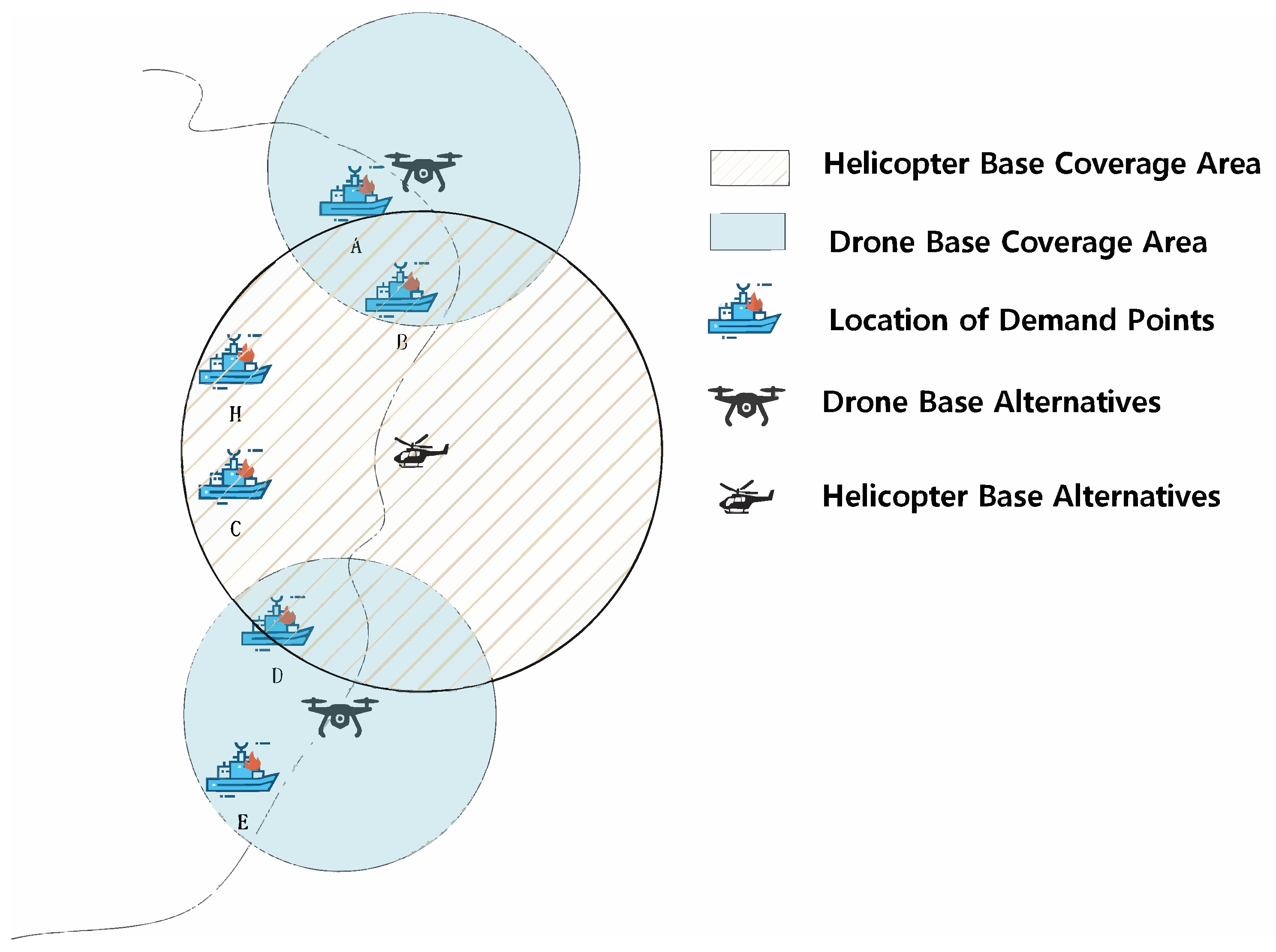
3.1. Base Selection Strategy

Maritime emergency facility siting presents complex and long-term location challenges, which are often tackled using sophisticated coverage models. This paper presents the Dual-carrier Facility Site Selection Model (DcFSSM), a new method designed to address these challenges.
Maritime emergencies are characterized by their suddenness and rapid escalation, posing significant risks and potential consequences. In such scenarios, the swift response capability of maritime emergency communication is paramount. To enhance the response speed of maritime emergency communication, this paper presents an innovative approach that employs aircraft as carriers for maritime emergency communication resources, representing an alternative to the conventional vessel response method. In response to the challenge of traditional site selection models failing to balance cost and efficiency considerations, this study integrates the relative advantages of LSCP and MCLP and proposes a graded coverage strategy. The primary objective of the DcFSSM is to optimize the deployment of two key carriers: unmanned aerial vehicles (UAVs) and helicopters. This optimization process minimizes UAV bases and maximizes helicopter base coverage capacity. This dual-carrier approach ensures comprehensive and efficient coverage of maritime areas by catering to various emergency scenarios and demands.
As shown in Figure 1, the DcFSSM utilizes a hierarchical coverage model that prioritizes UAVs for emergency requests within their coverage range. For demand points located beyond the reach of UAVs, helicopters are deployed to provide swift and effective service. This hierarchical arrangement allows for seamless coordination and collaboration between UAVs and helicopters, maximizing their strengths and capabilities.
Figure 1. Maritime emergency communication dual-carrier siting layout.
Strategic planning and placement of UAVs and helicopters are crucial for optimizing emergency response efforts. By leveraging the unique characteristics of each carrier and considering factors such as response time, demand distribution, and risk levels, the DcFSSM ensures efficient resource allocation and enhances the overall effectiveness of maritime emergency communication.

3.2. Model Construction
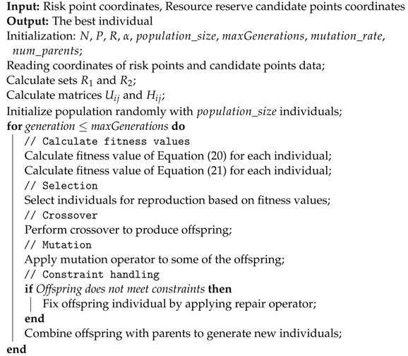
The parameters of DcFSSM are detailed in Table 2.
Table 2. Parameters and interpretations.
The target maritime area is divided into several zones, with the center point of each zone serving as a demand point. This study quantifies the risk levels R associated with demand points to match the layout of maritime emergency communication facilities. The risk assessment is described by (18), with the normalized risk value C j depicted in (19).
R = n N × S × T × A × G
C j = R j min ( R j ) max ( R j ) R j
Here, R represents the risk, n represents the number of ship accidents in the study area category, N represents the total number of ship accidents in the maritime area, S represents the ship type coefficient (see Table 3), T represents the ship size coefficient (see Table 4), A represents the accident area coefficient (see Table 5), and G represents the accident grade coefficient (see Table 6).
Table 3. Ship type conversion coefficients.
Table 4. Ship type, size, and conversion coefficients.
Table 5. Different importance coefficients for different sea areas.
Table 6. Accident grade and conversion coefficients.
The coverage range of alternative bases is influenced by both the flight speed of helicopters and UAVs and by the maximum response time for emergency communication. If the distance from a demand point to a candidate site falls within the coverage range of the drone base, we categorize it as an I-demand point; otherwise, it is an II-demand point.
The DcFSSM is described by the following equations.
Minmize i = 1 N X i
Maxmize j = 1 R 2 C j Z j
Subject to i = 1 N Y i = P
i = 1 N U i j X i 1 j R 1
i = 1 N H i j Y i Z j j R 2
X i , Y i , Z j 0 , 1 i I , j R 2
U i j 0 , 1 i I , j R 1
H i j 0 , 1 i I , j R 2
Equations (20) and (21) serve as the optimization objectives of the model, namely, minimizing the number of UAV bases and maximizing the coverage capability of helicopter bases. Equation (22) restricts the maximum number of helicopter bases. Equation (23) ensures that at least one UAV base responds to emergency requests from each I-demand point. Equation (24) ensures that only selected bases capable of covering II-demand points can respond to emergency requests.

4. Solution

This section presents the algorithm and a case study of DcFSSM.

4.1. Improved Genetic Algorithm

Emergency facility location models can be solved using either exact or approximate algorithms. Exact algorithms aim for optimal solutions but become impractical with larger problem sizes due to increased time and space complexity [21]. GAs progressively evolve a population of potential solutions to find the optimal solution for an optimization problem [22]. The maritime emergency communication facility location problem, being NP-hard, is tackled in this study using a Dual-Population Genetic Algorithm (DPGA). Compared to traditional genetic algorithms, the DPGA introduces two populations, dedicated to solution search and evolution, respectively. This dual-population structure enhances the algorithm’s search efficiency and global optimization capability. DPGA achieves comprehensive exploration and optimization of the solution space through the collaborative evolution between the two populations. One population is responsible for exploring new solutions within the solution space, while the other is tasked with selecting and evolving excellent individuals based on specific selection strategies.
In DPGA, classical genetic operations drive population evolution. Selection identifies fit individuals based on fitness using the roulette wheel method to maintain diversity. Equation (28) demonstrates the probability of an individual being selected as a parent individual. The crossover operation involves exchanging gene segments between paired individuals from both populations to generate new offspring. Mutation randomly alters individual gene values to introduce diversity and prevent premature convergence. These genetic operations facilitate ongoing population evolution and optimization, ultimately leading to the optimal solution. The pseudocode implementation is shown below (see Algorithm 1).
p ( x i ) = F ( x i ) j = 1 N F ( x j )

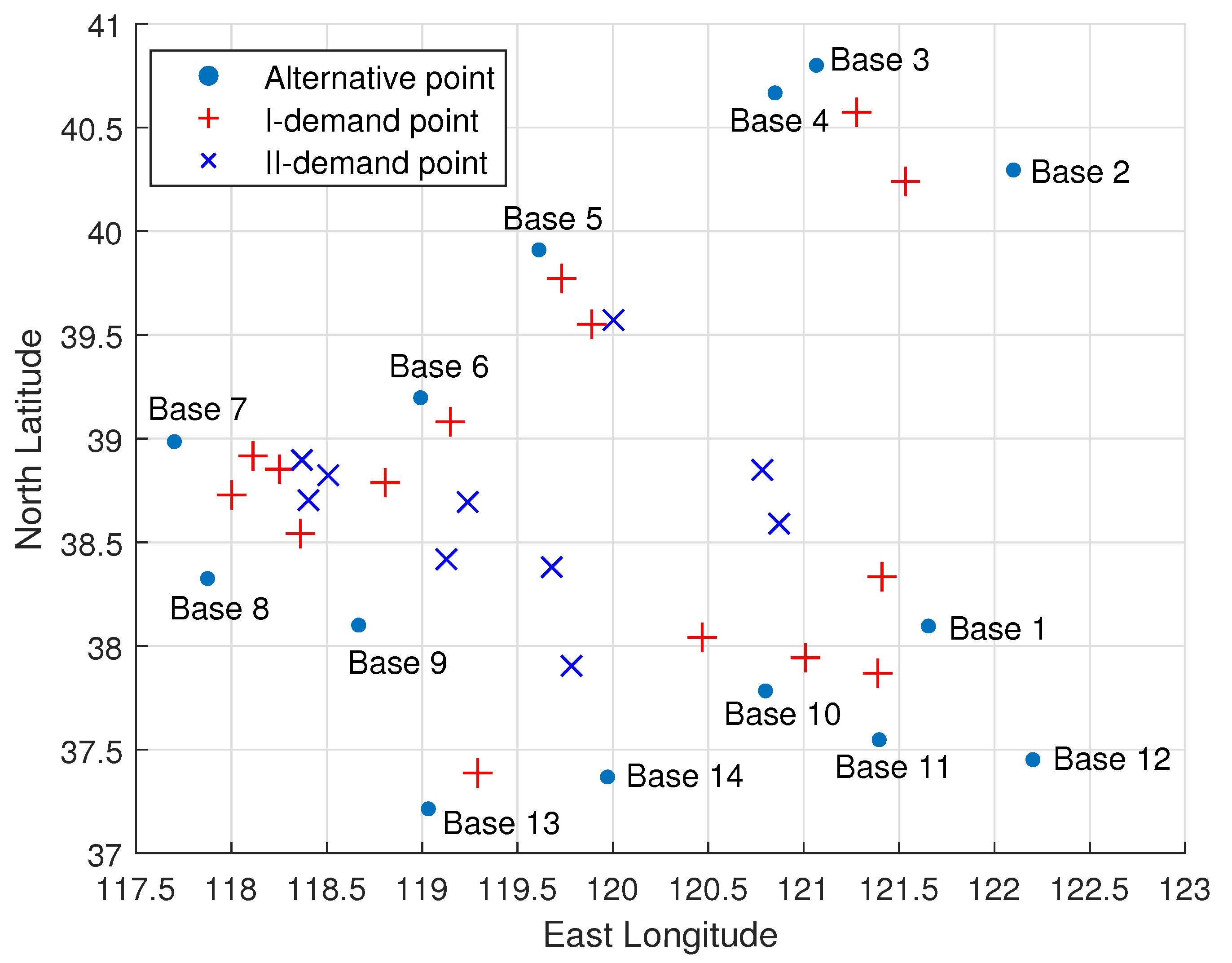
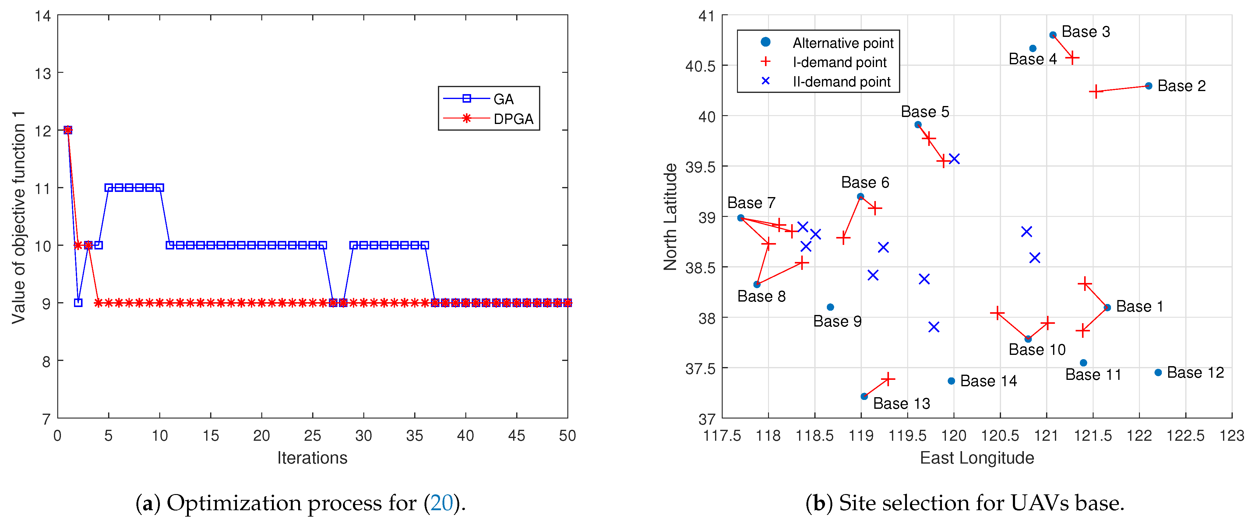
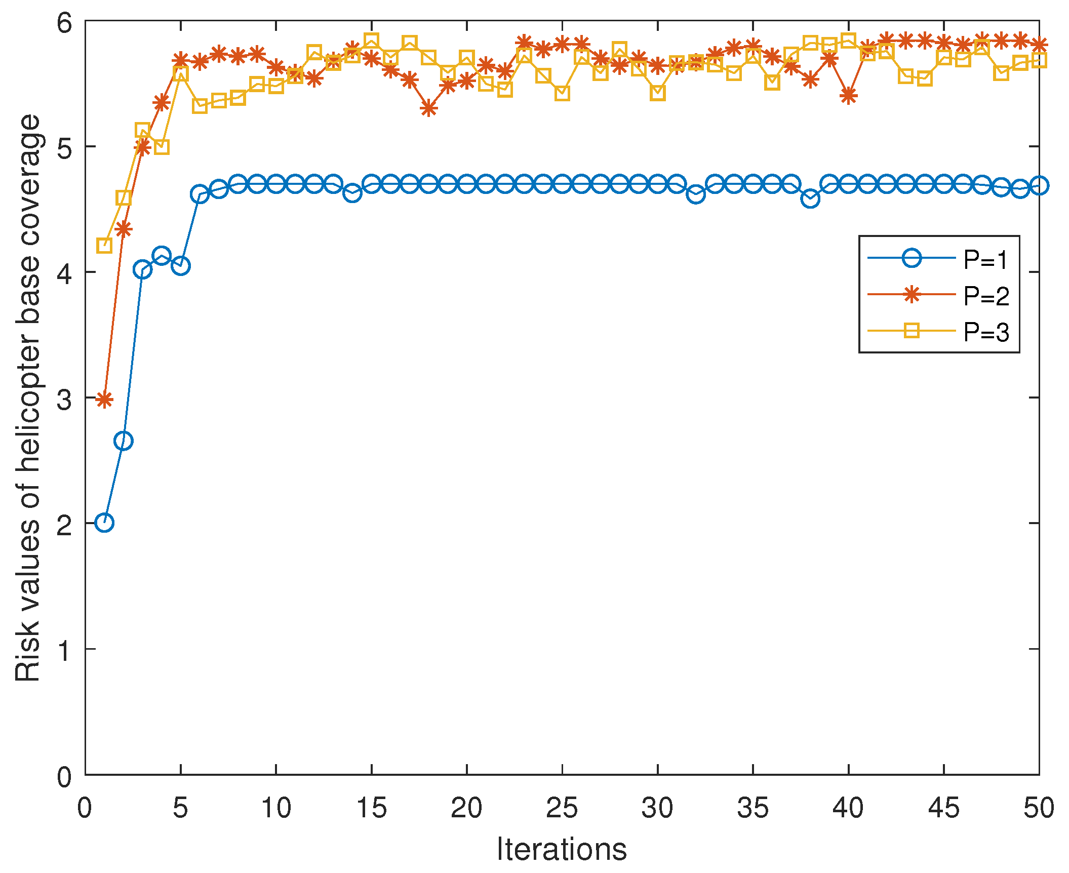
4.2. Case Study of the Bohai Sea

The principles governing the selection of emergency communication resource reserve bases at sea encompass various factors. Foremost among these is the critical importance of geographical location, emphasizing proximity to busy maritime traffic lanes or vital shipping routes to facilitate swift responses to emergency communication demands. Furthermore, these reserve points must possess the necessary resources to swiftly respond to maritime accidents, encompassing specialized personnel, state-of-the-art equipment, and sufficient material reserves. This assurance guarantees the effectiveness and timeliness of emergency responses, thereby fostering a sense of security and reliability in critical situations. Moreover, it is imperative to comprehensively consider factors such as scale, operational logistics, management strategies, and construction expenditures to ensure the sustainable development and functionality of these emergency communication resource reserves. Only through a comprehensive assessment of these elements can suitable emergency communication resource reserve bases at sea be identified in order to provide timely and effective assistance during maritime emergencies.
Algorithm 1: Dual-Population Genetic Algorithm (DPGA)
Jmse 12 00844 i001
Building upon the existing offshore emergency rescue base construction in the Bohai Sea region, this paper has identified fourteen offshore emergency communication resource reserve bases. Table 7 presents the location data.
Table 7. Latitude and longitude for alternative bases [23].
Utilizing the Bohai Sea-related data, we assessed the risk level of demand points using (18). Subsequently, we normalized the derived risk level values with (19) to acquire the risk weighting coefficients. The resulting weights are presented in Table 8. This step aims to quantify the risk level of each demand point and convert it into comparable weighting coefficients for consideration in subsequent analysis and decision-making processes.
Table 8. Location and weights of demand points.
Following the method described in Section 2, demand points are categorized into I-demand and II-demand, as illustrated in Figure 2.
Figure 2. Demand points and distribution of resource reserve candidate bases.
Figure 3 and Figure 4 illustrate the optimization process and site selection results. In Figure 3, the UAV base can serve I-demand points and fulfill all emergency requests from I-demand points. The optimization objective of (20) is to minimize the number of UAV bases, as depicted in Figure 3a of the simulation experiment results. It is observable that the number of bases exhibits a decreasing trend when using DPGA, rapidly converging and stabilizing after the first five iterations. While the GA yields the same result, its convergence speed is noticeably slower than the DPGA, and the convergence process of the GA is unstable. The minimum number of UAV bases required to cover all I-demand points is 9, as depicted in Figure 3b. The figure illustrates the selected UAV base candidates and the demand points they can cover.
Figure 3. Optimization process and site selection for UAV bases.
Figure 4. Optimization process and site selection for helicopter base.
The helicopter base is dedicated to serving II-demand points, with a focus on responding to demand points associated with higher quantified risks. This prioritization is driven by the practical challenges of ensuring responses to all emergencies originating from II-demand points. Such a strategy aligns with the second optimization objective of the model (21), which aims to maximize the coverage capacity of helicopters.
Figure 4a provides insights into the optimization process, showing the rapid accumulation of the cumulative risk value of demand points covered by helicopter bases as the number of iterations progresses. It is noteworthy that this cumulative risk value stabilizes after the tenth iteration. However, the stability of the optimization process using DPGA is significantly superior to that using GA. Examining Figure 4b, it becomes apparent that achieving coverage for all II-demand points requires only two helicopter bases. This outcome fulfills the optimization objective outlined in (21), thereby contributing to cost reduction in operations, and allows for multiple coverages for certain II-demand points. This aspect underscores the reliability and robustness of the site selection method employed in this study.
Figure 5 illustrates the existence of an optimal solution for the helicopter base location layout in this application scenario for helicopter coverage risk at different values of P. It can be observed that the cumulative risk values when P equals 2 or 3 are significantly higher than when P equals 1, indicating that increasing the number of helicopter bases can enhance the system’s coverage capability. However, when P equals 2 or 3, the cumulative risk values stabilize, indicating that increasing the number of helicopter bases further does not improve the cumulative risk values, and leads to an increase in operational costs. This suggests that a value of P equal to 2 represents the optimal layout for helicopter bases in this scenario.
Figure 5. Impact of helicopter base quantity on coverage risk.

5. Discussion

In maritime emergency communication scenarios, a pivotal concern lies in how to respond to emergency communication requests within a designated timeframe. Considering that response time is largely determined by the quantity and placement of emergency facilities, determining the optimal number and positioning of these facilities holds significant strategic importance. We have developed a DcFSSM model to address the deployment issue of maritime emergency communication resource reserve points. Compared to existing methods for maritime emergency communication, this solution offers significant advantages in terms of flexibility, response speed, and cost-effectiveness, while meeting the demand for emergency communication in both natural disasters and military scenarios. A DPGA is employed to solve the DcFSSM model. The DPGA introduces two populations for cooperative evolution, thereby enhancing global search capability while maintaining diversity. Additionally, by optimizing different objectives separately, DPGA improves solution efficiency. A comparative analysis reveals that DPGA outperforms GA in terms of convergence speed and stability of the convergence process.
First, the distance from each demand point to all candidate points is calculated based on coordinate parameters. Subsequently, considering the response time and aircraft performance parameters, the coverage ranges of aircraft are determined. Based on the coverage capabilities of the aircraft, demand points fall into the classes of I-demand points and II-demand points. To ensure that the site selection outcomes align with maritime risk levels, a maritime risk assessment is conducted to identify areas with higher risk values.
In DcFSSM, objective function 1 (20) aims to minimize the number of UAV bases using an ensemble coverage model. The results show that nine UAV bases are required to cover all I-demand points, with some demand points potentially receiving multiple coverages. Additionally, it is worth noting that some of the bases are underutilized; this issue warrants continued research. Utilizing UAV bases to deploy emergency communications resources has multiple advantages. First, the flexibility of UAVs makes it possible to quickly respond to sudden emergency communication needs and provide timely communication support. Second, utilizing UAV bases for deploying emergency communication resources may offer a more cost-effective solution, especially for maritime emergency communication. Finally, demand-based scalability allows for flexible adjustment of the size of communication facilities at the UAV bases, realizing efficient allocation of resources.
Equation (21) in the DcFSSM formulates objective function 2, which leverages the concept of MCLP. It calculates the site selection results that maximize coverage value for a given number of helicopter bases. In our model, we use the risk level of the demand points to characterize the coverage value, striving to cover demand points with higher risk levels to the fullest extent. Simulation experiments reveal that only two helicopter bases are required to cover all II-demand points. Adding more helicopter bases would only increase construction costs unnecessarily. These results clearly demonstrate the superiority of using helicopters for maritime emergency communication resource deployment, namely, rapid response and extensive coverage.
Compared to traditional siting models, the DcFSSM demonstrates significant advantages in multiple aspects. First, it adopts a multi-objective optimization strategy, enabling simultaneous consideration of various objectives such as response time, coverage range, and cost, thereby facilitating more comprehensive and effective decision-making. Second, the DcFSSM showcases remarkable flexibility, enabling it to adjust to various emergency communication requirements and environmental circumstances while offering enhanced adaptability and usability for real-world applications. Additionally, the model improves resource utilization, effectively reducing costs and boosting resource efficiency. By striking a balance between cost and risk, the DcFSSM enables decision-makers to make rational and prudent decisions to ensure the reliability and efficiency of communication during emergencies. The selected deployment scheme achieves multiple coverage for specific demand points, further enhancing system robustness and reliability. Overall, the DcFSSM provides reliable decision support for the deployment of maritime emergency communication resources to ensure effective emergency response.

6. Conclusions

This paper delves into the intricacies of the site selection process for maritime emergency communication facilities, focusing specifically on the implementation and evaluation of the DcFSSM. By conducting a comparative analysis with traditional siting models, the DcFSSM demonstrates remarkable advantages in terms of multi-objective optimization, flexibility, practicality, and resource allocation efficiency. With its comprehensive approach, this model effectively meets the critical requirements for the efficient and strategic deployment of maritime emergency communication facilities. The main contributions of this paper are as follows:
  • By analyzing existing research, the study outlines the challenges faced by maritime emergency communication and the main issues addressed.
  • We introduce DcFSSM, which considers the coverage capabilities of different carriers to address rapid response requirements.
  • A DPGA is designed to solve the model, offering an effective tool for pinpointing the optimal base location.
  • The feasibility and effectiveness of the proposed model are validated through a case study, providing theoretical support and practical guidance for the implementation of maritime emergency communication.
Through our research, we have identified pivotal factors that influence the deployment of emergency communication facilities, including response time and coverage capability. Leveraging the DPGA to optimize multiple objectives, the DcFSSM provides a robust framework for making informed site selection decisions regarding maritime emergency communication facilities.
Looking ahead, future research endeavors could focus on further refining model parameters and incorporating additional factors such as environmental constraints and coordination between maritime and aerial operations. Additionally, conducting field tests and validations during actual maritime emergencies would offer valuable insights into the practical applicability and efficacy of the model.
In summary, the findings of this study make significant contributions to the advancement of decision support systems for maritime emergency communication resource deployment. By offering fresh perspectives and insights, our research enriches the discourse surrounding maritime communication infrastructure design and provides valuable guidance for stakeholders in this field.

Author Contributions

Supervision, S.J.; writing—original draft, X.L.; writing—review and editing, X.L. All authors have read and agreed to the published version of the manuscript.

Funding

This work was Supported funded by the Innovation Program of the Shanghai Municipal Education Commission of China under Grant No. 2021-01-07-00-10-E00121.

Institutional Review Board Statement

Not applicable.

Data Availability Statement

The program code used in the research can be obtained from the corresponding author upon request.

Conflicts of Interest

The authors declare no conflicts of interest.

References

  1. Jiang, S. Networking in Oceans: A Survey. ACM Comput. Surv. 2021, 54, 1–33. [Google Scholar] [CrossRef]
  2. Nomikos, N.; Gkonis, P.K.; Bithas, P.S.; Trakadas, P. A Survey on UAV-Aided Maritime Communications: Deployment Considerations, Applications, and Future Challenges. IEEE Open J. Commun. Soc. 2023, 4, 56–78. [Google Scholar] [CrossRef]
  3. Wei, T.; Feng, W.; Chen, Y.; Wang, C.X.; Ge, N.; Lu, J. Hybrid Satellite-Terrestrial Communication Networks for the Maritime Internet of Things: Key Technologies, Opportunities, and Challenges. IEEE Internet Things J. 2021, 8, 8910–8934. [Google Scholar] [CrossRef]
  4. Ma, Y.; Xu, W.; Qin, L.; Zhao, X. Site Selection Models in Natural Disaster Shelters: A Review. Sustainability 2019, 11, 399. [Google Scholar] [CrossRef]
  5. Janjić, A.; Velimirović, L.; Velimirović, J.; Vranić, P. Estimating the optimal number and locations of electric vehicle charging stations: The application of multi-criteria p-median methodology. Transp. Plan. Technol. 2021, 44, 827–842. [Google Scholar] [CrossRef]
  6. Yang, K.; Wang, R.; He, H.; Yang, X.; Zhang, G. Multi-supply multi-capacitated p-median location optimization via a hybrid bi-level intelligent algorithm. Comput. Ind. Eng. 2021, 160, 107584. [Google Scholar] [CrossRef]
  7. Abounacer, R.; Rekik, M.; Renaud, J. An exact solution approach for multi-objective location–transportation problem for disaster response. Comput. Oper. Res. 2014, 41, 83–93. [Google Scholar] [CrossRef]
  8. Yang, P.; Xiao, Y.; Zhang, Y.; Zhou, S.; Yang, J.; Xu, Y. The continuous maximal covering location problem in large-scale natural disaster rescue scenes. Comput. Ind. Eng. 2020, 146, 106608. [Google Scholar] [CrossRef]
  9. Wang, W.; Wu, S.; Wang, S.; Zhen, L.; Qu, X. Emergency facility location problems in logistics: Status and perspectives. Transp. Res. Part Logist. Transp. Rev. 2021, 154, 102465. [Google Scholar] [CrossRef]
  10. Ma, Q.; Zhang, D.; Wan, C.; Zhang, J.; Lyu, N. Multi-objective emergency resources allocation optimization for maritime search and rescue considering accident black-spots. Ocean Eng. 2022, 261, 112178. [Google Scholar] [CrossRef]
  11. Karatas, M. A dynamic multi-objective location-allocation model for search and rescue assets. Eur. J. Oper. Res. 2021, 288, 620–633. [Google Scholar] [CrossRef]
  12. Wang, Y.; Fan, J.; Wu, S.; Yang, Y. A heuristic algorithm optimizing emergency resource storage and location in the South China Sea. Ocean Eng. 2023, 268, 113254. [Google Scholar] [CrossRef]
  13. Salvador, C.B.; Arzaghi, E.; Yazdi, M.; Jahromi, H.A.; Abbassi, R. A multi-criteria decision-making framework for site selection of offshore wind farms in Australia. Ocean Coast. Manag. 2022, 224, 106196. [Google Scholar] [CrossRef]
  14. Ji, C.; Yuan, S.; Jiao, Z.; Pettigrew, J.; El-Halwagi, M.M.; Pasman, H.J. Risk informed floating storage and re-gasification unit (FSRU) location selection for local natural gas supply. Ocean Eng. 2023, 268, 113357. [Google Scholar] [CrossRef]
  15. Marsh, P.; Penesis, I.; Nader, J.R.; Cossu, R. Multi-criteria evaluation of potential Australian tidal energy sites. Renew. Energy 2021, 175, 453–469. [Google Scholar] [CrossRef]
  16. Xu, W.; Xu, J.; Proverbs, D.; Zhang, Y. A hybrid decision-making approach for locating rescue materials storage points under public emergencies. Kybernetes 2024, 53, 293–313. [Google Scholar] [CrossRef]
  17. Ahmadi, H.; Jelokhani-Niaraki, M.; Argany, M.; Ghanbari, A. Optimizing locations of emergency medical stations for rural areas: A case study in Iran. Int. J. Disaster Risk Reduct. 2024, 103, 104336. [Google Scholar] [CrossRef]
  18. Xing, S. Optimal Search Facilities Selection Model for Joint Aeronautical and Maritime Search. IEEE Access 2021, 9, 36455–36465. [Google Scholar] [CrossRef]
  19. Xiong, W.; van Gelder, P.; Yang, K. A decision support method for design and operationalization of search and rescue in maritime emergency. Ocean Eng. 2020, 207, 107399. [Google Scholar] [CrossRef]
  20. Wang, H.; Zhou, J.; Zhou, L. A Lattice Boltzmann Method-like Algorithm for the Maximal Covering Location Problem on the Complex Network: Application to Location of Railway Emergency-Rescue Spot. Mathematics 2024, 12, 218. [Google Scholar] [CrossRef]
  21. Barbati, M.; Corrente, S.; Greco, S. Multiobjective combinatorial optimization with interactive evolutionary algorithms: The case of facility location problems. EURO J. Decis. Process. 2024, 12, 100047. [Google Scholar] [CrossRef]
  22. Rautray, R.; Dash, R.; Dash, R.; Chandra Balabantaray, R.; Parida, S.P. A review on metaheuristic approaches for optimization problems. In Computational Intelligence in Healthcare Informatics; Springer Nature: Singapore, 2024; pp. 33–55. [Google Scholar] [CrossRef]
  23. Wang, Y.; Zhang, C.; Feng, L.; Tang, C.; Yu, X.; Zheng, X.; Liu, X.; Costanza, R. Determination of refuge places for oil tankers in emergencies in the Chinese Bohai Sea. Mar. Policy 2018, 90, 95–104. [Google Scholar] [CrossRef]
Disclaimer/Publisher’s Note: The statements, opinions and data contained in all publications are solely those of the individual author(s) and contributor(s) and not of MDPI and/or the editor(s). MDPI and/or the editor(s) disclaim responsibility for any injury to people or property resulting from any ideas, methods, instructions or products referred to in the content.

Article Metrics

Citations

Article Access Statistics

Multiple requests from the same IP address are counted as one view.