Article

Operational Oceanography in Ports and Coastal Areas, Applications for the Management of Pollution Events

Institute of Anthropic Impacts and Sustainability in Marine Environment, National Research Council (CNR-IAS), 09170 Oristano, Italy
*
Author to whom correspondence should be addressed.
J. Mar. Sci. Eng. 2024, 12(3), 380; https://doi.org/10.3390/jmse12030380
Submission received: 23 January 2024 / Revised: 20 February 2024 / Accepted: 20 February 2024 / Published: 23 February 2024
(This article belongs to the Section Marine Pollution)

Abstract

:
Maritime safety and the protection of the marine environment were the primary objectives of two European projects that the National Research Council of Italy had participated in, with numerical applications in two areas located in the northern part of Sardinia, Italy. Specifically, two operational Numerical Prediction Systems (NPS) for pollution risk management were developed; the first was applied to the area of the Bonifacio Strait and the Gulf of Asinara and the second to the port of Olbia. These systems are composed of many oceans and particle tracking numerical models. They are forced with meteorological and ocean data provided by the European Centre for Medium-Range Weather Forecasts and Copernicus Marine Service and their outputs have been compared with in situ measurements for preliminary calibration. A web graphical interface was ad hoc designed, specifically responding to projects’ needs, providing online access to a 3-day oceanographic forecast and advanced diagnostic variables like Oil Stranding Time, Risk Score and Water Age. These products, along with the interactive web platform, prove invaluable for marine spatial planning, prevention and emergency management at sea, for the use of competent governmental and local bodies.

1. Introduction

In 2018–2021 the Italian National Research Council (CNR) has been involved in two research projects funded by the Interreg Italy–France “Maritime” Programme named SICOMAR plus (transl. Cross-border system for safety at sea against the risks of navigation and for the protection of the marine environment; https://interreg-maritime.eu/web/sicomarplus; accessed on 19 February 2024) and GEREMIA (transl. Management of wastewater for the improvement of port waters; https://interreg-maritime.eu/web/geremia; accessed on 19 February 2024). Both projects, concluded in 2022, shared the common objective to enhance maritime security and safeguard the marine environment through in situ monitoring and ocean and particle tracking numerical modelling techniques. The two developed numerical systems differed based on the characteristics of the studied areas: so SICOMAR plus focused on the Bonifacio Strait and the Gulf of Asinara, located between the islands of Sardinia and Corsica (Figure 1), while GEREMIA on the port of Olbia, located in north-eastern Sardinia (Figure 1). Both projects addressed key aspects such as marine pollution, including hydrocarbons, marine safety due to shipping traffic and the protection of the marine environment. These issues are particularly relevant in the Mediterranean Sea. The rationale behind SICOMAR plus and GEREMIA come from the fact that the Mediterranean Sea is one of the main maritime routes worldwide being crossed by about 30% of marine traffic [1]. REMPEC [2] estimated that in 2006, 18% of global shipments of crude oil by sea occurred through the Mediterranean Sea, highlighting these maritime routes as significant hazard sources for both accidents and the illegal intentional discharge of hydrocarbons into the sea. Each year, thousands of cargo vessels, tankers and various types of ships navigate through the straits of Gibraltar in the west, as well as the Bosphorus and the Suez Channel in the east, thereby traversing the sea lanes within the various sub-basins of the Mediterranean Sea and exploiting its ports to transport a wide range of goods, including chemical and petroleum products. The Mediterranean Quality Status Report [3] by the United Nations Environmental Program has identified a clear correlation between the density of maritime traffic and the frequency of maritime accidents, resulting in the pollution of the marine environment and coastal areas.
Maritime traffic also affects ports, which can be regarded as closed or semi-closed coastal systems characterized by limited water circulation, inadequate flushing and weak tidal exchange [4]. Additionally, as in the case of many ports and embayments, the port of Olbia hosts an intensive and commercially significant mussel farming activity that covers a wide area inside the port, as well as the impact of sewage discharges from the town of Olbia, which has a population of over 61,000 inhabitants (as of 2022). The consequences of intense maritime traffic on the marine environment extend even further including the introduction and spread of invasive alien species, the increased risk of collisions with large cetaceans and the generation of noise and acoustic pollution, all of which exert a profound influence on the coastal ecosystem [5,6,7,8,9]. Collectively, these factors contribute to environmental degradation with potential negative impacts on the well-being of marine bio-communities and, consequently, on the local economy.
In response to these problems impacting on ports and coastal waters, national and local authorities may currently employ a range of operational hazard and risk management systems to enable rapid assessment scenarios in the event of maritime accidents. These systems are mainly based on the application of ocean prediction numerical models simulating currents, waves and pollutant dispersal (e.g., oil spill) in the marine environment [6,10,11,12]. Aside from facilitating rapid intervention in the case of accidents like maritime collisions or spills and aiding in the management of port water quality, these systems are commonly used for assessing the risk associated with the degradation of coastal marine environments in relation to the probability of pollutants reaching the coast and to their vulnerability [13,14,15].
In the framework of the abovementioned funded projects, two operational numerical prediction systems for pollution risk management were implemented to support the governance in the coastal marine space. The core of these systems is represented by the implementation of a coupling system of ocean, wave and oil spill numerical models that were applied to the marine and coastal marine environments of the Bonifacio Strait and the Gulf of Asinara (hereafter mentioned as Bonifacio Strait) and the port of Olbia. The former is characterized by heavy maritime traffic and consequently hydrocarbon spill hazards [15], the latter is characterized by mariculture cages and intense maritime traffic, especially ferries to/from Sardinia during the summer season. Web platforms have been provided to let any user, even with limited IT skills, run the numerical systems and obtain the ocean state and the requested information to manage an emergency.
The architecture of these operational numerical prediction systems has three main innovations: (i) the adoption of cutting-edge high-resolution coastal oceanographic modelling, (ii) the implementation of two diagnostic variables to infer a pollution hazard assessment, namely Oil Stranding Time and Water Age, (iii) the implementation of an interactive web service providing useful products to stakeholders in operational and on-demand mode.
The systems, composed of web platforms and numerical systems, are addressed to governmental and local users called upon to respond to sea pollution emergencies or to draw up intervention plans in their areas of interest.
Section 2 describes the two projects and the study areas in Sardinia. Section 3 describes the components of the operational prediction systems, the oceanographic and oil spill models (Section 3.1) and the interactive web platforms (Section 3.2). Selected simulations were conducted in the Bonifacio Strait and the port of Olbia to demonstrate the effectiveness of the tools (Section 3.2.1 and Section 3.2.2). Key findings and future perspectives are addressed in Section 4.

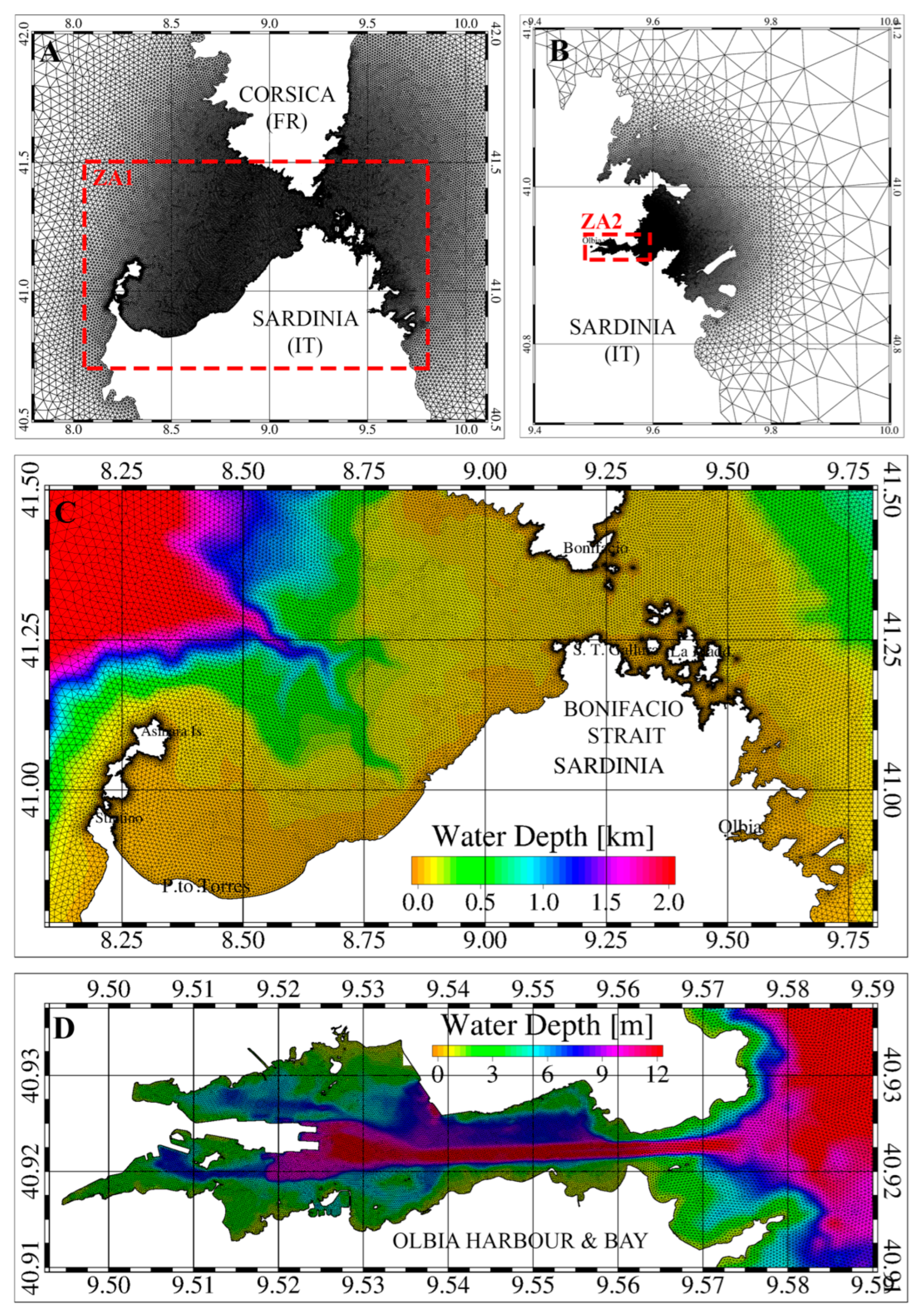
2. Projects and Study Areas

The project SICOMAR plus (henceforth simply SICOMAR) focused on governance, sea safety technologies, integrated forecasting systems and services to enhance the navigation safety within the cross-border maritime space of the Pelagos Sanctuary, the main Protected Area of Importance for the Mediterranean (SPAMI). The Sanctuary extends eastward just south of the Tuscan Archipelago in the northern Tyrrhenian Sea and westward from the French port of Toulon to northern Sardinia, covering a total marine area of approximately 87,500 km2 in the western Mediterranean basin.
The Bonifacio Strait, part of the Sanctuary, was one of the study areas of the project. It is located between Sardinia and Corsica and bounded by the Asinara Island, in the west, and the archipelagos of La Maddalena and Lavezzi, in the east. The Bonifacio Strait is characterised by hundreds of reefs and over seventy large and small islands on its eastern side. Depths range from 1,800 m in the Asinara Gulf to 70 m within the strait [16] (Figure 1).
The National Parks of La Maddalena Archipelago and of Asinara, the Natural Reserve of the Bonifacio Strait and the Bonifacio Strait International Marine Park are protected areas. In 2011, the Bonifacio Strait was recognized as a Particularly Sensitive Sea Area (PSSA) by the International Maritime Organization [17]. As for the entire Sanctuary, the Bonifacio Strait is characterised by an important natural heritage that faces considerable anthropogenic pressures with a high risk of at-sea accidents especially due to intense maritime traffic.
The project GEREMIA developed a port water quality management plan to mitigate the risks of wastewater and oil spill pollution and its potential impacts on the surrounding marine environment. It is an interdisciplinary and multi-partner research program covering different aspects related to the risk of pollution in harbour basins. Indeed, port waters are subjected to both endogenous pollution risks, associated with internal anthropic activities, and exogenous polluting wastewater entering the port.
The project focused on the port of Olbia, part of a two-port system in adjacent areas. The first is the port of Olbia, characterised by a shallow seabed (maximum 15 m), where the city of Olbia and its industrial area are located. The second is the port of Golfo Aranci, which mainly handles passenger ships and is adjacent to the Gulf of Olbia.
The port of Olbia encompasses the commercial port, handling Roll-on/Roll-off (Ro-Ro), cargos, passengers (over 3 million every year) [18] and cruise traffic, with an industrial segment (Port Cocciani) that hosts General Cargo, Multipurpose ships and Ro-Ro cargo operations. There is no petrochemical hub for the docking of oil and gas tankers. Furthermore, over 1.5 km2, mainly covering the central and eastern parts of the Port of Olbia, are utilised for intensive mussel farming, yielding over 5,000 tons of mussels per year [19], which are exported worldwide.
In the framework of these two projects, CNR implemented two operational oceanographic and oil spill prediction systems, enabling web access to oceanographic forecasts and pollutant hazard and risk assessments in the Bonifacio Strait and the port of Olbia, along with its adjoining Gulf which connects to the Tyrrhenian Sea.

3. The Operational Prediction System

3.1. The Oceanographic and Oil Spill Models

Both operational prediction systems are based on numerical ocean and oil spill models (also known as Particle Tracking Models; PTMs, version 7.5.84) and perform automated 3-day forecasts of water circulation and wave propagation in the areas of interest with high spatial resolution. Forecast products are provided, with a frequency of six hours, for surface currents, water temperature and wave height and direction. They are released daily through specially designed web interfaces. Oceanographic information combined with wind conditions constitute the inputs for the PTMs that are used to predict the transport of pollutants (such as oil and hydrocarbons) in the marine environment, including their dispersion and the potential risk of impacts on the surrounding coasts. The operational prediction system is subdivided into two sections: the public and the private one. The first one is open to the public and allows for the visualization of the ocean forecasting products and the latter, the private one, is restricted only to personnel in possession of a specific account and allows the user, through a Graphical User Interface (GUI), to set up and run oil spill transport simulations and to visualize the results.
A coupled ocean and wind wave model is the core of the operational prediction systems provided as a result of the SICOMAR and GEREMIA projects. It was applied, with dedicated implementation in the two study areas, to reproduce the surface circulation and wave fields induced by meteorological and marine forcing. It is based on the open-source code known as Shallow water Hydrodynamic Finite Element Model (SHYFEM, version 7.5.84) [20], a fully 3D hydrodynamic model based on the finite element method. The model resolves the primitive equations integrated over z-layers in their formulations with water levels and transports. It accounts for baroclinic, barotropic and atmospheric pressure gradients, wind drag and bottom friction, nonlinear advection, and vertical turbulent processes. The equation system for a single layer l reads as:
U l t + u l U l x + v l U l y f V l = g h l ζ x g h l ρ 0 x H l ζ ρ d z h l ρ 0 p a x + A H 2 U l x 2 + 2 U l y 2 + z K l h l U l z V l t + u l V l t + v l V l t + f U l = g h l ζ y g h l ρ 0 y H l ζ ρ d z h l ρ 0 p a y + A H 2 V l x 2 + 2 V l y 2 + z K l h l V l z ζ t + l U l x + l U l x = 0
where l indicates the vertical layer, ( U l ,   V l ) the horizontal transport (integrated velocities over one layer) components in x and y directions for each layer, ( u l , v l ) the velocity components, p a the atmospheric pressure, f the Coriolis parameter, g the gravitational constant, ζ the sea level, ρ 0 the standard water density, ρ the density anomaly, ρ = ρ + ρ 0 the water density, τ the internal stress term at the top and bottom of each layer, h l the layer thickness, H l the depth of the bottom of the layer, l and A H the horizontal eddy viscosity estimated following the Smagorinsky parameterization [21]. The GOTM (General Ocean Turbulence Model, release 4.0.0) turbulence closure model described in [22] was used for the computation of the vertical viscosity K l .
Momentum exchanges across the layers are accounted for by computing both the advective contribution and the vertical constituents of the diffusive terms z K l h l U l z a n d z K l h l V l z . Wind and bottom friction terms, corresponding to the boundary conditions of the stress terms ( τ x , τ y ), are defined as:
τ x s u r f a c e = c D ρ a w i x w i x 2 + w i y 2 τ x b o t t o m = c B ρ 0 u L u L 2 + v L 2 τ y s u r f a c e = c D ρ a w i y w i y 2 + w i y 2 τ y b o t t o m = c B ρ 0 v L u L 2 + v L 2
with c D as the wind drag coefficient, c B the bottom friction coefficient, ρ a the air density, ( w i x , w i y ) the wind velocity components and ( u L , v L ) the bottom velocity components. The hydrodynamic core is coupled in line with a module to solve the advection and diffusion of tracers and offline with the PTM [23,24,25] to simulate the transport of numerical particles caused by sea currents and winds. Specifically, hourly data of predicted sea currents and wind information are used to simulate the transport at the sea surface of spilled oil and an embedded weathering module is used to simulate the reduction of the oil volumes induced by evaporation. The PTM module solves, offline with respect to the hydrodynamic code, the advection and diffusion equation in a Lagrangian frame of reference:
x t = u a + u d y t = v a + v d
where u a , v a are the advective velocity components and u d , v d are the diffusive velocity components in x and y directions, respectively. The u d and v d components are computed using a random walk technique based on the Fischer study [26], with turbulent diffusion coefficients obtained using the Smagorinsky formula [27]. The components u a , v a are expressed as:
u a = α c u l + α w w i x v a = α c v l + α w w i y
where u l , v l are the horizontal velocities computed by the hydrodynamic model for the first vertical layer; w i x , w i y are the wind drift components; and α c and α w are the current transport and the wind transport factors.
A simplified weathering module accounting for the dynamical spreading and reduction of the oil mass due to evaporation processes is included. Specifically, the effect induced by mechanical spreading on the oil slick was reproduced based on the Fay theory [28] by extending, at the time of the release, the oil slick surface to the computed equilibrium area. The rate of oil mass lost due to evaporation processes was estimated using the formula derived from [29] without considering any effects on the particles’ surface transport due to the changing of the oil density. Furthermore, the module treats the oil slick as a floating body and the effect of density changes on sinking is also not considered. Indeed, sinking processes generally occur after two days from the release [30], which corresponds to the system prediction time lag. Therefore, the simulation of only the horizontal transport was considered as acceptable for the purpose of this application. We refer to [25] for a detailed description of the adopted methods.
The stranding of numerical particles was simulated as full entrapment on the coastline without the possibility to be re-entrained by the sea. Indeed, the rate of oil re-entering the sea is generally described by the half-life of the oil after it lands on the coast, as suggested by [31] and it is strongly related to the tidal amplitude and type of shore. Tyrrhenian and West Mediterranean sub-basins are both characterized by a microtidal regime with negligible tidal excursions (around 20 cm) and, consequently, by a very low possibility of re-entraining into the sea for stranded pollutants. Furthermore, shorelines in these types of coast are characterized by low reefs and isolated pocket beaches with half-life values generally greater than a few days, which is the time interval corresponding to the time lag of the forecasting procedure. Consequently, only small percentages of oil can re-enter the sea after deposition and therefore this phenomenon has been neglected. We refer to [23] for a detailed description of the adopted method and model parameters.
The model is also coupled with a spectral wave model, named Wind Wave Model (WWM, version 3) [32], which simulates the generation, propagation, and dissipation of wave motion and provides the momentum contribution derived from the kinetic energy dissipation processes that are typical of the wave motion. Specifically, a two-way coupling of wave and current models was realized through the wave-induced surface stresses, computed using the radiation stress theory of [33] as formulated by [34], accounting for 3D wave–current interaction. The communication between the ocean and wave modules is based on FIFO (First In First Out) files, which allow two processes to communicate during the runtime of each source code. We refer to [32] for a detailed description of the model equation system and coupling procedure.
The integrated numerical tools use finite element methods for the spatial integration of the equation systems with the computational domain defined through an unstructured computational mesh constituted by triangular elements with varying forms and spatial resolutions. Specifically, two finite element grids have been built to reproduce the morphological features of the two study areas with high details and resolution for shallow marine coastal areas (Figure 2). The dimensions of the elements varied between around 10 km in the outer part of the domains and up to 50 m for the coastal areas of the Bonifacio Strait and Gulf of Asinara and reducing to less than 20 m for the inner part of the Olbia harbour.
Atmospheric and oceanographic data provided by the European Centre for Medium-Range Weather Forecasts (ECMWF, www.ecmwf.int; accessed on 19 February 2024) and Copernicus Marine Service (CMEMS, www.copernicus.eu; accessed on 19 February 2024) [35] were used as model forcing and open boundary conditions.
The model application has been widely validated in previous studies [24,25] comparing simulation results with observations within calibration procedures that were iteratively estimating the model accuracy in predicting the surface transport caused by winds and currents in the areas. Specifically, the modelled sea current was compared to observed current at sea obtained by surface Lagrangian buoys (drifters) released in the area. The methodology is detailed in Quattrocchi [24] where they also showed that, after the calibration procedure, the best forecast gave a 24 h Trajectories Relative Error (TRE24) [36] ranging between 0.12 and 0.34. This corresponds to differences between numerical particles and drifters’ locations of 1.3 and 7.7 km, for a 24 h forecast.

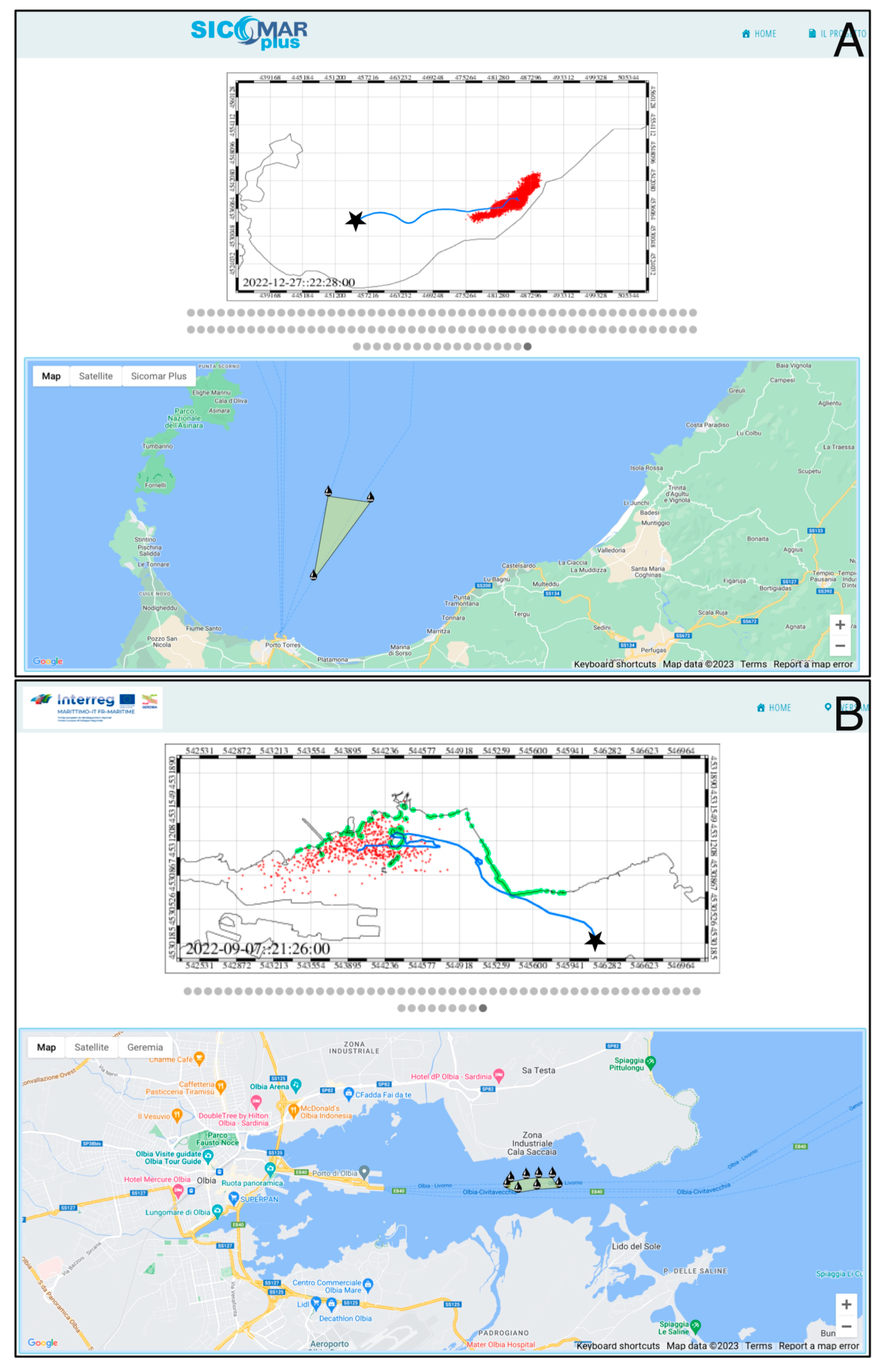
3.2. The Graphical Web Interfaces

The interactive graphical web interfaces are key elements of the operational numerical prediction systems because they are designed to reach out to the wider public of non-expert users that can benefit from these tools to effectively execute action plans at various intervention levels (e.g., marine spatial planning, prevention, or rapid environmental assessment). Specifically, two web platforms were developed, one for each project, featuring a comparable layout. They were built within the open-source software Content Management System (CMS) WordPress version 6.4.3, a server-side application composed of a back end to create and manage GUI contents and a front end for web users. CMS uses the PHP language and is installed on a LAMP server—Linux, Apache, MySQL, PHP (see references: Wikipedia; Html.it; Google Developers). The SICOMAR web platform (http://www.seaforecast.cnr.it/sicomarplus/; accessed on 19 February 2024)) operationally displays a 3-day forecast, with a 6-h frequency, of sea surface current, wave, sea surface temperature and Oil Stranding Time in the region of interest. Users can access the forecasts for the Bonifacio Strait or choose to view forecasts specifically for the Asinara region, the Archipelago of La Maddalena and the Gulf of Olbia. Additionally, they can access forecasts for the entire western coast of Sardinia, with the option to zoom in on the northern, central and southern areas. Users can also set up and run model simulations in on-demand mode. Indeed, users need to provide their own credentials to access the reserved area where, after having input some basic parameters, they can perform simulations to predict the surface transport of oil in northern Sardinia. Specifically, the date, the time, the amount of spilled hydrocarbon (m3) and the spill location must be defined to run the simulations. Specifically, the seeding location can be selected throughout the GUI by defining a single point or an area (by placing at least three markers on the map) where the quantity of oil will be released (see Figure 3A). The initial number of particles is fixed (around 104) in the case of single point sources whereas it is automatically computed in relation to the selected quantity of spilled oil and surface extension.
The simulation generates hourly maps of hydrocarbon distributions at the sea surface for the following three days, unless there is a stranding event which is highlighted in the map, which stops map generation before reaching three days. Considering the littorals vulnerability, Risk Rank maps are also generated at the end of the simulation and all these products remain accessible even on subsequent visits.
The operational web platform developed in GEREMIA (http://www.seaforecast.cnr.it/geremia//; accessed on 19 February 2024) daily displays a 3-day forecast, with a 6-h frequency, of sea surface current and Water Age in the port of Olbia and the entrance channel. Users can also choose to enlarge the forecast view for the dock and the channel. After accessing the platform and defining date, time, quantity and location of spilled hydrocarbons, users can perform simulations to predict the movement of pollutants within the port and the area of the gulf facing the canal (Figure 3B). The products of the simulation are available in the reserved area for future reference, like the previously described platform.
The effectiveness of both numerical prediction systems is demonstrated, and their operational products are described in the following subsections considering a set of simulations.

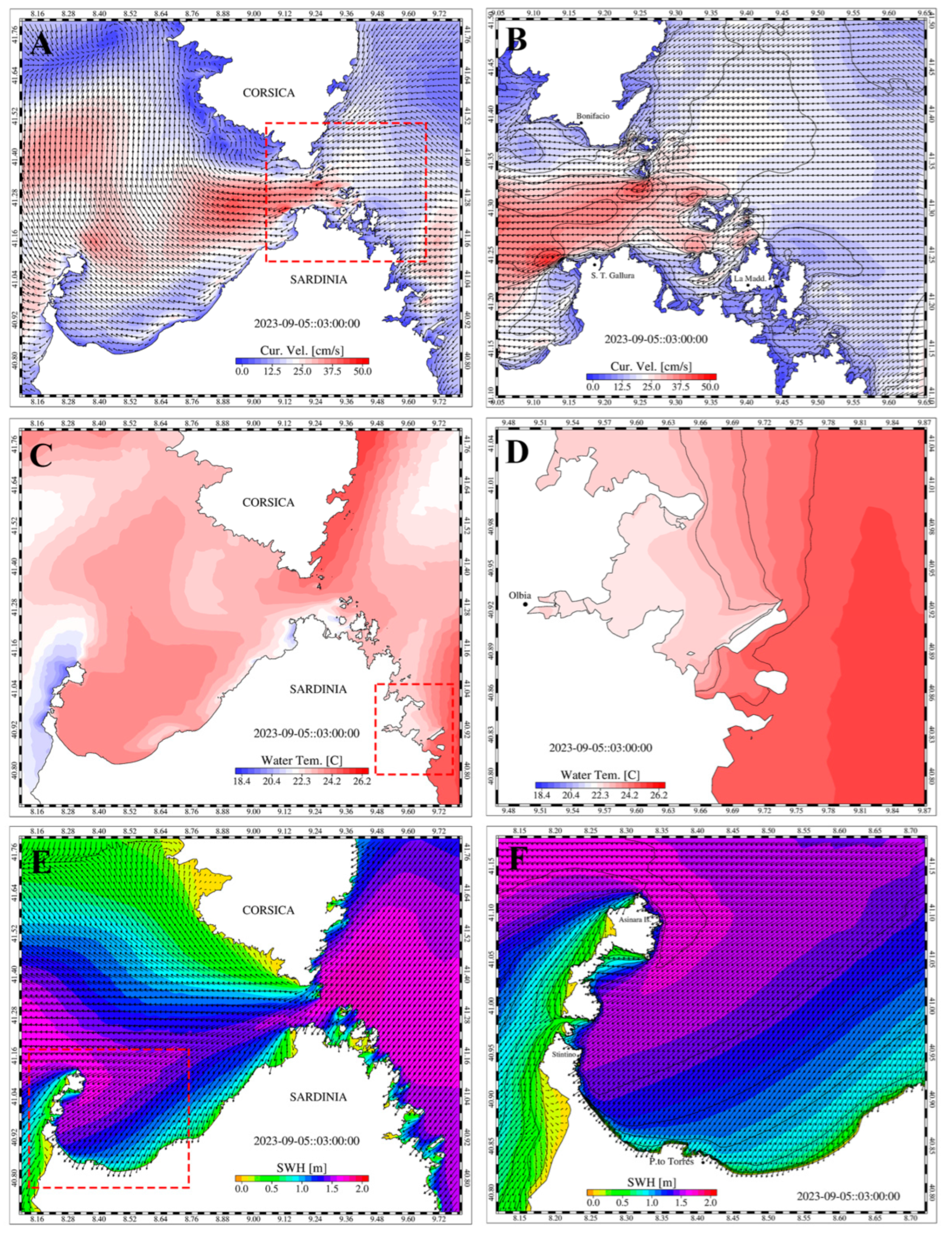
3.2.1. Simulations in Northern Sardinia

Users can access oceanographic forecasts for the Bonifacio Strait, encompassing information on sea surface currents, wave characteristics, and sea surface temperature. In Figure 4, we provide a representation of hourly data pertaining to surface currents (Figure 4A,B), temperature (Figure 4C,D) and wave height and direction (Panels E and F) predicted for a specific time interval marked by strong north-easterly winds (Grecale wind). The system offers various levels of zoom, including options for the La Maddalena Archipelago (Figure 4B), the Gulf of Olbia (Figure 4D) and the Gulf of Asinara (Figure 4F).
During this event, the intense Grecale wind led to a notable inflow of Tyrrhenian surface water masses through the Bonifacio Strait, resulting in westward currents exceeding 0.5 m/s (Figure 4A,B), which in turn transported warmer surface masses towards the Asinara Gulf (Figure 4C,D). The strong wind also generated high waves, reaching heights of up to 1.8 m, propagating westward and affecting a significant portion of the coastal area, particularly the Asinara Gulf (Figure 4E,F).
In addition to these oceanographic details, the operational systems also provide an estimate of the time a floating substance (e.g., spilled oil) takes to strand on the coast. This time, referred to as the Oil Stranding Time (ST) [24], is attributed to the entire sea domain of investigation as a function of the time it will take any potential oil leak to reach the coast (Figure 5A,B). Specifically, the coupled ocean and PTM models are used to compute the fate of numerical particles released every six hours over the whole domain, from the first day of forecasting to the following 48 h. The obtained results, accounting for the transport processes caused by the wind, sea current and waves, provide an estimate of the time required by such particles to reach the coastline. Daily maps of ST are operationally provided with daily frequency. The ST serves as a proxy for the threat that maritime traffic poses to this area. Indeed, where ST is less than 6 h (red areas) it indicates that the time for intervention, in case of a maritime accident, is quite short. In Figure 5, the Stranding Time was calculated under two distinct meteorological and marine conditions. In Figure 5A illustrates the ST derived during an intense north-east windstorm, which induced a westward surface current (as depicted in Figure 4). The resulting distribution exhibits its lowest values on the leeward sides of all islands and along coastlines facing eastward. In In Figure 5B, ST is computed during a moderate windstorm event from the north-west (mistral wind) which promotes a southward and eastward surface flow. This current configuration shapes the distribution of stranding times, with the lowest values occurring along coastlines facing westward.
The numerical prediction system can also provide Risk Rank maps. The risk computation results from the linear interaction between anthropogenic hazards (stranding events) and the in situ vulnerability on the base of geomorphological features. The vulnerability of the littoral is here related to the slope, geology of rocks and grain size features that can reduce or amplify the negative effects of any potential pollutants stranding on the coast [37,38,39]. Specific examples of Risk Rank maps can be found in a dedicated work by Quattrocchi [24].

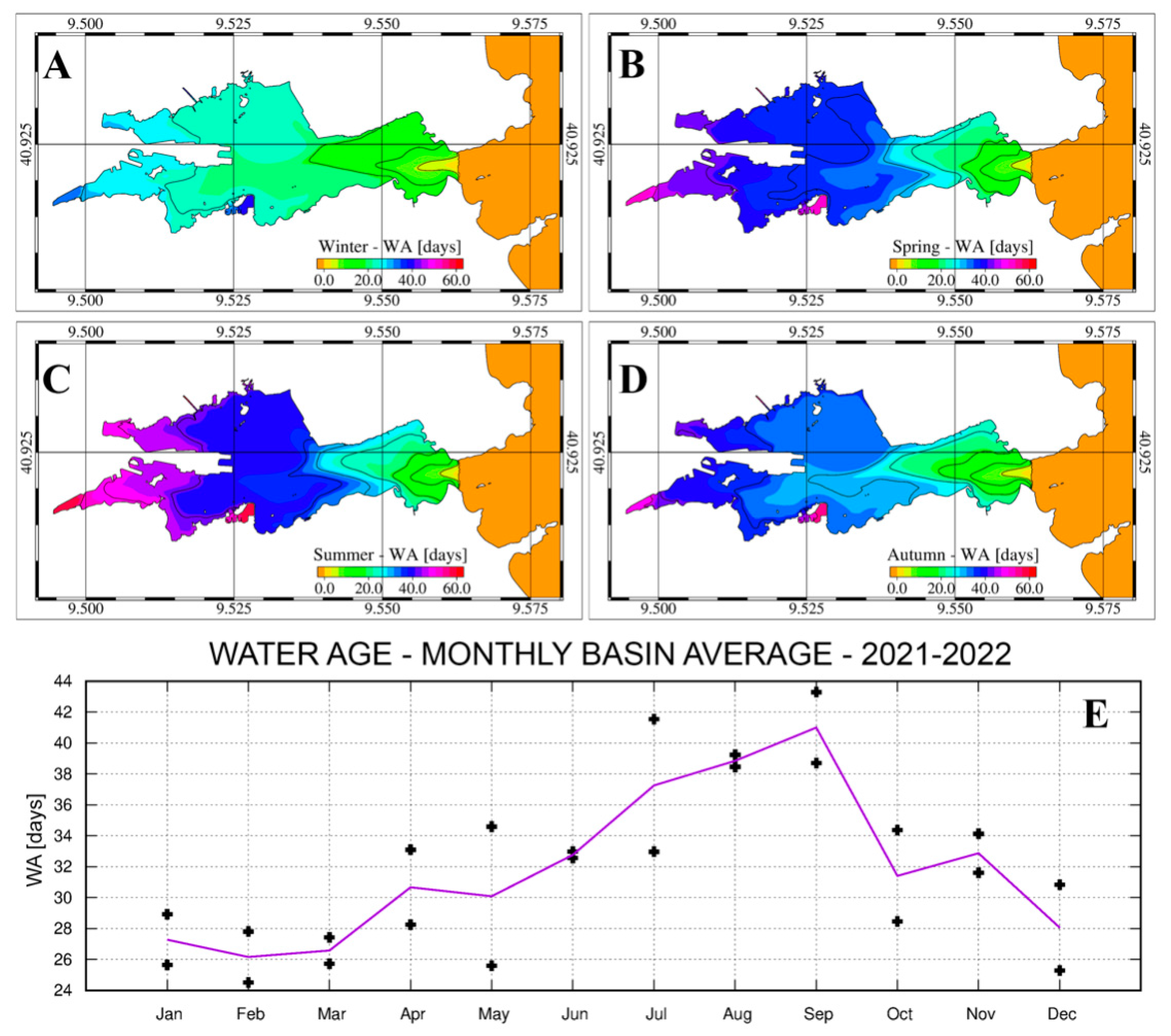
3.2.2. Simulations in the Port of Olbia

Users can access forecasts of sea surface currents, including the tidal effects, for the port of Olbia and its entrance channel. Two predominant scenarios are depicted in Figure 6, resulting from the influence of intense Mistral wind events during the winter season (Figure 6A) and during the summer when water circulation is primarily influenced by the low tidal forces and diurnal breezes (Figure 6B). The representation of surface circulation, generated daily by the ocean forecasting system, underscores the meteorological contribution to modulating surface circulation within the harbour.
The prediction systems also provide the Water Age (WA), a diagnostic variable used to quantify the efficiency of water renewal and used as a proxy for hazard assessment due to pollution. The procedure for WA estimation was proposed by Viero [40], enabling an innovative approach for the assessment of port water renewal capacity. Specifically, the adopted method involves the use of the SHYFEM ocean model to simulate, in a Eulerian frame of reference, the transport of passive tracers induced by the computed currents, with the concentration increasing, at each calculation step, by an amount corresponding to the calculation step itself for the waters within the harbour while, for external waters, the concentration is always set to be zero. This method allows for the calculation of the variability of temporal scales of transport under varying meteorological and marine conditions. Within the GEREMIA project, the calculation of Water Age was carried out in an operational mode to provide daily maps of potential risk for the accumulation of pollutants if released within the harbour. In Figure 6, the spatial distribution of the WA is shown for the same time intervals as those examined for the surface circulation, corresponding to an intense mistral event during the winter season (Figure 6B) and to a summer period when tide primarily influences local circulation and flushing features (Figure 6D). WA distributions vary between the two scenarios, with lower values occurring when intense water circulation promotes efficient exchanges through the inlet (Figure 6B). In both scenarios, the highest values, indicating the potential entrapment of water masses and pollutants, are located within the inner coves of the bay where, in summer, WA values exceeding 60 days were observed (Figure 6D).
A hazard pollution assessment for the port of Olbia has been also set up for port management authorities and stakeholders who can benefit from planning future interventions aimed at enhancing the environmental quality of the areas of concern. A two-year simulation (2021–2022) was performed using wind, atmospheric pressure and tides as forcing factors and the results processed to obtain monthly, seasonal and yearly evaluation of the bay water flushing efficiency. The two years, 2021 and 2022, have been selected as being representative of the recent days’ climatological features of the western Mediterranean basin. Specifically, yearly means and standard deviations of the wind speed computed from the CORDEX dataset (https://cordex.org/domains/region-12-mediterranean; accessed on 19 February 2024) for a location in front of the Gulf of Lions indicated that the meteorological features of both years were in line with the trend observed during the last decade. Figure 7 shows four seasonal maps (Figure 7A–D) where values range from a few hours near the mouth of the Gulf of Olbia connecting the harbour to the adjacent gulf to values exceeding 70 days in the two western inlets. WA increases from west to east, indicating a decrease in water renewal capacity in the western areas of the harbour. The seasonal values form a positive gradient from west to east, with minimum values at the entrance and along the navigable channel, and maximum values in the two internal basins, with higher values in the southern sub-basin.
Figure 7E depicts the monthly trend of the mean WA calculated for the entire basin, which varies depending on the characteristics of water circulation throughout the year. The mean values obtained from the two years of simulation indicate a decrease in water renewal capacity in the harbour during the spring and summer months, with mean WA values roughly ranging from 30 to 40 days, and an increase during the autumn and winter months, with basin average values between roughly 20 and 30 days.

4. Conclusions

Maritime safety and protection of the marine environment are common concerns for world coastal regions. These aspects require significant attention, particularly due to their economic implications on tourism, commerce and ecosystem management [41]. Marine basins that exhibit a strong environmental value along with heavy maritime traffic receive heightened attention. The Mediterranean region exemplifies this, with numerous areas in both the western and eastern basins serving as gateways to three continents. With a population of more than 150 million people, which doubles during the summer months [42], the Mediterranean accounts for more than 30% of the world’s maritime traffic volume, making it a crucial connection point between the Indian and Atlantic oceans. Additionally, the region boasts significant environmental and historical wealth [43].
Sardinia, located in the western Mediterranean, is an island renowned for its touristic presence and its remarkable coastal environmental wealth. The Bonifacio Strait and the port of Olbia hold strategic importance as access points to both Sardinia and southern Corsica, a primary gateway for tourists and goods. Cargo, tanker, ferry and cruise vessels traverse these marine areas. Therefore, these areas possess economic and environmental significance to Sardinia and should be preserved in the perspective of sustainable development. These factors led to their selection as areas of interest in the SICOMAR and GEREMIA projects.
In the framework of these two projects, two operational numerical prediction systems for pollution assessment, based on oceanographic and oil spill modelling, were implemented at CNR. These systems use leading coastal ocean models including high spatial resolution, calibration procedures and the best available European meteorological and marine products to pose boundary and surface forcing conditions (i.e., ECMWF and Copernicus Marine Service). The prediction system also includes ad hoc implementation of two web platforms, providing daily free access to 3-day ocean forecast and hazard and risk assessment products, after a free subscription. Fishermen, yachtsmen, seafarers and those working at sea, as well as emergency management entities like the Coast Guard, port authorities and the Italian Navy will be the primary beneficiaries of these tools and related products. Both systems are characterised by operational and on-demand functioning modes; the latter allows the user to perform pollutant transport simulations in the areas of interest.
Concerning the SICOMAR project, the products include the 3-day forecasting of the sea surface temperature, wave direction and height, current speed and direction (currently extended to the entire western coast of Sardinia), Oil Stranding Time and Risk Rank maps for the entire region, with the ability to zoom in on the Bonifacio Strait and the Gulf of Asinara. These products will support stakeholders to plan and manage any at-sea activities enhancing safety and reducing potential hazards derived by unexpected accidents. About the GEREMIA project, the operational products include the 3-day prediction of speed and direction of surface currents and Water Age within the port of Olbia and the surrounding gulf system. These products provide insights into the renewal times of water within the port under real meteorological conditions, a proxy for hazard assessment in case of maritime accidents, when relevant volumes of hydrocarbons may disperse in port water with significant implications for the touristic and economic sectors (e.g., bathing and aquaculture).
Over the past few decades, similar operational numerical systems have been developed in various world coastal regions, including the Mediterranean Sea. However, public and private entities are still engaged in research and development activities with the aim of improving the accuracy of the oceanographic and pollutant transport predictions [24,44,45,46,47]. The two presented numerical systems provide advances in their high resolution in space that can resolve coastal and port areas, their accuracy evaluation based on observed sea surface transport, the operational products for hazard and risk assessment (i.e., Oil Stranding Time, Risk Rank maps and Water Age) and the operational and on-demand web platform implementations used to help the work of stakeholders like local authorities and their communities. These innovations are meant to satisfy the needs of the European authorities engaged with reducing anthropogenic effects on the maritime environment, including in the port area [48].
Most of the products already provided after this work will find further applications in marine traffic management and marine safety extending, for instance, to coastal navigation and customized sea water monitoring. Indeed, the use of weather-marine forecasts to determine navigation routes has long been practiced, particularly in open sea navigation [49], while the integration of in situ observations and numerical model applications is expected to enhance the management of the marine space, especially port areas, e.g., [15]. There, excessive nutrient inputs, often nitrogen or phosphorus, can lead to their accumulation over time, resulting in excessive algal growth and oxygen depletion, thus deteriorating the ecological status of the waters.

Author Contributions

Conceptualization, A.C., S.S., G.Q. and A.R.; Data curation, A.R.; Formal analysis, A.C., S.S. and G.Q.; Funding acquisition, A.C. and S.S.; Investigation, A.C., S.S., G.Q., R.S., A.P. (Andrea Pes), A.S., M.S., A.P. (Angelo Perilli) and A.R.; Methodology, A.R.; Project administration, A.C. and S.S.; Software, A.P. (Andrea Pes); Supervision, A.C., S.S. and A.R.; Validation, A.C.; Visualization, A.P. (Andrea Pes); Writing—original draft, A.C., S.S. and A.R.; Writing—review & editing, A.C., S.S. and A.R. All authors have read and agreed to the published version of the manuscript.

Funding

This research was partially funded by the two 2014–2020—P.C. Interreg Italia-Francia “Marittimo” projects, SICOMAR plus (Sistema transfrontaliero per la sicurezza in mare Contro i rischi della navigazione e per la salvaguardia dell’ambiente MARino; prot. AOO IAMC CNR n. 0006682 of 09/07/2018 and prot. IAS CNR Oristano n. 0001156/2018 of 12/12/2018) and GEREMIA (Gestione dei reflui per il miglioramento delle acque portuali; prot. AOO IAMC CNR n. 0007075 of 17/07/2018 and prot. IAS CNR Oristano n. 0005055/2019 of 01/08/2019).

Institutional Review Board Statement

Not applicable.

Informed Consent Statement

Not applicable.

Data Availability Statement

Availability of Lagrangian data at SEANOE. https://doi.org/10.17882/90537; accessed on 19 February 2024. Availability of CTD data at SEANOE; accessed on 19 February 2024. The authors do not have permission to share current meter data from the port of Olbia.

Acknowledgments

The authors wish to thank the captain and crew of the CNR R/V G. DALLAPORTA for their support during the cruises in the areas of study. Special thanks to C.F. (CP) Paolo Bianca of the Coast Guard of Olbia for his support. The authors thank the Centro Operativo per la Meteorologia of the Italian Aeronautiaca Militare for furnishing meteorological forcing data. The work described here has been partially funded by the two 2014–2020 EU Program Interreg Italy–France “Maritime” projects, SICOMAR plus (SIstema transfrontaliero per la sicurezza in mare COntro i rischi della navigazione e per la salvaguardia dell’ambiente MARino) and GEREMIA (Gestione dei reflui per il miglioramento delle acque portuali).

Conflicts of Interest

The authors declare no conflicts of interest. The funders had no role in the design of the study; in the collection, analyses, or interpretation of data; in the writing of the manuscript; or in the decision to publish the results.

References

  1. Campana, I.; Angeletti, D.; Crosti, R.; Luperini, C.; Ruvolo, A.; Alessandrini, A.; Arcangeli, A. Seasonal characterisation of maritime traffic and the relationship with cetacean presence in the Western Mediterranean Sea. Mar. Pollut. Bull. 2017, 115, 282–291. [Google Scholar] [CrossRef] [PubMed]
  2. REMPEC. Study on Trends and Outlook of Marine Pollution from Ships and Activities and of Maritime Traffic and Offshore Activities in the Mediterranean, Floriana. Funded by the Mediterranean Trust Fund of the UNEP/MAP-Barcelona Convention. 2021; 182p. Available online: https://www.rempec.org/en/knowledge–centre/online-catalogue/studyontrends2022.pdf (accessed on 15 January 2024).
  3. UNEP/MAP. 2017 Mediterranean Quality Status Report (MED QSR). UNEP/MAP Tech. Rep. 2019, 539. Available online: https://wedocs.unep.org/handle/20.500.11822/31217 (accessed on 15 January 2024).
  4. Sakellariadou, F. Maritime pollutants in shipping and commercial European ports based on relevant physical and biogeochemical environmental parameters. Pure Appl. Chem. IUPAC Tech. Rep. 2015, 87, 1151–1166. [Google Scholar] [CrossRef]
  5. Abdulla, A.; Linden, O. (Eds.) Maritime Traffic Effects on Biodiversity in the Mediterranean Sea: Review of Impacts, Priority Areas and Mitigation Measures; IUCN Centre for Mediterranean Cooperation: Malaga, Spain, 2008; 184p, Available online: https://portals.iucn.org/library/sites/library/files/documents/2008-042-1.pdf (accessed on 15 January 2024).
  6. Coll, M.; Piroddi, C.; Albouy, C.; Ben Rais Lasram, F.; Cheung, W.W.L.; Christensen, V.; Karpouzi, V.S.; Guilhaumon, F.; Mouillot, D.; Paleczny, M.; et al. The Mediterranean Sea under siege: Spatial overlap between marine biodiversity, cumulative threats and marine reserves. Glob. Ecol. Biogeogr. 2012, 21, 465–480. [Google Scholar] [CrossRef]
  7. García-Revillo, M.G. Shipping, marine environmental protection and alien invasive species. In Maritime Safety and Environmental Protection in Europe. Multiple Layers in Regulation and Compliance; MARSAFENET, Ribeiro, M.C., Molenaar, E.J., Eds.; Marsafenet: Porto-Utrecht, The Netherlands, 2015; Volume 4, pp. 23–54. ISBN 978-989-20-5774-3. Available online: https://www.isgi.cnr.it/pubblications-it/marsafenet-open-access-publications/ (accessed on 19 February 2024).
  8. Pennino, M.G.; Pérez Roda, M.A.; Pierce, G.J.; Rotta, A. Effects of vessel traffic on relative abundance and behaviour of cetaceans: The case of the bottlenose dolphins in the Archipelago de La Maddalena, north-western Mediterranean sea. Hydrobiologia 2016, 776, 237–248. [Google Scholar] [CrossRef]
  9. Ritter, F.; Panigada, S. Chapter 28—Collisions of Vessels With Cetaceans—The Underestimated Threat. In World Seas: An Environmental Evaluation, 2nd ed.; Sheppard, C., Ed.; Academic Press: Cambridge, MA, USA, 2019; pp. 531–547. [Google Scholar] [CrossRef]
  10. Tintoré, J.; Pinardi, N.; Álvarez-Fanjul, E.; Aguiar, E.; Álvarez-Berastegui, D.; Bajo, M.; Balbin, R.; Bozzano, R.; Nardelli, B.B.; Cardin, V.; et al. Challenges for Sustained Observing and Forecasting Systems in the Mediterranean Sea. Front. Mar. Sci. 2019, 6, 568. [Google Scholar] [CrossRef]
  11. Barker, C.H.; Kourafalou, V.H.; Beegle-Krause, C.; Boufadel, M.; Bourassa, M.A.; Buschang, S.G.; Androulidakis, Y.; Chassignet, E.P.; Dagestad, K.-F.; Danmeier, D.G.; et al. Progress in Operational Modeling in Support of Oil Spill Response. J. Mar. Sci. Eng. 2020, 8, 668. [Google Scholar] [CrossRef]
  12. Álvarez-Fanjul, E.; Aouf, L.; Arnaud, A.; Ayoub, N.; Aznar, R.; Babanin, A.; Bahurel, P.; Bernier, N.B.; Bertino, L.; Bidlot, J.; et al. Implementing Operational Ocean Monitoring and Forecasting Systems. In GOOS-275; Álvarez-Fanjul, E., Ciliberti, S., Bahurel, P., Eds.; GOOS/ETOOFS Publ.: Paris, France, 2022; 392p, Available online: https://www.mercator-ocean.eu/en/guide-etoofs/ (accessed on 19 February 2024).
  13. Nelson, J.R.; Grubesic, T.H.; Sim, L.; Rose, K.; Graham, J. Approach for assessing coastal vulnerability to oil spills for prevention and readiness using GIS and the Blowout and Spill Occurrence Model. Ocean Coast. Manag. 2015, 112, 1–11. [Google Scholar] [CrossRef]
  14. Fernández-Macho, J. Risk assessment for marine spills along European coastlines. Mar. Pollut. Bull. 2016, 113, 200–210. [Google Scholar] [CrossRef]
  15. Ribotti, A.; Antognarelli, F.; Cucco, A.; Falcieri, M.F.; Fazioli, L.; Ferrarin, C.; Olita, A.; Oliva, G.; Pes, A.; Quattrocchi, G.; et al. An Operational Marine Oil Spill Forecasting Tool for the Management of Emergencies in the Italian Seas. J. Mar. Sci. Eng. 2019, 7, 1. [Google Scholar] [CrossRef]
  16. Chiocci, F.L.; Budillon, F.; Ceramicola, F.; Gamberi, F.; Orrù, P. Atlante dei Lineamenti di Pericolosità Geologica dei Mari Italiani—Risultati del Progetto MaGIC; CNR, Ed.; CNR Publ.: Rome, Italy, 2021; pp. 262–341. [Google Scholar]
  17. IMO. Resolution MEPC.204(62) adopted on 15 July 2011—Designation of the Strait of Bonifacio as a Particularly Sensitive Sea Area; MEPC 62/24/Add.1, Annex 22; IMO Publ.: London, UK, 2011; pp. 1–21. Available online: https://wwwcdn.imo.org/localresources/en/KnowledgeCentre/IndexofIMOResolutions/MEPCDocuments/MEPC.204(62).pdf (accessed on 19 February 2024).
  18. Port Authority. Available online: https://www.adspmaredisardegna.it/olbia/ (accessed on 15 January 2024).
  19. Viale, I.; Olla, G.; Salati, F. Acquacoltura in Sardegna: Tradizioni, Innovazione, Sapori e Ambiente. Agenzia Laore Sardegna: Cagliari, Italy, 2016; 52p, Available online: https://www.sardegnaagricoltura.it/documenti/14_43_20160616142206.pdf (accessed on 19 February 2024).
  20. Umgiesser, G.; Canu, D.M.; Cucco, A.; Solidoro, C. A finite element model for the Venice Lagoon. Development, set up, calibration and validation. J. Mar. Syst. 2004, 51, 123–145. [Google Scholar] [CrossRef]
  21. Blumberg, A.; Mellor, G.L.A. Description of a three-dimensional coastal ocean circulation model. In Three-Dimensional Coastal Ocean Models; Heaps, N.S., Ed.; American Geophysical Union: Washington, DC, USA, 1987; Volume 4, pp. 1–16. [Google Scholar]
  22. Burchard, H.; Petersen, O. Models of turbulence in the marine environment—A comparative study of two-equation turbulence models. J. Mar. Syst. 1999, 21, 29–53. [Google Scholar] [CrossRef]
  23. Cucco, A.; Sinerchia, M.; Ribotti, A.; Olita, A.; Fazioli, L.; Perilli, A.; Sorgente, B.; Borghini, M.; Schroeder, K.; Sorgente, R. A high-resolution real-time forecasting system for predicting the fate of oil spills in the Strait of Bonifacio (western Mediterranean Sea). Mar. Pollut. Bull. 2012, 64, 1186–1200. [Google Scholar] [CrossRef] [PubMed]
  24. Quattrocchi, G.; Simeone, S.; Pes, A.; Sorgente, R.; Ribotti, A.; Cucco, A. An Operational Numerical System for Oil Stranding Risk Assessment in a High-Density Vessel Traffic Area. Front. Mar. Sci. 2021, 8, 585396. [Google Scholar] [CrossRef]
  25. Cucco, A.; Quattrocchi, G.; Brambilla, W.; Navone, A.; Panzalis, P.; Simeone, S. The Management of the Beach-Cast Seagrass Wracks—A Numerical Modelling Approach. J. Mar. Sci. Eng. 2020, 8, 873. [Google Scholar] [CrossRef]
  26. Fischer, H.B.; List, J.E.; Koh, C.R.; Imberger, J.; Brooks, N.H. Mixing in Inland and Coastal Waters; Academic Press: Cambridge, MA, USA, 1979; 483p. [Google Scholar] [CrossRef]
  27. Smagorinsky, J. Some historical remarks on the use of non-linear viscosities. In Large Eddy Simulation of Complex Engineering and Geophysical Flows; Galperin, B., Orszag, S.A., Eds.; Cambridge University Press: Cambridge, UK, 1993; Volume 1, pp. 3–36. [Google Scholar]
  28. Fay, J.A. Physical Processes in the Spread of Oil on a Water Surface. Int. Oil Spill Conf. 1971, 1, 463–467. [Google Scholar] [CrossRef]
  29. Mackay, D.; Paterson, S.; Trudel, K. A Mathematical Model of Oil-Spill Behavior; Department of Chemical and Applied Chemistry, University of Toronto: Toronto, ON, Canada, 1980; 39p. [Google Scholar]
  30. NOAA. ADIOS™ (Automated Data Inquiry for Oil Spills); User’s Manual. Hazardous Materials Response and Assessment Division; NOAA: Seattle, WA, USA, 1993; 50p.
  31. Torgrimson, G.M. The On-Scene Spill Model: A User’s Guide; Technical Report, Hazardous Materials Response Branch; National Oceanic and Atmospheric Administration: Seattle, WA, USA, 1980.
  32. Roland, A.; Cucco, A.; Ferrarin, C.; Hsu, T.-W.; Liau, J.-M.; Ou, S.-H.; Umgiesser, G.; Zanke, U. On the development and verification of a 2-D coupled wave-current model on unstructured meshes. J. Mar. Syst. 2009, 78, S244–S254. [Google Scholar] [CrossRef]
  33. Longuet-Higgins, M.S.; Stewart, R.W. Radiation stresses in water waves; a physical discussion, with applications. Deep-Sea Res. Oceanogr. Abstr. 1964, 11, 529–562. [Google Scholar] [CrossRef]
  34. Xia, H.; Xia, Z.; Zhu, L. Vertical variation in radiation stress and wave-induced current. Coast. Eng. 2004, 51, 309–321. [Google Scholar] [CrossRef]
  35. von Schuckmann, K.; Le Traon, P.-Y.; Smith, N.; Pascual, A.; Djavidnia, S.; Gattuso, J.-P.; Grégoire, M.; Aaboe, S.; Alari, V.; Alexander, B.E.; et al. Copernicus Marine Service Ocean State Report, Issue 5. J. Oper. Oceanogr. 2021, 14 (Suppl. S1), 1–185. [Google Scholar] [CrossRef]
  36. Cucco, A.; Quattrocchi, G.; Zecchetto, S. The role of temporal resolution in modelling the wind induced sea surface transport in coastal seas. J. Mar. Syst. 2019, 193, 46–58. [Google Scholar] [CrossRef]
  37. Gundlach, E.R.; Ruby, C.H.; Hayes, M.O.; Blount, A.E. The Urquiola oil spill, La Coruña, Spain: Impact and reaction on beaches and rocky coasts. Environ. Geol. 1978, 2, 131–143. [Google Scholar] [CrossRef]
  38. Wang, S.D.; Shen, Y.M.; Zheng, Y.H. Two-dimensional numerical simulation for transport and fate of oil spills in seas. Ocean Eng. 2005, 32, 1556–1571. [Google Scholar] [CrossRef]
  39. Grottoli, E.; Ciavola, P. The role of detailed geomorphic variability in the vulnerability assessment of potential oil spill events on mixed sand and gravel beaches: The cases of two Adriatic sites. Front. Earth Sci. 2019, 7, 242. [Google Scholar] [CrossRef]
  40. Viero, D.P.; Defina, A. Water age, exposure time, and local flushing time in semi-enclosed, tidal basins with negligible freshwater inflow. J. Mar. Syst. 2016, 156, 16–29. [Google Scholar] [CrossRef]
  41. Gautier, P. Maritime safety and environmental protection in Europe: A role for international courts and tribunals? In Maritime Safety and Environmental Protection in Europe. Multiple Layers in Regulation and Compliance; MARSAFENET, Ribeiro, M.C., Molenaar, E.J., Eds.; Marsafenet: Porto-Utrecht, The Netherlands, 2015; Volume 4, pp. 261–290. ISBN 978-989-20-5774-3. Available online: https://www.isgi.cnr.it/pubblications-it/marsafenet-open-access-publications/ (accessed on 19 February 2024).
  42. UNEP/MAP. Available online: https://www.unep.org/unepmap/resources/factsheets/blue-economy (accessed on 15 January 2024).
  43. EMSA. SAFEMED V Project 2022–2028. Available online: https://www.emsa.europa.eu/neighbours/safemed-v.html (accessed on 15 January 2024).
  44. Petihakis, G.; Triantafyllou, G.; Tsiaras, K.; Korres, G.; Pollani, A.; Hoteit, I. Eastern Mediterranean biogeochemical flux model—Simulations of the pelagic ecosystem. Ocean Sci. 2009, 5, 29–46. [Google Scholar] [CrossRef]
  45. Grifoll, M.; Jordà, G.; Espino, M.; Romo, J.; García-Sotillo, M. A management system for accidental water pollution risk in a harbour: The Barcelona case study. J. Mar. Syst. 2011, 88, 60–73. [Google Scholar] [CrossRef]
  46. Trotta, F.; Fenu, E.; Pinardi, N.; Bruciaferri, D.; Giacomelli, L.; Federico, I.; Coppini, G. A Structured and Unstructured grid Relocatable ocean platform for Forecasting (SURF). Deep Sea Res. Part II Top. Stud. Oceanogr. 2016, 133, 54–75. [Google Scholar] [CrossRef]
  47. Zodiatis, G.; Lardner, R.; Alves, T.M.; Krestenitis, Y.; Perivoliotis, L.; Sofianos, S.; Spanoudaki, K. Oil spill forecasting (prediction). J. Mar. Res. 2017, 75, 923–953. Available online: https://elischolar.library.yale.edu/journal_of_marine_research/453 (accessed on 19 February 2024). [CrossRef]
  48. Gurning, R.O.S.; Tangkau, D.I. The Analysis of the Conceptual Framework of Green Port Implementation in Indonesia Using Circular Economy: The Case Study of Benoa Public and Fishing Terminals. Sustainability 2022, 14, 6083. [Google Scholar] [CrossRef]
  49. Mannarini, G.; Turrisi, G.; D’Anca, A.; Scalas, M.; Pinardi, N.; Coppini, G.; Palermo, F.; Carluccio, I.; Scuro, M.; Cretì, S.; et al. VISIR: Technological infrastructure of an operational service for safe and efficient navigation in the Mediterranean Sea. Nat. Hazards Earth Syst. Sci. 2016, 16, 1791–1806. [Google Scholar] [CrossRef]
Figure 1. The two domains of the modelling systems developed in the framework of the two projects: in (A) the Bonifacio Strait and the Gulf of Asinara, and in (B) the Port of Olbia.
Jmse 12 00380 g001
Figure 2. The computational meshes adopted by the ocean prediction systems. (A,C) depict the geometry and bathymetric details of the numerical mesh for the Bonifacio Strait areas (ZA1 in (A)) implemented for the SICOMAR prediction system. In (B,D), the details of the numerical mesh for the Gulf of Olbia (ZA2 in (B)) adopted for the GEREMIA prediction system are reported.
Jmse 12 00380 g002
Figure 3. Two sketches of the operational simulations of oil spill transport in the Bonifacio Strait (A) and in the Gulf of Olbia (B) using the SICOMAR (A) and GEREMIA (B) web interfaces. Initial positions of the spills are indicated by green areas in the geographical maps and by the black stars in the results plots, blue lines indicate the mean trajectories followed by numerical particles (red dots) and green lines highlight the impacted traits of coast. Grey dots indicate the number of simulated half-hours from the pollutants’ release with red ones referring to the visualized plot.
Jmse 12 00380 g003
Figure 4. Examples of the operational products from the SICOMAR ocean forecasting systems. Sea surface currents (A,B), temperature (C,D) and wave height and direction (E,F) computed during an intense Gregale wind event (from the north-east) in winter 2023. (C,D,F) refer to magnification areas indicated by red boxes.
Jmse 12 00380 g004
Figure 5. Examples of operational products from SICOMAR ocean forecasting systems. The Stranding Time calculated for the Bonifacio Strait during an intense windstorm event from the north-east (A) and under a moderate wind from the north-west (B).
Jmse 12 00380 g005
Figure 6. Examples of operational products from GEREMIA ocean forecasting systems. Sea surface currents and water age distribution computed for the Olbia harbour during an intense mistral windstorm event in winter 2023 (A,B) and in summer 2023 in the absence of intense wind (C,D).
Jmse 12 00380 g006
Figure 7. Seasonal means of vertically averaged water age computed from the two-year (2021–2022) model simulation results (AD). Monthly variability of the basin average WA computed for 2021 and 2022 (black crosses in (E)) and for the entire two-year period (purple line in (E)).
Jmse 12 00380 g007
Disclaimer/Publisher’s Note: The statements, opinions and data contained in all publications are solely those of the individual author(s) and contributor(s) and not of MDPI and/or the editor(s). MDPI and/or the editor(s) disclaim responsibility for any injury to people or property resulting from any ideas, methods, instructions or products referred to in the content.

