
Distribution and Environmental Impact of Expanded Polystyrene Buoys from Korean Aquaculture Farms


Abstract
1. Introduction
2. Materials and Methods
2.1. Buoy-Tracking Model
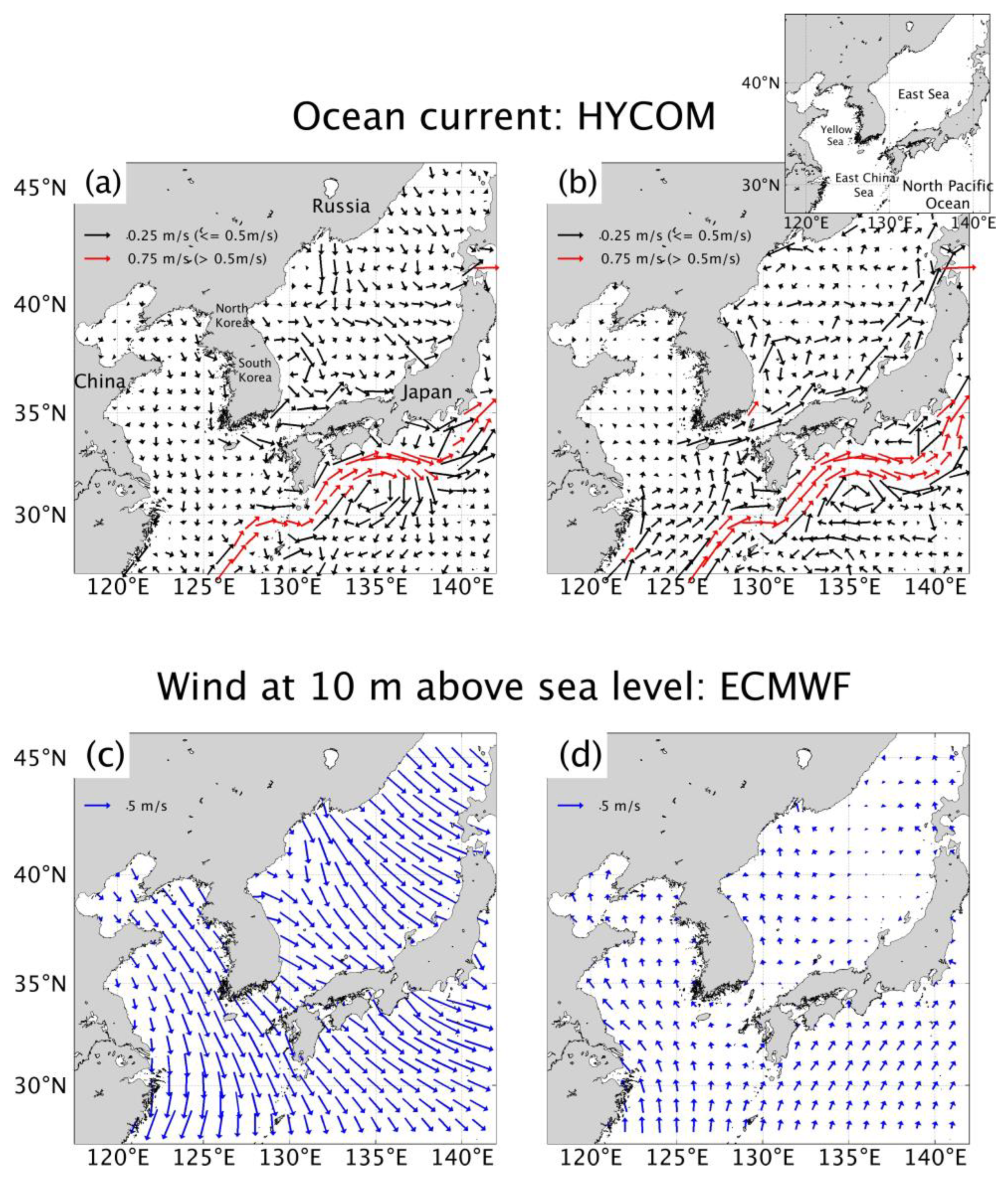
2.2. Input Data
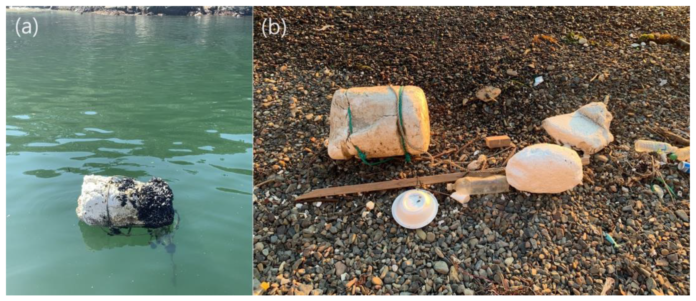
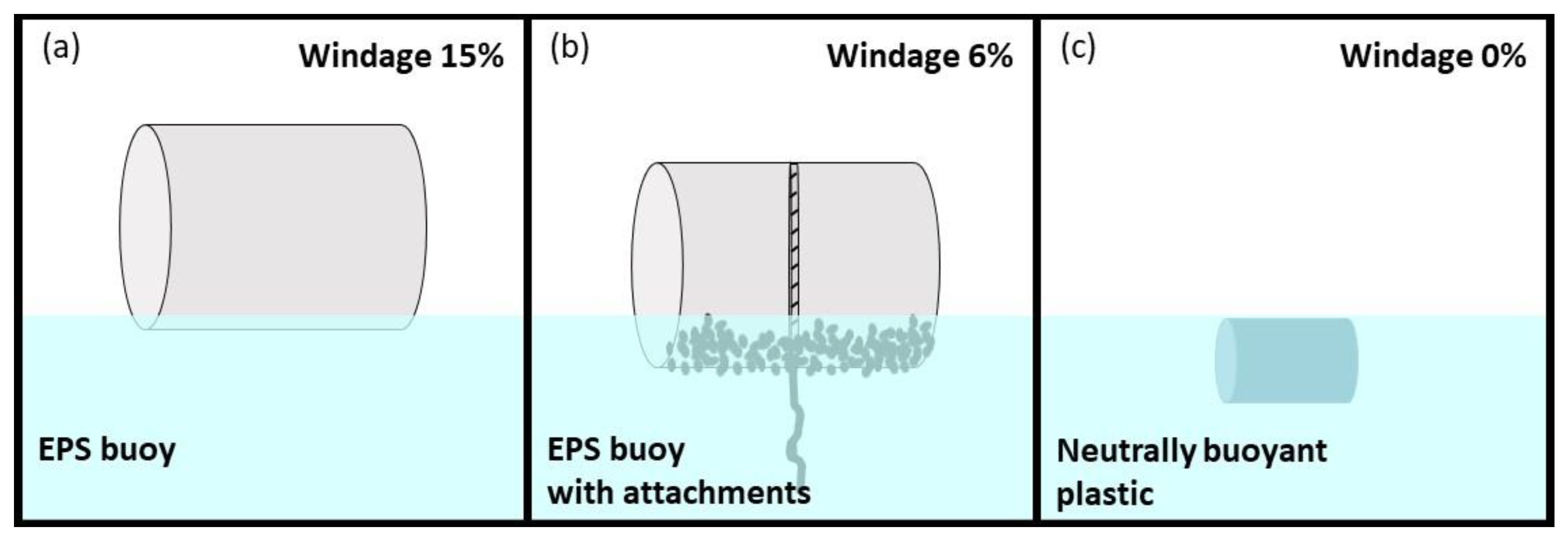
2.3. Experiments
2.4. Probability Function
3. Result and Discussion
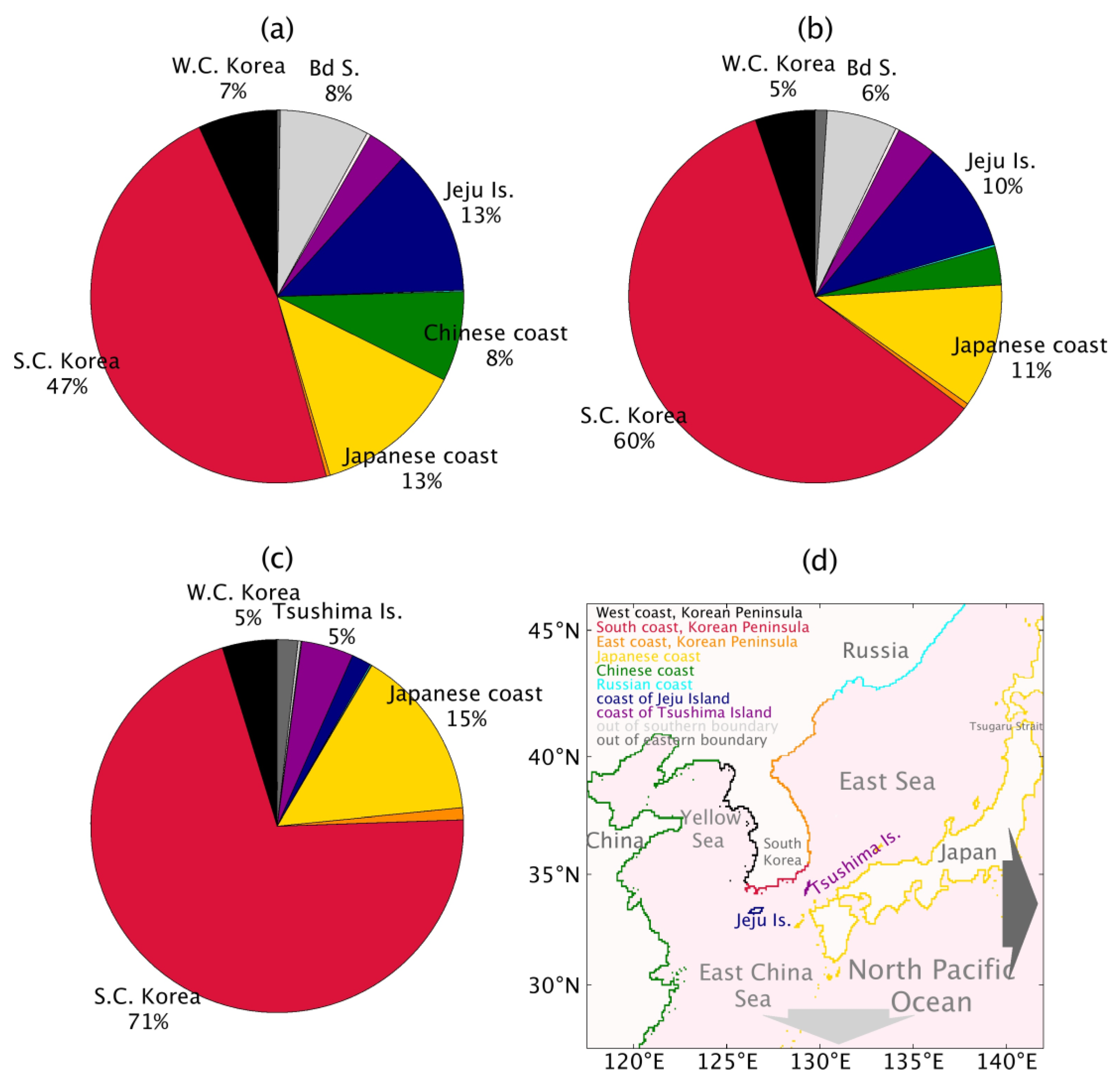
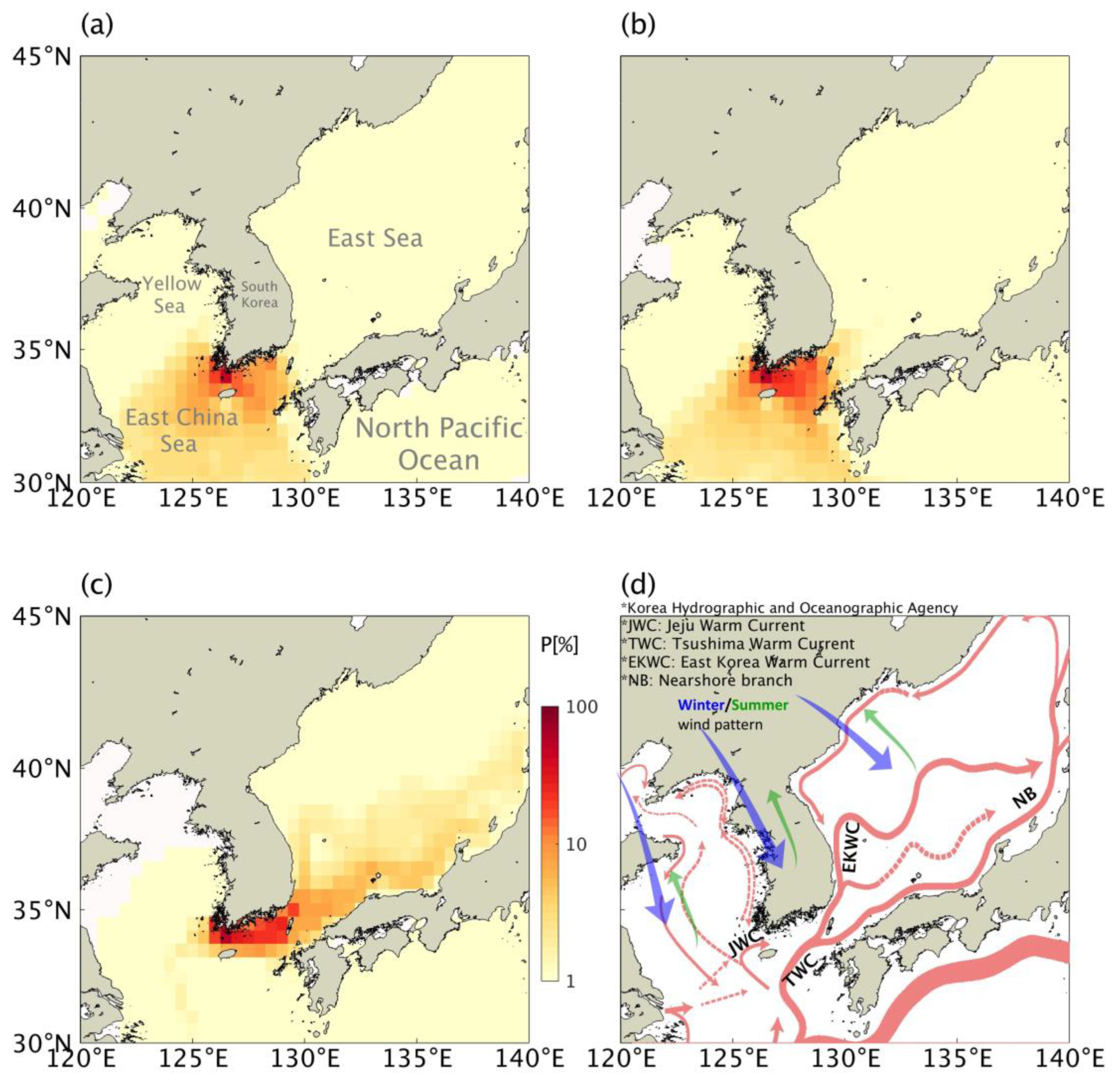
3.1. Pathways
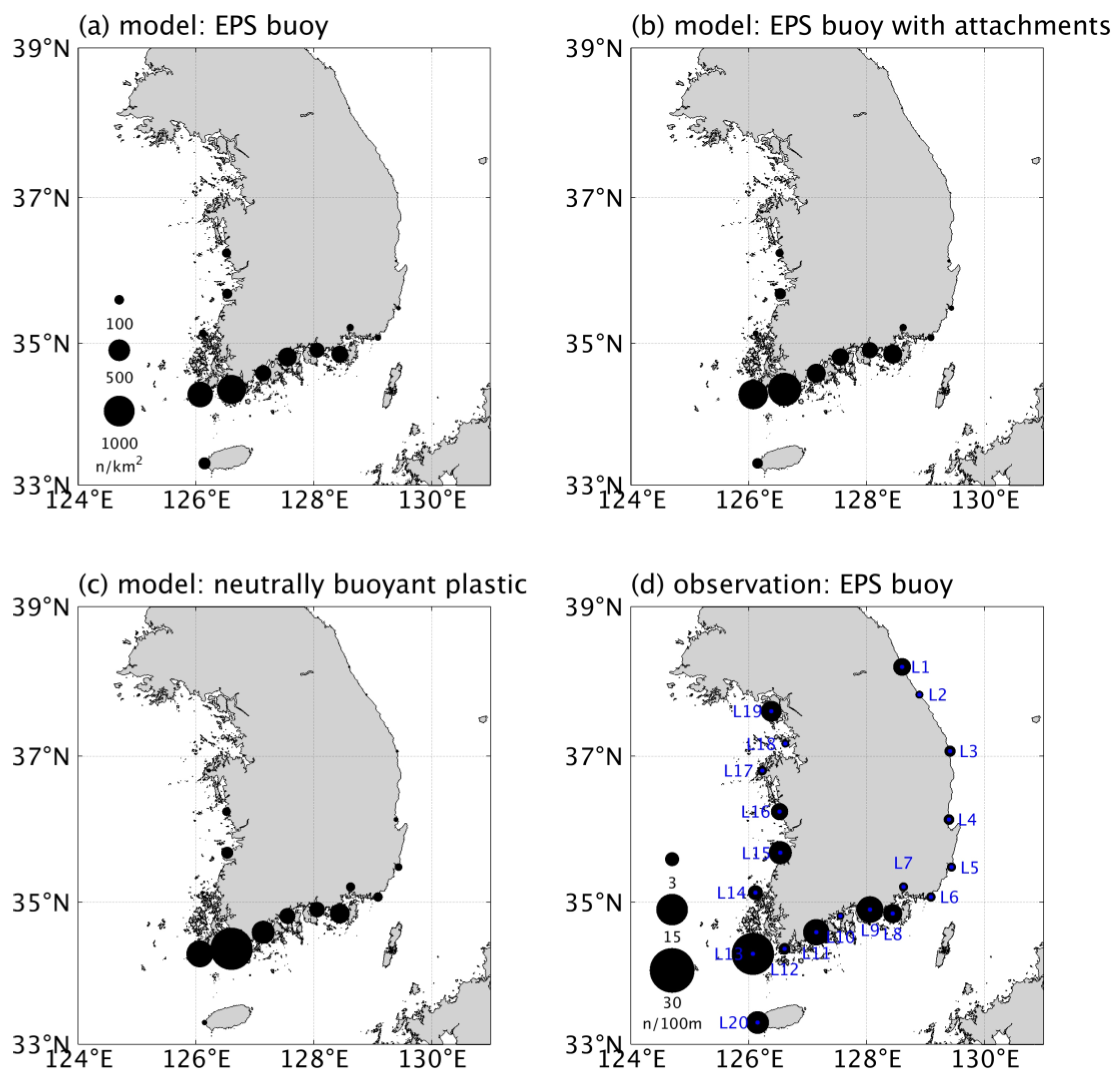
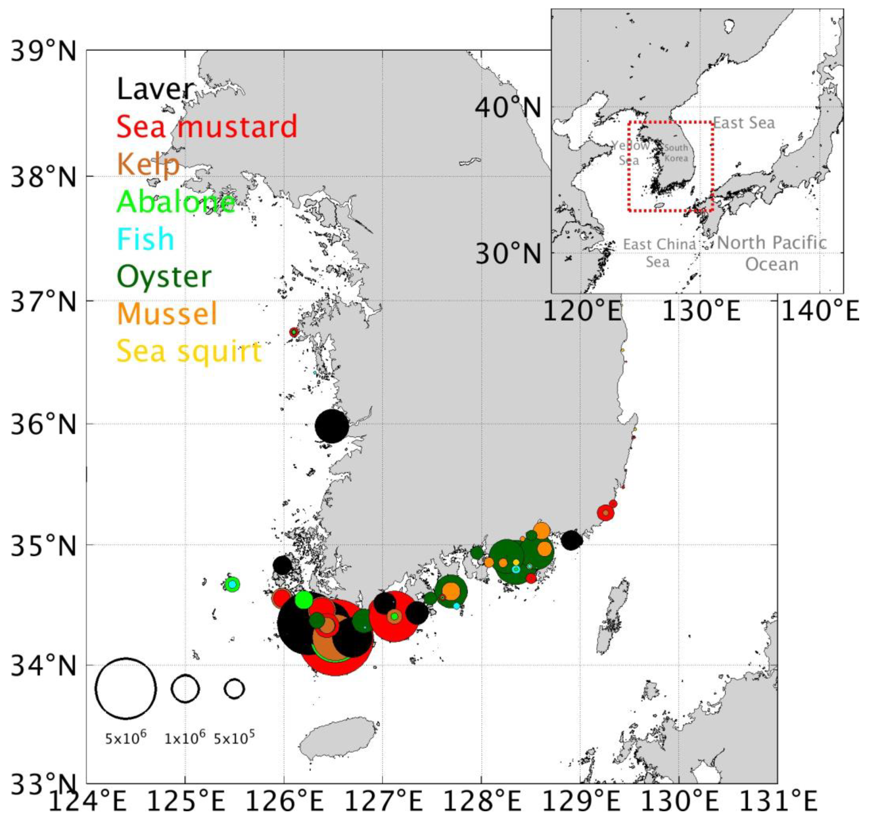
3.2. Coastal Accumulation on the Coast of South Korea: Comparison with Observations
3.3. Destination
4. Conclusions
Author Contributions
Funding
Institutional Review Board Statement
Informed Consent Statement
Data Availability Statement
Acknowledgments
Conflicts of Interest
References
- MOF. Establishment of Integrated Management System for Waste Aquaculture Styrofoam Buoy; MOF: Sejong-si, Republic of Korea, 2018. (In Korean)
- KOEM. National Coastal Litter Monitoring; KOEM: Seoul, Republic of Korea, 2021. (In Korean) [Google Scholar]
- Jang, S.W.; Kim, D.H.; Seong, K.T.; Chung, Y.H.; Yoon, H.J. Analysis of floating debris behaviour in the Nakdong River basin of the southern Korean peninsula using satellite location tracking buoys. Mar. Pollut. Bull. 2014, 88, 275–283. [Google Scholar] [CrossRef]
- Song, Y.K.; Hong, S.H.; Eo, S.; Shim, W.J. The fragmentation of Nano-and microplastic particles from thermoplastics accelerated by simulated-sunlight-mediated photooxidation. Environ. Pollut. 2022, 311, 119847. [Google Scholar] [CrossRef]
- Eo, S.; Hong, S.H.; Song, Y.K.; Lee, J.; Lee, J.; Shim, W.J. Abundance, composition, and distribution of microplastics larger than 20 μm in sand beaches of South Korea. Environ. Pollut. 2018, 238, 894–902. [Google Scholar] [CrossRef]
- Hong, S.; Lee, J.; Kang, D.; Choi, H.W.; Ko, S.H. Quantities, composition, and sources of beach debris in Korea from the results of nationwide monitoring. Mar. Pollut. Bull. 2014, 84, 27–34. [Google Scholar] [CrossRef] [PubMed]
- Lee, J.; Jang, Y.C.; Hong, S.Y.; Lee, J.S.; Kim, K.S.; Choi, H.J.; Hong, S. A study on the annual inflow and its control of Styrofoam buoy debris in oyster aquaculture farm in Gyeongnam, Korea. Ocean Policy Res. 2016, 31, 55–79. [Google Scholar]
- Iskandar, M.R.; Park, Y.G.; Kim, K.; Jin, H.; Seo, S.; Kim, Y.H. Tracking the pumice rafts from the Fukutoku-Okanoba submarine volcano with Satellites and a Lagrangian Particles trajectory model. Mar. Pollut. Bull. 2023, 193, 115254. [Google Scholar] [CrossRef]
- Maximenko, N.; Hafner, J.; Kamachi, M.; MacFadyen, A. Numerical simulations of debris drift from the Great Japan Tsunami of 2011 and their verification with observational reports. Mar. Pollut. Bull. 2018, 132, 5–25. [Google Scholar] [CrossRef]
- Murray, C.C.; Maximenko, N.; Lippiatt, S. The influx of marine debris from the Great Japan Tsunami of 2011 to North American shorelines. Mar. Pollut. Bull. 2018, 132, 26–32. [Google Scholar] [CrossRef]
- Seo, S.; Park, Y.G. Destination of floating plastic debris released from ten major rivers around the Korean Peninsula. Environ. Int. 2020, 138, 105655. [Google Scholar] [CrossRef]
- Seo, S.; Park, Y.G. Tracking a coastal wave buoy, lost from the southern coast of Jeju Island, using Lagrangian particle modeling. J. Mar. Sci. Eng. 2021, 9, 795. [Google Scholar] [CrossRef]
- Seo, S.; Park, Y.G.; Kim, K. Tracking flood debris using satellite-derived ocean color and particle-tracking modeling. Mar. Pollut. Bull. 2020, 161, 111828. [Google Scholar] [CrossRef]
- Yoon, J.H.; Kawano, S.; Igawa, S. Modeling of marine litter drift and beaching in the Japan Sea. Mar. Pollut. Bull. 2010, 60, 448–463. [Google Scholar] [CrossRef]
- Dormand, J.R.; Prince, P.J. A family of embedded Runge-Kutta formulae. J. Comput. Appl. Math. 1980, 6, 19–26. [Google Scholar] [CrossRef]
- North, E.W.; Hood, R.R.; Chao, S.Y.; Sanford, L.P. Using a random displacement model to simulate turbulent particle motion in a baroclinic frontal zone: A new implementation scheme and model performance tests. J. Mar. Syst. 2006, 60, 365–380. [Google Scholar] [CrossRef]
- Smagorinsky, J. General circulation experiments with the primitive equations: I. The basic experiment. Mon. Weather Rev. 1963, 91, 99–164. [Google Scholar] [CrossRef]
- Iwasaki, S.; Isobe, A.; Kako, S.I.; Uchida, K.; Tokai, T. Fate of microplastics and mesoplastics carried by surface currents and wind waves: A numerical model approach in the Sea of Japan. Mar. Pollut. Bull. 2017, 121, 85–96. [Google Scholar] [CrossRef]
- Kwoun, C.H.; Cho, K.D.; Kim, D.S. A Numerical simulation for the circulation of sea water in the Southern Coastal Waters in Korea. J. Korean Sci. Mar. Environ. Eng. 2002, 5, 27–40. (In Korean) [Google Scholar]
- Egbert, G.D.; Erofeeva, S.Y. Efficient inverse modeling of barotropic ocean tides. J. Atmos. Ocean Technol. 2002, 19, 183–204. [Google Scholar] [CrossRef]
- Qian, W.; Lee, D.K. Seasonal march of Asian summer monsoon. Int. J. Climatol. 2000, 20, 1371–1386. [Google Scholar] [CrossRef]
- Rypina, I.I.; Jayne, S.R.; Yoshida, S.; Macdonald, A.M.; Buesseler, K. Drifter-based estimate of the 5 year dispersal of Fukushima-derived radionuclides. J. Geophys. Res. Oceans 2014, 119, 8177–8193. [Google Scholar] [CrossRef]
- Mao, Y.; Lin, F.; Fang, J.; Fang, J.; Li, J.; Du, M. Bivalve Production in China. In Goods and Services of Marine Bivalves; Springer: Cham, Switzerland, 2019; pp. 51–72. [Google Scholar]
- Chen, C.L.; Kuo, P.H.; Lee, T.C.; Liu, C.H. Snow lines on shorelines: Solving Styrofoam buoy marine debris from oyster culture in Taiwan. Ocean Coast. Manag. 2018, 165, 346–355. [Google Scholar] [CrossRef]
- Critchell, K.; Grech, A.; Schlaefer, J.; Andutta, F.P.; Lambrechts, J.; Wolanski, E.; Hamann, M. Modelling the fate of marine debris along a complex shoreline: Lessons from the Great Barrier Reef. Estuar. Coast. Shelf Sci. 2015, 167, 414–426. [Google Scholar] [CrossRef]
- Turner, A. Foamed polystyrene in the marine environment: Sources, additives, transport, behavior, and impacts. Environ. Sci. Technol. 2020, 54, 10411–10420. [Google Scholar] [CrossRef] [PubMed]
- Póvoa, A.A.; de Araújo, F.V.; Skinner, L.F. Macroorganisms fouled in marine anthropogenic litter (rafting) arround a tropical bay in the Southwest Atlantic. Mar. Pollut. Bull. 2022, 175, 113347. [Google Scholar] [CrossRef] [PubMed]
- Neumann, D.; Callies, U.; Matthies, M. Marine litter ensemble transport simulations in the southern North Sea. Mar. Pollut. Bull. 2014, 86, 219–228. [Google Scholar] [CrossRef] [PubMed]
- Mansui, J.; Molcard, A.; Ourmieres, Y. Modelling the transport and accumulation of floating marine debris in the Mediterranean basin. Mar. Pollut. Bull. 2015, 91, 249–257. [Google Scholar] [CrossRef] [PubMed]
- Allison, N.L.; Dale, A.; Turrell, W.R.; Aleynik, D.; Narayanaswamy, B.E. Simulating the distribution of beached litter on the northwest coast of Scotland. Front. Environ. Sci. 2022, 10, 940892. [Google Scholar] [CrossRef]
- Fazey, F.M.; Ryan, P.G. Biofouling on buoyant marine plastics: An experimental study into the effect of size on surface longevity. Environ. Pollut. 2016, 210, 354–360. [Google Scholar] [CrossRef]


Disclaimer/Publisher’s Note: The statements, opinions and data contained in all publications are solely those of the individual author(s) and contributor(s) and not of MDPI and/or the editor(s). MDPI and/or the editor(s) disclaim responsibility for any injury to people or property resulting from any ideas, methods, instructions or products referred to in the content. |
© 2024 by the authors. Licensee MDPI, Basel, Switzerland. This article is an open access article distributed under the terms and conditions of the Creative Commons Attribution (CC BY) license (https://creativecommons.org/licenses/by/4.0/).
Share and Cite
Seo, S.; Park, Y.-G. Distribution and Environmental Impact of Expanded Polystyrene Buoys from Korean Aquaculture Farms. J. Mar. Sci. Eng. 2024, 12, 256. https://doi.org/10.3390/jmse12020256
Seo S, Park Y-G. Distribution and Environmental Impact of Expanded Polystyrene Buoys from Korean Aquaculture Farms. Journal of Marine Science and Engineering. 2024; 12(2):256. https://doi.org/10.3390/jmse12020256
Chicago/Turabian StyleSeo, Seongbong, and Young-Gyu Park. 2024. "Distribution and Environmental Impact of Expanded Polystyrene Buoys from Korean Aquaculture Farms" Journal of Marine Science and Engineering 12, no. 2: 256. https://doi.org/10.3390/jmse12020256
APA StyleSeo, S., & Park, Y.-G. (2024). Distribution and Environmental Impact of Expanded Polystyrene Buoys from Korean Aquaculture Farms. Journal of Marine Science and Engineering, 12(2), 256. https://doi.org/10.3390/jmse12020256