1. Introduction
Coastal areas represent environments of particular significance from a risk perspective, due to both their natural functional dynamics and the intensive use that populations currently make of these spaces. Ecologically, the coastline can be defined as an ecotone; from a geographical standpoint, it can be seen as a boundary space, a land–sea interface, encompassing the geosphere, hydrosphere, and biosphere, with the added intensive involvement of human activity, or the anthroposphere [
1]. These concepts imply, by the transitional nature of their morphology and function, and their mixed character, complex spaces with significant challenges in maintaining equilibrium.
Global warming and its short- and long-term effects pose a significant threat to climate-related activities. In this context, the coastal strip as a whole is an especially fragile territory in the face of climate change, with consequences that are particularly noticeable, as accelerated morphological and functional changes are expected in these areas. Climate is a key factor in determining the potential and quality of coastal leisure activities, affecting both environmental comfort and the functioning of major risk processes impacting the coast, such as sea-level rise, coastal flooding, coastal erosion, storm damage, pest outbreaks, drought, and aquifer salinization.
The Mediterranean coast experiences both events typical of continental areas (droughts, floods, mass movements, seismic activity) and phenomena unique to coastal areas, driven by marine processes. Thus, coastal risk takes on identifiable characteristics, dependent on specific hazard and exposure factors, and plays a significant role in what Cutter [
2] identifies as a “risk place,” or similar notions proposed by Calvo [
3] and Olcina [
4]. The regulations governing coastal land use and spatial management measures make coastal risks definable as “territorial risks” [
5]. Coastal space, therefore, represents a relatively autonomous risk unit with a complex set of factors.
These risk processes directly affect coastal resources, such as beaches and coastal landscapes, impacting their functionality as leisure spaces. Therefore, the appeal of coastal areas is highly sensitive to the degradation of these spaces and any changes that create uncertainty about their use [
6]. Furthermore, the increase in Mediterranean temperatures alters marine thermodynamics and the living conditions of ecosystems, leading to changes in the spatial distribution of species, such as fish stocks. Changes may also occur in the movement dynamics of certain species, such as the frequent occurrence of jellyfish blooms, which are becoming an increasing problem in the Mediterranean [
6,
7]. The condition of coastal areas is critical for overall economic development, and any factor that disrupts their ecological balance represents a territorial threat. The coastline, depending on its well-being, directly impacts the population and much of the region’s economic structure, making it a strategic factor whose deterioration could lead to significant impacts.
Jellyfish are gelatinous marine organisms belonging to the Cnidaria phylum [
8]. Their typical lifespan is about eight months [
9], initially as polyps attached to substrates before developing into jellyfish. Their proliferation is irregular, sometimes resulting in blooms [
8,
10].
Pelagia noctiluca is the species that predominantly experiences this phenomenon in the western Mediterranean [
11]. As plankton, jellyfish are carried by ocean currents [
10,
12], sometimes reaching the coast driven by winds and tides [
13,
14]. Most of the scientific literature on jellyfish from previous years has focused on biological aspects of their proliferation [
8,
11,
15,
16,
17] or on biophysical aspects, such as the drift of these blooms toward the coasts [
14,
18].
Jellyfish swarms have been reaching much of the southern coast of Spain for decades [
19,
20,
21,
22]. Although the annual frequency of strandings is not regular, tourism and leisure activities on these beaches are sometimes significantly impacted [
23]. In the summers of 2015 and 2018, two peaks occurred, affecting a large portion of the Mediterranean coastline. This has raised concern and fear among local authorities and the tourism sector in the area.
The concept of hazard is defined by Ayala and Olcina [
24] as a natural or technological process that can cause harm to people, property, or the environment. The territorial approach to risk analysis [
2,
3,
4,
5] emphasizes the importance of the location of causative and receptor elements in risk evaluation, replacing the sectoral approach with a phenomenological one that views reality as integrated within the territory.
More specifically, Perles and Cantarero [
25] highlight the need to understand the spatial pattern of a hazardous event’s behavior. They propose structuring the spatial hazard pattern into causative areas, flow-transmitting lines or surfaces, and receptor areas for the process’s impacts. For a hazard to affect a receptor area, a transfer vector of matter and energy must exist to connect them, with the causative area positioned to allow this transfer. This approach guides the methodology used in this study to analyze the hazard posed by jellyfish swarms reaching different points along the coast.
Numerous studies focus on proposing predictive models for specific hazards, based on the concurrence of conditioning factors in space and time. This is particularly common in the prediction of mass movement risks. In this field, susceptibility maps are often developed by correlating the highest frequency of hazardous events in an area (signs of mobilization on slopes) with the presence of specific conditioning factors for mobilization. Cause–effect models allow the relative importance of each conditioning factor in hazard generation to be deduced, with corresponding weightings assigned [
26].
The technique of binomial logistic regression for predicting a region’s predisposition to a particular phenomenon has not been frequently used to analyze potential causative factors, as detailed inventories of jellyfish frequencies are not common. However, this methodology has been widely used in the analysis of risks of different etiologies, especially in cases where the independent and/or dependent variables include non-parametric data. Logistic regression has been extensively used, for example, in analyzing the risk of gravitational movements—a process that could be considered similar to our case in terms of the statistical nature of the resulting and predictive variables, as the key variable in predicting gravitational movement, such as lithology, is nominal. Similarly, the resulting variable—the presence or absence of signs of mobilization on land—is, like in our case, dichotomous, indicating the presence or absence of jellyfish. Numerous studies have applied univariate or multivariate logistic regression to various geomorphological hazards [
27,
28,
29,
30,
31,
32,
33,
34,
35,
36,
37,
38,
39].
Progress has been made in studying jellyfish from a risk analysis perspective. The numerous studies on jellyfish development and proliferation in southern Spain primarily focus on threat analysis, although the approach is largely spatial distribution pattern analysis, without specifically assessing the hazard posed by the process.
Research that does focus on the spatial and/or temporal behavior of swarms, and the search for conditioning factors, has provided insights. For instance, Bellido et al. [
18] explore the relationship between atmospheric indices and coastal swarm incidences, finding a connection between years of high jellyfish bloom occurrences and heavy winter and spring rainfall [
13,
18]. In Costa del Sol, Castro-Gutiérrez et al. [
14] relate jellyfish sightings to wind direction, noting that winds perpendicular to the coast have a greater influence in central and eastern Málaga, while parallel winds affect the western coast. Kogovsek et al. [
40] examine historical occurrences in the Adriatic Sea over the past 200 years, combined with environmental variables (temperature, salinity, pH, chlorophyll, dry weight of zooplankton, and major river discharges), concluding that the periodicity of bloom occurrences has shortened in recent decades, increasing the recurrence of jellyfish blooms. Likewise, Goy et al. [
15] state that, using a forecast model (climatic variables, temperature, rainfall, and atmospheric pressure),
Pelagia noctiluca periods can be predicted. Purcell et al. [
41] predict a progressive increase in jellyfish populations, particularly in East Asia, associated with human activities contributing to global warming, such as aquaculture and other structures that provide favorable habitats for jellyfish, or hydrological changes caused by dam construction that can alter salinity, promoting jellyfish proliferation. Records from the Station Zoologique at the Villefranche-sur-Mer Oceanographic Observatory contain data on years with and without
Pelagia noctiluca presence, indicating that during the 200-year period from 1785 to 1985, massive blooms of this species occurred with an approximate twelve-year periodicity.
In the specific case of Costa del Sol, studies by researchers at the Aula del Mar observe an increase in the frequency and magnitude of jellyfish occurrences on the Málaga coastline, suggesting a change in trend [
42]. Over the past decade, jellyfish blooms have been recorded in 2- to 4-year cycles, whereas previously, these cycles were expected to occur every 10–20 years [
43].
There exists a significant knowledge gap regarding the specific factors that determine the susceptibility of beaches to jellyfish arrivals, although previous studies have explored spatial and temporal patterns of jellyfish behavior and the factors influencing their distribution [
44,
45,
46,
47]. This article aims to address this gap by developing a predictive model based on binomial logistic regression, which will be used to generate hazard maps. The methodology involves using independent variables related to environmental and geomorphological characteristics, integrating these variables into a statistical analysis to better understand the conditions under which jellyfish swarms reach different points along the coast.
2. Materials and Methods
At this stage of research, the presence of underlying structural and circumstantial factors in each study unit is explored, which could influence the susceptibility of certain beaches to jellyfish landings. Various advanced statistical procedures for multivariate analysis, as well as specialized indices for spatial analysis of geographic data, have been employed.
To advance this analysis, the frequency of jellyfish occurrences is considered a dependent variable or a result of the interaction of a series of independent or predictive variables, as specified below. The goal is to determine which morphological and/or functional characteristics of the beach might act as causal agents influencing the likelihood of jellyfish landings.
The core methodological approach is designed to develop a strategy for identifying the beaches most susceptible to jellyfish outbreaks, thus guiding the responsible authorities in prioritizing mitigation and/or compensatory measures for affected areas. Therefore, the methodology has been designed to operate at a reduced scale, focused on the beach as the unit of analysis. This is because its function is to signal which beaches are at a greater risk. The initial step involves identifying the problematic episodes of jellyfish occurrences on the beaches under study; these occurrences are the dependent variable, characterized by temporal and spatial variability. In the next phase, independent variables that influence the level of impact and severity in the study area are defined. These independent variables are categorized into two fundamental types: structural variables, which pertain to the inherent characteristics of each beach, and circumstantial variables, which are external to each beach but could influence the frequency of jellyfish landings. These can be understood as determining and activating factors in the estimation of risk.
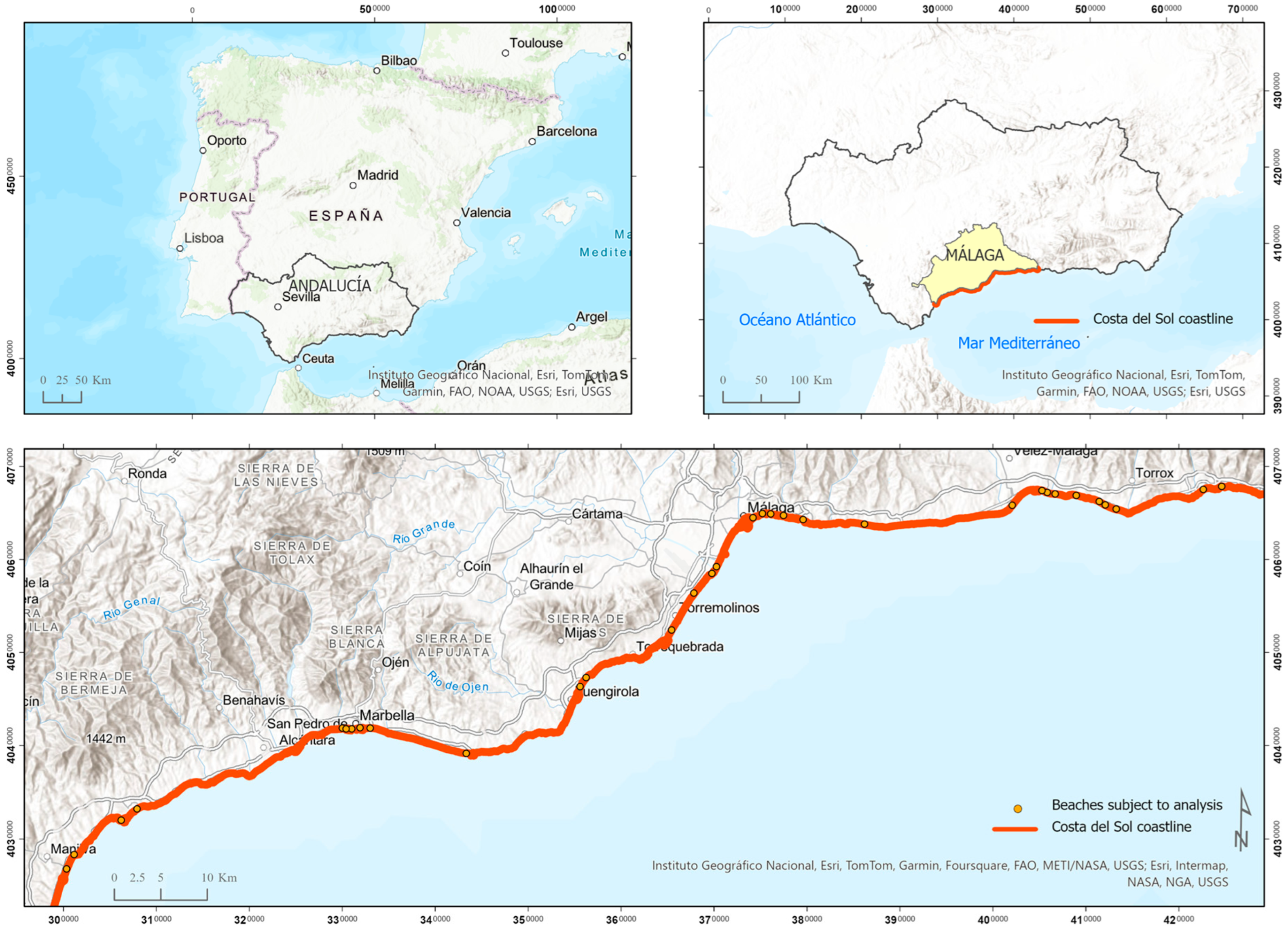
2.1. Study Area Selection
The selected study area for this research corresponds to various beaches along the coastline of the province of Málaga. Málaga is located in southern Spain, in the Andalusian region, and lies along the Mediterranean coast, comprising the so-called Costa del Sol.
This coastal strip, known as Costa del Sol, is bordered by the southern foothills of the Betic mountain ranges to the north and the Mediterranean Sea to the south. Its location between the sea and the mountains gives it unique characteristics in terms of landscape, settlement systems, and economic development, among other territorial features. This area is characterized by its strong association with the service sector, particularly tourism. The unit of analysis and representation is the beach, as it constitutes the minimum physiographic boundary for defining homogeneous morphological and coastal functional processes, making it an appropriate unit for interpreting susceptibility to jellyfish landings and identifying the causes that may explain the variation in impact.
A total of 32 beaches with diverse characteristics were selected based on criteria outlined in the beach guide published by the Ministry for Ecological Transition and the Demographic Challenge (MITECO) (
Figure 1). These beaches stretch over approximately 175 km along the Costa del Sol coastline. They are distributed across the coast with different morphological and functional features, ensuring diverse and comprehensive representation for statistical analysis.
2.2. Phase 1: Obtaining the Dependent Variable—Treatment of the Jellyfish Sighting Database
To analyze the susceptibility of various beaches to jellyfish landings, the first step undertaken was the processing and cleaning of raw data on this subject, available in the database compiled by Aula del Mar through the Infomedusa software application. This application’s primary purpose is to provide information on whether or not jellyfish are present on the beach. These data are used as the dependent or outcome variable for developing a predictive model of each beach’s likelihood of experiencing jellyfish landings. The temporal interval considered was the summer period from 2015 to 2020, and the data processing followed these steps:
Interpretation and classification of comments: Given that the data were provided in raw form, the first step involved systematically interpreting and filtering comments to discard those irrelevant to the study. Useful comments were quantified for each beach under study, considering one record per day and beach, as it was common to find multiple daily comments. In cases of contradictory comments (e.g., presence and absence of jellyfish reported for the same beach on the same day), priority was given to reports of jellyfish presence or to the most relevant observations.
Data standardization: To ensure comparability between beaches of varying sizes, the total number of jellyfish sightings was standardized relative to each beach’s length. This was performed using the following parameter: the number of days with jellyfish sightings per 100 meters of coastline. This approach avoids distortions in frequency and severity values caused by differences in beach size.
Classification of results into four intervals of risk severity: The intervals were determined using the mean () and standard deviation (σ) of the standardized data.
Integration of interpreted data into a designed matrix: The matrix compiled the standardized data, organizing them by beach and on a daily basis, while avoiding event duplication. This matrix includes information on the presence or absence of jellyfish, as well as potential conditioning factors to be completed in Phase 2.
Using this processed and standardized dataset, a cartography of jellyfish hazard levels was created, providing an overview of the susceptibility of beaches to jellyfish landings.
2.3. Phase 2: Obtaining the Independent Variables—Inventory of the Potentially Conditioning Factors of the Beach’s Increased Susceptibility to Jellyfish Arrivals
2.3.1. Phase 2a: Selection of Variables Related to Jellyfish Occurrence
First, a thorough investigation of the independent variables believed to be related to the increased occurrence of jellyfish in a specific location and time was conducted. This selection was based on a literature review and field and empirical analysis.
Subsequently, an assessment was made of the availability and capacity of the information sources to cover and provide data on these variables of interest, as well as their statistical reliability. Additionally, consultations were held with the Aula del Mar to select, based on the expertise of their technicians, the variables that were ultimately identified as potential causes of the recurrent presence of jellyfish on a beach.
The variables selected as potential determinants of the frequency of jellyfish landings (predictor or independent variables) have been grouped into two main types: structural variables, which are inherent characteristics of each beach, and circumstantial variables, which are external to the beach but may influence the frequency of jellyfish landings. Structural variables are stable over time and consistent across space, while circumstantial variables fluctuate over time. This classification, therefore, aligns with what we could identify as determinant and triggering factors in hazard estimation terminology.
Each beach, the working unit of this study, has been characterized based on a total of 12 structural variables and 9 circumstantial variables (
Figure 2).
As can be observed, the selected determining or structural factors related to each beach have been grouped into four categories:
Topographic features that define the vertical morphology of the beach.
Topographic features that define the horizontal morphology.
Substrate characteristics.
Degree of human intervention.
Meanwhile, circumstantial or situational factors have been grouped into two main categories:
In
Table 1, the independent variables included in this study are shown, indicating the type of variable (circumstantial or structural), the unit of analysis (if applicable), and the data source.
In the case of the variables that express circumstantial conditions potentially influencing the propensity of a beach to receive jellyfish, the raw data are presented with a daily frequency, making the systematization process particularly laborious. This phase has been supported by direct and indirect data sources, with the processing, treatment, and cartographic editing of data relying on various types of automated spatial analysis techniques, supported by automated cartographic instruments and Geographic Information Systems (GIS).
2.3.2. Phase 2b: Exploratory Analysis of Potential Factors Influencing a Beach’s Propensity to Receive Jellyfish
The hypothesis to be tested is whether the increased frequency of jellyfish arrivals at a particular beach is caused by structural or circumstantial factors in the surrounding environment. If an explanatory model for jellyfish propensity is confirmed, this model could be used to predict the risk at other beaches along the coast. The susceptibility of various beaches selected for this study is analyzed. The beach constitutes the basic physiographic unit of analysis and the subject for statistical examination.
The methodology is based on the application of multivariate logistic regression. This technique allows for comparing the jellyfish variable (presence or absence of jellyfish sightings in an area) with all the concurrent conditioning factors in the space, enabling the calculation of the weights assigned to each factor in the predictive equation.
The application of logistic regression allows for the analysis of variables with different statistical characteristics (continuous or categorical, with or without normal distribution), making it an ideal tool for this study. In this case, causal factors include variables with limited variability, dichotomous characteristics, and others that are discrete and widely variable.
The logistic regression model is used when attempting to predict the probability of a specific event occurring [
48]. It is a multivariate method that allows for the prediction of the presence or absence of a particular outcome based on a set of initial indicators. Binomial logistic regression deduces an equation that establishes the underlying mathematical relationship between a dependent dichotomous variable and a set of independent predictor variables. It accommodates variables of different natures and statistical characteristics (continuous or categorical, and with or without normal distribution).
In binomial logistic regression, the probability of a certain event can be expressed using the following equation (Equation (1)), where β0 is the intercept, and β1, β2, …, βk represent the coefficients corresponding to the independent variables X1, X2, …, Xk, respectively. In our study, these variables X1, X2, …, Xk represent environmental and ecological factors that may influence the likelihood of jellyfish presence, such as water temperature, ocean currents, and salinity. The coefficient β0 adjusts the probability when no factors are present, while the other coefficients (β1, β2, …, βk) indicate the relative influence of each factor on the probability of jellyfish occurrence. The equation calculates the probability (Pi) of jellyfish reaching the coast, and the odds ratio represents the likelihood of jellyfish presence versus absence.
The logistic regression has been applied in two iterations:
In the first iteration, the susceptibility factors included in Model B1 were introduced, using all predictor variables.
In a second iteration, a new regression model was generated by removing variables with lower statistical significance (Model B2) to determine if this restriction clarifies the statistical procedure and improves the results.
3. Results
The results have been organized into a database that correlates the presence or absence of jellyfish with the conditioning factors described in the methodology (both circumstantial and structural), with daily frequency from June to September over the period 2015–2020 for a preselected sample of beaches. Given the magnitude of the database, which contains 23,425 records and 1,423,599 data cells, the results are structured by variable, depending on the representational possibilities of each one. It is understood that it is the combination of all variables (both dependent and independent) and their interactions on each beach and day that yield the final outcomes.
3.1. Results of the Application of Binomial Logistic Regression
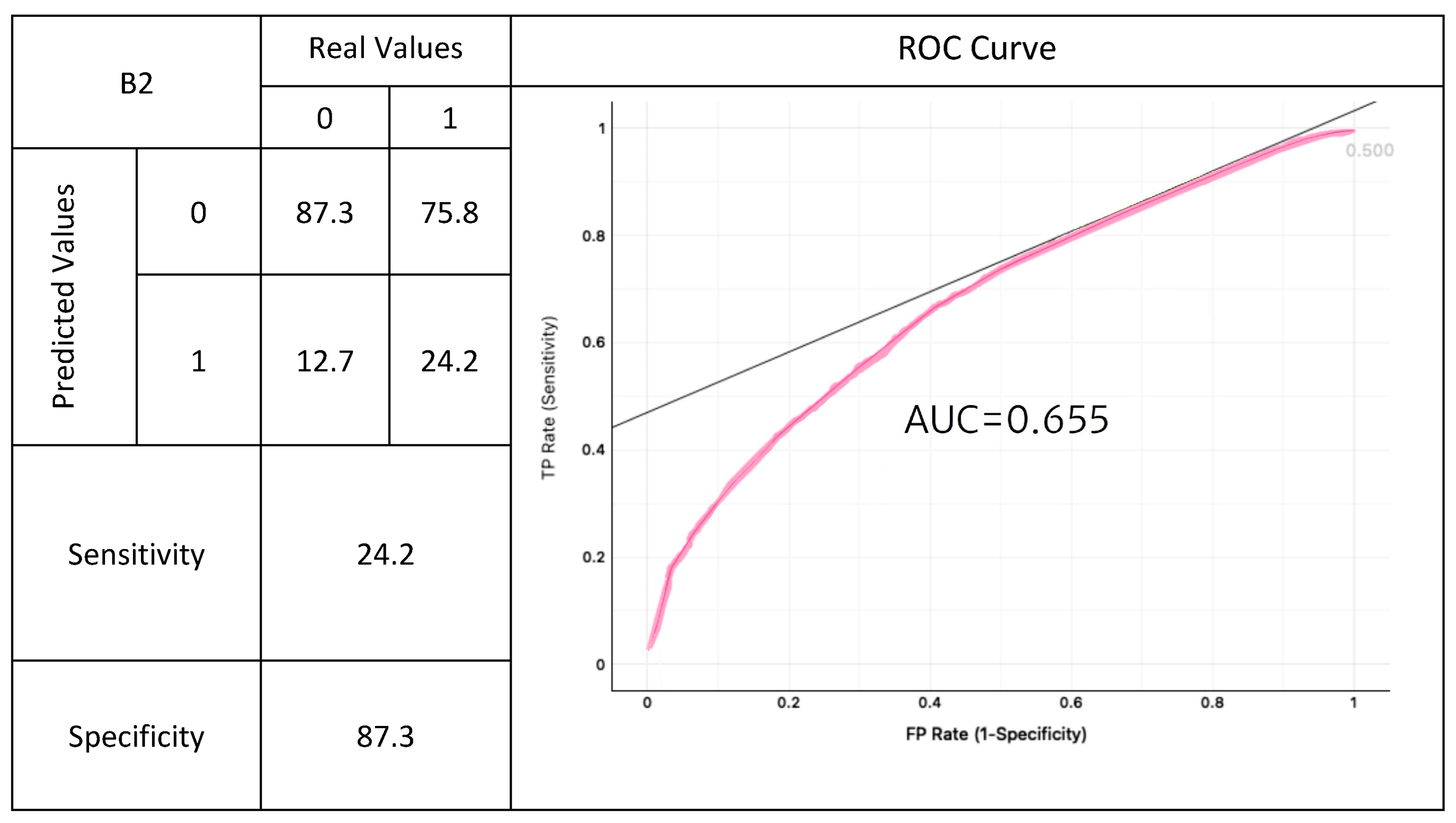
The regression analysis was applied to two different sets of variables, forming models B1 and B2. The results obtained for the two logistic regression models are summarized in the following tables, which include the results of the confusion matrix, the ROC
5 curve, the estimation of the AUC (Area Under the Curve), and the corresponding sensitivity and specificity values (
Figure 3).
As can be observed, the confusion matrix for the logistic regression shows a high percentage of false negatives, meaning the model predicts the absence of jellyfish in a significant number of beaches that, in reality, are prone to jellyfish landings. The model exhibits low sensitivity, and the Youden index value (0.09) indicates a medium to low capacity for the model to accurately discriminate and predict beaches with or without jellyfish presence. Despite this, the model’s predictive ability is moderate, with an AUC value of 0.652.
The procedure was repeated, focusing only on variables with high statistical significance in the binomial logistic regression (
p < 0.001), resulting in a simplified model with more refined parameters (
Figure 4).
To facilitate a clearer understanding of the results presented in
Figure 3 and
Figure 4, additional clarification is provided regarding the variables in the confusion matrix and ROC curve.
Real Values: These represent the actual presence (1) or absence (0) of jellyfish on the beaches.
Predicted Values: These indicate the model’s prediction of jellyfish presence (1) or absence (0).
Sensitivity: This refers to the proportion of true positives correctly identified by the model (i.e., beaches with jellyfish correctly predicted).
Specificity: This measures the proportion of true negatives correctly identified (i.e., beaches without jellyfish correctly predicted).
AUC (Area Under the Curve): A measure of the model’s overall predictive ability, with values closer to 1 indicating better discrimination between the classes.
In
Figure 3, Model B1 (with all variables) shows a sensitivity of 19% and specificity of 90.7%. In
Figure 4, Model B2 (with statistically significant variables) slightly improves sensitivity to 24.2%, while specificity decreases to 87.3%. These results highlight that while the model performs well in predicting beaches without jellyfish (high specificity), its ability to accurately predict beaches with jellyfish (low sensitivity) remains limited.
Sensitivity and specificity are calculated from the confusion matrix. Sensitivity (also known as the true positive rate) is obtained by dividing the number of true positives (cases where the model correctly predicted jellyfish presence) by the total number of actual positives (the sum of true positives and false negatives).
Specificity (or true negative rate) is calculated by dividing the number of true negatives (cases where the model correctly predicted jellyfish absence) by the total number of actual negatives (the sum of true negatives and false positives). These two values indicate how well the model identifies both beaches with jellyfish and those without.
Logistic regression achieves good specificity values (prediction of true negatives) but low sensitivity, which relates to the model’s ability to correctly identify true positives concerning the total number of actual positives. In this context, ’real values’ refer to the actual presence or absence of jellyfish on the beaches, while ’predicted values’ are the model’s forecasts of jellyfish presence or absence. In other words, there are many days with jellyfish that the model predicts as their absence. The AUC value is slightly better in this case (0.655).
The results for both models are also equivalent regarding sensitivity and specificity, with a slight improvement in the correct positive ratio of the model compared to Model B2 (sensitivity = 0.24, compared to 0.19), suggesting that the reduction in the number of variables does not significantly enhance the model’s predictive capacity. In both models, the ability to classify and predict the susceptibility of beaches to jellyfish landings is accurate when identifying beaches with a lower probability of receiving them. However, when it comes to identifying beaches with high susceptibility, the model fails and tends to underestimate, predicting a lack of jellyfish on beaches and days when they do indeed occur, thereby underestimating the number of beaches likely to receive jellyfish along the coast.
Regarding the importance of each variable in jellyfish presence, the coefficients ß in the two regression models indicate the same trend. The influence of some variables is slightly greater than others, though the significance levels are not very high in any case. In this respect, some variables have demonstrated better significance in the applied logistic regression, above 0.001. A significance of p < 0.001 in the binomial logistic regression indicates statistical evidence that at least one of the independent variables is significantly related to the dependent variable in the logistic regression model.
The results show, albeit with low confidence levels, the predominant importance of circumstantial variables such as wind data, direction, and speed. The model indicates that on days with little wind, the arrival of jellyfish at the beach is more frequent. However, it should be noted that these data may be conditioned by the fact that on windier days, the likelihood of sightings is hindered by wave activity, and beach attendance is lower—both factors that may underlie the association indicated in the model.
Regarding structural variables, coastal drift appears to be particularly influential, with its direction from east to west being associated with increased risk. Salinity also shows significant effects, with an inverse relationship, indicating that areas with lower salinity are more prone to jellyfish landings. Other variables related to the physiographic characteristics of the beach, such as depth, are directly associated with jellyfish presence. Beaches with a small opening angle and/or protection around their perimeter, a high average slope, a small opening angle, or a short length of contact with open sea seem to correlate with an increase in landing frequency.
3.2. Relationships Between Potential Causal Variables and Hazard-Analysis of Bivariate Spatial Coincidences and Application of Basic Statistics
The results obtained through the application of binomial logistic regression have highlighted the challenges posed by the selected predictor variables for analysis using tools based on multivariate statistical correlation.
In light of the lack of conclusive results, this phase of the analysis has opted to identify associations and potential cause–effect relationships through direct interrelations between pairs of variables (conditioning factors and hazard) to simplify the analysis for greater clarity and effectiveness.
Regarding the relationship between salinity and jellyfish frequency, it was observed that beaches with higher salinity tend to exhibit lower hazard levels. However, this correlation is not consistent across all areas, particularly in regions close to the capital and on the beaches of Nerja.
Currents also demonstrate significant influence: surface Atlantic currents are associated with increased hazard levels on western beaches, while Mediterranean currents, especially in the eastern extremity, typically coincide with lower hazard levels, with some exceptions. East–west coastal drift predominantly and clearly expands across the beaches with higher hazard levels. Approximately 90% of the beaches with the highest levels of hazard are affected by eastward coastal drift currents, which means they receive water and materials transported from Mediterranean origins.
Regarding underwater vegetation, although its presence generally coincides with lower hazard levels, the sample size is so limited that no representative conclusions can be drawn. Concerning average depth, it was found that greater depth correlates with higher hazard, with 65% of the deeper beaches exhibiting very high levels of danger.
The analysis of average slope indicated that beaches with gentler slopes tend to be less hazardous, although no clear pattern is observed across all areas.
A high correlation was found between the presence of artificial protection and elevated hazard levels; 90% of the most hazardous beaches have some form of protection, with double protection predominating. The term “lateral protection” refers to coastal protection structures (such as groynes, artificial beaches, or ports) and natural formations (such as capes or rocky coasts) that act along the perimeter of the beach. These elements interrupt coastal drift currents, promote the sedimentation of transported materials, and contribute to beach protection, thereby increasing the hazard levels related to jellyfish presence.
Coastal physiography also plays a role in hazard: beaches with coastal flats exhibit lower hazard, while rocky coasts, such as those in Maro, tend to be more dangerous. Regarding the orientation of the beaches, those facing southwest and south showed lower hazard levels. By contrast, beaches oriented towards the east and southeast recorded high levels of danger. The opening angle did not allow for the establishment of a clear relationship due to the high variability among beaches. However, it was found that a shorter length of contact with open sea is related to higher hazard levels.
Proximity to watercourses is generally associated with lower hazard, although there are beaches that do not follow this trend, introducing some inconsistency in the correlation, which may be justified by differences in freshwater inputs.
Lastly, the lithological composition of the seabed and artificial intervention on the beaches showed limited influence on hazard levels. Although beaches with artificial interventions are often more hazardous, the scarcity of non-intervened beaches in the study complicates a precise assessment. Similarly, the presence of reefs is so common along the coast that its specific influence on hazard could not be determined.
Table 2 below presents the observed relationships between potential causal variables and hazard levels across the analyzed beaches.
3.3. General Explanation of Jellyfish Distribution
As illustrated in the explanatory cartographic scheme shown in
Figure 5, the distribution of jellyfish arrivals along the Malaga coast is primarily explained by two variables: the orientation of the coastline and beach and the direction and nature of coastal drift at each point. To the general rules imposed by these conditioning factors, the incidence, albeit to a lesser extent, of other variables that help explain exceptions to the general behavior of spatial distribution is logically added. Among these variables are the existence of lateral protections on the beach, the position of the Atlantic or Mediterranean current, depth, or the contribution of freshwater from river courses.
With all these records and observations, the integrated analysis of the spatial distribution of beach hazards and the potential explanatory factors allows us to conclude that, in general terms, the beaches most prone to receiving jellyfish are characterized by the following attributes:
Orientation: The beaches oriented to the east and/or south receive the preferential influence of the medium and deep Mediterranean current, which carries jellyfish swarms from the Alboran Sea.
Coastal Currents: They are traversed by east–west coastal drift currents or are located at bifurcation points of the drift currents (coves), leading to a tendency for transport slowdown and retention.
Perimeter Protection: They possess a perimeter articulated by elements that act as protective barriers, interrupting coastal drift and promoting the sedimentation and retention of transported elements. These protective elements can be artificial (groynes, artificial beaches, ports, etc.) or natural rocky formations that contribute to enclosing the beach.
Morphology: They exhibit a closed morphology, with average and/or reduced lengths of contact with the open sea.
3.4. Comparison of Predicted vs. Actual Hazard
The comparative analysis of the actual hazards at each beach in relation to the estimated proclivity to receive jellyfish, based on the criteria deduced in this research, shows that, according to our predictions (which are based on the hazard distribution model developed in this study, taking into account factors such as beach orientation and coastal currents), 65% of the beaches exhibit characteristics suggesting a predisposition to elevated hazard levels based on the identified criteria. Within this group, 60% fall into higher categories (very high and high) of empirically observed hazards. Overall, these data suggest that the generation of hazards related to jellyfish presence on beaches largely responds to the identified proclivity factors.
On the other hand, when analyzing the cases of non-coincidence between the predicted proclivity to receive jellyfish according to our criteria and the actual hazard of the beach, it is observed that there are beaches that, while exhibiting some characteristics of identified hazard proclivity, also possess other traits that act, as identified, as mitigating factors. This is the case for the presence of freshwater in the vicinity of the beach. Examples of this scenario include the beaches located in the stretch from La Galera in Estepona to Casablanca in Marbella and the Guadalhorce beach in Málaga. Additionally, other factors acting as deterrents on some of these beaches include the direction of coastal drift. Despite being oriented towards the east, they are traversed by drift flowing from west to east, which invalidates or reduces the effectiveness of the eastern orientation of the beach as a proclivity factor, given that the preferred origin of jellyfish banks is to the east. Examples of this circumstance include the stretch from Las Doradas to Luna in Mijas, Almayate to Valle Niza in Vélez Málaga, and Lagos to El Chucho between Torrox and Nerja.
Beaches with a tendency to present low hazard values are characterized by the following particularities:
Orientation: Their orientation to the west–southwest places them in the lee of the medium and deep Mediterranean current, which carries jellyfish swarms from the Alboran Sea.
Coastal Drift Currents: They are traversed by drift currents circulating from west to east. In some cases, although they receive drift currents from the east, they are situated in shadow areas behind the cessation of easterly drift due to artificial elements located to the east of the beach.
Morphology: They exhibit an open morphology, with extensive lengths of contact with open sea.
Freshwater Sources: They are located in coastal stretches that can receive freshwater input from rivers during the summer period.
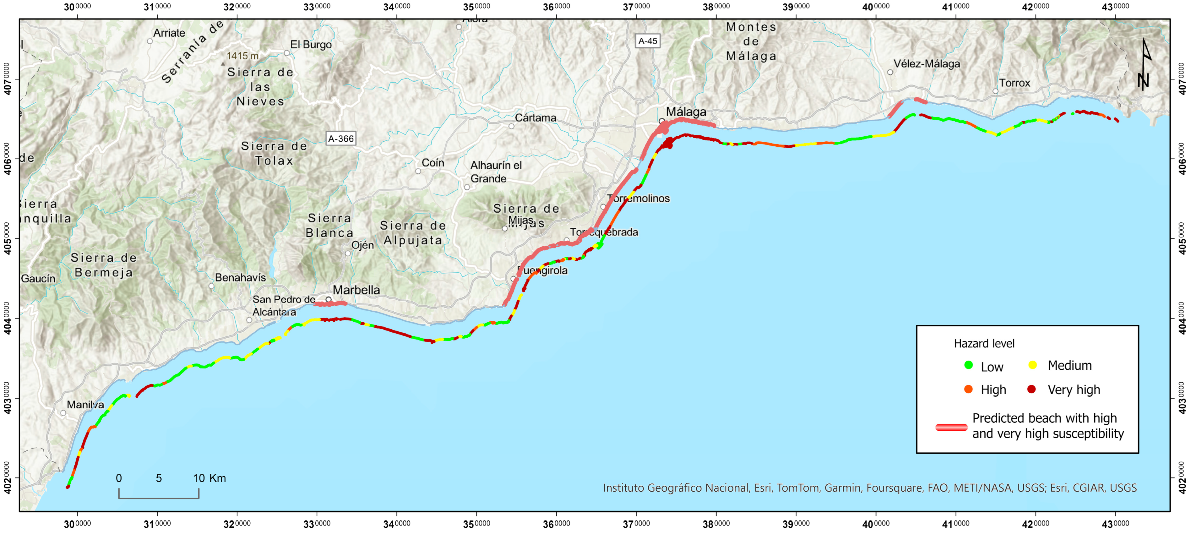
The map represented in
Figure 6 shows the combined prediction of the beaches that, according to the criteria deduced in our research, demonstrate a higher proclivity to receive jellyfish and, at the same time, do not present any opposing deterrent factors to their arrival. When comparing the results of this prediction with the actual empirical data of high and very high hazard, it is observed that 76% of the beaches predicted to have high and very high susceptibility according to our criteria indeed exhibit high and very high hazard levels.
These data generally validate the operational logic of both the identified factors of proclivity to receive jellyfish and the factors that hinder access and deter arrival. The spatial pattern and general coherence between the model of spatial distribution of jellyfish swarms and the explanatory factors associated with the morphology and functioning of the coastline allow us to observe, despite their limitations, the considerable potential as a source for the inventory that has been compiled, as well as the validity of the hazard indicators. Overall, the results show the coherence of the explanatory model of hazard distribution proposed in this research for Costa del Sol.
4. Discussion
The analysis of the characteristics shared by beaches with higher or lower propensities to receive jellyfish advances the concept of conditioning factors for danger. Firstly, statistical tools such as binomial logistic regression have been applied, which, despite limitations in the results, have allowed for the identification of certain underlying factors in specific beaches that may influence their greater or lesser propensity to receive jellyfish.
As shown in the results chapter, the two regression models applied (Model B.1, using all variables, and Model B.2, with the selection of those with better statistical significance) yield very similar results. The resulting AUC value, an indicator of the model’s predictive quality, does not present strong predictive capability (AUC = 0.652 for Model B1 and AUC = 0.655), which is inferior to models obtained through logistic regressions applied by other authors on similar issues (presence or absence of mass movements on slopes), such as Ayalew and Yamagishi [
34] and Yilmaz [
38]; these authors obtained AUC values around 0.8, endowing their models with high explanatory and predictive capacity.
Since the probabilistic model (logistic regression) did not yield the expected results, an alternative approach was adopted in this section, focusing on a qualitative and cartographic analysis of the causal factors. The limitations of the results obtained through logistic regression can be attributed to various factors, such as poor data fit between the dependent and independent variables due to the scale of the data and the differing statistical variability among the resultant and predictive variables. The diverse nature of the factors influencing jellyfish occurrences, as well as their variable statistical expressions, provide broad variance in the dataset to be related, which mixes variables with very dispersed data with others distributed in very narrow ranges, resulting in similarly disparate distribution functions. Although logistic regression is the best tool for analyzing such heterogeneous data, the case study involves variables that exhibit very limited variability (repetition of two or three numerical values or nominal attributes across all beaches).
The limited variability is sometimes related to the inherent nature of the variable (for example, vegetation, orientation, or lithological composition of the seabed), or, in other cases, relates to the poorly detailed scale of the data source, generating the effect of a spatial constant. An example of this is salinity; while various authors [
11,
18,
41] confirm that it relates to jellyfish proliferation, the lack of precise and varied data per beach hinders the statistical demonstration of causality. Other variables, such as the presence of artificial intervention operations on the coastline or artificial reefs, are characterized by their abundant and homogeneous distribution across most selected beaches for analysis and their dispersed distribution along the entire coast, making it a constant that is difficult to correlate with the resultant variable.
Another issue underlying deterministic models based on the correlation between causal factors and effects (in this case, jellyfish detection on the beach) relates to the potential temporal lag between the origin and the confirmation of the consequence. For instance, the arrival of jellyfish on the beach can occur on days with significant east winds, without necessarily coinciding with the wind activity and jellyfish arrival. This fact could explain the disparity between the theses maintained by various authors and our results regarding the role of wind in the arrival of jellyfish on the beach. Castro-Gutiérrez et al. [
14], using models based on fuzzy logic, demonstrate that winds perpendicular to the coast lead to a greater presence of jellyfish swarms in the central and eastern areas of Málaga, while parallel winds have a greater influence on the western coasts. Similarly, other authors assert that the main factors influencing jellyfish stranding on beaches are the direction and speed of the prevailing local winds [
13,
18,
49,
50]. In our case, however, as indicated by the logistic regression data (B coefficient), the role of wind speed regarding jellyfish arrival is not direct but inverse; that is, days with higher wind speeds coincide with lower jellyfish sightings. As noted, the possibility of wave action and reduced visitation may be behind the low records in Infomedusa.
Use of Cartographic Analysis and Combined Strategies for Identifying Causative Factors of Danger
Given the limitations of using multivariate statistics for predicting the underlying causes of a beach’s susceptibility to receiving jellyfish, the analysis of the interrelationship between causal factors and jellyfish arrival has focused on cartographic analysis and supported by comparative graphs of each variable’s trend with danger levels. The interpretation of causal processes improves when observed from an overall perspective, considering the relative position of each causative variable and the receiving beach along each coastal stretch. In this phase of analysis, the ultimate goal has been to observe general trends in coastal processes that may relate to jellyfish arrival and to identify the beach model that, according to its characteristics, is more susceptible to receiving jellyfish and, therefore, potentially more dangerous.
As previously mentioned, the distribution of jellyfish arrivals on the Málaga coastline is primarily explained by the orientation of the coast and littoral drift, although other variables such as lateral protections, currents, depth, and river contributions also influence the observed exceptions.
Regarding the orientation of the coast as an explanatory factor, 95% of the beaches classified with very high danger are oriented toward the east and south, while beaches facing west, southwest, and south–southwest are positioned at lower danger levels. None of the beaches characterized by these orientations exhibit very high danger values. This is explained by their position downwind of the flows from the east, from where more general studies assert that the swarms originate, moving toward the shore from the Alboran Sea [
18]. The coastal stretch extending from the Fuengirola area to the city of Málaga exemplifies a coastal area exposed to the windward side, receiving perpendicular Mediterranean currents, which is associated with a clear predominant trend for the beaches to present high and very high danger levels.
When the analysis is conducted at a detailed level, the orientation of the beach entrance toward the predominant source area of swarms may determine susceptibility to a greater extent than the beach’s actual location, contrary to the assertions of Rubio and Gutiérrez [
23], who identify the eastern coast as a higher susceptibility zone due to its proximity to the originating diffusion area. The beach of El Cristo, near Marbella, serves as a good example of this observation. Although situated in a high danger coastal stretch, its general orientation favors receiving east winds but is noted for its moderate danger in its surroundings. This beach has a southwest orientation and is also sheltered from east winds by a lateral protection bar at its eastern end. In the study by De la Fuente et al. [
21], focusing on the western stretch of Costa del Sol, it is evident that this beach has a lower than average danger level and stands out in the Marbella stretch for having fewer jellyfish than those in its vicinity.
The hypothesis explaining the observed danger distribution as a result of the coastal stretch’s orientation and its exposure to east winds is also confirmed when analyzing the eastern sector of Costa del Sol. Downwind positions, such as those of most beaches between Mezquitilla and Ferrara, present low jellyfish arrival values.
Littoral drift is also a fundamental explanatory factor in the distribution of jellyfish across beaches, with the east–west flow responsible for high danger in most coastal sectors it affects.
Among all the beaches on Costa del Sol, 17.58% classified as high and very high danger are closed. Of the closed beaches, totaling 18, 89% fall within the high and very high danger intervals, representing 16.6% and 72.2%, respectively. Only two closed beaches fall within the medium danger interval, representing 11.1%, while none are classified within the low danger interval.
Another variable positively related to the increase in reception frequency is the presence of protective elements and/or the generation of sand deposits around the beach perimeter. This morphology promotes sediment accumulation and deposition processes, as well as the retention of jellyfish in its waters, which may be recorded as data for consecutive days. The percentage of highly dangerous beaches that have some form of protection is 90%, and 55% have double protection (east and west).
Beach protection is also associated with the length of the coast exposed to the open sea. When this distance is shorter, the beach tends to be more sheltered, reproducing the previously described accumulation effect, resulting in elevated danger values shown in the data analysis.
Considering other reasons why some beaches with low danger are located in particularly prone coastal stretches, one can cite the possible impact of freshwater contributions to beaches near the mouths of significant rivers. Reports suggest that the influx of freshwater causes the saline barrier that normally separates coastal water from the open sea to move further offshore [
51,
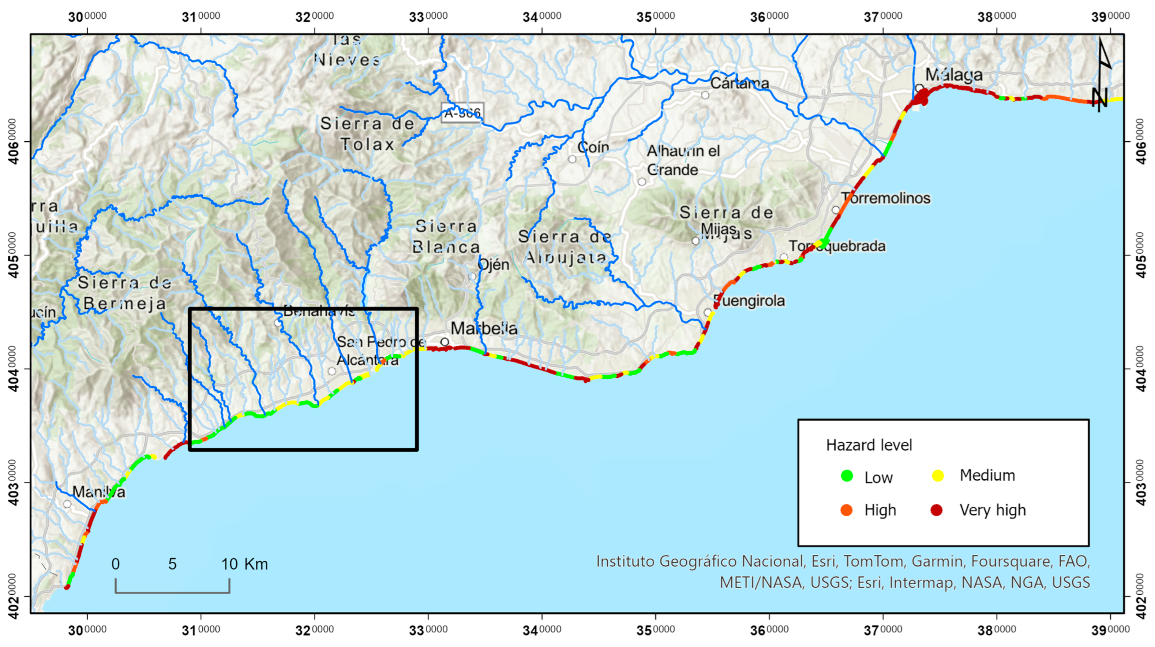
52]. This phenomenon limits jellyfish’s ability to approach the shore, as greater freshwater flow results in a larger distance between the saline barrier and the coast. This is evident in the case of Guadalhorce beach in the Bay of Málaga, which represents an exception of low danger in a stretch of high danger coast. The shallow depth of the beach and proximity to a significant watercourse, such as the Guadalhorce River, may explain this observation. However, the statistical analysis of the relationship between decreased danger due to the proximity of the beach to a watercourse has not provided data to substantiate this argument. Nevertheless, cartographic observations of various cases appear to indicate that freshwater contributions do not simply correspond with the presence of a nearby watercourse, but rather it is essential to consider whether these are watercourses with real contributions of water during the observation period (summer). Furthermore, the freshwater input in an area does not occur concretely along the coastal shoreline (contribution from a watercourse at a specific beach) but may have a cumulative effect, whereby an area with a high density of small watercourses can generate a considerable freshwater influx. This phenomenon may be acting as a dissuasive factor of danger in the stretch of low values observed between Estepona and the Nueva Andalucía area in Marbella.
Figure 7 shows the number of watercourses that irrigate the coast in this stretch, which are relatively abundant.
The role of freshwater concerning the proliferation of jellyfish, however, presents nuances in the opinions of different authors. Bellido et al. [
18] indicate that the influx of freshwater reduces salinity and surface density in the Alboran Sea, alters the depth of water mixing, and decreases the entry of colder water through coastal upwelling, which in turn raises the sea surface temperature, a factor associated with jellyfish proliferation. Similarly, MITECO [
52] suggests that climatic factors contributing to increased coastal temperatures may be an indirect cause of the rise in jellyfish numbers. Additionally, Avian et al. [
53] propose that elevated water temperatures favor the development of
Pelagia noctiluca eggs, induced by metabolic changes. In any case, as can be observed, our analysis focuses on the role of freshwater at the beach itself, rather than in open waters, where it may generate changes in temperature and salinity dynamics that influence current direction and upwelling phenomena.
Although this study primarily relies on quantitative methods such as logistic regression and cartographic analysis, previous research by Cantarero et al. [
22] has already incorporated surveys from beach users to evaluate the vulnerability to jellyfish stings. These surveys provide valuable qualitative data that can complement quantitative models and offer insights into local perceptions regarding the presence and impact of jellyfish. While this study did not include such surveys, it is suggested that future work could integrate both the quantitative and qualitative data to create a more comprehensive understanding of the factors influencing jellyfish occurrences. Incorporating the opinions of residents and beach users could further enhance the validity and applicability of future research.
To further complement the discussion on jellyfish management, the methodology proposed by De la Fuente et al. [
54] in the same study area offers additional insights into effective mitigation measures. In their approach, a methodology is outlined for managing jellyfish presence, based on a sample of 32 beaches along Costa del Sol, Málaga. The process is divided into three phases: first, a user and beach diagnostic is conducted, which leads to a cartography of priority areas for action; second, mitigation and vulnerability-reducing measures are proposed; and third, the factors that trigger these interventions are examined, with a matrix of proposals assigned based on beach typology. The results indicate that 13 beaches are suitable for activating some of the proposed interventions, with measures for dangerous events being feasible on nearly all priority beaches, although vulnerability measures are more restricted due to the necessary conditions for their installation, such as accessibility and surface area.
5. Conclusions
This study has provided a detailed view of the factors influencing the arrival of jellyfish to beaches in the Mediterranean area, highlighting the utility of cartographic analysis and logistic regression in identifying causal variables. However, the resulting explanatory models have demonstrated only moderate predictive capacity, emphasizing the complexity of the factors involved. The identification of various causes, such as disparity in statistical distribution and the lack of spatial or temporal concurrency between causal factors and sightings, underscores the need for more robust analytical approaches to improve model accuracy.
Similar studies have been conducted in other Mediterranean countries, where hazard mapping and the analysis of environmental variables have been used to predict jellyfish presence and improve coastal management strategies [
18,
40]. These studies contribute to a broader understanding of the dynamics of jellyfish blooms and their impact on coastal ecosystems, offering valuable insights for the management of this phenomenon in the Mediterranean region.
The hazard mapping obtained (frequency of jellyfish arrivals per beach) has constituted the foundation (dependent variable) for generating an exploratory deterministic model of the potential causal variables affecting a beach’s susceptibility to jellyfish reception. The first of the methods applied for identifying explanatory factors was binary logistic regression, utilizing a total of 21 independent or predictive variables. The resulting data from the application of this model, in both its initial and refined versions, have proven to be only moderately explanatory (AUC = 0.6).
Several causes have been identified that may explain the moderate capacity of the model to establish correlations with the dependent variable (disparity in statistical distribution, lack of spatial and/or temporal concurrency between the position of the causal factor and the consequence at the beach (sighting records in Infomedusa)). Cause–effect relationships are defined in many cases through spatial transfer. For this reason, the overlay relationships used to perform regression and relate potential causal variables with beach hazards are not always feasible. Various strategies are proposed in the discussion to enhance the analytical capacity of this powerful tool (logistic regression).
Another strategy employed to identify factors explaining the varying degrees of susceptibility and their role in hazard production has been the comparative and integrated analysis of maps of the various potentially causal variables and the hazard cartography. The visual comparison of the distribution of processes and the sequencing of their behavioral dynamics has allowed for the suggestion of an explanatory model for the generation of hazard in the study area. Unlike what occurs in correlation-based statistical analysis, this deductive procedure allows for the consideration of not only cause–effect relationships based on overlap and spatial concurrency but also other spatial relationships responding to more complex topological dynamics (adjacency, chain connection, connection through a third variable, etc.), which effectively contribute to explaining the underlying relationships leading to the preferential arrival of jellyfish at specific beaches.
As a result of this analysis, a "typical beach" model has been proposed and described, integrating the characteristics that make it more prone to receiving jellyfish. This model is synthesized in a diagram highlighting the main characteristics of beaches with high hazard values, which include a geographical orientation toward the east or south, exposing them to the influence of the mid and deep Mediterranean current. Furthermore, these beaches are traversed by coastal drift currents flowing from east to west and are located at points where these currents tend to slow down transport, facilitating the retention of elements. Another important factor is the presence of protective barriers, which can be either artificial or natural, that interrupt coastal drift and favor sedimentation. The coastal morphology of these beaches tends to be enclosed, with a length of contact with the open sea ranging from medium to reduced.
Conversely, beaches with low hazard values exhibit opposite characteristics, such as a geographical orientation toward the west–southwest, positioning them downwind of the Mediterranean current. These beaches are traversed by coastal drift currents flowing from west to east and, in some cases, are found in shadow areas due to the obstruction of drift by artificial elements situated to the east of the beach. The morphology of these beaches tends to be open, with extensive lengths of contact with the open sea, and may receive freshwater contributions from rivers during the summer period, which also helps reduce their hazard.
Thus, this study provides a valuable tool for predicting and mitigating the presence of jellyfish, contributing to more effective coastal management and the protection of marine ecosystems and beach users.


