Article

Monsoon-Driven Dispersal of River-Sourced Floating Marine Debris in Tropical Semi-Enclosed Waters: A Case Study in the Gulf of Thailand

by
Kittipong Phattananuruch
1 and
Tanuspong Pokavanich
2,*
1
Faculty of Fisheries, Kasetsart University, Bangkok 10900, Thailand
2
Department of Marine Science, Faculty of Fisheries, Kasetsart University, Bangkok 10900, Thailand
*
Author to whom correspondence should be addressed.
J. Mar. Sci. Eng. 2024, 12(12), 2258; https://doi.org/10.3390/jmse12122258
Submission received: 31 October 2024 / Revised: 28 November 2024 / Accepted: 5 December 2024 / Published: 9 December 2024
(This article belongs to the Section Marine Pollution)

Abstract

:
Marine debris (MD) causes significant threats to marine ecosystems. However, limited research addresses its transport of MD in tropical shallow semi-enclosed seas. This study applied a validated 3D hydrodynamic model and a particle tracking model to simulate the seasonal distribution of floating marine debris (FMD) originating from major river mouths in the vicinity of the Gulf of Thailand (GoT). The aim was to examine seasonal distribution patterns and variations influenced by sea surface circulation. Simulated particles were released every six hours from 12 river mouths and tracked over three years. Results revealed that seasonal currents drive the distribution of debris between the eastern and western regions, as well as its export and import across the gulf. The upper Gulf of Thailand (UGoT) exhibited the highest concentration of debris, with around 50% of the total released particles ending up onshore across the GoT, varying seasonally. An analysis showed that 74% of the debris released within the gulf remains there. Additionally, the GoT receives approximately 10% of the debris from rivers located outside its boundaries. Findings from this study suggest that the GoT, as an example of a tropical semi-enclosed sea, functions as both a sink and a source for FMD. These results could support the development of strategic seasonal cleanup frameworks, optimizing efforts during peak debris accumulation periods to enhance management efficiency. In addition, the mapping of debris distribution provides critical data for assessing and mitigating marine environmental impacts in the GoT.

1. Introduction

Solid human-generated waste released into marine environments, intentionally or accidentally, is termed marine debris (MD) [1]. Anthropogenic debris, particularly plastics, is prevalent in marine ecosystems, with plastics being the dominant component of floating marine debris (FMD) globally [2,3,4]. Since the 1950s, the increase in plastic production and disposal has raised significant environmental concerns. It is estimated that by 2050, approximately 12,000 metric tons of plastic waste will accumulate in the environment, posing risks to marine ecosystems, the economy, and human well-being [5,6,7].
Rivers are a major pathway for transporting large quantities of land-based MD to the sea [8,9,10], as supported by observational studies in various regions [11,12,13]. In the ocean, this debris is distributed by physical processes such as currents, waves, and winds [14,15]. Plastic debris undergoes weathering, fragmenting into microplastics through physical degradation. These tiny particles can accumulate contaminants and enter living organisms, subsequently moving up the food chain [16,17].
To effectively manage and mitigate MD issues, understanding its dispersal characteristics is essential. Previous studies have investigated MD dispersal using both field observations and numerical modeling. Field observations include shoreline debris collection, nets, sediment sampling, and remote sensing. However, these methods have limitations such as the sensitivity to weather conditions, budget constraints, and monitoring frequency [18,19]. The durability of plastic and its lower density compared to seawater enable it to float and be transported over long distances by currents, winds, and other environmental forces [15,20]. As a result, identifying its source or exact point of release becomes difficult [19].
Supplementing field monitoring efforts, numerical models have been widely employed to study the transport and distribution of MD on both local and global scales, [14,21]. Lebreton et al. [22] demonstrated a connection between the accumulation zones of floating debris and their sources in the global ocean, based on simulation results. The plastic debris transport model offers more detailed insights into the origin of the debris, helping to verify and support the identification of sources and sinks of MD collected through field observations [21,23,24].
The Gulf of Thailand (GoT), located in Southeast Asia, is a semi-enclosed sea with a single connection to the South China Sea (SCS) in its southeastern region (Figure 1a). The average bathymetry in the GoT is 40 m, classifying it as shallow water (Figure 1b). Water circulation in the GoT is primarily driven by monsoonal winds and water exchanges with the SCS. During the southwest monsoon (May–August), clockwise circulation prevails, leading to water outflow from the eastern region of the gulf. Conversely, during the northeast monsoon (November–January), counterclockwise circulation prevails, with water exiting from the southern region of the gulf [25,26]. Considering the significant amount of FMD input to the GoT, it has been contaminated with plastic debris, predominantly released from major rivers. It is estimated that over 30,000 pieces of plastic debris are released from rivers in the upper Gulf of Thailand (UGoT) per hour [27].
The GoT, as an example of tropical waters affected by major MD-contributing countries, has been identified as a hotspot for FMD. Previous studies investigating floating objects and MD dispersal in the GoT have utilized field observation and numerical models [28,29,30,31]. These studies highlighted the different seasonal aggregation and dispersion patterns of FMD. However, these studies, which considered specific timeframes and limited release points, may not sufficiently capture the seasonal variations in MD distribution from river mouths to accumulation zones. Moreover, the exchange of MD between the GoT and adjacent areas has not been adequately addressed in previous studies, leaving a critical gap in understanding the transboundary movement of MD. Unfortunately, the number of scientific studies on MD dispersal models in this region is significantly less when compared to other parts of the world, highlighting a gap in addressing the problem.
In this study, we selected and applied the Delft3D model, combined with a particle tracking model, to simulate the distribution of FMD originating from major river mouths. The Delft3D model (version 4.04.01) is a computer software that has been broadly applied to study hydrodynamic features in coastal, river, and estuarine areas, e.g., the Yangtze estuary [32], Portuguese coast [33], and eastern GoT [34]. Additionally, it has been applied to simulate the trajectories of MD in the sea or from river mouths, providing for the identification of its sources and fate [35,36].
Using the GoT as a case study, we report the key distribution characteristics of FMD in a tropical shallow semi-enclosed sea within the Asian–Australian monsoon zone, as well as its exchange with adjacent areas. Our study identifies the abundance of FMD along the coastline, illustrates the accumulation zones, analyzes the FMD travel time and its associated effects, and traces its sources in the GoT, areas that have not been comprehensively studied in previous studies. These findings provide valuable insights for policymakers and government agencies to design more effective cleanup initiatives and implement policies aimed at mitigating marine debris issues.

2. Materials and Methods

2.1. Field Measurement Hydrographic Data

Hourly observed water level data from 2016 to 2020, collected from five tidal stations that surround the GoT, included the Laem Sing station, Hua Hin station, Ko Lak station, Ko Mattaphon station, and Ko Prap station. These data were provided by the Hydrographic Department of the Royal Thai Navy. We also retrieved hourly water level data at Vung Tau station, Viet Nam, from 2016 to 2020, provided by the University of Hawaii Sea Level Center, available at https://uhslc.soest.hawaii.edu/ (accessed on 22 January 2024), and monthly mean sea level data from Geting station and Cendering station, Malaysia, from 2016 to 2017, distributed by the Permanent Service for Mean Sea Level (PSMSL), available at https://psmsl.org/ (accessed on 22 January 2024). A total of eight tide stations were used to calibrate the model-predicted water surface elevations (Figure 2).
Three years of measured data of water level, water temperature, water salinity, and flow velocities from the GOT001 real-time station (Figure 2) were obtained from the Hydro-Informatics Institute, Thailand. The data were recorded hourly. In addition, 30 min measurements of water level and water temperature were conducted in 2020 at Munnai Island (Ko Munnai) and Tao Island (Ko Tao). The data collection periods were 366 days for Munnai Island and 303 days for Tao Island, respectively.
We utilized 7-day and 9-day trajectories of two in-house-developed, satellite-tracked drifting buoys, which were deployed in July 2020 at Chonburi and in August 2020 at Chumporn (Figure 2). The drifters collected their latitude and longitude locations and reported them through the Irridium Satellite every 20 min. Each drifter was tethered to a drogue with a 4 m rope, allowing it to provide information about the surface Lagrangian flow velocity. The data trajectory is available at https://hydro-hims.hii.or.th/ocean/buoy.php (accessed on 5 July 2022). For more information regarding the ocean buoy system and its functionality, please refer to the provided resource.
The monthly average sea surface circulation in the GoT, calculated from hourly data from SEAWATCH buoys deployed south of Rayong Province, Ko Chang (Chang Island), Hua Hin, Songkhla Province, and the Platong Oil and Gas Field (Figure 2), as reported by Booncherm et al. [37], was used in the comparison with the simulated circulation pattern.

2.2. Hydrodynamic Model Description

The hydrographic properties of the GoT were simulated using a three-dimensional hydrodynamic model based on the Delft3D-FLOW software version 4.04.01 [38]. The core idea behind the software involves solving unsteady shallow water equations to replicate the non-steady flow and transport patterns driven by tides and meteorological influences within both two-dimensional (2D) and three-dimensional (3D) models. The simplest continuity Equation (1) and momentum Equation (2), as applied in the program, are defined by
· V = u x + v y + w z = 0
d V   d t = g 1 ρ p 2 Ω × V + F + f vis
where ρ is the density of water; x, y, and z are the horizontal and vertical axes; u, v and w are velocity components along the x, y, and z axes; t is time; ∇ is the gradient operator, V is the velocity vector; g is the acceleration of gravity; p is the pressure gradient; Ω is the angular velocity of the earth; F is the friction force; and f vis is the viscous force.
Turbulence or fluctuations in water were simulated in the model based on basic equation called Reynolds stresses, which use the eddy viscosity concept. In Delf3D-Flow, the horizontal eddy viscosity coefficient ( ν H ) is defined by
ν H = ν S G S + ν 3 D + ν H b a c k
where ν S G S is the sub-grid scale horizontal eddy viscosity; ν 3 D represents the three-dimensional turbulence, computed using a 3D-turbulence closure model; and ν H b a c k is the user-defined background horizontal eddy viscosity, representing complex hydrodynamic phenomena.
The vertical eddy viscosity coefficient ( ν V ) is determined by
ν V = ν m o l + m a x ν 3 D , ν V b a c k
where ν m o l is the kinematic viscosity of water; and ν V b a c k is the user-defined background vertical eddy viscosity, which used to account for unresolved mixing.
In this study, we employed a constant background horizontal eddy viscosity and background vertical eddy viscosity at 10 m2/s and 1 × 10⁻⁶ m2/s, respectively. A second order turbulence closure model (k-ε model) was applied to calculate the turbulence energy and the dissipation rate of turbulent kinetic energy using transport equations. Details of the parameters used in this study are provided in Table A1. Additional conceptual descriptions and the model’s equations are detailed in [38].
The hydrodynamic modeling in this study included two models: (1) a validation model used to simulate hydrodynamic processes from 2014 to 2020 (referred to as Model V) and (2) a general circulation model used to simulate the general circulation of the GoT (referred to as Model G). The computational domain of these models covered the GoT region and the southwestern part of the SCS (Figure 3). It consisted of a total of 131,244 grid cells, with a horizontal grid resolution of 2.8 km × 2.8 km and 10 vertical layers defined using a sigma coordinate system. The model was simulated with a time step of 300 s, and results were output every 30 min for model validation.
The initial conditions, including water temperature and salinity for the models, were obtained from the Global Ocean Forecasting System (GOFS) 3.1 at https://www.hycom.org/ (accessed on 7 October 2023) to provide the boundary conditions for the hydrodynamic model. The GOFS is based on the HYCOM (Hybrid Coordinate Ocean Model) + NCODA (Navy Coupled Ocean Data Assimilation) Global Analysis/Reanalysis, offering data at a temporal resolution of every 3 h and a spatial resolution of 1/12° [39].
Water level, salinity, and water temperature were specified at the model’s open boundaries (Figure 3a), combined with meteorological data and river discharge covering the model’s domain, which were used as major model forcing data. Water level data, computed from fifteen harmonic constituents of tides, were extracted from the latest version of TPXO9-atlas (v4) [40], using the Tide Model Driver (TMD) version 2.5 [41]. TPXO encompasses global, regional, and local models of barotropic tides, encompassing bathymetry/depth grids (m), elevations (m), and transport (m2/s). TMD is a MATLAB (version R2024a) toolbox, designed for extracting data from tidal models, developed by the Oregon State University (OSU) and Earth and Space Research (ESR). Additionally, TMD has the capability to predict tidal heights and currents.
Offshore salinity and water temperature data, varying with depth, were retrieved from the GOFS and applied as boundary conditions. Meteorological input data, including wind speed and direction, air pressure, precipitation, air temperature, and total cloud cover, were sourced from the ERA5 global reanalysis dataset at https://cds.climate.copernicus.eu/datasets (accessed on 20 June 2021), provided by the European Centre for Medium-range Weather Forecasts (ECMWF). This dataset is a comprehensive collection that encompasses atmospheric, land surface, and ocean wave data on a global scale. For more details, refer to [42]. In this study, we utilized data at 3 h intervals, covering the geographical domains of the GoT and the SCS.
We obtained river discharge data from the main rivers located in the GoT (Figure 3) by extracting it from the river discharge and related historical data from the Global Flood Awareness System at https://ewds.climate.copernicus.eu/datasets/cems-glofas-historical?tab=download (accessed on 30 April 2021). This dataset offers daily records of global river discharge from 1979 to nearly real-time, achieved by combining sub-surface and surface runoff data from the Hydrology Tiled ECMWF Scheme for Surface Exchanges over Land (HTESSEL) with the LISFLOOD, which is a geographic information system (GIS)-based hydrological rainfall-runoff-routing model [43]. The river names and their abbreviations are provided in Table 1.
For model V, a two-year warm-up period (2014–2015) was applied to eliminate the effects of initial conditions, establishing the model validation period from 2016 to 2020. This warm-up period exceeded the maximum residence time of water in the GoT (571 days [44]), which represents the time required for the complete outflow of water through the system’s boundaries. This time ensured that the initial water temperature and salinity were fully replaced and modified through model processes such as transport and mixing. During the warm-up, the initial surface water elevation and velocities were set to zero. The model results were validated using the hydrographic field measurement data described in Section 2.1.
Model G applied the same setup as Model V but utilized 15-year climatological forcing data averaged from 2006 to 2020. The simulations were conducted by repeatedly executing the model with one year of climatological forcing data over a total simulation period of five years. This included a two-year warm-up period, followed by a three-year simulation to simulate the general circulation. The results in the third year were validated by comparing them with the SEAWATCH buoy data. The resulting surface velocity fields were subsequently used in a particle tracking model. Details of the hydrodynamic model configuration are provided in Table A1.

2.3. FMD Trajectory Modeling

The FMD trajectory model was carried out using a forward particle tracking model, where simulated objects representing FMD were transported by linearly interpolated surface velocities derived from the hydrodynamic model results. As a result, the vertical movement of objects was neglected, and their trajectories did not account for additional dispersion, wave effects, Stokes drift, or the direct influence of surface wind drag.
Simulated objects were released from 12 river mouths (Figure 3) at 6 h intervals (12 objects per interval), starting from the third year of Model G after completing a two-year warm-up period. The object release intervals were determined based on the tidal characteristics of the GoT, which experiences both diurnal and mixed tides, with high and low tide periods ranging from 12 to 25 h, ensuring the comprehensive representation of the daily tidal cycle. The position of each object is calculated at fixed intervals of 300 s, based on the time step of the hydrodynamic model. Although the Mekong River and other main rivers in the Mekong Delta (MKs) include four rivers, we grouped all objects released from these rivers under “MKs” for FMD distribution analysis. The trajectories of the objects were tracked over a 3-year simulation period, resulting in a total of 52,560 objects released.
To establish the initial conditions of the distribution of FMD in the GoT, the released objects were allowed to move freely during the third and fourth years of the simulation. The positions of the objects in the fifth year of the simulation were analyzed, during April, August, October, and December, to represent the seasonal changes corresponding to the first inter-monsoon (first INM), the southwest monsoon (SWM), the second inter-monsoon (second INM), and the northeast monsoon (NEM), respectively. These months were selected based on the Asian–Australian monsoon system, as they reflect distinct variations in wind patterns (both speed and direction) and fresh water fluxes (Figure 4b,c), which influence the seasonal circulation in the GoT. These patterns were examined across 13 defined areas (Figure 4a) in the computational domain. Objects that reached the edge of the computational domain were categorized as outside the domain (OD) objects and were counted separately from those within the 13 specified areas.
The locations of each object were classified into three groups: objects floating on the sea surface (sea surface), objects stranded on the coastline (beached), and objects that moved outside the computational domain. The objects that moved outside the domain were discarded and not returned to the domain. Beached objects remained stationary if the current at their location was zero but could resume transporting when the current velocity increased.
The exchange rate (ER) of FMD between the objects released inside and outside the GoT is crucial for identifying the sources and sinks of transboundary MD and for improving the evaluation of MD retention within the GoT. The ER was calculated as follows
E R i = N i N r i × 100
Here, E R i is the departure rate (entering rate) of the objects as a percentage; i denotes a timestep in days; N i is the number of objects released inside (outside) the GoT that are located outside (inside) at time step i; and N r i is the total number of objects released inside (outside) the gulf at the same time step.
Additionally, the trajectories of the objects released each season during the third year and tracked over a two-year period were analyzed to identify the factors influencing their movement. Travel time is defined as the minimum duration from the release time to the point of departing the computational domain, which then leads to objects being classified as out-of-domain (OD) objects. The percentage of remaining objects within the computational domain was also calculated to represent the proportion of objects that remained in the computational domain.

3. Results and Discussion

3.1. Validation of the Hydrodynamic Model

The model’s performance was validated using the coefficient of determination (R2) method and root mean square error (RMSE) method. We compared the measured water level, water temperature, salinity, and northing and easting velocities with the model results timeframes. Details of the measurement stations, parameters, and validation results are provided in Table A2.
As shown in Figure 5, our hydrodynamic model demonstrates good performance when compared to continuous measurement data across various parameters. The simulated water levels exhibit a high R2 value, ranging from 0.73 to 0.96, while the RMSE for water levels remains consistently low, ranging from 0.07 to 0.30 m across all stations. Similarly, the simulated water temperature and salinity align reliably with the measured data, achieving R2 values of 0.72 and 0.83 for temperature, and 0.48 for the salinity.
Furthermore, our model effectively captures the seasonal variations in both parameters. The simulated northing current velocity at the GOT001 station aligns well with the measurement data; however, its performance is less accurate when compared to the easting velocity. The low accuracy could be attributed to the insufficient resolution of the hydrodynamic grid, which limits the model’s ability to capture small-scale variations and local fluctuations.
Additionally, in comparison to previous studies [25,26,45,46,47], our model outcomes comparable results in terms of the spatial distribution of water temperature, salinity, and circulation patterns, although these results are not presented here. The comparison of monthly surface residual currents in the third year of Model G with measurements from the SEAWATCH data indicates that the model reliably reproduces the seasonal circulation pattern of the GoT (Figure 6) and is suitable for investigating the seasonal distribution of FMD.

3.2. Validation of the FMD Model

While our simulated trajectories closely resemble those of the drifters (Figure 7), it is important to note that they do not match precisely. These disparities may be attributed to the influence of winds and diffusion effects, which are not accounted for in the model but affect the actual movement of floating objects in the sea, as highlighted by the National Oceanic and Atmospheric Administration Marine Debris Program [14]. Further validation of the model using surface satellite drifters will enhance confidence in the predictions of FMD in the future.

3.3. Seasonal Distribution of FMD

During the first INM, the objects accumulated near the river mouths (Figure 8a). Additionally, significant accumulation was observed in the eastern part of the GoT. In the first INM, objects exited the GoT at its southwestern region. In the SWM, objects in the UGoT moved eastward toward the eastern part of the UGoT. Moreover, objects in the GoT move southward toward the mouth of the gulf (Figure 8b). A clear zone with a low number of objects was observed in the upper part of the GoT, between latitudes 10° N and 12° N. The southward movement of objects led to increased accumulation near the TP.
Objects exiting the UGoT contributed to an increased number of objects along the western coast during the second INM, and the presence of exiting objects from the GoT was also observed (Figure 8c). During the NEM, objects were observed only within the GoT without exiting. The objects tended to move westward and exhibited a wider spatial spread compared to previous seasons (Figure 8d).
The distribution of floating objects in each season can be explained by the seasonal patterns of surface circulation (Figure 9). During the first INM, low discharge reduced the water velocity near the river mouths, causing the objects to accumulate in these areas. The slow longshore current and clockwise circulation further contributed to the accumulation of objects in the eastern region (Figure 9a). Strong inflow currents from the SCS prevented objects from exiting the gulf along the eastern coast and brought objects from outside to the southwestern region of the GoT.
Wind-induced currents in the GoT during the SWM (Figure 9b) moved eastward toward the coast, causing more accumulation along the eastern coast. Meanwhile, strong outward currents in the central and southern regions carried objects out of the gulf, creating clear zones and reducing the density of objects in the upper part of the GoT. Two clockwise circulations in the southwestern region of the gulf trapped the objects along their edges, resulting in a high density of objects in these areas.
The strong western longshore current along the western coast of the GoT during the second INM caused objects to exit the UGoT and hindered the expansion of objects released from the TP (Figure 9c). During the NEM, strong inward flow from the SCS causes an increase in the number of objects inside the GoT (Figure 9d). Both westward and counterclockwise circulation contributed to a greater accumulation of objects in the western region of the gulf.
Seasonal distributions of floating objects, influenced by seasonal circulation, have been reported in previous studies, both observational and simulation-based, in other semi-enclosed seas, e.g., Adriatic Sea [48], Black Sea [49], Bohai Sea [24], SCS [50], and UGoT [30,31]. However, the distribution patterns of the floating objects in each area differ due to variations in circulation patterns, which are affected by wind patterns and coastal morphology.
The model’s results during the SWM showed good agreement with the observed distribution of microplastics at the sea surface in the UGoT [30], with a high density of objects located near river mouths and along the eastern coastlines of the UGoT. However, the simulation results for this season exhibited some differences in distribution on the western side. These discrepancies may be attributed to influencing factors that affect the distribution of floating objects and microplastics [15,51,52], such as waves, winds, and physical characteristics of the objects (size, density, etc.) that were not accounted for in this study.

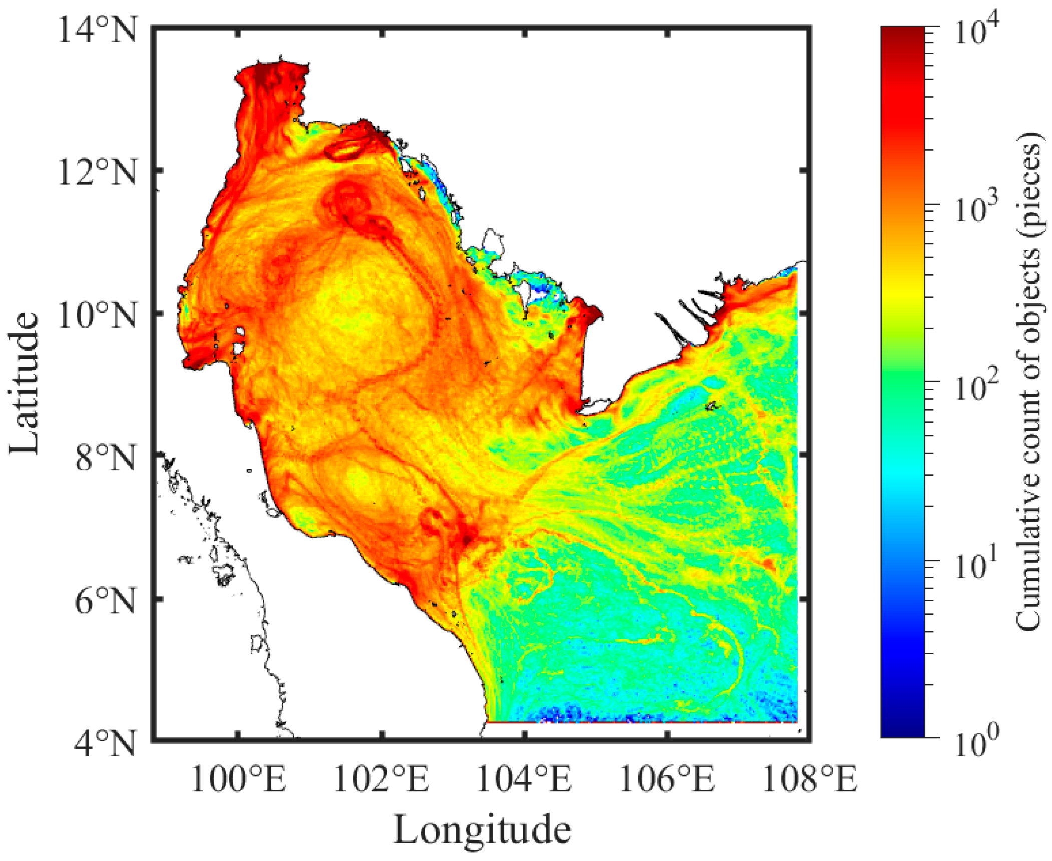
3.4. FMD Hotspots and Accumulation Zones

Hotspots of FMD, highlighted by the cumulative count of objects released from river mouths (Figure 10), are observed in the UGoT, along the western part of the GoT, and in the vicinity of river mouths. In contrast, the center of the clockwise eddy in the middle of the GoT (latitude 10°N) exhibits a low presence of objects compared to its edges. The number of objects in each area across all seasons is presented in Figure 11. Areas with the highest number of objects are referred to as hotspots.
The number of objects within the areas located inside the GoT (areas 1 to 9, excluding area 6) in the first INM (Figure 11a) is higher than in the areas outside (areas 10 to 13), with area 1 identified as a hotspot, highlighted by the highest number of objects across all seasons. Furthermore, the number of objects in area 1 and those OD are nearly equal, but both are greater than the total number of objects in the areas outside the GoT. Areas inside the gulf can be divided into two zones: the eastern zone (areas 2, 4, and 5) and the western zone (areas 3 and 7). In the first INM, the number of objects is not significantly different between the two zones. A decrease in the number of objects observed in the gulf (areas 3, 4, and 7), combined with an increase in objects outside the gulf, confirmed the presence of outward currents during the SWM (Figure 11b). However, the number of objects in area 5 was higher than in the previous season, likely due to the eastward currents transporting objects to Cape Ca Mau.
The distribution of objects during the second INM is largely similar to that observed during the SWM, except for a marked increase in area 3 (Figure 11c). This increase is likely driven by the strong alongshore currents along the western gulf, which transported more objects out of the UGoT. In contrast, during the NEM, the distribution of objects exhibited a different pattern, with the highest number of objects increasing clearly in area 1 (Figure 11d). Westward currents and counterclockwise circulation transported objects from the eastern zone to the western zone, as evidenced by the significant decrease in the number of objects in area 2, while accumulation increased in the western zone.
Seasonal variations in the distribution of FMD between the eastern and western part of the GoT observed in our study are comparable to patterns in microplastic distribution in the UGoT [31] and the northern Indian Ocean [53]. In these regions, seasonal shifts in currents drive the back-and-forth transport of microplastics between eastern and western areas.
The slight decrease in objects in areas 8 and 9 resulted from the inward flow from the SCS, which could carry objects from these areas to area 4. The fewer number of objects in areas 10, 12, and 13 suggested that they moved, either to other areas, or were transported outward from the computational domain by currents during this season.

3.5. Travel Time of FMD

Median travel times of the objects provide additional insights into the distribution of objects and the factors influencing their movement (Figure 12).
The travel time shows unique patterns for each river, even among rivers located within the same area, such as area 1, which includes the Mae Klong River (MK), Tha Chin River (TC), Chao Phraya River (CP), and Bang Pakong River (BP). The shortest travel times were observed during the SWM for the objects released from the Mekong River and other major rivers in the Mekong Delta (MKs), and during the first INM for the objects released from the Kelantan River (KT). Conversely, the longest travel times, approximately 700 days, were observed for the objects released from TC and CP. Compared to the study of [44], our findings for objects released from the MK and PS rivers show good agreement in both pattern and duration. However, discrepancies observed for other rivers may be attributable to the current velocities in deeper layers, where processes such as water intrusion from the SCS and vertical mixing were not accounted for in this study [26].
The number of objects remaining within the domain boundaries, represented by the percentage of remaining objects, provides detailed insights into the distribution of FMD in the GoT (Figure 13). The seasonal variation pattern of the remaining objects released from river mouths reveals clear similarities among rivers located in the UGoT (Figure 13b–e), showing a decreasing trend from the highest percentage of remaining objects during the first INM to the lowest during the NEM. Rivers located in the eastern part of the GoT (Figure 13f,g) exhibited the lowest percentage during the second INM. In contrast, rivers in the western part of the GoT (Figure 13a,h) showed an increasing trend, with the lowest percentage in the first INM, followed by a rise until the second INM. However, while the percentage for TP continued to increase, it declined for KT in the NEM. The objects released from CL remained entirely within the domain during both the first INM and SWM. Most objects released from MKs were able to leave the domain area in every season, with fewer remaining within the domain (Figure 13i).
Seasonal circulation patterns, including variations in current speed and direction, significantly influenced travel time in the GoT. Slow current velocities during the first INM tended to trap objects and increase their travel times, particularly for rivers in the UGoT resulting in the highest percentage of remaining objects in these areas. Conversely those in KT, located close to the domain boundaries, were influenced by high-speed southward currents during this period. These currents rapidly transport objects from KT to the domain boundaries, leading to a smaller percentage of remaining objects.
River discharge played a major role in reducing travel times for objects released from Thai rivers (MK, TC, CP, BP, and PS) during the second INM, coinciding with the peak discharge rate (Figure 4c) and low wind speeds (Figure 4b). However, the travel times of objects released from KT and MKs were highest during the second INM, attributed to the slowest residual current speeds. During the NEM, westward currents increased travel times for all river mouths in the GoT, except TC and CL.
The geographical locations of river mouths influence travel times in collaboration with other factors. The objects released from rivers in the UGoT exhibit longer travel times due to their greater distance from the domain boundaries compared to rivers located near the boundaries, such as KT and MKs. Additionally, the semi-enclosed nature of the UGoT, with a single entrance in the south, increases the likelihood of objects reaching the coastline or becoming trapped in areas with slow velocities. Seasonal monsoons also drive distinct circulation patterns, with clockwise circulation during the SWM and counterclockwise circulation during the NEM. These circulation patterns can hold the objects within the UGoT, reducing the possibility of their exit through the domain boundaries. This is supported by the high percentage of objects that remain within the UGoT.
The number of river sources had an impact on the distribution of objects across different areas. Areas with river mouths, such as areas 1, 2, 3, 5, 6, and 11, exhibited a higher number of objects compared to areas without river mouths. Notably, areas 1 and 6, each containing four rivers, recorded the highest number of objects.

3.6. Identification of FMD Sources

The sources of objects differ among areas within the same season and exhibit changes in distribution across all seasons (Figure 14). During the first INM, areas near the river mouths predominantly contained objects sourced from their origins. For instance, in area 1, the objects found originated from MK, TC, CP, and BP, while in area 11, the highest number of objects was identified as coming from KT (Figure 14a). The distributions changed dramatically in some areas during the SWM (Figure 14b). For example, in area 4, the proportion of objects released from TP and KT increased compared to the previous season, while in area 9, the proportion of objects from MKs decreased. Additionally, the proportion of objects released from river mouths within the GoT also rose in area 13, particularly from TP.
Significant differences in the proportions of object sources between the second INM (Figure 14c) and the SWM were observed in areas 4, 8, 9, and 13, where the proportion of objects released from KT decreased, accompanied by the increase in objects from TP and MKs. Notable changes in proportions were found during the NEM in areas near the mouth of the gulf and in areas outside the gulf (Figure 14d). The proportion of objects released from TP and KT decreased in areas 4 and 8, while the proportion of objects released from MKs increased significantly in areas 8, 9 and 10. Additionally, no objects were found in area 13 during this season. It is important to note that the proportions of objects in all areas, except for areas 4, 8, 9, 10, and 13, have changed slightly across all seasons.
Minimal variation in the sources of objects in river mouth areas, especially area 1, indicates that these objects cannot be transported further due to slow current speeds (Figure 9) and shallow topography (Figure 1b), which can trap them on tidal flats during low tide. The steady proportions of object sources located outside the computational domain are influenced by simulation conditions in which objects that reach area boundaries cannot float again, resulting in limited changes in source proportions. Notably, high seasonal variation in object sources occurs in areas experiencing significant changes in object numbers, particularly where water velocities are increased. Strong currents can transport objects from their sources over considerable distances, leading to shorter residence times in specified areas and, consequently, distinct seasonal variations in object sources.
The increase in objects released from MKs during the NEM in our study aligns well with the findings of [50], which demonstrated the trajectories of these objects from the MKs to the gulf and the southwestern coast of the SCS. Simulations in Indonesian seas reveal distinct seasonal variations in the river sources of objects stranding along the coasts of West Sumatra and the North Java Sea. Furthermore, the patterns of objects stranding reveal varying characteristics between these regions, influenced by seasonal currents and river discharge [54].
Limited data on the quantity and continuous monitoring of FMD from river mouths in the GoT may obstruct a thorough assessment and identification of FMD patterns in the region. Although previous studies have reported or estimated the number of debris released from river mouths, these data have not been thoroughly compared. Furthermore, no comprehensive analysis using the measurement data in [27] has been conducted to evaluate the applicability of the model framework provided by [9] for estimating the amount of plastic released from unmonitored rivers in the GoT. Future research should consider the heterogeneous nature of FMD released from river mouths, influenced by factors such as population density, land use, and human activities, and incorporate more intensive and continuous observations to validate our findings.

3.7. Beached FMD

The objects that become stranded on the coastline within the computational grid due to strong residual landward currents and are trapped in areas of slow current are referred to as beached objects. However, these objects can be washed back into the sea by seaward currents. The proportions of objects in Table 2 display that the majority of objects found in the computational domain are located on land.
The proportion of beached objects decreased from 56% during the first INM to 49% during the second INM, before increasing to 51% in the NEM. The variation in object locations across all areas differs distinctly between objects on the sea surface and those along the coastline (Figure 15).
During the first INM, the highest percentage of beached objects was found in areas 1 and 7, with more than 80% of the objects located in these areas. In contrast, areas 4 and 8 observed the lowest percentages of beached objects (Figure 15a). During the SWM, there was an increase in beached objects in areas 1, 2, 4, and 5, while decreases were observed in areas 3, 7, 9, and 11 (Figure 15b). Minimal changes were noted during the second INM compared to the SWM. Specifically, the percentage of beached objects decreased in areas 3 and 7, whereas a slight increase in the objects on the sea surface was observed in area 12 (Figure 15c). During the NEM, a distinct reduction in beached objects was observed in areas 1, 2, and 5, along with an increase in areas 3, 9, and 11 (Figure 15d).
Slow current velocities and landward flows during the first INM resulted in the accumulation of the objects along the coastlines across most areas (Figure 8 and Figure 9). In areas 1 and 2, faster landward currents during the SWM led to an increased number of objects accumulating along the coast, resulting in a higher proportion of beached objects. Conversely, clockwise circulation in areas 3 and 7 transported objects seaward, reducing the number of beached objects, while landward flows in area 5 led to an increase. During the second INM, seaward circulation reduced the number of beached objects in most areas. In area 5, despite landward currents, the proportion of beached objects decreased, likely due to the higher number of objects on the sea surface, which lowers the relative proportion of objects reaching the coastline.
During the NEM, strong southwestward currents decreased the number of beached objects in areas 1 and 2. However, counterclockwise circulation increased the number of beached objects in area 3 by transporting the objects from other areas and blocking those released from the TP. Seaward currents in area 5 reduced the likelihood of beaching. In area 7, a slight decrease in beached objects, compared to areas 1 and 3, was observed, likely due to the absence of river inputs and weaker shoreward currents.
The highest proportion of released objects in this study ended up along the coastlines or stranded, consistent with findings in other regions such as the Adriatic Sea [23], the Black Sea [49], the SCS [50], and the seas around Indonesia [54]. However, comparing the number of beached FMD between studies is challenging due to differences in simulation parameters, such as the duration of simulations, size of the computational domain, or boundary conditions.
Coastal morphology, particularly the position of rivers and the semi-enclosed nature of the region, significantly influences the number of beached objects. Objects released from river mouths on capes are more easily carried by currents and can travel farther from their source compared to those released from rivers inside bays, where the enclosed environment restricts movement [54].

3.8. FMD Exchanges Between the GoT and the SCS

The seasonal exchange of FMD, driven by seasonal circulations, was clearly observed in our study (Figure 16). Objects released inside the GoT rapidly exited during the SWM, reaching the peak proportion of objects leaving in the second INM of each simulation year. At its peak, approximately 26% of the objects exited the Gulf, indicating that the majority remained within the gulf, consistent with the high number of FMD observed in area 1 (Figure 11).
The decrease in the proportion of the objects released within the GoT during the NEM results from inward circulation from the SCS. Conversely, objects released outside the GoT rapidly entered during the second INM, as indicated by an increasing proportion that peaked during the NEM due to strong inward flow from the SCS into the gulf. This proportion then decreased during the first INM and the SWM when the gulf’s water moved outward (Figure 9). The decreasing trend in proportions suggests a continuous decline in the number of objects entering the gulf over time. This decrease may result from an increase in the number of objects floating on the sea surface or being located outside the computational domain, where they cease their journey. Consequently, the proportion of objects that can enter the gulf decreases, even though objects continue to be released from river mouths outside the gulf.
The results of three-quarters of the FMD remaining in the gulf indicate that it acts as both a sink and source for objects released within it, similar to observations in the Adriatic Sea [23], the Bohai Sea [24], and the Black sea [49]. However, the proportions of these objects cannot be directly compared due to differences in the individual characteristics of each area, such as current velocity and direction, coastline morphology, and release points.
A high proportion of FMD tends to remain near its sources or become trapped in the release areas due to the velocity and direction of seasonal currents in the GoT. This pattern may be used to evaluate trapped debris in other semi-enclosed seas, such as the Arabian/Persian Gulf [55], Hauraki Gulf [56], and Tokyo Bay [57]. The export of objects from the GoT to neighboring seas has been documented in previous studies. Concurrently, the gulf also receives debris originating from other areas [50,58], confirming the presence of transboundary marine debris in these areas.

4. Conclusions

This study employed validated 3D hydrodynamic models to simulate seasonal currents in the GoT and utilized a simple particle tracking model to identify spatial and temporal variations in the distribution of floating marine debris. Two distinct circulation patterns, influenced by the Asian–Australian monsoon, were observed: a clockwise pattern during the SWM and a counterclockwise pattern during the NEM. These patterns significantly influence debris accumulation, leading to a decrease in FMD in the western region and an increase of that in the eastern region during the southwest monsoon, and vice versa during the northeast monsoon.
The UGoT consistently exhibited the highest quantity of beached MD, indicating it serves as a primary sink for marine debris. These findings are crucial for neighboring countries, particularly Thailand, to enhance their efforts in marine pollution management. Additionally, the GoT functions as both a sink and a source of FMD. While it retains 74% of the FMD, primarily along the coastline, it also acts as a source, with 26% of the released FMD drifting into adjacent waters. The seasonal and temporal distributions and transport of FMD in the GoT are greatly influenced by monsoons. These findings suggest that similar features may be expected in other tropical semi-enclosed water bodies worldwide.
Based on our findings, we recommend that local authorities and stakeholders implement cleanup efforts during the seasonal periods of FMD accumulation, which vary across different regions of the GoT, rather than relying on fixed schedules. The UGoT, where FMD accumulation is highest, requires increased awareness and effective debris management, not only in coastal areas but also in riverine zones. The UGoT is important for activities such as coastal aquaculture, sea salt farming, and tourism, all of which are directly and indirectly affected by FMD, particularly microplastic pollution resulting from the degradation of plastic debris. This pollution is hypothesized to affect human health, even though they are far from the coastline, through the consumption of contaminated marine products [17,59].
While our study finds that most FMD is stranded on coastlines, we support the idea of collecting and reducing MD in rivers in advance, before it enters the sea, to prevent their further degradation into microplastics and mitigate environmental impacts. The transboundary nature of FMD, as highlighted by our findings and corroborated by previous studies [21,50,58], underscore the urgent need for enhanced collaboration among countries bordering the GoT.
The fate and distribution of FMD may be influenced by regional climate drivers, including the El Niño-Southern Oscillation (ENSO) and the Indian Ocean Dipole (IOD), along with other complex physical processes such as Stokes drift, which disperses FMD through wave action, and windage, which can cause FMD to move along the sea surface. The vertical transport process, driven by oceanographic conditions, can also shift FMD from the sea surface to deeper layers [15]. Further in-depth research is required to investigate these factors affecting FMD.

Author Contributions

Conceptualization, K.P. and T.P.; formal analysis, K.P.; investigation, K.P.; methodology, K.P. and T.P.; resources, T.P.; supervision, T.P.; validation, K.P.; visualization, K.P.; writing—original draft, K.P.; writing—review and editing, K.P. and T.P. All authors have read and agreed to the published version of the manuscript.

Funding

This research received funding through a scholarship from the Royal Golden Jubilee (RGJ) Ph.D. Programme, specifically under Grant No. PHD/0146/2561, provided by the Thailand Research Fund (TRF) and the National Research Council of Thailand (NRCT), under the Ministry of Higher Education, Science, Research and Innovation.

Data Availability Statement

Data are contained within the article.

Acknowledgments

We sincerely appreciate the Hydro-Informatics Institute (HII) and the Hydrographic Department of the Royal Thai Navy for their generous provision of valuable data. We also extend our gratitude to the Department of Marine Science, Faculty of Fisheries, Kasetsart University, for supporting this research by providing equipment and laboratory facilities.

Conflicts of Interest

The authors declare no conflicts of interest.

Appendix A

Table A1. Hydrodynamic model configurations.
Setup ListsValidation Model
(Model V)
General Circulation Model (Model G)
Simulation period2014–2020A five-year repeated simulation
Validation period2016–2020-
Warm-up period2014–2015The first two years
Type of gridStructured grid
Grid cell size2.8 km × 2.8 km
Total number of grid cell131,244
Number of vertical layersTen layers in σ coordinate system
Initial conditionsSalinity and water temperature from Global Ocean Forecasting System (GOFS) 3.1 on 1 January 2014.15-year climatological salinity and water temperature data from the GOFS.
Simulation time step300 s
Bottom roughnessChézy coefficient at 70 m1/2/s
Background horizontal eddy viscosity10 m2/s
Background horizontal eddy diffusivity30 m2/s
Background vertical eddy viscosity1 × 10−6 m2/s
Model for 3D turbulencek-Epsilon
Water density1025 kg/m3
River discharge data *Daily simulated data: Global Flood Awareness System
Offshore boundaries condition *Astronomical water elevation: Derived from TPXO9 using 15 tidal components.
Salinity and water temperature derived from GOFS.
Meteorological forcing *ERA5 (3-hourly): northward and southward components of wind at a height of 10 m; temperature of air at 2 m height above surface; total precipitation; total cloud cover; mean sea level pressure; relative humidity
* Data were utilized in the general circulation model as 15-year climatological data.
Table A2. Hydrodynamic model validation results.
StationsParametersData IntervalValidation Period (Day/Month/Year)RMSER2
CenderingWater level Monthly1 January 2016–1 December 20180.12 m0.83
GetingWater level Monthly1 January 2016–1 October 20170.08 m0.92
Ko PrapWater levelHourly1 January 2016–31 December 20200.20 m0.86
Ko TaoWater level30 min2 March 2020–31 December 20200.17 m0.87
Water temperature30 min2 March 2020–31 December 20201.21 °C0.72
Ko MattaphonWater levelHourly1 January 2016–31 December 20200.19 m0.83
Ko LakWater levelHourly1 January 2016–31 December 20200.22 m0.80
Hua HinWater levelHourly1 January 2016–31 December 20200.27 m0.85
GOT001Water level30 min1 January 2018–31 December 20200.30 m0.88
Salinity30 min26 January 2018–31 December 20201.75 psu0.48
Water temperature30 min26 January 2018–31 December 20200.91 °C0.72
Easting velocity
(3 h filtered)
30 min6 March 2020–31 December 20200.1 m/s0.21
Northing velocity
(3 h filtered)
30 min6 March 2020–31 December 20200.06 m/s0.79
Ko MunnaiWater level30 min6 October 2019–31 December 20200.25 m0.77
Water temperature30 min6 October 2019–31 December 20200.88 °C0.83
Laem SingWater levelHourly1 January 2016–31 December 20200.25 m0.73
Vung TauWater levelHourly1 January 2016–24 August 20200.17 m0.96

References

  1. Jeftic, L.; Sheavly, S.B.; Adler, E.; Meith, N.; United Nations Environment Programme. Marine Litter: A Global Challenge; Regional Seas; United Nations Environment Programme: Nairobi, Kenya, 2009; pp. 13–17. [Google Scholar]
  2. Díaz-Torres, E.R.; Ortega-Ortiz, C.D.; Silva-Iñiguez, L.; Nene-Preciado, A.; Orozco, E.T. Floating Marine Debris in waters of the Mexican Central Pacific. Mar. Pollut. Bull. 2017, 115, 225–232. [Google Scholar] [CrossRef] [PubMed]
  3. Compa, M.; March, D.; Deudero, S. Spatio-temporal monitoring of coastal floating marine debris in the Balearic Islands from sea-cleaning boats. Mar. Pollut. Bull. 2019, 141, 205–214. [Google Scholar] [CrossRef] [PubMed]
  4. Leal Filho, W.; Hunt, J.; Kovaleva, M. Garbage Patches and Their Environmental Implications in a Plastisphere. J. Mar. Sci. Eng. 2021, 9, 1289. [Google Scholar] [CrossRef]
  5. Sheavly, S.B.; Register, K.M. Marine Debris & Plastics: Environmental Concerns, Sources, Impacts and Solutions. J. Polym. Environ. 2007, 15, 301–305. [Google Scholar] [CrossRef]
  6. Gall, S.C.; Thompson, R.C. The impact of debris on marine life. Mar. Pollut. Bull. 2015, 92, 170–179. [Google Scholar] [CrossRef]
  7. Geyer, R.; Jambeck, J.; Law, K. Production, use, and fate of all plastics ever made. Sci. Adv. 2017, 3, e1700782. [Google Scholar] [CrossRef]
  8. Jambeck, J.R.; Geyer, R.; Wilcox, C.; Siegler, T.R.; Perryman, M.; Andrady, A.; Narayan, R.; Law, K.L. Marine pollution. Plastic waste inputs from land into the ocean. Science 2015, 347, 768–771. [Google Scholar] [CrossRef]
  9. Lebreton, L.C.M.; van der Zwet, J.; Damsteeg, J.W.; Slat, B.; Andrady, A.; Reisser, J. River plastic emissions to the world’s oceans. Nat. Commun. 2017, 8, 15611. [Google Scholar] [CrossRef]
  10. Schmidt, C.; Krauth, T.; Wagner, S. Export of Plastic Debris by Rivers into the Sea. Environ. Sci. Technol. 2017, 51, 12246–12253. [Google Scholar] [CrossRef]
  11. Zhou, P.; Huang, C.; Fang, H.; Cai, W.; Li, D.; Li, X.; Yu, H. The abundance, composition and sources of marine debris in coastal seawaters or beaches around the northern South China Sea (China). Mar. Pollut. Bull. 2011, 62, 1998–2007. [Google Scholar] [CrossRef]
  12. Rech, S.; Macaya-Caquilpan, V.; Pantoja, J.F.; Rivadeneira, M.M.; Jofre Madariaga, D.; Thiel, M. Rivers as a source of marine litter—A study from the SE Pacific. Mar. Pollut. Bull. 2014, 82, 66–75. [Google Scholar] [CrossRef] [PubMed]
  13. van Calcar, C.J.; van Emmerik, T.H.M. Abundance of plastic debris across European and Asian rivers. Environ. Res. Lett. 2019, 14, 124051. [Google Scholar] [CrossRef]
  14. National Oceanic and Atmospheric Administration Marine Debris Program. Report on Modeling Oceanic Transport of Floating Marine Debris; National Oceanic and Atmospheric Administration: Silver Spring, MD, USA, 2016. [Google Scholar]
  15. van Sebille, E.; Aliani, S.; Law, K.L.; Maximenko, N.; Alsina, J.M.; Bagaev, A.; Bergmann, M.; Chapron, B.; Chubarenko, I.; Cózar, A.; et al. The physical oceanography of the transport of floating marine debris. Environ. Res. Lett. 2020, 15, 023003. [Google Scholar] [CrossRef]
  16. Haque, F.; Fan, C. Fate and Impacts of Microplastics in the Environment: Hydrosphere, Pedosphere, and Atmosphere. Environments 2023, 10, 70. [Google Scholar] [CrossRef]
  17. Srisiri, S.; Haetrakul, T.; Dunbar, S.G.; Chansue, N. Microplastic contamination in edible marine fishes from the upper Gulf of Thailand. Mar. Pollut. Bull. 2024, 198, 115785. [Google Scholar] [CrossRef]
  18. Mace, T.H. At-sea detection of marine debris: Overview of technologies, processes, issues, and options. Mar. Pollut. Bull. 2012, 65, 23–27. [Google Scholar] [CrossRef]
  19. Lippiatt, S.; Opfer, S.; Arthur, C. Marine Debris Monitoring and Assessment: Recommendations for Monitoring Debris Trends in the Marine Environment; NOAA Marine Debris Division: Silver Spring, MD, USA, 2013. [Google Scholar]
  20. Ryan, P.G.; Moore, C.J.; van Franeker, J.A.; Moloney, C.L. Monitoring the abundance of plastic debris in the marine environment. Philos. Trans. R. Soc. Lond. B Biol. Sci. 2009, 364, 1999–2012. [Google Scholar] [CrossRef]
  21. Chassignet, E.P.; Xu, X.; Zavala-Romero, O. Tracking Marine Litter With a Global Ocean Model: Where Does It Go? Where Does It Come From? Front. Mar. Sci. 2021, 8, 667591. [Google Scholar] [CrossRef]
  22. Lebreton, L.C.; Greer, S.D.; Borrero, J.C. Numerical modelling of floating debris in the world’s oceans. Mar. Pollut. Bull. 2012, 64, 653–661. [Google Scholar] [CrossRef]
  23. Carlson, D.F.; Suaria, G.; Aliani, S.; Fredj, E.; Fortibuoni, T.; Griffa, A.; Russo, A.; Melli, V. Combining Litter Observations with a Regional Ocean Model to Identify Sources and Sinks of Floating Debris in a Semi-enclosed Basin: The Adriatic Sea. Front. Mar. Sci. 2017, 4, 78. [Google Scholar] [CrossRef]
  24. Li, Y.; Wolanski, E.; Dai, Z.; Lambrechts, J.; Tang, C.; Zhang, H. Trapping of plastics in semi-enclosed seas: Insights from the Bohai Sea, China. Mar. Pollut. Bull. 2018, 137, 509–517. [Google Scholar] [CrossRef] [PubMed]
  25. Buranapratheprat, A.; Bunpapong, M. A Two-Dimensional Hydrodynamic Model for the Gulf of Thailand. In Proceedings of the The IOC/WESTPAC Fourth International Scientific Symposium, Okinawa, Japan, 2–7 February 1998; pp. 469–478. [Google Scholar]
  26. Buranapratheprat, A.; Luadnakrob, P.; Yanagi, T.; Morimoto, A.; Qiao, F. The modification of water column conditions in the Gulf of Thailand by the influences of the South China Sea and monsoonal winds. Cont. Shelf Res. 2016, 118, 100–110. [Google Scholar] [CrossRef]
  27. Cherdsukjai, P.; Praisankul, S.; Thammavichan, J.; Lertkasetvittaya, N. Floating marine litter from river mouth in the Upper Gulf of Thailand. In Proceedings of the 5th Marine Science Conference, Bangkok, Thailand, 1–3 June 2016; pp. 443–451. [Google Scholar]
  28. Yaiprasert, C.; Jaroensutasinee, K.; Veruttipong, T. Floating Circle of Objects Simulation with the Princeton Ocean Model for the Gulf of Thailand. Walailak J. Sci. Technol. 2005, 2, 99–113. [Google Scholar]
  29. Phiphit, J.; Wangwongchai, A.; Humphries, U.W. Simulation of Marine Debris Path Using Mathematical Model in the Gulf of Thailand. Axioms 2022, 11, 571. [Google Scholar] [CrossRef]
  30. Vibhatabandhu, P.; Srithongouthai, S. Influence of seasonal variations on the distribution characteristics of microplastics in the surface water of the Inner Gulf of Thailand. Mar. Pollut. Bull. 2022, 180, 113747. [Google Scholar] [CrossRef]
  31. Nakano, H.; Alfonso, M.B.; Jandang, S.; Phinchan, N.; Chavanich, S.; Viyakarn, V.; Isobe, A. Influence of monsoon seasonality and tidal cycle on microplastics presence and distribution in the Upper Gulf of Thailand. Sci. Total Environ. 2024, 920, 170787. [Google Scholar] [CrossRef]
  32. Hu, K.; Ding, P.; Wang, Z.; Yang, S. A 2D/3D hydrodynamic and sediment transport model for the Yangtze Estuary, China. J. Mar. Syst. 2009, 77, 114–136. [Google Scholar] [CrossRef]
  33. Mendes, J.; Ruela, R.; Picado, A.; Pinheiro, J.P.; Ribeiro, A.S.; Pereira, H.; Dias, J.M. Modeling Dynamic Processes of Mondego Estuary and Óbidos Lagoon Using Delft3D. J. Mar. Sci. Eng. 2021, 9, 91. [Google Scholar] [CrossRef]
  34. Pokavanich, T.; Worrawatanathum, V.; Phattananuruch, K.; Koolkalya, S. Seasonal Dynamics and Three-Dimensional Hydrographic Features of the Eastern Gulf of Thailand: Insights from High-Resolution Modeling and Field Measurements. Water 2024, 16, 1962. [Google Scholar] [CrossRef]
  35. Alosairi, Y.; Al-Salem, S.M.; Al Ragum, A. Three-dimensional numerical modelling of transport, fate and distribution of microplastics in the northwestern Arabian/Persian Gulf. Mar. Pollut. Bull. 2020, 161, 111723. [Google Scholar] [CrossRef]
  36. Liao, Z.; Zou, Q.; Vinh, V.D.; Pan, Z.; Kaiser, M.J. Seasonal change in fate and transport of plastics from Red River to the coast of Vietnam. Mar. Pollut. Bull. 2024, 208, 116923. [Google Scholar] [CrossRef] [PubMed]
  37. Booncherm, C.; Vongpintu, V.; Nutpramoon, R. The characteristic of the sea surface residual flow and the circulation in the Gulf of Thailand from the long term collected data of the SEAWATCH Thailand program. In Proceedings of the 39th Kasetsart University Annual Conference, Bangkok, Thailand, 5–7 February 2001; pp. 315–325. [Google Scholar]
  38. Deltares. Delft3D-FLOW, User Manual; Deltares: Delft, The Netherlands, 2018; p. 672. [Google Scholar]
  39. Metzger, E.J.; Helber, R.W.; Hogan, P.J.; Posey, P.G.; Thoppil, P.G.; Townsend, T.L.; Wallcraft, A.J.; Smedstad, O.M.; Franklin, D.S.; Zamudio-Lopez, L.; et al. Global Ocean Forecast System 3.1 Validation Test; NRL/MR/7320—17-9722; Naval Research Laboratory, Oceanography Division, Stennis Space Center: Bay St. Louis, MS, USA, 2017. [Google Scholar]
  40. Egbert, G.D.; Erofeeva, S.Y. Efficient Inverse Modeling of Barotropic Ocean Tides. J. Atmos. Ocean. Technol. 2002, 19, 183–204. [Google Scholar] [CrossRef]
  41. Erofeeva, S.; Padman, L.; Howard, S. Tide Model Driver (TMD), version 2.5; Toolbox for Matlab. 2020. Available online: https://github.com/EarthAndSpaceResearch/TMD_Matlab_Toolbox_v2.5 (accessed on 3 December 2020).
  42. Hersbach, H.; Bell, B.; Berrisford, P.; Hirahara, S.; Horányi, A.; Muñoz-Sabater, J.; Nicolas, J.; Peubey, C.; Radu, R.; Schepers, D.; et al. The ERA5 global reanalysis. Q. J. R. Meteorol. Soc. 2020, 146, 1999–2049. [Google Scholar] [CrossRef]
  43. Harrigan, S.; Zsoter, E.; Alfieri, L.; Prudhomme, C.; Salamon, P.; Wetterhall, F.; Barnard, C.; Cloke, H.; Pappenberger, F. GloFAS-ERA5 operational global river discharge reanalysis 1979–present. Earth Syst. Sci. Data 2020, 12, 2043–2060. [Google Scholar] [CrossRef]
  44. Leenawarat, D. The Investigation of the Residence Time of Water Mass in the Gulf of Thailand by Using a Hydrodynamic Model. Master’s Thesis, Burapha University, Chonburi, Thailand, 2018. [Google Scholar]
  45. Yanagi, T.; Takao, T. Seasonal variation of three-dimensional circulations in the Gulf of Thailand. La Mer 1998, 36, 43–55. [Google Scholar]
  46. Snidvongs, A.; Sojisuporn, P. Numerical simulations of the net current in the gulf of Thailand under different monsoon regimes. In Proceedings of the First Technical Seminar on Marine Fishery Resources Survey in the South China Sea, Area I: Gulf of Thailand and Peninsular Malaysia, Bangkok, Thailand, 24–26 November 1997; pp. 54–72. [Google Scholar]
  47. Anutaliya, A. Surface circulation in the Gulf of Thailand from remotely sensed observations: Seasonal and interannual timescales. Ocean. Sci. 2023, 19, 335–350. [Google Scholar] [CrossRef]
  48. Liubartseva, S.; Coppini, G.; Lecci, R.; Creti, S. Regional approach to modeling the transport of floating plastic debris in the Adriatic Sea. Mar. Pollut. Bull. 2016, 103, 115–127. [Google Scholar] [CrossRef]
  49. Stanev, E.V.; Ricker, M. The Fate of Marine Litter in Semi-Enclosed Seas: A Case Study of the Black Sea. Front. Mar. Sci. 2019, 6, 660. [Google Scholar] [CrossRef]
  50. Nguyen, D.M.; Hole, L.R.; Breivik, Ø.; Nguyen, T.B.; Pham, N.K. Marine Plastic Drift from the Mekong River to Southeast Asia. J. Mar. Sci. Eng. 2023, 11, 925. [Google Scholar] [CrossRef]
  51. Zhang, H. Transport of microplastics in coastal seas. Estuar. Coast. Shelf Sci. 2017, 199, 74–86. [Google Scholar] [CrossRef]
  52. Cai, C.; Zhu, L.; Hong, B. A review of methods for modeling microplastic transport in the marine environments. Mar. Pollut. Bull. 2023, 193, 115136. [Google Scholar] [CrossRef] [PubMed]
  53. Janakiram, R.; Keerthivasan, R.; Janani, R.; Ramasundaram, S.; Martin, M.V.; Venkatesan, R.; Ramana Murthy, M.V.; Sudhakar, T. Seasonal distribution of microplastics in surface waters of the Northern Indian Ocean. Mar. Pollut. Bull. 2023, 190, 114838. [Google Scholar] [CrossRef] [PubMed]
  54. Dobler, D.; Maes, C.; Martinez, E.; Rahmania, R.; Gautama, B.G.; Farhan, A.R.; Dounias, E. On the Fate of Floating Marine Debris Carried to the Sea through the Main Rivers of Indonesia. J. Mar. Sci. Eng. 2022, 10, 1009. [Google Scholar] [CrossRef]
  55. Veerasingam, S.; Al-Khayat, J.A.; Aboobacker, V.M.; Hamza, S.; Vethamony, P. Sources, spatial distribution and characteristics of marine litter along the west coast of Qatar. Mar. Pollut. Bull. 2020, 159, 111478. [Google Scholar] [CrossRef] [PubMed]
  56. Young, M.; Adams, N.J. Plastic debris and seabird presence in the Hauraki Gulf, New Zealand. N. Z. J. Mar. Freshw. Res. 2010, 44, 167–175. [Google Scholar] [CrossRef]
  57. Nakano, H.; Arakawa, H.; Tokai, T. Microplastics on the sea surface of the semi-closed Tokyo Bay. Mar. Pollut. Bull. 2021, 162, 111887. [Google Scholar] [CrossRef]
  58. Iskandar, M.R.; Surinati, D.; Cordova, M.R.; Siong, K. Pathways of floating marine debris in Jakarta Bay, Indonesia. Mar. Pollut. Bull. 2021, 169, 112511. [Google Scholar] [CrossRef]
  59. Chanpiwat, P.; Damrongsiri, S. From Sea Water to Salt Crystals: An Onsite Investigation of Microplastics in a Conventional Sea Salt Farming System. Environ. Geochem. Health 2024, 46, 300. [Google Scholar] [CrossRef]
Figure 1. (a) Location of the Gulf of Thailand (GoT), with the upper Gulf of Thailand (a red box); (b) Bathymetry of the GoT with contour lines shown at 20 m depth intervals.
Jmse 12 02258 g001
Figure 2. Location of observed water level stations (black dots). The blue triangles and the red stars are the locations of the SEAWATCH buoys and satellite-tracked drifting buoy release positions.
Jmse 12 02258 g002
Figure 3. Computational grid and river mouth locations (the black dots) in the computational domain: (a) The Gulf of Thailand (GoT) domain. The red box represents the domain of the upper Gulf of Thailand (UGoT). The red dashed line represents a model’s open boundaries; (b) A zoomed-in view of the computational grid in the UGoT.
Jmse 12 02258 g003
Figure 4. (a) Domain of 13 specified areas for objects counting, with objects located in blue-shaded areas defined as being outside the GoT. Objects along the domain boundaries (red dashed line) are classified as out-of-domain (OD) objects; (b) Speed and directions of climatological monthly averaged wind (black arrows) over the GoT. The wind speed is scaled to a reference vector of 5 m/s. Wind speeds are lowest in April (Apr) and October (Oct) and strongest in August (Aug) and December (Dec); (c) Climatological monthly averaged river discharge for rivers located inside the GoT (green line) and outside the GoT (blue line). River discharges are lowest in April (Apr) for both groups. However, rivers outside the GoT peak in September (Sep), followed by a peak for rivers inside the GoT in October (Oct).
Jmse 12 02258 g004
Figure 5. Hydrodynamic model validation at the GOT001 station, black dots represent measurements, and blue lines represent simulation results: (a) water level; (b) water temperature; (c) salinity; (d) current velocity in the northing direction.
Jmse 12 02258 g005
Figure 6. Comparison of current speed and direction between measured monthly surface residual currents from the SEAWATCH oceanographic buoy network (black arrows) and simulation results from the third year (blue arrows) are displayed for various locations and months: Hua Hin in October; Rayong in June (left) and November (right); Ko Chang in September (left) and November (right); Platong in August (top) and October (bottom); and Songkla in April.
Jmse 12 02258 g006
Figure 7. Trajectories of satellite-tracked drifting buoys (black lines with black dots) and simulated trajectories of floating objects (blue lines) released at red dots in July (a) and August (c) 2020. (b) and (d) show the actual Lagrangian speeds of the buoys (red lines) and the simulated speeds (blue lines) over the same period. The model demonstrates the ability to produce acceptable estimates of speed and direction for the FMD.
Jmse 12 02258 g007
Figure 8. Abundance of simulated floating objects in each season: (a) the first inter-monsoon (first INM); (b) the southwest monsoon (SWM); (c) the second inter-monsoon (second INM); (d) the northeast monsoon (NEM). Objects were released from river mouths both inside and outside the study area. The color scale represents the number of objects on a logarithmic scale, with a spatial resolution of 28 km × 28 km.
Jmse 12 02258 g008
Figure 9. Residual current directions (black streamlines) in each season: (a) the first inter-monsoon (first INM); (b) the southwest monsoon (SWM); (c) the second inter-monsoon (second INM); (d) the northeast monsoon (NEM), as represented by the monthly residual currents for April, August, October, and December, respectively. Clockwise and counterclockwise circulations are observed in the GoT, with outward and inward flows. Shaded colors indicate current speed in meters per second (m/s), while arrows indicate the current directions.
Jmse 12 02258 g009
Figure 10. Cumulative count of objects released from river mouths over the three-year simulation period. This count indicates the areas where objects are likely to accumulate, with higher values reflecting a greater probability of object presence.
Jmse 12 02258 g010
Figure 11. Number of objects in specified areas in each season: (a) the first inter-monsoon (first INM); (b) the southwest monsoon (SWM); (c) the second inter-monsoon (second INM); (d) the northeast monsoon (NEM). The shaded color bars represent the different river sources of the objects. The area classified as OD refers to the region outside the computational domain. Both area 1 and the OD area contain the highest numbers of objects.
Jmse 12 02258 g011
Figure 12. Travel time of the objects released from rivers: (a) Tapee River (TP); (b) Mae Klong River (MK); (c) Tha Chin River (TC); (d) Chao Phraya River (CP); (e) Bang Pakong River (BP); (f) Prasae River (PS); (g) Cai Lon River (CL); (h) Kelantan River (KT); (i) Mekong River and other rivers in the Mekong Delta (MKs). The travel time is represented by the median of the duration required for objects to reach the domain boundaries. Seasons without bar plots indicate that no objects depart from the domain boundaries during those periods. Travel times were presented in different ranges.
Jmse 12 02258 g012
Figure 13. The percentage of remaining objects within the domain released from rivers: (a) TP; (b) MK; (c) TC; (d) CP; (e) BP; (f) PS; (g) CL; (h) KT; (i) MKs. A higher percentage indicates a greater proportion of the objects that remain within the domain and are unable to depart.
Jmse 12 02258 g013
Figure 14. Distribution of object sources in specified areas: (a) the first inter-monsoon; (b) the southwest monsoon; (c) the second inter-monsoon; (d) the northeast monsoon. The shaded color bars indicate the different river sources of the objects. This distribution demonstrates both spatial and temporal variations across seasonal cycles.
Jmse 12 02258 g014
Figure 15. Spatial and temporal variations in the locations of the objects: (a) the first inter-monsoon; (b) the southwest monsoon; (c) the second inter-monsoon; (d) the northeast monsoon. Beached objects are predominant among the objects found in many areas.
Jmse 12 02258 g015
Figure 16. Time series of the object exchange between the inside and outside of the GoT: (a) proportion of the objects leaving the gulf (blue line) and entering the gulf (red line) relative to the total number of objects released inside (blue line) and outside (red line) the gulf (b). The blue and red shaded areas in the upper panel represent the NEM and SWM periods throughout the simulation time.
Jmse 12 02258 g016
Table 1. List of FMD river sources.
River NamesAbbreviationsLocations
Tapee RiverTPInside the GoT
Mae Klong RiverMKInside the GoT
Tha Chin RiverTCInside the GoT
Chao Phraya RiverCPInside the GoT
Bang Pakong RiverBPInside the GoT
Prasae RiverPSInside the GoT
Cai Lon RiverCLInside the GoT
Kelantan RiverKTOutside the GoT
Mekong River and other major rivers in the Mekong DeltaMKsOutside the GoT
Table 2. Proportions of objects at each location across all seasons.
Seasons\Proportions (%)Sea SurfaceBeachedOut of Domain
First inter-monsoon (April)195625
Southwest monsoon (August)115336
Second inter-monsoon (October)144937
Northeast monsoon (December)265123
Disclaimer/Publisher’s Note: The statements, opinions and data contained in all publications are solely those of the individual author(s) and contributor(s) and not of MDPI and/or the editor(s). MDPI and/or the editor(s) disclaim responsibility for any injury to people or property resulting from any ideas, methods, instructions or products referred to in the content.

