Article

Exploration of the Formation Mechanism of Underground Brine Based on Hydrodynamic Environment Analysis Using Grain-Size Data of One Drilling Core

1
Key Laboratory of Marine Geology and Metallogeny, First Institute of Oceanography, Ministry of Natural Resources, Qingdao 266061, China
2
Laboratory for Marine Geology, Qingdao National Laboratory for Marine Science and Technology, Qingdao 266061, China
3
248 Geological Brigade of Shandong Nuclear Industry, Qingdao 266061, China
*
Author to whom correspondence should be addressed.
J. Mar. Sci. Eng. 2024, 12(12), 2122; https://doi.org/10.3390/jmse12122122
Submission received: 22 October 2024 / Revised: 18 November 2024 / Accepted: 19 November 2024 / Published: 21 November 2024
(This article belongs to the Section Marine Environmental Science)

Abstract

The Laizhou Bay area in China harbors a significant amount of Quaternary brine resources, which have been gradually depleted due to intensive long-term exploitation. It is widely accepted that underground Quaternary brine in Laizhou Bay originates from seawater. However, there are disputes regarding the specific form of seawater concentration and the geological processes leading to brine formation. Revealing the genesis of shallow brine in different geological environments is of great scientific significance for resource production and environmental protection. This study analyzed the hydrodynamic conditions of underground brine and adjacent strata based on grain size data, and the possible formation mechanisms of brine layers at different depths were discussed. The mineralization of underground brine is a complex process controlled by various factors, such as specific meteorological and paleogeographic environments, topography, and hydrogeological conditions. On the southern coast of Laizhou Bay, there are three ways in which underground brine layers are formed: residual evaporation from lagoons during the initial regression stage, the hypersaline zone in estuarine lagoons during high-sea-level periods, and brine formation from seawater evaporation on intertidal flats. Turbulent sea–land interactions and the development of river deltas are also necessary conditions for brine mineralization, as they are favorable for replenishing, transporting, and storing underground brine layers.

1. Introduction

Underground coastal brine is a critical mineral source for salt production and the extraction of bromine, iodine, and other raw chemical materials. These resources are typically found in bays in semi-arid to arid climates between 50° north and south in latitude globally [1]. Understanding the origin of brine is a crucial step in enhancing salt production efficiency and providing guidance for environmental protection [2]. Most scholars believe that high-concentration underground coastal brine originated from seawater concentration, with freezing and evaporation being the two main formation mechanisms [3,4,5].
Research on brine formed by different seawater concentration methods often involves chemical element analyses [6,7,8]. However, there is debate over whether the chemical composition of underground brine primarily reflects the original state at formation or whether it is controlled by later water–rock interactions and mixing with other water bodies [5,9]. Many chemical and physical processes can alter the chemical properties of underground brine. In most cases, natural brine has undergone significant compositional changes since it was formed, making it difficult to accurately assess the original chemical properties of the deposited brine [10,11]. In some marine basins, underground brine may undergo long-term chemical evolution, potentially leading to non-marine characteristics [12,13,14]. When non-seawater flowing into the basin differs significantly in ion composition from seawater, prolonged mixing can also alter the initial ion ratios, potentially affecting the chemical composition of brine and its isotopic composition, which may exceed the influence of the original brine composition. In most cases, brine is produced through mixing processes; therefore, there are difficulties in revealing the origin of brine through isotope and geochemical studies [15,16].
The southern coast of Laizhou Bay is a region in China with the largest reserves of underground brine, the most extensive exploitation, and the largest brine resource industry [17]. Previous research on the evolution of the geological environment has shown that the Laizhou Bay area has experienced multiple marine transgressions since the late Pleistocene [18]. The inflow of seawater provided an ample source of salt material for the formation of underground brine. With the changes in climate between glacial and interglacial periods and the repeated sea-level changes, the coastal plain area on the southern coast of Laizhou Bay correspondingly saw the deposition of interbedded marine and terrestrial sediments. The shallow underground brine layers in the area have a burial depth ranging from 0 to 80 m, with three to four aquifer units present, characterized by a widespread distribution along the coast, a high concentration, and large reserves [19].
Based on studies on the paleogeography and paleoenvironment [18], Han et al. [19] compared the chemical compositions of underground brine and modern seawater, which led them to surmise that the evaporation of seawater formed the Quaternary brine in Laizhou Bay. Subsequent studies have supported this viewpoint. However, there are discrepancies in the specific forms of seawater evaporation and the geological processes of brine formation, which are influenced by varying data and research methodologies [20,21,22].
Since the middle Miocene, the southern coast of Laizhou Bay has been a stable subsidence environment. Several rivers originating from the southern mountains flow south to north into Laizhou Bay, with lengths ranging from 100 to 200 km and annual sediment transport reaching millions of tons. These terrestrial sediments are the primary source of sedimentation in Laizhou Bay. The southern coast of Laizhou Bay is a typical coastal area with fine sandy silt sediment, and the coastal plain landform in this area shows apparent hierarchical changes, transitioning from a fluvial plain in the south to a delta plain in the north. The terrain slopes gently, extending to a narrow strip of alluvial delta plain along the coast of Laizhou Bay. The tidal flats have an average width of 4~6 km, with an average slope of 0.2–0.3‰ [23,24,25,26,27,28].
The formation of underground coastal brine is mainly influenced by natural geographical conditions and climatic characteristics [29]. The unique meteorological and hydrological conditions in the southern area of Laizhou Bay, along with the ancient geographical environment and topographic features, provided suitable conditions for the formation of brine [30]. The coastal zone is located in the interaction area between the ocean and the land, and it is significantly influenced by climate change. Climate change is important in determining sea levels and regulating water circulation. Therefore, a detailed study of the ancient climate archives in the sediment “products” is of great significance for understanding the impact of glacial-interglacial climate change on coastal sediment environments and evaluating the evolution of these environments against the background of rising sea levels [31].
There are several different models of brine formation in the Laizhou Bay area [19,30]. These models were typically used to analyze the genesis of local brine, considering it as a whole; however, there needed to be more research on the specific formation processes of brine at varying depths. This study analyzed the hydrodynamic environment of the underground brine layer and its adjacent strata based on the grain-size data of a borehole on the south coast of Laizhou Bay, attempting to determine the possible causes of the underground brine layer based on the changes in the hydrodynamic strength of the sedimentary environment before and after the formation of the brine layer.

2. Materials and Methods

2.1. Core Lz908

The location where the Lz908 core was taken is onshore, near the southern coast of Laizhou Bay, China (37°09′ N, 118°58′ E, elevation 6 m a.s.l.; Figure 1). Until the mid-20th century, the drilling site was continuously submerged by seawater, and then it was filled to land level due to the salt field’s construction. In April 2007, the core was drilled to a depth of 101.3 m below the surface, with an average recovery rate of 75%. The sediment samples were described and sectioned by the First Institute of Oceanography, Ministry of Natural Resources, China. Then, they were analyzed for grain size, calcium carbonate, minerals, geochemical elements, micropaleontology, color reflectance, water content, and salinity at different sampling intervals. A previous study suggested that the upper 54.3 m of the core contained marine and coastal sediments and identified specific depths of marine transgression as follows: 2.0~11.3 m (Transgression 1, T1), 14~28.2 m (Transgression 2, T2), and 36.4~50.3 m (Transgression 3, T3) [24].
Near the Lz908 drilling site, the main sediment transport channel is the Mihe River. The Mihe River originates in the central mountainous area of the Shandong Peninsula and flows from south to north into Laizhou Bay. The Mihe River is 206 km long with a basin area of 3847.5 km2. Atmospheric precipitation is the primary source of supply for the Mihe River, with the majority of its runoff and sediment transport occurring in the summer, accounting for over half of the annual flow and sediment transport. This leads to significant fluctuations in water levels during the summer, with a sharp decrease in water levels during other seasons. The rapid rise and fall of water levels has caused the Mihe River to frequently change course in the Piedmont plain area, resulting in the formation of extensive alluvial fans and numerous ancient river channels [32] (Figure 2).

2.2. Analysis of Core Sediment Samples

2.2.1. Grain Size

The grain size of samples from the Lz908 core was measured at the First Institute of Oceanography, Ministry of Natural Resources, China. A total of 308 sediment samples were collected, with an approximate interval of 2–10 cm between samples. Some samples from a certain depth were missing according to the core sampling rate. Prior to measurement, a thorough pretreatment procedure was employed. For each sample, 0.5 g was placed in a beaker and pretreated with 10–20 mL of 30% H2O2 to remove organic matter. Then, 5–10 mL of 10% HCl was added to remove carbonates. The sample was rinsed with deionized water, left to stand for 24 h, and then placed in an ultrasonic vibrator for a few minutes to promote dispersion. The measurements were performed using a Malvern Mastersizer 2000 (Malvern Panalytical Ltd., Malvern, UK) analyzer with a measurement range of 0.3 to 300 μm. The repeat measurement error was less than 3%, and 100 grain-size classes were obtained for each sample.

2.2.2. Water Content and Salinity

A total of 462 samples were collected to test the water content and salinity, with a sampling interval of approximately 10 cm. In this study, the salinity of the sediment refers to the total amount of soluble salts. A 20 g sediment sample was collected and placed in a preweighed clean, dry aluminum container. The container was sealed and sent to the laboratory for weighing. The lid of the container was partially opened and placed in a drying oven at 105 °C for 12 h. After drying, the container was allowed to cool naturally in a desiccator before being sealed and weighed again. The balance used for weighing had an accuracy of 0.0001 g. The water content was calculated based on the sample weights before and after drying.
Subsequently, 10 g of the dried sample was placed into a clean polyethene bottle, and 50 mL of distilled water was added. The bottle was sealed and shaken for 3 min, followed by vacuum filtration. A 20 mL aliquot of the filtrate was transferred into an evaporation dish and evaporated to dryness in a water bath. If any yellow-brown substances were observed, an H2O2 solution was added to remove organic matter until the residue was oxidized to white. The exterior of the evaporation dish was wiped with filter paper, and it was then placed in a drying oven at 105 °C for 4 h. Afterwards, the dish was transferred to a desiccator to cool before being weighed on an analytical balance. The salinity of the sediment was calculated based on the masses before and after evaporation.

2.2.3. Calcium Carbonate

A total of 462 sediment samples were collected at 10 cm intervals for calcium carbonate testing. Each sample, weighing 0.1 g, was placed in a 100 mL triangular flask and moistened with a small amount of distilled water. Subsequently, 10 mL of 0.1 mol/dm3 HCl was added to the flask, and the mixture was shaken thoroughly before being heated on a hot plate until it reached a gentle boil, which was maintained for 3 min. The flask was then transferred to a water bath maintained at 70–80 °C for 10–20 min until the carbonate was completely dissolved. After cooling, the flask’s glass tube and rubber stopper were rinsed with a small amount of distilled water. Two to three drops of phenolphthalein indicator were added, and the solution was titrated with a standard solution of 0.1 mol/dm3 NaOH until a pink endpoint was reached. A blank sample test was also conducted using the same steps. The calcium carbonate content in the sediment samples was calculated based on the consumption of NaOH solution in sample testing and blank testing.

2.3. Methods

2.3.1. Grain Size Parameter

The grain size structural properties of the sediment, namely graphic mean (Mz), graphic standard deviation (σ), skewness (Sk), and kurtosis (K), are widely used in reconstructing the sedimentary environment [33]. This paper is mainly based on statistical analysis of the grain size measurement data from core Lz908. First, the measured grain size diameter (D) was converted to Phi (Φ) values, with the conversion formula as follows:
Φ = −log2 (D)
Then, we plotted the cumulative percentage content of each grain size class in units of Φ to obtain the 1st, 5th, 16th, 25th, 50th, 75th, 84th, and 95th percentiles. We calculated the grain size parameters using the formula established by Folk et al. [34] based on these cumulative percentage contents.
M Z = Φ 16 + Φ 50 + Φ 84 3
σ I = Φ 84 Φ 16 4 + Φ 95 Φ 5 6.6
S k = Φ 84 + Φ 16 2 Φ 50 2 ( Φ 84 Φ 16 ) + Φ 95 + Φ 5 2 Φ 50 2 ( Φ 95 Φ 5 )
K = Φ 95 Φ 5 2.44 ( Φ 75 Φ 25 )
Based on the above grain size parameters, we used bivariate plots, linear discriminant function (LDF) diagrams, and CM diagrams to explain and elucidate the sedimentation processes and transport medium energy, and to determine the deposition environments [35].

2.3.2. Discriminant Analysis

Each depositional environment is characterized by specific energy conditions and energy fluctuations over both space and time. The preservation of these fluctuations depends on the availability of adequate quantities of source material across various grain sizes. Consequently, the grain size distribution of the material can provide insights into the depositional environment. As more samples (distributed through space and/or time) become available, the chance of obtaining distinctive characteristics of the environment improves. Based on much-known sedimentary environment grain size data, Sahu [36] constructed the linear discriminant function (LDF) to define energy fluctuations and flow characteristics during the deposition process.
Four LDF factors (Y1, Y2, Y3, and Y4) are used to determine the deposition process and environment. Y1 distinguishes between beach and aeolian depositions, with Y1 values below −2.7411 indicating an aeolian environment and values above −2.7411 indicating a beach environment. Y2 defines energy fluctuations and flow characteristics during the deposition process, distinguishing between shallow marine and beach depositions. An environment is classified as shallow marine when Y2 is greater than 65.365 and as beach when Y2 is less than 65.365. Y3 distinguishes between river and shallow marine depositions, with Y3 values greater than −7.419 indicating a shallow marine environment and values less than −7.419 indicating a river environment. Y4 distinguishes between turbidity flow and water flow processes, with Y4 values below 9.8433 indicating sedimentation primarily controlled by turbidity flow and values above 9.8433 indicating control by water flow processes.
The LDF is calculated using the following equations [36]:
Y 1 = 3.5688 M Z + 3.7016 σ I 2 2.0766 S k + 3.1135 K
Y 2 = 15.6534 M Z + 65.7091 σ I 2 + 18.1071 S k + 18.5043 K
Y 3 = 0.2852 M Z 8.7604 σ I 2 4.8932 S k + 0.0482 K
Y 4 = 0.7215 M Z 0.40304 σ I 2 + 6.7322 S k + 5.2927 K

2.3.3. CM Diagram

The CM diagram of sediments, introduced in 1957, was designed to visually represent the relationship between C (the first percentile of sediment size) and M (the median grain size) [37]. The CM diagram is constructed from a collection of samples encompassing all textures of the deposit, and it consists of various segments that appear to be indicative of distinct transport mechanisms [38]. This relationship has been used to differentiate sediment types from various environments [35].
Sediments are transported either through rolling or suspension in a water column. Suspensions can be classified into three categories: graded bottom suspensions, uniform bottom suspensions, and pelagic suspensions. Sediments are usually transported and deposited via several independent transport mechanisms [39]. CM patterns are an effective tool for analyzing transportation mechanisms and identifying the processes that lead to the formation of unique deposits. In the CM diagrams, deposits from the first currents are represented by segment QR, parallel to line C = M. Deposits from the second currents are represented by segment RS, parallel to the M-axis. Parameters C and M indicate bottom turbulence during sediment deposition from the first type of current, while parameter M specifically indicates bottom turbulence during deposition from the second type [38].

2.3.4. Cumulative Probability Curve

The sediment transport modes mainly include traction, saltation, and suspension, resulting in different grain-size components of sediment categorized as traction, saltation, and suspension materials. Each sediment type is composed of more or less of these three types of grain sizes, forming different components, and the grain size distribution of each component follows an independent normal distribution. Among the various methods for analyzing grain-size characteristics, Visher [40] proposed using normal probability coordinates as the vertical axis to represent the grain size from coarse to fine while plotting the cumulative probability percentage on the horizontal axis. This approach effectively highlights the intervals of extraordinarily coarse and extremely fine particles, where the cumulative probability percentage is minimal. The resulting curve consists of several linear segments, clearly illustrating the sediments’ sorting, transport mechanism, and size distribution. The proportions, inclinations, and combinations of the linear segments in the cumulative probability curve can be used to determine the type of sediment and the sedimentary dynamic processes.

3. Results

3.1. Distribution of Brine Layers

According to the sampling records of core Lz908, five aquifers have relatively high water content in the upper 54.3 m of the core. Yao et al. [27] divided the upper core of Lz908 into six potential brine layers, based on foraminifera analysis and water content analysis. Su et al. [41] added sediment-soluble salt tests and divided the upper core into five brine layers using geochemical indicators.
Based on those studies, we gathered and compared drilling records of production wells of the salt field around core Lz908, dividing the upper core into three brine layer groups: shallow brine layer group (B1), shallow confined brine layer group (B2), and deep confined brine layer group (B3). These three brine layer groups correspond to three marine transgression layers (T1, T2, T3), and are further divided into five brine layers (Figure 3). L2-1 and L3-1 correspond to the release lagoon environments at the end of the marine transgression layers T2 and T3, respectively, and L3-2 represents the lagoon environment overlying brine layer B3-2. These three lagoon layers are related to the formation of brine layers and are marked explicitly in Figure 3.

3.2. Bivariate Plots of Grain Size Parameters

The study of grain size distribution in coastal sediments provides rich information on the inherent properties of sediments and their depositional environment [33]. Many studies have confirmed that bivariate or cross-plots of grain-size parameters are reliable tools for distinguishing sedimentary processes and revealing depositional environments [42]. It is noteworthy that in these studies, the distinction between sedimentary environments is more pronounced when the Phi value of the grain size is less than 3. In contrast, the Phi values of the grain size in core Lz908 are generally greater than 3 (Figure 4).
Here, the bivariate plot of the graphic mean and standard deviation (Figure 4A) shows that the upper 54.3 m of the core Lz908 has finer grains but poor sorting, suggesting that the sediment transport distance was relatively short and sediments may have originated from the proximal area. The standard deviation has a critical point at the grain size of a Phi value of around 5: when the Phi value is less than 5, the bivariate relationship between the graphic mean and standard deviation shows a positive correlation, indicating that as the mean grain size increases, the standard deviation also increases for coarser particles (Phi < 5), resulting in poorer sorting for finer sediment. After the Phi value exceeds 5, the bivariate plot of the graphic mean and standard deviation shows a negative correlation, indicating that as the grain size increases for finer particles (Phi > 5), the standard deviation decreases. This suggests an overall poor sediment sorting, with better sorting for finer grains but lacking continuity and exhibiting high variability, indicating unstable, low-energy water dynamics. The grain size characteristics of the brine layers suggest a closer association with coastal dune environments, with relatively coarser grain sizes that are positively correlated with the standard deviation. Most of the samples are between coastal dune and fluvial deposits, with a small portion belonging to beach sediments (Figure 4A).
Skewness is a parameter used to indicate the symmetry of the sediment’s grain-size frequency curve, which reflects the degree of asymmetry in the grain-size distribution. The bivariate plot of the graphic mean and skewness (Figure 4B) shows that, except for a few samples that are near-symmetrical (−0.1–0.1), most samples exhibit fine skewness (>0.1). There is a clear distinction between the brine and other layers, indicating a composition of coarser grains and higher skewness. The bivariate plot of the standard deviation and skewness (Figure 4C) shows a positive correlation in the distribution of brine layer samples, while other layers are not significantly affected by skewness. The bivariate plot of the standard deviation and kurtosis (Figure 4D) shows that sediment in the brine layer has higher kurtosis, mainly falling into the category of very leptokurtic, while most samples from other layers are mesokurtic, with a few being platykurtic and leptokurtic. These binary plots show significant grain size differences between the brine layer and other layers, all of which indicate that the brine layer has a stronger hydrodynamic environment.

3.3. Linear Discriminant Function (LDF)

According to the binary plot of LDFs (Figure 5), the value ranges for the discriminant functions Y1, Y2, Y3, and Y4, calculated from the upper sediments of borehole Lz908, are as follows: Y1 ranges from −9.07 to 6.55, Y2 from 194.52 to 482.64, Y3 from −51.33 to −15.46, and Y4 from 23.02 to 33.56. Y1 indicates that the proportions of alluvial and beach sediments are approximately equal and symmetrically distributed. All Y2 values exceed 65.365, suggesting that all samples are situated in a shallow marine environment rather than a beach environment. In comparison, the Y2 values for the brine layer samples are generally lower than those for other strata. The bivariate plots for Y3 and Y4 reveal that over 80% of the samples are located within the fluvial region, while 20% fall within the fluvial and turbidity zones, with only a few samples found in other areas. This indicates that fluvial processes primarily influence the grain size characteristics of the sediments throughout the core. The brine layer samples tend to align more closely with the fluvial and shallow marine regions, whereas the other samples are more representative of the fluvial and turbidity zones.

3.4. Grain Size Representation by CM Patterns

According to the CM diagram of core Lz908 (Figure 6), the scatter plot area can be divided into two regions, with brine layer samples mainly distributed in the QR (graded suspension) region, while other samples are distributed in the RS (uniform suspension) region. The QR region represents graded suspension deposition, typically located at the bottom of water currents and often caused by the development of eddies. The RS region represents a uniform suspension, usually a mode of transport in the upper layer of water above a graded suspension. The material in the uniform suspension is mainly a mixture of fine sand and silt, with the coarsest grain size being fine sand. Since the transport of the uniform suspension is usually not subject to bottom-flow sorting, the grain size composition of the sediment does not change significantly from upstream to downstream in rivers, except for a relative decrease in coarse grain content.
Compared to other layers, the C and M values of the brine layers are relatively high. Elevated C and M values indicate a maximum energy transfer associated with hydrodynamic agitation, and a greater average kinetic energy, suggesting strong hydrodynamic conditions. In contrast, the L3-2 sediments exhibit the lowest and least variable C values, and relatively low M values, indicating weak hydrodynamic conditions. The L2-1 layer and the L3-1 layer fall between these two extremes and display a wider range of values, indicating significant variations in hydrodynamic conditions.

3.5. Visher Diagrams

According to the Visher diagrams (Figure 7), the content of saltation components in the brine layer is generally higher, with few to no traction components. In comparison, the content of suspension components is lower than those of the surrounding strata. Specifically, the suspension component content in the B1-layer sediment is approximately 10%. In contrast, the underlying stratum’s sediments have a higher suspension component content and contain a significant number of traction components, indicating a stronger hydrodynamic environment. The B2-2-layer and B3-1-layer sediments exhibit even higher suspension component contents. In contrast, the overlying stratum contains traction components, suggesting that these two layers are characterized by weaker hydrodynamics, while the hydrodynamic environment of the overlying stratum is significantly enhanced. The B3-2 layer contains traction components and has the lowest suspension component content, with a smooth curve, indicating poor sorting and a turbulent hydrodynamic environment. In contrast, the overlying stratum has the highest suspension component content, with good sorting, representing a weak hydrodynamic environment.

4. Discussion

During the Mesozoic era, the surrounding region of the Bohai Sea experienced an uplift, while the Bohai Sea itself began to relatively subside. The Bohai Sea continued to subside on entering the Cenozoic era, gradually forming an inland basin. All rivers around the Bohai Sea flowed into this basin, creating what is known as the Bohai Paleolake. With the continuous input of river water, the water level of the paleolake gradually rose above the sea level at that time. At around 260 ka, the Bohai Strait fractured and connected the Bohai Paleolake to the open sea (at a depth of approximately 56 m on core Lz908). Subsequently, the water level of the Bohai Sea, including Laizhou Bay, fluctuated in response to global climate change and sea level variations [28,43].
A large number of Quaternary core analyses in the Bohai Sea area have shown that the Bohai Sea has undergone several marine transgressions since the late Pleistocene, and three large-scale marine transgressions have occurred near Laizhou Bay, corresponding to MIS1, MIS3, and MIS5 [44]. During marine transgression, the intrusion of a large amount of seawater provided a substantial source of salinity for the subsequent formation of brine. The low-energy tidal flats and barrier lagoons along the southern shore of Laizhou Bay offered favorable conditions for the formation and storage of brine [16,19]. Although there have been many changes in climate in the Laizhou Bay area since the late Quaternary, the climate has generally been characterized as dry, which is conducive to the formation of brine [18].
It is widely recognized that the underground brine in the Laizhou Bay area originated from seawater. However, there are different views on how the seawater was concentrated and how brine was formed. Lee et al. [45] proposed a conceptual model to explain the origin of brine in a case study conducted in southeastern Australia, which was validated using environmental isotope data to determine the origins of salinity and its relationship with paleoenvironments (Figure 8A). He et al. [22] and Jia et al. [31] applied the model to explain the formation of underground brine in Laizhou Bay. They proposed that the seawater trapped on land during marine transgressions provided rich sources of salt. During ice ages, the sea level dropped, and multiple lagoons gradually formed in the Laizhou Bay area. Afterwards, storm surges and other factors continuously injected seawater into the lagoons, ensuring continuous salt replenishment. The dry climate led to a gradual increase in salinity levels in the lagoons, forming an early form of brine. Later, due to the action of rivers, fine-grained sediments were deposited on top of the saline water layer, eventually forming a brine layer.
The aforementioned conceptual model can effectively explain the B2-1 and B3-1 brine layers in Lz908. After the onset of the glacial period, the sea level dropped, and residual seawater on the continental shelf formed lagoon environments (L2-1 and L3-1). During this period, there was a vital water level decrease corresponding to a sea level drop, evaporation of residual lagoon water, and an increase in salinity. The corresponding period in L2-1 ranges from 12.6 ka to 10.5 ka (13.8 m–13.4 m), while the corresponding period in L3-1 spans from 149.7 ka to 146.0 ka (44.6 m–44.2 m) (Figure 3). The subsequent gradual rise in water levels after they had dropped may have been due to the oscillation of the Mihe River channel, with river water flowing into the lagoon, causing the water level to rise and forming a fresh water lake. However, due to the high concentration of brine that had infiltrated earlier, the difference in density meant that freshwater in the lake had a clear but minimal impact on the brine at the bottom. During this stage, the calcium carbonate content increased with the relative water level (Figure 3). Even in stages where the relative water level was relatively stable, calcium carbonate continued to increase, indicating the deposition of calcium carbonate carried by sediment particles transported by the river. Under low hydrodynamic conditions, the lagoon deposited high contents of suspension materials (Figure 7C,E), and these fine-grained sediments served as a water barrier and effectively sealed the brine layer.
Unlike the B2-1 and B3-1 brine layers, which are in the final stage of the marine transgression period, the B3-2 brine layer is entirely located within the marine transgression process. Although its overlying stratum is also a lagoonal environment (L3-2), the distribution of sediments within this lagoon indicates an increasing concentration of suspension material from the bottom to the top (Figure 7F). The curve of suspension components is relatively flat, suggesting poor sorting in this section. The saltation component is higher than L2-1 and L3-1, and the section lacks a traction component, representing weaker hydrodynamic conditions.
According to the CM diagram (Figure 6), the initial transport power is low, belonging to a uniform suspension. The C value is relatively stable, essentially in the range of 100–180 microns, indicating that the maximum starting energy of environmental water flow transport is relatively stable. The M value varies greatly, distributed between 10 and 80 microns, showing a significant change in the average hydrodynamic kinetic energy. L3-2 shows a symmetrical distribution along the river (Figure 4A), indicating the significant influence of the river on the lagoon environment. Thus, the environment during this brine formation stage is hypersaline in the estuarine lagoon [46] (Figure 8C). At this stage, the lagoon has a relatively low water level. However, the calcium carbonate content gradually increases (Figure 3), possibly due to the local enhancement of calcium carbonate minerals caused by high salt levels and carbonate supersaturation [41,42]. This estuarine lagoon was formed at approximately 195 ka (43.6 m) and persisted until about 178 ka (41.3 m) (Figure 3).
Layer B2-2 is entirely situated in an intertidal delta environment with significant variations in the contents of sediment components. There is a high content of saltation materials with clear two-stage patterns, and there is poor sorting of suspension materials (Figure 7D). Some of them contain traction components, but only a tiny portion of the sediment contains traction materials.
The overlying strata of B2-2 contain a suspension content close to 50%, with overall poor sorting, and there is a relatively high content of traction materials. These characteristics are consistent with a braided river channel deposition environment and do not indicate that the conditions to form brine are present. Therefore, the B2-2 layer is a primary brine layer classified as a low tidal flat environment. Seawater deposited in tidal flats undergoes significant evaporation, concentrating into brine. When there is sufficient time for dehydration, the density difference between hypersaline water (>1.1 g/cm2) and normal seawater (1.03 g/cm2) leads to the downward infiltration and deposition of hypersaline water, with the process repeating with tidal fluctuations [19]. Prolonged evaporation and infiltration cycles lead to the eventual formation and deposition of subsurface hypersaline brine. After brine formation, the accumulation of continental sediments transforms tidal flats and intertidal zones into supratidal zones and coastal marshes, facilitating the formation and storage of brine. Evaporation converts low-concentration saltwater in sediments and residual seawater in depressions and tidal channels into high-concentration brine, accumulating and storing in tidal beaches [2,19]. Layer B1 is similar to layer B2-2, and the formation of tidal flat brine is ongoing [1]. Arid climatic conditions result in the accumulation of salt residues from evaporated seawater on the tidal plane, and the evaporated salt on the top layer of the tidal flats is considered an essential source of salt, supplying present-day underground brine in the coastal areas of Laizhou Bay [47].
In summary, the formation of brine results from the combined effects of climatic conditions, landforms, and hydrogeological factors. For the southern shore of Laizhou Bay, the process began with a phase characterized by weak hydrodynamic conditions, which led to the formation of fine-grained sediment layers that served as the lower impermeable layer for the brine. Subsequently, a more robust hydrodynamic stage formed a coarse-grained sedimentary layer as a storage layer for brine. Then, under suitable conditions, such as those in lagoons, hypersaline environments, and low tidal flats, brine was formed and infiltrated the storage layer. Finally, the fine-grained sedimentary layer formed under weak hydrodynamic conditions served as a water barrier to store brine. It is important to note that the role of rivers is essential throughout these processes.

5. Conclusions

Since the late Pleistocene, three significant marine transgressions have occurred near the Laizhou Bay area. During these transgressions, the substantial influx of seawater provided a sufficient source of salinity for subsequent brine formation. On the southern coast of the Laizhou Bay area, the flat terrain of the tidal flats in Laizhou Bay, along with the presence of barrier lagoons, created favorable conditions for the formation and storage of brine. Previous studies typically regarded the underground brine as a whole and used a single model to explain its formation process. This study analyzed the hydrodynamic conditions of underground brine and adjacent strata based on grain-size data. By integrating relevant research on sedimentary environments, we employed three different formation mechanisms to explain the formation process of underground brine layers in different layers. The conclusions are as follows:
(1)
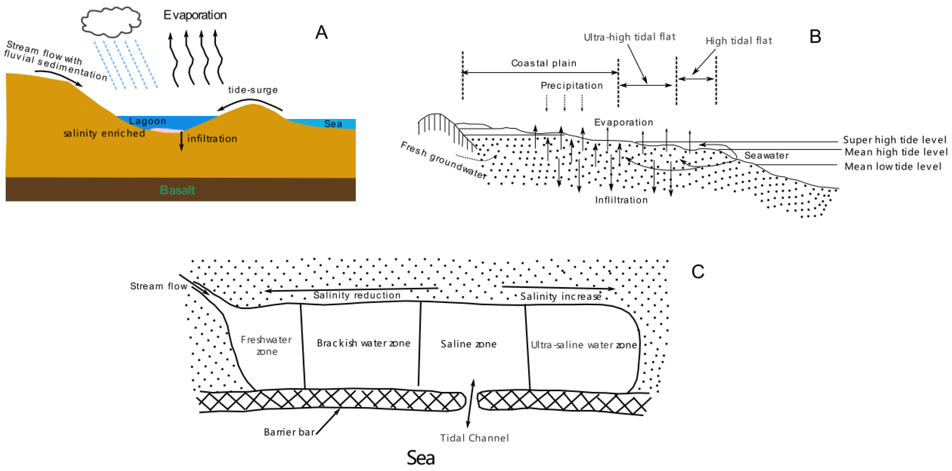
Both the B2-1 and B3-1 brine layers are located in the transitional stage of marine transgression and regression, with relatively low hydrodynamic environments. During the process of regression, residual seawater from marine transgression formed lagoon environments. The relatively arid climate led to a gradual increase in salinity levels within the lagoon, resulting in the formation of early-stage saline water. This process served as a primary mechanism for large-scale underground coastal brine.
(2)
The B3-2 brine layer is located within the marine transgression layer, with relatively weak hydrodynamic conditions. The maximum initiation energy for sediment transport by environmental water flow is relatively stable, while the average kinetic energy of hydrodynamics exhibits significant variability. This indicates an environment heavily influenced by riverine processes, which we classified as a hypersaline environment within a deltaic lagoon. We proposed that the brine formation occurred in a setting that is typically smaller in scale than the residual lagoons formed during marine regression.
(3)
The B1 and B2-2 layers are entirely located within the tidal delta environments, characterized by hydrodynamic conditions consistent with bifurcating river channels. This environment is classified as a low-tide flat. When seawater has sufficient time to evaporate on the vast flat tidal flats, it leads to the downward infiltration and deposition of hypersaline water. With the fluctuation of tides, the sedimentation process of seawater repeats, the underground supersaline water will eventually form and deposit brine.
(4)
For brine to form and be retained, fine-grain-size materials must be deposited under weak hydrodynamic conditions in the strata above and below the brine layer, serving as impermeable layers to protect the brine. River dynamics often influence this process. Overall, the tumultuous interactions between the land and the sea, and the development of river deltas, create favorable conditions for the replenishment, migration, and storage of underground brine resources in the Laizhou Bay area.

Author Contributions

Conceptualization, Q.S. and Y.Y.; methodology, Q.S.; software, W.L. (Wenquan Liu); validation, Q.S. and M.C.; formal analysis, Q.S. and Y.Y.; investigation, T.F.; resources, Q.S.; data curation, W.L. (Wenzhe Lyu); writing—original draft preparation, Y.Y.; writing—review and editing, Q.S.; visualization, M.C.; supervision, Q.S.; project administration, Q.S.; funding acquisition, Q.S. All authors have read and agreed to the published version of the manuscript.

Funding

This research was funded by the Science & Technology Fundamental Resources Investigation Program (2022FY100300) and the National Natural Science Foundation of China (42176213;42276223).

Institutional Review Board Statement

Not applicable.

Informed Consent Statement

Not applicable.

Data Availability Statement

The data presented in this study are available from the corresponding author upon reasonable request.

Acknowledgments

The authors give their most sincere thanks to the editors and reviewers for their contributions to the improvement of this article, and are also grateful for the support of the “observation and research station of seawater intrusion and soil salinization, Laizhou Bay”.

Conflicts of Interest

The authors declare no conflicts of interest.

References

  1. Xiao, X.; Zhang, Y.; Fu, T.; Sun, Z.; Lei, B.; Li, M.; Guo, X. The two salinity peaks mode of marine salt supply to coastal underground brine during a single tidal cycle. Front. Mar. Sci. 2024, 10, 1324163. [Google Scholar] [CrossRef]
  2. Du, Y.; Ma, T.; Chen, L.; Xiao, C.; Liu, C. Chlorine isotopic constraint on contrastive genesis of representative coastal and inland shallow brine in China. J. Geochem. Explor. 2016, 170, 21–29. [Google Scholar] [CrossRef]
  3. Bottomley, D.J.; Katz, A.; Chan, L.H.; Starinsky, A.; Douglas, M.; Clark, I.D.; Raven, K.G. The origin and evolution of Canadian Shield brines: Evaporation or freezing of seawater? New lithium isotope and geochemical evidence from the Slave craton. Chem. Geol. 1999, 155, 295–320. [Google Scholar] [CrossRef]
  4. Starinsky, A.; Katz, A. The formation of natural cryogenic brines. Geochim. Cosmochim. Acta 2003, 67, 1475–1484. [Google Scholar] [CrossRef]
  5. Hanor, J.S.; Mcintosh, J.C. Diverse origins and timing of formation of basinal brines in the Gulf of Mexico sedimentary basin. Geofluids 2007, 7, 227–237. [Google Scholar] [CrossRef]
  6. Bein, A.; Arad, A. Formation of saline groundwaters in the Baltic region through freezing of seawater during glacial periods. J. Hydrol. 1992, 140, 75–87. [Google Scholar] [CrossRef]
  7. Herut, B.; Starinsky, A.; Katz, A.; Bein, A. The role of seawater freezing in the formation of subsurface brines. Geochim. Cosmochim. Acta 1990, 54, 13–21. [Google Scholar] [CrossRef]
  8. Bottomley, D.J.; Conrad Gregoire, D.; Raven, K.G. Saline ground waters and brines in the Canadian Shield: Geochemical and isotopic evidence for a residual evaporite brine component. Geochim. Cosmochim. Acta 1994, 58, 1483–1498. [Google Scholar] [CrossRef]
  9. Curzi, M.; Aldega, L.; Billi, A.; Boschi, C.; Carminati, E.; Vignaroli, G.; Viola, G.; Bernasconi, S.M. Fossil chemical-physical (dis)equilibria between paleofluids and host rocks and their relationship to the seismic cycle and earthquakes. Earth Sci. Rev. 2024, 254, 104801. [Google Scholar] [CrossRef]
  10. Rubey, W.W. Geologic History of Sea Water. Bull. Geol. Soc. Amer. 1951, 62, 1111–1147. [Google Scholar] [CrossRef]
  11. Gerber, C.; Vaikm, E.R.; Aeschbach, W.; Babre, A.; Jiang, W.; Leuenberger, M.; Lu, Z.; Mokrik, R.; Müller, P.; Raidla, V.; et al. Using 81Kr and Noble Gases to Characterize and Date Groundwater and Brines in the Baltic Artesian Basin on the One-Million-Year Timescale. Geochim. Cosmochim. Acta 2017, 205, 187–210. [Google Scholar] [CrossRef]
  12. Klein-BenDavid, O.; Sass, E.; Katz, A. The evolution of marine evaporitic brines in inland basins: The Jordan-Dead Sea Rift valley. Geochim. Cosmochim. Acta 2004, 68, 1763–1775. [Google Scholar] [CrossRef]
  13. Curzi, M.; Caracausi, A.; Rossetti, F.; Rabiee, A.; Billi, A.; Carminati, E.; Aldega, L.; Bernasconi, S.M.; Boschi, C.; Drivenes, K.; et al. From Fossil to Active Hydrothermal Outflow in the Back-Arc of the Central Apennines (Zannone Island, Italy). Geochem. Geophys. Geosystems 2022, 23, e2022GC010474. [Google Scholar] [CrossRef]
  14. Curzi, M.; Bernasconi, S.M.; Billi, A.; Boschi, C.; Aldega, L.; Franchini, S.; Albert, R.; Gerdes, A.; Barberio, M.D.; Looser, N.; et al. U-Pb age of the 2016 Amatrice earthquake causative fault (Mt. Gorzano, Italy) and paleo-fluid circulation during seismic cycles inferred from inter- and co-seismic calcite. Tectonophysics 2021, 819, 229076. [Google Scholar] [CrossRef]
  15. Hardie, L.A.; Eugster, H.P. Evaporation of seawater: Calculated mineral sequences. Sience 1980, 208, 498–500. [Google Scholar]
  16. Lu, H.; Peng, T.; Liou, T. Identification of the origin of salinization in groundwater using multivariate statistical analysis and geochemical modeling: A case study of Kaohsiung, Southwest Taiwan. Environ. Geol. 2008, 55, 339–352. [Google Scholar] [CrossRef]
  17. Yang, F.; Jia, C.; Chang, W.; Yang, H.; Wang, C.; Fan, Q. Integrating hydrochemical and microbial methods to identify hydraulic connections between three saltworks in southern Laizhou Bay, China. Hydrogeol. J. 2022, 30, 1847–1862. [Google Scholar] [CrossRef]
  18. Zhang, Z.; Liu, E.; Zhang, Y.; Xin, L. Environmental evolution in the salt-water intrusion area south of Laizhou Bay since late Pleistocene. J. Geogr. Sci. 2008, 18, 37–45. [Google Scholar] [CrossRef]
  19. Han, Y.; Meng, G.; Wang, S. A preliminary study on the distribution and genesis of underground brine in the littoral plain of Laizhou Bay in the Bohai Sea. Chin. J. Oceanol. Limnol. 1993, 11, 46–56. [Google Scholar]
  20. Han, D.M.; Song, X.F.; Currell, M.J.; Yang, J.L.; Xiao, G.Q. Chemical and isotopic constraints on evolution of groundwater salinization in the coastal plain aquifer of Laizhou Bay, China. J. Hydrol. 2014, 508, 12–27. [Google Scholar] [CrossRef]
  21. Du, Y.; Ma, T.; Chen, L.; Shan, H.; Xiao, C.; Lu, Y.; Liu, C.; Cai, H. Genesis of salinized groundwater in Quaternary aquifer system of coastal plain, Laizhou Bay, China: Geochemical evidences, especially from bromine stable isotope. Appl. Geochem. 2015, 59, 155–165. [Google Scholar] [CrossRef]
  22. He, Z.; Ma, C.; Zhou, A.; Qi, H.; Liu, C.; Cai, H.; Zhu, H. Using hydrochemical and stable isotopic (δ2H, δ18O, δ11B, and δ37Cl) data to understand groundwater evolution in an unconsolidated aquifer system in the southern coastal area of Laizhou Bay, China. Appl. Geochem. 2018, 90, 129–141. [Google Scholar] [CrossRef]
  23. Zhao, N.; Xu, X.; Yu, H.; Yao, J.; Su, Q.; Peng, S. The color reflectance of marine-terrigenous deposits in LZ908 borehole in south coastal plain of the Laizhou Bay. Acta Oceanol. Sin 2011, 30, 53–59. [Google Scholar] [CrossRef]
  24. Yi, L.; Yu, H.; Ortiz, J.D.; Xu, X.; Chen, S.; Ge, J.; Hao, Q.; Yao, J.; Shi, X.; Peng, S. Late Quaternary linkage of sedimentary records to three astronomical rhythms and the Asian monsoon, inferred from a coastal borehole in the south Bohai Sea, China. Palaeogeogr. Palaeoclimatol. Palaeoecol. 2012, 329–330, 101–117. [Google Scholar] [CrossRef]
  25. Yi, L.; Yu, H.; Ortiz, J.D.; Xu, X.; Qiang, X.; Huang, H.; Shi, X.; Deng, C. A reconstruction of late Pleistocene relative sea level in the south Bohai Sea, China, based on sediment grain-size analysis. Sediment. Geol. 2012, 281, 88–100. [Google Scholar] [CrossRef]
  26. Yi, L.; Lai, Z.; Yu, H.; Xu, X.; Su, Q.; Yao, J.; Wang, X.; Shi, X. Chronologies of sedimentary changes in the south Bohai Sea, China: Constraints from luminescence and radiocarbon dating. Boreas 2013, 42, 267–284. [Google Scholar] [CrossRef]
  27. Yao, J.; Yu, H.; Xu, X.; YI, L.; Chen, G.; Su, Q. Paleoenvironmental changes during the late Quaternary as inferred from foraminifera assemblages in the Laizhou Bay. Acta. Oceanol. Sin. 2014, 33, 10–18. [Google Scholar] [CrossRef]
  28. Yi, L.; Deng, C.; Xu, X.; Yu, H.; Qiang, X.; Jiang, X.; Chen, Y.; Su, Q.; Chen, G.; Li, P.; et al. Paleo-megalake termination in the Quaternary: Paleomagnetic and water-level evidence from south Bohai Sea, China. Sediment. Geol. 2015, 319, 1–12. [Google Scholar] [CrossRef]
  29. Tian, M.; Zhu, H.T.; Feng, J.; Zhao, Q.S.; Scholz, M. Evaluation and analysis of underground brine resources in the southern coastal area of Laizhou Bay. IOP conference series. Earth Environ. Sci. 2016, 39, 12033. [Google Scholar]
  30. Gao, M.; Hou, G.; Guo, F. Conceptual Model of Underground Brine Formation in the Silty Coast of Laizhou Bay, Bohai Sea, China. J. Coastal Res. 2016, 74, 157–165. [Google Scholar] [CrossRef]
  31. Jia, C.; Yang, F.; Liu, S.; Wang, C.; Chang, W. Paleoclimatic interpretation in southern Laizhou Bay since the late Pleistocene: Evidence from groundwater and sedimentary strata. Cont. Shelf Res. 2022, 237, 104676. [Google Scholar] [CrossRef]
  32. Huang, X.; Zhang, G. Analysis of River Channel Changes and Sedimentary Environment in the River Downstream of Mihe River. J. Hebei Geo. Univ. 2019, 42, 47–50. (In Chinese) [Google Scholar]
  33. Rajganapathi, V.C.; Jitheshkumar, N.; Sundararajan, M.; Bhat, K.H.; Velusamy, S. Grain size analysis and characterization of sedimentary environment along Thiruchendur coast, Tamilnadu, India. Arab. J. Geosci. 2013, 6, 4717–4728. [Google Scholar] [CrossRef]
  34. Folk, R.L.; Ward, W.C. Brazos River bar: A study in the significance of grain size parameters. J. Sed. Pet. 1957, 27, 3–26. [Google Scholar] [CrossRef]
  35. Mutaqin, B.W.; Isnain, M.N.; Ningsih, R.L.; Darmawan, H. Suratman Grain size and sedimentation process in the Anak Krakatau coastal area of Indonesia. Results Earth Sci. 2024, 2, 100018. [Google Scholar] [CrossRef]
  36. Sahu, B.K. Depositional mechanisms from the size analysis of clastic sediments. J. Sediment. Petrol. 1964, 34, 73–83. [Google Scholar]
  37. Passega, R. Texture as characteristic of clastic deposition. Bull. Am. Assoc. Pet. Geol. 1957, 41, 152–1984. [Google Scholar]
  38. Passega, R. Significance of CM diagrams of sediments deposited by suspensions. Sedimentology 1977, 24, 723–733. [Google Scholar] [CrossRef]
  39. Passega, R. Grain size representation by CM patterns as a geologic tool. J. Sediment. Petrol. 1964, 34, 830–847. [Google Scholar] [CrossRef]
  40. Visher, G.S. Grain size distributions and depositional processes. J. Sediment. Petrol. 1969, 39, 1074–1106. [Google Scholar]
  41. Su, Q.; Yu, H.; Xu, X.; Chen, B.; Yang, L.; Fu, T.; Liu, W.; Chen, G. Using Principal Component Analysis (PCA) Combined with Multivariate Change-Point Analysis to Identify Brine Layers Based on the Geochemistry of the Core Sediment. Water 2023, 15, 1926. [Google Scholar] [CrossRef]
  42. Baiyegunhi, T.L.; Liu, K.; Gwavava, O.; Baiyegunhi, C. Textural characteristics, mode of transportation and depositional environment of the Cretaceous sandstone in the Bredasdorp Basin, off the south coast of South Africa: Evidence from grain size analysis. Open Geosci. 2020, 12, 1512–1532. [Google Scholar] [CrossRef]
  43. Yi, L.; Ye, X.; Chen, J.; Li, Y.; Long, H.; Wang, X.; Du, J.; Zhao, S.; Deng, C. Magnetostratigraphy and luminescence dating on a sedimentary sequence from northern East China Sea: Constraints on evolutionary history of eastern marginal seas of China since the Early Pleistocene. Quat. Int. 2014, 349, 316–326. [Google Scholar] [CrossRef]
  44. Yi, L.; Deng, C.; Tian, L.; Xu, X.; Jiang, X.; Qiang, X.; Qin, H.; Ge, J.; Chen, G.; Su, Q.; et al. Plio-Pleistocene evolution of Bohai Basin (East Asia): Demise of Bohai Paleolake and transition to marine environment. Sci. Rep. 2016, 6, 29403. [Google Scholar] [CrossRef]
  45. Lee, S.; Currell, M.; Cendón, D.I. Marine water from mid-Holocene sea level highstand trapped in a coastal aquifer: Evidence from groundwater isotopes, and environmental significance. Sci. Total Environ. 2016, 544, 995–1007. [Google Scholar] [CrossRef]
  46. Barnes, R.S.K. Coastal Lagoons; Cambridge University Press: Cambridge, UK, 1980. [Google Scholar]
  47. Zhang, Y.; Xiao, X.; Sun, Z.; Lei, B.; Li, M.; Guo, X.; Fu, T.; Xing, C. Salt dynamic changes between seawater and phreatic brine in muddy tidal flats under tidal influence. J. Hydrol. 2024, 634, 131044. [Google Scholar] [CrossRef]
Figure 1. The location of core Lz908.This graphic was drawn using GMT6.0 software based on the 5-Minute Gridded Global Relief Data Collection (NOAA).
Jmse 12 02122 g001
Figure 2. The paleo channel of the Mihe River [32].
Jmse 12 02122 g002
Figure 3. Lithology and variation with depth down core Lz908. The lithostratigraphy, sedimentary facies, dating result, and reconstructed reference water level were reported in [28].
Jmse 12 02122 g003
Figure 4. Bivariate plots of grain size parameters. (A) Graphic mean against standard deviation; (B) Graphic mean against skewness; (C) skewness against standard deviation; (D) skewness against kurtosis. Note: The fields of beach, dune, and river environment in (A) are modified from [34,42].
Jmse 12 02122 g004
Figure 5. Bivariate plots of LDFs. (A) Y1 against Y2; (B) Y3 against Y4. Note: The deposition process and environment come from [36].
Jmse 12 02122 g005
Figure 6. CM diagram. The right image is a partially enlarged view of the left image. Note: The determined transportation mode is classified as follows: N–O is rolling, O–P is bottom suspension and rolling, P–Q is rolling and suspension, Q–R is saltation, and R–S is uniform suspension [36].
Jmse 12 02122 g006
Figure 7. Visher diagrams (log-probability plots). (A) comes from [40]. (BF) are the Visher diagrams of the B1, B2-1, B2-2, B3-1, and B3-2 strata, and their upper and lower strata, respectively.
Jmse 12 02122 g007
Figure 8. Conceptual models for the formation of brine. (AC) are drawn based on [45], [19], and [46], respectively.
Jmse 12 02122 g008
Disclaimer/Publisher’s Note: The statements, opinions and data contained in all publications are solely those of the individual author(s) and contributor(s) and not of MDPI and/or the editor(s). MDPI and/or the editor(s) disclaim responsibility for any injury to people or property resulting from any ideas, methods, instructions or products referred to in the content.

