Article

Insights on the Extreme Storm Surge Event of the 22 November 2022 in the Venice Lagoon

1
Italian Institute for Environmental Protection and Research (ISPRA), 00144 Roma, Italy
2
Department of Civil, Environmental, and Architectural Engineering, University of Padova, 35100 Padova, Italy
3
Tide Forecast and Early Warning Center, 30100 Venice, Italy
*
Author to whom correspondence should be addressed.
J. Mar. Sci. Eng. 2023, 11(9), 1750; https://doi.org/10.3390/jmse11091750
Submission received: 10 August 2023 / Revised: 30 August 2023 / Accepted: 1 September 2023 / Published: 7 September 2023

Abstract

:
The Italian Institute for Environmental Protection and Research (ISPRA) manages the national sea state real time monitoring system for Italy, which consists of the National Sea Level Network (RMN), the North Adriatic and Venice Lagoon Sea Level Network (RMLV), the National Wave Networks (RON), and a marine weather forecasting system. These systems are particularly deployed to monitor and predict storm surges that affect the northern part of the Adriatic Sea and the Venice Lagoon, usually causing damages and morphological impacts over the highly anthropized coastal areas. On 22 November 2022, an extreme storm surge event occurred in the northern Adriatic Sea, producing severe damages on its coastline. Venice and the surrounding urban settlements have been protected from flooding thanks to the operation of the Mo.S.E. (Modulo Sperimentale Elettromeccanico) system, a set of artificial barriers built to isolate the lagoon from the sea in case of extreme high tides. Coastal flooding prevention measures, such as storm-surge barriers, are indeed being widely adopted globally because of the accelerating rise in sea levels. An analysis of this extreme event is presented here to highlight the functionality and the usefulness of the ISPRA sea state monitoring system. In particular, the analysis of the as-if scenario reproducing the natural tide propagation within the lagoon, neglecting the operation of the Mo.S.E. system, can only be pursued by using hydrodynamic models forced using extensive observed data. Results highlight that the “not-regulated” sea level would have exceeded 200 cm above the reference datum at Chioggia, a threshold never recorded in the Venice Lagoon since sea level monitoring systems have been operational.

1. Introduction

Extreme storm surge events related to climate change and rising sea levels (SLs) pose relevant flooding and shoreline erosion hazards to many worldwide coastal areas by threatening coastal communities, many of which are expanding through population pressure and tourism [1]. These events cause extensive damage to the local population and assets [2,3,4]. Flooding induced by sea storms represents a major risk to the safety and sustainability of highly anthropized coastal areas [5,6], with particular reference to the north-western coast of the Adriatic Sea, where extreme SLs are among the highest of the Mediterranean Sea, due to the elongated shape of the basin and the shallow waters in its northern part [7,8], and where several cultural World Heritage sites (e.g., the city of Venice and the surrounding historic settlements) are located and threatened [9,10]. The IPCC Sixth Assessment Report on climate change (AR6), published on 9 August 2021, indicates that climate change is worsening the flood threat for worldwide coastal areas [11,12]. In this context, many coastal cities have adopted, as an adaptation strategy, hard protection measures in the form of storm-surge barriers to mitigate flooding risk and preserve the population and assets [13]. Relevant examples are the surge barriers built to protect the Netherlands, the cities of London and Hull in the United Kingdom, St. Petersburg in Russia, New Orleans in Louisiana, and Venice in Italy. Surge barriers are also being proposed to protect Shanghai and New York, as well as Galveston Bay in the United States [14]. Among all these examples, we will focus on the Mo.S.E. (Modulo Sperimentale Elettromeccanico) system in the Venice Lagoon— almost completed and operational under the testing stage since 3 October 2020 [15]. The system consists of a set of movable barriers installed at the three inlets of the Venice Lagoon. Each barrier is made of multiple electromechanical underwater flap gates. The Mo.S.E. barriers, expected to be fully operational by the end of 2024, close the inlets connecting the Venice Lagoon with the Adriatic Sea in times of SL exceeding the safeguard threshold of 110 cm (130 cm in the current testing stage), referring to the official mareographic reference datum of the Punta della Salute gauge (ZMPS), located in the city center of Venice (Figure 1) (refer to Table A1 for the list of surge events faced by the Mo.S.E. system). In the following, SLs will always refer to the Punta della Salute datum. While the national reference datum is fixed, the ZMPS is not because of the not negligible effect of subsidence in Venice. Nowadays, the ZMPS datum is located about 30 cm below the mean SL [15,16]. As storm surge events are becoming increasingly more frequent and hazardous, monitoring networks, together with forecasting systems and other sources of information (e.g., from satellites), are even more fundamental (i) to warn populations early; (ii) to design and manage coastal and offshore works, and to assess their effectiveness; (iii) to maintain and share to stakeholders and decision makers an accurate knowledge of the sea state; and (iv) to reproduce and reforecast the most important storms that occurred in the past under different scenarios [17,18,19,20,21]. On 22 November 2022, the northern Adriatic Sea was exposed to one of the most important marine hazards induced by extreme weather conditions. However, Venice and the other urban settlements within the lagoon were indeed successfully protected by the Mo.S.E. system. After describing and highlighting the importance of the monitoring system developed and managed by ISPRA—Italian Institute for Environmental Protection and Research, we focus here on the weather situation that led to the storm surge event that occurred on 22 November 2022. We then analyze the storm event by simulating via numerical modeling the “what-if” scenario, aimed at reproducing the “not-regulated” hydrodynamics of the Venice Lagoon, i.e., with no Mo.S.E. operation. Simulations are based on the analysis of recorded SLs in and outside the Venice Lagoon and on the simulations produced with a hydrodynamic model, highlighting the extreme SL maxima that would have been reached in the Lagoon in the “not-regulated” scenario.

2. Materials and Methods

2.1. The Study Area and the Flooding Barriers

The Venice Lagoon, Italy, is the largest brackish water body of the Mediterranean Sea, located in the northern part of the Adriatic Sea, which is characterized by important storm surges [8], mainly triggered by south-easterly winds; their effect is enhanced by the shallow water depths, causing severe damages and morphological impacts in its highly anthropized coastal areas. The Venice Lagoon consists of small islands, extensive tidal flats, salt marshes, and a complex network of tidal channels, and it is characterized by a high heterogeneity in physical and biogeochemical conditions provided by mutually interacting habitats [22,23,24]. It is connected to the northern Adriatic Sea through three inlets, namely, from north to south, Lido, Malamocco, and Chioggia, whose widths range from 400 m to 800 m and depths between 6 m and 14 m [22,25]. The average water depth of tide flats is about 1 m, and the most important settlements are Burano, located in the northern lagoon, Venice in the central part, and Chioggia, located in the southern lagoon (Figure 1). The astronomic tidal regime is semidiurnal with a range of about 100 cm. However, the local SL also depends on the barometric pressure, wind, seiches, and unseasonal climate variations [26]. Tide propagation is ruled by the shape of the inlets and by the lagoon morphology, denoting a progressive propagation lag and amplitude reduction proceeding from the inlets towards the lagoon interior. These alterations result in relevant tidal currents. Prevalent winds in the Venice Lagoon are north-easterly (Bora) and south-easterly (Sirocco), of a speed usually up to 20 and 15 m/s, respectively [21,27].

2.2. The Flooding Barriers (Mo.S.E. System)

After the catastrophic events that occurred on 4 November 1966 [2] and 12 November 2019 [28], the Mo.S.E. system has been, respectively, conceived and made operational to protect the lagoon by temporarily separating it from the Adriatic Sea during flood events. It consists of a set of storm surge barriers mounted at the inlets and formed by some independent flap gates hinged on the inlet bottoms (Figure 2; for more technical details see https://www.mosevenezia.eu/progetto/, accessed on 22 November 2022). In normal tidal conditions, the gates rest on the bottom of the inlets full of water; when the SL is expected to exceed the safeguard threshold, compressed air is pumped into the flap gates, allowing them to rotate upwards, interrupting the entering flow rate [29]. The safeguard threshold, defined as the SL that should not be exceeded during high tides [16], is set to 110 cm at Venice and Burano and 130 cm at Chioggia, the latter being protected by a local system of gates installed in the main canal of the historical city center.

2.3. The Monitoring System

The SL and wind characteristics used in the present work were provided by the national marine monitoring system for Italy developed and managed by ISPRA—Italian Institute for Environmental Protection and Research. This monitoring system includes the National Sea Level Measurement Network (RMN), consisting of 36 stations, and the North Adriatic and Venice Lagoon Sea Level Measurement Network (RMLV), consisting of 29 tide gauges, as well as the National Wave Network (RON). In this framework, ISPRA monitors, analyses, and provides the physical state of the territorial sea with a very fine spatial and temporal resolution. Furthermore, ISPRA regularly improves and upgrades its monitoring system, which is also complemented by a marine weather forecasting system [30,31]. All data are open access to the scientific community, authorities, stakeholders, and decision makers for monitoring, modelling, forecasting, and early warning purposes. During the extreme storm surge event that occurred on 22 November 2022, characterized by high spatial and temporal variability of the meteorological conditions, the capillary distribution of ISPRA meteorological–marine gauges located in the Venice Lagoon and in the northern Adriatic Sea allowed for a detailed analysis of the event. In this study, the data from ISPRA networks were supplemented with those provided by the Environmental Protection Agencies of Veneto Region (ARPAV) and Friuli Venezia Giulia Region (ARPA FVG), and by the Tide Forecasting and Reporting Center of the Municipality of Venice (CPSM).

2.4. The WWTM Hydrodynamic Model and Simulation Setup

We carried out the mathematical simulations by means of the WWTM [32,33]. WWTM is a two-dimensional coupled wind–wave tidal model developed at the Department of Civil, Environmental and Architectural Engineering of the University of Padova, which has been applied in other tidal environments (e.g., [14,34]). WWTM solves the 2-D shallow water equations suitably modified to deal with wetting and drying processes [32]. It uses a semi-implicit staggered numerical scheme based on Galerkin’s approach [35], allowing for the use of 2-D elements with different shapes and sizes, providing high flexibility in the spatial discretization of complex geometries, typical of shallow water basins. The wind–wave generation and propagation are computed by solving the wave action conservation equation parameterized using the zero-order moment of the wave action spectrum in the frequency domain. The spatial variability of the wind field is accounted for by adopting the interpolation technique proposed in [36]. WWTM was used to reproduce tide propagation and wind setup in the “what-if” not-regulated scenario (i.e., neglecting the raising of the Mo.S.E. system barriers). The computational grid used for the numerical simulations reproduced the present configuration of the Venice Lagoon and a small portion of the Adriatic Sea in front of the three inlets by means of about 100,000 triangular elements. The representative size of the 2-D elements ranges from about 100 m (in tidal flats) to 10 m (at the inlets, where the spatial gradients of the velocity are prominent). The elevation was assigned on the basis on the most recent bathymetry provided by the ex-Venice Water Authority. The Strickler bed roughness coefficient (Ks) was calibrated [33,37] to effectively reproduce the energy dissipation experienced by the tide propagating within the lagoon. The capability of the model to properly reproduce the lagoon hydrodynamics, also under intense stormy conditions, when the wind shear stress at the free surface did not negligibly affect the tide propagation, was widely calibrated and tested by performing a large set of numerical simulations (e.g., [1,37]), showing absolute errors in the estimation of the water levels, generally comparable to the precision of the lagoonal tide gauges (i.e., lower than 2–3 cm).
In the present work, we forced the WWTM by imposing the tidal signal measured at the seaward stations at the three inlets (i.e., Diga Sud Lido, Diga Nord Malamocco, and Diga Sud Chioggia). The spatial and temporal distribution of the wind field was reconstructed following the approach described in [38] and considering the wind climate gauged at three ISPRA stations, namely, from north to south, Grassabò, San Giorgio in Alga, and Petta de Bo (Figure 1).

3. Results and Discussion

During the present testing phase of the Mo.S.E. system, which is planned to last from June 2020 to December 2024, the barriers raise when the SL forecast exceeds the threshold value of 130 cm at Punta della Salute or Chioggia. We note that, due to a safety margin adopted to take into account the forecast uncertainty, the barriers prevented all the SLs higher than 110 cm in the Venice Lagoon.
This condition occurred in the morning of 22 November 2022. Both the weather and SL forecasts for this storm event were particularly reliable with a lead-time of several days, as noted by the Technical Board for storm-surge events, composed of CPSM, ISPRA, and CNR-ISMAR, which always meets in case of an SL forecast exceeding 110 cm and issues an official bulletin providing the SL forecasts computed using a set of statistical and hydrodynamic models.

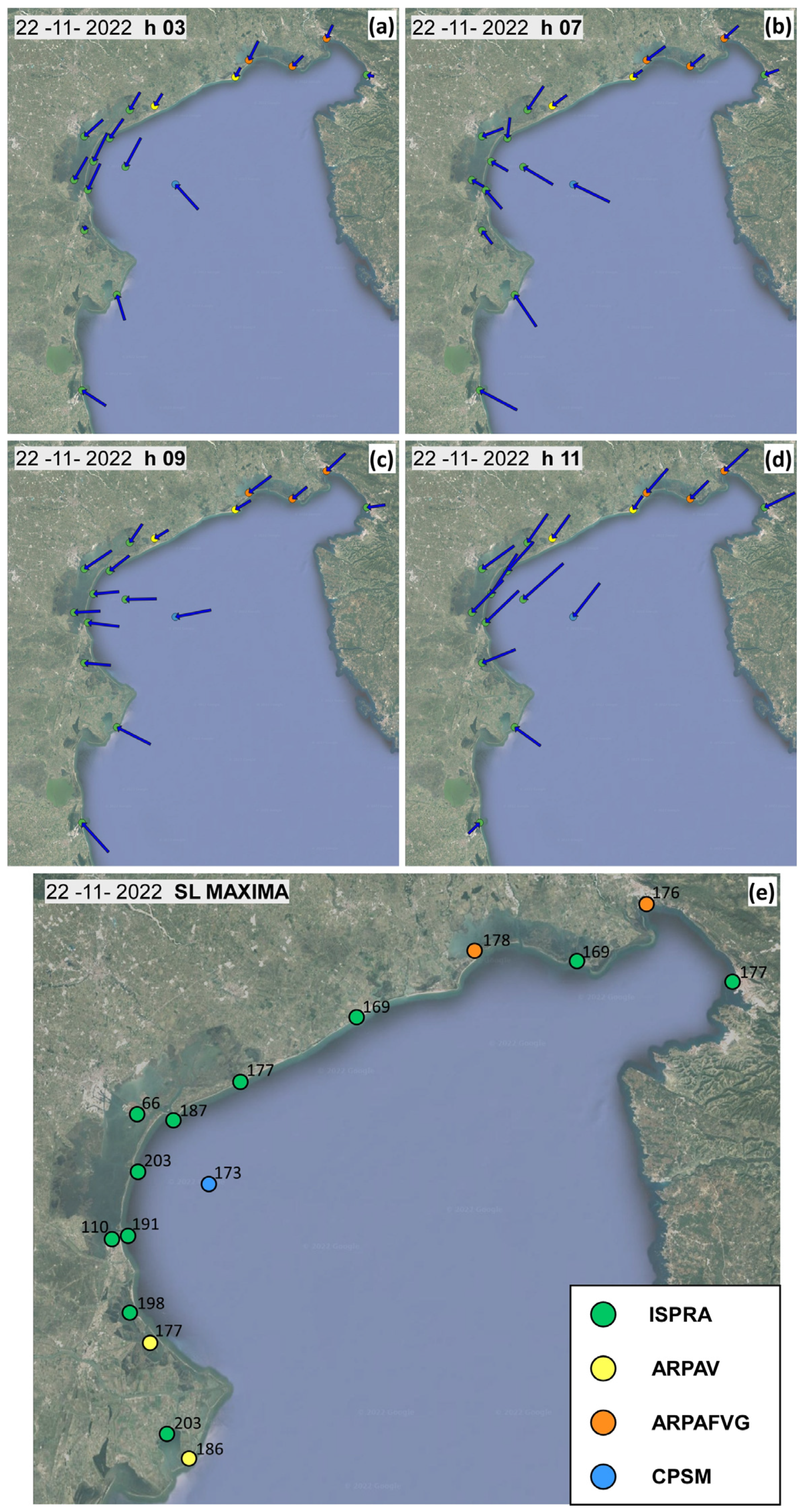
3.1. 22 November 2022—Analysis of the Event

Starting from the middle of November 2022, a large semi-stationary upper-level cyclonic system hit the western and northern parts of Europe. As is typical during the fall, the passage of a large-scale trough over the Alps produced, in the night of 21 November, an intense cyclonic circulation system (secondary cyclone, see [39]) characterized by a deep surface pressure minimum and slow eastward motion. The presence of two stationary high-pressure zones, one located over the Atlantic Ocean and the other over Eastern Europe, contributed to a delay and squeeze of the cyclone, enhancing the strong upper-level meridional flow on the eastern side of the trough produced by dense isobars (Figure 3). This configuration, with two blocking anticyclones, is particularly common in this period in the Mediterranean area and characterizes the strongest tide phenomena in the Venice coastline [40]. Between 21 and 22 November, the ground-level pressure minimum moved from the Genoa Gulf over the central part of Italy, deepening to almost 985 hPa (Figure 3a), and triggering intense south-easterly surface winds over the Adriatic Sea (Figure 3b), enhanced by the channeling effect provided by the mountain ranges bordering the basin (Apennines to the west and Dinaric Alps to the east), along with intense north-eastern surface winds (i.e., Bora wind) over the northern part of the basin, including the Venice Lagoon (Figure 4). At the CNR platform gauge, on 22 November, the average wind speed exceeded 20 m/s, with wind gusts over 30 m/s.
The above meteorological scenario resulted in an SL maximum of 173 cm at the CNR platform at 9.35 UTC+1, with a significant wave height of about 4.5 m. Although the surge residual (i.e., the difference between the observed water level and astronomical tide) was about one meter in the whole northern Adriatic Sea, along the Venetian coast, the largest SLs were recorded (e.g., 169 cm at Grado, 177 cm at Trieste, 198 at Porto Caleri, and 203 cm at Malamocco Diga Nord and at Sacca Scardovari gauges), mostly caused by the local wind–wave setup and enhanced by the timing of astronomical and meteorological contributions (Figure 4 and Figure 5).
The Mo.S.E. barriers started raising at 2:00 UTC+1, actually disconnecting the lagoon from the sea in about 30 min—time needed to rise the gates up to the sea surface. The closure of the inlets limited the SL at the Punta della Salute gauge to 70 cm only. At Chioggia Vigo, located in the southern lagoon, the SL reached 110 cm, with an extreme SL difference between Chioggia Vigo and Punta della Salute (about 60 cm), due to the Bora wind setup effect (Figure 5b), confirming that the cross-lagoon wind setup is magnified when the lagoon is temporarily closed (see [1]). The SL difference between the gauges located along the Venetian coastline and within the lagoon reached a maximum of about 150 cm between 09 and 12 UTC+1. Although the SLs gauged within the Venice Lagoon cannot be comparable to other surge events due to the operation of the Mo.S.E. system, it is valuable to point out that the SL maxima at the gauges located in the northern Adriatic Sea are similar to those recorded during the two catastrophic storm surge events that occurred on 12 November 2019 and on 4 November 1966. During those events, the Mo.S.E. barriers were not operational, and Venice and the other urban settlements located in the lagoon experienced devastating floods, which compromised local activities and tourism and produced millions of Euros worth of damage and widespread disruption that led some inhabitants to leave the city [29].

3.2. 22 November 2022—The “What-If” Scenario

Since October 2020 (i.e., since when the Mo.S.E. became operational), SL time series recorded within the Venice Lagoon have been affected by the closure of the inlets during storm surge events. SLs that the lagoon would have naturally experienced in a “what-if”, not-regulated scenario neglecting the operation of the Mo.S.E. barriers can only be estimated by using hydrodynamic models (see also [15]). In the present study, we used the WWTM model to simulate the not-regulated scenario. Reconstructing the not-regulated SL time series within the lagoon during the storm events is not a pure modelling exercise but it is crucial (i) for the Mo.S.E. barrier operational management actually based on storm surge prediction at prescribed lagoonal gauges; (ii) to assess the real effect of the Mo.S.E. system in reducing SL peaks; and (iii) to investigate possible changes in lagoon hydrodynamics.
Results reported in Figure 6a refer to the SL gauges of Punta della Salute, Chioggia Vigo, and Burano, comparing the observed SLs to the SLs computed with the WWTM model simulating the not-regulated scenario. Each gauge is characterized by an SL peak, under the not-regulated scenario, higher than 140 cm, which corresponds to the highest hazard threshold of the flood risk management procedure, as defined by the CPSM. The Mo.S.E. system reduced the SL peak by 93 cm at Chioggia Vigo, 112 at Punta della Salute, and 105 cm at Burano. Interestingly, our results suggest that the SL peak computed at Chioggia Vigo under the not-regulated scenario (i.e., 203 cm) would have been the highest SL ever recorded in the Venice Lagoon (Figure 6a).
The numerical analysis further confirms that the wind setup within the Venice Lagoon is importantly enhanced when the lagoon is temporarily closed. Looking for an example regarding the difference in SLs between Chioggia Vigo and Punta della Salute and between Chioggia Vigo and Burano, it is more than two times larger during the closure of the Mo.S.E. barriers than under the not-regulated scenario (Figure 6b). Notably, such an increase in wind setup when the lagoon is artificially separated from the sea nicely meets the results in [1,15] based on modelling results made before the Mo.S.E. became operational, i.e., when the regulated lagoon was still a “what-if” scenario.

4. Conclusions

This work presents a case study of one of the most important activities in charge of the Italian Institute for Environmental Protection and Research (ISPRA) concerning flooding risk and management (see Floods Directive 2007/60/EC). The integrated monitoring and forecasting system managed by ISPRA is used to describe the physical state of the sea, with the aim to assess and mitigate the impact of storm surges. The example of the extreme storm surge event that occurred on 22 November 2022 in the northern Adriatic Sea, which shows high variability in the meteorological–marine parameters both in space and time, highlights the importance of a diffuse monitoring network and of a high-resolution operational forecasting system. Ex-post modelling analyses, based on the hydrodynamic model WWTM, showed that, without the operation of the Mo.S.E. system, the SL in the Venice Lagoon during the November 2022 event would have been the highest ever recorded, with a tidal peak of 203 cm above ZMPS at Chioggia Vigo. The data further confirm that the cross-lagoon wind setup is magnified when the lagoon is temporarily closed, highlighting that, in the not-regulated scenario, the fluxes through the three inlets help to reduce the SL gradient within the basin. We note that, although the effect of raising the Mo.S.E. barriers on the SLs recorded along the north-western Adriatic Sea coastline is beyond the aim of this work, it is worth investigating the possible higher water levels recorded during storms when the Mo.S.E. system is operational. This further analysis will support the reliability of the SL time series recorded at the gauges located seaward of the Mo.S.E. barriers and will improve the accuracy of the SL estimation within the lagoon under the undisturbed scenario (i.e., the SLs computed as described in Section 3.2, where the mathematical model is fed by the seaward SLs). It is also worthwhile to stress that the outcomes of both the monitoring network and of the forecasting system produced by ISPRA are available to all stakeholders. This allows for sharing the potential of the ISPRA integrated monitoring and forecasting system with the scientific community and with the local authorities in charge of environmental monitoring and protection, being a fundamental tool to support the management of the marine environment, with particular reference to the coastal areas located in the northern Adriatic Sea.

Author Contributions

Conceptualization, R.A.M., A.B. and M.F.; methodology, R.A.M., A.B. and M.F.; software, R.A.M. and L.C.; validation, all authors; formal analysis, all authors; investigation, all authors; data curation, all authors; writing—original draft preparation, R.A.M.; writing—review and editing, all authors; supervision, A.B. and M.F. All authors have read and agreed to the published version of the manuscript.

Funding

This research received no external funding.

Institutional Review Board Statement

Not applicable.

Informed Consent Statement

Not applicable.

Data Availability Statement

The use of the hydrodynamic model WWTM shall be subject to specific authorization. More information is available by contacting the corresponding author. All the data used in the paper are available by contacting the corresponding author.

Conflicts of Interest

The authors declare no conflict of interest.

Appendix A

The following is the list of surge events that reached or exceeded the SL threshold of 110 cm at the CNR-platform gauge faced by the deployment of the Mo.S.E. system within the period October 2020–August 2023.
Table A1. Characteristics of surge events at CNR platform (date, time, and recorded SL peak; grey color) with SL peak ≥ 110 cm and that have been faced with the raising of the Mo.S.E. barriers to limit the SL in the Venice Lagoon. For the same events, Punta della Salute SL peaks are reported in red color. The right column reports the SL peak difference between CNR platform and Punta della Salute thanks to the Mo.S.E. deployment.
No EventDate
CNR Platform
Peak Time (CET)
CNR Platform
SL Peak (cm)
CNR Platform
SL Peak (cm)
Punta Della Salute
SL Peak
Difference
13 October 2020 11:101197742
215 October 202009:051326567
316 October 2020 09:151115358
42 December 2020 09:451247450
55 December 2020 00:501228141
65 December 2020 10:501148529
76 December 2020 00:451208733
86 December 202014:101239528
99 December 2020 08:101138429
1010 December 2020 07:201227844
1111 December 2020 06:451247747
1212 December 2020 07:301137637
1328 December 2020 10:101287553
1430 December 2020 09:101107931
159 February 202108:3011610313
1610 February 202108:351277849
171 November 202120:551238340
182 November 202120:401166650
193 November 202119:551326072
206 November 202109:501117140
211 December 202107:251177740
222 December 202107:201206753
235 December 202109:101137241
249 December 202100:251108030
254 November 202208:401137439
265 November 202207:45 1106743
2722 November 202209:4017367106
2823 November 202209:201425389
2924 November 202209:001346569
3025 November 202209:251146351
314 December 202207:101217249
3216 December 202202:451178235
3321 January 202308:301247054
3422 January 202309:301148133
3523 January 202310:451356174
3628 August 202319:301158827

References

  1. Mel, R.A.; Carniello, L.; D’Alpaos, L. Addressing the effect of the Mo.S.E. barriers closure on wind setup within the Venice lagoon. Estuar. Coast. Shelf Sci. 2019, 225, 106249. [Google Scholar] [CrossRef]
  2. De Zolt, S.; Lionello, P.; Nuhu, A.; Tomasin, A. The disastrous storm of 4 November 1966 on Italy. Nat. Hazards Earth Syst. Sci. 2006, 6, 861–879. [Google Scholar] [CrossRef]
  3. Kortekaas, S.; Dawson, A.G. Distinguishing tsunami and storm deposits: An example from Martinhal, SW Portugal. Sediment. Geol. 2007, 200, 208–221. [Google Scholar] [CrossRef]
  4. Rodríguez-Ramírez, A.; Pérez-Asensio, J.N.; Santos, A.; Jiménez-Moreno, G.; Villarías-Robles, J.J.R.; Mayoral, E.; Celestino-Pérez, S.; Cerrillo-Cuenca, E.; López-Sáez, J.A.; León, A.; et al. Atlantic extreme wave events during the last four millennia in the Guadalquivir Estuary. SW Spain. Quat. Res. 2015, 83, 24–40. [Google Scholar] [CrossRef]
  5. Spencer, T. Submerging Coasts: The Effects of a Rising Sea Level on Coastal Environments; Bird, E.C.F., Ed.; John Wiley and Sons: Chichester, UK, 1993. [Google Scholar]
  6. Pirazzoli, P.A.; Umgiesser, G. The projected MOSE barriers against flooding in Venice (Italy) and the expected global sea-level rise. J. Mar. Environ. Eng. 2006, 8, 247–261. [Google Scholar]
  7. Ferrarin, C.; Valentini, A.; Vodopivec, M.; Klaric, D.; Massaro, G.; Bajo, M.; De Pascalis, F.; Fadini, A.; Ghezzo, M.; Menegon, S.; et al. Integrated sea storm management strategy: The 29 October 2018 event in the Adriatic Sea. Nat. Hazards Earth Syst. Sci. 2020, 20, 73–93. [Google Scholar] [CrossRef]
  8. Marcos, M.; Tsimplis, M.N.; Shaw, A.G.P. Sea level extremes in southern Europe. J. Geophys. Res. 2009, 144, C01007. [Google Scholar] [CrossRef]
  9. Prahl, B.F.; Boettle, M.; Costa, L.; Kropp, J.P.; Rybski, D. Damage and protection cost curves for coastal floods within the 600 largest European cities. Sci. Data 2018, 5, 180034. [Google Scholar] [CrossRef]
  10. Reimann, L.; Vafeidis, A.T.; Brown, S.; Hinkel, J.; Tol, R.S.j. Mediterranean UNESCO World Heritage at risk from coastal flooding and erosion due to sea-level rise. Nat. Commun. 2018, 9, 4161. [Google Scholar] [CrossRef]
  11. Taherkhani, M.; Vitousek, S.; Barnard, P.L.; Frazer, N.; Anderson, T.T.; Fletcher, C.H. Sea-level rise exponentially increases coastal flood frequency. Sci. Rep. 2020, 10, 6466. [Google Scholar] [CrossRef]
  12. Mel, R.A.; Lo Feudo, T.; Micieli, M.; Sinopoli, S.; Maiolo, M. A coupled wave-hydrodynamical model to assess the effect of Mediterranean storms under climate change: The Calabaia case study. Dyn. Atm. Ocean. 2023, 102, 101368. [Google Scholar] [CrossRef]
  13. Vousdoukas, M.I.; Mentaschi, L.; Hinkel, J.; Ward, P.J.; Mongelli, I.; Ciscar, J.-C.; Feyen, L. Economic motivation for raising coastal flood defenses in Europe. Nat Commun. 2020, 11, 2119. [Google Scholar] [CrossRef] [PubMed]
  14. Tognin, D.; Finotello, A.; D’alpaos, A.; Viero, D.P.; Pivato, M.; Mel, R.A.; Defina, A.; Bertuzzo, E.; Marani, M.; Carniello, L. Loss of geomorphic diversity in shallow tidal embayments promoted by storm-surge barriers. Sci. Adv. 2022, 8, eabm8446. [Google Scholar] [CrossRef] [PubMed]
  15. Mel, R.; Carniello, L.; Viero, D.P.; Defina, A.; D’Alpaos, L. The first operations of Mo.S.E. system to prevent the flooding of Venice: Insights on the hydrodynamics of a regulated lagoon. Estuar. Coast. Shelf Sci. 2021, 261, 107547. [Google Scholar] [CrossRef]
  16. Umgiesser, G. The impact of operating the mobile barriers in Venice (MOSE) under climate change. J. Nat. Conserv. 2020, 54, 125783. [Google Scholar] [CrossRef]
  17. Morucci, S.; Picone, M.; Nardone, G.; Arena, G. Tides and waves in the Central Mediterra-nean Sea. J. Oper. Oceanogr. 2016, 9 (Suppl. S1), s10–s17. [Google Scholar] [CrossRef]
  18. De Biasio, F.; Bajo, M.; Vignudelli, S.; Umgiesser, G.; Zecchetto, S. Improvements of storm surge forecasting in the Gulf of Venice exploiting the potential of satellite data: The ESA DUE eSurge-Venice project. Eur. J. Remote Sens. 2017, 50, 428–441. [Google Scholar] [CrossRef]
  19. Di Nunno, F.; Granata, F.; Gargano, R.; De Marinis, G. Forecasting of extreme storm tide events using NARX neural network-based models. Atmosphere 2021, 12, 512. [Google Scholar] [CrossRef]
  20. Granata, F.; Di Nunno, F. Artificial Intelligence models for prediction of the tide level in Venice. Stoch. Environ. Res. Risk Assess. 2021, 35, 2537–2548. [Google Scholar] [CrossRef]
  21. Umgiesser, G.; Bajo, M.; Ferrarin, C.; Cucco, A.; Lionello, P.; Zanchettin, D.; Papa, A.; Tosoni, A.; Ferla, M.; Coraci, E.; et al. The prediction of floods in Venice: Methods, models and uncertainty. Nat. Hazards Earth Syst. Sci. 2021, 21, 2679–2704. [Google Scholar] [CrossRef]
  22. Carniello, L.; Defina, A.; D’Alpaos, L. Morphological evolution of the Venice Lagoon: Evidence from the past and trend for the future. J. Geophys. Res. Earth Surf. 2009, 114, F04002. [Google Scholar] [CrossRef]
  23. Finotello, A.; Lanzoni, S.; Ghinassi, M.; Marani, M.; Rinaldo, A.; D’Alpaos, A. Migration rates of tidal meanders. Proc. Natl. Acad. Sci. USA 2018, 115, 1463–1468. [Google Scholar] [CrossRef] [PubMed]
  24. Molinaroli, E.; Guerzoni, S.; Sarretta, A.; Masiol, M.; Pistolato, M. Thirty-year changes (1970–2000) in bathymetry and sediment texture recorded in the lagoon of Venice sub-basins, Italy. Mar. Geol. 2009, 258, 115–125. [Google Scholar] [CrossRef]
  25. Mel, R. Exploring the partial use of the Mo.S.E. system as effective adaptation to rising flood frequency of Venice. Nat. Hazards Earth Syst. Sci. 2021, 21, 3629–3644. [Google Scholar] [CrossRef]
  26. Robinson, A.R.; Tomasin, A.; Artegiani, A. Flooding of Venice, phenomenology and prediction of the Adriatic storm surge. Q. J. R. Meteorol. Soc. 1973, 99, 688–692. [Google Scholar] [CrossRef]
  27. Mel, R.; Carniello, L.; D’Alpaos, L. How long the Mo.S.E. barriers will be effective in pro-tecting all urban settlements within the Venice Lagoon? The wind setup constraint. Coast. Eng. 2021, 168, 103923. [Google Scholar] [CrossRef]
  28. Cavaleri, L.; Bajo, M.; Barbariol, F.; Bastianini, M.; Benetazzo, A.; Bertotti, L.; Chiggiato, J.; Ferrarin, C.; Trincardi, F.; Umgiesser, G. The 2019 flooding of Venice and its implications for future predictions. Oceanography 2020, 33, 42–49. [Google Scholar] [CrossRef]
  29. Gentilomo, M.; Cecconi, G. Flood protection system designed for Venice. Hydropower Dams 1997, 2, 46–52. [Google Scholar]
  30. Mariani, S.; Casaioli, M.; Coraci, E.; Malguzzi, P. A new high-resolution BOLAM-MOLOCH suite for the SIMM forecasting system: Assessment over two HyMeX intense observation periods. Nat. Hazards Earth Syst. Sci. 2015, 15, 1–24. [Google Scholar] [CrossRef]
  31. Morucci, S.; Coraci, E.; Crosato, F.; Ferla, M. Extreme events in Venice and in the North Adriatic Sea: 28–29 October 2018. Rend. Lincei Sci. Fis. Nat. 2020, 31, 113–122. [Google Scholar] [CrossRef]
  32. Defina, A. Two-dimensional shallow equations for partially dry areas. Water Resour. Res. 2000, 36, 3251. [Google Scholar] [CrossRef]
  33. Carniello, L.; Defina, A.; Fagherazzi, S.; D’Alpaos, L. A combined wind wave-tidal model for the Venice lagoon, Italy. J. Geophys. Res. 2005, 110, F04007. [Google Scholar] [CrossRef]
  34. Zarzuelo, C.; Lopez-Ruiz, A.; D’Alpaos, A.; Carniello, L.; Ortega-Sanchez, M. Assessing the morphodynamic response of human-altered tidal embayments. Geomorphology 2018, 320, 127–141. [Google Scholar] [CrossRef]
  35. D’Alpaos, L.; Defina, A. Mathematical modeling of tidal hydrodynamics in shallow lagoons: A review of open issues and applications to the Venice lagoon. Comput. Geosci. 2007, 33, 476–496. [Google Scholar] [CrossRef]
  36. Brocchini, M.; Wurtele, M.; Umgiesser, G.; Zecchetto, S. Calculation of a mass consistent two-dimensional wind-field with divergence control. J. Appl. Meteorol. 1995, 34, 2543–2555. [Google Scholar] [CrossRef]
  37. Carniello, L.; D’Alpaos, A.; Defina, A. Modeling wind-waves and tidal flows in shallow microtidal basins. Estuar. Coast. Shelf Sci. 2011, 92, 263–276. [Google Scholar] [CrossRef]
  38. Carniello, L.; Defina, A.; D’Alpaos, L. Modeling sandmud transport induced by tidal currents and wind waves in shallow microtidal basins: Application to the Venice Lagoon (Italy). Estuar. Coast. Shelf Sci. 2012, 102–103, 105–115. [Google Scholar] [CrossRef]
  39. Speranza, A.; Buzzi, A.; Trevisan, A.; Malguzzi, P. A Theory of Deep Cyclogenesis in the Lee of the Alps: Modifications of Baroclinic Instability by Localized Topography. J. Atmos. Sci. 1985, 42, 1521–1535. [Google Scholar] [CrossRef]
  40. Cavaleri, L.; Bajo, M.; Barbariol, F.; Bastianini, M.; Benetazzo, A.; Bertotti, L.; Chiggiato, J.; Davolio, S.; Ferrarin, C.; Magnusson, L.; et al. The October 29, 2018 storm in Northern Italy—An exceptional event and its modeling. Prog. Oceanogr. 2019, 178, 102178. [Google Scholar] [CrossRef]
  41. Buzzi, A.; Fantini, M.; Malguzzi, P.; Nerozzi, F. Validation of a limited area model in cases of Mediterranean cyclogenesis: Surface fields and precipitation scores. Meteorol. Atmos. Phys. 1994, 53, 53–67. [Google Scholar] [CrossRef]
  42. Malguzzi, P.; Grossi, G.; Buzzi, A.; Ranzi, R.; Buizza, R. The 1996 “century” flood in Italy. A meteorological and hydrological revisitation. J. Geophys. Res. 2006, 111, D24106. [Google Scholar] [CrossRef]
Figure 1. The Adriatic Sea (bottom right) and the Venice Lagoon (main panel) with the main meteorological stations (green bullets) and tide stations used in the present work (red bullets): the lagoonal gauges of Grassabò, Burano, Punta della Salute, and Chioggia, and Diga Sud Lido, Diga Nord Malamocco, and Diga Sud Chioggia gauges, located seaward close to the inlet dams (grey bullets). Black bullets represent a CNR platform, located about 15 km in front of the Venice Lagoon, Trieste, Grado, Porto Caleri, and Scardovari. Thick black lines show the location of the Mo.S.E. barriers.
Jmse 11 01750 g001
Figure 2. Mo.S.E. system at the Malamocco inlet; (a) picture of the seaward side of the barrier raised on 28 December 2020 (source of the picture: private archive of the corresponding author); (b) working position of a single flap gate belonging to the Malamocco barrier. Lengths are expressed in meters (m) and elevations in meters above the reference datum of Punta della Salute (ZMPS).
Jmse 11 01750 g002
Figure 3. Run of 21 November 2022, 12 UTC (initialization) valid for 22 November at 09 UTC provided by the ISPRA SIMM meteorological forecasting system. Source: SIMM forecast website https://www.isprambiente.gov.it/pre_meteo_eng/, accessed on 22 November 2022 (weather forecasts are accessible on the website 2 months after their issue, thereafter upon request). (a) Mean sea level pressure forecast (from BOLAM model [30,41]) and (b) 10-m wind forecast (from MOLOCH model [30,42]).
Jmse 11 01750 g003
Figure 4. 22 November 2022, northern Adriatic Sea gauges. Wind climate in different times ((a) 03 UTC+1; (b) 07 UTC+1; (c) 09 UTC+1; (d) 11 UTC+1). (e) SL maxima. Data were provided by ISPRA (green bullets), ARPAV (yellow), ARPAFVG (orange), and CPSM (blue).
Jmse 11 01750 g004
Figure 5. 22 November 2022. (a) Observed SLs (solid blue lines) at the seaward gauges of the northern Adriatic Sea (Grado; Caorle; Malamocco Diga Nord; Porto Caleri; and Scardovari); (b) observed SLs at the four lagoonal gauges (Grassabò, purple; Burano, red; Punta della Salute, orange; and Chioggia Vigo, green). SL lagoonal data are compared to those recorded at the CNR platform (dashed grey lines).
Jmse 11 01750 g005
Figure 6. 22 November 2022. (a) SLs computed at Chioggia Vigo (green), Punta della Salute (orange), and Burano (red) under the not-regulated (without Mo.S.E.) scenario. Shaded lines represent the observed SLs also shown in Figure 5b; the dashed line represents the observed SL at the CNR platform. (b) Scatter plot of wind setup (ΔSL) with and without Mo.S.E. between Chioggia Vigo and Punta della Salute (orange) or Chioggia Vigo and Burano (red), within the same time window (12–14 UTC+1).
Jmse 11 01750 g006
Disclaimer/Publisher’s Note: The statements, opinions and data contained in all publications are solely those of the individual author(s) and contributor(s) and not of MDPI and/or the editor(s). MDPI and/or the editor(s) disclaim responsibility for any injury to people or property resulting from any ideas, methods, instructions or products referred to in the content.

