
In Situ Radioactivity Maps and Trace Metal Concentrations in Beach Sands of a Mining Coastal Area at North Aegean, Greece

 ,
,  , ,
, ,
Abstract
1. Introduction
2. Material and Methods
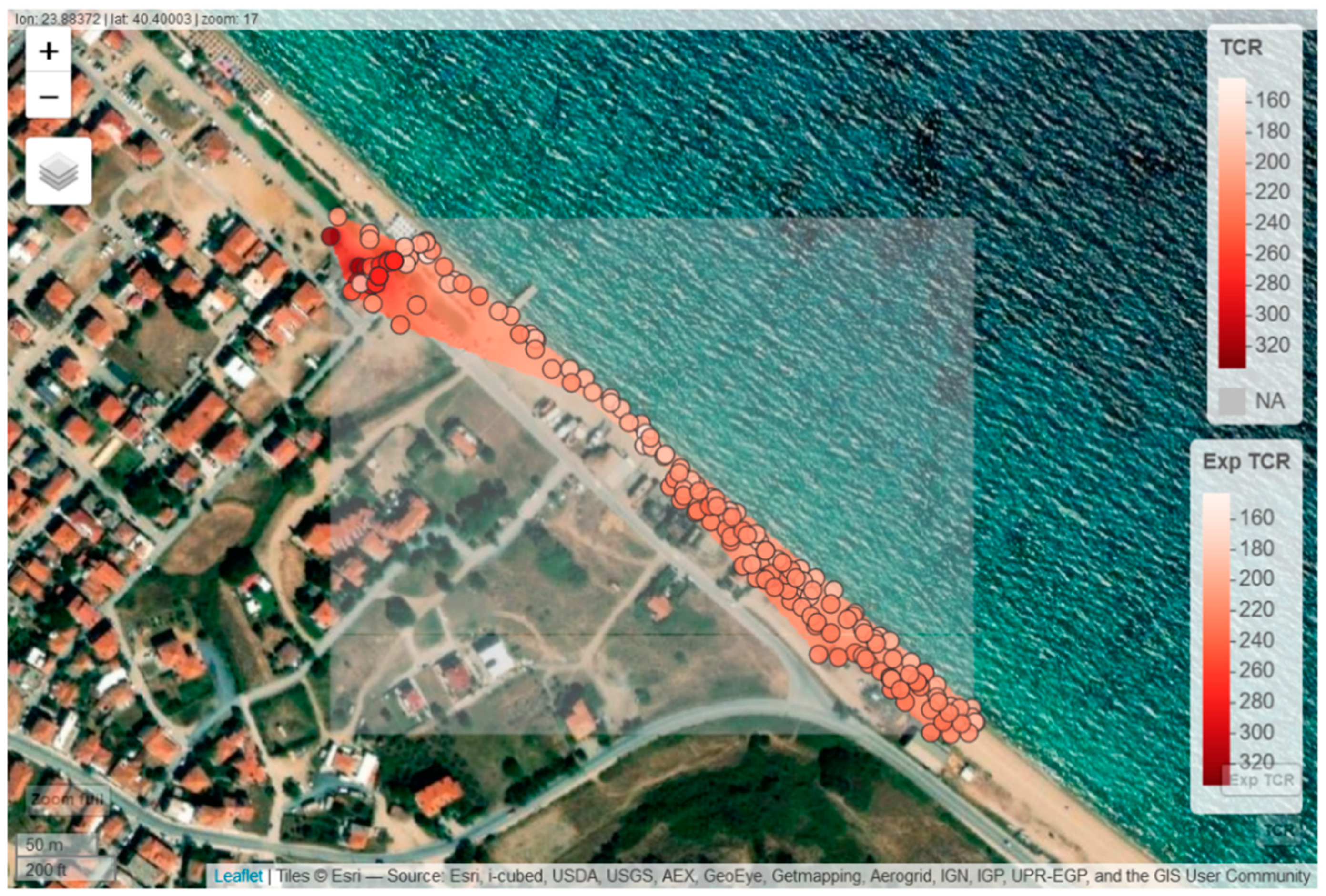
2.1. Study Area and Fieldwork
2.2. KATERINA II Detection System
2.3. Field Work and Lab-Based Techniques
2.4. Mapping Method
2.5. Dose Rate Assessment
3. Results
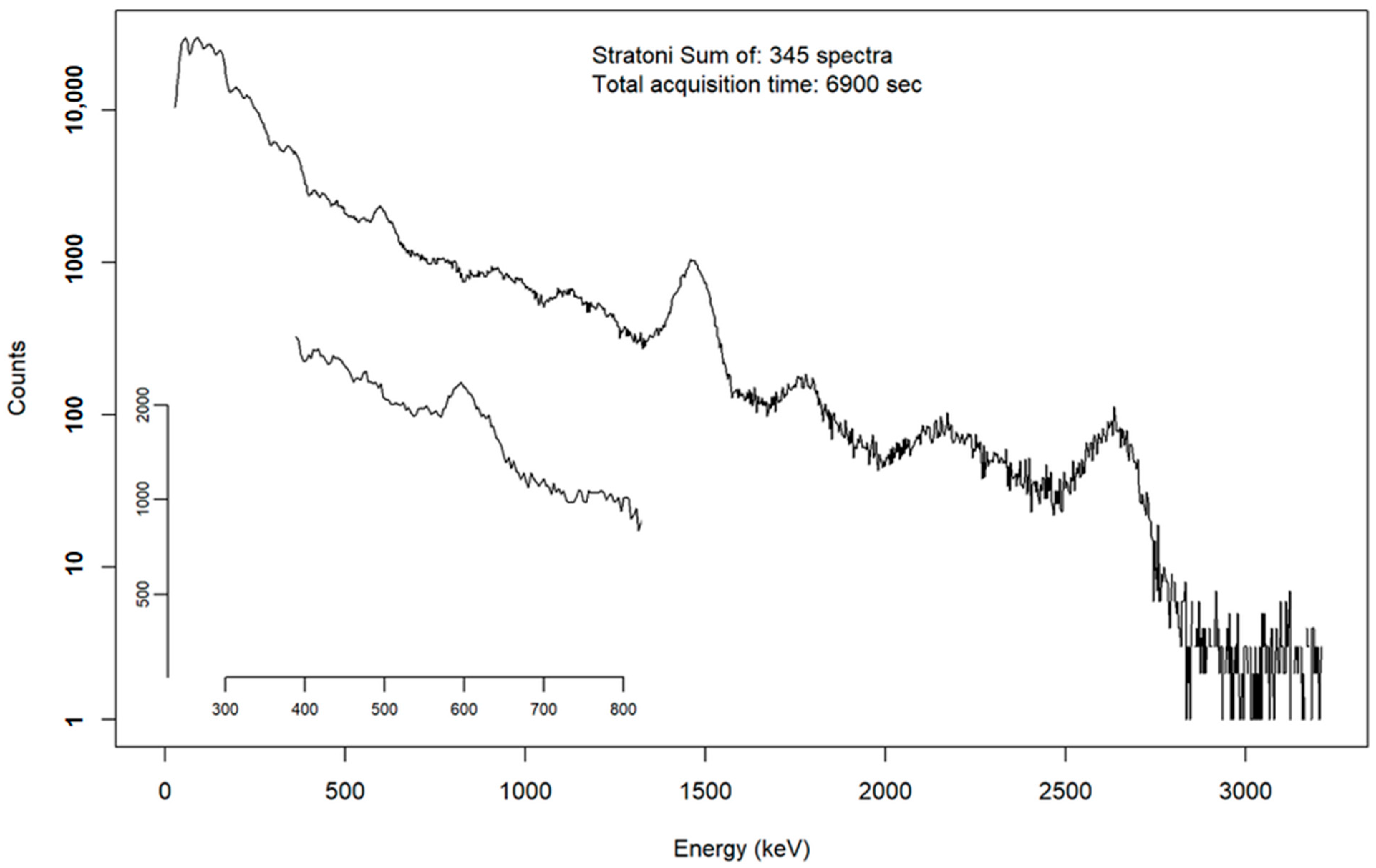
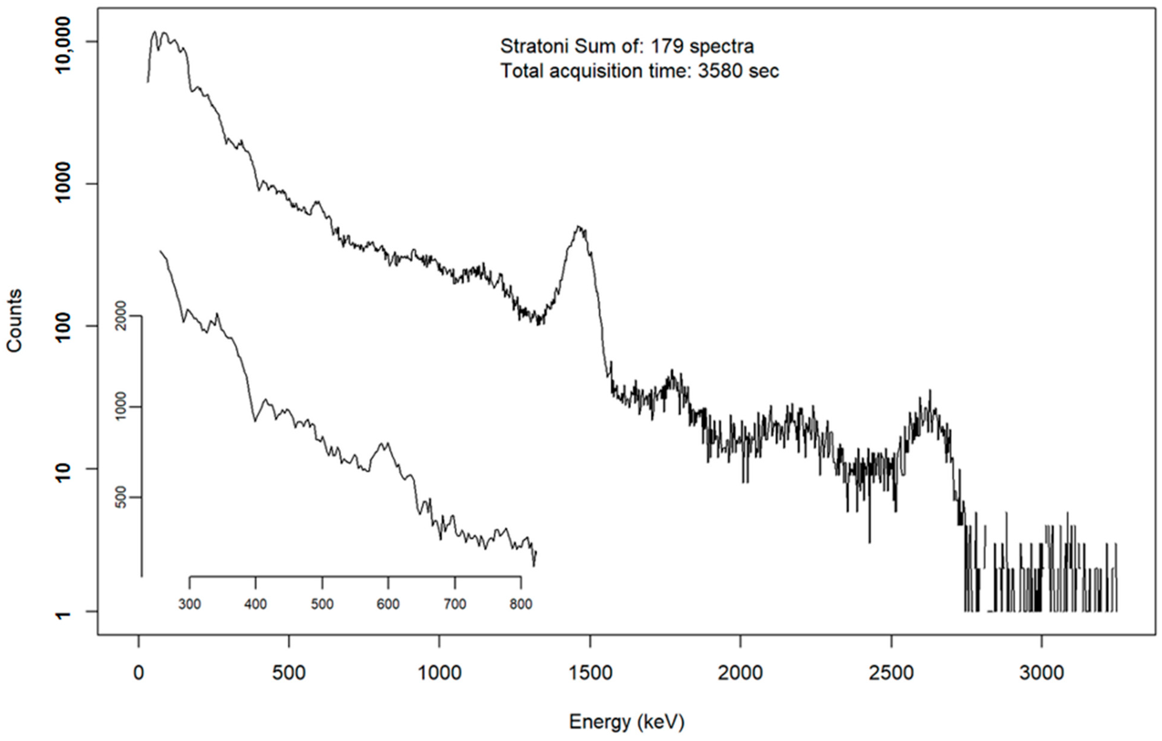
3.1. Stratoni Port
3.2. Ierissos Port
4. Discussion
4.1. Inter-Comparison of Measurement Methods
4.2. Radiological Assessment
4.3. Enrichment Factors
5. Summary
Author Contributions
Funding
Institutional Review Board Statement
Informed Consent Statement
Data Availability Statement
Acknowledgments
Conflicts of Interest
References
- Plant, J.A.; Saunders, A.D. The radioactive Earth. Radiat. Prot. Dosim. 1996, 68, 25–36. [Google Scholar] [CrossRef]
- UNSCEAR. Sources and Effects of Ionizing Radiation. In United Nations Scientific Committee on the Effects of Atomic Radiation Report to the General Assembly with Scientific Annexes Vol II: Effects; United Nations: New York, NY, USA, 2000. [Google Scholar]
- Lambrechts, A.; Foulquier, L.; Garnier-Laplace, J. Natural Radioactivity in the Aquatic Components of the Main French Rivers Get access Arrow. Radiat. Prot. Dosim. 1992, 45, 253–256. [Google Scholar] [CrossRef]
- Tsabaris, C. Changes of gross gamma-ray intensity in a submarine spring system due to a distant earthquake event on 30th of March 2019 at Itea, Greece. J. Radioanal. Nucl. Chem. 2021, 330, 755–763. [Google Scholar] [CrossRef]
- Yang, W.-F.; Chen, M.; Zhang, X.-X.; Guo, Z.-G.; Li, G.-X.; Ma, Q.; Yang, J.-H.; Huang, Y.-P. Thorium isotopes (228Th, 230Th, 232Th) and applications in reconstructing the Yangtze and Yellow River floods. Int. J. Sediment Res. 2013, 28, 588–595. [Google Scholar] [CrossRef]
- Jacques, B. The investigation of natural radionuclides as tracers for monitoring sediment processes. J. Appl. Geophys. 2020, 181, 104135. [Google Scholar] [CrossRef]
- Wang, J.; Zhang, W.; Baskaran, M.; Du, J.; Zhou, F.; Wu, H. Fingerprinting sediment transport in river-dominated margins using combined mineral magnetic and radionuclide methods. J. Geophys. Res. Ocean. 2018, 123, 5360–5374. [Google Scholar] [CrossRef]
- Thereska, J. Natural radioactivity of coastal sediments as tracer in dynamic sedimentology. Nukleonika 2009, 54, 45–50. [Google Scholar]
- Pappa, F.K.; Tsabaris, C.; Ioannidou, A.; Patiris, D.L.; Kaberi, H.; Pashalidis, I.; Eleftheriou, G.; Androulakaki, E.G.; Vlastou, R. Radioactivity and metal concentrations in marine sediments associated with mining activities in Ierissos Gulf, North Aegean Sea, Greece. Appl. Radiat. Isot. 2016, 116, 22–33. [Google Scholar] [CrossRef]
- Pappa, F.K.; Tsabaris, C.; Patiris, D.L.; Eleftheriou, G.; Ioannidou, A.; Androulakaki, E.G.; Kokkoris, M.; Vlastou, R. Temporal investigation of radionuclides and heavy metals in a coastal mining area at Ierissos Gulf, Greece. Environ. Sci. Pollut. Res. 2019, 26, 27457–27469. [Google Scholar] [CrossRef]
- Pappa, F.K.; Tsabaris, C.; Patiris, D.L.; Androulakaki, E.G.; Ioannidou, A.; Eleftheriou, G.; Kokkoris, M.; Vlastou, R. Dispersion pattern of 226Ra and 235U using the ERICA Tool in the coastal mining area, Ierissos Gulf, Greece. Appl. Radiat. Isot. 2019, 145, 198–204. [Google Scholar] [CrossRef] [PubMed]
- Vinković, A.; Laptyev, G.; Yaprak, G.; Slavova, K.; Joksimović, D.; Troskot-Čorbić, T.; Frontasyeva, M.; Duliu, O.G.; Bylyku, E.; Shyti, M.; et al. Could atmospheric carbon be driving sedimentation? J. Soils Sediments 2022, 22, 2912–2928. [Google Scholar] [CrossRef]
- Eisenbud, M. Environmental Radioactivity; Academic Press, Inc.: London, UK, 1987. [Google Scholar]
- Ritchie, J.-C.; McHenry, J.-R. Application of Radioactive Fallout Cesium-137 for Measuring Soil Erosion and Sediment Accumulation Rates and Patterns: A Review. J. Environ. Qual. 1990, 19, 215–233. [Google Scholar] [CrossRef]
- Yasunari, T.J.; Stohl, A.; Hayano, R.S.; Burkhart, J.F.; Eckhardt, S.; Yasunari, T. Cesium-137 Deposition and Contamination of Japanese Soils due to the Fukushima Nuclear Accident. Proc. Natl. Acad. Sci. USA 2011, 108, 19530–19534. [Google Scholar] [CrossRef]
- Kelepertzis, E. Heavy metals baseline concentrations in soft tissues of Patell sp. from the Stratoni coastal environment, NE Greece. Ecol. Chem. Eng. S 2013, 20, 141–149. [Google Scholar] [CrossRef]
- Tsabaris, C.; Bagatelas, C.; Dakladas, T.; Papadopoulos, C.T.; Vlastou, R.; Chronis, G.T. An autonomous in situ detection system for radioactivity measurements in the marine environment. Appl. Radiat. Isot. 2008, 66, 1419–1426. [Google Scholar] [CrossRef]
- Bagatelas, C.; Tsabaris, C.; Kokkoris, M.; Papadopoulos, C.T.; Vlastou, R. Determination of marine gamma activity and study of the minimum detectable activity (MDA) in 4pi geometry based on Monte Carlo simulation. Environ. Monit. Assess. 2010, 165, 159–168. [Google Scholar] [CrossRef]
- Tsabaris, C.; Scholten, J.; Karageorgis, A.P.; Comanducci, J.F.; Georgopoulos, D.; Liong Wee Kwong, L.; Patiris, D.L.; Papathanassiou, E. Underwater in situ measurements of radionuclides in selected submarine groundwater springs, Mediterranean sea. Radiat. Prot. Dosim. 2010, 142, 273–281. [Google Scholar] [CrossRef]
- Tsabaris, C.; Anagnostou, M.N.; Patiris, D.L.; Nystuen, J.A.; Eleftheriou, G.; Dakladas, T.; Papadopoulos, V.; Prospathopoulos, A.; Papadopoulos, A.; Anagnostou, E.N. A marine groundwater spring in Stoupa, Greece: Shallow water instrumentation comparing radon and ambient sound with discharge rate. Procedia Earth Planet. Sci. 2011, 4, 3–9. [Google Scholar] [CrossRef]
- Tsabaris, C.; Patiris, D.L.; Karageorgis, A.P.; Eleftheriou, G.; Papadopoulos, V.P.; Georgopoulos, D.; Papathanassiou, E.; Povinec, P.P. In-situ radionuclide characterization of a submarine groundwater discharge site at Kalogria Bay, Stoupa, Greece. J. Environ. Radioact. 2012, 108, 50–59. [Google Scholar] [CrossRef]
- Wedepohl, K. The composition of the continental crust. Geochim. Cosmochim. Acta 1995, 59, 1217–1232. [Google Scholar] [CrossRef]
- Tsabaris, C.; Eleftheriou, G.; Patiris, D.L.; Androulakaki, E.G.; Kapanadze, N.; Pappa, F.K.; Melikatze, G.; Ruzsa, G. Distribution of activity concentration and dose rates in selected coastal areas on western and eastern Black Sea. J. Radioanal. Nucl. Chem. 2019, 321, 169–181. [Google Scholar] [CrossRef]
- Patiris, D.L.; Tsabaris, C.; Alexakis, S.; Maramathas, C.; Androulakaki, E.; Eleftheriou, G.; Pappa, F. Rapid radiometric mapping of coastal areas by means of mobile in situ gamma-ray spectrometry. In Proceeding of the 6th International Conference on Environmental Radioactivity, ENVIRA 2021, Ioannina, Greece, 7–9 October 2021. [Google Scholar]
- R Core Team. R: A Language and Environment for Statistical Computing; R Foundation for Statistical Computing: Vienna, Austria, 2020; Available online: https://www.R-project.org/ (accessed on 1 January 2019).
- Helfer, I.K.; Miller, I.K. Calibration factor for field spectrometry. Health Phys. 1988, 55, 15–29. [Google Scholar] [CrossRef] [PubMed]
- Kalfas, C.A.; Axiotis, M.; Tsabaris, C. SPECTRW: A software package for nuclear and atomic spectroscopy. Nucl. Instrum. Methods Phys. Res. A 2016, 830, 265–274. [Google Scholar] [CrossRef]
- Tsabaris, C.; Patiris, D.L.; Maramathas, C.A.; Androulakaki, E.G.; Eleftheriou, G.; Pappa, F.K.; Alexakis, S. Surveillance of the seashore using the KATERINA II geo-referenced detection system. In Proceedings of the 30th Hellenic Symposium on Nuclear Physics and Applications, Ioannina, Greece, 7–8 October 2022. [Google Scholar]
- Karageorgis, A.; Katsanevakis, S.; Kaberi, H. Use of Enrichment Factors for the Assessment of Heavy Metal Contamination in the Sediments of Koumoundourou Lake, Greece. Water Air Soil Pollut. 2009, 204, 243–258. [Google Scholar] [CrossRef]
- Petrinec, B.; Franic’, Z.; Leder, N.; Tsabaris, C.; Bituh, T.; Marović, G. Gamma radiation and dose rate investigations on the Adriatic islands of magmatic origin. Radiat. Prot. Dosim. 2010, 139, 551–559. [Google Scholar] [CrossRef] [PubMed]
- Ababneh, Z.Q.; Al-Omari, H.; Rasheed, M.; Al-Najjar, T.; Ababneh, A.M. Assessment pf gamma-emitting radionuclides in sediment cores from the gulf of Aqaba, red Sea. Radiat. Prot. Dosim. 2010, 141, 289–298. [Google Scholar] [CrossRef]
- UNSCEAR. Sources and effects of ionizing radiation. United Nations Scientific Committee on the effects of Atomic Radiation. Sources and effects of ionizing radiation. In New York: Report to General Assembly with Scientific Annexes Vol I; United Nations: New York, NY, USA, 2000. [Google Scholar]
- Birch, G.F.; Davies, K.I. A scheme for assessing human impact and sediment quality in coastal waterways. In Proceedings of the Coastal GIS Conference, Wollongong, Australia, 7–8 July 2003; Wollongong Papers on Marine Policy, 14, Woodroffe, C.D., Furness, R.A., Eds.; University of Wollongong: Wollongong, NSW, Australia, 2003; pp. 371–380. [Google Scholar]


| Trace Metal Concentrations | Enrichment Factors | |||||||||
|---|---|---|---|---|---|---|---|---|---|---|
| Station | As | Cu | Pb | Zn | Mn | As | Cu | Pb | Zn | Mn |
| μg·g−1 | μg·g−1 | μg·g−1 | μg·g−1 | μg·g−1 | ||||||
| STR1_a | 1500 | 140 | 1200 | 3900 | 27,000 | 197 | 37 | 58 | 736 | 482 |
| STR1_b | 800 | 80 | 1100 | 2000 | 9200 | 79 | 17 | 41 | 282 | 127 |
| STR2_a | 530 | 110 | 600 | 1300 | 8000 | 53 | 23 | 22 | 187 | 112 |
| STR2_b | 570 | 120 | 830 | 1900 | 17,000 | 63 | 27 | 33 | 308 | 266 |
| STR2_b2 | 4300 | 300 | 1750 | 3800 | 8000 | 750 | 109 | 112 | 987 | 206 |
| STR10_1a | 200 | 30 | 400 | 570 | 3500 | 22 | 6 | 14 | 83 | 48 |
| STR10_1b | 300 | 50 | 650 | 890 | 5800 | 29 | 9 | 22 | 120 | 75 |
| STR10_1b2 | 980 | 90 | 2600 | 1100 | 19,000 | 106 | 21 | 102 | 182 | 293 |
| STR10_2a | 260 | 80 | 510 | 950 | 3800 | 19 | 12 | 14 | 103 | 39 |
| STR10_2b | 300 | 130 | 500 | 420 | 2700 | 16 | 15 | 10 | 33 | 20 |
| STR13_a | 100 | 20 | 250 | 270 | 740 | 15 | 4 | 13 | 54 | 14 |
| STR13_b | 140 | 20 | 280 | 340 | 900 | 18 | 5 | 13 | 63 | 16 |
| STR11_0a | 8 | 7 | 40 | 6 | 180 | 1 | 1 | 1 | 1 | 2 |
| STR11_0b | 8 | 4 | 30 | 4 | 60 | 1 | 1 | 1 | 0.4 | 1 |
| STR11_1a | 18 | 10 | 50 | 100 | 330 | 1 | 2 | 1 | 10 | 3 |
| STR11_1b | 780 | 90 | 1100 | 1800 | 9000 | 78 | 19 | 40 | 257 | 124 |
| STR11_2a | 10 | 9 | 40 | 10 | 100 | 1 | 1 | 1 | 1 | 1 |
| STR11_2b | 9 | 4 | 40 | 8 | 140 | 1 | 1 | 1 | 1 | 1 |
| STR12_b | 12 | 6 | 30 | 8 | 90 | 1 | 1 | 1 | 1 | 1 |
| In Situ | Laboratory | ||||
|---|---|---|---|---|---|
| Isotope | Stratoni | Ierissos | Stratoni | Ierissos | Rivers |
| 40K | 425 ± 34 | 417 ± 33 | 580 ± 60 | 950 ± 95 | (320–1100) ± 100 |
| 214Bi | 33 ± 4 | 12.3 ± 1.5 | 50 ± 4 | 9.3 ± 0.9 | (8–60) ± 3 |
| 208Tl | 19 ± 2 | 10.0 ± 1.2 | 25 ± 2 | 12.2 ± 1.1 | (11–30) ± 4 |
| 137Cs | 6.9 ± 1.1 | 3.8 ± 0.5 | 0.8 ± 0.2 | 0.8 ± 0.2 | (0.7–20) ± 0.2 |
Disclaimer/Publisher’s Note: The statements, opinions and data contained in all publications are solely those of the individual author(s) and contributor(s) and not of MDPI and/or the editor(s). MDPI and/or the editor(s) disclaim responsibility for any injury to people or property resulting from any ideas, methods, instructions or products referred to in the content. |
© 2023 by the authors. Licensee MDPI, Basel, Switzerland. This article is an open access article distributed under the terms and conditions of the Creative Commons Attribution (CC BY) license (https://creativecommons.org/licenses/by/4.0/).
Share and Cite
Tsabaris, C.; Patiris, D.L.; Adams, R.; Castillo, J.; Henriquez, M.F.; Hurtado, C.; Munoz, L.; Kalpaxis, L.; Verri, M.; Alexakis, S.; et al. In Situ Radioactivity Maps and Trace Metal Concentrations in Beach Sands of a Mining Coastal Area at North Aegean, Greece. J. Mar. Sci. Eng. 2023, 11, 1207. https://doi.org/10.3390/jmse11061207
Tsabaris C, Patiris DL, Adams R, Castillo J, Henriquez MF, Hurtado C, Munoz L, Kalpaxis L, Verri M, Alexakis S, et al. In Situ Radioactivity Maps and Trace Metal Concentrations in Beach Sands of a Mining Coastal Area at North Aegean, Greece. Journal of Marine Science and Engineering. 2023; 11(6):1207. https://doi.org/10.3390/jmse11061207
Chicago/Turabian StyleTsabaris, Christos, Dionisis L. Patiris, Rosalinda Adams, Julian Castillo, Maria F. Henriquez, Caroline Hurtado, Lesley Munoz, Leonidas Kalpaxis, Mariana Verri, Stylianos Alexakis, and et al. 2023. "In Situ Radioactivity Maps and Trace Metal Concentrations in Beach Sands of a Mining Coastal Area at North Aegean, Greece" Journal of Marine Science and Engineering 11, no. 6: 1207. https://doi.org/10.3390/jmse11061207
APA StyleTsabaris, C., Patiris, D. L., Adams, R., Castillo, J., Henriquez, M. F., Hurtado, C., Munoz, L., Kalpaxis, L., Verri, M., Alexakis, S., Pappa, F. K., & Lampousis, A. (2023). In Situ Radioactivity Maps and Trace Metal Concentrations in Beach Sands of a Mining Coastal Area at North Aegean, Greece. Journal of Marine Science and Engineering, 11(6), 1207. https://doi.org/10.3390/jmse11061207