Article

Tectonic Transformation, Magmatic Activity and Subsidence Centre Migration of Eocene Half-Grabens: A Case Study of the Northern Pearl River Mouth Basin (PRMB) in the Northern South China Sea

1
Shenzhen Branch of CNOOC, Ltd., Shenzhen 518000, China
2
College of Earth Sciences, Jilin University, Changchun 130061, China
*
Author to whom correspondence should be addressed.
J. Mar. Sci. Eng. 2023, 11(3), 579; https://doi.org/10.3390/jmse11030579
Submission received: 18 December 2022 / Revised: 26 February 2023 / Accepted: 26 February 2023 / Published: 8 March 2023
(This article belongs to the Section Geological Oceanography)

Abstract

:
The Pearl River Mouth Basin (PRMB) is located in the northern part of the South China Sea. The Palaeogene Wenchang Formation (Fm) was formed at the rift stage and contains the main source rocks. The migration of Wenchang subsidence centres in the western Zhu I Depression and northern Yangjiang-Yitong Fault Zone are controlled by tectonic transformation and partially influenced by magmatic activity. From the Eocene Wenchang (E2WC) to the Eocene and Oligocene Enping (E2+3EP) stages, the regional extension direction rotated clockwise from NW–SE to S–N, and the strike of the regional strike-slip fault was NW–SE. The subsidence centres of the Wenchang Fm in the western subsags of the Zhu I Depression migrated to the Beiweitan Fault in a convergent way. Magmatic activity at the E2WC stage developed mostly along the central edge of the subsags. Local subsidence migrated to the side of the basin-controlling faults. The migration characteristics of the subsidence centre of the Wenchang Fm in each subsag are complex in the northern Yangjiang-Yitong Fault Zone. There was no magmatic activity at the E2WC to E2+3EP stage of the Enping 27 subsag, and the subsidence centre migrated eastwards, which is basically consistent with the migration pattern of the Enping sag. In the eastern Yangjiang sag, the strike of the subsags was ENE. The angle between the extensional direction and subsag strike at the E2WC to E2+3EP stage first increased and then decreased. Magmatic activity at the E2WC stage mostly developed in the subsags. Tectonic transformation and magmatic activity at the E2WC stage led to subsidence centre migration from the Enping 21 subsag to the Enping 20 subsag northwest. From the end of the E2WC stage to the E2+3EP stage, magmatic activity developed at the subsag margins, which resulted in severe denudation. Research on the entire area indicates that tectonic transformation controls subsidence centre migration. Magmatic activity influences the migration of subsidence centres locally or controls this process through tectonic transformation.

1. Introduction

The structural transfer zone was first proposed in the study of compressional thrust structures, which refers to a structural belt with conserved strain and displacement between two lateral faults, including folds, faults, and complex combinations of these structures [1]. Afterwards, the structural transfer zone was introduced into the study of extensional faulted basins [2,3,4], which refers to faulted depressions or faulted groups controlled by head–tail normal faults or normal fault groups connected by an intracontinental transition layer [5]. Structural transformation has a broader meaning, which refers to tectonism migration, transformation, and attribute change in space over time, including fault activity, rift structure formation, uplift and subsidence, sedimentary filling migration, and magmatic activity [6,7]. Regular changes in the direction and intensity of the regional tectonic stress can lead to changes in the fault occurrence and activity intensity [8]. This conversion can cause subsidence centre migration along or at an angle with the basin-controlling faults [9,10], which can also be accompanied by regular magmatic activity.
The distribution of magmatic activity is related to the distribution of faults [11,12,13]. At the same time, magmatic activity influences the occurrence of faults, and structural transformation of half-graben faults and magmatic activity are interaction processes [12]. Simulation experiments and geological studies showed that the lower crust pressure decreases and a ductile dome can occur when a rift basin develops in the upper crust, and the magmatic activity is distributed along the vertical extension direction [12,14]. When the angle between the extension direction and the strike of the fault basin is greater than or equal to 45°, magma and the lower crust intrude into the edge of the basin along the footwall of the basin-controlling boundary fault, parallel to the strike of the fault zone. Magma invasion also causes the fault to rotate, the dip angle increases, and the subsidence centre migrates away from the basin-controlling fault [15]. When the angle between the extension direction and the strike of the fault basin is less than or equal to 35°, magma and the lower crust intrude into the centre of the basin in the lower part, and echelon oblique-slip faults are developed in the basin. Magma develops in the structural transformation part, and magma intrusion further leads to fault rotation and a decrease in the dip angle. The subsidence centre migrates towards the direction of the basin-controlling fault [16,17]. The influence of early magmatic activity on fault development is controversial [18]. The interaction between faults and magmatic activity is confirmed by the study of ancient rift evolution and modern rifting [19,20]. When the extension direction changes and multistage tectonic movement occurs, structural transformation and multistage magmatic emplacement superimposition can ensue, resulting in a more complex rift structure [21,22].
The northern part of the South China Sea was an extensional continental margin during the Cenozoic. The rift lake basin was developed during the deposition of the Eocene Wenchang and Enping Formations (Fms) in the Pearl River Mouth Basin (PRMB). The Huizhou movement after the early E2WC stage and the Zhuqiong II movement after the late E2WC stage led to regional tectonic transformation [7,23,24]. The Wenchang Fm is the main horizon of source rocks, and two-stage tectonic transformation imposes an important influence on the formation and reformation of the Wenchang Fm. Previous researchers studied the source-to-sink system development model and its temporal–spatial variation in the Wenchang Fm under the influence of tectonic transformation in the Zhu I Depression. Much progress was achieved in regard to research on the Lufeng, Huizhou, and Enping sags and the Eastern Yangjiang Sag adjacent to the Zhu I Depression [25,26,27,28]. The influence of magmatic activity on tectonic evolution was studied in the Baiyun Sag of the Zhu II Depression and the Huizhou and Lufeng Depressions of the Zhu I Depression in the south. The bedrock crust was subjected to magmatic intrusion, which led to the rotation and tilting of the rifted basin; moreover, the occurrence of boundary faults gradually decreases, the gentle slope of the rifted basin is tilted and eroded, the high temperature also causes the crust to become ductile, and the extension and detachment along the boundary faults are further strengthened [14,15]. There is a lack of understanding of the tectonic transformation and magmatic activity in the western part of the Zhu I Depression. Recent seismic and geological studies found that the magmatic activity at the rift stage in the northern part of the PRMB exhibits a certain regularity. In this paper, the structural transformation and magmatic activity during the rift stage period and their influences on the migration of the subsidence centre were studied in the Xijiang and Enping sags in the western part of the Zhu I Depression and the Eastern Yangjiang Sag in the Zhu III Depression. This is very important for subsequent sedimentary research and oil and gas exploration of the Wenchang Fm.

2. Geological Setting

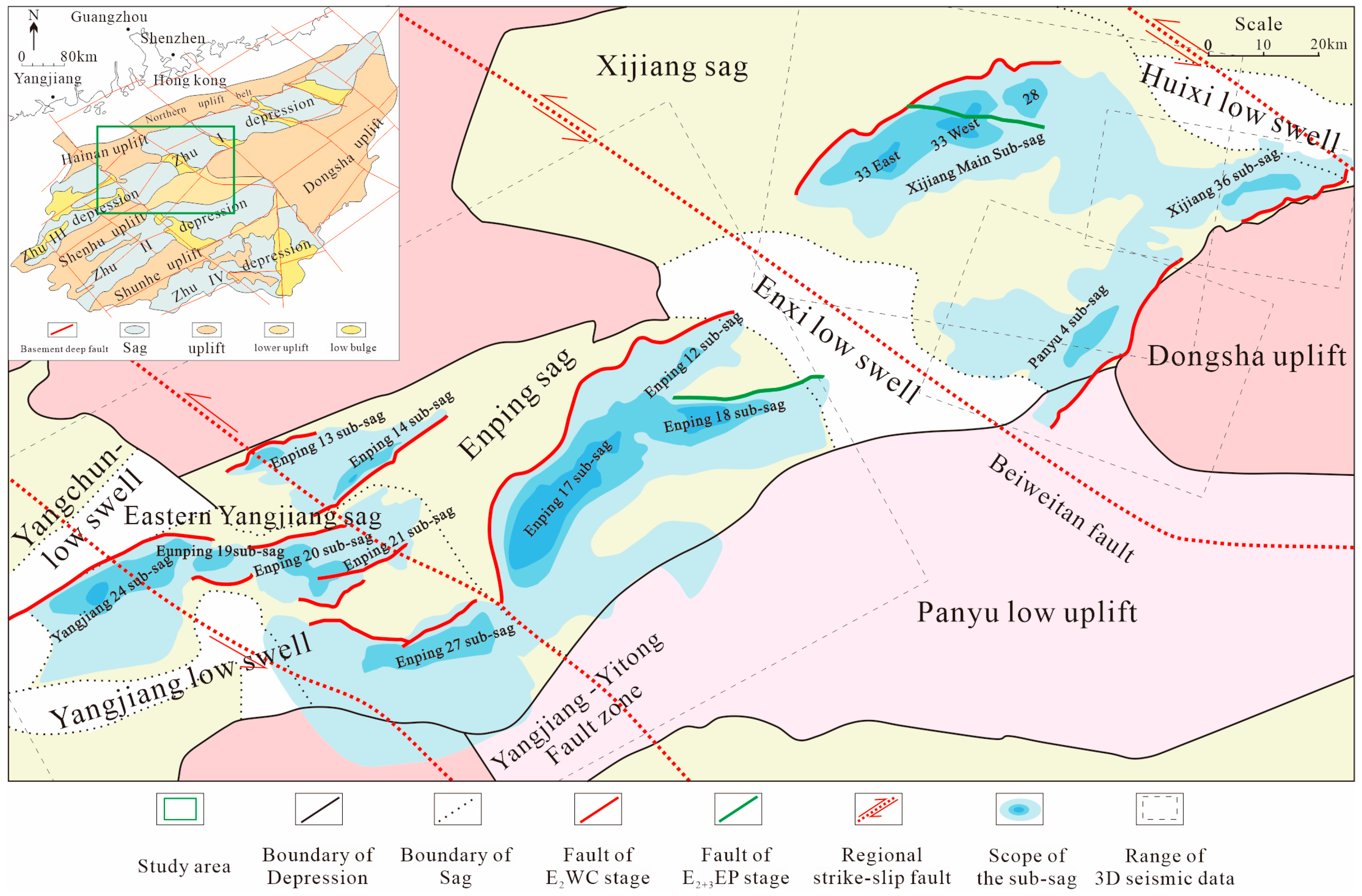
The PRMB is located in the northern part of the South China Sea and is a Cenozoic petroliferous basin developed on the Palaeozoic and Mesozoic complex fold basement. The regional tectonics of the PRMB are complex and are associated with a passive margin developed from a Mesozoic active continental margin against the background of the relative convergence rate of the Pacific plate, the Indian Ocean plate, and the Eurasian plate [29]. The tectonic framework of the basin formed in the palaeotectonic stress field whose transformation against the background of multiplate convergence. The tectonic framework dominated by the NE–NEE fault system and jointly controlled by the NW–NWW fault system [30], in which graben basin formed in Paleogene, depressed basin formed in Neogene. The secondary structures in PRMB has a banding distribution along the north-southwest direction, a clustered distribution along the east-west direction (Figure 1). The tectonic evolution of the basin has episodic characteristics [31]. The Shenhu Movement, the first episode of the Zhuqiong Movement, and the second episode of the Zhuqiong Movement occurred at the rift stage, and the continental Palaeocene Shenhu Formation, the Eocene Wenchang Fm, and the Enping Formation were developed [32]. The South China Sea Movement, the Baiyun Movement and the Dongsha Movement occurred during the depression period, and the marine Oligocene Zhuhai Formation, the Miocene Zhujiang Formation, the Hanjiang Formation, the Yuehai Formation, the Pliocene Wanshan Formation, and Quaternary Holocene strata were developed (Figure 2).
The lithospheric structural unit of the passive continental margin in the northern South China Sea can be divided into four tectonic units from land to sea: proximal zone, thin-necked zone, distal zone, and ocean–continent transition zone [33]. Magma played a decisive role in the process of tension and rupture of the passive continental margin, and a large amount of magmatic activity occurred at the continental margin of the South China Sea [34]. The Zhu I Depression is located in the proximal zone and features several rift basins controlled by low-angle detachment faults in the upper crust. The formation of these detachment faults is usually controlled by magmatic emplacement and (or) preexisting faults; notably, the deposition of the Wenchang Fm is controlled by both faults and magmatic activity [15]. The sags in the Zhu I Depression are rhombic, including the Hanjiang, Lufeng, Huizhou, Xijiang, and Enping sags from east to west. The western part of the Zhu I Depression is connected with the eastern Yangjiang Sag of the Zhu Ⅲ Depression. The Wenchang Fm in the Zhu I Depression can be divided into six members. T83 is the time interface between the early and late E2WC stages east of the Yangjiang-Yitong Fault Zone, namely, the Zhu I Depression. The Wenchang Fm to the west of or in the Yangjiang-Yitong Fault Zone was divided into three members by time interfaces T82 and T81. The time interface concept was just unified recently, and the former T83 corresponds to the latter T81 [35]. The Huizhou and Lufeng Sag deposits occur in the lower Wenchang Fm and Enping Formation, and magmatic activity mostly occurred at the late early E2WC stage. In the study area, the lower and upper Wenchang Fms in the Xijiang, Enping, and eastern Yangjiang sags are consistently distributed.
Figure 1. Structural location and sag distribution map of the study area. Adapted from [31,35].
Jmse 11 00579 g001
Figure 2. Comprehensive histogram of the stratigraphic-structural evolution in the study area, adapted from [32].
Jmse 11 00579 g002

3. Data and Methods

In the northern PRMB, the depth of Palaeogene strata is generally more than 3000 m. Past seismic data of deep strata exhibit a low signal-to-noise ratio, low effective energy, and notable background noise. These data mask many reflection details. The latest seismic data were used in this study. All these 3D seismic data, well data, as well as the samples, were collected by the China National Offshore Oil Corporation (CNOOC) Shenzhen Branch. The 3D seismic dataset has a bin spacing of 12.5 m in both the inline and the crossline directions. These seismic volumes have sample rates of 2 ms, and a dominant frequency of 30 Hz in average, which gives a vertical resolution of approximately 20 m. The large amounts of seismic data with high resolution ensure that we can accurately analyze the time interface in the seismic profiles and the spatial range of the magmatism. Four seismic data bodies were considered that encompassed all subsags in the study area, covering approximately 1.6 × 10⁴ km2. The strata and faults were explained via the main survey line and the contact line, with a minimum interval of 50 m. More than seven seismic horizons were interpreted, each of which has a corresponding time. These seismic horizons could be used to estimate the approximate age of migmatic activity. Only seven wells were drilled into magmatic rocks, and their extent was delineated based on seismic facies near the wells and studies of other basins. At the location where magmatic rocks were not revealed by drilling, the location and range of magmatic activity were predicted according to seismic reflection characteristics, including clusters of abnormally intense reflection in the basement, veined reflection that intersects the strata, convex reflection structure in the discontinuous overlying strata, and radial fault, as well as previous research results obtained via element analysis.
In the rift basin, total subsidence of each stage equals to the sum of straum thickness, paleo-water depth, and the value of eustatic sea-level change. In this study, after time–depth conversion, a stratigraphic thickness map was obtained to describe the migration of the subsidence centre. The specific subsidence amount was not calculated in this study because very few wells were drilled in the Wenchang Fm, and the revealed thickness was not large, so specific parameters, such as the palaeo-water depth, compaction rate, and value of lake level change, could not be calculated accurately, which are necessary to calculate the subsidence amount. Although the denudation of the Wenchang Fm is intense in some areas, this process did not affect the pattern of the formation distribution, and most subsidence centres did not experience denudation. Therefore, it is reasonable to analyse subsidence centre migration by using the thicknesses of the upper and lower Wenchang Fms in this study.

4. Results

4.1. Magmatic Activity and Tectonic Transformation

4.1.1. Identification of the Magmatic Rock Mass

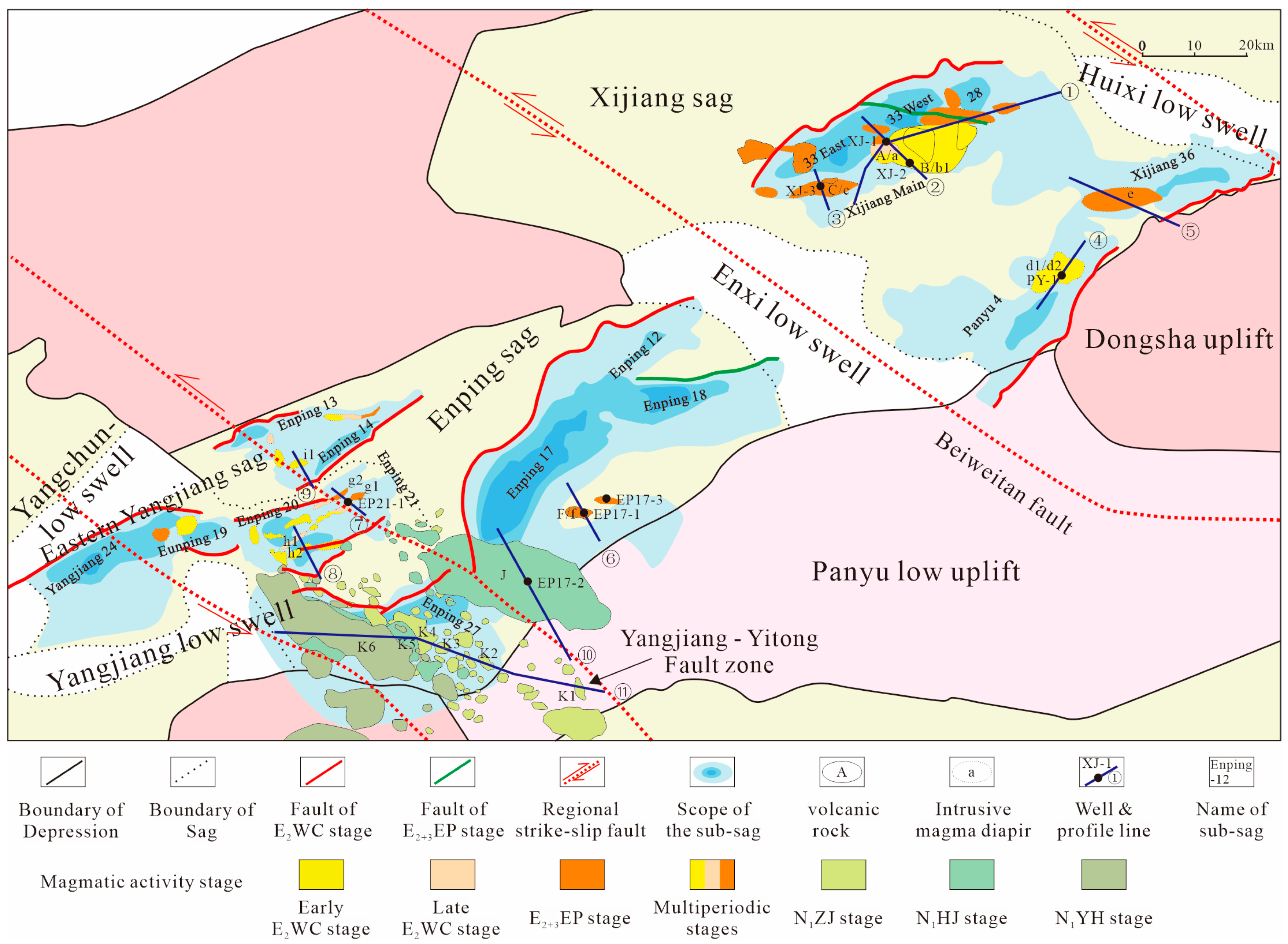
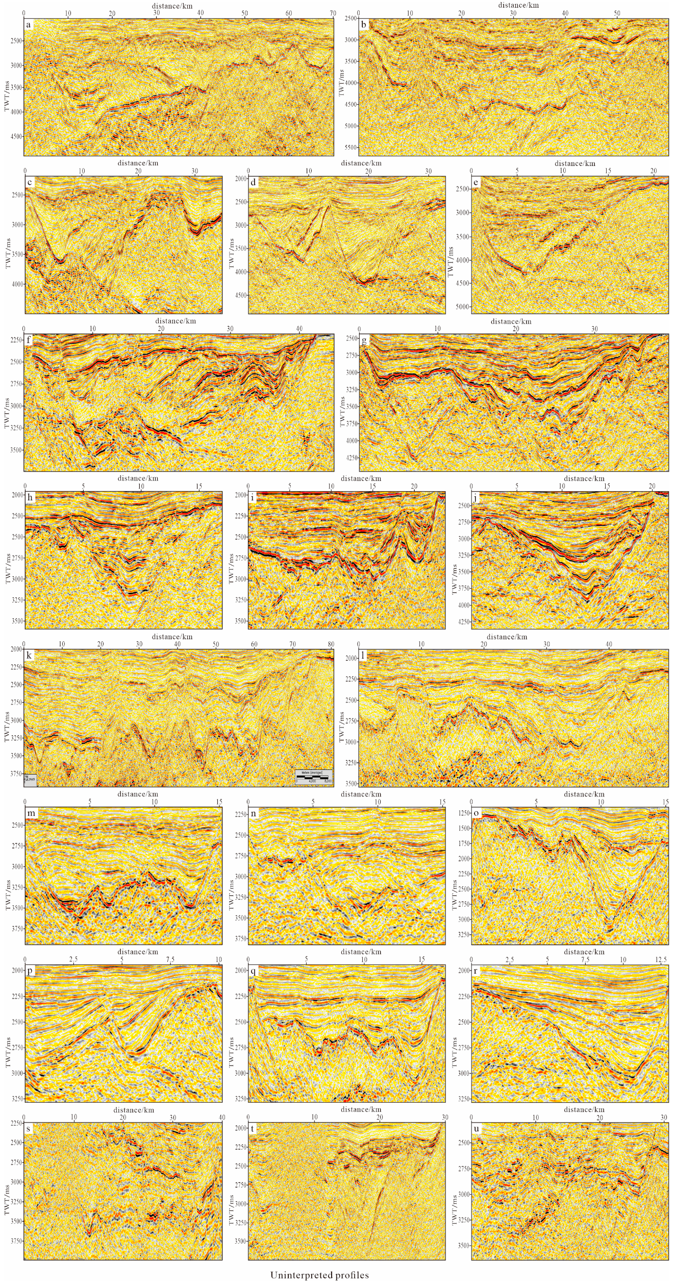
Only seven wells of Mesozoic–Cenozoic magmatic rocks were found in the study area. To reveal the regularity of magmatic activity, we predicted the distribution and activity period of magmatic rocks via seismic reflection characteristics (Table 1). The rocks revealed through drilling are all volcanic rocks. There occurred developed layered tuffaceous rocks with a medium-high frequency, medium-strong amplitude, moderate continuity, and disorderly reflection, approximately circular or oval in the plane (Figure 3①A,②A). There were also plate- and shield-like intermediate–basic lavas with a medium-high frequency, large amplitude, suitable continuity, and parallel subparallel reflections (Figure 3②B,③C,⑥F,⑩J), which are approximately circular and oval in the plane. Combined with previous experience of basin volcanic rock prediction [36] and the abovementioned method, volcanic rocks not revealed by drilling could be predicted (Figure 3⑪K1–6). In the interior of the basement beneath the volcanic rocks in the basin, there often occur anomalous geological bodies with irregular large amplitudes relative to the surrounding bodies, indicating the presence of hypabyssal intrusive bodies [37]. The structure is characterized by magmatic diapirs and mostly convex reflections (Figure 3①a,②b1,③c,④d,⑥f) and locally manifested as tongue-shaped or tabular-shaped rock beds (Figure 3②b2).

4.1.2. Magmatic Activity Time Analysis

The sedimentary period of the horizon where the volcanic distribution is located can indicate the time of magmatic activity. Magmatic diapirs can lead to changes in the thickness of the upper strata and the formation of faults. Based on these considerations, magmatic diapirs can be identified, and the time of magmatic activity can be assessed (Table 2). When a magma diapir occurs simultaneously with sedimentary filling, the upper strata are thinly or partially undeposited. When the magma diapir is developed after sedimentary filling and does not penetrate the stratum, the diapir does not affect the thickness variation in the upper stratum. When magmatic activity occurs after stratum deposition, the magma diapir penetrates the stratum, the diapir will not affect the overall variation in the thickness of the lower strata, and traction will occur around the rock mass. There are obvious truncations under the XJ-1 well in the lower Wenchang Fm and the upper part of the upper Wenchang Fm in the main subsag of Xijiang, and the thickness of the strata on both sides of the bulge changes significantly (Figure 3①,②). The XJ-1 well reveals tuff of the Enping Formation, and the upper part of the bulge features A-shaped faults. Therefore, there may be three stages of magmatic activity in this part: the end of the early E2WC stage, the end of the late E2WC stage, and the E2+3EP stage. The XJ-2 well reveals basalt in the lower part of the upper Wenchang Fm, indicating early magmatic activity at late Wenchang stage. The Panyu 4 subsag reveals hypabyssal intrusive diabase, which is obviously truncated in the upper part of the Wenchang Fm, indicating magmatic activity at the end of the early E2WC stage [38]. To the west of the Xijiang 36 subsag, the E2+3EP stage and its subsequent active faults transect the Wenchang Fm, and the thickness of the Enping Fm is discontinuous, indicative of the magmatic activity at the E2+3EP stage. Well EP17-1 in the Enping Sag reveals basalt of the Enping Formation, indicating magmatic activity during the E2+3EP stage. Although there is no magmatic rock drilled in the Enping 20/21 subsag of Eastern Yangjiang sag, elemental analysis of well EP21-1 indicated the occurrence of magmatic hydrothermal activity during the E2WC stage [39] (Figure 3⑦). At the same time, there are also obvious sharp angular bulges in the basement, significantly changing the thickness of the Enping Formation on both sides (Figure 3⑧). Magmatic activity occurred at the end of the early E2WC stage, late E2WC stage, and E2+3EP stage. In contrast to the Xijiang main subsag, the eastern sag of Yangjiang did not reveal volcanic rocks of the Enping Fm. The upper part of the uplift showed continuous truncation from the end of the late E2WC stage to the E2+3EP stage, which is the last magmatic activity. The volcanic rocks from the west of the Enping 17 subsag to the Enping 27 subsag are widely distributed and are mainly the result of the magmatic activity at the Miocene Zhujiang (N1ZJ), Hanjiang (N1HJ), and Yuehai (N1YH) stages.

4.1.3. Distribution Characteristics of Magmatic Activity and Tectonic Transformation

At the beginning of the early E2WC stage, the regional stress field followed the NW–SE direction and began to rotate clockwise. It rotated along the NNW–SSE direction during the early and late E2WC, rotated along the SN direction, and was stretched at the E2+3EP stage [40]. With the change in the extension direction, the fault activity changed, or new faults formed. This structural transformation is related to the spatial and temporal distributions of magmatic rocks. The distribution of basin-controlling faults at the E2WC stage and E2+3EP stage are related to preexisting basement faults. The Xijiang main subsag, Panyu 4 subsag, and Xijiang 36 subsag in the Xijiang Sag are locally connected and developed independently at the E2WC stage. The Enping 17 subsag, Enping 12 subsag, and Enping 18 subsag in the Enping Sag are similar. The Xijiang Sag and Enping Sag at the E2+3EP stage developed into a unified basin with a strike of NE or NEE. The angle between the axis of the basin and the regional extension direction decreased, but it was always larger than 45°. Magmatic activity at the end of the early E2WC stage and the beginning of the late E2WC stage was located at the edge of the half-graben fault basin, such as the Xijiang main subsag. Magmatic activity was mainly found at the edge of the gentle slope. The faults at the E2WC stage were all medium- to low-angle normal faults. Magmatic activity was not found at the edge of the steep slope zone, which might be denuded or may exhibit chaotic seismic reflections in the basement. At the E2+3EP stage, a wide basin was formed, and the angle between the basin trend and the extension direction was still greater than 45°. Magmatic activity still occurred at the edge of the basin, but the angle decreased. Magma intruded into the basin in the lower part of the steep slope, penetrated the Wenchang Fm, or changed its shape. The dip angle of the basin-controlling fault was higher than that at the E2WC stage, and there was also magmatic activity outside. At the E2+3EP stage, the regional extension direction changed to SN, forming a series of EW-trending faults, and magmatic rocks were mostly distributed along the EW direction. Tectonic transformation was mainly manifested as a change in faults, and magmatic activity was an accompanying phenomenon. For example, the Enping 12 and 18 subsags were unified basins at the E2WC stage. EW-trending faults were formed at the middle of the E2+3EP stage, which separated the two sags. The seismic reflection could not illustrate the accompanying magmatic activity. At the E2WC stage, the trend of the basin-controlling faults in the Enping 13 and 14 subsags was NE, and the inclinations were opposite. The angle between the regional extension direction and the basin trend at the E2WC stage and E2+3EP stage gradually decreased. The overlapping part of the two subsags was also the gentle slope zone of the two basins, and magmatic activity developed at the end of the late E2WC stage. The gentle slope zone northwest of the Enping 14 subsag also produced magmatic activity at the end of the early E2WC stage.
The Enping 20, Enping 21, and Enping 27 subsags of the eastern Yangjiang Sag are located north of the Yangjiang-Yitong Fault Zone. The trend of the basin-controlling faults at the E2WC stage is nearly NE or NEE. The basin-controlling fault boundary of the Enping 20 and 21 subsags at the E2WC stage was ENE- and nearly E-W-trending, and the overlapping part of the basin was relatively large. The regional extension direction changed from NW–SE to S–N at the E2WC-E2+3EP stage. The strike of the basin-controlling fault was approximately 20° at the early E2WC stage, and the strike of the basin-controlling fault was approximately 10°. The angle between the regional extension direction and the axis of the basin changed from approximately 67.5° to 90°. Similar to the other subsags in the study area, the angle was greater than 45°, but the difference entailed that the angle of this subsag gradually increased. The pattern of magmatic activity was also the opposite. Magmatic activity started from the basin-controlling faults at the end of the early E2WC stage and ceased at the junction of the two subsags at the end of the late E2 WC stage. The magmatic activity in the northern gentle slope zone of the Enping 21 subsag continued to the E2+3EP stage. The tectonic transformation zone between the Enping 20 and 21 subsags and the Enping 19 subsag also exhibited magmatic activity at the E2+3EP stage. Volcanic eruptions at the N1ZJ, N1HJ, and N1YH stages developed from west to the east in the Enping 27 subsag and its periphery, and the eruption at the N1HJ stage was the most intensive. The Wenchang and Enping formations in the lower part of the Enping 27 subsag yielded seismic data of a poor quality and were disturbed by late volcanic eruptions, so the magmatic activity at the E2WC and E2+3EP stages could not be identified.

4.1.4. Regional Magmatic Activity Pattern

The Lower Wenchang Fm and Enping Fm are mainly developed in the Lufeng and Huizhou sags of the Zhu I Depression [41], and magmatic activity developed at the early E2WC stage [42]. In the Xijiang sag, magmatic activity developed at the end of the early E2WC stage, the beginning of the late E2WC stage, and the E2+3EP stage. The magmatic activity at the E2+3EP stage was more extensive. In the Enping sag, magmatic activity developed at the E2+3EP stage. In the eastern Yangjiang sag, the Enping 13 and 14 subsags developed at the early E2WC stage, the end of the early E2WC stage, the end of the late E2WC stage, and the E2+3EP stage. In the Enping 27 subsag and its periphery, magmatic activity developed at the N1ZJ, N1HJ, and N1YH stages. In summary, the magmatic activity at the E2WC stage was limited, the magmatic activity at the E2+3EP stage was extensive and intense, and the magmatic activity at the N1ZJ, N1HJ, and N1YH stages was intense but limited. The characteristics can be summarized as follows: from the Zhu I Depression to the Eastern Yangjiang sag, magmatic activity developed early in the east and late in the west. The magmatic activity in the Xijiang and Enping Sags mainly occurred at the rift stage. The magmatic activity in the Yangjiang-Yitong Fault Zone is complex, and there occurred magmatic activity from the rift stage to the depression stage (Figure 4).

4.2. Migration of the Subsidence Centre Controlled by Tectonic Transformation and Magmatic Activity

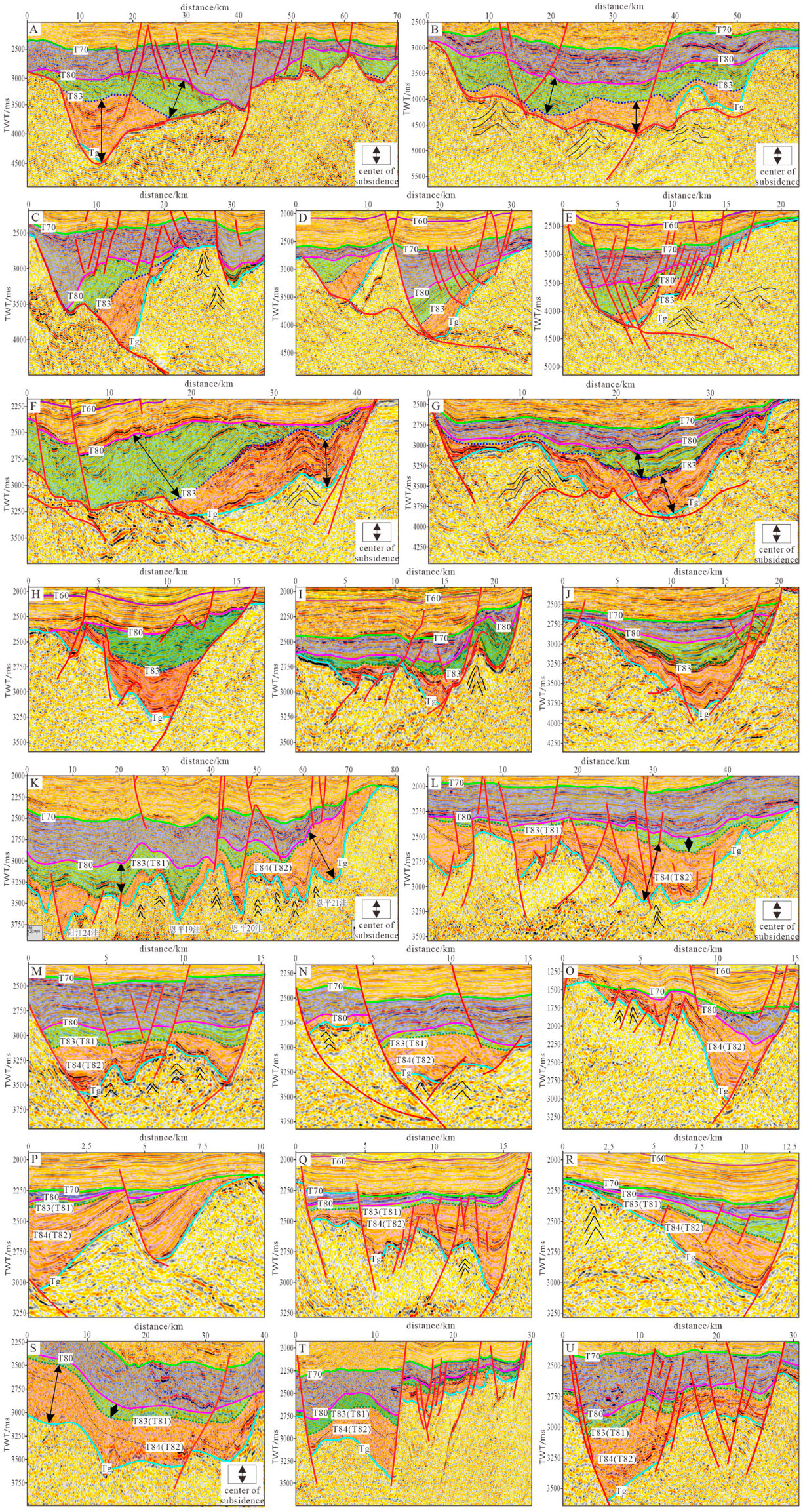
Through the analysis of the depression structure of the Wenchang Fm, it was found that the sags in the Xijiang Sag and Enping Sag in the eastern Yangjiang-Yitong Fault Zone are simple compound half-grabens, which are characterized by continuous control of the basin by a single fault. The subsidence centre of the Wenchang Fm migrated along the basin-controlling fault as a whole. Each subsag of the Yangjiang-Yitong Fault Zone is a complex compound half-graben, which is characterized by alternative basin-controlling faults distributed along opposite directions, and the subsidence centre during E2WC stage shows oblique migration (Figure 5 and Figure 6).

4.2.1. Axial Migration of Simple Compound Half-Grabens

The subsags in the Xijiang Sag and Enping Sag are characterized by simple compound half-grabens at the E2WC stage and E2+3EP stage. Regional tectonic transformation led to the migration of the subsidence centre along the basin-controlling fault as a whole, and the magmatic activity at the E2WC stage led to the migration of the local subsidence centre to the basin-controlling fault (Figure 5B). At the E2WC stage, the basin-controlling fault of the Xijiang main subsag trended NEE, and denudation only occurred at the edge of the gentle slope zone after the early E2WC stage and late E2WC stage. The dip angles of the eastern and western basin-controlling faults are similar. The fault displacement of the lower Wenchang Fm in the eastern part is greater than that in the western part. At the early E2WC stage, the subsidence centre was located in the eastern part of the sag, which is called 33 East. The fault displacement of the upper Wenchang Fm in the western part is greater than that in the eastern part. At the late E2WC stage, the subsidence centre was located in the western part of the sag, which is called the 33 West. Notably, the overall subsidence centre migrated to the SWW direction along the basin-controlling fault. At the late E2WC stage, the Xijiang main subsag was a unified basin. Magmatic activity occurred at the E2WC stage at the edge of the zone with a gentle slope, which caused local uplift. The basin of the early E2WC stage was separated into two parts (Figure 5E). In the centre of the Xijiang main subsag, because of magmatic activity, subsidence migrated towards the basin-controlling fault, i.e., the NNW direction. The magmatic activity at the late E2WC and E2+3EP stages was also developed at the edge of the basin. However, compared to the magmatic activity at the other stages, they occurred closer to the centre of the basin at that time than at the end of the early E2WC stage. The Wenchang Fm was reformed by the magmatic activity at the E2+3EP stage. The possible volcanic rocks at the E2+3EP stage out of the subsag did not reform the Wenchang Fm. In addition to the basin-controlling faults, no obvious new faults were found, even in the local magmatic activity area. Many EW-trending faults were formed at the E2+3EP stage, and V- and A-type faults also appeared in the upper part of the magmatic activity area. Therefore, the magmatic activity and new faults at the E2+3EP stage complicated the basin at the E2WC stage and turned it into a compound half-graben. The Xijiang main subsag is located in the middle of the Zhu I Depression. The number of faults at the E3ZH stage and later stage was smaller, and the basin formed at the E2WC stage was set after that formed at the E2+3EP stage.
The Xijiang 36 subsag and the Panyu 4 subsag are faulted basins with independent development and short-term connectivity at the E2WC stage, and their migration rules are basically the same. The basin-controlling fault at the E2WC stage in the Xijiang 36 subsag trended ENE. In the east, there is Member 6 of Wenchang but no Member 1. In the west, there is Member 1 of Wenchang but no Member 6. The subsidence centre of the lower Wenchang Fm was located in the east of the subsag, and that of the upper Wenchang Fm occurred in the west. The subsidence centre migrated along the SWW direction (Figure 5G). Magmatic activity at the E2+3EP stage developed in the west, faults experienced bending deformation, and the upper strata were uplifted and denuded (Figure 5I,J). The basin-controlling fault at the E2WC stage in the Panyu 4 subsag was a NE-trending fault (Figure 5H). The subsidence centre of the lower Wenchang Fm occurred in the northern subsag, and the subsidence centre of the upper Wenchang Fm was located in the southern subsag. At the end of the early E2WC stage, the magmatic activity at the bottom of the northern edge steep slope zone and the upper part of the lower Wenchang Fm yielded intense uplift and denudation. The subsidence centre migrates farther to the southwest (Figure 5F). A new part of the upper Wenchang Fm was formed in the west, and the southern area of the basin expanded. In the Wenchang Fm, the migration direction of the subsidence centre in the Xijiang 36 and Panyu 4 subsags was consistent. The uplift between the two subsags occurred before the E2WC stage. The two subsags developed separately for most of the E2WC stage. Only at the end of the early E2WC stage and the beginning of the late E2WC stage was a thin layer deposited on the uplift. The tectonic uplift and local magmatic activity complicated the structure of the Wenchang Fm.
In the Enping sag, the basin-controlling faults of the Enping 17 subsag and Enping 12 subsag trended NE, and they uniformly developed as a whole at the E2WC stage. The western part of the Enping 17 subsag is close to the side of the Yangjiang-Yitong Fault Zone. At the early E2WC stage, the subsidence centre in the Enping 17 subsag was located in the south, and at the late E2WC stage, it migrated to the middle of the subsag along the basin-controlling fault in the NE direction (Figure 5A). The Enping 21 and 18 subsags also exhibited the same migration pattern. In contrast to the subsags in the Xijiang sag, the gentle slope zones of the Enping 17, 12, and 18 subsags all experienced uplift and were denuded after the deposition of each member of the Wenchang Fm (Figure 5C). Between the Enping 12 and 18 subsags, after the E2WC stage, EW-trending faults began to develop, large-scale rotation and uplift occurred, and the two subsags were formed (Figure 5D). There are a series of Y-shaped fault combinations and step-like normal faults in the subsags. There were few new faults at the E2WC stage, and most of them were NEE- and EW-trending faults. The basin-controlling faults at the E2+3EP stage led to the development of a reverse traction structure in the lower Wenchang Fm, and the magmatic activity at the E2+3EP stage developed near the centre of the EP 17 subsag. The uplift of the edge, new fault activity at the E2WC and E2+3EP stages, and magmatic activity complicated the structure of the subsags.
The basin-controlling faults at the E2WC stage of the Enping 13 and 14 subsags were NE-trending, and their structure revealed obvious asymmetry. The two basin-controlling faults exhibited opposite tendencies and fewer overlapping parts (Figure 5P,R). The lower and upper Wenchang Fms in the Enping 13 subsags are thin, and there occurred a certain subsidence in the western part of the lower Wenchang Fm. The two subsags as a whole are still simple compound half-grabens controlled by the faults in the southwest. Early E2WC-stage magmatic activity occurred in the central gentle slope zone, which is the overlying part of the two subsags. Magmatic activity also occurred at the early and late E2WC stages and the E2+3EP stage on the northern gentle slope of the Enping 14 subsag (Figure 5Q). The subsidence centre first migrated eastwards and then migrated northeastwards along the basin-controlling fault of the Enping 14 subsag. The overall process yielded oblique migration (Figure 5L).

4.2.2. Oblique Migration of Complex Compound Half-Grabens

The Enping 20 and 21 subsags and Enping 27 subsag in the Eastern Yangjiang Sag are located in the Yangjiang-Yitong Fault Zone. The structure, migration characteristics, and magmatic activity at the E2WC stage are more complex than those in the Zhu I Depression. At the early E2WC stage, the basin-controlling faults of the Enping 20 and 21 subsags were nearly E-W-trending. In the Enping 21 subsag, the fault displacement in the east is greater than that in the west. There is uplift due to magmatic activity, and the subsidence centre was located in the eastern part of the subsag at the early E2WC stage (Figure 5O). The fault displacement of the Enping 20 subsag is greater than that of the west of the Enping 21 subsag, and the subsidence centre was located in the middle of the subsag (Figure 5M,N). At the late E2WC stage, the basin-controlling faults of the two subsags more closely followed a EW trend than those at the early E2WC stage. The overall fault displacement of the basin-controlling faults in the Enping 21 subsag decreased, but the northern magmatic activity was continuous, which resulted in a decrease in the eastern subsag. Moreover, the subsidence of the Enping 20 subsag increased. Overall, the subsidence centres of the two subsags did not migrate along the basin-controlling faults but migrated northwestwards from east of the Enping 21 subsag to the Enping 20 subsag (Figure 5K). The relative overlapping parts of the two subsags were connected at the E2WC stage. Magmatic activity exhibited a tendency to migrate to both sides along the direction of the vertical basin-controlling faults. The Enping 19 subsag is located at the boundary of the Yangjiang-Yitong Fault Zone, and the Yangjiang 24 subsag is located outside the fault zone. The migration pattern of the Wenchang Fm is similar to that of the Enping 20 and 21 subsags; notably, the subsidence centre migrated from the Enping 19 subsag to the Yangjiang 24 subsag. There is a structural transformation zone between the Enping 19 subsag and Enping 20 subsag, which developed multistage magmatic activity. At the E2WC stage, the subsags of the eastern Yangjiang Sag were compound half-grabens controlled by faults with opposite inclinations. Regional tectonic transformation and magmatic activity are the reasons for the complexity of the subsags, resulting in oblique migration of the subsidence centre at the E2WC stage and uplift and denudation of the subsag edge at the E2+3EP stage.
At the E2WC stage, the basin-controlling faults of the Enping 27 subsag were nearly E-W-trending, and the southern basin-controlling faults were developed near the edge of the Yangjiang-Yitong Fault Zone. Most parts of the subsag were controlled by northern faults. The subsidence centre of the Wenchang Fm migrated from west to east along the northern basin-controlling faults (Figure 5S). After the formation of the complex compound half-graben at the E2WC stage, the magmatic channel of volcanic eruption at the N1ZJ, N1HJ, and N1YH stages exerted little effect on the lower basin structure. The migration direction of the Wenchang Fm subsidence centre in the Enping 27 subsag was roughly consistent with that in the Enping 17 subsag. The occurrence of basin-controlling faults in the Enping 27 subsag was similar to that in the Enping 20 and 21 subsags, but the overall migration direction of the Wenchang Fm subsidence centre was the opposite. If there is no magmatic activity in the Enping 20 and 21 subsags, the migration direction of the subsidence centre should be consistent with that of the Enping 27 subsags (Figure 5T,U, respectively). In the study area, only the magmatic activity north of the Enping 21 subsag controls the migration of the Wenchang Fm subsidence centre.

4.3. Migration Rule and Cause of the Settlement Centre of the Wenchang Formation in the Study Area

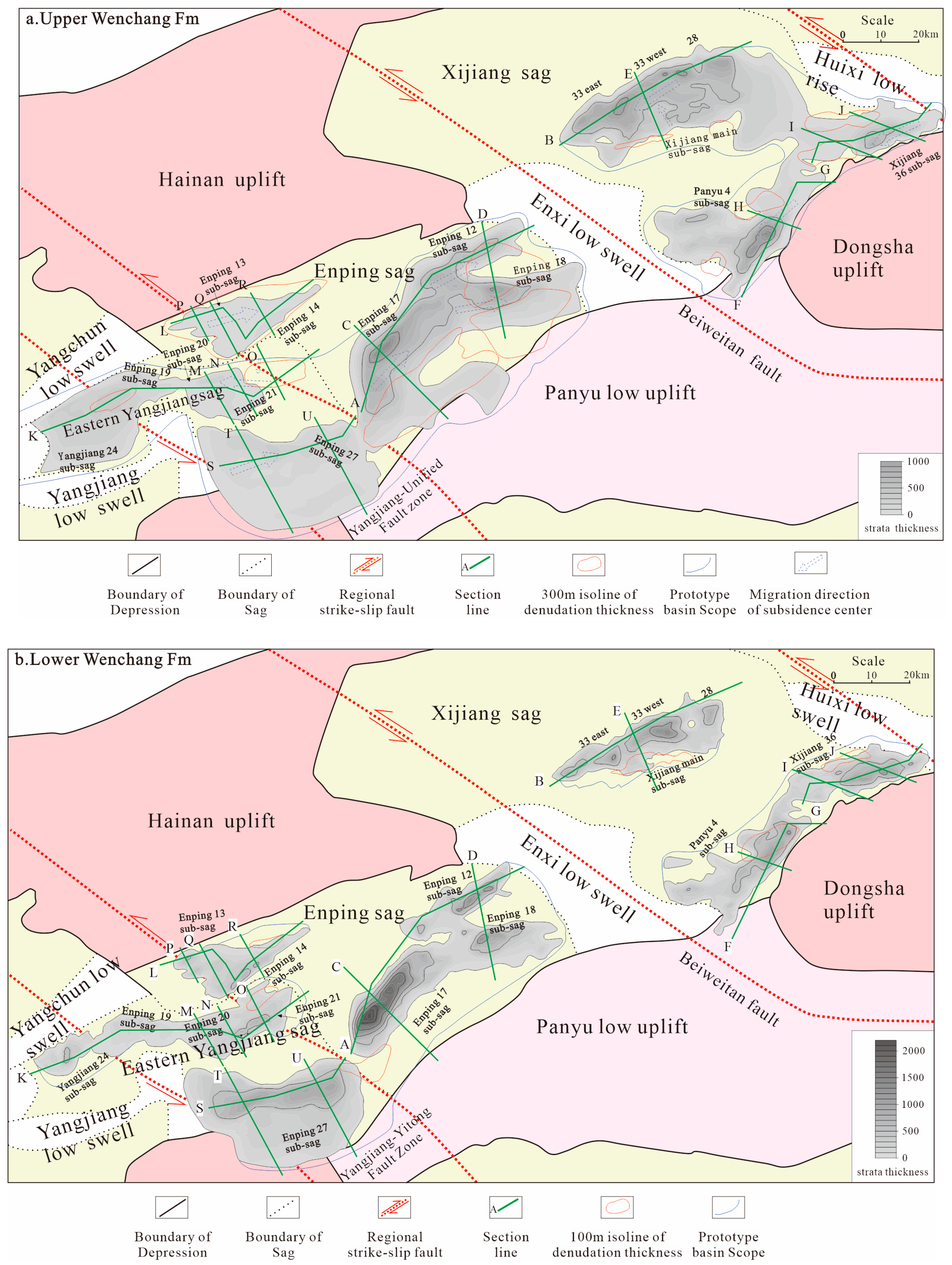
The occurrence and distribution of the basin-controlling faults at the E2WC stage were related to the preexisting faults in the Mesozoic basement. During subsag development at the E2WC stage and E2+3EP stage, the regional extension direction rotated from NW–SE to S–N. In addition to the development of NE-, ENE-, and nearly E-W-trending basin-controlling faults, a series of NW-trending regional strike-slip faults developed in the region, such as the Beiweitan Fault and Yangjiang-Yitong Fault Zone. Regarding the simple half-graben controlled by a single fault, the migration of the Wenchang Fm subsidence centre was relatively simple. As a whole, subsags such as the Xijiang main subsag in the Xijiang Sag migrated along the basin-controlling fault to the southwest, and subsags such as the 17 subsags of Enping in the Enping Sag migrated along the basin-controlling fault to the northeast. The Xijiang and Enping sags are located on both sides of the Beiweitan fault. Structural transformation occurred during the change in the regional extension direction. The location of the Beiweitan Fault changed from high to low, and the subsidence centres migrated near to the Beiweitan fault in a convergent manner. Close to the Beiweitan fault, the migration directions of the subsidence centre deviated from the basin-controlling fault direction. For example, the basin-controlling fault of the Panyu 4 subsag is NE-trending, the subsag migrated to the southwest at the late E2WC stage, and the northwest part was formed, which exhibits the same trend of the boundary fault as that of the Beiweitan Fault (Figure 6a,b and Figure 7). The magmatic activity at the early and late E2WC stages led to different directions of local deposition and regional migration of the Upper Wenchang Fm, and the magmatic activity at the E2+3EP stage played a leading role in reforming the subsag structure only (Figure 7).
In the Yangjiang-Yitong Fault Zone, two complex compound half-grabens are controlled by two faults with opposing dips. The migration of the Wenchang Fm subsidence centre is more complex. As a whole, the subsidence centre migrated northwestwards in the Enping 20 and 21 subsags and northeastwards in the Enping 27 subsag. The Enping 19 subsag and Yangjiang 24 subsag are located outside of the Yangjiang-Yitong Fault Zone, and their subsidence centres migrated northwestwards. The migration direction of the Wenchang Fm in the Enping 27 subsag is the opposite to that of the northern Enping 20 and 21 subsags. This is consistent with the migration direction of the Enping 17 subsag. There may be two reasons for this phenomenon. The first reason is that magmatic activity at the E2WC stage in the gentle slope zone of the Enping 20 and 21 subsags intensified the uplift, which caused the subsidence centre to migrate to the northwest. The suspected magmatic activity in the western part of the Enping 27 subsag also led to the eastward migration of the subsidence centre. This may result in the migration direction of the subsidence centre of the Enping 27 subsags opposing that of the Enping 20 and 21 subsags. Of course, this reason is less likely because magmatic activity is not fully supported by the obtained seismic data. Another reason is that the magmatic activity at the E2WC and E2+3EP stages developed only in the Enping 20 and 21 subsags, which are situated at the northernmost end of the Yangjiang-Yitong Fault Zone. There was no magmatic activity at the E2WC and E2+3EP stages in the Enping 27 subsag, so the migration pattern is the same as that in the Enping 17 subsag. Large-scale activity of the Yangjiang-Yitong Fault Zone occurred at the N1ZJ, N1HJ, and N1YH stages. Except for the northernmost end of most of the fault zone, most of the zone has the same structural attitude as that of the Zhu I Depression at the E2WC stage (Figure 6a,b and Figure 7). From the perspective of seismic reflection characteristics, there was no obvious truncation on the top of the upper and lower Wenchang Fms in the Enping 27 sag, and a small erosion thickness is another piece of evidence that supports the second reason (Figure 7).

5. Discussion

5.1. Analysis of the Genesis of Magmatic Activity Dynamics

The PRMB in the northern continental margin of the South China Sea is located at the intersection of the Pacific tectonic domain and the Neo-Tethys tectonic domain. Since the Mesozoic, it experienced the interaction of active and passive continental margins and was persistently affected by the Indian plate and the Pacific plate [43]. Since the Cenozoic, the two-way convergence rates and directions of the Pacific plate and Indian plate towards the Eurasian plate continuously changed. Whether the Pacific plate or the India plate plays a leading role in tectonic evolution and magmatic activity is controversial [44,45,46]. In this study, magmatic activity was manifested as development early in the east and late in the west. The location, shape, and distribution of magma intrusion are related to the angle between the regional extension direction and the axis of the basin and are also related to the fault occurrence. This result matches the perspective that the Pacific plate plays a dominant role. During the early Eocene (E2WC stage), the convergence rate of the Indian plate was higher. The convergence direction of the Pacific plate was NWW, and the regional extension direction of the northern continental margin of the South China Sea was NW–SE. The extension direction continuously rotated clockwise, the convergence direction of the Pacific plate changed to NNW, and the extension direction changed to S–N [40,41,42,43]. There was also magmatic activity at the E2WC stage at the northernmost end of the Yangjiang-Yitong Fault Zone [47]. However, in addition to dynamic genesis, magmatic activity is related to many factors, such as crust–mantle evolution, which should be further studied.

5.2. Tectonic Transformation and Magmatic Activity

The primary cause of rift basin subsidence is fault activity. From a macroscopic point of view, regional tectonic activity generates fault activity, and the change in the regional extension direction leads to the transformation of the fault occurrence and offset. Fault and magmatic activity interact; notably, magmatic activity is also the result of regional tectonic activity, and the location of deep and high fault activity could possibly facilitate dike propagation development. The dialectical relationship between tectonic transformation and magmatic activity is difficult to clarify [48,49]. The prediction of the location of magmatic activity in this study is basically consistent with the results of previous laboratory simulations [12,14]. The Yangjiang-Yitong Fault Zone is a validated strike-slip fault zone, and it is understandable that tectonic transformation and magmatic activity exist in its inner basin. The Beiweitan Fault has an undefined evolutionary history, and its strike is parallel to that of the Yangjiang-Yitong Fault Zone [50,51]. The Enping Sag and Xijiang Sag are located on both sides of the Beiweitan fault, and the subsags in these two sags should experience similar tectonic transformation processes and magmatic activity levels. However, deep and large faults are developed in both sags, and the patterns of magmatic activity differ significantly. Magmatic activity may not depend on faults, and dike propagation may be slightly affected by faults [49,50]. If the magmatic activity in each depression is more complex, the main controlling factors of the migration of the subsidence centre could be more difficult to characterize. Therefore, it is reasonable to accept that tectonic transformation is the root cause of subsidence centre migration in this study.

6. Conclusions

  • Although the drilling data for the study area reveal fewer magmatic rocks, the seismic data reflect more obvious magmatic activity here. For example, the intermediate-basic lava showed a medium-high frequency, large amplitude, suitable continuity, and parallel–subparallel reflections in the form of tabular and shields. The lava is subcircular or elliptical in the plane. It is manifested as a hypabyssal magmatic intrusion of a magmatic diapir, which can be identified by a large-amplitude abnormal geological body and convex reflection in the basement. The magmatic activity time in the study area is generally characterized by early development in the east and late development in the west. However, in the Yangjiang-Yitong Fault Zone, magmatic activity is very complicated. At the northernmost end, the magmatic activity in the Enping 20 and 21 subsags developed at the E2WC and E2+3EP stages. To the south, the magmatic activity in the Enping 27 subsag developed at the N1ZJ, N1HJ, and N1YH stages. During the formation period of the fault basin, the location of magmatic activity depended on the angle between the regional stress direction and the axis of the basin. The regional stress rotated from NW–SE to S–N at the E2WC stage, and the angle between the regional stress and the axis of the basin was greater than 45° and changed constantly. The magmatic activity in the eastern Yangjiang-Yitong Fault Zone was more complex than that in the Zhu I Depression.
  • The PRMB at the northern continental margin of the South China Sea is located at the intersection of the Pacific tectonic domain and the Neo-Tethys tectonic domain. Since the Mesozoic, it experienced the interaction of active and passive continental margins and was greatly affected by the Indian plate and the Pacific plate. Since the Cenozoic, the two-way convergence rates and directions of the Pacific plate and Indian plate towards the Eurasian plate continuously changed. Whether the Pacific plate or the Indian plate plays a leading role in tectonic evolution and magmatic activity remains controversial. In this study, magmatic activity was manifested as early development in the east and late development in the west. The location, shape, and distribution of magma intrusion are related to the angle between the regional extension direction and the axis of the basin and are also related to the fault occurrence. This result matches the perspective that the Pacific plate plays a dominant role. During the early Eocene (E2WC stage), the convergence rate of the Indian plate was higher. The convergence direction of the Pacific plate was NWW, and the regional extension direction of the northern continental margin of the South China Sea was NW–SE. The extension direction continuously rotated clockwise, the convergence direction of the Pacific plate changed to NNW, and the extension direction changed to S–N. There was also magmatic activity in the E2WC stage at the northernmost end of the Yangjiang-Yitong Fault Zone. However, in addition to dynamic genesis, magmatic activity is related to many factors, such as crust–mantle evolution, which must be further investigated.
  • At the E2WC and E2+3EP stages, the regional extension direction rotated, and NW-trending regional strike-slip faults were active. The basin-controlling faults were NE, NEE, and nearly E–W faults, and their activities differed along the fault strikes. Tectonic transformation led to the migration of the basin subsidence centre at the E2WC stage. In the Xijiang Sag and Enping Sag, the subsags at the E2WC stage were simple compound half-grabens. The subsidence centre of the subsags migrated along the opposite direction, which suggests that it migrated in a convergent manner towards the NW-striking Beiweitan Fault along the basin-controlling fault. On account of the magmatic activity from the end of the early E2WC stage to the beginning of the late E2WC stage, in the central part of the Xijiang main subsag, the subsidence centre migrated towards the basin-controlling fault. In the northern part of Panyu, 4 subsags were intensely uplifted, and the subsidence centre migrated to the southwest. The subsags in the Yangjiang-Yitong Fault Zone are complex compound half-grabens. The basin-controlling faults of the subsags strike nearly E–W, and their inclinations are opposite. The faults control the subsidence of the subsags, so the subsags partially overlap. Under the influence of E2WC stage magmatic activity, the subsidence centre migrated obliquely from one subsag to the opposite one. In conclusion, against the background of the rotation of the regional extension direction, at the E2WC stage, both tectonic transformation and magmatic activity controlled the subsidence centre migration process. AT the E2+3EP stage and Miocene, magmatic activity changed the subsags formed at the E2WC stage.

Author Contributions

Conceptualization, G.P., G.H. and X.S.; methodology, P.L., X.S. and Z.L.; software, Z.L.; validation, G.P., P.L. and W.C.; formal analysis, X.S.; investigation, G.P. and W.C.; resources, G.P.; data curation, G.P. and Z.Z.; writing—original draft preparation, G.P.; writing—review and editing, P.L. and G.H.; visualization, X.W.; supervision, P.L. and G.H.; project administration, G.P.; funding acquisition, G.P. All authors have read and agreed to the published version of the manuscript.

Funding

This research was funded by Offshore deep/ultra deep oil and gas exploration technology, The significant science and technology project of the 14th Five-Year Plan in CNOOC, No. KJGG2022-0403.

Institutional Review Board Statement

Not applicable.

Informed Consent Statement

Not applicable.

Data Availability Statement

Not applicable.

Acknowledgments

We appreciate the Offshore deep/ultra deep oil and gas exploration technology, The significant science and technology project of the 14th Five-Year Plan in CNOOC.

Conflicts of Interest

The authors declare no conflict of interest.

References

  1. Clinton, D.; Dahlstrom, A. Structural geology in the eastern margin of the canadian rocky mountains. Bull. Can. Pet. Geol. 1970, 18, 332–406. [Google Scholar]
  2. Morley, C.K.; Nelson, R.A.; Patton, T.L.; Munn, S.G. Transfer zones in the East African Rift system and their relevance to hydrocarbon exploration in rifts. AAPG Bull. Am. Assoc. Pet. Geol. 1990, 74, 1234–1253. [Google Scholar]
  3. Henry, D.C. Basement-controlled transfer zones in an area of low-magnitude extension, eastern Basin and Range province, Trans-Pecos Texas. Spec. Pap. Geol. Soc. Am. 1998, 323, 75–88. [Google Scholar]
  4. Ebinger, C.J. Geometric and kinematic development of border faults and accommodation zones, Kivu-Rusizi Rift, Africa. Tectonics. 1989, 8, 117–133. [Google Scholar] [CrossRef]
  5. Chen, J.F.; Wang, X.W.; Chen, Z.N. Analysis of Transform Structures in Extensional Fault Depressions. Geoscience 2011, 25, 9, (In Chinese with English Abstract). [Google Scholar]
  6. Corti, G. Continental rift evolution: From rift initiation to incipient break-up in the Main Ethiopian Rift, East Africa. Earth-Sci. Rev. 2009, 96, 1–53. [Google Scholar] [CrossRef]
  7. Lin, H.M.; Liu, P.; Wang, X.D.; Jia, P.M.; Li, Z.S.; Gao, X.; Que, X.M. Influences of Structural Transformation on Source-to-sink System During the Depositional Period of Wenchang Formation of Eocene in the Zhu I Depression. Geotecton. Metallog. 2021, 45, 13, (In Chinese with English Abstract). [Google Scholar]
  8. Schlische, R.W.; Withjack, M.O. Origin of fault domains and fault-domain boundaries (transfer zones and accommodation zones) in extensional provinces: Result of random nucleation and self-organized fault growth. J. Struct. Geol. 2009, 31, 910–925. [Google Scholar] [CrossRef]
  9. Zhu, H.T.; Xu, C.G.; Zhu, X.M.; Zeng, H.L.; Jiang, Z.X.; Liu, K.Y. Advances of the Source-to-Sink Units and Coupling Model Research in Continental Basin. Earth Sci. J. China Univ. Geosci. 2017, 42, 20. [Google Scholar]
  10. Badr, R.; El-Barkooky, A.N.; El-Araby, A.-M.; Christie-Blick, N.; Bernhardt, A. Syn-rift sedimentary response to growth folding along a rift-margin transfer zone: An example from the early Miocene of the Gulf of Suez, Egypt. Sediment. Geol. 2022, 432, 106121. [Google Scholar] [CrossRef]
  11. Corti, G.; Bonini, M.; Cloetingh, S.; Innocenti, F.; Manetti, P.; Sokoutis, D. Analogue modelling of continental extension: A review focused on the relations between the patterns of deformation and the presence of magma. Earth-Sci. Rev. 2003, 63, 169–247. [Google Scholar] [CrossRef]
  12. Corti, G.; Bonini, M.; Mazzarini, F.; Boccaletti, M.; Innocenti, F.; Manetti, P.; Mulugeta, G.; Sokoutis, D. Magma-induced strain localization in centrifuge models of transfer zones. Tectonophysics 2002, 348, 205–218. [Google Scholar] [CrossRef]
  13. Corti, G.; Bonini, M.; Innocenti, F.; Cloetingh, S.; Mulugeta, G.; Sokoutis, D.; Manetti, P. Rift-parallel magma migration and localisation of magmatic activity in transfer zones. Acta Vulcanol. 2003, 14, 17. [Google Scholar]
  14. Sun, Z.; Pang, X.; Zhong, Z.H.; Zhou, D.; Chen, C.M.; Hao, L.J.; He, M.; Huang, C.J.; Xu, H.H. Dynamics of Tertiary tectonic evolution of the Baiyun Sag in the Pearl River Mouth Basin. Earth Sci. Front. 2005, 12, 489–498, (In Chinese with English Abstract). [Google Scholar]
  15. Pang, X.; Zhen, J.Y.; Mei, L.F. Structural diversity of fault depressions under the background of preexisting subduction continental margin, Pearl River Mouth Basin, China. Pet. Explor. Dev. 2021, 48, 1–11. [Google Scholar] [CrossRef]
  16. Morley, C.K. Geometry and evolution of low-angle normal faults (LANF) within a Cenozoic high-angle rift system, Thailand: Implications for sedimentology and the mechanisms of LANF development. Tectonics 2009, 28. [Google Scholar] [CrossRef]
  17. Shen, M.R.; Shan, X.L.; Hao, G.L.; Liu, P.; Jia, P.M.; Xu, C.; Zhang, Z.W.; Wang, X.M. Structural difference and control mechanism of early Cenozoic depression in Yangjiang east sag, Pearl River Mouth Basin. Earth Sci. 2022; in press. (In Chinese with English Abstract). [Google Scholar]
  18. Parsons, T.; Thompson, G.A. Does magmatism influence low-angle normal faulting? Geology 1993, 21, 247–250. [Google Scholar] [CrossRef]
  19. Zhao, Y.H.; Ren, J.Y.; Pang, X.; Yang, L.L.; Zheng, J.Y. Structural style, formation of low angle normal fault and its controls on the evolution of Baiyun Rift, northern margin of the South China Sea. Mar. Pet. Geol. 2018, 89, 687–700. [Google Scholar] [CrossRef]
  20. Weinstein, A.; Oliva, S.J.; Ebinger, C.J.; Roecker, S.; Tiberi, C.; Aman, M.; Lambert, C.; Witkin, E.; Albaric, J.; Gautier, S.; et al. Fault-magma interactions during early continental rifting: Seismicity of the Magadi-Natron-Manyara basins, Africa. Geochem. Geophys. Geosyst. 2017, 18, 3662–3686. [Google Scholar] [CrossRef]
  21. Derek, K.; Ebinger, C.J.; Stuart, G.W.; Daly, E.; Ayele, A. Strain accommodation by magmatism and faulting as rifting proceeds to breakup: Seismicity of the northern Ethiopian rift. J. Geophys. Res. Solid Earth 2006, 111, 1–17. [Google Scholar] [CrossRef]
  22. James, E.F.; Robert, J.V. The role of accommodation zones and transfer zones in the regional segmentation of extended terranes. Geol. Soc. Am. Spec. Pap. 1998, 323, 1–45. [Google Scholar]
  23. Shi, H.S.; Du, J.Y.; Mei, L.F.; Zhang, X.T.; Hao, S.H.; Liu, P.; Deng, P.; Zhang, Q. Huizhou Movement and its significance in Pearl River Mouth Basin, China. Pet. Explor. Dev. 2020, 47, 447–461. [Google Scholar] [CrossRef]
  24. Wang, P.C.; Suo, Y.H.; Peng, G.R.; Li, S.Z.; Du, X.D.; Cao, X.Z.; Zhou, J.; Wang, G.Z.; Santosh, M.; Jiang, S.H.; et al. Three-stage extension in the Cenozoic Pearl River Mouth Basin triggering onset of the South China Sea spreading. Gondwana Res. 2022, 1–16. [Google Scholar] [CrossRef]
  25. Peng, G.R.; Pang, X.Q.; Xu, Z.; Luo, J.R.; Yu, S.; Li, H.B.; Hu, T.; Wang, C.; Liu, Y. Characteristics of Paleogene Whole Petroleum System and Orderly Distribution of Oil and Gas Reservoirs in South Lufeng Depression, Pearl River Mouth Basin. Earth Sci. 2022, 47, 2494–2508, (In Chinese with English Abstract). [Google Scholar]
  26. Tian, L.X. Sedimentary-Reservoir Characteristics under Control of Transfer Model and Implications for Hydrocarbon Exploration in Huizhou Depression, Pearl River Mouth Basin. Earth Sci. 2021, 46, 4043–4056, (In Chinese with English Abstract). [Google Scholar]
  27. Wang, J.H.; Liu, L.H.; Chen, S.H.; Shang, Y.L. Tectonic-sedimentary responses to the second episode of the Zhu-Qiong movement in the Enping Depression, Pearl River Mouth Basin and its regional tectonic significance. Acta Pet. Sin. 2011, 32, 588–595. [Google Scholar]
  28. Pang, G.R.; Zhang, X.T.; Xu, X.M.; Bai, H.J.; Cai, G.F.; Zhao, C.; Zhang, Z.W. Important discoveries and understandings of oil and gas exploration in Yangjiang sag of the Pearl River Mouth Basin, northern South China Sea. China Pet. Explor. 2019, 24, 267–279, (In Chinese with English Abstract). [Google Scholar]
  29. Zhan, C.; Lu, S.P.; Fang, P.G. Multiphase rift and migration mechanism in the Pearl River Mouth Basin. Earth Sci. Front. 2022, 29, 307–318. [Google Scholar]
  30. Huang, C.Y.; Wang, P.X.; Yu, M.M.; You, C.F.; Liu, C.S.; Zhao, X.X.; Shao, L.; Zhong, G.F.; Yumul, G.P. Potential role of strike-slip faults in opening up the South China Sea. Natl. Sci. Rev. 2019, 6, 43–53. [Google Scholar] [CrossRef]
  31. Ye, Q.; Mei, L.F.; Shi, H.S.; Camanni, G.; Shu, Y.; Wu, J.; Deng, P.; Li, G. The Late Cretaceous tectonic evolution of the South China Sea area: An overview, and new perspectives from 3D seismic reflection data. Earth-Sci. Rev. 2018, 187, 186–204. [Google Scholar] [CrossRef]
  32. He, M.; Zhong, G.F.; Liu, X.F.; Liu, L.H.; Shen, X.P.; Wu, Z.; Huang, K. Rapid post-rift tectonic subsidence events in the Pearl River Mouth Basin, northern South China Sea margin. J. Asian Earth Sci. 2017, 147, 271–283. [Google Scholar] [CrossRef]
  33. Ren, J.; Pang, X.; Lei, C.; Yuan, L.Z.; Liu, J.; Yang, L.L. Ocean and continent transition in passive continental margins and analysis of lithospheric extension and breakup process: Implication for research of the deepwater basins in the continental margins of South China Sea. Earth Sci. Front. 2015, 22, 102–114. [Google Scholar]
  34. Sun, Z.; Li, F.C.; Lin, J.; Sun, L.T.; Pang, X.; Zhen, J.Y. The Rifting-Breakup Process of the Passive Continental Margin and Its Relationship with Magmatism: The Attribution of the South China Sea. Earth Sci. 2021, 46, 770–789, (In Chinese with English Abstract). [Google Scholar]
  35. Zhang, X.T.; Peng, G.R.; Wang, G.Z.; Liu, X.Y.; Zhao, L.; Yang, Y.; Zhan, H.W.; Yu, H.Y.; Ma, X.Q.; Li, S.Z. Fault response to the Huizhou Movement in the Pearl River Mouth Basin: Insights from a case study of the Eastern Yangjiang Sag. Earth Sci. Front. 2022, 29, 161–175, (In Chinese with English Abstract). [Google Scholar] [CrossRef]
  36. Chen, S.M.; Jiang, C.J. Seismic Prediction Theory and Method of Volcanic Reservoir in Basin; Science Press: Beijing, China, 2015; (In Chinese with English Abstract). [Google Scholar]
  37. Wang, C.; Sun, Q.L.; Xie, X.N.; Song, H.L. Characteristics and Mechanisms of Shallow Igneous Intrusions and Their Implications on Hydrocarbon Geology in the Baiyun Sag. Earth Sci. 2022, 47, 13, (In Chinese with English Abstract). [Google Scholar]
  38. Gao, Y.D.; Lin, H.M.; Wang, X.D.; Liu, P.; Li, Z.S.; Zhang, Q.; Xiong, W.L. Source rock distribution pattern in an episodic rifting sag and later stage magmatiic reformation: A case from Panyu 4 sag, Zhu I Depression. Mar. Geol. Quat. Geol. 2021, 41, 10, (In Chinese with English Abstract). [Google Scholar]
  39. Xu, C.; Shan, X.L.; Lin, H.M.; Hao, G.L.; Liu, P.; Wang, X.D.; Shen, M.R.; Rexiti, Y.L.K.; Li, K.; Li, Z.S.; et al. The formation of early Eocene organic-rich mudstone in the western Pearl River Mouth Basin, South China: Insight from paleoclimate and hydrothermal activity. Int. J. Coal Geol. 2022, 253, 103957. [Google Scholar] [CrossRef]
  40. Hu, Y.; Wu, Z.P.; Zhong, Z.H.; Zhang, J.T.; Yu, W.G.; Wang, G.Z.; Liu, Y.M.; Wang, S.Y. Characterization and genesis of the Middle and Late Eocene tectonic changes in Zhu 1 Depression of Pearl River Mouth Basin. Oil Gas Geol. 2016, 37, 779–785, (In Chinese with English Abstract). [Google Scholar]
  41. Zhao, Q.; Zhu, H.T.; Zhang, X.T.; Liu, Q.H.; Qiu, X.W.; Li, M. Geomorphologic reconstruction of an uplift in a continental basin with a source-to-sink balance: An example from the Huizhou-Lufeng uplift, Pearl River Mouth Basin, South China Sea. Mar. Pet. Geol. 2021, 128, 1–14. [Google Scholar] [CrossRef]
  42. Jia, P.M.; Zhang, X.T.; Chen, W.T.; Liu, P.; Luo, M.; Wang, W.Y. Tectonic Evolution of Huizhou 21 Buried Hill and Its Control over Deep Oil Accumulations in the Huizhou Sag of Pearl River Mouth Basin. Mar. Geol. Front. 2021, 37, 27–37, (In Chinese with English Abstract). [Google Scholar]
  43. Suo, Y.H.; Li, S.Z.; Dai, L.M.; Liu, X.; Zhou, L.H. Cenozoic tectonic migration and basin evolution in East Asia and its continental margins. Acta Petrol. Sin. 2012, 28, 2602–2618. [Google Scholar]
  44. Zhang, Z.; Zheng, Q.F.; Zhang, H.; Wang, Q.; Shi, Y.L. Late Mesozoic multi-plate convergence in East Asia: Insights from 3-D global mantle flow models. Tectonophysics 2022, 845, 229636. [Google Scholar] [CrossRef]
  45. Li, S.Z.; Jahn, B.M.; Zhao, S.J.; Dai, L.M.; Li, X.Y.; Suo, Y.H.; Guo, L.L.; Wang, Y.M.; Liu, X.C.; Lan, H.Y.; et al. Triassic southeastward subduction of North China Block to South China Block: Insights from new geological, geophysical and geochemical data. Earth-Sci. Rev. 2017, 166, 270–285. [Google Scholar] [CrossRef]
  46. Wang, G.H.; Wang, H.; Gan, H.J.; Liu, E.T.; Xia, C.Y.; Zhao, Y.D.; Chen, S.B.; Zhang, C.C. Paleogene tectonic evolution controls on sequence stratigraphic patterns in the Fushan sag, northern South China Sea. J. Earth Sci. 2016, 27, 654–669. [Google Scholar] [CrossRef]
  47. Cai, G.F.; Zhang, X.T.; Peng, G.R. Neogene Volcanism and Tectonics along the Yangjing-Yitong’ansha Fault Zone in the Northern South China Sea Margin. Geotecton. Metallog. 2021, 45, 40–52, (In Chinese with English Abstract). [Google Scholar]
  48. Zhou, J.; Li, S.Z.; Suo, Y.H.; Li, Z.; Du, X.D.; Cao, X.Z.; Wang, G.Z.; Li, F.K.; Liu, Z.; Liu, J.; et al. NE-trending transtensional faulting in the Pearl River Mouth basin of the Northern South China Sea margin. Gondwana Res. 2022. [Google Scholar] [CrossRef]
  49. Mu, D.L.; Peng, G.R.; Zhu, D.W.; Li, S.Z.; Suo, Y.H.; Zhan, H.W.; Zhao, L.T. Structure and formation mechanism of the Pearl River Mouth Basin: Insights from multi-phase strike-slip motions in the Yangjiang Sag, SE China. J. Asian Earth Sci. 2022, 226, 105081. [Google Scholar] [CrossRef]
  50. Zhang, X.; Bunger, A.P.; Jeffrey, R.G. Mechanics of two interacting magma-driven fractures: A numerical study. J. Geophys. Res.-Solid Earth 2014, 119, 8047–8063. [Google Scholar] [CrossRef]
  51. Jin, Z.H.; Johnson, S.E. Magma-driven multiple dike propagation and fracture toughness of crustal rocks. J. Geophys. Res.-Solid Earth 2008, 113, 60. [Google Scholar] [CrossRef] [Green Version]
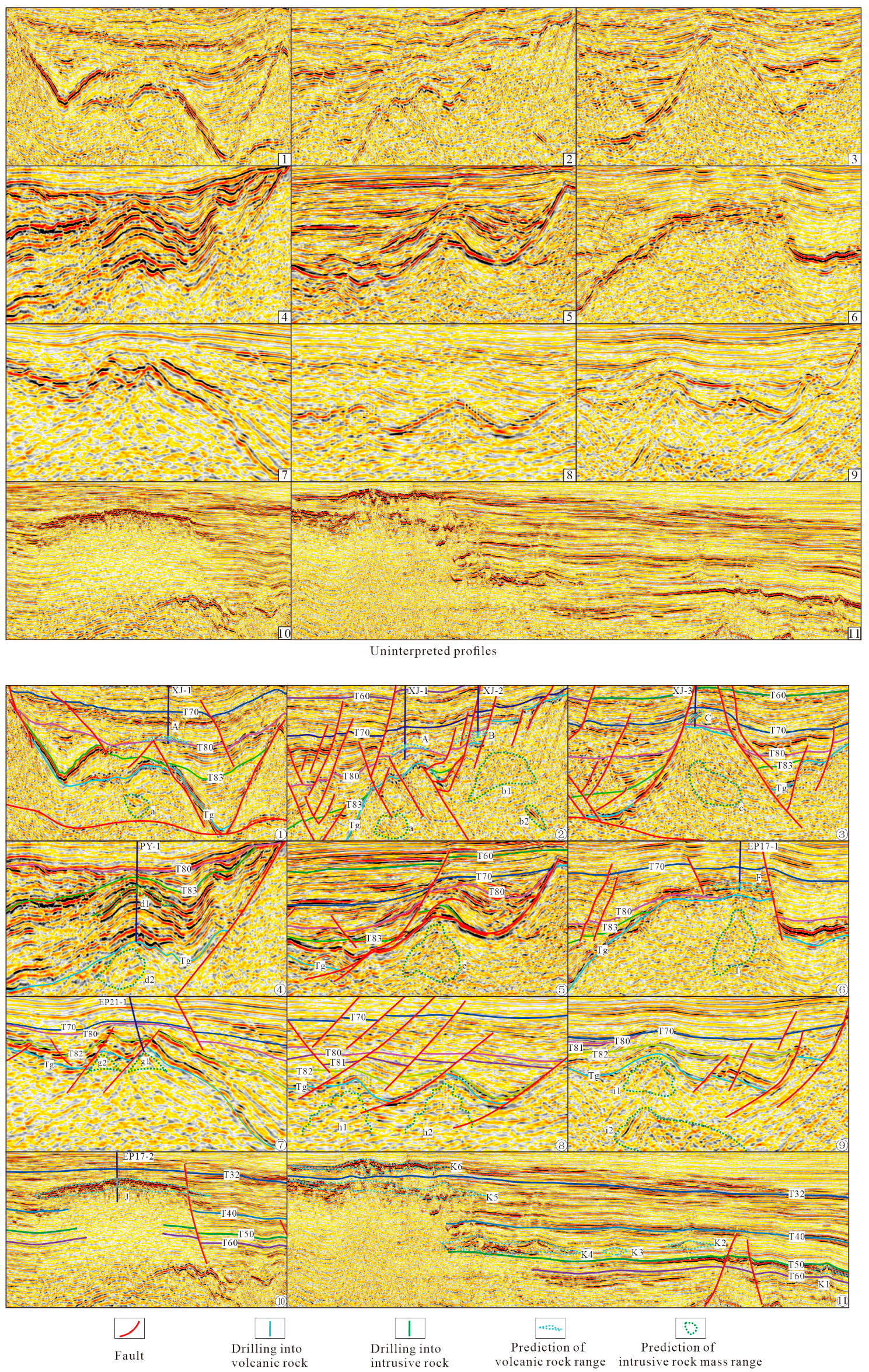
Figure 3. Seismic reflection characteristics of magmatic activity. See Figure 4 for location and Table 1 and Table 2 for exploration.
Jmse 11 00579 g003
Figure 4. Magmatic activity stage and distribution map.
Jmse 11 00579 g004
Figure 5. Migration characteristics and structural section of the E2WC stage basin in the Zhu I Depression. See Figure 6 for location.
Jmse 11 00579 g005aJmse 11 00579 g005b
Figure 6. Thickness and denudation range of the upper and lower Wenchang Formations in the Zhu I Depression.
Jmse 11 00579 g006
Figure 7. Migration pattern of the Wenchang Formation subsidence centre.
Jmse 11 00579 g007
Table 1. Drilling data for Mesozoic–Cenozoic magmatic rocks and distribution layer.
WellboreLocationLithological CharacteristicsLayerSeismic Reflection
XJ-1Xijiang main subsagtuffEnping FmFigure 3①,②
XJ-2Xijiang main subsagbasaltBottom of the Upper Wenchang FmFigure 3
XJ-3Xijiang main subsagbasaltEnping FmFigure 3
PY-1Panyu 4 subsagdiabaseTop of the Lower Wenchang FmFigure 3
EP17-1Enping 17 subsagtuff, andesiteEnping FmFigure 3
EP17-2Enping 17/27sub-sagbasaltHanjiang FmFigure 3
EP17-3Enping 17 subsagtuffEnping Fm-
Table 2. Predictions of magmatic activity.
LocationCode in Figure 2 and Figure 3StageBasis of PredictionSeismic Reflection
Xijiang main subsagA/aEarly E2WC,
Late Early E2WC,
E2+3EP stage
Drilling, platelike reflection, irregular large amplitude in the basement, convex reflection, fault assemblagesFigure 3①,②
B/b1Early E2WC stageFigure 3
C/cE2+3EP stageFigure 3
Panyu 4 subsagd1/d2Early E2WCDrilling, platelike reflection, irregular large amplitude in the basement, convex reflectionFigure 3
Xijiang 36 subsageE2+3EP stageIrregular large amplitude in the basement, convex reflection, fault assemblagesFigure 3
Enping 17 subsagF/fE2+3EP stageDrilling, platelike reflection, irregular large amplitude in the basement, convex reflectionFigure 3
Enping 20/21 subsagg1Early E2WC,
late early E2WC, and
E2+3EP stages
Drilling, irregular large amplitude in the basement, convex reflection, reference [39]Figure 3
g2Early E2WC, late early E2WC, and E2+3EP stagesIrregular large amplitude in the basement, convex reflection, reference [39]
h1Late early stageIrregular large amplitude in the basement, convex reflectionFigure 3
h2Early E2WC stage
Enping 14 subsagi1Early E2WC stageIrregular large amplitude in the basement, convex reflectionFigure 3
Enping 17/27 subsagJN1HJ stageDrilling, platelike reflection, convex reflectionFigure 3
Enping 27 subsagK1, K2, K3, K4N1ZJ stagePlatelike reflection, convex reflectionFigure 3
K5N1HJ stage
K6N1YH stage
Disclaimer/Publisher’s Note: The statements, opinions and data contained in all publications are solely those of the individual author(s) and contributor(s) and not of MDPI and/or the editor(s). MDPI and/or the editor(s) disclaim responsibility for any injury to people or property resulting from any ideas, methods, instructions or products referred to in the content.