Article

Assessing the Spatio-Temporal Features and Mechanisms of Symmetric Instability Activity Probability in the Central Part of the South China Sea Based on a Regional Ocean Model

College of Meteorology and Oceanography, National University of Defense Technology, Changsha 410073, China
*
Author to whom correspondence should be addressed.
J. Mar. Sci. Eng. 2023, 11(2), 431; https://doi.org/10.3390/jmse11020431
Submission received: 31 October 2022 / Revised: 8 December 2022 / Accepted: 10 December 2022 / Published: 16 February 2023
(This article belongs to the Special Issue Frontiers in Physical Oceanography)

Abstract

:
Symmetric instability (SI) is credited with one of the important submesoscale instabilities. However, due to its small scales, it is challenging to capture using current observational measurements and ocean models. Estimates of SI activity are useful for assessing whether SI should be parameterized. Based on a high-resolution ocean model, we use a criterion to assess the spatio-temporal features of SI activity without directly solving SI in the Xisha–Zhongsha waters. An Ertel potential vorticity (PV) analysis is performed, and the negative PV injection and frontal tendency are calculated to analyze the generation mechanisms. The results show that the activity of SI is strongly seasonal. In comparison, SI is active in winter, but it is inactive in summer. In addition, it is mainly found within the ocean surface mixed layer (SML), and it almost disappears in the base of the surface mixed layer (BML). Moreover, the vertical component of the Ertel PV leads to the vertical spatial difference of SI activity, and both the vertical component of the Ertel PV and the sea surface buoyancy flux play an important role in the seasonality of SI activity. The stronger frontogenesis around the Xisha Islands partially accounts for the horizontal distribution difference of SI. This work implies that the parameterization of SI may have potential value in practical application in this region in winter due to the high probability of SI activity.

1. Introduction

Oceanic submesoscale processes (submesoscales, hereinafter) are characterized by order one Rossby and Richardson numbers, and they have temporal and spatial scales of O (0.1–10) days and O (0.1–10) km, respectively [1,2,3]. The submesoscales provide an important route for the energy cascade between mesoscale progress and small-scale turbulence [4,5,6,7], and they play a crucial role in the vertical transport of heat, salt, and nutrients [8,9]. The main dynamic instability mechanisms driving submesoscales include mixed layer instability (MLI), SI, lateral shear instability and barotropic conversion, and centrifugal instability [4]. The focus of this paper, SI, has been previously reported to make important contributions to ocean mixing and the forward energy cascade [10,11]. SI requires rotation and density variation around the fronts, and it partially accounts for the SML submesoscale activity [12].
The South China Sea (SCS) is one of the most complex marginal seas in the world, with abundant and active multi-scale dynamic processes [13,14]. Located in the central part of the SCS (Figure 1), the Xisha–Zhongsha waters are affected by the strong disturbance of the Pacific Ocean penetrating the Luzon Strait into the SCS. Meanwhile, the seasonally reversing East Asia monsoon strongly influences this region. Furthermore, with it having many islands and seamounts, the seabed of the Xisha–Zhongsha waters is undulating. The above dynamic conditions favor the generation of submesoscales [1,15,16].
However, obtaining observations of SI in the ocean is especially difficult because the fronts are often ephemeral. Up until now, there has been no observational study on SI activity in the Xisha–Zhongsha waters (even in the SCS). In the numerical simulation research, based on 1/30° numerical simulation results, Zhang, Zhang, Qiu, Sasaki, Sun, Zhang, Zhao and Tian [15] estimated the probability of SI activity in the northern SCS, and they thought that the simulations with a higher spatial resolution are required to assess SI activity. Using a MITgcm model (named as LLC4320) with a grid spacing of 1/48°, Dong et al. [17] assess the activity of SI in most of the globe. Nevertheless, the activity of SI relies on larger submesoscale fronts (i.e., MLI) resolved in a model [17,18,19]. Therefore, the complete resolution of MLI is a precondition for making accurate estimations of the SI activity. However, in LLC4320, an only partial MLI (at less than 50% of grid points according to Dong et al. [20]) was resolved, so the activity of SI is inevitably underestimated. Moreover, the estimation of SI activity is only derived from the realistic simulation over approximately a year, so the result may be affected by contingency or particularity. In addition, as SI cannot be resolved by most of the current ocean or climate models, a parameterization of SI in the SML [18] has been proposed (hereinafter, B17). However, the precondition for the activation of B17 is to meet the conditions for the occurrence of forced SI (c.f. B17), so the assessment of the SI activity can reflect whether B17 or another SI parameterization is worth applying in the Xisha–Zhongsha waters.
Therefore, based on nested higher resolution and longer realistic simulations, this study investigates the spatio-temporal features of SI activity in the Xisha–Zhongsha waters, and the potential value of implementing B17 or another SI parameterization was determined. The remainder of this paper is organized as follows: Section 2 describes the data, model setup, and the criterion for assessing the SI activity. Section 3 validates the model performance and presents the spatio-temporal characteristics of SI activity. Section 4 probes into the inherent mechanisms. Discussion and conclusions are given in Section 5 and Section 6, respectively.

2. Model Description and Methods

2.1. Observation Data

To validate the model, we used in situ observations included the EN4.2.1 T/S profile datasets from the Hadley Center [21]. The EN4.2.1 T/S profile datasets were divided into 24 layers at different depths, namely 2, 5.01, 15.07, 25.28, 35.7, 46.61, 57.98, 70.02, 82.92, 96.92, 112.32, 129.49, 148.96, 171.40, 197.79, 229.48, 268.46, 317.65, 381.39, 465.91, 579.31, 729.35, 918.37, and 1139.15 m. The time range was from 2017 to 2020. We also used data on sea surface temperature (SST) from Optimum Interpolation Sea Surface Temperature-v2.1 (OISST) from 2017 to 2020. It is produced at the National Oceanic and Atmospheric Administration (NOAA), and it has a spatial grid resolution of 0.25° and a temporal resolution of 1 day. It incorporates observations from different platforms (satellites, ships, buoys, and Argo floats) into a regular global grid, and they are interpolated to fill the gaps on the grid. Buoys make reference to satellite and ship observations to compensate for platform differences and sensor biases [22].

2.2. Model Setup

In this study, the Coastal and Regional Ocean COmmunity model (CROCO) was used to conduct a one-way-nested simulation of the Xisha–Zhongsha waters. CROCO is a recent model built upon the ROMS-AGRIF [23]. The simulation in this work was carried out under the hydrostatic approximation.
We choose 1 km as the horizontal resolution for estimating SI activity, and the reasons for this are as follows: The activity of SI relies on larger submesoscale fronts (i.e., MLI) which are resolved in a model [17,18,19], so it is necessary to resolve MLI in this region. Considering that Equation (7) in Dong, Fox-Kemper, Zhang, and Dong [20] estimates the MLI sinusoidal wavelength as the LML, a required grid spacing resolving MLI should be near LML/8 since at least two grid cells per eddy radius (i.e., the Nyquist sampling rate for an eddy radius set to 1/4 the wavelength) are necessary to resolve eddies. According to Dong, Fox-Kemper, Zhang, and Dong [20], the LML with the KPP turbulence closure schemes is the smallest in summer, and the corresponding bounds of the 90th percentile LML values is about 8~10 km at 14° N~18° N. Hence, the required grid spacing resolving 90% of the MLI in this region should be 1~1.25 km. Therefore, going from 2 km (1/48° as in LLC4320) to 1 km would improve the ability to resolve the submesoscale fronts (e.g., MLI), indirectly improve the ability to estimate the SI activity probability.
The offline nesting of CROCO utilizes an approach of successive horizontal grid refinements (Figure 1) from a parent grid of ~5 km (CROCO1) to a nested child grid of ~1 km (CROCO2). The nesting conforms to the general principles of the mesh refinement factor (2~5 times) [24]. Both of them have 32 levels in terrain-following vertical S-coordinates with concentrated levels in the SML. This has the advantages that the coordinate surface changes along the undulation of the terrain, and the vertical resolution is fine in the SML. The grid points of CROCO1 are 461 × 337 × 32, and the grid points of CROCO2 are 601 × 418 × 32. The lateral tracer advection scheme is the split and rotated 3rd-order upstream biased advection scheme, and the surface forcing conditions are used for the bulk formulation for the surface heat fluxes [23]. The K-profile parameterization (KPP) is used for the subgrid vertical mixing of momentum and tracers [25]. The topography used here was provided by ETOPO2 of the National Oceanic and Atmospheric Administration (NOAA). The boundary and initial information driving CROCO1 are from the HYbrid Coordinate Ocean Model (HYCOM) reanalysis data. Surface atmospheric forcing was taken from the National Centers for Environmental Prediction (NCEP) Climate Forecast System Reanalysis (CFSR) and its second edition, Climate Forecast System Version 2 (CFSV2). The simulation includes tidal forcing because tides play a key role in many aspects of regional dynamics of the SCS. The tidal data are derived from TPXO8, including eight main tidal components. Details of the above data are described in Table 1.
CROCO1 reached an equilibrium state after a 10-year realistic simulation from January 2008 to January 2017, and then, it ran for an additional 3 years from January 2017 to January 2020 to provide initial and daily boundary information for CROCO2.

2.3. Definition of SI Activity

At the submesoscales, the negative product of Ertel potential vorticity (PV) q and the local Coriolis parameter f are a precondition of SI [26].
f q = f f k + × v · b < 0  
Once the anticyclonic PV arises, SI can quickly restore PV to a neutral state through mixing highly cyclonic PV from the pycnocline. However, forced SI persists under continued surface negative PV injection [27]. The negative PV injection includes two sources [12,18,28], which are named as Ekman buoyancy flux ( E B F ) and surface buoyancy flux ( B 0 ), respectively. The wind work is conducive to injecting the negative PV through changing the buoyancy field in the SML. The effect of that the Ekman transport the negative PV can be expressed in terms of the E B F that is driven by winds along the fronts:
E B F = M e · h b | z = 0 ,  
M e = τ y f ρ 0 , τ x f ρ 0 ,  
where M e is the Ekman transport, h b is the horizontal gradient of buoyancy, and τ x ,   τ y is the wind stress vector. The other source is the buoyancy flux that occurs due to the exchange of sea surface heat and freshwater, which is given by:
B 0 = B s + B T .
These two items are, respectively:
B S = g β E P S  
and
B T = g α Q n e t _ h e a t ρ 0 C p .  
Here, B S and B T are two types of buoyancy losses caused by freshwater and net heat flux on the sea surface, respectively. Vertical convection occurs when the ocean loses heat, which is indicated with positive B S or positive B T [12,17,18]. α is the thermal expansion coefficient (unit: °C−1), and Q n e t _ h e a t is the net heat flux of sea surface (unit: W·m−2). The seawater specific heat capacity C p is 3890 J·kg−1·°C−1. β (unit: PSU−1) is the saline contraction coefficient, and E and P (unit: m·s−1) are the net freshwater exchange that occur due to evaporation and precipitation, respectively. S is the sea surface salinity (unit: PSU).
In the Northern Hemisphere, f is always positive, so the sign of the product of PV and f depends on the sign of PV. However, the negative PV is a necessary, but it is not a sufficient condition for SI to develop [19,26]. It is necessary to identify SI from the other instabilities (centrifugal instability and gravitational instability). According to Dong et al. [29], when PV < 0, the negative baroclinic term of the PV usually is associated with SI. According to Cao and Jing [30], the Ertel PV can be further decomposed into:
q = f + ζ b z q v e r t + k × u z · h b q b c ,  
where b z is the vertical buoyancy gradient and u z is the vertical shear of flow velocity. Here, the vertical component, q v e r t , is related to vorticity and stratification, while the baroclinic component, q b c , is attributed to the lateral buoyancy gradient and the vertical shear of flow velocity. Thus, an additional criterion for SI activity needs to be added as: q b c = k × u z · h b < 0 . We note that we do not consider the hybrid SI to be SI (c.f. Dong et al. [29] for details).
Therefore, when the PV at a point in the mixed layer is negative and both the E B F and the buoyancy flux at the sea surface are positive, it can be assumed that the forced SI event is occurring here. Thus, the criterion for defining SI activity in this study is: f q < 0 , q b c < 0 , E B F > 0 and B 0 > 0 . If the MLI is well resolved, the criterion can assess the potential activity of SI without directly resolve it.

3. Results

3.1. Model Validation

CROCO1 has been validated using observations (i.e., OISST) and reanalysis data (i.e., HYCOM). It indicates a good performance in simulating the SST and horizontal flow field at different water depths, and the details are shown in the Supplementary Materials. In addition, the monthly averaged vertical profiles of CROCO2, HYCOM, and EN4 are shown in Figure 2. By comparing CROCO2 with the reanalysis (HYCOM) and observation data (EN4), we can find that CROCO2 is similar than the other two. It suggests that CROCO2 performs well in all three aspects, although the near-surface salinity is moderately higher. It should not be neglected that the mixed layer and the thermocline in this region seem to have strong seasonality, that is, both of them are deeper in the winter than they are in the summer. In addition, both of the stratifications at the sea surface are weak, but the stratification near the surface increases rapidly with the depth in summer, while the stratification within the depth of about 20 m almost does not become stronger with the increase in water depth in winter.
According to Dong, Fox-Kemper, Zhang, and Dong [20], a grid with ~1 km resolution can resolve most of MLI, so CROCO2 is expected to delineate the local submesoscale frontal features. The instantaneous distributions of SST, sea surface height (SSH) and current, surface Rossby number (vertical relative vorticity normalized by planetary vorticity, i.e., ζ / f ), and vertical velocity at 20 m on 4 December 2018 are illustrated in Figure 3. In general, the SST is cold over the northwestern continental shelf, and there is a warm tongue in the southeastern deep basin. The distribution of the SST and SSH denotes that two mesoscale eddies with the spatial scale of O (100) km can be observed around the warm tongue. The two eddies, which are usually referred to as the “eddy pair”, are common in the SCS [31]. According to the previous studies, the submesoscales are more active at the edge of eddy and over the regions with a complicated topography [1,6], which are verified in Figure 3C,D. The dynamic processes with the Rossby number that is around O (1), including the filaments and fronts, are ubiquitous in the regions, implying that there are numerous occurrences along the submesoscales. Moreover, the strong Rossby number of submesoscales in the upper layer usually indicates strong vertical velocities. It is verified in Figure 3D, where the vertical velocity can reach 0.1 cm/s at the fronts.
In addition, according to the quasi-geostrophic theory, the slope of the kinetic energy power spectrum in the O (10) km scale range is close to k 3 in the SML [32]. However, according to the previous studies, the slope with active submesoscales is close to k 2 [33,34,35]. The spectral estimates for CROCO1 and CROCO2 are provided to highlight the changes in the energy content as the resolution increases (Figure 4). It shows that the slope of the kinetic energy power spectra in CROCO1 is k−3, approximately, and t is even steeper in the range of a wavenumber that is larger than 8 × 10⁻⁴ m−1 (wavelength that is smaller than 80 km). However, the slope in CROCO2 is almost k−2. The difference is most obvious in the wavelength range of 10~100 km (within the ellipse in Figure 4). The above spectral characteristics indicate that CROCO2 has a better performance in the simulated submesoscale processes with a spatial scale of more than 10 km. All of the above characteristics are consistent with the law of submesoscale processes that were obtained from the observations [3,36]. According to Dong, Fox-Kemper, Zhang, and Dong [20], the horizontal scale of MLI in this region is about O (10) km so CROCO2 can resolve the MLI well from the perspective of the kinetic energy spectrum. In summary, CROCO2 can be used to assess the SI activity probability.

3.2. The Spatio-Temporal Features of SI Activity

The SI activity regions on 4 December 2018 are shown in Figure 5A. It compares favorably with the horizontal density gradient distribution shown in Figure 5B, implying that SI is associated with strong (i.e., large horizontal buoyancy gradient) fronts. According to Thompson et al. [37], the density gradient likely results from the eddy-driven density flux or the heterogeneous restratification in the mixed layer, and this could subsequently drive strong ageostrophic motions through processes such as SI. Furthermore, frontogenesis is expected to further reduce the horizontal scale and increase the Rossby number, making it easier for the occurrence of ageostrophic motion and instability to be near the front [38]. So, we use the frontal tendency to diagnose the frontogenesis at the same time. Positive values of the frontal tendency:
F T = ρ x 2 u x + ρ y 2 v y + ρ x ρ y u y + v x  
where it has been computed following Hoskins [39] and Schubert et al. [40] with the potential density ρ and the associated derivatives marking the frontogenetic regions. We overlayed the result on the SI horizontal distribution snapshot (red line in Figure 5A). The result suggests that SI exists in most of the frontogenetic regions with FT > 0.1 ((kg m−3) km−1)2 day−1. This is due to the fact that the occurrence of SI fundamentally relies on the formation of sharp fronts [26], and SI actually feeds on the vertical shear of the background geostrophic shear production at the fronts [41].
Based on the 6 h output of CROCO2, the occurrence probability of SI activity is defined as:
O P = N t N T ,  
where N t is the time points (the number of instants) with the SI activity, and N T is the whole set of time points in the month. Based on the model output from January 2017 to January 2020, the distribution of the occurrence probability was compared in the summer and winter at depths of 5 m, representing the SML (Figure 6A,B). In the SML, the SI activity regions mainly exist in the Xisha Islands in CROCO2 in the summer, while the OP remains within 5% in most of the other regions. However, the occurrence probability of more than 10% of it is almost ubiquitous in the winter, and it even exceeds 30% in some of the regions. During the other seasons, the values of the OP are between those for the summer and winter (not shown here). It suggests that in the SML, SI is much more active in the winter than it is in the summer.
Furthermore, the activity of SI in the base of the surfaced mixed layer (BML) was also investigated. Considering the seasonal variation of stratification in the mixed layer, the monthly average mixed layer depth (the depth at which the surface potential density decreases by a value of 0.03 kg·m−3 [42]) in the winter and summer was calculated. Therefore, the depth of 20 m and 30 m were taken as the BML in the summer and winter, respectively. The results show that the SI activity in the winter is still higher compared with that in the summer (Figure 6C,D). The occurrence probability in the SML decreases sharply, thus implying the weakening of the SI activity. This suggests that SI has a lower relative likelihood in the BML than it does in the SML.
In summary, the spatio-temporal features of the SI activity are as follows. SI activity has obvious seasonal characteristics, and they are much more active in the winter than they are in the summer. In terms of spatial distribution, its horizontal distribution is characterized by more active SI around the Xisha Islands. Vertically, SI is mainly active in the SML. As the depth increases to the BML, the SI activity almost disappears.
According to the criterion adopted in this study, it can be inferred that the reason for the difference in the vertical distribution of the probability is the difference of the negative PV in the vertical direction. Compared with the SML, the stratification in the BML tends to be stronger, and the lateral density gradient is relatively weaker. Moreover, the negative PV at the sea surface also makes it more difficult to transport into the BML. In addition, it is noteworthy that SI usually maintains a high occurrence probability of activity around the Xisha Islands. The reason for this phenomenon is discussed in Section 5.

4. Mechanisms Analysis

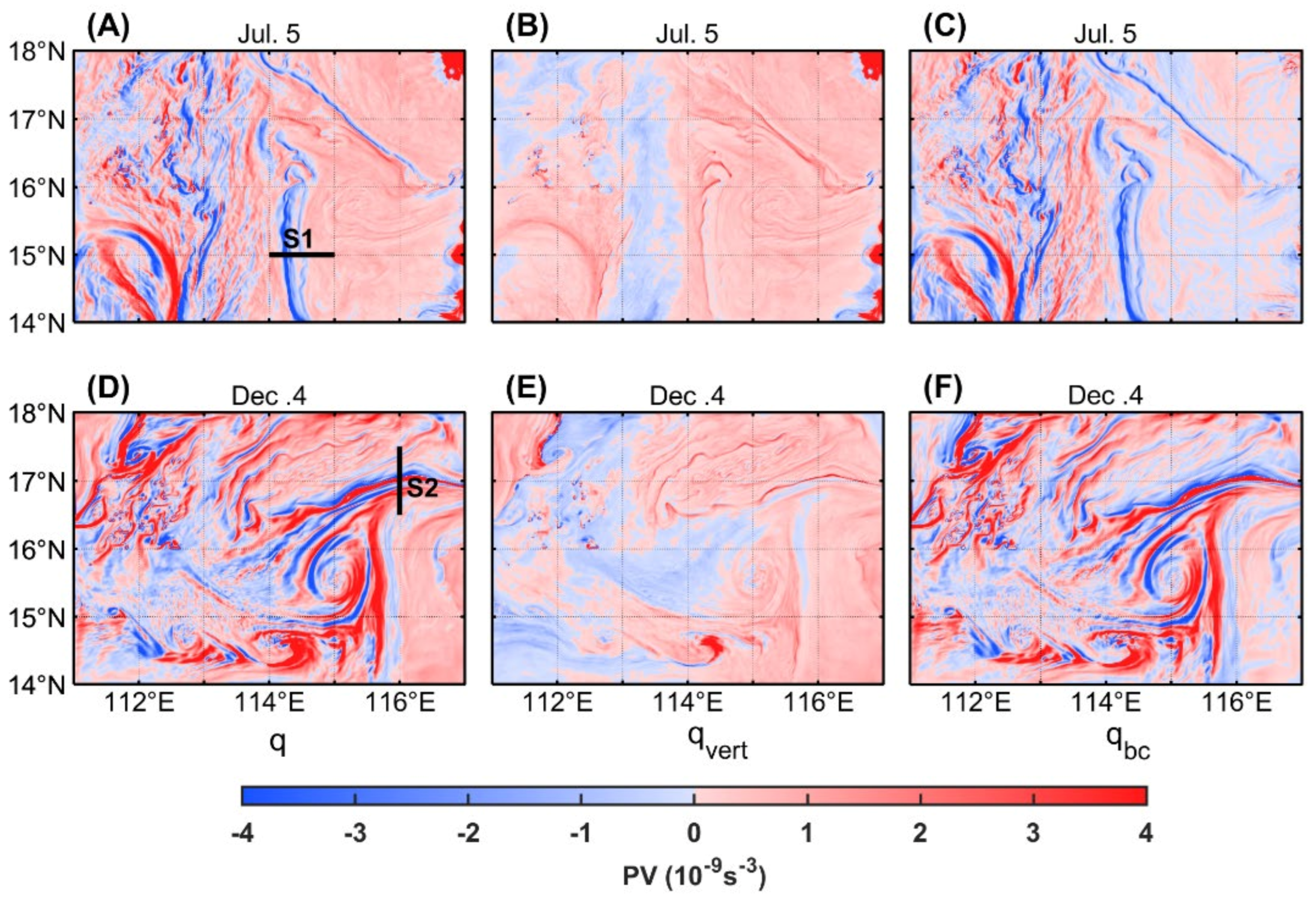
4.1. Ertel Potential Vorticity Analysis

In the northern hemisphere, the negative sign of Ertel PV is a necessary condition for SI. Following Cao and Jing [30], we attempted to examine the near-surface (at 5 m depth) Ertel PV and its sub-components on 5 July and 4 December in order to investigate the generating mechanisms of SI in the rotational and stratified flows.
The potential vorticity decomposition is given in Equation (7), and the two components (the vertical component, q v e r t , and the baroclinic component, q b c ) of Ertel PV were analyzed separately. A negative PV caused by the surface buoyancy flux B 0 is solely from the vertical component. The buoyancy gradient associated with the fronts is necessary to generate the negative baroclinic component of PV for SI. Even when the surface buoyancy flux B 0 results in forced SI, a horizontal buoyancy gradient is also required to provide geostrophic shear as an energy source for the SI. Meanwhile, a positive E B F from down-front winds is also necessary here since this flux provides energy source for sustaining SI. In comparison, the baroclinic component tends to be the dominant constituent for the Ertel PV in most of the near-surface domains whether it occurs in the winter or summer (Figure 7). The q v e r t is near zero in most of the computational domains, which is indicative of a reduced PV for ongoing instabilities. On the contrary, the baroclinic component, q b c , exhibits stronger and denser filamentous structures. In particular, the strong negative q b c along the fronts makes q < 0 be at the near-surface layer, which is favorable for SI. This pattern on 4 December coincides with the distribution of the horizontal gradient of density (recall Figure 5B) arising from the submesoscale frontogenetic processes. Nevertheless, the distribution of the near-surface Ertel PV and its sub-components does not seem to have noticeable seasonal differences. Thus, we have further insight into the vertical profiles of Ertel PV (two typical sections marked in Figure 7A,D).
Both Section 1 and Section 2 cross a front, and there are inclined isopycnals and shallower, mixed-layer depths at the fronts (Figure 8). The Ertel PV with opposite signs to the Coriolis frequency on the inclined isopycnals near flows implies the development of SI [43]. We can infer that if the resolution is fine enough (~0.01 km) to resolve the SI as far as possible, it is expected to show the progress that SI reduces the negative PV, restratifies the SML, and redistributes the tracers along the isopycnals in the mixed layer through vertical mixing [18]. Contrary to the near-surface Ertel PV field, the Ertel PV is gradually controlled by its vertical component with increasing depth, particularly below the mixed layer. The deepened pycnocline below the mixed layer largely strengthens the vertical component by the intensification of the density stratification. We noticed that the baroclinic component acts to balance the vertical component field particularly on the inclined isopycnals, illustrating PV conservation. However, the vertical profiles show pronounced spatial differences in the winter and summer. The depth of the mixed layer is deeper in the winter, and the lateral density gradient in the mixed layer is larger. In addition, there are more negative q values in the vertical profile in the winter, implying that there were more potential SI events. Moreover, the positive q v e r t is weaker in the mixed layer due to the weaker stratification in the winter. The negative q v e r t even exists below the mixed layer near the steep isopycnals (17.1° N), which may cause the SI activity below the mixed layer. According to the definition for instability categories [44], SI would occur at the cross-front section even below the mixed layer. However, the seasonal difference in q b c is moderate, and there are even more positive q b c values in the mixed layer in Section 2 than there are in Section 1.
In order to eliminate the contingency of the snapshots, the monthly averaged near-surface Ertel PV fields were calculated (Figure 9). The vertical component, q v e r t , almost dominates the Ertel PV field, and the strong vertical stratification (i.e., large positive q v e r t ) in the northwest (northeast) of this region increases the Ertel PV in the summer (winter), acting to stabilize the flows. We noticed that the monthly averaged Ertel PV and its two components have seasonal differences. The vertical component tends to be stronger positive values, and the baroclinic component shows stronger negative values in the summer than it does in the winter. However, the combined effects of the vertical component and the baroclinic component makes the values of the Ertel PV smaller in the winter than they are in the summer, thus, partly explaining the reason for the higher occurrence probability of SI in the winter. All of these results suggest that the seasonal variation of the vertical component, q v e r t , dominates the difference of the Ertel PV in the winter and summer.

4.2. Analysis of Two Negative PV Injection

As they are necessary conditions for maintaining the forced SI activity, the E B F and B 0 must be assessed for their effect on seasonal differences in SI activity. Figure 10 shows the spatial distributions of the occurrence probability of E B F > 0 . It can be seen that except in the northwest of this region, the probability of a negative Ertel PV injection through E B F on the sea surface tends to be larger in the summer than that in the winter. It indicates that the facilitation of E B F to SI activity is stronger in the summer, and meanwhile, it implies that the E B F does not play a major role in the seasonal difference of SI activity.
Similarly, the spatial distributions of the occurrence probability of B 0 > 0 on the sea surface are presented in Figure 11. However, in contrast to the seasonality of E B F , the occurrence probability of B 0 > 0 is much higher in the winter than it is in the summer. To further examine this noticeable seasonality, we compared the monthly averaged B 0 and its sub-components in different seasons (Figure 12). The results shows that both of the components have notable seasonality, i.e., both of them are almost positive in the winter and negative in the summer. The reason for a larger B s in the winter can be attributed to the fact that less precipitation occurs in this region in winter and more evaporation occurs due to the positive temperature difference between the sea surface and the air. The larger buoyancy flux due to the exchange of sea surface heat (the sub-component B T ) is mainly because the difference of solar radiation between the winter and summer, and B T accounts for more total buoyancy flux.
In addition, Figure 13 shows the monthly averaged E B F in the different seasons. It shows that the averaged E B F in the summer is positive in most of the regions, and on the contrary, it is almost negative in the winter. According to Figure 12 and Figure 13, the contribution of E B F and B 0 to the averaged injection of PV is the same order of magnitude. Since the SI activity probability is stronger in the winter than it is in the summer, and E B F , as one of the injections of negative PV, is moderately smaller in the winter than it is in the summer, B 0 , as the other injection of negative PV, is larger in the winter than it is in the summer. Therefore, it can be inferred that B 0 is the mainly cause of the seasonality of SI activity probability. Jing, Fox-Kemper, Cao, Zheng, and Du [10] observed similar results in their numerical simulation study. They found that compared with E B F , the sea surface heat loss in the winter is the main source of the negative PV injection, and this supports our conclusion.

5. Discussion

This study lays the foundation for the application of SI parameterization in the Xisha–Zhongsha waters. If we take B17 as an instance, its parameterization does not require a sufficient model resolution to permit SI, but it does require a sufficient resolution to accurately capture the surface PV flux. Our model with a 1 km horizontal resolution can meet the above requirement, that is, B17 is expected to be implemented in CROCO2. In addition, the necessity of SI parameterization depends on whether SI is active in the corresponding region. The higher the frequency of SI activity is, then the effects of SI cannot be ignored and there will be a higher significance for the SI parameterization. Therefore, our research is based on a model that can implement SI parameterization and assesses the seasonality of the SI activity probability. The results show that it is necessary to implement SI parameterization in this region. However, one limitation in this work is that the difference between a convective layer near the surface and a deeper SI-dominated layer that is below it is not considered [26,45]. In addition, the criterion of both E B F > 0 and B 0 > 0 for the forced SI in B17 may underestimate its activity. If a more generous criterion ( f q < 0 , q b c < 0 and E B F + B 0 > 0 ) was applied, the corresponding probability would be obtained (Figure 14). The estimated SI activity is significantly larger than the result is which is estimated with the stricter forcing criterion of both E B F > 0 and B 0 > 0 . Specifically, the probability is more than 1.5 times larger than that which was calculated using stricter criterion in the summer, whether it was in the SML or the BML, but this is not the case in the winter. This difference in magnification between the winter and the summer is because the ocean tends to obtain heat in summer, i.e., the likelihood of B 0 > 0 is smaller than it is in the winter. However, this does not affect the main conclusions in Section 3.
To examine how much of the SI activity probability reported in Section 3.2 are dynamic versus numerically driven, the model with a horizontal resolution of 200 m was generated of the area around Yongxing Island (112° E~112.6° E and 16.55° N~17.15° N, named CROCO3). The grid points of CROCO3 are 301 × 315 × 32. Its initial field and boundary field were obtained by the interpolation of CROCO2, and the accurate locations of some islands and reefs were moderately modified. The output frequency of CROCO3 was increased to once every 3 h, and the other configurations are the same as CROCO2. CROCO3 ran for one month from 1 December 2019, and the kinetic energy and potential energy were stabilized. After that, it continued to run for another one month to obtain the simulation results in January 2020. Then, we calculated the SI activity probability at a 5 m water depth and compared it with the corresponding region in CROCO2 (Figure 15). It shows that the SI activity probability is large around the islands in both of the cases, but generally speaking, the SI activity probability does not increase clearly with the increase in the resolution from 1 km to 200 m. This shows that the previous assessment based on CROCO2 is mainly dynamical driven, rather than numerically driven. We can infer that when the horizontal resolution of this region completely resolves MLI, the assessment of SI activity probability is not sensitive to the horizontal resolution.
In Figure 6, we note that there seems to be a correspondence between the SI activity and the complex topography. SI seems to be more active around the Xisha Islands, and the higher occurrence probability of SI in the BML in the winter is almost constrained in the slope regions of the continental shelf (recall Figure 1 and Figure 6D). For further discussion, based on output of snapshots for the whole domain, Figure 16 shows the averaged frontal tendency in (A) July and (B) January from 2017 to 2019, representing the summer and winter, respectively. The frontogenesis in the winter is more extensive, suggesting that frontogenesis is the potential reason for the seasonality of SI activity probability. In addition, 69% (47%) of the frontogenetic regions with FT > 0.1 ((kg · m−3) km−1)2 day−1 are accompanied by SI activity in the winter (summer), indicating that frontogenesis and frontal processes are key elements of SI activity. However, whether it occurs in the winter or summer, strong frontogenesis exists around the Xisha Islands. The domain-averaged frontal tendency in the white rectangle in Figure 15 is 1.0 × 10⁻⁶((kg · m−3) km−1)2 day−1 in the summer and even 9.7 × 10⁻⁶((kg · m−3) km−1)2 day−1 in the winter, which is much larger than the domain-averaged value in the whole region. The result shows that the strong frontogenesis is the direct reason for the active SI activity around the Xisha Islands. According to the results of Gula, Molemaker, and McWilliams [6], negative values of PV can be spotted in the regions where the flow strongly interacts with the topography. Thus, the reason for the more active SI around the Xisha Islands may be attributed to the following conjectures. The current–topography interactions tend to lead to weaker stratification, and the environment is conducive to the generation of frontogenesis, and thus, this stimulate an abundant number of fronts. The higher horizontal buoyancy gradient across the fronts is conducive to the generation and existence of a negative PV, and also, it provides favorable conditions for the occurrence of SI. Therefore, we can infer that it may be a result of the strong submesoscale fronts due to current–topography interactions, but we still need to conduct finer observations and simulations in the future to demonstrate this.

6. Conclusions

Based on the high-resolution and nested ocean model CROCO, the spatio-temporal features of SI activity in the Xisha–Zhongsha Waters in the South China Sea were analyzed. The results reveal that SI activity region is mainly concentrated in meso- and submesoscale fronts, and they sharply weaken as depth increases (particularly at or below the BML). Hotspots for strong SI activity are around the Xisha Islands. Moreover, SI activity has an obvious seasonal variation, which is more active in the winter than it is in the summer. The results of the spatio-temporal characteristics are sensitive to the variations of the criterion for negative PV injection, but different criteria do not substantially change the present conclusions.
To reveal the mechanism of the spatio-temporal characteristics, we performed the Ertel PV analysis and calculated the two ways that the negative PV injection occurs on the sea surface. The Ertel PV analysis suggests that as the depth increases, the strong stratification causes the vertical component to dominate the Ertel PV field with huge positive values. In terms of near the sea surface, the averaged vertical component is larger in the summer, while the baroclinic component tends to be more negative than that in the winter. The combined effects of the two finally makes the Ertel PV in this region closer to being a negative value in the winter. Furthermore, in comparison, B 0 (mainly contributed by B T ) plays a more important role in the seasonality of SI activity than E B F does. In fact, the baroclinic component of the Ertel PV and E B F play an inhibitory role on the seasonality of SI activity (it does not mean that they suppress SI). Therefore, we can conclude that it is the vertical component of the Ertel PV which leads to the vertical spatial difference of SI activity, and the stronger frontal tendency that may be stimulated by the current–topography interactions account for the more active SI around the islands. The vertical component of the Ertel PV, the sea surface buoyancy flux, and the frontal tendency play important roles in the seasonality of SI activity.
In the SCS, a complex topography and strong internal tides may have a potential impact on SI. Whether the B17 is still applicable in this realistic region is still an open question. To summarize, it is highly significant to implement B17 in the Xisha–Zhongsha waters in the winter because of the high SI activity probability, and the effects of SI in this region in the winter must be further studied in the future.

Supplementary Materials

The following supporting information can be downloaded at: https://www.mdpi.com/article/10.3390/jmse11020431/s1, Figure S1: The monthly averaged SST of (A) CROCO1 and (B) OISST in July, (C) CROCO1 and (D) OISST in January from 2017 to 2019. Figure S2: The monthly averaged circulation of 0m, 1000 m and 2000 m horizontal layers (both velocity arrows at 1000 m depth and 2000 m depth are magnified by 5 times). (A) CROCO1 and (B) HYCOM in July, (C) CROCO1 and (D) HYCOM in January from 2017 to 2019.

Author Contributions

Conceptualization, X.Z. and W.Z.; methodology, Y.J. and X.Z.; software, Y.J. and H.W.; validation, Y.J. and X.Z.; formal analysis, Y.J. and X.Z.; resources, X.Z. and W.Z.; data curation, X.Z.; writing—original draft preparation, Y.J.; writing—review and editing, X.Z. and H.W.; visualization, Y.J.; supervision, X.Z.; project administration, X.Z.; funding acquisition, W.Z. All authors have read and agreed to the published version of the manuscript.

Funding

This research was funded by the National Key Research and Development Program, grant number 2021YFC3101504, and the National Natural Science Foundation of China (42276205).

Institutional Review Board Statement

Not applicable.

Informed Consent Statement

Not applicable.

Data Availability Statement

The dataset of HYCOM analyzed for model setup can be found in the https://www.hycom.org/dataserver/ (accessed on 08 January 2022). The dataset of CFSR and CFSV2 analyzed for this study can be found in the https://rda.ucar.edu/datasets/ds093.0/ (accessed on 17 January 2022) and https://rda.ucar.edu/datasets/ds094.0/ (accessed on 29 January 2022), respectively. The dataset of topography analyzed for this study can be found in the http://www.ngdc.noaa.gov/mgg/global/global.html/ (accessed on 07 January 2022). The dataset of TPXO8 analyzed for this study can be found in the https://www.tpxo.net/global/tpxo8-atlas/ (accessed on 30 January 2022). CROCO and CROCO_TOOLS are provided by http://www.croco-ocean.org (accessed on 08 June 2021). If necessary, please contact the corresponding author to obtain the model output data.

Acknowledgments

We appreciate the institutions or organizations mentioned in the Data Availability Statement. We thank Jihai Dong for the discussion. We appreciate the invaluable suggestions from three anonymous reviewers.

Conflicts of Interest

The authors declare no conflict of interest.

References

  1. McWilliams, J.C. Submesoscale currents in the ocean. Proc. R. Soc. A Math. Phys. Eng. Sci. 2016, 472, 20160117. [Google Scholar] [CrossRef] [PubMed] [Green Version]
  2. Qiu, B.; Chen, S.; Klein, P.; Sasaki, H.; Sasai, Y. Seasonal Mesoscale and Submesoscale Eddy Variability along the North Pacific Subtropical Countercurrent. J. Phys. Oceanogr. 2014, 44, 3079–3098. [Google Scholar] [CrossRef] [Green Version]
  3. Zhang, Z.; Zhang, X.; Qiu, B.; Zhao, W.; Zhou, C.; Huang, X.; Tian, J. Submesoscale Currents in the Subtropical Upper Ocean Observed by Long-Term High-Resolution Mooring Arrays. J. Phys. Oceanogr. 2021, 51, 187–206. [Google Scholar] [CrossRef]
  4. Cao, H.; Fox-Kemper, B.; Jing, Z. Submesoscale eddies in the upper ocean of the kuroshio extension from high-resolution simulation: Energy budget. J. Phys. Oceanogr. 2021, 51, 2181–2201. [Google Scholar] [CrossRef]
  5. Capet, X.; McWilliams, J.C.; Molemaker, M.J.; Shchepetkin, A.F. Mesoscale to Submesoscale Transition in the California Current System. Part III: Energy Balance and Flux. J. Phys. Oceanogr. 2008, 38, 2256–2269. [Google Scholar] [CrossRef] [Green Version]
  6. Gula, J.; Molemaker, M.J.; McWilliams, J.C. Topographic generation of submesoscale centrifugal instability and energy dissipation. Nat. Commun. 2016, 7, 12811. [Google Scholar] [CrossRef] [PubMed] [Green Version]
  7. Yang, Q.; Zhao, W.; Liang, X.; Dong, J.; Tian, J. Elevated Mixing in the Periphery of Mesoscale Eddies in the South China Sea. J. Phys. Oceanogr. 2017, 47, 895–907. [Google Scholar] [CrossRef]
  8. Lévy, M.; Iovino, D.; Resplandy, L.; Klein, P.; Madec, G.; Tréguier, A.M.; Masson, S.; Takahashi, K. Large-scale impacts of submesoscale dynamics on phytoplankton: Local and remote effects. Ocean Model. 2012, 43–44, 77–93. [Google Scholar] [CrossRef]
  9. Su, Z.; Wang, J.; Klein, P.; Thompson, A.F.; Menemenlis, D. Ocean submesoscales as a key component of the global heat budget. Nat. Commun. 2018, 9, 775. [Google Scholar] [CrossRef] [Green Version]
  10. Jing, Z.; Fox-Kemper, B.; Cao, H.; Zheng, R.; Du, Y. Submesoscale Fronts and Their Dynamical Processes Associated with Symmetric Instability in the Northwest Pacific Subtropical Ocean. J. Phys. Oceanogr. 2021, 51, 83–100. [Google Scholar] [CrossRef]
  11. Thomas, L.N.; Taylor, J.R.; D’Asaro, E.A.; Lee, C.M.; Klymak, J.M.; Shcherbina, A. Symmetric Instability, Inertial Oscillations, and Turbulence at the Gulf Stream Front. J. Phys. Oceanogr. 2016, 46, 197–217. [Google Scholar] [CrossRef]
  12. Dong, J.; Fox-Kemper, B.; Zhu, J.; Dong, C. Application of Symmetric Instability Parameterization in the Coastal and Regional Ocean Community Model (CROCO). J. Adv. Model. Earth Syst. 2021, 13, e2020MS002302. [Google Scholar] [CrossRef]
  13. Sun, Z.; Zhang, Z.; Qiu, B.; Zhou, C.; Zhao, W.; Tian, J. Subsurface Mesoscale Eddies Observed in the Northeastern South China Sea: Dynamic Features and Water Mass Transport. J. Phys. Oceanogr. 2022, 52, 841–855. [Google Scholar] [CrossRef]
  14. Zhang, Z.; Zhao, W.; Qiu, B.; Tian, J. Anticyclonic Eddy Sheddings from Kuroshio Loop and the Accompanying Cyclonic Eddy in the Northeastern South China Sea. J. Phys. Oceanogr. 2017, 47, 1243–1259. [Google Scholar] [CrossRef] [Green Version]
  15. Zhang, Z.; Zhang, Y.; Qiu, B.; Sasaki, H.; Sun, Z.; Zhang, X.; Zhao, W.; Tian, J. Spatiotemporal Characteristics and Generation Mechanisms of Submesoscale Currents in the Northeastern South China Sea Revealed by Numerical Simulations. J. Geophys. Res. Ocean. 2020, 125, e2019JC015404. [Google Scholar] [CrossRef]
  16. Cao, H.; Meng, X.; Jing, Z.; Yang, X. High-resolution simulation of upper-ocean submesoscale variability in the South China Sea: Spatial and seasonal dynamical regimes. Acta Oceanol. Sin. 2022, 41, 26–41. [Google Scholar] [CrossRef]
  17. Dong, J.; Fox-Kemper, B.; Zhang, H.; Dong, C. The Scale and Activity of Symmetric Instability Estimated from a Global Submesoscale-Permitting Ocean Model. J. Phys. Oceanogr. 2021, 51, 1655–1670. [Google Scholar] [CrossRef]
  18. Bachman, S.D.; Fox-Kemper, B.; Taylor, J.R.; Thomas, L.N. Parameterization of Frontal Symmetric Instabilities. I: Theory for Resolved Fronts. Ocean Model. 2017, 109, 72–95. [Google Scholar] [CrossRef]
  19. Yu, X.; Naveira Garabato, A.C.; Martin, A.P.; Gwyn Evans, D.; Su, Z. Wind-Forced Symmetric Instability at a Transient Mid-Ocean Front. Geophys. Res. Lett. 2019, 46, 11281–11291. [Google Scholar] [CrossRef] [Green Version]
  20. Dong, J.; Fox-Kemper, B.; Zhang, H.; Dong, C. The Scale of Submesoscale Baroclinic Instability Globally. J. Phys. Oceanogr. 2020, 50, 2649–2667. [Google Scholar] [CrossRef]
  21. Good, S.A.; Martin, M.J.; Rayner, N.A. EN4: Quality controlled ocean temperature and salinity profiles and monthly objective analyses with uncertainty estimates. J. Geophys. Res. Ocean. 2013, 118, 6704–6716. [Google Scholar] [CrossRef]
  22. Huang, B.; Liu, C.; Banzon, V.; Freeman, E.; Graham, G.; Hankins, B.; Smith, T.; Zhang, H.-M. Improvements of the Daily Optimum Interpolation Sea Surface Temperature (DOISST) Version 2.1. J. Clim. 2021, 34, 2923–2939. [Google Scholar] [CrossRef]
  23. Jullien, S.; Caillaud, M.; Benshila, R.; Bordois, L.; Cambon, G.; Dumas, F.; Gentil, S.L.; Lemarié, F.; Marchesiello, P.; Theetten, S. Technical and Numerical Doc. 2019. Available online: https://www.croco-ocean.org/documentation/ (accessed on 8 June 2021).
  24. Debreu, L.; Blayo, E. Two-way embedding algorithms: A review. Ocean. Dyn. 2008, 58, 415–428. [Google Scholar] [CrossRef]
  25. Large, W.G.; McWilliams, J.C.; Doney, S.C. Oceanic vertical mixing: A review and a model with a nonlocal boundary layer parameterization. Rev. Geophys. 1994, 32, 363–403. [Google Scholar] [CrossRef] [Green Version]
  26. Thomas, L.N.; Taylor, J.R.; Ferrari, R.; Joyce, T.M. Symmetric instability in the Gulf Stream. Deep. Sea Res. Part II Top. Stud. Oceanogr. 2013, 91, 96–110. [Google Scholar] [CrossRef]
  27. Thomas, L.N.; Taylor, J.R. Reduction of the usable wind-work on the general circulation by forced symmetric instability. Geophys. Res. Lett. 2010, 37, L18606. [Google Scholar] [CrossRef] [Green Version]
  28. Thomas, L.N. Destruction of Potential Vorticity by Winds. J. Phys. Oceanogr. 2005, 35, 2457–2466. [Google Scholar] [CrossRef]
  29. Dong, J.; Fox-Kemper, B.; Jing, Z.; Yang, Q.; Tian, J.; Dong, C. Turbulent Dissipation in the Surface Mixed Layer of an Anticyclonic Mesoscale Eddy in the South China Sea. Geophys. Res. Lett. 2022, 49, e2022GL100016. [Google Scholar] [CrossRef]
  30. Cao, H.; Jing, Z. Submesoscale Ageostrophic Motions Within and Below the Mixed Layer of the Northwestern Pacific Ocean. J. Geophys. Res. Ocean. 2022, 127, e2021JC017812. [Google Scholar] [CrossRef]
  31. Zhang, Z.; Zhao, W.; Tian, J.; Liang, X. A mesoscale eddy pair southwest of Taiwan and its influence on deep circulation. J. Geophys. Res. Ocean. 2013, 118, 6479–6494. [Google Scholar] [CrossRef]
  32. Charney, J.G. Geostrophic Turbulence. J. Atmos. Sci. 1971, 28, 1087–1095. [Google Scholar] [CrossRef]
  33. Callies, J.; Ferrari, R. Interpreting Energy and Tracer Spectra of Upper-Ocean Turbulence in the Submesoscale Range (1–200 km). J. Phys. Oceanogr. 2013, 43, 2456–2474. [Google Scholar] [CrossRef]
  34. Capet, X.; McWilliams, J.C.; Molemaker, M.J.; Shchepetkin, A.F. Mesoscale to Submesoscale Transition in the California Current System. Part I: Flow Structure, Eddy Flux, and Observational Tests. J. Phys. Oceanogr. 2008, 38, 29–43. [Google Scholar] [CrossRef] [Green Version]
  35. Capet, X.; McWilliams, J.C.; Molemaker, M.J.; Shchepetkin, A. Mesoscale to submesoscale transition in the California Current System. Part II: Frontal processes. J. Phys. Oceanogr. 2008, 38, 44–64. [Google Scholar] [CrossRef] [Green Version]
  36. Zhong, Y.; Bracco, A.; Tian, J.; Dong, J.; Zhao, W.; Zhang, Z. Observed and simulated submesoscale vertical pump of an anticyclonic eddy in the South China Sea. Sci. Rep. 2017, 7, 44011. [Google Scholar] [CrossRef]
  37. Thompson, A.F.; Lazar, A.; Buckingham, C.; Naveira Garabato, A.C.; Damerell, G.M.; Heywood, K.J. Open-Ocean Submesoscale Motions: A Full Seasonal Cycle of Mixed Layer Instabilities from Gliders. J. Phys. Oceanogr. 2016, 46, 1285–1307. [Google Scholar] [CrossRef] [Green Version]
  38. McWilliams, J.C. Submesoscale surface fronts and filaments: Secondary circulation, buoyancy flux, and frontogenesis. J. Fluid Mech. 2017, 823, 391–432. [Google Scholar] [CrossRef]
  39. Hoskins, B.J. The mathematical theory of frontogenesis. Annu. Rev. Fluid Mech. 1982, 14, 131–151. [Google Scholar] [CrossRef] [Green Version]
  40. Schubert, R.; Gula, J.; Greatbatch, R.J.; Baschek, B.; Biastoch, A. The Submesoscale Kinetic Energy Cascade: Mesoscale Absorption of Submesoscale Mixed Layer Eddies and Frontal Downscale Fluxes. J. Phys. Oceanogr. 2020, 50, 2573–2589. [Google Scholar] [CrossRef]
  41. Haine, T.W.N.; Marshall, J. Gravitational, Symmetric, and Baroclinic Instability of the Ocean Mixed Layer. J. Phys. Oceanogr. 1998, 28, 634–658. [Google Scholar] [CrossRef]
  42. de Boyer Montégut, C.; Madec, G.; Fischer, A.S.; Lazar, A.; Iudicone, D. Mixed layer depth over the global ocean: An examination of profile data and a profile-based climatology. J. Geophys. Res. Ocean. 2004, 109, C12003. [Google Scholar] [CrossRef] [Green Version]
  43. Brannigan, L. Intense submesoscale upwelling in anticyclonic eddies. Geophys. Res. Lett. 2016, 43, 3360–3369. [Google Scholar] [CrossRef] [Green Version]
  44. Buckingham, C.E.; Gula, J.; Carton, X. The Role of Curvature in Modifying Frontal Instabilities. Part I: Review of Theory and Presentation of a Nondimensional Instability Criterion. J. Phys. Oceanogr. 2021, 51, 299–315. [Google Scholar] [CrossRef]
  45. Taylor, J.R.; Ferrari, R. Buoyancy and Wind-Driven Convection at Mixed Layer Density Fronts. J. Phys. Oceanogr. 2010, 40, 1222–1242. [Google Scholar] [CrossRef] [Green Version]
Figure 1. Topography in domains of simulation and the nested models at horizontal resolutions of (A) ~5 km (CROCO1) and (B) ~1 km (CROCO2), respectively.
Jmse 11 00431 g001
Figure 2. The monthly averaged vertical profiles of CROCO2, HYCOM and EN4. The upper (lower) row shows results in July (January), and the columns from left to right are the in situ temperature, salinity, and Burnt Vaisala Frequency. (A) the in situ temperature in July, (B) the salinity in July, (C) the Burnt Vaisala Frequency in July, (D) the in situ temperature in January, (E) the salinity in January and (F) the Burnt Vaisala Frequency in January.
Jmse 11 00431 g002
Figure 3. Snapshots of (A) sea surface temperature, (B) sea surface height and currents, (C) relative vorticity normalized by f ,   and (D) vertical velocity at 20 m depth on 4 December 2018. The arrow indicates the horizontal flow vector.
Jmse 11 00431 g003
Figure 4. Kinetic energy power spectra of zonal velocity (u) and meridional velocity (v) at 2 m depth in CROCO1 (dashed lines) and CROCO2 (solid lines). The ellipse highlights the range of wavenumber from 10−5 to 10−4.
Jmse 11 00431 g004
Figure 5. Snapshots of (A) the distribution of SI activity overlaid by the 0.1 ((kg m−3) km−1)2 day−1 frontogenetic tendency contour and (B) the horizontal gradient of density ( h ρ ) at 5 m depth on 4 December 2018.
Jmse 11 00431 g005
Figure 6. The occurrence probability distribution of SI activity in the (A,B) SML and (C,D) BML. The upper (lower) row shows averaged results in July (January) from 2017 to 2019, representing summer (winter). Inside the cyan rectangle are the Xisha Islands. SML, the ocean surface mixed layer. BML, the base of the surface mixed layer.
Jmse 11 00431 g006
Figure 7. Comparison of the near-surface (at 5 m water depth) Ertel PV q and its sub-components in different cases. The upper (lower) row shows snapshots on 5 July (4 December). (A) the Ertel PV q , (B) the vertical component and (C) the baroclinic component on 5 July. (D) the Ertel PV q , (E) the vertical component and (F) the baroclinic component on 4 December. Two sections (S1) in the summertime and (S2) in the wintertime are selected for analyzing the vertical distribution of Ertel PV. PV, potential vorticity.
Jmse 11 00431 g007
Figure 8. Vertical profiles of Ertel PV q and its sub-components for S1 and S2 marked in Figure 7A, D. (A) the Ertel PV q , (B) the vertical component and (C) the baroclinic component on 5 July. (D) the Ertel PV q , (E) the vertical component and (F) the baroclinic component on 4 December. The bold black line denotes the mixed layer depth, and the gray contours indicate the isopycnals (kg·m−3).
Jmse 11 00431 g008
Figure 9. Comparison of the monthly averaged near-surface (at 5 m water depth) Ertel PV q and its sub-components in different cases. The upper row (AC) shows averaged results in July from 2017 to 2019, representing summer. The lower row (DF) shows averaged results in January from 2017 to 2019, representing winter. We note that the color bar in the third column is different from the first and second columns.
Jmse 11 00431 g009
Figure 10. Spatial distributions of the occurrence probability of E B F > 0 on the sea surface. The panel (A,B) shows averaged results in July (January) from 2017 to 2019, representing summer (winter).
Jmse 11 00431 g010
Figure 11. Spatial distributions of the occurrence probability of B 0 > 0 on the sea surface. The panel (A) shows averaged results in July (January) from 2017 to 2019, (B) representing summer (winter).
Jmse 11 00431 g011
Figure 12. Comparison of the monthly averaged buoyancy flux B 0 on the sea surface and its sub-components in different seasons. The upper row (AC) shows averaged results in July from 2017 to 2019, representing summer (winter). The lower row (DF) shows averaged results in January from 2017 to 2019, representing winter.
Jmse 11 00431 g012
Figure 13. Comparison of the monthly averaged E B F on the sea surface in (A) July ((B) January) from 2017 to 2019, representing summer (winter).
Jmse 11 00431 g013
Figure 14. The SI activity occurrence probability assessing by different criteria in CROCO2. SML, the ocean surface mixed layer. BML, the base of the surfaced mixed layer.
Jmse 11 00431 g014
Figure 15. The distribution of SI activity probability around the Yongxing Island in CROCO2 (A) and CROCO3 (B) in January 2020.
Jmse 11 00431 g015
Figure 16. Averaged frontal tendency in (A) July and (B) January from 2017 to 2019, representing summer and winter, respectively. Inside the white rectangle are the Xisha Islands. We note that the unit of the color bar is 10−3 ((kg m−3) km−1)2 day−1 here.
Jmse 11 00431 g016
Table 1. Description of data source.
Horizontal ResolutionTemporal ResolutionTime IntervalVariable
ETOPO20.033°Topographic height.
HYCOM0.083°3 hJanuary 2008–January 2020Potential temperature; salinity; velocity of currents; sea surface height.
CFSR0.312°6 hJanuary 2008–January 2011Air temperature at 2 m height above ground; specific humidity; precipitation; wind speed at 10 m height above ground; long- and short-wave flux.
CFSV20.205°6 hJanuary 2011–January 2020Same as the previous line.
TPXO80.033°January 2008–January 2020M2, S2, K1, O1, N2, P1, K2, and Q1.
Disclaimer/Publisher’s Note: The statements, opinions and data contained in all publications are solely those of the individual author(s) and contributor(s) and not of MDPI and/or the editor(s). MDPI and/or the editor(s) disclaim responsibility for any injury to people or property resulting from any ideas, methods, instructions or products referred to in the content.

