Abstract
The vertical structure and seasonal variability of shear were examined using nearly three years of mooring ADCP (acoustic Doppler current profiler) data on the southwestern continental slope of the East China Sea (ECS). Shear spectra suggest that the sub-inertial currents (SICs); near-inertial waves (NIWs); and diurnal (D1), semidiurnal (D2), and tridiurnal (D3) internal tides (ITs) dominate the local shear field. The shear exhibits a remarkable surface-intensified pattern with high values occurring mostly in the upper 200 m. Significant seasonal variations can be found in the shear, but with differences between the upper (50–200 m averaged) and lower layers (210–570 m averaged). Satellite altimeter data indicate that the meander of the Kuroshio mainstream and the Kuroshio intrusion affect the seasonal variation of total shear by mainly influencing the shear caused by SICs. In addition, the shear efficiency (SE) of D2 ITs is obviously less than that of NIWs and that of D1 and D3 ITs via analyzing the kinetic energy (KE) densities and shear caused by these motions, since the predominant mode of the former is the first baroclinic mode, while the latter is dominated by higher baroclinic modes with large vertical wavenumbers. Moreover, the SE of incoherent ITs is relatively stronger than that of coherent ITs as a result of a larger proportion of high baroclinic modes in the incoherent component compared to the coherent component, based on modal decomposition.
1. Introduction
Turbulent mixing in the ocean is a research focus in physical oceanography, as it has a significant impact on the transport of heat, water, dissolved gases such as CO2, pollutants, and other climatic tracers in the ocean, playing an important role in shaping the circulation and distribution of ocean energy and materials within the climate system [1,2,3,4,5]. Shear instability not only drives the most turbulence in the ocean, but also strongly modulates the propagation of internal gravity and Rossby waves, as stated by Alford et al. [6]. Therefore, making the spatio-temporal characteristics of ocean shear and its origin explicit is beneficial to advancing the understanding of dynamical processes and parameterization implementation of turbulent mixing.
In the ocean, major current systems, mesoscale processes, and internal waves collectively help trigger the shear as reported by previous research [5,6,7,8,9,10,11,12]. Furthermore, there is an abundance of dynamical processes in the East China Sea (ECS), from large-scale to small-scale motions, such as the Kuroshio, continental slope countercurrent, eddies, near-inertial waves (NIWs), and internal tides (ITs). According to previous studies, the Kuroshio currents intrude onto the ECS shelf off northeastern Taiwan through the East Taiwan Channel with significant seasonal variation [13,14,15]. Additionally, observations and numerical simulations have confirmed that there is a quasi-steady and year-round countercurrent in the sea northeast of Taiwan, which mainly exists below a depth of 150 m [16,17,18]. Moreover, Qin et al. [19] suggested that the sea to the northeast of Taiwan is a particularly active region for eddies based on satellite altimeter data, and eddies are dominated by short-term variations in time scale [20,21].
Apart from the large- and mid-scale motions, internal waves are also very energetic in the ECS, according to previous studies. NIWs whose frequency is close to the local inertial frequency f have been reported mostly by mooring observations. Park et al. [22] found wind-induced NIWs with downward-propagating energy on the ECS shelf break. Ouyang et al. [23] observed typhoon-induced NIWs on the southwestern continental slope of the ECS, which had an e-folding timescale of 9.5 days and were red-shifted as a result of the Doppler shift of the Kuroshio. In addition, Yang et al. [24] indicated that the generation mechanisms of the NIWs on the continental slope vary, including typhoon, wind burst, and lateral propagation, based on almost one year of in situ observations. Furthermore, ITs are other notable internal waves in the ECS, which are generated by barotropic tidal currents flowing over abrupt ocean topography [25,26]. Previous studies indicated via observations [27,28,29] and numerical models [30,31] that semidiurnal ITs are the most powerful ITs. The semidiurnal internal tidal energy flux with a seaward direction had strong temporal and spatial variations as revealed by Lien et al. [32]. Using a high-resolution numerical model, Chang et al. [33] found that the M2 ITs generation is influenced by the horizontally varying, zonally tilting stratification associated with the Kuroshio. Additionally, the study of the coherent and incoherent properties of ITs has attracted much attention [34,35,36]. Coherent ITs are internal tides whose phase is aligned with barotropic tides, while incoherent ITs generate due to the modulation of background conditions when ITs propagate outward from the source regions [37,38].
The southwestern continental slope of the ECS is located at the northeast of Taiwan, where most ocean phenomena have been studied, such as background currents, eddies, and internal waves, as mentioned above. However, the shear caused by these motions has rarely been examined, and so the features of the sources, structures, and variations of shear remain unclear. Furthermore, previous mooring observations were mainly short in duration and focused on the upper ocean in this area. In the present study, almost three years of in situ observations covering almost the entire water layer were analyzed to investigate the vertical structure and seasonal variation of shear caused by these motions on the southwestern continental slope of the ECS, which could help improve the understanding of their contributions to turbulent mixing and narrow down uncertainties in local parameterization of turbulent mixing.
2. Data and Methods
2.1. Observational Current Data
In this study, ocean shear were calculated based on current data from three mooring observations (OP1–OP3). Each mooring was equipped with an upward-looking 75 kHz Teledyne RDI acoustic Doppler current profiler (ADCP) to measure horizontal velocity. There are subtle differences in the deployment locations of the three moorings, and the average positions of these moorings were at 122.60° E and 25.50° N, which is shown in Figure 1a (magenta pentagram). The local water depth of each mooring is approximately 620 m. It should be noted that the observation periods of the three mooring observations are different, and the observation time of OP2 is the shortest, which is smaller than that of OP1 and OP3, which are equivalent to each other. The observation periods of OP1 to OP3 were from 23 May 2017 to 18 May 2018, from 12 September 2018 to 18 May 2019, and from 12 September 2019 to 25 October 2020, respectively. The number of observation days in each month (from January to December) over all observation periods is shown in Figure 1b. The ADCP in mooring observations OP1–OP2 had temporal and vertical spatial resolutions of 1 h and 8 m, respectively, and in OP3, the ADCP had temporal and vertical spatial resolutions of 0.5 h and 8 m, respectively. The current data near the sea surface were discarded because they were contaminated by surface reflections. Then, the horizontal velocity data were linearly interpolated in the vertical direction every 10 m. Therefore, the effective ranges of currents in OP1–OP3 are 50–470 m, 50–570 m, and 50–540 m, respectively. Detailed information about the three mooring observations (OP1–OP3) is provided in Table 1. Next, we performed relevant calculations and analyses based on the linearly interpolated currents.
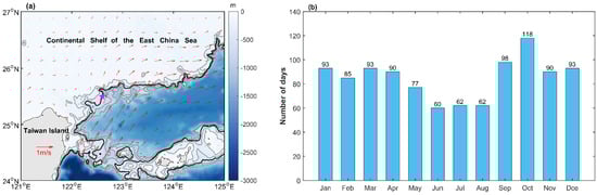
Figure 1.
(a) Bathymetry (color) off northeastern Taiwan and average location of the mooring (magenta star). The thin gray lines indicate the 200 m, 400 m, 800 m, and 1000 m isobaths, and the thick black line indicates the 600 m isobaths. The red arrows denote the mean sea surface geostrophic currents during the whole observation period. (b) Histogram of the number of observation days in each month.

Table 1.
Detailed information on the three mooring observations (OP1–OP3) after linear interpolation.
2.2. Satellite Altimeter Data
The gridded satellite altimeter data used in this study integrate multiple satellites (Jason-3, Sentinel-3A, HY-2A, SARAL/AltiKa, Cryosat-2, Jason-2, Jason-1, TOPEX/Poseidon, ENVISAT, GFO and ERS1/2) with a temporal resolution of 1 d and a spatial resolution of 1/4°. Archiving, Validation, and Interpretation of Satellite Oceanographic (AVISO) data during the three periods of mooring observations were used to provide geostrophic velocities in the research region. Satellite altimeter data are now available from the Copernicus Marine Environment Monitoring Service (CMEMS). The version of the datasets used in this study is “Global Ocean Gridded L4 Sea Surface Heights and Derived Variables Reprocessed (1993-ongoing)”, which can be obtained from https://resources.marine.copernicus.eu/product-deail/SEALEVEL_GLO_PHY_L4_MY_0 162 08_047/DATA-ACCESS and was accessed on 18 January 2022.
2.3. Other Data
In this study, the bathymetry of the region around the mooring is obtained from ETOPO1 Global Relief Model, as shown in Figure 1a, which is a 1 arc–minute global relief model of Earth’s surface that integrates land topography and ocean bathymetry and can be downloaded from https://www.ngdc.noaa.gov/mgg/global/global.html; accessed on 16 June 2020. In addition, the daily HYCOM + NCODA Global 1/12° analysis was used as a substitute for the hydrography to calculate the buoyancy frequency, which was downloaded from the Asia-Pacific Data-Research Center (APDRC, http://apdrc.soest.hawaii.edu/data, accessed on 22 November 2021). The Niño 3.4 index was obtained from National Climate Center of China Meteorological Administration (NCC, https://cmdp.ncc-cma.net/pred/cn_enso.php?product=cn_enso_nino_indices, accessed on 7 April 2022) to evaluate the El Niño and La Niña events.
2.4. Methods
In order to investigate the characteristics of shear caused by different motions, the ocean shear [12] was calculated as follows:
where u () and v () are the zonal and meridional components of the currents (shear), respectively. In addition, to evaluate the intensities of different motions, the kinetic energy (KE) density was calculated as follows:
where = 1024 kg⁄m3 is the reference water density, and u and v are the zonal and meridional currents of different motions, respectively.
Based on the in situ observed currents after linear interpolation, sub-inertial currents (SICs); near-inertial waves (NIWs); and diurnal (D1), semidiurnal (D2), and tridiurnal (D3) internal tides (ITs) were obtained using a fourth-order Butterworth filter. The SICs contain both eddies and background currents, mainly the Kuroshio in this study. Furthermore, the filter was carried out twice in the forward and backward directions to eliminate the phase shift. In this study, the same cutoff frequencies were used for OP1–OP3, as the results of nearly the same mooring deployment location. Therefore, according to the depth-averaged power spectral of the horizontal currents in OP3 (Figure 2a) and a previous study [24], the cutoff frequencies of 0–0.40 f, 0.80–1.05 f, 1.05–1.45 f, 2.05–2.45 f, and 3.15–3.55 f were selected for SICs; NIWs; and D1, D2, and D3 ITs, respectively. The local inertial frequency (f) is approximately 0.036 cycles per hour (cph). Thereafter, the shear caused by SICs; NIWs; and D1, D2, and D3 ITs was calculated by Equation (1) based on the bandpass filtered currents, and the total shear was calculated according to the linearly interpolated currents. Moreover, the intensities of SICs, NIWs, and ITs were calculated according to Equation (2).
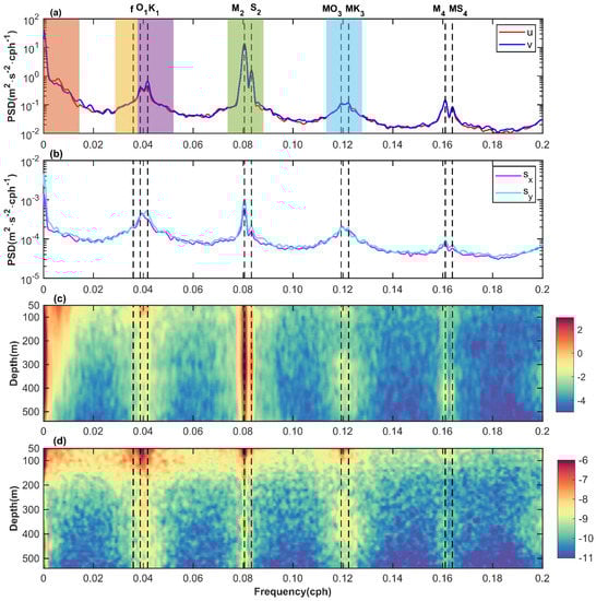
Figure 2.
Depth-averaged power spectra of the currents (a) and total shear (b) in OP3, and the red (magenta) and blue (cyan) lines indicate the zonal and meridional components of the currents (total shear), respectively. The orange, yellow, purple, green, and light blue shadings denote cutoff frequencies for SICs; NIWs; and D1, D2, and D3 ITs in (a), respectively. Depth–frequency plot of the log of power spectral densities (shading) of the zonal currents (c) and total shear (d). The black vertical dashed lines denote the local inertial frequency (f) and dominant tidal frequencies O1, K1, M2 and S2 as well as their harmonic frequencies MO3, MK3, M4 and MS4.
In this study, the coherent and incoherent components of ITs (D1, D2, and D3) were extracted following previous studies [12,35,39,40] to examine the shear caused by those motions according to Equation (1). First, the coherent ITs were obtained by tidal harmonic analysis [41] referring to Yang et al. [36]. Thereafter, the incoherent ITs were calculated by subtracting the coherent ITs from the band-pass filtered ITs. Moreover, the modal decomposition was conducted on the coherent and incoherent ITs to investigate their modal content. The coherent and incoherent components of ITs are expressed as follows [42]:
where and denote the zonal and meridional components of the coherent and incoherent ITs, respectively, and and are the modal components of and , respectively, with respect to mode n (n = 0, 1, …, m; n = 0 for the barotropic mode and n > 0 for baroclinic modes), which can be computed by the least-squares modal fitting [1,43]. Furthermore, represents the vertical structures of modes for the horizontal velocity calculated as follows:
where are the eigenfunctions of the eigenvalue problem for eigenspeed :
where H is the water depth, N is the buoyancy frequency calculated based on HYCOM analysis data, and = 1024 kg/m3 is the reference water density.
3. Results
3.1. Spectral Analysis
In order to examine the dominant signals at the local current field and the intensities of shear caused by different motions, the power spectra of the currents and shear were calculated. Figure 2a,b show the depth-averaged power spectra of the currents and total shear in OP3 as an example, respectively. At the same time, the power spectra of the zonal component of interpolated currents and total shear in OP3 as a function of frequency and depth are displayed in Figure 2c,d, respectively. From the power spectra of the currents (Figure 2a,c), noteworthy spectral densities can be found at the signals of SICs; NIWs; and D1, D2, D3, and quarter-diurnal (D4) ITs. The larger spectral peaks that occurred near the 0 frequency and at the M2 frequency are much larger than those at other frequencies by more than 10 times, which indicates that the current field here is dominated by low-frequency currents and M2 internal tides. Moreover, prominent spectral densities appear around the frequencies of 0 and M2 throughout the observation depth layer. For the local internal wave field, the D2 ITs overwhelm other internal wave signals, which is consistent with previous studies [23,29,32,36]. The spectral densities of D1 ITs are only less than those of the D2 ITs. In addition, the NIWs and the D3 and D4 ITs have comparable spectral densities. However, the NIWs and the D1, D3, and D4 ITs exhibit different intensities from the observation surface to the bottom layer. Strong NIWs and D1 ITs signals appear above 150 m, and the D3 ITs signals improve from 250 m to 400 m. In addition to this, from 370 m to 460 m, the spectral densities of D4 ITs are most notable. At the mooring, nonlinear interactions between internal waves occurred because of spectral peaks that appeared at the MO3, MK3, M4, and MS4 frequencies. Although the near-inertial frequency shows the characteristic of broadband, when significant near-inertial waves occur at the mooring, such as that induced by the passage of a typhoon, a spectral peak will appear near the local inertial frequency (f) [23].
Compared with the current spectra, the power spectra of shear display different characteristics. As shown in Figure 2b,d, the SICs dominate the shear spectra, but the shear signal caused by SICs is weak from 200 m to 350 m. Although the D2 ITs are much stronger than the D1 ITs, there are approximately the same spectral density intensities in the frequency bands of D1 and D2 ITs in the shear spectra. Moreover, the spectral densities of D4 ITs are much smaller than those of NIWs and D3 ITs, whereas the latter two have comparable spectral densities. Considering that the intensities of the NIWs and the D3 and D4 ITs are equivalent, the reason for that phenomenon may be that the normal modes dominating the D4 ITs are lower than those dominating the NIWs and D3 ITs. Hence, in this study, the SICs; NIWs; and D1, D2, and D3 ITs were selected to investigate the features of ocean shear. In addition, the shear intensities of the SICs; NIWs; and D1, D2, and D3 ITs are most remarkable in the upper 200 m, as shown in Figure 2d. There are similar results in OP1 and OP2, which are not shown here.
3.2. Total Shear Characteristics
The vertical pattern and seasonal features of the total shear calculated based on the linearly interpolated currents were first investigated. Figure 3 illustrates the time series of profiling low-pass filtered total shear in OP1–OP3. It is obvious that the total shear exhibits intensified in the upper ocean with significant high total shear essentially concentrated above 200 m. In addition, there is also relatively strong total shear in the 200 m to 400 m depth layer. However, it displays a time-intermittent and small shear value, which is different from total shear in the upper layer. For instance, from January 2020 to April 2020, stronger total shear occurs (Figure 3c), whereas, from mid-September 2017 to October, there is weaker total shear at depths of 200 m to 400 m (Figure 3a). The various temporal variations of the total shear are also presented in Figure 3. As shown in Figure 3b, in OP2, the high total shear in the upper layer is significantly larger than that in OP1 and OP3 during the same period over different years, suggesting that the total shear has an interannual variation, which might be the result of the influence of the background currents of the Kuroshio. The intra-seasonal variability of the total shear is clearly exhibited in OP1–OP3. Furthermore, remarkable seasonal variation exists in the total shear, which is one of the focuses of this study.
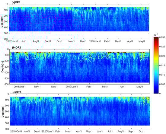
Figure 3.
Depth–time map of 36 h low-pass filtered total shear (a) for OP1, (b) for OP2, and (c) for OP3.
Although the mooring observation periods in OP1–OP3 are different, as listed in Table 1, each month has at least 60 observation days, which is shown in Figure 1b Therefore, the time average of the shear in different seasons is sufficient to reflect its seasonal characteristics. Figure 4 presents the vertical structures of the seasonally mean total shear and its corresponding standard deviations for the entire observation period (OP1–OP3). It is clear that the seasonal mean total shear presents a surface-intensified characteristic, which is similar to the shear in the northern South China Sea [12]. The shear basically decreases with depth in the upper 200 m, except in winter, whereas the shear below 200 m exhibits a trend of increasing first and then decreases with depth with the extreme values occurring at approximately 350 m. In addition, the seasonal mean total shear shows different intensities at different depth layers, and the total shear strength varies with depth most noticeably in summer and winter. In summer, the total shear is smaller than that in other seasons from 100 m to 400 m. Winter has the weakest total shear in the upper 100 m; however, it appears, roughly, to be the strongest total shear below 150 m. The total shear in autumn seems to be larger than that in other seasons at shallower depths than 150 m. The vertical profile of the total shear in spring is closest to that of the whole observation period’s averaged total shear in all seasons. Moreover, a similar vertical pattern is displayed in the standard deviations (Figure 4b). The standard deviation for all seasons varies only slightly with increasing depths below 200 m, ranging from 0.002 to 0.004 s−1, which indicates that the total shear changes sharply above 200 m but is relatively stable below 200 m depth.
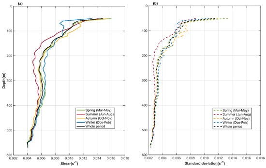
Figure 4.
Vertical profiles of seasonal mean total shear (a) and its corresponding standard deviations (b). The black solid and dashed lines indicate the whole observation period.
Figure 5 illustrates the climatological monthly depth-averaged total shear. There exists an evident seasonal variation of the depth-averaged (50–570 m) total shear (Figure 5a). Higher total shear occurs in late autumn to mid-spring (October to April), and lower total shear appears in summer (June to August). The largest and smallest total shear are found in March and July, respectively. The Kuroshio mainstream that meandered and intruded into the ECS northeast of Taiwan might be related to the seasonal variation of the total shear, since the Kuroshio mainstream moves seaward (shoreward) in summer (winter), with the eastern (western) invasion dominating [14,15,44], and the mooring station will not be (will be) affected by it. Furthermore, the vertical distributions of the mean total shear for the four seasons demonstrate different trends in their intensities over and under 200 m, as analyzed above. Therefore, the depth-averaged total shear values from 50 m to 200 m and 210 m to 570 m are also presented in Figure 5b,c, respectively. The result clearly reveals that they have different seasonal variation characteristics. For the former, stronger total shear occurs in spring (March to May) and autumn (September to November), and summer and winter (December to February) have weaker total shear, suggesting a semi-annual cycle. However, for the latter, the total shear displays a trend of decreasing first and then increasing, with the maximum and minimum values being found in January and July, respectively. The smallest total shear appearing in summer is a common point for both.
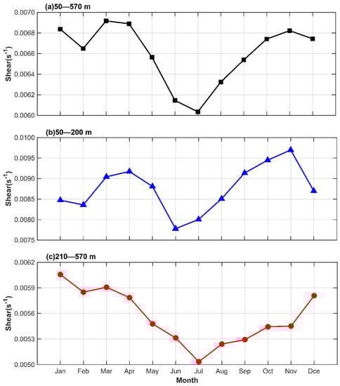
Figure 5.
Seasonal evolutions of the depth-averaged total shear. (a–c) represent total shear averaged over 50–570 m, 50–200 m, and 210–570 m, respectively.
3.3. Seasonal Variability of Shear Caused by Different Motions
In this section, the seasonal variability and relative importance of shear caused by SICs; NIWs; and D1, D2, and D3 ITs are investigated, in frequency bands within which the significant shear spectral densities are noted, as shown in Figure 2d. As with the total shear, the shear caused by those motions is divided into two depth layers for depth averaging (50 m to 200 m and 210 m to 570 m). The seasonal evolutions of the depth-averaged shear caused by SICs, NIWs, and ITs are plotted in Figure 6. As a comparison, the kinetic energy densities of those motions are also presented in Figure 7. At the same time, the proportions of shear (kinetic energy densities) caused by (of) those motions to the sum of the shear (kinetic energy densities) are calculated to further quantify the seasonality of the different shear and estimate their relative importance, the details of which are listed in Table 2. Figure 6 clearly shows that the shear averaged over the different depth layers has different seasonal variations, which is consistent with the results of the total shear. On the one hand, from the seasonal trends of the different shear, first, for the shear averaged at depths of 50 m to 200 m, the shear caused by SICs and D2 ITs exhibits a similar trend to the total shear, being stronger in spring and autumn and weakest in summer. However, the shear caused by D1 and D3 ITs is stronger in summer and autumn, and the most energetic shear caused by them appears in November and August, respectively. NIWs cause stronger shear in October and November, and a comparable shear is found during other months. For the shear averaged at depths of 210 m to 570 m, the shear in different frequency bands shows a similar seasonal trend, which is in agreement with the total shear averaged over the same depth layer. That is, stronger shear occurs in spring and winter, with weaker shear in summer and autumn. On the other hand, from the percentage of different shear in the four seasons, for the depth-averaged shear above 200 m, the SICs and D3 ITs induce strongest and weakest shear in all seasons except summer, of which the proportions in the sum of different shear are 27.8–33.3% and 11.4–13.9%, respectively. In summer, the shear caused by D1 ITs is strongest and is followed by SICs. D2 and D3 ITs cause a comparable shear that is a little stronger than that caused by NIWs. In the other three seasons, the shear in frequency bands of NIWs and D1 and D2 ITs has various intensities. However, the shear induced by NIWs accounts for 14.4–16.0% of the sum of different shear, which is weaker than that induced by D1 and D2 ITs, whose percentages range from 19.7% to 22.2%. Regarding the depth-averaged shear below 200 m, the shear intensity of NIWs is the weakest during all seasons. Although the relative shear intensities of SICs and ITs vary over all seasons, they are comparable with the proportions of 19.5–23.1%. In addition, it can be noted that the proportion of shear caused by D3 ITs is significantly improved relative to the upper depth, whereas for SICs, the change is reversed.
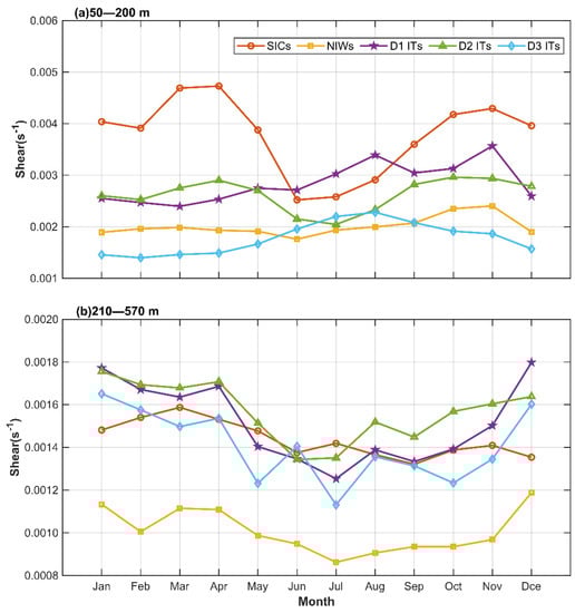
Figure 6.
Seasonal evolutions of the depth-averaged shear caused by SICs (orange), NIWs (yellow) and D1 (purple), D2 (green), and D3 (light blue) ITs. (a,b) represent the shear averaged over 50–200 m and 210–570 m, respectively.
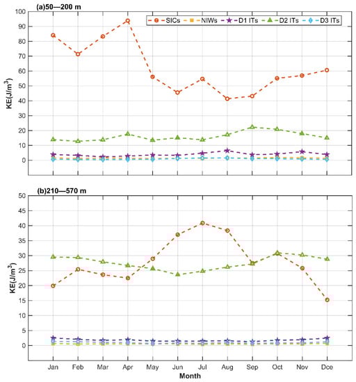
Figure 7.
Seasonal evolutions of the depth-averaged kinetic energy densities caused by SICs (orange), NIWs (yellow) and D1 (purple), D2 (green), and D3 (light blue) ITs. (a,b) represent the shear averaged over 50–200 m and 210–570 m, respectively.
Table 2.
The seasonal depth-averaged shear (kinetic energy densities) caused by (of) SICs, NIWs, and Its, as well as their proportions (in brackets) in the sum of the shear (kinetic energy densities) in the different average depth layers.
As shown in Figure 7 and Table 2, the SICs and D2 ITs dominate the motions from the ocean surface to the bottom over all seasons, consistent with the results of the power spectra of the zonal currents displayed in Figure 2c. However, their proportions vary substantially with depth layers and seasons. Under the influence of the Kuroshio, SICs are the most energetic at an average depth of 50–200 m, of which the kinetic energy density occupies 65.1–79.1%, which is 2–5 times larger than that of D2 ITs. At an average depth of 210–570 m, D2 ITs are slightly stronger than SICs in all seasons except summer, in which SICs are highest in terms of the strengthening of the continental slope countercurrents off northeastern Taiwan in summer [45,46]. For NIWs and D1 and D3 ITs, it can be clearly seen that they are weak in the whole depth layer, the sum of which accounts for less than 11% of the sum of the kinetic energy density in all seasons. However, it is worth noting that the sum of the shear caused by them takes up 45.5–58.8% of the total. This indicates that NIWs and D1 and D3 ITs have a higher efficiency or stronger ability to cause shear compared to SICs and D2 ITs. Therefore, in order to evaluate this efficiency or ability quantitatively, we define the shear efficiency (SE), which is calculated by the following equation:
where is the proportion of shear caused by different motions to the sum of the shear and is the same as but for kinetic energy densities. The shear efficiencies of SIWs, NIWs, and ITs are listed in Table 3. The results show that the shear efficiency values of NIWs and D1 and D3 ITs are remarkably larger than those of SICs and D2 ITs, which are less than 0.6 and 1.4, respectively. Moreover, the shear efficiencies of D1 ITs are smaller than those of NIWs and D3 ITs. However, for NIWs and D3 ITs, the shear efficiencies of the former are smaller than those of the latter at an average depth layer of 50 to 200 m, while it is reversed at depths averaging 210 to 570 m.
Table 3.
The seasonal shear efficiencies of SICs, NIWs, and ITs in the different average depth layers.
3.4. Vertical Structure of Shear Caused by Different Motions
The vertical profiles of the seasonal mean shear caused by SICs; NIWs; and D1, D2, and D3 ITs are displayed in Figure 8 for examination of the vertical pattern of the shear. Similar to the total shear (Figure 4a), in general, the shear in different frequency bands shows a remarkable surface-enhanced structure and a trend of rapid decrease, then slightly increases and slowly decreases with depth, but with little differences between seasons. In spring and summer, the different shear presents a similar trend with depth. At the same time, it exhibits a similar vertical pattern in autumn and winter. However, the various intensities of the different shear values are found in different seasons, details of which appear in Section 3.3. For example, in summer, the shear caused by D1 ITs decreases from 0.0063 s−1 at 50 m to 0.0012 s−1 at 220 m, that is, a reduction of 81.0% within 170 m. It increases from 0.0012 s−1 at 220 m to 0.0015 s−1 at 360 m. In winter, the vertical variation of shear is somewhat different from that in summer. For instance, the D1 ITs cause the shear to decrease quickly from 50 m to 70 m, then increase, and finally decrease with depth.
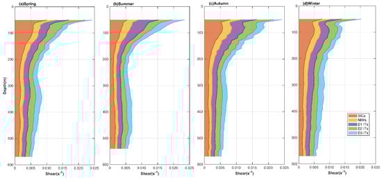
Figure 8.
Vertical structures of the shear caused by motions in different frequency bands (stacked areas) in four seasons. (a–d) for spring, summer, autumn, and winter, respectively.
3.5. Shear Caused by Coherent and Incoherent ITs
First, the tidal-current ellipses of the major D1, D2, and D3 constituents are calculated over the OP3 via the harmonic analysis to examine the vertical structural characteristics of the major baroclinic tidal currents, as shown in Figure 9, in which the red (blue) ellipses denote clockwise (counterclockwise) rotation. Note that the horizontal axes vary with subfigures. In addition, the harmonic analysis results are mainly coherent baroclinic tides. The results indicate that the M2 and S2 ITs dominated the baroclinic tidal currents from the ocean surface to the bottom, especially the M2 ITs, which is consistent with the results of the spectral analysis. The strong M2 and S2 ITs occur roughly at 200 m to 450 m water depth with the weakest at the surface and bottom. Moreover, the MK3 and MO3 ITs have a similar vertical variation in intensity, whereas the K1 and O1 ITs are basically stronger at a shallow depth of 200 m. Additionally, the M2 and S2 ITs increases first in the clockwise rotation with the depth and then counterclockwise rotation, at a turning depth of approximately 450 m. In addition, the K1, O1, and MK3 ITs rotate clockwise at approximately 350 m depth or more, then the rotation directions of those vary repeatedly with depth. However, the MO3 ITs rotate mainly clockwise with a counterclockwise rotation from 200 m to 250 m.
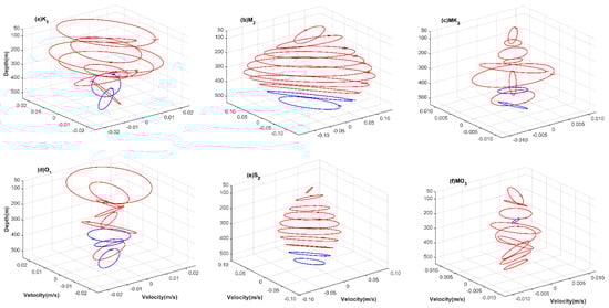
Figure 9.
Tidal current ellipses of the major baroclinic tidal constituents of ITs (D1, D2, and D3) over the OP3. (a–f) denote the K1, M2, MK3, O1, S2, and MO3 tidal constituent, respectively. The red ellipses denote clockwise rotation, and the blue ellipses denote counterclockwise rotation.
Since the coherent and incoherent components of the ITs (D1, D2, and D3) are an important feature of the internal tides [34,35,47,48], the shear they cause is investigated in this section. The kinetic energy densities of the coherent and incoherent components of the ITs are also calculated for comparison. Figure 10 shows the vertical variations of the seasonal mean shear and kinetic energy densities of the coherent and incoherent components of D1 ITs. Figure 11 and Figure 12 are the same as Figure 10, but for D2 and D3 ITs, respectively. The results clearly illustrate that the shear caused by the coherent and incoherent components of the ITs displays a surface-intensified pattern, which is consistent with the results above. However, the shear presents different seasonal structures and intensities among the ITs. The shear caused by the coherent and incoherent components of the D1 ITs shows a similar vertical trend in each season, decreasing with increasing depth. However, for the D2 ITs, the different shear vertical patterns are found between the coherent and incoherent components. Overall, the shear caused by the coherent component first decreases rapidly from 50 m to approximately 300 m and then shows a trend of increasing and then decreasing with depth, whereas the incoherent component causes the shear to decrease with depth. It is interesting that they show little seasonal change. For the D3 ITs, the coherent component shares a similar shear vertical structure to the incoherent component in each season. This feature is in agreement with the D1 ITs, whereas the vertical variation is different. Overall, the shear has a trend of first decreasing then increasing and finally decreasing with depth. However, there are various turning depths in the four seasons. In spring, summer, and autumn, the first turning depth is approximately 200 m, and the other turning depths are approximately 350 m and 400 m. In winter, the two turning depths are approximately 70 m and 300 m, respectively.
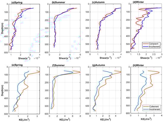
Figure 10.
Vertical structures of the seasonal mean shear and kinetic energy densities of the coherent and incoherent components of D1 ITs. (a–d) indicate the shear in spring, summer, autumn, and winter, respectively, and (e–h) denote the kinetic energy densities in spring, summer, autumn, and winter, respectively.
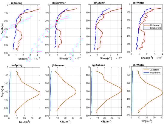
Figure 11.
Vertical structures of the seasonal mean shear and kinetic energy densities of the coherent and incoherent components of D2 ITs. (a–d) indicate the shear in spring, summer, autumn, and winter, respectively, and (e–h) denote the kinetic energy densities in spring, summer, autumn, and winter, respectively.
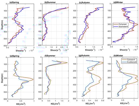
Figure 12.
Vertical structures of the seasonal mean shear and kinetic energy densities of the coherent and incoherent components of D3 ITs. (a–d) indicate the shear in spring, summer, autumn, and winter, respectively, and (e–h) denote the kinetic energy densities in spring, summer, autumn, and winter, respectively.
Although there are various intensities of the shear in the four seasons, the shear caused by the incoherent component of D1 and D3 ITs is a little stronger than, or comparable to, that caused by the coherent component. However, the kinetic energy densities of the incoherent component of D1 and D3 ITs are smaller than or comparable to those of the coherent component, as listed in Table 4, which shows the time–depth averaged shear and kinetic energy densities of the coherent and incoherent components of ITs in four seasons. However, the shear caused by the incoherent component of D2 ITs is 0.6–0.7 times of that caused by the coherent component. It is worth noting that the kinetic energy densities of the incoherent component of D2 ITs are only 0.04–0.05 times those of the coherent component. The appearance of the above results may be due to the incoherent component having a larger vertical wavenumber compared to the coherent component.
Table 4.
Time–depth averaged shear and kinetic energy densities of the coherent and incoherent components of D1, D2, and D3 ITs in four seasons.
4. Discussion
Although total shear has different seasonal variations in the upper and lower layers, the seasonal variation of the total shear averaged across the depth is generally consistent with that of the total shear in the upper layer (Figure 5) due to the presence of remarkably higher shear above 200 m (Figure 3). The total shear appears weakest in summer and stronger in other seasons, as described above. The dominant shear caused by SICs in the upper layer indicates that this seasonal variation is associated with the background currents of the Kuroshio, of which the intrusion into the ECS occurs mainly in the upper 200 m presented by Yang et al. [36]. Figure 13 shows the climatological monthly geostrophic velocities (GV) off northeastern Taiwan and the location of the mooring, which obviously displays the seasonality of the Kuroshio mainstream meandering and its intrusion into the continental shelf of the ECS. At the same time, the Kuroshio axis position (KAP) is calculated based on Equation (7) in order to quantitatively evaluate the Kuroshio mainstream meandering [49].
here, denotes the normal sea surface geostrophic velocity of section Q (the green dashed line in Figure 13) derived from the satellite altimeter data; x denotes distance from the western integral limits of section Q; and and are the western and eastern integral limits, respectively. The climatological monthly KAP is shown in Figure 14, which denotes the distance from the easternmost side of section Q. The results suggest that the KAP moves offshore and is closest to the easternmost side of section Q in summer, which corresponds to the weak Kuroshio intrusion into the western part of the southwestern continental slope of the ECS, which is consistent with the findings of Liu et al. [14,15]. At this time, the mooring station is weakly affected by Kuroshio. However, the above characteristics are reversed in other months, especially from November to April. In addition, the variation of climatological monthly KAP is highly similar to that of the total shear and shear induced by SICs. Their linear correlation coefficients reach 0.82 (p < 0.05) and 0.82 (p < 0.05), respectively. Therefore, the meander of the Kuroshio mainstream and the Kuroshio intrusion affect the seasonal variation of total shear mainly by influencing the shear caused by SICs. When the Kuroshio mainstream shifts to onshore, the Kuroshio strongly intrudes into the shelf in the western part of the southwestern continental slope of the ECS, which strengthens the shear at the observation station; then the local ocean mixing is enhanced.
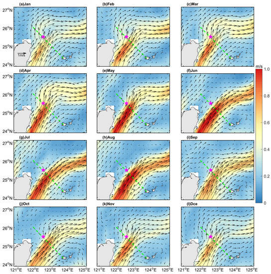
Figure 13.
The climatological monthly sea surface geostrophic velocities (black arrows) and the corresponding geostrophic velocity amplitudes (color) off northeastern Taiwan over the whole observation periods based on the satellite altimeter data. The magenta pentagrams denote average location of the mooring; the green dashed lines denote the section Q to calculate the Kuroshio axis position, (a–l) January–December.
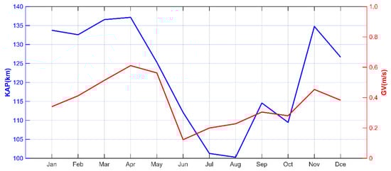
Figure 14.
The climatological monthly Kuroshio axis position (blue solid line) and the climatological monthly geostrophic velocity amplitudes (red solid line) at the mooring.
For the internal wave field at the observation station, the percentages of the KE of NIWs and D1 and D3 ITs range from 0.8% to 2.1%, 2.3% to 6.8%, and 0.6% to 2.4% of the sum KE over the four seasons, respectively. However, the shear caused by them accounts for 13.9–16.0%, 19.7–25.2%, and 11.4–21.0% of the total shear, respectively. In contrast, D2 ITs share 15.2–54.4% of the sum KE and make a contribution to 18.5–23.1% of the sum shear. This indicates that the SEs of NIWs, D1, and D3 ITs are significantly higher than that of D2 ITs, as listed in Table 3. Figure 15 illustrates the time–depth maps of the zonal currents of NIWs and D1, D2, and D3 ITs. January in 2018, 2019, and 2020 are selected as representatives to qualitatively analyze their modal characteristics. It is obvious that the NIWs and D1 and D3 ITs exhibit complicated vertical patterns, showing multiple 180° phase transitions in the vertical direction, whereas the opposite phase currents in the surface and bottom layers are predominantly found in the D2 ITs. Therefore, the NIWs and D1 and D3 ITs are dominated by higher baroclinic modes with large vertical wavenumbers, while the predominant mode of the D2 ITs is the first baroclinic mode exhibiting low wavenumber signals, which results in a greater SE of NIWs and D1 and D3 ITs than that of D2 ITs. These results reveal that motions with large vertical wavenumbers should be taken into account when studying ocean-mixing characteristics and developing a parameterization scheme for turbulent mixing, even if they have a small kinetic energy share.
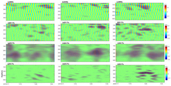
Figure 15.
Time–depth plots of the zonal currents of NIWs (a–c) and D1 (d–f), D2 (g–i), and D3 (j–l) ITs in January 2018 (a,d,g,j), 2019 (b,e,h,k), and 2020 (c,f,i,l) at the mooring.
By comparing the shear caused by coherent and incoherent ITs with the KE, as shown in Section 3.5, the SE of incoherent ITs is relatively strong compared to that of coherent ITs. Given that both the coherent and incoherent components have a complex vertical structure for D1 and D3 ITs, it is difficult to determine their modal content by qualitative methods such as those shown above. Hence, modal decomposition is used for the coherent and incoherent components. Meanwhile, the KE of each mode is calculated to quantitatively evaluate their contributions. Figure 16 shows the time series of the depth-averaged coherent and incoherent internal tidal KE of modes in OP3, which represent the whole observation period. In this study, it was appropriate to adopt the first seven baroclinic modes in the modal decomposition for D1 and D3 ITs and the first five baroclinic modes for D2 ITs, which could reflect the KE of the ITs to a greater extent without causing overfitting. Moreover, the proportions of KE in modes of the coherent and incoherent components of ITs are listed in Table 5. The modal decomposition results indicate that the sum of the third to last modes of coherent components of the D1, D2, and D3 ITs accounts for 60.4%, 25.8%, and 65.0%, respectively, while it increases to 71.4%, 33.2%, and 67.1% for incoherent components, respectively. Thus, the high modes make up a larger proportion of the incoherent component in comparison to the coherent component, agreeing with the results of previous studies in the South China Sea [12,47,48], which explains the greater SE of the incoherent ITs. Consequently, the generation, propagation, and dissipation of the incoherent ITs should be given more attention, which provides an important contribution to ocean mixing as well as affecting the local parameterization of turbulent mixing.
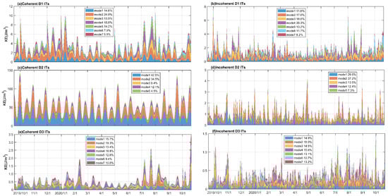
Figure 16.
Time series of the depth-averaged modal KE (stacked areas) of coherent (a,c,e) and incoherent (b,d,f) components of the D1 (a,b), D2 (c,d), and D3 (e,f) ITs in OP3 at the mooring. The dark blue, orange, yellow, purple, green, light blue, and dark red indicate the first, second, third, fourth, fifth, sixth, and seventh baroclinic modes, respectively. Note that the modal KE has been low-pass filtered for 48 h to remove oscillations at its own frequency.
Table 5.
The proportions of kinetic energy densities in modes of the coherent and incoherent (in brackets) components of D1, D2, and D3 ITs.
In addition to the significant seasonal variability of the total shear, in which interannual variation is also found, as shown in Figure 3, the total shear in the upper layer in OP2 is significantly higher than that in OP1 and OP3 for the same period of different years. Figure 17a plots the 3-month running-averaged Niño 3.4 index and total shear average above 100 m. Here, an El Niño or La Niña event is identified if the 3-month running-average of the Niño 3.4 index is more than 0.5 °C (El Niño) or less than −0.5 °C (La Niña) for at least 5 consecutive months. There was one El Niño event (September 2018 to June 2019) and two La Niña events (October 2017 to March 2018 and August 2020 to March 2021) that occurred during the observation period. The observation period of OP2 from 12 September 2018 to 18 May 2019 exactly coincided with the El Niño event, which suggests that the ENSO is related to the interannual variation of the total shear in the upper layer. Furthermore, Figure 17b, which shows that the monthly shear caused by SICs, NIWs, and ITs averaged above 100 m, reveals that the significant increase in total shear is due to the enhancement of the shear induced by SICs. Therefore, it is reasonable to speculate that El Niño influenced the total shear by affecting the background currents, which, in this case, was the Kuroshio. However, the observation period was only close to 3 years, which is insufficient to study the exact relationship between ENSO and shear. Thus, it is necessary to accumulate longer-term observational data or use numerical models to further study the effect of ENSO on the shear on the southwestern continental slope of the ECS.
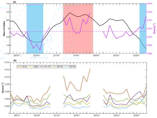
Figure 17.
(a) Time series of the monthly 3-month running-averaged Niño 3.4 index (black solid line) and the total shear averaged above 100 m (magenta solid line); the light-red and light-blue shadings denote the El Niño event and La Niña event, respectively. The magenta dashed line indicates the mean total shear averaged above 100 m. (b) Time series of the monthly shear caused by SICs, NIWs, and ITs averaged above 100 m.
5. Conclusions
Based on nearly three years of mooring observation data, we investigated the vertical structures and seasonal variation of the shear on the southwestern continental slope of the ECS. The power spectra of the currents show that the significant spectral densities appear in the frequency bands of SICs; NIWs; and D1, D2, D3, and D4 ITs, especially in the SICs and D2 ITs which have the most energetic spectral signals from the surface to the bottom of the ocean. However, a different pattern is presented in the shear spectra, which exhibit large spectral densities concentrated in the upper 200 m and a weak shear intensity in D4 ITs. The vertical profiles of the total shear and the shear caused by different motions indicate that the shear shows a remarkable surface-intensified pattern and a basic trend of rapidly decreasing, then slightly increasing, and then slowly decreasing with depth. Notable seasonal characteristics were found in the shear but with differences between the upper (50–200 m averaged) and lower (210–570 m averaged) layers. In the upper layer, the shear caused by SICs and D2 ITs shows a similar trend to the total shear, being stronger in spring and autumn and weakest in summer. However, the shear caused by D1 and D3 ITs is stronger in summer and autumn, with the largest shear induced in November and August, respectively, and the NIWs induce stronger shear in October and November. Moreover, the SICs largely dominate the local shear field with 27.8–33.3% of the sum shear, and the D3 ITs cause the smallest shear, with 11.4–13.9% of the sum shear. In the lower layer, the shear induced by different motions has similar seasonal trends and is consistent with the total shear, i.e., the stronger shear occurs in spring and winter, while the weaker shear occurs in summer and autumn. In addition, the shear caused by the NIWs is the weakest, sharing 13.9–15.9% of the sum shear, while the shear induced by SICs and ITs (D1, D2 and D3) is comparable, accounting for 19.5–23.1% of the sum shear.
Our analysis, performed by combining the KE and shear caused by SICs, NIWs, and ITs (D1, D2, and D3), reveals that the SE of SICs and D2 ITs is obviously less than that of NIWs, D1, and D3 ITs, at 0.3–1.4 and 3.7–19.0, respectively. For the internal wave field, the NIWs and D1 and D3 ITs display signs of high baroclinic modes with large vertical wavenumbers, while the D2 ITs are dominated by the first baroclinic mode, which results in a larger SE of the NIWs and the D1 and D3 ITs than that of the D2 ITs. Furthermore, the shear caused by the coherent and incoherent components of ITs (D1, D2, and D3) was examined in this study. The results indicate that the SE of incoherent ITs is relatively strong compared to that of coherent ITs because of a larger proportion of high baroclinic modes in the incoherent component compared to the coherent component based on modal decomposition. Finally, the total shear in the upper layer has remarkable seasonal variation, as well as interannual variation, which may be related to ENSO needing to be further investigated with longer observation data.
Author Contributions
Conceptualization, Y.H. and Z.O.; methodology, Z.O.; formal analysis, Z.O.; data curation, Z.L.; writing—original draft preparation, Z.O.; writing—review and editing, Z.O. and Z.L; supervision, Z.L.; funding acquisition, Y.H. and Z.L. All authors have read and agreed to the published version of the manuscript.
Funding
This research was funded by the National Natural Science Foundation of China, grant numbers 42076002, 41776020, and 41630967.
Institutional Review Board Statement
Not applicable.
Informed Consent Statement
Not applicable.
Data Availability Statement
Data are available in a publicly accessible repository that does not issue DOIs. The satellite altimeter data were obtained from the Copernicus Marine Environment Monitoring Service (CMEMS, https://resources.marine.copernicus.eu/product-deail/SEALEVEL_GLO_PHY_L4_MY_008_047/DATA-ACCESS, accessed on 18 January 2022). The daily HYCOM + NCODA Global Analysis data are available at http://apdrc.soest.hawaii.edu/data and were accessed on 22 November 2021. The ETOPO1 Global Relief Model was downloaded from https://www.ngdc.noaa.gov/mgg/global/global.html and was accessed on 16 June 2020. The Niño 3.4 index is obtained from the National Climate Center of China Meteorological Administration (NCC, https://cmdp.ncc-cma.net/pred/cn_enso.php?product=cn_enso_nino_indices, accessed on 7 April 2022).
Acknowledgments
The acquisition of mooring data was supported by the NSFC Open Research Cruise China (Cruises Nos. NORC2017-02, NORC2018-01, NORC2019-01 and NORC2020-02), funded by the Ship-time Sharing Project of NSFC, China. This cruise was conducted onboard R/V “Xiang Yang Hong 18” by the First Institute of Oceanography, State Oceanic Administration, China. We also thank the associate editor and the anonymous reviewers for their useful feedback that improved this paper.
Conflicts of Interest
The authors declare no conflict of interest. The funders had no role in the design of the study; in the collection, analyses, or interpretation of data; in the writing of the manuscript, or in the decision to publish the results.
References
- Alford, M.H. Redistribution of energy available for ocean mixing by long-range propagation of internal waves. Nature 2003, 423, 159–162. [Google Scholar] [CrossRef]
- Nikurashin, M.; Ferrari, R. Overturning circulation driven by breaking internal waves in the deep ocean. Geophys. Res. Lett. 2013, 40, 3133–3137. [Google Scholar] [CrossRef]
- Kunze, E. The internal-wave-driven meridional overturning circulation. J. Phys. Oceanogr. 2017, 47, 2673–2689. [Google Scholar] [CrossRef]
- MacKinnon, J.A.; Alford, M.H.; Ansong, J.K.; Arbic, B.K.; Barna, A.; Briegleb, B.P.; Bryan, F.O.; Buijsman, M.C.; Chassignet, E.P.; Danabasoglu, G.; et al. Climate process team on internal wave-driven ocean mixing. Bull. Am. Meteorol. Soc. 2017, 98, 2429–2454. [Google Scholar] [CrossRef]
- Whalen, C.B.; de Lavergne, C.; Naveira Garabato, A.C.; Klymak, J.M.; MacKinnon, J.A.; Sheen, K.L. Internal wave-driven mixing: Governing processes and consequences for climate. Nat. Rev. 2020, 1, 606–621. [Google Scholar] [CrossRef]
- Alford, M.H.; Mackinnon, J.A.; Pinkel, R.; Klymak, J.D. Space-time scales of shear in the North Pacific. J. Phys. Oceanogr. 2017, 47, 2455–2478. [Google Scholar] [CrossRef]
- Desaubies, Y.; Smith, W.K. Statistics of Richardson number and instability in oceanic internal waves. J. Phys. Oceanogr. 1982, 12, 1245–1259. [Google Scholar] [CrossRef]
- Klymak, J.M.; Alford, M.H.; Pinkel, R.; Lien, R.C.; Tang, T.Y. The breaking and scattering of the internal tide on a continental slope. J. Phys. Oceanogr. 2011, 41, 926–945. [Google Scholar] [CrossRef]
- Nagai, T.; Tandon, A.; Kunze, E.; Mahadevan, A. Spontaneous generation of near-inertial waves from the Kuroshio front. J. Phys. Oceanogr. 2015, 45, 2381–2406. [Google Scholar] [CrossRef]
- Yang, Q.; Zhao, W.; Liang, X.; Dong, J.; Tian, J. Elevated mixing in the periphery of mesoscale eddies in the South China Sea. J. Phys. Oceanogr. 2017, 47, 895–907. [Google Scholar] [CrossRef]
- Thorpe, S. Models of energy loss from internal waves breaking in the ocean. J. Fluid Mech. 2018, 836, 72–116. [Google Scholar] [CrossRef]
- Cao, A.Z.; Guo, Z.; Wang, S.Y.; Chen, X.; Lv, X.Q.; Song, J.B. Upper ocean shear in the northern South China Sea. J Oceanogr. 2019, 75, 525–539. [Google Scholar] [CrossRef]
- Lee, J.S.; Matsuno, T. Intrusion of Kuroshio Water onto the Continental shelf of the East China Sea. J. Oceanogr. 2007, 63, 309–325. [Google Scholar] [CrossRef]
- Liu, X.H.; Dong, C.M.; Chen, D.K.; Su, J.L. The Pattern and Variability of Winter Kuroshio Intrusion Northeast of Taiwan. J. Geophys. Res. Oceans 2014, 119, 5380–5394. [Google Scholar] [CrossRef]
- Liu, X.H.; Chen, D.K.; Dong, C.M.; He, H.L. Variation of the Kuroshio intrusion pathways Northeast of Taiwan using the Lagrangian method. Sci. China Earth Sci. 2016, 59, 268–280. [Google Scholar] [CrossRef]
- Hsueh, Y.; Chern, C.S.; Wang, J. Blocking of the Kuroshio by the continental-shelf northeast of Taiwan. J. Geophys. Res. 1993, 98, 12351–12359. [Google Scholar] [CrossRef]
- Tang, T.Y.; Tai, J.H.; Yang, Y.J. The Flow Pattern North of Taiwan and the Migration of the Kuroshio. Cont. Shelf Res. 2000, 20, 349–371. [Google Scholar] [CrossRef]
- Wu, C.R.; Lu, H.F.; Chao, S.Y. A numerical study on the formation of upwelling off northeast Taiwan. J. Geophys. Res. Oceans 2008, 113. [Google Scholar] [CrossRef]
- Qin, D.D.; Wang, J.H.; Liu, Y.; Dong, C.M. Eddy Analysis in the Eastern China Sea Using Altimetry Data. Front. Earth Sci. 2015, 9, 709–721. [Google Scholar] [CrossRef]
- Cheng, Y.H.; Ho, C.R.; Zheng, Z.W.; Lee, Y.H.; Kuo, N.J. An Algorithm for Cold Patch Detection in the Sea off Northeast Taiwan Using Multi-Sensor Data. Sensors 2009, 9, 5521–5533. [Google Scholar] [CrossRef]
- Yin, W.; Huang, D.J. Short-Term Variations in the Surface Upwelling off Northeastern Taiwan Observed via Satellite Data. J. Geophys. Res. Oceans 2019, 124, 939–954. [Google Scholar] [CrossRef]
- Park, J.H.; Lie, H.J.; Guo, B.H. Observation of semi-diurnal internal tides and near-inertial waves at the shelf break of the East China Sea. Ocean Polar Res. 2011, 33, 409–419. [Google Scholar] [CrossRef][Green Version]
- Ouyang, Z.; Liu, Z.; Sun, Y.; Yang, B.; Hou, Y. Observation of Near-Inertial Waves Induced by Typhoon Mitag (2019) on the Southwestern East China Sea Continental Slope. J. Mar. Sci. Eng. 2022, 10, 202. [Google Scholar] [CrossRef]
- Yang, B.; Hu, P.; Hou, Y. Variation and Episodes of Near-Inertial Internal Waves on the Continental Slope of the Southeastern East China Sea. J. Mar. Sci. Eng. 2021, 9, 916. [Google Scholar] [CrossRef]
- Garrett, C.; Kunze, E. Internal tide generation in the deep ocean. Ann. Rev. Fluid Mech. 2007, 39, 57–87. [Google Scholar] [CrossRef]
- Qian, H.; Shaw, P.T.; Ko, D.S. Generation of internal waves by barotropic tidal flow over a steep ridge. Deep-Sea Res. Part I—Oceanogr. Res. Pap. 2010, 57, 1521–1531. [Google Scholar] [CrossRef]
- Kuroda, Y.; Mitsudera, H. Observation of internal tides in the East China Sea with an underwater sliding vehicle. J. Geophys. Res. 1995, 100, 10801–10816. [Google Scholar] [CrossRef]
- Park, J.H.; Andres, M.; Martin, P.J.; Wimbush, M.; Watts, D.R. Second-mode internal tides in the East China Sea deduced from historical hydrocasts and a model. Geophys. Res. Lett. 2006, 33, L05602. [Google Scholar] [CrossRef]
- Zhao, X.; Hou, Y.; Liu, Z.; Zhuang, Z.; Wang, K. Seasonal variability of internal tides northeast of Taiwan. J. Ocean Univ. China 2020, 19, 740–746. [Google Scholar] [CrossRef]
- Niwa, Y.; Hibiya, T. Three-dimensional numerical simulation of M2 internal tides in the East China Sea. J. Geophys. Res. 2004, 109, C04027. [Google Scholar]
- Wang, Y.; Xu, Z.; Yin, B.; Hou, Y.; Chang, H. Long-range radiation and interference pattern of multisource M2 internal tides in the Philippine Sea. J. Geophys. Res. Oceans 2018, 123, 5091–5112. [Google Scholar] [CrossRef]
- Lien, R.C.; Sanford, T.B.; Jan, S.; Chang, M.H.; Ma, B.B. Internal tides on the East China Sea continental slope. J. Mar. Res. 2013, 71, 151–186. [Google Scholar] [CrossRef]
- Chang, H.; Xu, Z.; Yin, B.; Hou, Y.; Liu, Y.; Li, D.; Wang, Y.; Cao, S.; Liu, A.K. Generation and propagation of M2 internal tides modulated by the Kuroshio northeast of Taiwan. J. Geophys. Res. Oceans 2019, 124, 2728–2749. [Google Scholar] [CrossRef]
- Lee, I.H.; Wang, Y.H.; Yang, Y.; Wang, D.P. Temporal variability of internal tides in the northeast South China Sea. J. Geophys. Res. 2012, 117, C02013. [Google Scholar]
- Xu, Z.; Yin, B.; Hou, Y.; Xu, Y. Variability of internal tides and near-inertial waves on the continental slope of the northwestern South China Sea. J. Geophys. Res. 2013, 118, 197–211. [Google Scholar] [CrossRef]
- Yang, B.; Hu, P.; Hou, Y. Variation of Internal Tides on the Continental Slope of the Southeastern East China Sea. J. Mar. Sci. Eng. 2022, 10, 104. [Google Scholar] [CrossRef]
- van Haren, H. Incoherent internal tidal currents in the deep ocean. Ocean Dyn. 2004, 54, 66–76. [Google Scholar] [CrossRef]
- van Aken, H.M.; van Haren, H.; Maas, L.R.M. The high-resolution vertical structure of internal tides and near-inertial waves measured with an ADCP over the continental slope in the Bay of Biscay. Deep Sea Res. Part I Oceanogr. Res. Pap. 2007, 54, 533–556. [Google Scholar] [CrossRef]
- Zhao, Z.; Alford, M.H.; MacKinnon, J.A.; Pinkel, R. Long-Range Propagation of the Semidiurnal Internal Tide from the Hawaiian Ridge. J. Phys. Oceanogr. 2010, 40, 713–736. [Google Scholar] [CrossRef]
- Pickering, A.; Alford, M.; Nash, J.; Rainville, L.; Buijsman, M.; Ko, D.S.; Lim, B. Structure and variability of internal tides in Luzon Strait. J. Phys. Oceanogr. 2015, 45, 1574–1594. [Google Scholar] [CrossRef]
- Pawlowicz, R.; Beardsley, R.; Lentz, S. Classical tidal harmonic analysis including error estimates in MATLAB using T_TIDE. Comput. Geosci. 2002, 28, 929–937. [Google Scholar] [CrossRef]
- Cao, A.; Guo, Z.; Pan, Y.; Song, J.; He, H.; Li, P. Near-Inertial Waves Induced by Typhoon Megi (2010) in the South China Sea. J. Mar. Sci. Eng. 2021, 9, 440. [Google Scholar] [CrossRef]
- Nash, J.D.; Alford, M.H.; Kunze, E. Estimating internal wave energy fluxes in the ocean. J. Atmos. Ocean. Technol. 2005, 22, 1551–1570. [Google Scholar] [CrossRef]
- Oey, L.Y.; Hsin, Y.C.; Wu, C.R. Why does the kuroshio Northeast of Taiwan shift shelfward in winter? Ocean Dyn. 2010, 60, 413–426. [Google Scholar] [CrossRef]
- He, Y.; Hu, P.; Yin, Y.; Liu, Z.; Liu, Y.; Hou, Y.; Zhang, Y. Vertical Migration of the Along-Slope Counter-Flow and Its Relation with the Kuroshio Intrusion off Northeastern Taiwan. Remote Sens. 2019, 11, 2624. [Google Scholar] [CrossRef]
- Yin, Y.Q.; Liu, Z.; Hu, P.; Hou, Y.J.; Lu, J.Y.; He, Y.S. Impact of mesoscale eddies on the southwestward countercurrent northeast of Taiwan revealed by ADCP mooring observations. Cont. Shelf Res. 2020, 195, 104063. [Google Scholar] [CrossRef]
- Liu, Q.; Xie, X.; Shang, X.; Chen, G. Coherent and incoherent internal tides in the southern South China Sea. Chin. J. Oceanol. Limnol. 2016, 34, 1–9. [Google Scholar] [CrossRef]
- Guo, Z.; Cao, A.Z.; Lu, X.Q. Seasonal variation and modal content of internal tides in the northern South China Sea. J. Oceanol. Limnol. 2018, 36, 651–662. [Google Scholar] [CrossRef]
- Hsin, Y.C.; Qui, B.; Chiang, T.L.; Wu, C.R. Seasonal to interannual variations in the intensity and central position of the surface Kuroshio east of Taiwan. J. Geophys. Res. Oceans 2013, 118, 4305–4316. [Google Scholar] [CrossRef]
Publisher’s Note: MDPI stays neutral with regard to jurisdictional claims in published maps and institutional affiliations. |
© 2022 by the authors. Licensee MDPI, Basel, Switzerland. This article is an open access article distributed under the terms and conditions of the Creative Commons Attribution (CC BY) license (https://creativecommons.org/licenses/by/4.0/).