Abstract
Assessing the trend of sea surface wind is important for understanding the response of the marine environment to climate change. Analysis of wind data reveals that the summer wind direction in the Pearl River Estuary (PRE) shifts anticlockwise at a rate of −0.36°yr−1 over the past 42 years (1979–2020). The mean wind direction in July shifts from 183.6° (in 1979) to 169.3° (in 2020) and is predicted as 142.1° by 2100. How this long-term wind direction change affects the PRE hydrodynamic circulation structure has not been examined yet. A fully calibrated high resolution 3D hydrodynamic model is used to evaluate the response of local hydrodynamics to wind direction shifting in this study. The model results indicate that both the cross-channel wind-driven transport and along-channel seaward flow are weakened as wind direction shifts. Consequently, the lateral circulation is slowed down significantly while the longitudinal exchange flow is weakened slightly. A remarkable increase in stratification occurs in the coastal sea adjacent to the Modaomen where hypoxia has been frequently reported. The residence time of Lingding Bay increases slightly. The Momentum budget indicates the wind direction shifting can cause major changes in the barotropic pressure term, which is mainly balanced by the baroclinic pressure term and diffusion term.
1. Introduction
As global warming continues, different degrees of temperature increase in the oceans and on land have been reported by the IPCC []. Such temperature changes alter the monsoon system [,,]. Changes in the East Asian monsoon in response to climate change have been found in mainland China and its marginal seas [,,,,,]. The Pearl River Estuary (PRE) is the largest estuary along the coast of the northern South China Sea (SCS) (Figure 1). Hong and Zhang [] revealed that the annual mean wind forcing in the PRE and its adjacent coastal sea had a significant decreasing trend in the past 41 years (1979–2019). Among all the forcing fields, wind plays an important role in modulating coastal hydrodynamic conditions and ecosystems. Assessing the trends of sea surface wind is important for understanding the response of the marine environment to climate change.
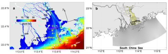
Figure 1.
(a) Bathymetry of the Pearl River Estuary (PRE). Lingding Bay is the largest bay in the PRE. Transects 1 and 2 represented the across-channel and along-channel transect in Lingding Bay, respectively. Station A (22.25° N, 113.75° E) and Macao airport (22.14° N, 113.5° E) mark the stations (squares) where wind forcing data were analyzed. Stations B and C mark the stations on Transects 1 and 2, respectively, where the velocity profiles are extracted and shown in the following. Freshwater enters the PRE through eight outlets: Humen (HUM), Jiaomen (JM); Hongqili (HQL), Hengmen (HEM), Modaomen (MDM), Jitimen (JTM), and Yamen (YM); (b) numerical model grids. The area in the Lingding Bay is marked for estimating the residence time in this area.
The long-term trend of wind has been investigated by several previous studies. The trend showed significant spatial and temporal variations. Using two long-term surface wind data sets, Li et al. [] showed that there was an overall strengthening trend of the trades in the western equatorial Pacific and an overall weakening trend in the eastern equatorial Pacific. Islek et al. [] used 40 years (1979–2019) of ERA-Interim and CFSR data to analyze the temporal and spatial variation characteristics of the wind field in the Black Sea. Their results showed that the wind fields in the western and northern Black Sea were stable and continuous, whereas those in the eastern Black Sea were complex and volatile owing to climate change. The analysis of 51 years of data (1961–2012) from the Guangzhou meteorological observation station showed a weakening trend in the local annual maximum wind speed []. Lobeto et al. [] revealed a poleward shift of trade-induced waves due to the Hadley cell expansion could be observed globally, causing a clear dipole change pattern in the tropical southern Atlantic and tropical Indian oceans. Yang et al. [] reported a poleward shift of the mid-latitude anticyclone in the South Atlantic Ocean during the past four decades, inducing long-term changes in wind stress and wind stress curl. The Brazil Current, in response to the wind change has intensified and shifted southwards during the past decades []. The enhancement of alongshore winds increases coastal upwelling, which in turn could reduce sea surface temperature and increase chlorophyll-a in the Chilean coastal zone [].
The Pearl River delta is the most densely populated area in southern China. Anthropogenic activities bring a large quantity of pollutants and nutrients to the PRE and adjacent coastal sea, which threaten the water quality and ecosystem in the delta. The Pearl River is the second largest river in China and has a complex river network. It has a drainage area of about 4.5 × 10⁵ km2 and discharges freshwater into the northern SCS through eight outlets: Humen, Jiaomen, Hongqili, Hengmen, Modaomen, Jitimen, Hutiaomen, and Yamen (Figure 1a). The total river discharge reaches a maximum in summer (~2.1 × 10⁴ m3/s) and a minimum in winter (~3.4 × 10³ m3/s) []. The study by Dai et al. [] indicated the water discharge of Pearl River did not show any significant trend from 1955 to 2005. Lingding Bay is the largest sub-estuary in the PRE. Bathymetric measurements have revealed Lingding Bay has a depth less than 5 m, except for the channels, which are 5–20 m in depth. The hydrodynamics in the PRE and adjacent coastal area have been investigated by several previous studies [,,,,]. These studies suggested that, from the viewpoint of dynamic mechanisms, the hydrodynamic circulation in the PRE is jointly driven by wind, tide and buoyancy flux from both the Pearl River and the open sea. The hydrodynamic condition in the PRE is very sensitive to climate change. Previous studies have examined the effect of the sea-level rise [] and decadal morphological evolution [] on the PRE hydrodynamic circulation. So far, the impact of climatic wind forcing change has not been examined in this area.
Wind can be of first-order importance for vertical mixing, lateral circulation, and wave generation in estuaries. Wind stress transfers horizontal momentum vertically downward across the air–sea interface and dominates the non-tidal motion of estuaries. Investigations of wind-driven estuarine circulation have revealed that wind speed and direction indeed play important roles in determining the pattern of circulation [,,,,,]. Meanwhile, estuarine circulation modulates saltwater intrusion [], oxygen exchange [,], sediment transport [], terrestrial dissolved substances transport [], nutrients distribution [] and water age [,]. Wind-induced flushing can cause large variations in freshwater residence time, salinity front, river plume, and nutrient transport [,,].
Along-channel winds usually generate lateral circulation via wind-induced lateral transport in the surface layer of estuaries. They can drive upwelling/downwelling flows and transport biologically important substances such as nutrients and oxygen between the deep channel and shallow shoals [,,,]. Scully [] found that the wind-driven lateral exchange of oxygen between well-oxygenated shallow shoals and the hypoxic deep channel may be more important than direct turbulent mixing in supplying oxygen to the deep channel of Chesapeake Bay. By analyzing mooring data, Xie et al. [] found that the lateral circulation featured a clockwise circulation (looking upstream) in the surface layer under up-estuary winds. Lai et al. [] studied the impact of tides and winds on PRE circulation and revealed that the cross-estuary adjustment of stratification and mixing induced by along-estuary wind is stronger than the along-estuary wind straining effect.
Changes in the wind field due to climate change could significantly affect the estuarine ecosystem. Wilson et al. [] indicated that climatic processes, namely the long-term changes in both the direction and directional constancy of summer winds, control the ventilation of bottom waters and thus the seasonal development of hypoxia in the western Long Island Sound. Scully [] indicated that the decadal-scale variability of climate forcing caused the change in wind direction over the Chesapeake Bay, which was responsible for the increased hypoxic volume from the early 1980s to the present.
However, in the PRE, the long-term trend of sea surface wind and its impact on the estuarine circulation have not been investigated. Due to the prevailing East Asian monsoon, the northeasterly and southwesterly wind occupies the PRE in winter and summer, respectively. Reversing the wind direction results in a different wind forcing effect in different seasons. To isolate the disturbance from seasonal variations, only the summertime wind trend is examined in this study. The wind trend in other seasons will be examined in our future works.
The primary goal of the present study is to investigate the long-term trend of summertime wind direction in the PRE and evaluate the response of estuarine hydrodynamics to such a climatic change. Based on the wind data over the past 42 years (1979–2020) and a calibrated 3D numerical model, the variations of PRE circulation under the past, present, and predicted future wind direction conditions are thoroughly explored. The results of this study will help to understand the adjustment of the local marine environment against the background of climate change.
2. Data and Methods
2.1. Data
The wind data used in this study were obtained from the latest ERA5 hourly data set at 10 m above the sea surface from 1979–2020. ERA5 is the global reanalysis product produced by ECMWF (https://www.ecmwf.int/en/forecasts/datasets/reanalysis-datasets/era5, accessed on 9 May 2022). It is based on a hybrid incremental 4D-Var system, which uses observations from over 200 satellite instruments or types of conventional data []. With a spatial resolution of 0.25° × 0.25°, ERA5 has higher spatial and temporal resolutions than the previous four generations of datasets.
2.2. Numerical Modeling
The three-dimensional hydrodynamic model EFDC (Environmental Fluid Dynamics Code) is implemented to investigate the responses of hydrodynamic circulation to long-term wind change in the PRE. The EFDC model was developed by the Virginia Institute of Marine Sciences, USA []. It is a multi-parameter finite difference model and can model the hydrodynamic circulation and water quality in rivers, lakes, estuaries, and oceans [,,,]. The model uses curvilinear-orthogonal coordinates in horizontal and σ coordinates in vertical. The EFDC model has been successfully applied in the PRE [,]. The model domain extended from the upstream river network to the adjacent shelf water of the northern SCS (Figure 1b). The horizontal resolution of the PRE model ranged from 40 m inside the PRE to approximately 1000 m on the open shelf. There are 20 σ layers vertically. The model configuration and external forcing fields used in this study were the same as those used by Hong et al. []. Model calibration and validation were carried out for tides, salinity, and current velocity on a variety of time scales. The detailed model configuration and model-data comparisons can be found in Hong et al. [].
3. Results
3.1. Climatic Change of Summertime Wind Forcing
Since the typical East Asia summer monsoon prevails in July [], the data in July will be used to evaluate the climatic change of summertime wind forcing in the PRE. The wind data from ERA5 were sampled at station A (see Figure 1 for the location). The mean data in July from 1979 to 2020 are presented in Figure 2. The wind speeds showed a decreasing trend and the wind directions showed a shift from southwesterly to southeasterly. The monthly mean wind data in July recorded at Macau Airport (22.22° N, 113.50° E) from 1997 to 2015 were also plotted in Figure 2. Good consistency can be found between the two datasets, which confirmed the robustness of the trend we obtained from the ERA5 data. More comparisons between ERA5 data and in situ observations from other sources indicated that ERA5 data show robust consistency with observed time series in both the wind speed and wind direction []. It is reliable to use ERA5 wind data to evaluate the climatic change of wind forcing in the PRE.
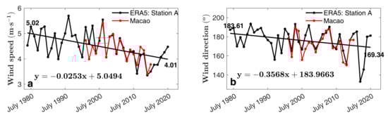
Figure 2.
The long-term trend of typical summertime wind speed (a) and wind direction (b) in the PRE from 1979 to 2020. The monthly mean wind data in July of each year were used to represent the typical summertime wind condition. Both the data from ERA5 (at station A, black line) and Macao Airport observation (red line) were analyzed.
The main channel of the PRE is largely in the northwest-southeast direction (Figure 1a), while the prevailing summer wind is largely aligned with the along-channel direction and towards upstream. Studies by Lai et al. [] and Xie et al. [] suggested that the along-channel wind is important in inducing the cross-channel adjustment. The lateral circulation can be closely related to the along-channel wind forcing. Our analysis indicates that both the wind speed and wind direction show a trend over the past 42 years. It is not easy to clarify their relative contribution to the hydrodynamic processes if the change in wind speed and wind direction are combined. Therefore, only the long-term shifting of wind direction is considered in this study.
The linear fit showed that the summertime wind direction shifted anticlockwise over the past 42 years and the rate was −0.36°yr−1. With this rate, the mean wind direction was around 183.6° and 169.3° in 1979 and 2020, respectively. The linearly predicted summer-time wind direction will be shifted to 152.3° and 142.1° by 2070 and 2100, respectively. Since we focused on investigating how the long-term change of wind direction affects the hydrodynamic circulation structure in the PRE, the numerical experiments were designed by using the trend to show the magnitude of the wind direction change over decadal years. The wind direction from a specific year was not representative for undertaking such an assessment. Taking the advantage of the 3D numerical model, a series of numerical experiments are conducted to evaluate the response of hydrodynamic processes in the PRE. Four numerical experiments, Case I–Case IV, are designed (see Table 1). Since the climatic change of wind speed is excluded in this study, the long-term mean wind speed in July, 4.52 m/s, is used in each experiment. The model settings for all the experiments are the same except for the wind direction in July. Specifically, the model is initialized by the outputs of the model run on 31 December 2007 (model–data comparison in 2007 had been conducted by Hong et al. []. The model is forced by the multiyear mean daily forcing field from 1 January to 31 August, except for the wind forcing from 1 July to 31 July, during which wind forcing was determined by the configuration in Table 1. For each case, the wind forcing in July did not show spatial and temporal variations. These numerical modeling experiments allowed us to clarify the hydrodynamic response that was caused by the climatic wind direction shifting particularly. The results of each case in July were used in the following analyses.

Table 1.
Numerical experiments were conducted to evaluate the modulation of climatic change of wind direction on the hydrodynamic condition in the PRE. Case I and Case II represent the condition at the beginning of the 1980s and 2020s, respectively. Case III and Case IV represent the condition predicted for 2070 and 2100, respectively. The mean wind speed of 4.52 m/s averaged from 1979–2020 are used in each case to exclude the effect of climatic wind speed change.
3.2. Responses of Lateral Circulation
Wind-driven lateral circulation is very important to the water exchange between the shoal and deep channel. In this section, we focus our analysis on the spatial structure variations of lateral circulation in response to the summer wind direction shifting. Figure 3 presents the mean lateral circulation and salinity in July along Transect 1 in the middle Lingding Bay, which is perpendicular to the main channel of the estuary (Figure 1a). It is a good spot to examine the lateral flow in the Bay.
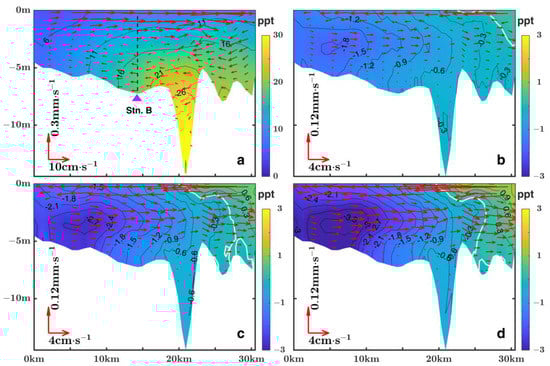
Figure 3.
Distribution of summertime lateral circulation and salinity along Transact 1 (looking landward). (a) Case I; (b) Case II–Case I; (c) Case III–Case I; (d) and Case IV–Case I. The black dotted line in (a) denotes the location of station B.
Under Case I conditions, results showed that the lateral circulation in Lingding Bay was clockwise (looking upstream) in summer (Figure 3a). The eastward surface flow was in the magnitude of 15 cm/s, which was stronger than the westward bottom flow. This is consistent with the observations presented by Xie et al. [], which indicated a clockwise circulation under up-estuary winds in the Chesapeake Bay. The upper layer eastward surface flow is consistent with a generation mechanism by the lateral wind-driven flow. The saltwater mainly occupies the deep channel. Fresher water mass occupies the western shoal with relatively good mixing. The lateral circulation caused isopycnals to tilt in the western shoal, forming a lateral salinity front in the western shoal. Figure 3b–d shows the difference between Case II, Case III, and Case IV in relation to Case I, respectively. It was clearly indicated that, as wind direction shifts from southwesterly to southeasterly, the lateral circulation was weakened, and the salinity decreased. By 2100 (Figure 3d), the mean wind direction in July can be 142.1°, and the corresponding lateral circulation decrease was much stronger than those in Case II and III.
It is interesting to find that the most obvious salinity decrease appeared in the western shoal, while the minimum salinity decrease appeared in the deep channel. The spatial pattern of the lateral circulation indicated that the westward bottom flow could help to transport the deep channel saltwater to the western shoal. As the wind direction shifted to southeasterly, this flow was weakened, thus, the westward transport of saltwater decreased. As a result, the salinity at the western shoal decreases. By 2100, such salinity decrease could be more than 3 ppt (Figure 3d). The changes in the lateral circulation in the main channel were relatively minor. The resulting salinity change was minimum in the main channel.
In order to better quantify the changes in lateral flow, velocity profiles at the center station of the Transect 1 (Station B in Figure 1a and Figure 3a) were selected to show their relative changes in each case (Figure 4). The change of lateral flow mainly occurred in the upper and middle portion of the water column; the difference in the bottom layer was almost invisible. With the climate change, the changes of upper layer lateral flow tend to be larger as the wind direction shifting continues. By 2100, the decrease of lateral flow could be as large as 10 cm/s. The vertical shear of the lateral flow could also be greatly modified. The anticlockwise shift of wind direction weakened the wind-driven cross-channel transport, thus, modifying the surface layer flow, which in turn led to the adjustment of the lower layer circulation.
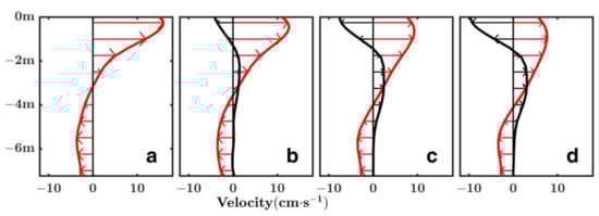
Figure 4.
Vertical profiles of the summertime cross-channel velocity at station B (see Figure 1a and Figure 3a for the location). The red lines denote the cross-channel velocity obtained from Case I (a), Case II (b), Case III (c), and Case IV, respectively. The black lines denote the velocity difference in each case: (b) Case II–Case I; (c) Case III–Case I; and (d) Case IV–Case I.
3.3. Responses of Along-Channel Circulation
To quantify the spatial variations of along-channel circulation changes, the difference between Case I and the rest of the Cases were plotted at the along-channel transect (Transect 2 in Figure 1a). Figure 5a shows the spatial pattern of along-channel circulation in Case I. There is a strong exchange flow accompanied by the salinity front in the Linding Bay. The flow is uniformly seaward in the Humen channel due to the high river discharge in summer. In comparison with the results in other Cases, we found the surface, seaward flow was weakened, while wind direction shifted anticlockwise. The most remarkable decrease in salinity field can be found in the area where the salinity front occupies. The largest salinity decrease occurred in the lower bay. By 2100, the salinity decrease could be as large as 2.5 ppt.
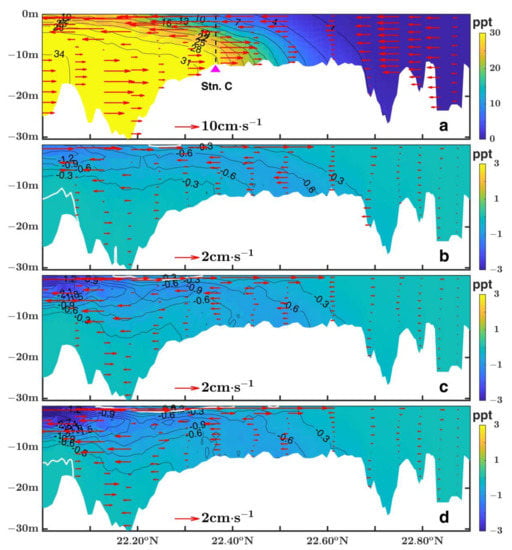
Figure 5.
Distribution of summertime exchange flow and salinity along the Transact 2. (a) Case I; (b) Case II–Case I; (c) Case III–Case I; and (d) Case IV–Case I. The black dotted line in (a) denotes the location of station C.
For a clearer exhibition of the response of along-channel circulation to the wind direction shifting, the vertical profiles of the along-channel flow at the middle PRE (Station C in Figure 1a and Figure 5a) are shown in Figure 6. Only minor flow changes were discerned in the upper layer. By 2100, the maximum decrease of flow will be around 4 cm/s in the surface layer (Figure 6d). It can be concluded that, unlike the lateral flow, the along-channel exchange flows only show minor changes as wind direction shifting.
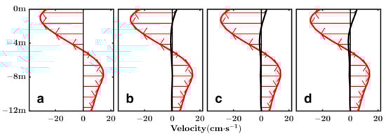
Figure 6.
Vertical profiles of the summertime along-channel (exchange flow) velocity at station C (see Figure 1a and Figure 5a for the location). The red lines denote the along-channel velocity obtained from Case I (a), Case II (b), Case III (c) and Case IV, respectively. The black lines denote the velocity difference in each case: (b) Case II–Case I; (c) Case III–Case I; and (d) Case IV–Case I.
3.4. Responses of Stratification
Being a partially mixed estuary, the PRE receives a large amount of freshwater from the Pearl River, which enters the estuary through 8 outlets. The stratification in the PRE is the result of the competition among freshwater discharge, saltwater intrusion, wind forcing, and tidal forcing. Figure 7 presents the horizontal distribution of circulation and salinity under Case I conditions. The pattern of surface and bottom layer salinity distribution in other Cases was similar to those in Case I. The river plume spread southeastward under the impact of the summer monsoon and the saltwater enters the Linding Bay along the main channel. The spatial distribution of stratification from Case I–IV is shown in Figure 8 to show the response of stratification to the wind direction shifting. Here the stratification (∆S) was estimated by using the difference between the bottom (Sb) and surface (Ss) salinity field. It is surprising to find that the remarkable increase of stratification appears along the western coast of PRE, especially the coastal sea adjacent to the Modaomen. As wind direction shifts to southeasterly, wind-driven transport induces river discharge from the western four outlets to be confined and transported along the coastline of the PRE instead of being spread to the open sea (see Figure 7a for the surface circulation). Thereby, both the intensity and the range of the high stratification water increase as wind direction shifting. By 2100, the predicted wind direction is 142.1° and the high stratification water extends westward and occupies the coastal sea all along the western PRE. Cui et al. [] presented the historic hypoxia area in the PRE and adjacent shelf sea in the past three decades. Combing the hydrological survey, they suggested the hypoxia area is consistent with the area where stratification is strong. Our analyses show similar high stratification spots with Cui et al. []. It is likely that hypoxia will happen more frequently in the coastal sea adjacent to the Modaomen as wind direction shifting continues due to climate change.
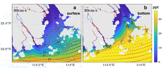
Figure 7.
Distribution of summertime circulation and salinity in the Pearl River Estuary from Case I. (a) Surface layer; (b) bottom layer.
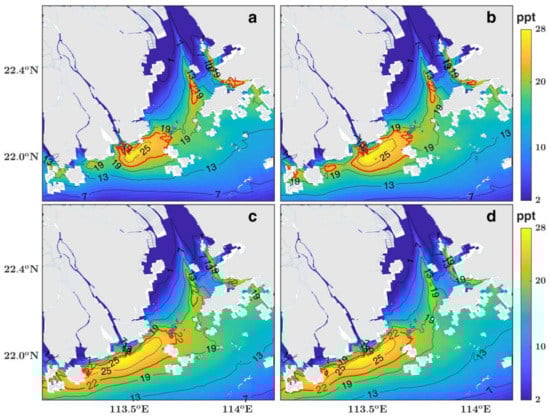
Figure 8.
Stratification (∆S = Sb−Ss) in the Pearl River Estuary in summer. (a) Case I; (b) Case II; (c) Case III; and (d) Case IV. The red lines mark the value of 22 ppt, which denotes the area with stronger stratification.
4. Discussion
Wind-driven motions often dominate the non-tidal motion of estuaries. Many observations and numerical modeling has revealed that upstream wind forcing is important for estuarine lateral circulation and substance transport. Wind forcing modulates the physical processes, thereby modulating the biogeochemical processes. Previous studies mostly focus on the effects of wind events. The effect of climatic change on wind direction has not been explored in the PRE. Our results in Section 3 suggest the long-term change of wind field can induce significant changes in the estuarine hydrodynamics. It is worthwhile to evaluate the factors that contribute to the hydrodynamic changes in the PRE.
4.1. Residence Time and Flow Intensity
Residence time is a key parameter for evaluating transport processes in an estuary. It can be used to estimate the net effect of hydrodynamic circulation changes from different aspects. Since both the along-channel flow and the lateral circulation are changed, it is necessary to evaluate the residence time to clarify the changes in transport processes in the PRE. Here, the mean residence time of Lingding Bay is calculated by using passive tracers. Tracers were released simultaneously throughout the entire Bay. Since we only focus on the summer-time condition, tracers were released on 1 July. The residence time corresponds to the time when the mean tracer concentration in the Bay reached its e-folding value. The results from Case I and II are shown in Figure 9a. The area of Lingding Bay is almost 2000 km2. In Case I, it takes about 12 days for the mean tracer concentration to reach its e-folding value. The residence time increased about 1 day in Case II, which indicates the transport process in the PRE is getting slower while the wind direction shifts southeasterly. As shown in Section 3, the lateral and longitudinal circulation decreases when the wind direction shifts. It will take longer time for the Bay to be renewed. It can be expected that the residence time could be further increased by 2100 while the wind direction is predicted to shift anticlockwise continuously (Figure not shown).
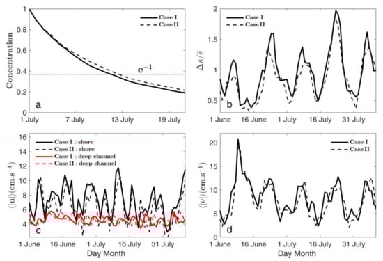
Figure 9.
(a) Residence time in Lingding Bay (marked by the yellow dots in Figure 1b); (b) time series of stratification averaged along Transect 1; (c) time series of the intensity of cross-channel flow averaged along Transect 1; (d) time series of the intensity of along-channel flow averaged along Transect II. Bold lines and dotted lines represent the result from Case I and Case II, respectively.
The time series of stratification parameter (the salinity difference between surface and bottom layer divided by the depth-averaged salinity) averaged along Transect 1 indicates the stratification in Case II is weaker than those in Case I (Figure 9b). As the intensity of stratification varies during the spring and neap tide, the stratification difference in Case I and Case II is much larger during the neap tide than in other periods. There are complicated nonlinear interactions among the forcing fields.
In order to measure the strength of the lateral and longitudinal flow, the cross-sectional averaged velocities are calculated by
and
, respectively. Here
and
are the cross-channel and the along-channel component of velocity,
is the cross-sectional area, and the angle brackets denote tidal average. The time series of the lateral and longitudinal flow intensity are shown in Figure 9c,d, which are averaged along Transect I and II, respectively. Compared with the results in Case I, the lateral flow is generally weaker in Case II in the western shoal. The lateral flow in the deep channel does not show consistent change as those in the shoal. The wind direction shifting has a relatively minor effect on the deep channel lateral flow intensity, which can also be seen in Figure 3 and Figure 4. Figure 9d indicates that the longitudinal flow intensity in Case II is generally weaker than those in Case I. The longitude flow is affected by runoff and reaches its peak appears around 8 June. It should be noted that when the maximum runoff occurs, the peak longitude flow occurs in both Case I and Case II while the strength of lateral flow does not show such a response to runoff. The lateral circulation is more sensitive to the wind direction change than the longitudinal flow. It has been reported that wind can drive upwelling/downwelling flows along the cross-channel transect, which facilitates the development of lateral circulation in estuaries [,,,]. As climate change, the along-channel wind is shifting from southerly to southeasterly in the PRE. Such wind direction shifting leads to the direct response of lateral flow. Our numerical model results are within the range of the previous theoretical and observational results.
4.2. Momentum Budget
To investigate the driving force for the circulation variation in response to the wind direction shifting, we calculate the momentum terms that drive the cross-channel and along-channel circulation. The momentum balance can be written as:
where , and are the cross-channel along-channel, and vertical velocity components; is the vertical eddy viscosity; and are the water density and averaged water density, respectively; and is the Coriolis parameter. The term 1–6 are the tendency, advection, Coriolis force, barotropic pressure, baroclinic pressure, and diffusion term, respectively. The difference in each term between Case I and Case II (Case II–Case I) are shown in Figure 10 and Figure 11 for the cross-channel and along-channel momentum terms, respectively. Each momentum term in Equations (1) and (2) is averaged in July.
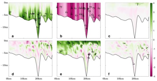
Figure 10.
Difference of cross-channel momentum terms between Case II and Case I (Case II–Case I, looking landward). (a) Baroclinic pressure gradient; (b) barotropic pressure gradient; (c) coriolis force; (d) advective; (e) diffusion, and (f) tendency. All the terms are averaged in July. The eastward is positive. All the data were scaled by 10−5.
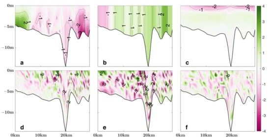
Figure 11.
Difference of along-channel momentum terms between Case II and Case I (Case II–Case I, looking landward). (a) Baroclinic pressure gradient; (b) barotropic pressure gradient; (c) coriolis force; (d) advective; (e) diffusion, and (f) tendency. All the terms are averaged in July. The eastward is positive. All the data were scaled by 10−5.
For the cross-channel momentum budget, wind direction shifting causes the major change in the barotropic pressure term (Figure 10b), which is mainly balanced by the changes in the baroclinic pressure term (Figure 10a) and the diffusion term (Figure 10e). In combination with the water elevation distribution along Transect I (Figure 12a), it is revealed that the changes in the lateral circulation in response to the wind direction shifting is mainly caused by the changes in water elevation gradient (i.e., the barotropic term in Equation (1), ). Such change is balanced by the changes in density gradient in the deep layer (Figure 10a) and the stress divergence in the upper layer (Figure 10e). The summertime wind forcing is largely in the along-channel direction of the PRE. Along-channel winds can generate lateral circulation via lateral wind-driven transport in the surface layer of estuaries. As the wind direction has shifted to the southeasterly during the past 42 years, the cross-channel wind-driven transport is weakened. Such change leads to the weakening of surface layer cross-channel flow and cross-channel water elevation gradient, which in turn lead to the weakening of clockwise adjustment of lateral circulation. The feature shown in the momentum budget is consistent with our results shown in Section 3.2 and Figure 12a.
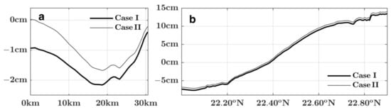
Figure 12.
Water elevation along Transect 1 (a) and Transect 2 (b) in Case I and II, respectively. The results are averaged in July.
The along-channel momentum budget shows different features. Considering the difference between Case I and Case II (Case II–Case I), the baroclinic term and the barotropic term show different tendencies in the western shoal and the remaining part of the Transect 1. Unlike the cross-channel momentum budget, there is no typical term balance that dominates the change of momentum terms. In the upper layer, the change of Coriolis term is consistent with the change of flow shown in Section 3. The remarkable change of density gradient term occurs in the bottom layer of shoal and the increasement (decreasement) can be found in the western (eastern) shoal. As the wind direction shifts to southeasterly, the along-channel flows show different responses in different areas. The stress divergence term also indicates there are complicated nonlinear responses to the wind direction shifting. The distribution of water elevation along Transect 2 also suggests the change of water elevation as wind direction shifting is minor. These are consistent with the results shown in Section 3.2. The along-channel circulation has an insignificant response to the summertime wind direction shifting except in the shoal area.
5. Conclusions
Using long-term (1979–2020) wind data from ERA5 global reanalysis product and a fully calibrated 3D numerical model, we have investigated the climatic change of summertime wind direction in the PRE and its impact on the estuarine circulation. Analyzing results revealed that the wind direction in the PRE shifted anticlockwise over the past 42 years at a rate of −0.36°yr−1. The mean wind direction in July shifted from 183.6° (in 1979) to 169.3° (in 2020). The predicted wind direction will be 152.3° and 142.1° by 2070 and 2100, respectively. Numerical experiments are conducted to evaluate the response of hydrodynamic processes to wind direction shifting. Model results indicate the lateral circulation is obviously weakened and the salinity decreases along the cross-channel transect. The change of lateral flow mainly occurs in the upper portion of the water column. By 2100, the predicted decrease of lateral flow can be as large as 10 cm/s in the surface layer. The along-channel flow is weakened in the surface layer but shows a very minor change in the bottom layer. A remarkable increase in stratification appears along the western coast of the PRE, especially in the coastal area adjacent to the Modaomen. It is likely that hypoxia will happen more frequently in the coastal sea adjacent to the Modaomen as wind direction shifting continues due to climate change.
The anticlockwise shift of wind direction has weakened the cross-channel wind-driven transport, thus modifying the surface layer flow, which in turn leads to the adjustment of the lower layer circulation. The residence time of Lingding Bay could be increased as wind direction shifting continues. Momentum budget indicates that the barotropic pressure term causes the major change of hydrodynamic circulation. Such change is mainly balanced by the changes in the baroclinic pressure term and diffusion term.
Author Contributions
Conceptualization, B.H., H.X. (Hanlu Xue), L.Z. and H.X. (Hongzhou Xu); methodology, B.H. and H.X. (Hongzhou Xu); software, B.H., H.X. (Hanlu Xue), and H.X. (Hongzhou Xu); validation, B.H., L.Z. and H.X. (Hongzhou Xu); formal analysis, B.H. and H.X. (Hanlu Xue); investigation, B.H., H.X. (Hanlu Xue), and H.X. (Hongzhou Xu); resources, B.H. and H.X. (Hongzhou Xu); data curation, B.H. and H.X. (Hongzhou Xu); writing—original draft preparation, B.H. and H.X. (Hanlu Xue); writing—review and editing, B.H., L.Z. and H.X. (Hongzhou Xu); visualization, H.X. (Hanlu Xue), B.H. and L.Z.; supervision, B.H. and H.X. (Hongzhou Xu); project administration, B.H.; funding acquisition, B.H. All authors have read and agreed to the published version of the manuscript.
Funding
This research was funded by the National Natural Science Foundation of China (Grant number 41976014, 51761135021, and 41666001), the National Natural Science Foundation of Guangdong Province (Grant number 2022A1515011736), and the CAS Frontier Basic Research Project (Grant number QYJC201910).
Institutional Review Board Statement
Not applicable.
Informed Consent Statement
Not applicable.
Data Availability Statement
Not applicable.
Acknowledgments
We thank the EFDC code developer and the financial support from NSF China and NSF Guangdong province. We also thank ECMWF for providing the long-term wind data.
Conflicts of Interest
The authors declare no conflict of interest.
References
- IPCC. Climate Change 2021: The Physical Science Basis. Contribution of Working Group I to the Sixth Assessment Report of the Intergovernmental Panel on Climate Change; Cambridge University Press: Cambridge, UK; New York, NY, USA, 2021; pp. 287–422. [Google Scholar] [CrossRef]
- Wang, B.; Huang, F.; Wu, Z.; Yang, J.; Fu, X.; Kikuchi, K. Multi-scale climate variability of the South China Sea monsoon: A review. Dyn. Atmos. Oceans 2009, 47, 15–37. [Google Scholar] [CrossRef]
- Parvathi, V.; Suresh, I.; Lengaigne, M.; Izumo, T.; Vialard, J. Robust Projected Weakening of Winter Monsoon Winds over the Arabian Sea under Climate Change. Geophys. Res. Lett. 2017, 44, 9833–9843. [Google Scholar] [CrossRef]
- Islek, F.; Yuksel, Y.; Sahin, C. Spatiotemporal long-term trends of extreme wind characteristics over the Black Sea. Dyn. Atmos. Oceans 2020, 90, 101132. [Google Scholar] [CrossRef]
- Gai, C.; Liu, Q.; Roberts, A.P.; Chou, Y.; Zhao, X.; Jiang, Z.; Liu, J. East Asian monsoon evolution since the late Miocene from the South China Sea. Earth Planet. Sci. Lett. 2020, 530, 115960. [Google Scholar] [CrossRef]
- Mo, H.; Hong, H.; Fan, F. Estimating the extreme wind speed for regions in China using surface wind observations and reanalysis data. J. Wind Eng. Ind. Aerodyn. 2015, 143, 19–33. [Google Scholar] [CrossRef]
- Shi, P.; Zhang, G.; Kong, F.; Ye, Q. Wind speed change regionalization in China (1961–2012). Adv. Clim. Chang. Res. 2015, 6, 151–158. [Google Scholar] [CrossRef]
- Jiang, Y.; Luo, Y.; Zhao, Z. Maximum wind speed changes over China. Acta Meteorol. Sin. 2013, 27, 63–74. [Google Scholar] [CrossRef]
- Yang, M.; Xu, H.; Li, W.; Liu, Y. Variations of East Asian monsoon and its relationships with land-sea temperature in recent 40 years. J. Appl. Meteor. Sci. 2008, 19, 522–530. [Google Scholar]
- Liang, J.; Yang, S.; Li, C.; Li, X. Long-term changes in the South China Sea summer monsoon revealed by station observations of the Xisha Inland. J. Geophys. Res. Atmos. 2007, 112, D10104. [Google Scholar] [CrossRef]
- Hong, B.; Zhang, J. Long-term trends of sea surface wind in the northern south China Sea under the background of climate change. J. Mar. Sci. Eng. 2021, 9, 752. [Google Scholar] [CrossRef]
- Li, Y.; Chen, Q.; Liu, X.; Li, J.; Xing, N.; Xie, F.; Feng, J.; Zhou, X.; Cai, H.; Wang, Z. Long-term trend of the tropical Pacific trade winds under global warming and its causes. J. Geophys. Res.-Oceans. 2019, 124, 2626–2640. [Google Scholar] [CrossRef]
- Lobeto, H.; Menendez, M.; Losada, I.J.; Hemer, M. The effect of climate change on wind-wave directional spectra. Glob. Planet. Change 2022, 213, 103820. [Google Scholar] [CrossRef]
- Yang, H.; Lohmann, G.; Krebs-Kanzow, U.; Ionita, M.; Shi, X.; Sidorenko, D.; Gowan, E.J. Poleward shift of the major ocean gyres detected in a warming climate. Geophys. Res. Lett. 2020, 47, e2019GL085868. [Google Scholar] [CrossRef] [Green Version]
- Franco, B.C.; Defeo, O.; Piola, A.R.; Barreiro, M.; Yang, H.; Ortega, L.; Gianelli, I.; Castello, J.P.; Vera, C.; Buratti, C.; et al. Climate change impacts on the atmospheric circulation, ocean, and fisheries in the southwest South Atlantic Ocean: A review. Clim. Change 2020, 162, 2359–2377. [Google Scholar] [CrossRef]
- Grez, P.W.; Aguirre, C.; Farías, L.; Contreras-López, M.; Masotti, T. Evidence of climate-driven changes on atmospheric, hydrological, and oceanographic variables along the chilean coastal zone. Clim. Change 2020, 163, 633–652. [Google Scholar] [CrossRef]
- Zhao, H. The Evolution of the Pearl River Estuary; China Ocean Press: Beijing, China, 1990; p. 357. [Google Scholar]
- Dai, S.B.; Yang, S.L.; Cai, A.M. Impacts of dams on the sediment flux of the Pearl River, southern China. Catena 2008, 76, 36–43. [Google Scholar] [CrossRef]
- Zheng, S.; Guan, W.B.; Cai, S.Q.; Wei, X.; Huang, D.J. A model study of the effects of river discharges and interannual variation of winds on the plume front in winter in Pearl River Estuary. Cont. Shelf Res. 2014, 73, 31–40. [Google Scholar] [CrossRef]
- Lai, W.; Pan, J.; Devlin, A.T. Impact of tides and winds on estuarine circulation in the Pearl River Estuary. Cont. Shelf Res. 2018, 168, 68–82. [Google Scholar] [CrossRef]
- Gong, W.P.; Lin, Z.Y.; Chen, Y.Z.; Chen, Z.Y.; Zhang, H. Effect of winds and waves on salt intrusion in the Pearl River estuary. Ocean Sci. 2018, 14, 139–159. [Google Scholar] [CrossRef] [Green Version]
- Lin, Z.Y.; Zhang, H.; Lin, H.; Gong, W.P. Intraseasonal and interannual variabilities of saltwater intrusion during dry seasons and the associated driving forcings in a partially mixed estuary. Cont. Shelf Res. 2019, 174, 95–107. [Google Scholar] [CrossRef]
- Xu, H.; Shen, J.; Wang, D.; Luo, L.; Hong, B. Nonlinearity of subtidal estuarine circulation in the Pearl River Estuary, China. Front. Mar. Sci. 2021, 8, 629403. [Google Scholar] [CrossRef]
- Hong, B.; Liu, Z.H.; Shen, J.; Wu, H.; Gong, W.P.; Xu, H.Z.; Wang, D.X. Potential physical impacts of sea-level rise on the Pearl River Estuary, China. J. Marine Syst. 2020, 201, 103245. [Google Scholar] [CrossRef]
- Zhang, R.; Hong, B.; Zhu, L.; Gong, W.; Zhang, H. Responses of estuarine circulation to the morphological evolution in a convergent, microtidal estuary. Ocean Sci. 2022, 18, 213–231. [Google Scholar] [CrossRef]
- Geyer, W.R. Influence of wind on dynamics and flushing of shallow estuaries. Estuarine Coastal Shelf Sci. 1997, 44, 713–722. [Google Scholar] [CrossRef]
- Scully, M.E.; Friedrichs, C.; Brubaker, J. Control of the estuarine stratification and mixing by wind-induced straining of the estuarine density field. Estuaries Coasts 2005, 28, 321–326. [Google Scholar] [CrossRef]
- Chen, S.N.; Sanford, L.P. Axial wind effects on stratification and longitudinal salt transport in an idealized, partially mixed estuary. J. Phys. Oceanogr. 2009, 39, 1905–1920. [Google Scholar] [CrossRef]
- Scully, M.E. Wind modulation of dissolved oxygen in Chesapeake Bay. Estuaries Coasts 2010, 33, 1164–1175. [Google Scholar] [CrossRef]
- Li, Y.; Li, M. Effects of winds on stratification and circulation in a partially mixed estuary. J. Geophys. Res. 2011, 116, C12012. [Google Scholar] [CrossRef]
- Scully, M.E. Physical controls on hypoxia in Chesapeake Bay: A numerical modeling study. J. Geophys. Res. Oceans 2013, 118, 1239–1256. [Google Scholar] [CrossRef] [Green Version]
- Gong, W.; Wang, Y.; Jia, J. The effect of interacting downstream branches on saltwater intrusion in the Modaomen Estuary, China. J. Asian Earth Sci. 2012, 45, 223–238. [Google Scholar] [CrossRef]
- Scully, M.E. The importance of climate variability to wind-driven modulation of hypoxia in Chesapeake Bay. J. Phys. Oceanogr. 2010, 40, 1435–1440. [Google Scholar] [CrossRef]
- Hong, B.; Shen, J. Linking dynamics of transport timescale and variations of hypoxia in the Chesapeake. J. Geophys. Res. 2013, 118, 6017–6029. [Google Scholar] [CrossRef] [Green Version]
- Chen, S.; Sanford, L.; Ralston, D. Lateral circulation and sediment transport driven by axial winds in an idealized partially, mixed estuary. J. Geophys. Res. 2009, 114, C12006. [Google Scholar] [CrossRef] [Green Version]
- Hong, B.; Xu, H.; Wang, D. Study on the Transport of Terrestrial Dissolved Substances in the Pearl River Estuary Using Passive Tracers. Water 2020, 12, 1235. [Google Scholar] [CrossRef]
- Du, J.; Shen, J.; Park, K.; Wang, Y.; Yu, X. Worsened physical condition due to climate change contributes to the increasing hypoxia in Chesapeake Bay. Sci. Total Environ. 2018, 630, 707–717. [Google Scholar] [CrossRef]
- Gong, W.; Shen, J.; Hong, B. The influence of wind on the water age in the tidal RappahannockRiver. Mar. Environ. Res. 2009, 68, 203–216. [Google Scholar] [CrossRef] [Green Version]
- Hong, B.; Shen, J. Responses of estuarine salinity and transport processes to potential future sea-level rise in the Chesapeake Bay. Estuar. Coast. Shelf Sci. 2012, 104–105, 33–45. [Google Scholar] [CrossRef]
- Shen, J.; Haas, L. Calculating age and residence time in the tidal York River using three-dimensional model experiments. Estuar. Coast. Shelf Sci. 2004, 61, 449–461. [Google Scholar] [CrossRef]
- Xia, M.; Xie, L.; Pietrafesa, L.J.; Whitney, M.M. The ideal response of a Gulf of Mexico estuary plume to wind forcing: Its connection with salt flux and a Lagrangian view. J. Geophys. Res. 2011, 116, C08035. [Google Scholar] [CrossRef]
- Reynolds-Fleming, J.V.; Luettich, R. Wind-driven lateral variability in a partially mixed estuary. Estuar. Coast. Shelf Sci. 2004, 60, 95–407. [Google Scholar] [CrossRef]
- Wilson, R.E.; Swanson, R.L.; Crowley, H.A. Perspectives on long-term variations in hypoxic conditions in western Long Island Sound. J. Geophys. Res. 2008, 113, 12011. [Google Scholar] [CrossRef] [Green Version]
- Xie, X.; Li, M.; Boicourt, W.C. Baroclinic effects on wind-driven lateral circulation in Chesapeake Bay. J. Phys. Oceanogr. 2017, 47, 433–445. [Google Scholar] [CrossRef]
- Bonavita, M.; Hólm, E.; Isaksen, L.; Fisher, M. The evolution of the ECMWF hybrid data assimilation system. Q. J. R. Meteorol. Soc. 2016, 142, 287–303. [Google Scholar] [CrossRef]
- Hamrick, J.M.; Wu, T.S. Computational design and optiShenmization of the EFDC/HEM3D surface water hydrodynamic and eutrophication models. In Next Generation Environmental Models and Computational Methods; Delich, G., Wheeler, M.F., Eds.; Society for Industrial and Applied Mathematics: Philadelphia, PA, USA, 1997; pp. 143–161. [Google Scholar]
- Zhu, L.; Gong, W.; Zhang, H.; Huang, W.; Zhang, R. Numerical study of sediment transport time scales in an ebb-dominated waterway. J. Hydrol. 2020, 591, 125299. [Google Scholar] [CrossRef]
- Cui, Y.S.; Wu, J.X.; Ren, J.; Xu, J. Physical dynamics structures and oxygen budget of summer hypoxia in the Pearl River Estuary. Limnol. Oceanogr. 2018, 64, 131–148. [Google Scholar] [CrossRef]
Publisher’s Note: MDPI stays neutral with regard to jurisdictional claims in published maps and institutional affiliations. |
© 2022 by the authors. Licensee MDPI, Basel, Switzerland. This article is an open access article distributed under the terms and conditions of the Creative Commons Attribution (CC BY) license (https://creativecommons.org/licenses/by/4.0/).