Review

Management and Sustainable Exploitation of Marine Environments through Smart Monitoring and Automation

1
Stazione Zoologica Anton Dohrn, Department of Ecosustainable Marine Biotechnology, Villa Comunale, 80121 Naples, Italy
2
Department of Biology, University of Naples Federico II, Complesso Universitario di Monte Sant’Angelo, Via Cinthia 21, 80126 Naples, Italy
3
Sensichips Srl., Via Fanciulla d’Anzio 9, 00042 Anzio, Italy
4
DIEI—Dipartimento di Ingegneria Elettrica e dell’Informazione, Università di Cassino e del Lazio Meridionale, Via G. Di Biasio 43, 03043 Cassino, Italy
5
Dipartimento di Ingegneria dell’Informazione, Università di Pisa, Via Caruso 16, 56122 Pisa, Italy
*
Authors to whom correspondence should be addressed.
J. Mar. Sci. Eng. 2022, 10(2), 297; https://doi.org/10.3390/jmse10020297
Submission received: 30 October 2021 / Revised: 28 January 2022 / Accepted: 10 February 2022 / Published: 21 February 2022
(This article belongs to the Special Issue Marine Environment Monitoring)

Abstract

:
Monitoring of aquatic ecosystems has been historically accomplished by intensive campaigns of direct measurements (by probes and other boat instruments) and indirect extensive methods such as aero-photogrammetry and satellite detection. These measurements characterized the research in the last century, with significant but limited improvements within those technological boundaries. The newest advances in the field of smart devices and increased networking capabilities provided by emerging tools, such as the Internet of Things (IoT), offer increasing opportunities to provide accurate and precise measurements over larger areas. These perspectives also correspond to an increasing need to promptly respond to frequent catastrophic impacts produced by drilling stations and intense transportation activities of dangerous materials over ocean routes. The shape of coastal ecosystems continuously varies due to increasing anthropic activities and climatic changes, aside from touristic activities, industrial impacts, and conservation practices. Smart buoy networks (SBNs), autonomous underwater vehicles (AUVs), and multi-sensor microsystems (MSMs) such as smart cable water (SCW) are able to learn specific patterns of ecological conditions, along with electronic “noses”, permitting them to set innovative low-cost monitoring stations reacting in real time to the signals of marine environments by autonomously adapting their monitoring programs and eventually sending alarm messages to prompt human intervention. These opportunities, according to multimodal scenarios, are dramatically changing both the coastal monitoring operations and the investigations over large oceanic areas by yielding huge amounts of information and partially computing them in order to provide intelligent responses. However, the major effects of these tools on the management of marine environments are still to be realized, and they are likely to become evident in the next decade. In this review, we examined from an ecological perspective the most striking innovations applied by various research groups around the world and analyzed their advantages and limits to depict scenarios of monitoring activities made possible for the next decade.

1. Current Policies for Environmental Monitoring and Conservation

The monitoring of marine environments has attracted increasing attention due to the growing concerns about climate change, along with intensified transportation activities, possibly producing direct, indirect, and stochastic impacts. In fact, a key challenge in contemporary ecology and conservation management is the accuracy of tracking of the spatial distribution of human impacts, including oil spills and chemical pollution, along with the evaluation of environmental quality and fishery activities [1]. Automation is an important part of the new generation of information technology, and it represents the ultimate achievement in the development of ocean monitoring programs. Various emerging technologies developed in the last decade include smart devices for the collection of information and their sharing over networks, as well as emerging technologies such as the Internet of Things (IoT), often foreseen as the future solution to an intelligent monitoring assembly [2].
The systems currently in use generally consist of observatories connected to a network system lying on the seafloor or connected to the surface by, for example, a buoy. In the first case, an example of a stable observatory is the Dense Ocean Floor Network System for Earthquakes and Tsunamis (DONET) by the Japan Agency for Marine-Earth Science and Technology (JAMSTEC). DONET is a submarine-cabled real-time seafloor observatory network intended for large-scale research and earthquake and tsunami monitoring. The program, which began in 2006, consists of several phases involving an increase in the number of observatories.
This system concept consists of a high-reliability backbone cable, which provides the power line and the communications channel, connecting several nodes with different measurement instruments [3].
Buoy systems are widely applied as well to monitor ocean environments, and meteorological and oceanographic instrumentation platforms able to share meteorological and environmental data in real time are critical to promptly respond to critical events. The development of newer buoys is able to improve early detection and real-time reporting of events in the open oceans, which is fundamental for the forecasting and reporting of tsunamis. For example, forecasting and reporting of tsunamis were made possible by the development of newer buoys able to improve early detection and real-time reporting of events in the open oceans [4,5]. Similarly, the realization of systems able to detect the presence of pollutants in the marine environment (including hydrocarbons, often requiring prompt reactions due to ship collisions and other disasters) has become extremely complex, involving various technologies and integrated know-how [6] further discussed below. Stations for deep-ocean assessment and reporting of tsunamis were developed ad hoc by NOAA (https://www.ndbc.noaa.gov/dart/dart.shtml; accessed on 30 November 2021) to acquire critical data for real-time forecasts in key regions [7]. The network is presently composed of 39 stations (Figure 1). This station system was named DART®, and it consists of bottom pressure recorders (BPRs) anchored to the seafloor coupled with a companion moored surface buoy for real-time communications [4]. An acoustic link transmits data from the BPR on the seafloor to the surface buoy. However, the main constraint for ocean monitoring systems is represented by communications, because it is almost impossible to deliver the measured data to remote monitoring sites without the aid of satellite communications [8]. To extend the communication coverage of a buoy network, a wireless mesh network (WMN) can be adopted (i.e., a communication network containing multiple radio nodes consisting of mesh routers and clients organized into a mesh topology). Since mesh routers can forward a message deriving from other nodes (even outside the transmission coverage of their destination), a multi-hop relay network (MHRN) may be arranged. An MHRN can extend the coverage of wireless communications, and it provides line-of-sight (LOS) links between couples of nodes. Mesh networks provide many advantages, including reliability, robustness, self-organization, and self-configuration [9].
Thus far, it is evident that marine monitoring of natural environments is a tremendously wide field of study, taking advantage of various disciplines and comprising several aspects including the biology of species, the ecology of aquatic environments, the technology of new devices, and the chemistry of water as revealed by probes, with the inclusion of newer smart tools for detection and transmission. A complete analysis of all these aspects cannot be achieved and discussed within a single literature synthesis. For this reason, here we analyze the current literature to present several (but not necessarily all) recently developed methodologies and technologies to improve marine monitoring methods in order to highlight new trends and modern perspectives on the study of coastal and offshore environments, which are changing fast due the introduction of important innovations. In addition, we introduce some newly developed tools and experimental data collected at our laboratory in order to broaden the analysis of coastal tools with the introduction of smart sensors and autonomous monitoring buoys, facilitating video monitoring and immediate answers to critical events.

2. Sensing and e-Noses

The technological limits of probes and transmission devices must be taken into account when planning innovative monitoring stations and vessels. Some critical issues impose specific requirements for probes and monitoring stations, including simplicity, autonomy [10], adaptability, scalability, and robustness [11]. Some features should be assured due to the harsh characteristics of the marine environments [12]. Among these, we need to address the following specifically [13]:
  • Self-standing devices: equipment should be designed against possible acts of vandalism, which are more frequent than commonly expected;
  • Hardware robustness: all equipment needs strong resistance due to currents, waves, tides, typhoons, and other physical impacts producing frequent aggressions to weak structures;
  • Salinity: sensor and actuator nodes need to have very high levels of robustness against corrosion and be adapted to a high electrical resistance to the medium;
  • Stability of communications: specific techniques must be adapted to bad weather conditions (that can affect the stability of radio signals) and to the oscillation of the antennas due to waves and storms, which can cause unstable communications [14];
  • Costs: energy storage and collection (eventually using energy accumulators) must be considered due to long communication distances and the need for probe functioning, data storage and transmission, and ultimately motion structures;
  • Distance between receiving stations and buoy or mooring devices: sensor coverage needs to be carefully calculated because of the large areas often covered by a monitoring network [15];
  • Stationary position: in the case of both fixed buoys and autonomous vehicles, the position of the sensor nodes should be assured, and its location should be assessed with high reliability because of the continuous movement in the fluid environment;
  • The optical signal response is too low when compared with other targets and that one may have under certain circumstances of vegetation, soils, and also strong geometric effects (e.g., sun-view angle effects from optical data).
For these reasons, various monitoring systems have been developed in different areas, also according to the specific variables under analysis. Among them, the most powerful approaches employed to obtain sensitive data and rapidly compute them include synthetic aperture radar (SAR) [16], computer-aided imaging, and network analysis [17]. All these approaches account for some critical issues, including low detection capability (i.e., when wind speeds that are too low or too high influence the functioning of the SAR) or worse functioning during given times (e.g., at night, when sunlight is not available). In addition, both in oceanic environments and in coastal areas, hyperspectral and thermal imaging [18] and hydrodynamic mathematical modeling of stationary phenomena [19] may represent a possible solution.
Among the most modern and powerful systems, however, we must consider the chemical sensors for electronic nose-like systems [20,21,22]. Recently, a smart system based on electronic noses able to monitor the presence of pollutants (particularly hydrocarbons) on the sea surface was proposed [20]. The system was suggested to be employed, together with traditional methods, for a complete and exhaustive analysis of the marine pollution caused by hydrocarbons. It is composed of an array of sensors, a flow chamber, and electronics, and it was initially tested at the laboratory bench and then in the sea, demonstrating its efficiency and reliability in the detection of hydrocarbon pollutants present on the surface. It allows for an early intervention strategy from designated entities, as well as from the autonomous underwater vehicles (AUVs) themselves, when equipped for these circumstances. In addition, an e-nose-like technology may be integrated into an AUV in order to perform a dynamic check of the pollution status over a given area, and this possibility is increasingly stimulating various research groups because various noses are presently under study for implementation into smart vehicles able to independently monitor large coastal and oceanic areas [23,24,25]. This extension to the basic functions of AUVs was also performed by earlier prototypes [6], and it could embody an invaluable innovative contribution to the prevention strategies presently adopted throughout the world in this field, possibly establishing the basis for future multimodal marine monitoring implementations.
A number of different approaches have been employed to provide real-time acquisition of environmental data, especially to provide immediate reaction to incidents involving petroleum tanks or oil spills in coastal or oceanic areas, where continuous monitoring may be limited by economic or technical constraints [16]. Spills or leaks, as well as accidents [26,27], can induce dramatic consequences on the marine environments, and their immediate localization (followed by restoration activities) is critical to reduce long-term impacts over the marine biota. In these cases, various monitoring approaches have been widely applied in the past, such as hyperspectral and thermal imaging [18] and hydrodynamic mathematical modelling [19]. However, these large-scale approaches exhibit some limitations when the pollution sources are of a small size and the waves of pollution have not yet been distributed over larger areas. In addition, weather conditions and light availability may drastically reduce their detection capabilities. To this end, newer intelligent technologies primed the development of AUVs (described in the next paragraph), independently sailing over large areas and able to ride out customized or pre-loaded explorations according to the needs of scientists and administrators [6]. This innovative approach is based on signals produced by electrochemical sensors reacting to the presence of possible pollutants [22], the signal of which is immediately sent to reference stations where the signal may be interpreted and eventually converted into an alert message, prompting the intervention of specialized personnel to assure marine environment preservation.
In parallel to atmospheric issues, as mentioned above, hydrocarbon pollution is one of the most serious concerns for the health of marine ecosystems, and the strategies for its timely monitoring have grown in complexity and number in the last decade. To this end, an AUV equipped with an e-nose-like system was proposed [20], employing sensors set both at the laboratory bench and at sea. The results confirmed the feasibility of the approach and the good reliability of the data acquired, confirming the possible employment of this system within an integrated marine monitoring tool.
The high costs of offshore mooring systems and traditional oceanographic cruises have suggested the use of innovative technologies, often based on intelligent devices and small monitoring platforms automatically collecting a wide range of environmental and meteorological data [28]. These approaches reached lower costs thanks to the new opportunities offered by emergent tools, representing cost-effective solutions to the need of modularity, flexibility, and real-time observing systems. Their affordability is guaranteed by the efforts dedicated to the design, development, and realization of new oceanographic devices, leading to rapid advances in the fields of probes and intelligent vehicles. In addition, innovative molecular technologies tremendously improved biodiversity studies, particularly in the case of microbes, rare species, “soft species” (or extremely small species), and cryptic species (to be studied combining molecular and morphological information [29,30], while new sensors and in situ technologies are being applied to the identification of life forms in remote deep-sea habitats [31,32].
In general terms, e-nose technologies are based on arrays of sensors connected to specific unit boards able to analyze the sensor’s signals, compare their results, and compute an answer according to pollution thresholds set by the user. For some applications, photo-ionization detectors were employed, whose driving force relies on vacuum ultra-violet radiation capable of ionizing the volatile organic compounds (VOCs) contained in the air over the seawater [6]. In this case, the sensors do not analyze the chemical or physical properties of the seawater. They detect the VOCs present in the air immediately over the water surface, just like a “nose” exploring large areas along the coastline searching for the “smell” of petrol [20]. For these applications, a concentration of 100 ppm of each hydrocarbon among the ones most frequently present in polluted seas (e.g., gasoline, kerosene, diesel fuel, and crude oil) is considered sufficient [26,27]. The smart modules employed for these purposes are normally trained to evaluate the responses of various probes after the determination of the most relevant features among all the data collected by e-noses by means of principal component analysis (PCA). Using this system, the detected stimuli may be classified according to different levels of warning, depending on the intensity of the concentration of pollutants.

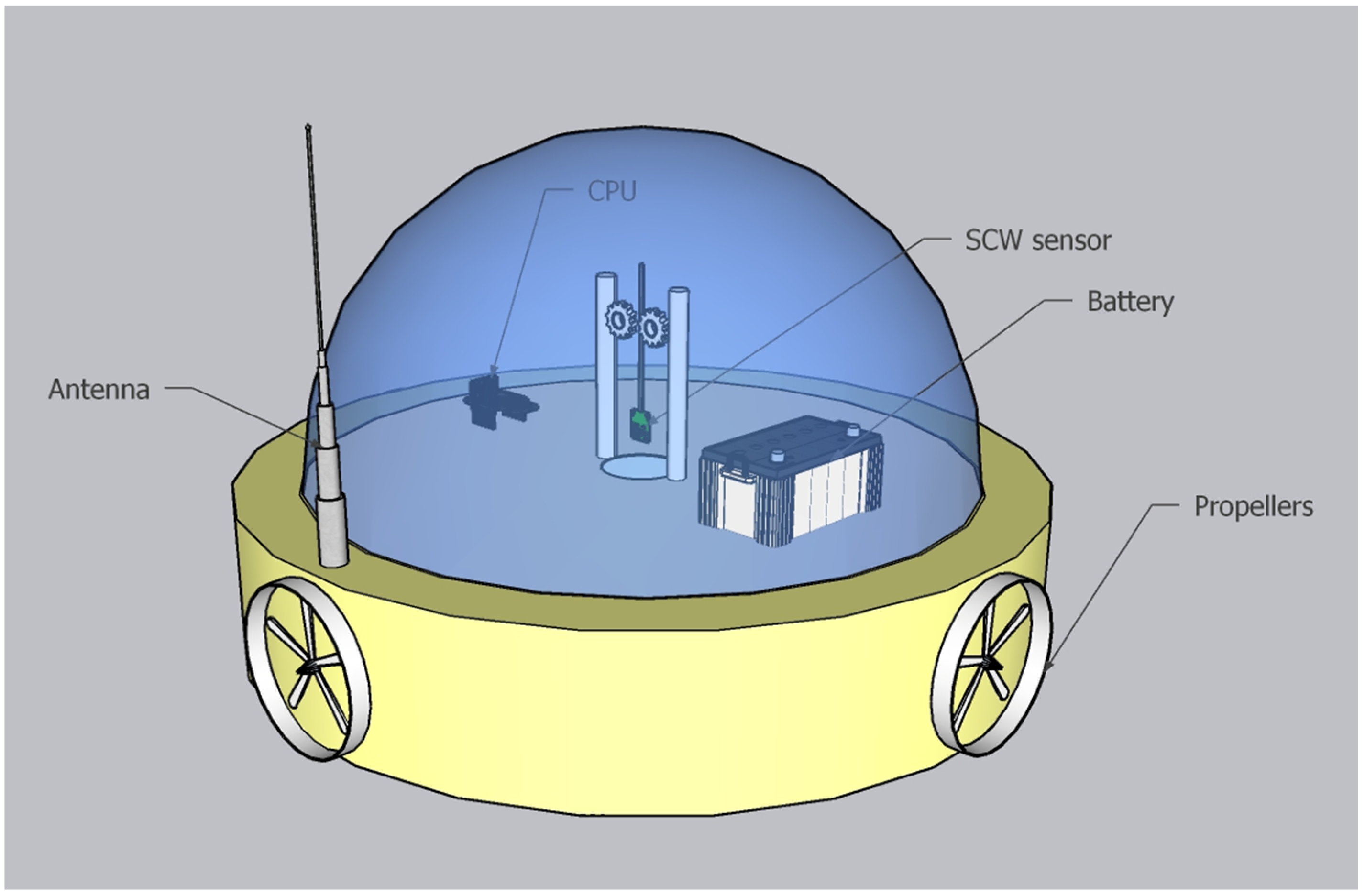
3. Autonomous Vehicles and Monitoring Platforms

Unmanned vehicles (UMVs) represent a significant innovation, improving the quality, affordability, and costs of environmental monitoring (Table 1). They are also used in the military field for the inspection of areas and targets of strategic interest [33], and they are divided into three kinds: AUVs, autonomous surface vehicles (ASVs), and remotely operated underwater vehicles (ROUVs). These vehicles can be also deployed in the air (unmanned aerial systems (UASs)), at the sea’s surface (ASVs, also known as unmanned surface vessels (USVs)), or in the water column (AUVs). UMVs have various applications, such as gathering oceanographic and meteorological data [34,35,36,37,38,39] and monitoring sea ice [40] and wildlife [41,42,43,44]. Most ROUVs are equipped with at least a video camera and lights. The main difference between these types is that an operator controls the ROUV, while AUVs and ASVs operate autonomously. Thus, some innovative vehicles are capable of sensing the environment and navigating on their own. UMVs include semi-submersibles and unmanned surface crafts.
The advantage, with respect to aerial photogrammetry and other large-scale monitoring approaches, is that the measures are quite direct, punctual, and characterized by precision and accuracy, even if large territories may be explored for longer times by smart AUVs. Their employment in association with other classical monitoring systems can increase accuracy and efficiency, because the movements of autonomous vehicles can be semi-randomly influenced by alarms sent by satellites or other monitoring sources, modifying the programmed maps of cruises. Such systems may also find wide application in critical coastal zones, such as in marine protected areas (MPAs), because they are left free to iteratively explore transects and continuously transfer to reference centers (on land) signals of “all normal” conditions or, alternatively, warning messages prompting immediate inspection by coastal guards or other marine authorities [45,46,47]. Several MPAs have been set in Europe in the last decade after the evaluation of marine sites of ecological interest [48], where ship transits are totally or partially forbidden, and consequently, oil spills should be avoided. Since continuous and punctual environmental monitoring in these areas is critical, automation of smart monitoring activities may represent an obvious solution.
AUVs are widely used for monitoring survey and data collection. They can be equipped with various types of sensors, such as sonar, video cameras, and the means for measuring conductivity, temperature, pressure, and salinity, among other factors. AUVs collect information through sensors. Parameters such as the water temperature and speed are simply measured and easily interpreted. Other types of data are more complex to collect and analyze because they require further interpretation to convert the records into meaningful information. Therefore, the selection of sensors is important for successful detection. Equally important is the diagnosis of the problem, which requires the ability to analyze and interpret the data collected by eliminating sensor noise and therefore making the data reliable [49,50,51,52]. They have the advantage of huge spatial coverage, but they are limited by a small resolution [53]. The risk is that the collected data might not be representative from a temporal point of view. As part of the research, they can be involved in data collection for bathymetric and magnetic fields and conformation of the seabed [54]. They are also used for the evaluation of water parameters in specific locations, such as in the areas surrounding hydrothermal processes or coral reefs [55]. Currently, they find application in various fields ranging from scientific research to industrial purposes. In industrial applications, AUVs are used for the monitoring and maintenance management of oil, gas ducts, and electrical lines [56]. Evidently, AUVs and ASVs represent the most recent advances in the field of smart tools compared with ROUVs, which were introduced several decades ago and have been improved in terms of efficiency and cost in the last few years. Additional equipment is commonly added to expand the vehicle’s capabilities. These may include sonars, magnetometers, a still camera, a manipulator or cutting arm, water samplers, and instruments that measure the water clarity, water temperature, water density, sound velocity, light penetration, and temperature [57].
ASVs and AUVs suitable for marine monitoring can vary from relatively small vehicles lifted by one or two persons and deployed from a small inflatable boat to large diesel-powered surface vessels [58]. In particular, smaller vessels are able to operate with a high level of autonomy and are also capable of staying at sea for several months. In contrast, larger surface vehicles often tend to be more tightly controlled. Surface vehicles have the advantage of being able to continuously receive GPS position data while navigating, and their locations can be accurately recorded at all times. Subsurface vehicles do not receive GPS data while they are immersed and therefore must generally rely on depth measurements and dead reckoning using electronic compasses [59,60]. Moreover, ASVs can operate safely in hazardous locations and at night and can cover much larger areas, mitigating the risk of crew fatigue. In some cases, they can independently operate off large ships [61].
ASVs started to be developed at an academic level in 1993, when the MIT presented its first vessel, called ARTEMIS [62,63]. The newer ASV, called the Shallow Water Autonomous Multipurpose Platform (SWAMP), is a full-electric catamaran built with the purpose of being a modular multi-functional vehicle, having several applications for a range of missions, such as geomorphological analysis, water sampling, and physical and chemical data collection in harsh environments [64]. This vehicle has four thrusters, azimuth pump-jet thrusters that are flush with the hull, small-draft soft foam, an unsinkable hull structure with high modularity, and a flexible hardware and software architecture [64]. Generally, USVs are associated with unmanned surface vehicles (USVs) [65]. Usually, USVs are equipped with a central processing unit and different memories for saving and providing a preliminary management of the acquired data (e.g., compression and classification). In addition, batteries and photovoltaic panels are equipped to increase the electrical autonomy as much as possible, which generally turns out to be one of the major limiting factors [60]. ENDURUNS is an example of a system that integrates both an AUV and an USV system. The USV is equipped to support the power requests of both systems with photovoltaic panels and rechargeable battery packs. The peculiarity of this AUV is the ability to move using two different modes. The first, thruster mode, allows it to move in a precise and controlled way to perform transects parallel to the seabed and collect data with great accuracy. The second mode is called glider mode and allows it to cover larger areas for a longer time, as consumption is significantly reduced [66,67,68]. The USV autonomously follows the AUV, providing information for accurate geo-localization of the acquired data. Data transfers between the AUV and the USV are realized through acoustics communication or through a wireless connection [53]. It is also important to establish threshold values at the beginning of the mission for correct data processing. The last phase is represented by adaptation, in which the mission plan can be redesigned by changing the detection scheme and the trajectory of the vehicle [69]. The AUTOSUB Long Range 1500, which is being designed, built, and operated by the National Oceanography Center, is a highly capable AUV with the potential of providing measurements that would have been previously impossible to collect, therefore allowing key advances in marine ecology studies. This vehicle will be built to be able to reach a depth of 1500 m [70,71].
Finally, an underwater “glider” (Table 1) is a specific type of AUV which employs variable-buoyancy propulsion instead of traditional propellers or thrusters. It houses sensors capable of making multidisciplinary oceanographic observations with long-term deployments (months) and has the ability to cover large distances (hundreds to thousands of kilometers) because it has significantly greater endurance compared with traditional AUVs [72]. The typical up-and-down, sawtooth-like profile followed by a glider can provide data on temporal and spatial scales unattainable by powered AUVs and which are much more costly to sample using traditional shipboard techniques. Four commercially available electric underwater gliders represent the main opportunities in this field: the Slocum electric [73], the Seaglider [34], the Coastal glider [74], and the Sea Explorer [75]. In addition, other gliders are under development, including Spray [76]. Coastal gliders are designed to be applied in the littoral zone (they are self-ballasting from essentially fresh to full ocean water) with a faster maximum speed (2 knots, according to Imlach and Mahr [74]). The Deep Glider, on the other hand, is designed to operate at depths of 6000 m [77]. These vehicles mostly extract energy from wave motion and convert it directly into forward motion. The vehicles also use solar or wind power to charge batteries used to power the navigation systems and the sensor payload.

4. Experimental Data

As mentioned above, the main advantage of coupling e-noses with smart autonomous vehicles relies on the possible customization of analytical procedures, as well as on the rapidity in intervention policies suddenly made possible after an accident or any type of pollution event. Attempts to quantify the ecological effects of special coastal areas, such as MPAs and MPA networks, are usually hampered by a lack of well-designed monitoring studies [78,79]. The management plans for an MPA network aim at protecting and conserving biodiversity and other natural values within protected areas. However, coastal monitoring in an MPA is not limited to the detection of oil pollution and the mapping of VOCs, because various ecological descriptors may be crucial to follow the chemical and physical state of key environments along the coastal waters in a timely manner [80,81], such as in seagrass meadows and recruitment areas. To this end, we designed and realized an innovative system for marine environmental monitoring whose main features are represented by the employment of an innovative probe carried aboard a smart ASV (Figure 2). Although the realization of the monitoring system is still in progress, it may be worth it to present the data obtained to date as a preliminary description of these innovative tools based on the newest technologies appearing on the market. In particular, we designed the prototype of a simple and inexpensive floating ASV able to independently move within an MPA located around the Isand of Ischia and send real-time data to a land-based station located at the local laboratory of Stazione Zoologica Anton Dohrn. The floating ASV was equipped with three electric propellers mounted under a floating plastic base, containing a glass bell that protected the main components. One of the main innovations was represented by the presence of pioneering probe technology.
The probe was a multi-metal detector produced by SensiChips [82], named “smart cable water” (SCW), based on the impedance generated by the presence of various pollutants. Such probes must be trained prior to be applied for ecological purposes, because their reactions to patterns of various substances are singular and not-linear. In this light, they represent a complex though interesting means to afford biomonitoring of coastal ecosystems. SCW is a multi-sensor microsystem (MSM) produced to monitor the presence of toxic chemicals (TICs), pollutants, hydrocarbons, and organics in water [83,84]. At the core of SCW there is SENSIPLUS, a microsensor platform which can interrogate on-chip and off-chip sensors with its versatile electrical impedance spectrometer (EIS) and potentiostat. Analyses performed with EIS allow for exploiting the RedOx dynamics of catalytic noble metals to aid the fine discrimination of chemicals along with the measurement of the conductivity and permittivity spectra. The on-chip potentiostat is used for a number of voltammetric or amperometric measurements and real-time discrimination of pollutants.
By cycling the electrodes with overvoltage, the device prevents or mitigates the formation of biofouling. Consequently, SCW may be considered a reliable multiparametric water analysis microsystem. Thanks to its analytical instruments and availability of catalytic interdigitated electrodes, SCW (Table 2) also represents an experimental microsystem for discriminative measurements (Figure 3).
As mentioned above, an SCW needs to be trained to recognize pollutants and other substances of ecological interest. For this purpose, various amounts of key compounds (such as nitrogen and phosphorus compounds) were tested and used to calibrate the probe. Our results indicate that low amounts of important pollutants were detected by the instrument, but a full set of permutated measurements is needed to train the instrument to recognize compounds in any pattern of reciprocal concentrations.
Another constraint is represented by the oxidizing power of the seawater, because continuous immersion in water rich in NaCl produces fast deterioration of some of the metal plates, drastically reducing the performance, as demonstrated by our tests. For this reason, the SCW was mounted over the ASV by means of an immersion device able to move the SCW up and down at various time intervals, protecting it with frequent washes in distilled water followed by mopping and drying of its surface. However, this SCW-equipped ASV was demonstrated to be quite promising for coastal monitoring, because its performance may improve through auto-training and also because of the easy installation over small smart vehicles wirelessly connected to the control stations on land.

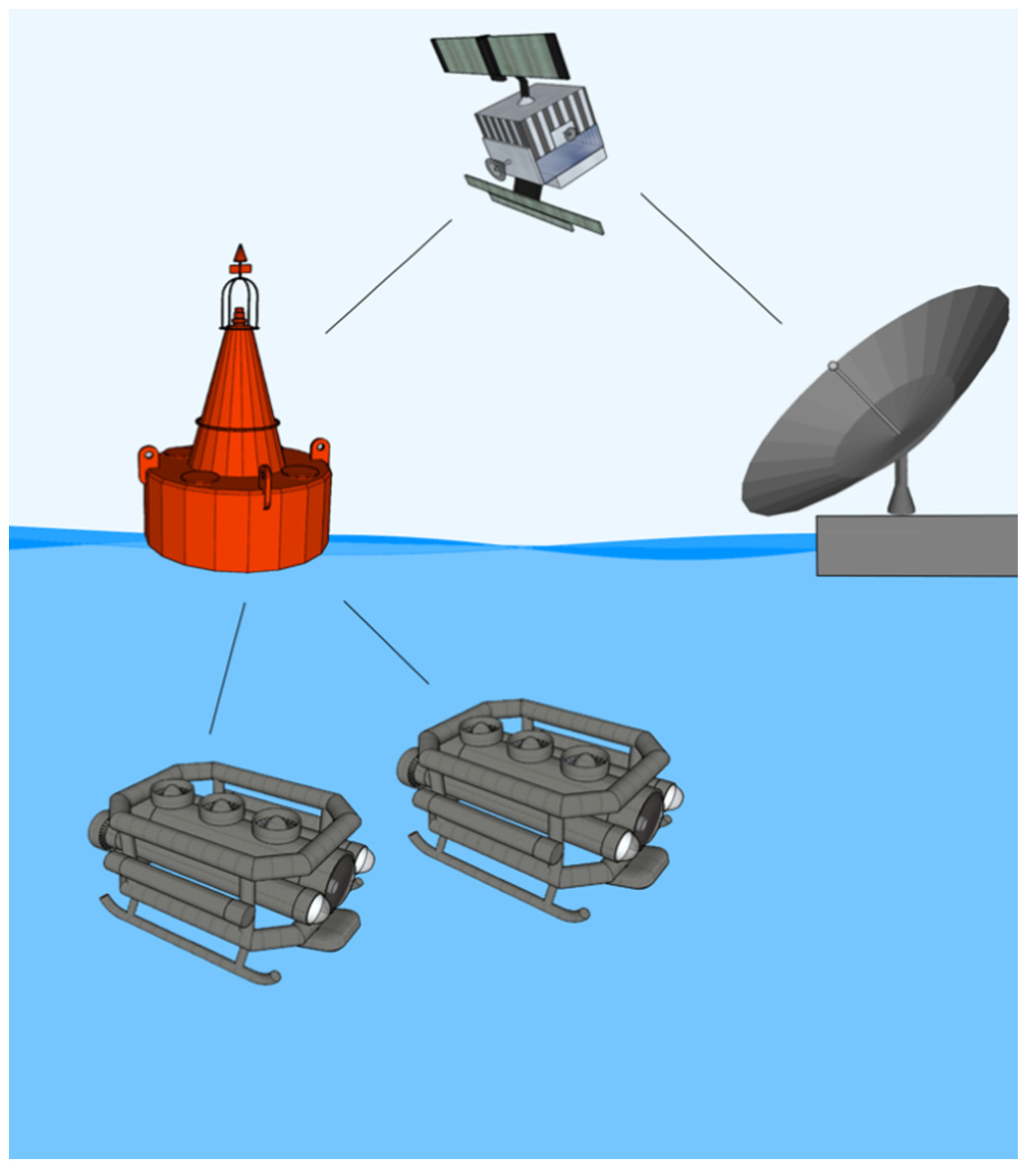
5. Autonomous Monitoring Networks

The increase in the exploitation of marine resources enforces the necessity to develop new methods of environmental monitoring which, with the integration of new technologies, make the reaching of new frontiers possible in the field of biological features, namely for environmental, physical, and chemical parameters and sampling surveys [85]. In fact, in recent years, several projects had the goal of identifying new tools for the optimization of monitoring and sampling techniques for the improved assessment of an environmental status, which is the basis of several international management policies [86,87]. The conception of new models of structures for data collection is necessary to cope with the different types of marine environments in which the survey is carried out to increase the operational range either in time or space [64]. While multiparametric cabled bases are a well-proven solution for the remote and continuous monitoring of marine environments [84], the implementation of more autonomous solutions is an important future prospect to ideally allow data collection at any depth and distance from the coast. In this light, network complementation with surface or aerial (radio frequency transmission) and underwater (acoustic) video monitoring may represent the smartest solution.
Video monitoring, in fact, can also be realized by taking advantage of a fixed-point cabled camera installed over a platform [88] or a mobile underwater television (UWTV) consisting of a towed camera sled. The sled is positioned on the seabed and dragged along a transept. Care must be taken to try to keep the vessel speed stable, as it is affected by the surface conditions [89]. The advantages of the UWTV solution lay in the fact that if used properly, it allows for obtaining a relatively constant measurement while being more accurate and less invasive than trawling surveys. For example, the Scottish government and Joint Nature Conservation Committee [90] considered the use of UWTVs an excellent solution to identifying any new areas potentially eligible to become MPAs [91].
Upon the set-up of various autonomous monitoring vehicles (AUVs), a network composed of AUVs moving around a single buoy may produce timely maps of the marine areas under control (Figure 4). The network should contain a master buoy equipped with a wireless link receiving data from the AUVs and, eventually, satellite communication to an inshore station in order to raise warning signals to the station as well as to check the real-time evolution of pollution events.

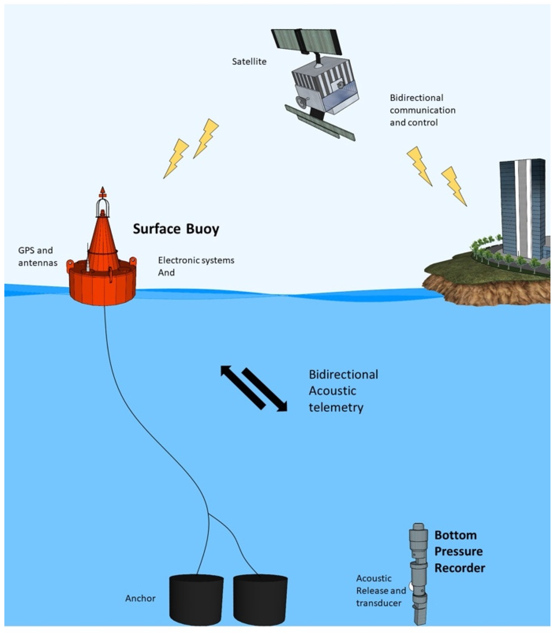
6. Marine Permanent Infrastructures

Currently, the largest existing networks of underwater observing stations are represented by permanent infrastructures specifically intended for multidisciplinary monitoring and research in the fields of geology, oceanography, and ecology. The advantage of permanent infrastructural networks is that they can be connected directly to the coast or through a succession of nodes [85,86]. Connection by a cable transmission line directly provides power and real-time data transmission to and from the marine observatory. However, networks of this magnitude are very expensive.
The operation costs for this kind of infrastructure are really high, considering the involvement of suitable ships and specialized equipment. Moreover, given the complexity and multidisciplinary nature of the projects, the use of specialized personnel is required in various areas, such as engineers, marine scientists, and data analysts [85,92]. Although the possibility of having a connection with the shore confers numerous advantages by finding an easy solution to the problems of energy supply and data transmission, at the same time, these prove to be a limit if the site of interest is not close enough to the coast [93]. Permanent structures tend to also be limited due to their restricted spatial coverage and unpredictable bias in monitoring results that can be influenced by the infrastructure’s presence [68]. To overcome these limitations, most of these infrastructures are integrated with mobile nodes that allow observations to be extended over a much larger area, taking into account different geographical gradients and different depths. A network designed by different nodes, including mobile ones, allows for collecting data in a more extensive and continuous way, making it possible to follow animal movement across different spatial gradients [94] and energy flux interchanges [95]. The data collected are transmitted through a cyber infrastructure, making it possible for anyone with an Internet connection to download the data in real time. Raw data are archived and read by a system code that separates them into data streams based on the content. According to the requirements, multiple levels of data products are processed with different algorithms to make them easier to consult at different levels of complexity. Each platform hosts several integrated scientific instruments, and they can contain multiple “nodes” to which the integrated instruments are attached, as well as a means for transmitting the data to the shore. Some examples of cabled observatories that integrate remote control systems and interactive sensors are the following.
The Ocean Networks of Canada (ONC) [96] is a research facility hosted and owned by the University of Victoria. This network operates with several ocean observatories in the deep ocean and coastal waters of Canada from the west and east coasts and the Arctic. It continuously collects data in real time, which are made available for scientific research, governments, and industry. Through the use of cabled observatories and remote-control systems, the ONC enables the development of several projects [97].
NEPTUNE is among the largest observatories. This observatory has several nodes, with various cabled instrument platforms and mobile crawlers that can cover around 15 km of linear distance with a depth oscillation of about 500 m [85]. This observatory is equipped with various instruments that can be used in different applications, such as a seismograph to monitor earthquake activity, bottom pressure recorders for real-time tsunami monitoring systems around the world, and specialized hydrophones to track marine mammals’ activities [98,99] and investigate how they are influenced by human activities. Specialized sensors, cameras, and remotely controlled sampling devices make NEPTUNE’s site easily adaptable for monitoring [98] commercially relevant fishery resources (such as the sablefish Anoplopoma fimbria) with life cycles that involve small-scale and large-scale geographic movements with both vertical and horizontal changes [100,101].
The American Ocean Observatory Initiative (OOI) funded by the National Science Foundation was designed as a long-term project to collect ocean data. The Ocean Observatories Initiative is made up of five major research components with several associated arrays located in the northern and southern Atlantic and Pacific according to the demand of the scientific community. Each array is composed of fixed and mobile platforms [102]. A platform can be stable, fixed, or mobile. Mobile components can move up and down in the water column or be a glider, which is able to move in three dimensions. Each platform hosts several integrated scientific instruments and can contain multiple “nodes” to which the integrated instruments are attached, as well as a means for transmitting the data to the shore. The OOI instrumentation is involved in the support of several research projects, including climate variability, ocean food webs, biogeochemical cycles, and coastal ocean dynamics and ecosystems.
The European Multidisciplinary Seafloor and water column Observatory (EMSO) [103] consists of a system of regional observatories located at key sites around Europe. Each platform is equipped with multiple sensors sited along the water column and on the seafloor. They constantly measure different parameters. Data are collected and available to different users, from scientists and industries to institutions and policy makers [104]. The EMSO infrastructure range runs at the European scale from the coastal area to the deep sea and open ocean, operating with both stand-alone observing systems and nodes connected to shore stations through fiber optic cable [105]. The data in both cases are transmitted in real time either through the cables or through acoustic networks featured by satellite-linked buoys [106]. Data are collected from the surface of the ocean to the seafloor. In addition to generic sensors, specific modules with different instrument combinations are deployed to be able to respond to specific objectives [107]. Many physical and biological applications require observation of the physical and ecological parameters (such as concentrations of oxygen and chlorophyll) at high-resolution time series data over long periods. Other systems for marine ecological research require photo and video imaging, acoustic recording, and in situ collections [65,66,67,68,69,70,71,72,73,74,75,76,77,78,79,80,81,82,83,84,85].
KM3NeT is a research infrastructure located in the Mediterranean Sea which houses the next-generation neutrino telescopes. Still nearing completion, this structure aims to have a detector volume of several cubic kilometers of clear seawater [108]. The main purpose of this project is to allow an innovative framework for studying neutrinos from distant astrophysical sources. Nonetheless, given the arrays of thousands of sensor modules, this research infrastructure will also house instrumentation for other scientific investigations for long-term and online monitoring that may find application in such fields as marine biology, oceanography, and geophysics [108].
The Joint European Research Infrastructure of Coastal Observatories (JERICO) is a network of coastal observatories providing a European Research Infrastructure (RI) dedicated to the observation and monitoring of marine coastal seas to provide high-quality environmental data as tools for scientific researchers and societal and policy needs [109,110]. It comprises JERICO-S3. In parallel, JERICO-RI is an integrated pan-European multidisciplinary and multi-platform research infrastructure dedicated to the assessment of changes in the coastal marine system. JERICO-S3 officially started in 2020, entitled Marine coastal observatories, facilities, expertise, and data for Europe. Its aim is to be involved in the cooperation of coastal observatories in Europe by the implementation and improvement of the coastal structures of a European Ocean Observing System and to cooperate with other European initiatives. There are currently 10 structures between the different partner nations. These facilities provide wired observatories, AUVs, fixed and multi-platform structures, and calibration laboratories to allow the carrying out of different projects [111]. An example of some of these projects currently underway is the study focused on Algerian Basin (AB) circulation through the monitoring line ABACUS [112] through the AB between Palma de Mallorca and the southern part of the basin [113]. These projects involve partners both public (e.g., university and research institutes) and private (e.g., private non-profit research institutes) from European and non-European countries.

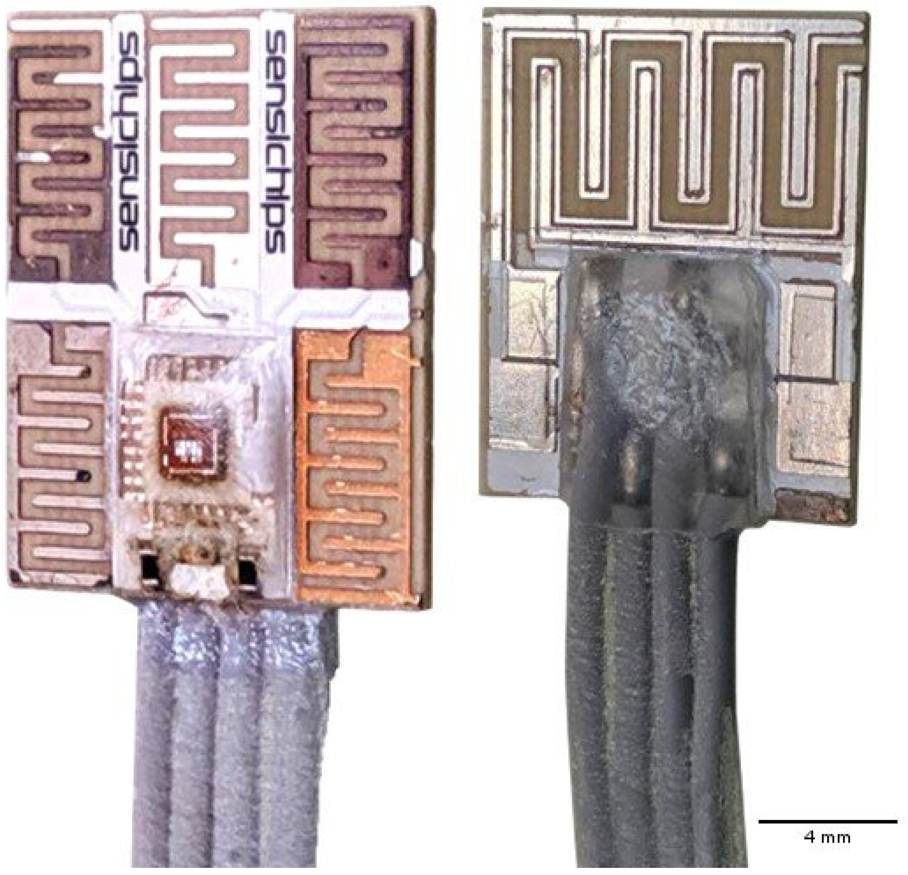
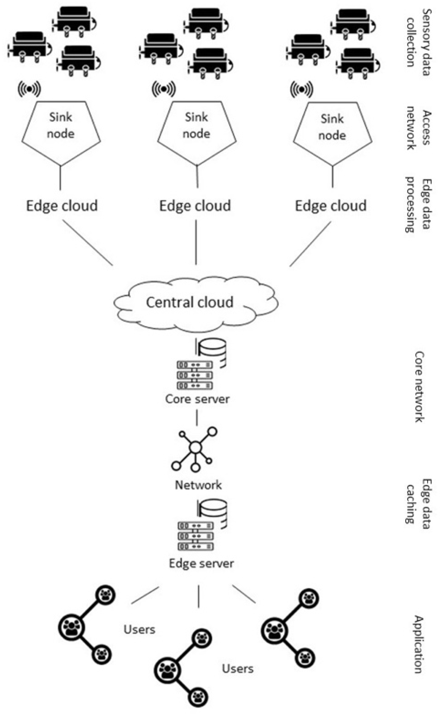
7. IoT Hardware Modules

The European Research Cluster of the Internet of Things defined the IoT as a technological revolution, consisting of a dynamic global network infrastructure with self-configuring capabilities. It is based on standard and interoperable communication protocols. In this system, physical and virtual “things” have identities, physical attributes, and virtual personalities, and they use intelligent interfaces natively integrated into an information network [114]. The IoT is characterized by the integration of various devices equipped with sensing, identification, processing, communication, actuation, and networking capabilities [115] (Figure 5).
The term Internet of Things was initially created in 1999 by Kevin Ashton, an expert in digital innovation [117]. IoTes (i.e., the “objects” taking part of the network) can be variously defined. Firstly, IoTes can be defined as intelligent objects, or “things having identities and virtual personalities” operating in smart spaces and using intelligent interfaces to connect and communicate within social, environmental, and user contexts [118]. IoTes are also considered an extension of the Internet with objects, devices, sensors, and items not ordinarily considered computers [119]. In addition, the IoT is understood as a global network infrastructure linking physical and virtual objects (IoTes) through the exploitation of data capture and communication capabilities [120]. Finally, the IoT can be regarded as a way to promote information interaction by linking people, things, and objects autonomously and intelligently without any temporal or spatial constraints [121,122].
Even if the IoT and IoTes are still evolving, their effects are beginning to be seen and are making great strides, offering universal solution media for an interconnected scenario [123]. This is mainly due to the fact that the IoT guarantees high-speed and accurate data with secure processing and an improved client or user experience [124,125]. Its development depends on dynamic technical innovation in a number of important fields, from wireless sensors to nanotechnology [126]. In fact, the IoT can be applied to various fields of our daily life, such as eHealth (a relatively recent health care practice supported by electronic processes and communication) [127], security, entertainment, smart cities, defense, and many other fields [128]. The IoT can be used to manage soil moisture, irrigation and drainage systems, and crops in smart farming systems. Finally, the IoT is useful to monitor the conditions of marine environments, allowing scientists to monitoring such physical parameters as the water temperature, dissolved oxygen, salinity, pH, and turbidity [129]. Smart health sensors are used to collect human physiology information as well and use gateways and clouds to analyze and store the information and wirelessly send the analyzed data to caregivers for further analysis and review [130]. The IoT can also be operated in smart cities for (1) improving infrastructure, public transportation [125], and electrical conductivity thanks to smart grids that combine the information and communications technologies into an electricity network [131] and (2) helping predict natural disasters with the combination of sensors and their autonomous coordination and simulation [132]. However, the IoT is not limited to public uses. It can also be privately adopted for smart home and security systems, such as by natively connecting several household devices to the Internet [133].
Domingo [134] proposed the architecture of an IoT network in three layers: (1) perception, (2) network, and (3) application. The main function of the perception layer is to identify specific objects and gather information. It is formed mainly by sensors, actuators, monitoring stations (such as cell phones, tablet PCs, smart phones, and PDAs), nano-nodes, RFID tags, and readers and writers. Depending on the type of sensor, the information to be referred can be the location, temperature, orientation, motion, vibration, acceleration, humidity, or chemical changes, among other details. The collected information is then passed to the network layer for its secure transmission to the information processing system. This network layer consists of converging, privately owned, wired, or wireless networks where the transmission technology can be chosen (e.g., 3G, UMTS, Wi-fi, Bluetooth, infrared, or ZigBee) depending upon the features of sensor devices. Its main function is to transfer the information obtained from the perception layer to the middleware layer. It receives the information from the network layer, stores it in the database, and autonomously makes some decisions based on the results and the agreed protocols. The application layer provides global management based on the object’s information processed in the middleware layer. Finally, the business layer is responsible for the overall management of the IoT system, including applications and services. In particular, this layer eventually builds management models, graphs, and flowcharts, and it proposes the future actions and operative strategies based on the data received from the application layer [132].
Evidently, the IoT represents a future challenge in many technological applications, minimizing efforts, offering the use of efficient resources, and guaranteeing accurate quality data and a high speed of reaction. The reliability and validity of the data, performance, security, and privacy are additional advantages. However, various issues will need to be addressed in the future, such as privacy issues (hackers can break into the system and steal the data) and unemployment, because some activities performed by human operators will be replaced by machines [125,133].

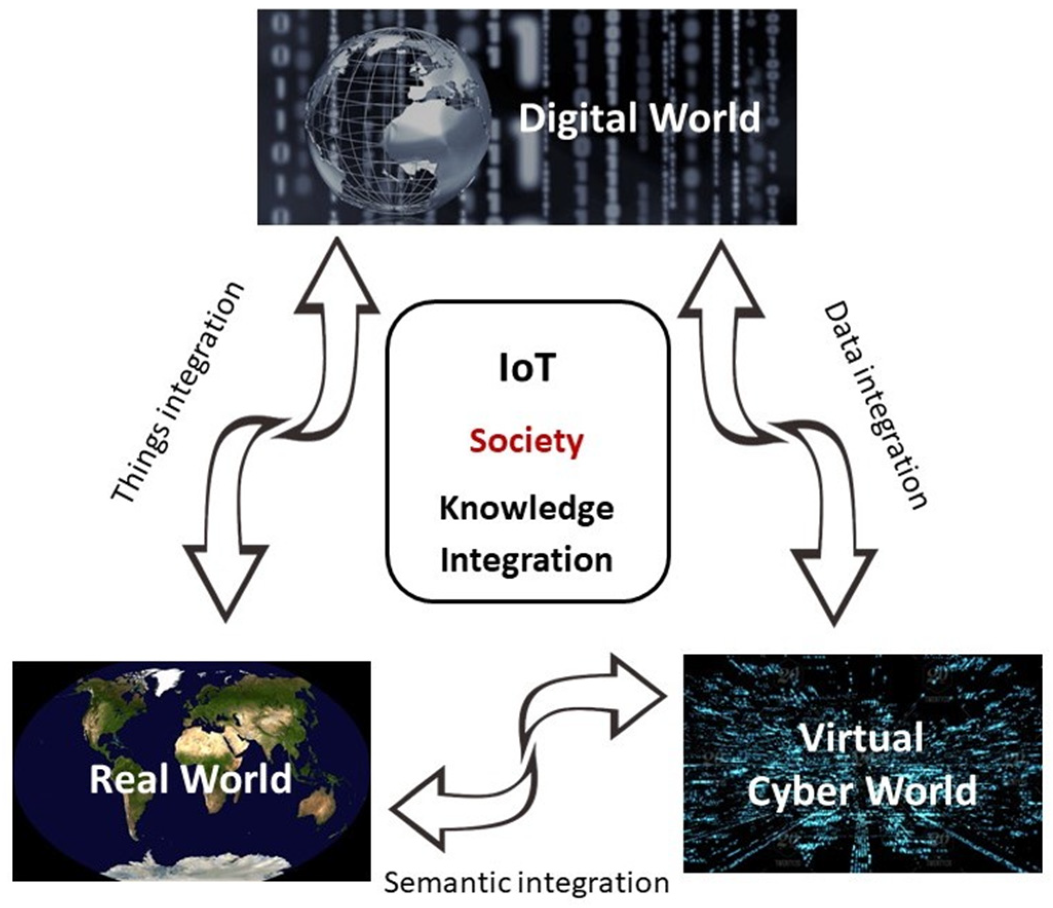
8. The IoT Applied to Marine Environmental Monitoring

IoT-based technologies, as well as wireless sensor networks (WSNs), a subset of IoT, can be applied to the monitoring and protection of marine environments [13]. In particular, monitoring activities employing IoT technology can be used for ocean sensing and monitoring of water quality [134], coral reef protection, offshore and deep-sea fish farms, and wave and current watching [13].
The development of an adaptive, scalable WSN must foresee such critical properties as autonomy, scalability, adaptability, durability, and simplicity [135]. On the other hand, the design and deployment of a lasting and scalable WSN for marine environment monitoring should consider all of the following peculiar challenges mentioned in the second paragraph. Other issues can concern the devices and sensor nodes, which can be highly reliable because of the difficult deployment and maintenance. In addition, their coverage needs to be carefully evaluated, because their application over large areas far from direct control and with expensive, delicate equipment should be protected against possible acts of vandalism [13,135].
Overall, an online marine monitoring system needs (1) sensors adequate to measure seawater features, (2) a controller or processor unit to compute the data from sensors, and (3) communication equipment to send data from the processing unit to the cloud via ground stations. Sending large amounts of data (as large images or videos) to the cloud requires the combination of the IoT and cloud computing, because satellite communications may be expensive, in terms of both money and energy consumed [136,137] (Figure 6), and sensing stations should be relatively small and light.

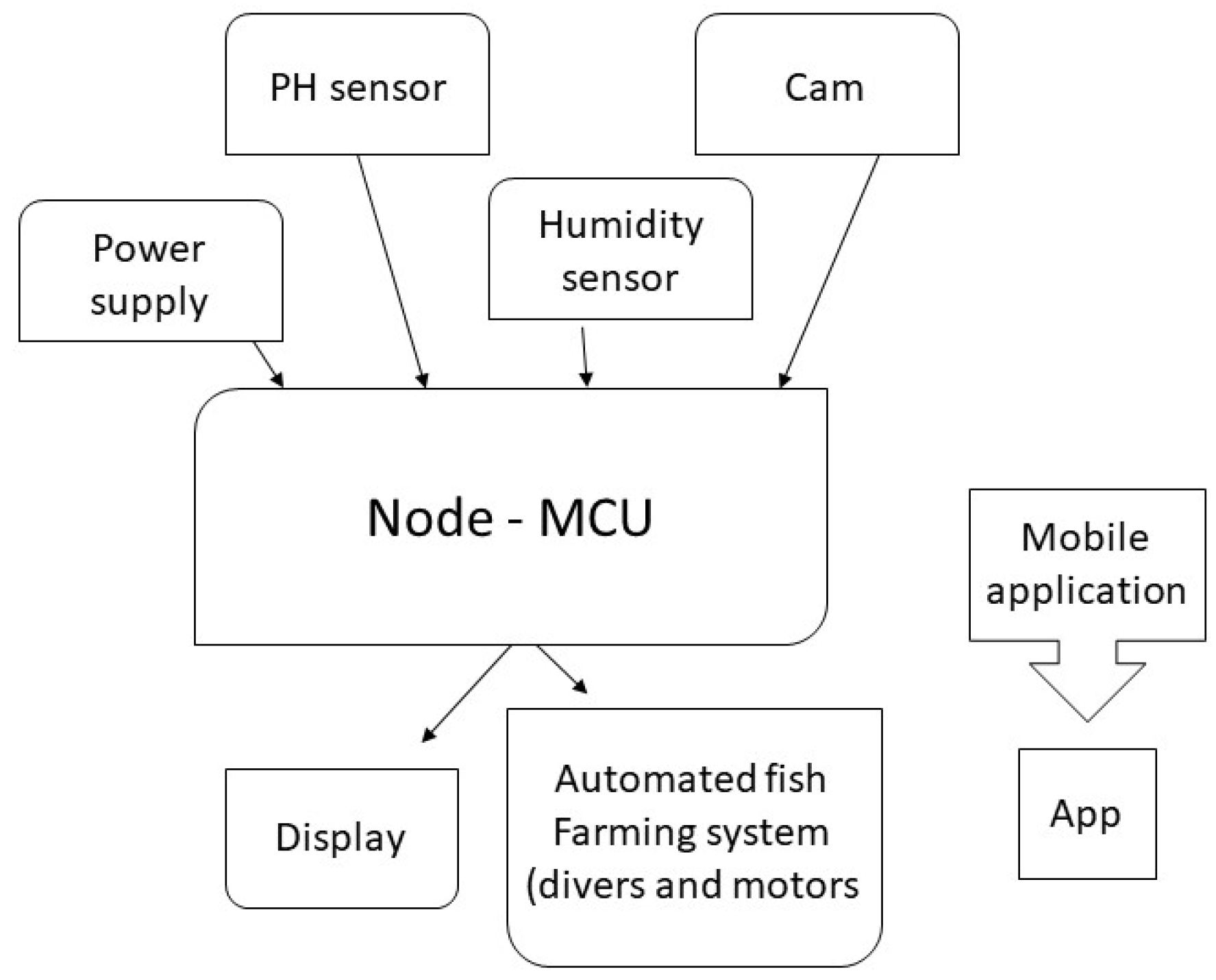
9. Monitoring Applied to Aquaculture and Fishery Productions

Various technological applications of artificial intelligence (AI) were set for improving the sustainability of monitoring in coastal waters and oceans, as well as in aquaculture and smart fishery plants, and they are widespread nowadays [138]. In particular, the attention of scientists in AI-inspired fisheries focused mostly on monitoring the automation of fishery resources (mainly detection, identification, and classification). However, it is still unclear how fishers perceive AI needs and how governments exhibit a tangible strategy on the regulation of AI concerning smart fishery systems to promote the value and potential of the techniques of AI-inspired fisheries. AI has great influence on catch monitoring across fishery systems at sea [139], and several AI applications improved fishing activities, helping the economic evaluation of commercial fleets [140]. In addition, a fishery may be helped by electronic monitoring of the catch and bycatch [141], as well as the detection and forecasting of fishing grounds [142], eventually applying mathematical models to simulate fishing vessel behavior [143]. This also helps to reduce fishery wastes [144] by optimizing the sorting operations. Finally, automation of the monitoring of illegal fishery methods [145] is also possible for reducing the negative impacts of fisheries on coastal areas. The AI technologies of fish farming mainly focus on the means for optimizing the efficient use of resources in ecosystem management [146]. In several instances, fishery and ecological monitoring have been strictly interconnected. In fact, sustainable fisheries are related to environmental monitoring [147]. Various authors stressed the scope of smart fisheries because of the “epidemic of plastics entering the sea”. This warrants urgent action if humanity is to stave off a collapse in fish stocks. Additionally, oil spills [148] and global changes [149], as mentioned above, are topics of great concern [150], prompting not only issues of environmental conservation but also large impacts on fisheries [151], requiring accurate and modern monitoring activities. The employment of smart systems able to autonomously tune their activities according to local perturbations and able to be trained for the detection of various compounds (both in the water and over the water, evolving into e-noses) is boosting improvements in various fields of environmental monitoring.
A special case of monitoring marine environments is the one applied to aquaculture activities [152,153], primarily because these activities may impact various coastal areas when practiced in cages, pens, floating tanks, and raceways deployed in open waters [154]. There is great concern about the potential environmental effects of marine finfish cages on the water quality [155] and a large interest in developing an ecologically responsible industry [156,157]. Several reviews [158] have broadly addressed this topic [159,160,161].
In addition, aquaculture ponds may be considered very special marine environments, and they need continuous monitoring and real-time reactions to negative changes impacting the organisms contained therein [162]. In addition, in this case, artificial intelligence and IoT devices may be applied to improve production efficiency and reduce impacts and risks. In fact, the connection between good environmental conditions and seafood health in aquaculture has been documented [163,164,165]. Sea cages can be more than 45 m in diameter and 30 m deep, and they need frequent inspections. Although a single cage can contain high value production [166,167], the level of surveillance of the product and of the closer environments is often low [168]. As for tank aquaculture, various remote sensor systems were proposed to have a conveyed gathering of sensor hubs organized together and be able to exchange the crude information up to a base station through an IoT network [169,170]. Using Arduino-like hardware and a few simple probes, automatic farming systems were developed based on IoT platforms (Figure 7).
All IoT systems for aquaculture are to be considered smart systems based on intelligent sensors, intelligent processing, and intelligent control. Their functions consist of data collection, real-time image acquisition, wireless transmission, intelligent processing, warning messages, and auxiliary decision making [171,172,173]. Any aquaculture IoT monitoring system fundamentally consists of water quality monitoring stations, including meteorological stations, water quality control stations, and on-site and remote monitoring centers. These structures are supported by a central cloud-processing platform [174]. The water monitoring stations are provided with monitoring sensors and take advantage of wireless data collection terminals. Local data are collected in ponds and transmitted to monitoring centers. In particular, such water quality parameters as dissolved oxygen, pH, and ammonia concentration are key elements to allow prompt answers to production issues. Generally, weather stations are also used to acquire in real time such meteorological data as wind speed, wind direction, and air humidity. The system analyzes the relationships between the water quality parameters and weather changes to predict water quality trends and ensure the optimal water quality in the culture tanks. The tank controllers include independent control terminals, an electrical control box, aerators, and other equipment, with the control terminal receiving wireless instruction from the control equipment. On-site and remote monitoring centers based on wireless sensor networks and the Global System for Mobile Communications (GSM) central servers with central cloud processing platforms are included, favoring an intelligent control algorithm for water quality to achieve data acquisition, smart data processing, alarms, and their mailing to human managers [175]. Central cloud processing platforms provide the basis for decision making for farmers by providing a variety of models and algorithms of quality monitoring, feeding, and pond management [176]. These strategies reduce the risks of product losses, reduce the pollution of local environments by increasing the efficiency of culture procedures, and also reduce the need for using drugs, with obvious advantages for local environments.

10. Conclusions

Environmental monitoring solutions must be adapted to each individual situation, because communication systems and the rapidity of responses differently influence the monitoring activities in various environments. Evidently, pollution is concentrated off the coastal areas [177], where anthropized urban settlements are mainly located and maritime traffic is intense [178]. In the case of the Mediterranean, for example, which is almost completely surrounded by lands, ecosystems may be extremely fragile and vulnerable because their waters are slowly renewable, thus making them sensitive to all kinds of pollutants, especially when derived from commercial traffic, industrial pollution, or touristic activities [179]. In parallel, these areas are characterized by valuable and fragile environments such as seagrass meadows and coralligenous areas [180,181], and they deserve a higher degree of monitoring and conservation practices [182]. This task is partially accomplished by the institution of MPAs and sanctuaries, but again, they require a higher level of monitoring and immediate reaction to stresses produced by anthropic activities in order to conserve key reproductive areas and fragile environments [183,184]. In this case, communications are not the most important problem, since the presence of coasts closer to the monitoring areas guarantee a fast transfer of information to the computing centers [176]. In contrast, oil pollution has become a matter of serious environmental concern in all oceans [26], with petroleum hydrocarbons (gasoline, kerosene, fuel oil, etc.) penetrating shallow and deeper environments through spills or leaks, as well as after frequent accidents [27]. Here, the rapid delivery of signals becomes critical because coastal stations are quite far away, and satellite communications become indispensable.
An ocean-sensing and monitoring network is a monitoring system that has basically been applied since the last century because oceanographic and hydrographic research vessels were previously adopted for this purpose. A water quality monitoring system usually monitors water conditions and quality, including water temperature, pH, turbidity, conductivity, and dissolved oxygen (DO) in bays, lakes, rivers, and other water bodies. A coral reef monitoring system typically monitors coral reef habitats and the surrounding environments. A marine fish farm monitoring system checks water conditions and quality, including the temperature and pH. It measures the levels of waste and uneaten feed in a fish farm, as well as fish conditions and activities including the presence of dead fish. A wave and current monitoring system measures waves and currents for safe and secure waterway navigation [13]. The most common tools traditionally used to monitor marine environments are satellite imagery, underwater devices with various sensors, and buoys [184]. These devices transmit data by means of satellite communications or close-range base stations, which present several limitations and elevated infrastructure costs. Unmanned aerial vehicles (UAVs), as described above, are an alternative for remote environmental monitoring which provides new types of data and ease of use. These techniques are mainly used in video capture-related applications in its various light spectra and do not provide the same data as sensing buoys, nor can they be used for extended periods of time [184]. However, it is important to stress that monitoring the marine environment is quite challenging, because it requires waterproof robust technology to endure the high levels of humidity and salinity, wave collisions, and extreme weather conditions [135].
In this light, the development of newer “noses”, coupled with the powerful features of various kinds of UMVs as classified above, may represent a tremendous innovation toward the collection of data in an efficient way, with minimum costs and fast delivery of strategic information. In this review, we have described, from an historical perspective, the main strategies of monitoring coastal and ocean areas, showing that several smart solutions are presently available, although most of them still need complete engineering to reach full applicability, perfect automation, and their best performance.

Author Contributions

Conceptualization, M.C. and V.Z.; methodology, F.G., F.E.; software, F.G., L.G., A.R., M.M., P.B. and R.E.; formal analysis, V.Z. and F.G.; resources, M.C., V.Z., F.E.; data curation, M.C.; writing—original draft preparation, F.G., M.C. and V.Z.; writing—review and editing, V.Z. and M.C.; supervision, A.D.C., M.C. and V.Z. All authors have read and agreed to the published version of the manuscript.

Funding

This research received no external funding.

Institutional Review Board Statement

Ethical review and approval are not applicable for this review.

Informed Consent Statement

Not applicable.

Data Availability Statement

Not applicable.

Acknowledgments

SENSIPLUS is a microsensor platform developed by Sensichips.

Conflicts of Interest

The authors declare no conflict of interest.

References

  1. Chuaysi, B.; Kiattisin, S. Fishing Vessels Behavior Identification for Combating IUU Fishing: Enable Traceability at Sea. Wirel. Pers. Commun. 2020, 115, 2971–2993. [Google Scholar] [CrossRef]
  2. Al-Absi, M.A.; Kamolov, A.; Al-Absi, A.A.; Sain, M.; Lee, H.J. IoT Technology with Marine Environment Protection and Monitoring. In International Conference on Smart Computing and Cyber Security; Springer: Singapore, 2021; pp. 81–89. [Google Scholar]
  3. DONET System Concept. Available online: https://www.jamstec.go.jp/donet/e/ (accessed on 16 January 2022).
  4. González, F.I.; Milburn, H.B.; Bernard, E.N.; Newman, J. Deep-Ocean Assessment and Reporting of Tsunamis (DART®): Brief Overview and Status Report. In Proceedings of the International Workshop on Tsunami Disaster Mitigation, Tokyo, Japan, 19 January 1998; pp. 19–22. [Google Scholar]
  5. Meinig, C.; Stalin, S.; Stalin, S.E.; Nakamura, A.I.; Milburn, H.B. Real-Time Deep-Ocean Tsunami Measuring, Monitoring, and Reporting System: The NOAA DART II Description and Disclosure; NOAA: Washington, DC, USA, 2005. [Google Scholar]
  6. Tonacci, A.; Lippa, M.A.; Pioggia, G.; Domenici, C.; Lacava, G.; Lupi, L.; Gualdesi, L.; Cocco, M. A Smart Multimodal Innovative Model For Marine Environmental Monitoring. In Proceedings of the 29th European Conference on Modelling and Simulation ECMS, Albena, Bulgaria, 26–29 May 2015; pp. 455–461. [Google Scholar]
  7. Milburn, H.B.; Nakamura, A.I.; Gonzalez, F.I. Real-Time Tsunami Reporting from the Deep Ocean. In Proceedings of the Oceans Conference Record (IEEE), Lauderdale, FL, USA, 3–26 September 1996; Volume 1, pp. 390–394. [Google Scholar]
  8. Kim, S.; Lee, W.; Kwon, H.; Kim, J. Design and Preliminary Implementation of an IoT-Based System for Ocean Observation Buoys. In Proceedings of the ITC-CSCC, Okinawa, Japan, 10 July 2016; pp. 865–867. [Google Scholar]
  9. Kim, S.M.; Lee, U.H.; Kwon, H.J.; Kim, J.Y.; Kim, J. Development of an IoT Platform for Ocean Observation Buoys. IEIE Trans. Smart Process. Comput. 2017, 6, 109–116. [Google Scholar] [CrossRef]
  10. Boonma, P.; Suzuki, J. An Adaptive, Scalable and Self-Healing Sensor Network Architecture for Autonomous Coastal Environmental Monitoring. In Proceedings of the IEEE Conference on Technologies for Homeland Security, Woburn, MA, USA, 16–17 May 2007; p. 18. [Google Scholar]
  11. Albaladejo, C.; Sánchez, P.; Iborra, A.; Soto, F.; López, J.A.; Torres, R. Wireless Sensor Networks for Oceanographic Monitoring: A Systematic Review. Sensors 2010, 10, 6948–6968. [Google Scholar] [CrossRef] [PubMed]
  12. Hadim, S.; Mohamed, N. Middleware: Middleware Challenges and Approaches for Wireless Sensor Networks. IEEE Distrib. Syst. Online 2006, 7, 1–23. [Google Scholar] [CrossRef]
  13. Xu, G.; Shi, Y.; Sun, X.; Shen, W. Internet of Things in Marine Environment Monitoring: A Review. Sensors 2019, 19, 1711. [Google Scholar] [CrossRef] [Green Version]
  14. Alippi, C.; Camplani, R.; Galperti, C.; Roveri, M. Effective Design of WSNs: From the Lab to the Real World. In Proceedings of the 3rd International Conference on Sensing Technology, ICST 2008, Taipei, Taiwan, 30 November–3 December 2008; pp. 1–9. [Google Scholar] [CrossRef]
  15. Cardei, M.; Wu, J. Energy-Efficient Coverage Problems in Wireless Ad-Hoc Sensor Networks. Comput. Commun. 2006, 29, 413–420. [Google Scholar] [CrossRef] [Green Version]
  16. Alpers, W.; Hühnerfuss, H. The Damping of Ocean Waves by Surface Films: A New Look at an Old Problem. J. Geophys. Res. Ocean. 1989, 94, 6251–6265. [Google Scholar] [CrossRef]
  17. Topouzelis, K.; Karathanassi, V.; Pavlakis, P.; Rokos, D. Detection and Discrimination between Oil Spills and Look-Alike Phenomena through Neural Networks. ISPRS J. Photogramm. Remote Sens. 2007, 62, 264–270. [Google Scholar] [CrossRef]
  18. Van der Meer, F.; Jong, S. De Imaging spectrometry: Basic principles and prospective applications. In Basic Principles of Imaging Spectrometry; Kluwer Academic: Alphen aan den Rijn, The Netherlands, 2001; pp. 21–23. [Google Scholar]
  19. Martins, F.; Leitão, P.; Silva, A.; Neves, R. 3D Modelling in the Sado Estuary Using a New Generic Vertical Discretization Approach. Oceanol. Acta 2001, 24, 51–62. [Google Scholar] [CrossRef] [Green Version]
  20. Tonacci, A.; Corda, D.; Tartarisco, G.; Pioggia, G.; Domenici, C. A Smart Sensor System for Detecting Hydrocarbon Volatile Organic Compounds in Sea Water. CLEAN–Soil Air Water 2015, 43, 147–152. [Google Scholar] [CrossRef]
  21. Bourgeois, W.; Stuetz, R.M. Use of a Chemical Sensor Array for Detecting Pollutants in Domestic Wastewater. Water Res. 2002, 36, 4505–4512. [Google Scholar] [CrossRef]
  22. Sobański, T.; Szczurek, A.; Nitsch, K.; Licznerski, B.W.; Radwan, W. Electronic Nose Applied to Automotive Fuel Qualification. Sens. Actuators B Chem. 2006, 116, 207–212. [Google Scholar] [CrossRef]
  23. Pieri, G.; Cocco, M.; Salvetti, O. A Marine Information System for Environmental Monitoring: ARGO-MIS. J. Mar. Sci. Eng. 2018, 6, 15. [Google Scholar] [CrossRef] [Green Version]
  24. Moroni, D.; Pieri, G.; Tampucci, M.; Salvetti, O. Environmental Monitoring Integrated with a Proactive Marine Information System. Proceedings 2018, 2, 98. [Google Scholar] [CrossRef] [Green Version]
  25. Tonacci, A.; Lacava, G.; Lippa, M.A.; Lupi, L.; Cocco, M.; Domenici, C. Electronic Nose and AUV: A Novel Perspective in Marine Pollution Monitoring. Mar. Technol. Soc. J. 2015, 49, 18–24. [Google Scholar] [CrossRef]
  26. Ines, Z.; Amina, B.; Mahmoud, R.; Dalila, S.-M. Aliphatic and Aromatic Biomarkers for Petroleum Hydrocarbon Monitoring in Khniss Tunisian-Coast, (Mediterranean Sea). Procedia Environ. Sci. 2013, 18, 211–220. [Google Scholar] [CrossRef] [Green Version]
  27. Mille, G.; Asia, L.; Guiliano, M.; Malleret, L.; Doumenq, P. Hydrocarbons in Coastal Sediments from the Mediterranean Sea (Gulf of Fos Area, France). Mar. Pollut. Bull. 2007, 54, 566–575. [Google Scholar] [CrossRef]
  28. Marcelli, M.; Piermattei, V.; Gerin, R.; Brunetti, F.; Pietrosemoli, E.; Addo, S.A.M.; Boudaya, L.; Coleman, R.; Nubi, O.A.; Jojannes, R. Toward the Widespread Application of Low-Cost Technologies in Coastal Ocean Observing (Internet of Things for the Ocean). Mediterr. Mar. Sci. 2021, 22, 255–269. [Google Scholar] [CrossRef]
  29. Derycke, S.; Remerie, T.; Vierstraete, A.; Backeljau, T.; Vanfleteren, J.; Vincx, M.; Moens, T. Mitochondrial DNA Variation and Cryptic Speciation within the Free-Living Marine Nematode Pellioditis Marina. Mar. Ecol. Prog. Ser. 2005, 300, 91–103. [Google Scholar] [CrossRef] [Green Version]
  30. Sogin, M.L.; Morrison, H.G.; Huber, J.A.; Welch, D.M.; Huse, S.M.; Neal, P.R.; Arrieta, J.M.; Herndl, G.J. Microbial Diversity in the Deep Sea and the Underexplored “Rare Biosphere”. Proc. Natl. Acad. Sci. USA 2006, 103, 12115–12120. [Google Scholar] [CrossRef] [Green Version]
  31. Danovaro, R.; Gambi, C.; Dell’Anno, A.; Corinaldesi, C.; Fraschetti, S.; Vanreusel, A.; Vincx, M.; Gooday, A.J. Exponential Decline of Deep-Sea Ecosystem Functioning Linked to Benthic Biodiversity Loss. Curr. Biol. 2008, 18, 1–8. [Google Scholar] [CrossRef] [PubMed]
  32. Danovaro, R.; Snelgrove, P.V.R.; Tyler, P. Challenging the Paradigms of Deep-Sea Ecology. Trends Ecol. Evol. 2014, 29, 465–475. [Google Scholar] [CrossRef] [PubMed]
  33. Aguado, E.; Milosevic, Z.; Hernández, C.; Sanz, R.; Garzon, M.; Bozhinoski, D.; Rossi, C. Functional Self-Awareness and Metacontrol for Underwater. Robot Autonomy. Sensors 2021, 21, 1210. [Google Scholar] [CrossRef] [PubMed]
  34. Eriksen, C.C.; Osse, T.J.; Light, R.D.; Wen, T.; Lehman, T.W.; Sabin, P.L.; Ballard, J.W.; Chiodi, A.M. Seaglider: A Long-Range Autonomous Underwater Vehicle for Oceanographic Research. IEEE J. Ocean. Eng. 2001, 26, 424–436. [Google Scholar] [CrossRef] [Green Version]
  35. Funaki, M.; Hirasawa, N. Outline of a Small Unmanned Aerial Vehicle (Ant-Plane) Designed for Antarctic Research. Polar Sci. 2008, 2, 129–142. [Google Scholar] [CrossRef] [Green Version]
  36. Leong, S.C.Y.; Tkalich, P.; Patrikalakis, N.M. Monitoring Harmful Algal Blooms in Singapore: Developing a HABs Observing System. In Proceedings of the Program Book-OCEANS 2012 MTS/IEEE Yeosu: The Living Ocean and Coast-Diversity of Resources and Sustainable Activities, Yeosu, Korea, 21–24 May 2012. [Google Scholar] [CrossRef]
  37. Meyer, D. Glider Technology for Ocean Observations: A Review. Ocean. Sci. Discuss. 2016, 40, 1–26. [Google Scholar] [CrossRef]
  38. Williams, S.B.; Pizarro, O.; Webster, J.M.; Beaman, R.J.; Mahon, I.; Johnson-Roberson, M.; Bridge, T.C.L. Autonomous Underwater Vehicle–Assisted Surveying of Drowned Reefs on the Shelf Edge of the Great Barrier Reef, Australia. J. Field Robot. 2010, 27, 675–697. [Google Scholar] [CrossRef]
  39. Wynn, R.B.; Huvenne, V.A.I.; Le Bas, T.P.; Murton, B.J.; Connelly, D.P.; Bett, B.J.; Ruhl, H.A.; Morris, K.J.; Peakall, J.; Parsons, D.R.; et al. Autonomous Underwater Vehicles (AUVs): Their Past, Present and Future Contributions to the Advancement of Marine Geoscience. Mar. Geol. 2014, 352, 451–468. [Google Scholar] [CrossRef] [Green Version]
  40. Inoue, J.; Curry, J.A.; Maslanik, J.A. Application of Aerosondes to Melt-Pond Observations over Arctic Sea Ice. J. Atmos. Ocean. Technol. 2008, 25, 327–334. [Google Scholar] [CrossRef]
  41. Forney, K.A.; Ferguson, M.C.; Becker, E.A.; Fiedler, P.C.; Redfern, J.V.; Barlow, J.; Vilchis, I.L.; Ballance, L.T. Habitat-Based Spatial Models of Cetacean Density in the Eastern Pacific Ocean. Endanger. Species Res. 2012, 16, 113–133. [Google Scholar] [CrossRef] [Green Version]
  42. Hodgson, A.J.; Noad, M.; Marsh, H.; Lanyon, J.; Kniest, E. Using Unmanned Aerial Vehicles for Surveys of Marine Mammals in Australia: Test of Concept. Available online: https://espace.library.uq.edu.au/view/UQ:690328 (accessed on 31 July 2021).
  43. Koski, W.R.; Allen, T.; Ireland, D.; Buck, G.; Smith, P.R.; Macrander, A.M.; Halick, M.A.; Rushing, C.; Sliwa, D.J.; Mcdonald, T.L. Evaluation of an Unmanned Airborne System for Monitoring Marine Mammals. Aquat. Mamm. 2009, 35, 347–357. [Google Scholar] [CrossRef]
  44. Lyons, C.; Koski, W.R.; Ireland, D.S. Unmanned Aerial Surveys. In Joint Monitoring Program in the Chukchi and Beaufort Seas, Open Water Seasons 2006; LGL Alaska Research Associates: Anchorage, AK, USA, 2008; Chapter 8; 15p. [Google Scholar]
  45. Llewellyn, L.E.; Bainbridge, S.J. Getting up Close and Personal: The Need to Immerse Autonomous Vehicles in Coral Reefs. In Proceedings of the OCEANS 2015-MTS/IEEE, Washington, DC, USA, 19–22 October 2016. [Google Scholar] [CrossRef]
  46. Huvenne, V.A.I.; Bett, B.J.; Masson, D.G.; Le Bas, T.P.; Wheeler, A.J. Effectiveness of a Deep-Sea Cold-Water Coral Marine Protected Area, Following Eight Years of Fisheries Closure. Biol. Conserv. 2016, 200, 60–69. [Google Scholar] [CrossRef] [Green Version]
  47. Benoist, N.M.A.; Morris, K.J.; Bett, B.J.; Durden, J.M.; Huvenne, V.A.I.; Le Bas, T.P.; Wynn, R.B.; Ware, S.J.; Ruhl, H.A. Monitoring Mosaic Biotopes in a Marine Conservation Zone by Autonomous Underwater Vehicle. Conserv. Biol. 2019, 33, 1174–1186. [Google Scholar] [CrossRef] [PubMed]
  48. European Environment. Agency Marine Protected Areas-Designed to Conserve Europe’s Marine Life, Marine Protected Areas Are a Globally Recognised Tool for Managing and Enhancing Our Marine Ecosystems; European Environment Agency (EEA): Copenhagen, Denmark, 2018. [Google Scholar]
  49. Furlong, M.E.; Paxton, D.; Stevenson, P.; Pebody, M.; McPhail, S.D.; Perrett, J. Autosub Long Range: A Long Range Deep Diving AUV for Ocean Monitoring. In Proceedings of the 2012 IEEE/OES Autonomous Underwater Vehicles, AUV 2012, Southampton, UK, 24–27 September 2012. [Google Scholar] [CrossRef]
  50. Smale, D.A.; Kendrick, G.A.; Harvey, E.S.; Langlois, T.J.; Hovey, R.K.; Van Niel, K.P.; Waddington, K.I.; Bellchambers, L.M.; Pember, M.B.; Babcock, R.C.; et al. Regional-Scale Benthic Monitoring for Ecosystem-Based Fisheries Management (EBFM) Using an Autonomous Underwater Vehicle (AUV). ICES J. Mar. Sci. 2012, 69, 1108–1118. [Google Scholar] [CrossRef]
  51. Robbins, I.C.; Kirkpatrick, G.J.; Blackwell, S.M.; Hillier, J.; Knight, C.A.; Moline, M.A. Improved Monitoring of HABs Using Autonomous Underwater Vehicles (AUV). Harmful Algae 2006, 5, 749–761. [Google Scholar] [CrossRef] [Green Version]
  52. Ramos, P.; Cruz, N.; Matos, A.; Neves, M.V.; Pereira, F.L. Monitoring an Ocean Outfall Using an AUV. In Proceedings of the Oceans Conference Record (IEEE), Honolulu, HI, USA, 5–8 November 2001; Volume 3, pp. 2009–2014. [Google Scholar] [CrossRef] [Green Version]
  53. Marini, S.; Gjeci, N.; Govindaraj, S.; But, A.; Sportich, B.; Ottaviani, E.; Márquez, F.; Sánchez, P.J.B.; Pedersen, J.; Clausen, C.V.; et al. ENDURUNS: An Integrated and Flexible Approach for Seabed Survey Through Autonomous Mobile Vehicles. J. Mar. Sci. Eng. 2020, 8, 633. [Google Scholar] [CrossRef]
  54. Jones, D.O.B.; Gates, A.R.; Huvenne, V.A.I.; Phillips, A.B.; Bett, B.J. Autonomous Marine Environmental Monitoring: Application in Decommissioned Oil Fields. Sci. Total Environ. 2019, 668, 835–853. [Google Scholar] [CrossRef]
  55. Huvenne, V.A.I.; Robert, K.; Marsh, L.; Lo Iacono, C.; Le Bas, T.; Wynn, R.B. ROVs and AUVs. In Submarine Geomorphology; Springer Geology: Cham, Swizerland, 2018; pp. 93–108. [Google Scholar] [CrossRef]
  56. Jawhar, I.; Mohamed, N.; Al-Jaroodi, J.; Zhang, S. An Architecture for Using Autonomous Underwater Vehicles in Wireless Sensor Networks for Underwater Pipeline Monitoring. IEEE Trans. Ind. Inform. 2019, 15, 1329–1340. [Google Scholar] [CrossRef]
  57. He, Y.; Wang, D.B.; Ali, Z.A. A Review of Different Designs and Control Models of Remotely Operated Underwater Vehicle. Meas. Control. 2020, 53, 1561–1570. [Google Scholar] [CrossRef]
  58. Griffiths, G. Technology and Applications of Autonomous Underwater Vehicles-Google Libri; CRC Press: Boca Raton, FL, USA, 2002; Volume 2. [Google Scholar]
  59. Wynn, R.B.; Evans, A.J.; Griffiths, G.; Jones, V.A.I.; Palmer, A.R.; Dove, M.R.; Boyd, J.A. NERC-MAREMAP Report to Defra: AUVs and Gliders for MPA Mapping and Monitoring. Available online: https://eprints.soton.ac.uk/372785/1/DEFRA_MB0118%2528Wynn%2529_FINAL.pdf (accessed on 31 July 2021).
  60. Verfuss, U.K.; Aniceto, A.S.; Harris, D.V.; Gillespie, D.; Fielding, S.; Jiménez, G.; Johnston, P.; Sinclair, R.R.; Sivertsen, A.; Solbø, S.A.; et al. A Review of Unmanned Vehicles for the Detection and Monitoring of Marine Fauna. Mar. Pollut. Bull. 2019, 140, 17–29. [Google Scholar] [CrossRef]
  61. Majid, M.H.A.; Arshad, M.R. Design of an Autonomous Surface Vehicle (ASV) for Swarming Application. In Proceedings of the Autonomous Underwater Vehicles 2016, AUV 2016, Tokyo, Japan, 6–9 November 2016; pp. 230–235. [Google Scholar] [CrossRef]
  62. Rodriguez-Ortiz, C.D. Automated Bathymetry Mapping Using an Autonomous Surface Craft. Ph.D. Thesis, Massachusetts Institute of Technology, Cambridge, MA, USA, 1996. [Google Scholar]
  63. Pahl, J.; Voß, S. Maritime Load Dependent Lead Times-An Analysis; Springer: Cham, Swizerland, 2017; Volume 10572, ISBN 9783319684956. [Google Scholar]
  64. Odetti, A.; Bruzzone, G.; Altosole, M.; Viviani, M.; Caccia, M. SWAMP, an Autonomous Surface Vehicle Expressly Designed for Extremely Shallow Waters. Ocean. Eng. 2020, 216, 108205. [Google Scholar] [CrossRef]
  65. Aguzzi, J.; Chatzievangelou, D.; Marini, S.; Fanelli, E.; Danovaro, R.; Flögel, S.; Lebris, N.; Juanes, F.; De Leo, F.C.; Del Rio, J.; et al. New High-Tech Flexible Networks for the Monitoring of Deep-Sea Ecosystems. Environ. Sci. Technol. 2019, 53, 6616–6631. [Google Scholar] [CrossRef] [PubMed] [Green Version]
  66. Wang, F.; Zhu, J.; Chen, L.; Zuo, Y.; Hu, X.; Yang, Y. Autonomous and In Situ Ocean Environmental Monitoring on Optofluidic Platform. Micromachines 2020, 11, 69. [Google Scholar] [CrossRef] [Green Version]
  67. Zhang, Y.; Ryan, J.P.; Kieft, B.; Hobson, B.W.; McEwen, R.S.; Godin, M.A.; Harvey, J.B.; Bellingham, J.G.; Birch, J.M.; Scholin, C.A.; et al. Targeted Sampling by Autonomous Underwater Vehicles. Front. Mar. Sci. 2019, 6, 415. [Google Scholar] [CrossRef] [Green Version]
  68. Rountree, R.A.; Aguzzi, J.; Marini, S.; Fanelli, E.; De Leo, F.C.; Del Rio, J.; Juanes, F. Towards an optimal design for ecosystem-level ocean observatories. In Oceanography and Marine Biology; Taylor & Francis: Abingdon, UK, 2020. [Google Scholar]
  69. Hwang, J.; Bose, N.; Fan, S. AUV Adaptive Sampling Methods: A Review. Appl. Sci. 2019, 9, 3145. [Google Scholar] [CrossRef] [Green Version]
  70. Roper, D.T.; Phillips, A.B.; Harris, C.A.; Salavasidis, G.; Pebody, M.; Templeton, R.; Amma, S.V.S.; Smart, M.; McPhail, S. Autosub Long Range 1500: An Ultra-Endurance AUV with 6000 Km Range. In OCEANS 2017-Aberdeen; IEEE: Piscataway, NJ, USA, 2017; pp. 1–5. [Google Scholar] [CrossRef]
  71. Roper, D.; Harris, C.A.; Salavasidis, G.; Pebody, M.; Templeton, R.; Prampart, T.; Kingsland, M.; Morrison, R.; Furlong, M.; Phillips, A.B.; et al. Autosub Long Range 6000: A Multiple-Month Endurance AUV for Deep-Ocean Monitoring and Survey. IEEE J. Ocean. Eng. 2021, 46, 1179–1191. [Google Scholar] [CrossRef]
  72. Davis, R.E.; Eriksen, C.C.; Jones, C.P. Autonomous Buoyancy-Driven Underwater Gliders. In The Technology and Applications of Autonomous Underwater Vehicles; CRC Press: London, UK, 2002; pp. 37–58. [Google Scholar]
  73. Webb, D.C.; Simonetti, P.J.; Jones, C.P. SLOCUM: An Underwater Glider Propelled by Environmental Energy. IEEE J. Ocean. Eng. 2001, 26, 447–452. [Google Scholar] [CrossRef]
  74. Imlach, J.; Mahr, R. Modification of a Military Grade Glider for Coastal Scientific Applications. In Proceedings of the OCEANS 2012 MTS/IEEE: Harnessing the Power of the Ocean, Hampton Roads, VA, USA, 14–19 October 2012. [Google Scholar] [CrossRef]
  75. ODYSSEA|Operating a Network of Integrated Observatory Systems in the Mediterranean Sea. Available online: https://odysseaplatform.eu/ (accessed on 24 September 2021).
  76. Sherman, J.; Davis, R.E.; Owens, W.B.; Valdes, J. The Autonomous Underwater Glider “Spray”. IEEE J. Ocean. Eng. 2001, 26, 437–446. [Google Scholar] [CrossRef] [Green Version]
  77. Osse, T.J.; Eriksen, C.C. The Deepglider: A Full Ocean Depth Glider for Oceanographic Research. In Proceedings of the Oceans Conference Record (IEEE), Vancouver, BC, Canada, 29 September–4 October 2007. [Google Scholar] [CrossRef]
  78. Guidetti, P. The Importance of Experimental Design in Detecting the Effects of Protection Measures on Fish in Mediterranean MPAs. Aquat. Conserv. Mar. Freshw. Ecosyst. 2002, 12, 619–634. [Google Scholar] [CrossRef]
  79. Sciberras, M.; Jenkins, S.R.; Kaiser, M.J.; Hawkins, S.J.; Pullin, A.S. Evaluating the Biological Effectiveness of Fully and Partially Protected Marine Areas. Environ. Evid. 2013, 2, 4. [Google Scholar] [CrossRef] [Green Version]
  80. Hayes, K.R.; Hosack, G.R.; Lawrence, E.; Hedge, P.; Barrett, N.S.; Przeslawski, R.; Caley, M.J.; Foster, S.D. Designing Monitoring Programs for Marine Protected Areas Within an Evidence Based Decision Making Paradigm. Front. Mar. Sci. 2019, 6, 746. [Google Scholar] [CrossRef]
  81. Farrell, J.A.; Pang, S.; Li, W. Chemical Plume Tracing via an Autonomous Underwater Vehicle. IEEE J. Ocean. Eng. 2005, 30, 428–442. [Google Scholar] [CrossRef]
  82. Sensichips: Learning Microsensors. Available online: https://sensichips.com/ (accessed on 24 September 2021).
  83. Bria, A.; Cerro, G.; Ferdinandi, M.; Marrocco, C.; Molinara, M. An IoT-Ready Solution for Automated Recognition of Water Contaminants. Pattern Recognit. Lett. 2020, 135, 188–195. [Google Scholar] [CrossRef]
  84. Bourelly, C.; Bria, A.; Ferrigno, L.; Gerevini, L.; Marrocco, C.; Molinara, M.; Cerro, G.; Cicalini, M.; Ria, A. A Preliminary Solution for Anomaly Detection in Water Quality Monitoring. In Proceedings of the 2020 IEEE International Conference on Smart Computing, Bologna, Italy, 14–17 September 2020; Institute of Electrical and Electronics Engineers Inc.: Piscataway, NJ, USA, 2020; pp. 410–415. [Google Scholar]
  85. Aguzzi, J.; Chatzievangelou, D.; Company, J.B.; Thomsen, L.; Marini, S.; Bonofiglio, F.; Juanes, F.; Rountree, R.; Berry, A.; Chumbinho, R.; et al. The Potential of Video Imagery from Worldwide Cabled Observatory Networks to Provide Information Supporting Fish-Stock and Biodiversity Assessment. ICES J. Mar. Sci. 2020, 77, 2396–2410. [Google Scholar] [CrossRef]
  86. Danovaro, R.; Aguzzi, J.; Fanelli, E.; Billett, D.; Gjerde, K.; Jamieson, A.; Ramirez-Llodra, E.; Smith, C.; Snelgrove, P.; Van Dover, C. An Ecosystem-Based Deep-Ocean Strategy. Science 2017, 355, 452–454. [Google Scholar] [CrossRef]
  87. Danovaro, R.; Fanelli, E.; Aguzzi, J.; Billett, D.; Carugati, L.; Corinaldesi, C.; Dell’Anno, A.; Gjerde, K.; Jamieson, A.J.; Kark, S.; et al. Ecological Variables for Developing a Global Deep-Ocean Monitoring and Conservation Strategy. Nat. Ecol. Evol. 2020, 4, 181–192. [Google Scholar] [CrossRef]
  88. Gaughan, P.J.; Kolar, H.R. Implementing a Smartbay on the West Coast of Ireland. J. Ocean. Technol. 2010, 5, 55–70. [Google Scholar]
  89. Leocádio, A.; Weetman, A.; Wieland, K. (Eds.) Using Underwater Television Surveys to Assess and Advise on Nephrops Stocks; International Council for the Exploration of the Sea. ICES Cooperative: UK, 2018; ISBN 9788774822127. [Google Scholar]
  90. JNCC. Joint Nature Conservation Committee Scientific Advice on Possible Offshore Marine Conservation Zones Considered for Consultation in 2015; JNCC: Peterborough, UK, 2014. [Google Scholar]
  91. Bell, E.; Clements, A.; Dobby, H.; Doyle, J.; Feekings, J.; Leocádio, A.; Lordan, C.; Weetman, A.; Wieland, K. Using Underwater Television Surveys to Assess and Advise on Nephrops Stocks. In ICES Cooperative Research Report; International Council for the Exploration of the Sea: Copenhagen, Denmark, 2018. [Google Scholar]
  92. Cristini, L.; Lampitt, R.S.; Cardin, V.; Delory, E.; Haugan, P.; O’Neill, N.; Petihakis, G.; Ruhl, H.A. Cost and Value of Multidisciplinary Fixed-Point Ocean Observatories. Mar. Policy 2016, 71, 138–146. [Google Scholar] [CrossRef]
  93. Locascio, J.; Mann, D.; Wilcox, K.; Luther, M. Incorporation of Acoustic Sensors on a Coastal Ocean Monitoring Platform for Measurements of Biological Activity. Mar. Technol. Soc. J. 2018, 52, 64–70. [Google Scholar] [CrossRef]
  94. Aguzzi, J.; Doya, C.; Tecchio, S.; De Leo, F.C.; Azzurro, E.; Costa, C.; Sbragaglia, V.; Del Río, J.; Navarro, J.; Ruhl, H.A.; et al. Coastal Observatories for Monitoring of Fish Behaviour and Their Responses to Environmental Changes. Rev. Fish Biol. Fish. 2015, 25, 463–483. [Google Scholar] [CrossRef] [Green Version]
  95. Thomsen, L.; Aguzzi, J.; Costa, C.; De Leo, F.; Ogston, A.; Purser, A. The Oceanic Biological Pump: Rapid Carbon Transfer to Depth at Continental Margins during Winter. Sci. Rep. 2017, 7, 10763. [Google Scholar] [CrossRef] [PubMed] [Green Version]
  96. Ocean Networks Canada. Available online: https://www.oceannetworks.ca/ (accessed on 24 September 2021).
  97. Ten Years (2006–2016) of Oceanographic Temperature, Salinity, Pressure, Density and Dissolved Oxygen Data from the Saanich Inlet Cabled Observatory-Ocean Networks Canada. Available online: https://www.oceannetworks.ca/ (accessed on 24 September 2021).
  98. Blondel, P.; Hatta, A.A.Z. Acoustic Soundscapes and Biodiversity–Comparing Metrics, Seasons and Depths with Data from the Neptune Ocean Observatory Offshore British Columbia. In Proceedings of the UACE2017-4th Underwater Acoustics Conference and Exhibition ACOUSTIC, Skiathos, Greece, 11 September 2017; pp. 763–768. [Google Scholar]
  99. Hendricks, B.; Wray, J.L.; Keen, E.M.; Alidina, H.M.; Gulliver, T.A.; Picard, C.R. Automated Localization of Whales in Coastal Fjords. J. Acoust. Soc. Am. 2019, 146, 4672. [Google Scholar] [CrossRef] [PubMed]
  100. Orlov, A. Possible Ways of Exchange between Asian and American Ichthyofaunas in the North Pacific Ocean. ICES CM 2003, Q:09 (2003b). Available online: https://www.researchgate.net/publication/228961925_Possible_ways_of_exchange_between_Asian_and_American_ichthyofaunas_in_the_North_Pacific_Ocean (accessed on 31 July 2021).
  101. Hanselman, D.; Heifetz, J.; Echave, K.; Dressel, S. Move It or Lose It: Movement and Mortality of Sablefish Tagged in Alaska. Can. J. Fish. Aquat. Sci. 2014, 72, 238–251. [Google Scholar] [CrossRef]
  102. Ocean Observatories Initiative–A New Era of Oceanography. Available online: https://oceanobservatories.org/ (accessed on 24 September 2021).
  103. EMSO–Observing the Ocean to Save the Earth. Available online: http://emso.eu/ (accessed on 24 September 2021).
  104. Favali, P.; Beranzoli, L. Seafloor Observatory Science: A Review. Geophys 2006, 49, 515–567. [Google Scholar] [CrossRef]
  105. Best, M.; Favali, P.; Beranzoli, L.; Cannat, M.; Cagatay, N.; Dañobeitia, J.J.; Delory, E.; De Stigter, H.; Ferré, B.; Gillooly, M.; et al. EMSO: A Distributed Infrastructure for Addressing Geohazards and Global Ocean Change. Oceanography 2014, 27, 167–169. [Google Scholar] [CrossRef] [Green Version]
  106. Ruhl, H.A.; André, M.; Beranzoli, L.; Çaĝatay, M.N.; Colaço, A.; Cannat, M.; Dañobeitia, J.J.; Favali, P.; Géli, L.; Gillooly, M.; et al. Societal Need for Improved Understanding of Climate Change, Anthropogenic Impacts, and Geo-Hazard Warning Drive Development of Ocean Observatories in European Seas. Prog. Oceanogr. 2011, 91, 1–33. [Google Scholar] [CrossRef] [Green Version]
  107. KM3NeT-Opens a New Window on Our Universe. Available online: https://www.km3net.org/ (accessed on 24 September 2021).
  108. Breton, L.; Collaboration, N. KM3NeT: Next-generation neutrino telescope in the Mediterranean Sea. Nucl. Instrum. Methods Phys. Res. Sect. A Accel. Spectrometers Detect. Assoc. Equip. 2019, 936, 204–207. [Google Scholar] [CrossRef] [Green Version]
  109. JERICO-S3|Joint European Research Infrastructure for Coastal Observatories. Available online: https://www.jerico-ri.eu/ (accessed on 24 September 2021).
  110. Puillat, I.; Farcy, P.; Durand, D.; Karlson, B.; Petihakis, G.; Seppälä, J.; Sparnocchia, S. Progress in Marine Science Supported by European Joint Coastal Observation Systems: The JERICO-RI Research Infrastructure. J. Mar. Syst. 2016, 162, 1–3. [Google Scholar] [CrossRef] [Green Version]
  111. Cotroneo, Y.; Aulicino, G.; Ruiz, S.; Sánchez Román, A.; Torner Tomàs, M.; Pascual, A.; Fusco, G.; Heslop, E.; Tintoré, J.; Budillon, G. Glider Data Collected during the Algerian Basin Circulation Unmanned Survey. Earth Syst. Sci. Data 2019, 11, 147–161. [Google Scholar] [CrossRef] [Green Version]
  112. First Call|JERICO Research Infrastructure. Available online: https://www.jerico-ri.eu/ta/call-program/first-call/ (accessed on 24 September 2021).
  113. Van Kranenburg, R. The Internet of Things: A Critique of Ambient Technology and the All-Seeing Network of RFID; Institute of Network Cultures: Amsterdam, The Netherlands, 2008. [Google Scholar]
  114. Yang, C.; Shen, W.; Wang, X. The Internet of Things in Manufacturing: Key Issues and Potential Applications. IEEE Syst. Man Cybern. Mag. 2018, 4, 6–15. [Google Scholar] [CrossRef]
  115. IERC-European Research Cluster on the Internet of Things. Available online: http://internet-of-things-research.eu/ (accessed on 24 September 2021).
  116. Li, C.Z.E.; Deng, Z.W. The Embedded Modules Solution of Household Internet of Things System and The Future Development. Procedia Comput. Sci. 2020, 166, 350–356. [Google Scholar] [CrossRef]
  117. DG INFSO; EPoSS. Internet of Things: A Roadmap for the Future. INFSO D 2008, 4, 3–27. [Google Scholar]
  118. Rose, K.; Eldridge, S.; Chapin, L. The Internet of Things: An Overview Understanding the Issues and Challenges of a More Connected World. Proc. Internet Soc. (ISOC) 2015, 57, 1–53. [Google Scholar]
  119. Tarkoma, S.; Katasonov, A. Internet of Things Strategic Research Agenda. In Finnish Strategic Centre for Science, Technology and Innovation. Available online: http://www.internetofthings.fi/ (accessed on 12 December 2021).
  120. Fang, S.; Xu, L.D.; Zhu, Y.; Ahati, J.; Pei, H.; Yan, J.; Liu, Z. An Integrated System for Regional Environmental Monitoring and Management Based on Internet of Things. IEEE Trans. Ind. Inform. 2014, 10, 1596–1605. [Google Scholar] [CrossRef]
  121. Fleisch, E. What is the internet of things? An economic prospective. Econ. Manag. Financ. Mark. 2010, 5, 125–157. [Google Scholar]
  122. Ray, P.P. A Survey on Internet of Things Architectures. J. King Saud Univ. -Comput. Inf. Sci. 2018, 30, 291–319. [Google Scholar] [CrossRef] [Green Version]
  123. Mallon, S. IoT Is the Most Important Development of the 21st Century. Available online: https://www.smartdatacolletive.com/iot-most-important-development-of-21st-century/ (accessed on 12 December 2021).
  124. Sarika, A.K.; Vinit, D.; Durafe, M.A. A Review Paper on Internet of Things and It’s Applications. Int. Res. J. Eng. Technol. 2019, 6, 1623–1630. [Google Scholar]
  125. Madakam, S.; Ramaswamy, R.; Tripathi, S. Internet of Things (IoT): A Literature Review. Comput. Commun. 2015, 3, 164–173. [Google Scholar] [CrossRef] [Green Version]
  126. Eysenbach, G. What Is E-Health? J. Med. Internet Res. 2001, 3, e20. [Google Scholar] [CrossRef]
  127. Ahmed, B.S.; Bures, M.; Frajtak, K.; Cerny, T. Aspects of Quality in Internet of Things (IoT) Solutions: A Systematic Mapping Study. IEEE Access 2019, 7, 13758–13780. [Google Scholar] [CrossRef]
  128. Tziortzioti, C.; Amaxilatis, D.; Mavrommati, I.; Chatzigiannakis, I. IoT Sensors in Sea Water Environment: Ahoy! Experiences from a Short Summer Trial. Electron. Notes Theor. Comput. Sci. 2019, 343, 117–130. [Google Scholar] [CrossRef]
  129. Zeinab, K.; Elmustafa, S. Internet of Things Applications, Challenges and Related Future Technologies. World Sci. News 2017, 67, 126–148. [Google Scholar]
  130. Al Nuaimi, E.; Al Neyadi, H.; Mohamed, N.; Al-Jaroodi, J. Applications of Big Data to Smart Cities. J. Internet Serv. Appl. 2015, 6, 15. [Google Scholar] [CrossRef] [Green Version]
  131. Khan, R.; Khan, S.U.; Zaheer, R.; Khan, S. Future Internet: The Internet of Things Architecture, Possible Applications and Key Challenges. In Proceedings of the 10th International Conference on Frontiers of Information Technology, FIT 2012, Islamabad, Pakistan, 17–19 December 2012; pp. 257–260. [Google Scholar]
  132. Hong, W.J.; Shamsuddin, N.; Abas, E.; Apong, R.A.; Masri, Z.; Suhaimi, H.; Gödeke, S.H.; Noh, M.N.A. Water Quality Monitoring with Arduino Based Sensors. Environments 2021, 8, 6. [Google Scholar] [CrossRef]
  133. Domingo, M.C. An Overview of the Internet of Things for People with Disabilities. J. Netw. Comput. Appl. 2012, 35, 584–596. [Google Scholar] [CrossRef]
  134. Xu, G.; Shen, W.; Wang, X. Applications of Wireless Sensor Networks in Marine Environment Monitoring: A Survey. Sensors 2014, 14, 16932–16954. [Google Scholar] [CrossRef] [Green Version]
  135. Sanchez-Iborra, R.; Liaño, I.G.; Simoes, C.; Couñago, E.; Skarmeta, A.F. Tracking and Monitoring System Based on LoRa Technology for Lightweight Boats. Electronics 2019, 8, 15. [Google Scholar] [CrossRef] [Green Version]
  136. Al-Zaidi, R.; Woods, J.; Al-Khalidi, M.; Alheeti, K.M.A.; McDonald-Maier, K. Next Generation Marine Data Networks in an IoT Environment. In Proceedings of the 2017 2nd International Conference on Fog and Mobile Edge Computing, FMEC 2017, Valencia, Spain, 8–11 May 2017; pp. 50–55. [Google Scholar] [CrossRef] [Green Version]
  137. Ebrahimi, S.H.; Ossewaarde, M.; Need, A. Smart Fishery: A Systematic Review and Research Agenda for Sustainable Fisheries in the Age of AI. Sustainability 2021, 13, 6037. [Google Scholar] [CrossRef]
  138. Kritzer, J.P. Influences of At-Sea Fishery Monitoring on Science, Management, and Fleet Dynamics. Aquac. Fish. 2020, 5, 107–112. [Google Scholar] [CrossRef]
  139. Sala, E.; Mayorga, J.; Costello, C.; Kroodsma, D.; Palomares, M.; Pauly, D.; Sumaila, U.; Zeller, D. The Economics of Fishing the High Seas. Sci. Adv. 2018, 4. [Google Scholar] [CrossRef] [Green Version]
  140. Bartholomew, D.C.; Mangel, J.C.; Alfaro-Shigueto, J.; Pingo, S.; Jimenez, A.; Godley, B.J. Remote Electronic Monitoring as a Potential Alternative to On-Board Observers in Small-Scale Fisheries. Biol. Conserv. 2018, 219, 35–45. [Google Scholar] [CrossRef]
  141. Luan, J.; Zhang, C.; Xu, B.; Xue, Y.; Ren, Y. The Predictive Performances of Random Forest Models with Limited Sample Size and Different Species Traits. Fish. Res. 2020, 227, 105534. [Google Scholar] [CrossRef]
  142. Gloaguen, P.; Mahévas, S.; Rivot, E.; Woillez, M.; Guitton, J.; Vermard, Y.; Etienne, M.P. An Autoregressive Model to Describe Fishing Vessel Movement and Activity. Environmetrics 2015, 26, 17–28. [Google Scholar] [CrossRef] [Green Version]
  143. Mutalipassi, M.; Esposito, R.; Ruocco, N.; Viel, T.; Costantini, M.; Zupo, V. Bioactive Compounds of Nutraceutical Value from Fishery and Aquaculture Discards. Foods 2021, 10, 1495. [Google Scholar] [CrossRef]
  144. Franceschini, S.; Mattei, F.; D’Andrea, L.; Di Nardi, A.; Fiorentino, F.; Garofalo, G.; Scardi, M.; Cataudella, S.; Russo, T. Rummaging through the Bin: Modelling Marine Litter Distribution Using Artificial Neural Networks. Mar. Pollut. Bull. 2019, 149, 110580. [Google Scholar] [CrossRef]
  145. Yang, X.; Zhang, S.; Liu, J.; Gao, Q.; Dong, S.; Zhou, C. Deep Learning for Smart Fish Farming: Applications, Opportunities and Challenges. Rev. Aquac. 2021, 13, 66–90. [Google Scholar] [CrossRef]
  146. Kylili, K.; Hadjistassou, C.; Artusi, A. An Intelligent Way for Discerning Plastics at the Shorelines and the Seas. Environ. Sci. Pollut. Res. 2020, 27, 42631–42643. [Google Scholar] [CrossRef]
  147. Cantorna, D.; Dafonte, C.; Iglesias, A.; Arcay, B. Oil Spill Segmentation in SAR Images Using Convolutional Neural Networks. A Comparative Analysis with Clustering and Logistic Regression Algorithms. Appl. Soft Comput. 2019, 84, 105716. [Google Scholar] [CrossRef]
  148. Liu, S.; Liu, Y.; Alabia, I.; Tian, Y.; Ye, Z.; Yu, H.; Li, J.; Cheng, J. Impact of Climate Change on Wintering Ground of Japanese Anchovy (Engraulis Japonicus) Using Marine Geospatial Statistics. Front. Mar. Sci. 2020, 7, 604. [Google Scholar] [CrossRef]
  149. Song, D.; Zhen, Z.; Wang, B.; Li, X.; Gao, L.; Wang, N.; Xie, T.; Zhang, T. A Novel Marine Oil Spillage Identification Scheme Based on Convolution Neural Network Feature Extraction from Fully Polarimetric SAR Imagery. IEEE Access 2020, 8, 59801–59820. [Google Scholar] [CrossRef]
  150. Al-Ruzouq, R.; Gibril, M.B.A.; Shanableh, A.; Kais, A.; Hamed, O.; Al-Mansoori, S.; Khalil, M.A. Sensors, Features, and Machine Learning for Oil Spill Detection and Monitoring: A Review. Remote Sens. 2020, 12, 3338. [Google Scholar] [CrossRef]
  151. Pittenger, R.; Anderson, B.; Benetti, D.D.; Dayton, P. Sustainable Marine Aquaculture: Fulfilling the Promise; Managing the Risks; Marine Aquaculture Task Force: Takoma Park, MD, USA, 2007. [Google Scholar]
  152. Goldburg, R.J.; Elliott, M.S.; Nayor, R.L. Marine Aquaculture in the United States: Environmental Impacts and Policy Options. In Pew Oceans Commission; PEWOC: Arlington, VA, USA, 2001. [Google Scholar]
  153. Braaten, B.R. Cage Aquaculture and Environmental Impacts. In Aquacultural Engineering and Environment; Research Signpost: Trivandrum, India, 2007; pp. 49–92. [Google Scholar]
  154. Goldburg Future Seascapes, Fishing, and Fish Farming. Front. Ecol. Environ. 2005, 3, 21–28. [CrossRef]
  155. Neill, W.H.; Brandes, T.S.; Burke, B.J.; Craig, S.R.; Dimichele, L.V.; Duchin, K.; Edwards, R.E.; Fontaine, L.P.; Gatlin, D.M.; Hutchins, C.; et al. Ecophys.Fish: A Simulation Model of Fish Growth in Time-Varying Environmental Regimes. Rev. Fish. Sci. 2004, 12, 233–288. [Google Scholar] [CrossRef]
  156. Holmer, M. Environmental Issues of Fish Farming in Offshore Waters: Perspectives, Concerns and Research Needs. Aquac. Environ. Interact. 2010, 1, 57–70. [Google Scholar] [CrossRef] [Green Version]
  157. Wu, R.S.S. The Environmental Impact of Marine Fish Culture: Towards a Sustainable Future. Mar. Pollut. Bull. 1995, 31, 159–166. [Google Scholar] [CrossRef]
  158. Pearson, T.H.; Black, K.D. The Environmental Impacts of Marine Fish Cage Culture. In Environmental Impacts of Aquaculture; Sheffield Academic Press: UK, 2000; pp. 1–31. Available online: https://www.cabdirect.org/cabdirect/abstract/20013012517 (accessed on 31 July 2021).
  159. Hargrave, B.T. Far-Field Environmental Effects of Marine Finfish Aquaculture. A Scientific Review of the Potential Environmental Effects of Aquaculture in Aquatic Ecosystems. Can. Tech. Rep. Fish. Aquat. Sci. 2003, 1, 1–35. [Google Scholar]
  160. Grigorakis, K.; Rigos, G. Aquaculture Effects on Environmental and Public Welfare–The Case of Mediterranean Mariculture. Chemosphere 2011, 85, 899–919. [Google Scholar] [CrossRef]
  161. Mustafa, F.H.; Bagul, A.H.B.P.; Senoo, S.; Shapawi, R. A Review of Smart Fish Farming Systems. J. Aquac. Eng. Fish. Res. 2016, 2, 193–200. [Google Scholar] [CrossRef]
  162. Huntingford, F.A.; Adams, C.; Braithwaite, V.A.; Kadri, S.; Pottinger, T.G.; Sandøe, P.; Turnbull, J.F. Current Issues in Fish Welfare. J. Fish Biol. 2006, 68, 332–372. [Google Scholar] [CrossRef] [Green Version]
  163. Conte, F.S. Stress and the Welfare of Cultured Fish. Appl. Animal Behav. Sci. 2004, 86, 205–223. [Google Scholar] [CrossRef]
  164. Black, K.D. The environmental interactions associated with fish culture. In Biology of Farmed Fish; Sheffield Academic Press: Cambridge, MA, USA, 1998; pp. 284–326. [Google Scholar]
  165. Pennell, W.; Barton, B.A. Principles of Salmonid Culture. In Developments in Aquaculture and Fisheries Science; Elsevier: Amsterdam, The Netherlands, 1996. [Google Scholar]
  166. Beyan, C.; Browman, H.I. Setting the Stage for the Machine Intelligence Era in Marine Science. ICES J. Mar. Sci. 2020, 77, 1267–1273. [Google Scholar] [CrossRef]
  167. Stien, L.H.; Gytre, T.; Torgersen, T.; Sagen, H.; Kristiansen, T.S. A System for Online Assessment of Fish Welfare in Aquaculture. ICES CM 2008, R:18. Available online: https://imr.brage.unit.no/imr-xmlui/handle/11250/102545 (accessed on 31 July 2021).
  168. Neeraja, Y.; Scholar, U. An IOT Based Remote Aquaculture Monitoring System. Int. J. Eng. Trends Appl. (IJETA) 2014, 5, 188. [Google Scholar]
  169. Halpin, T. Conceptual Schema & Relational Database Design; WytLytPub: Hoboken, NJ, USA, 1999. [Google Scholar]
  170. Zhang, Y.; Hua, J.; Wang, Y. Bin Application Effect of Aquaculture IOT System. In Applied Mechanics and Materials; Trans Tech Publications Ltd.: Stafa-Zurich, Switzerland, 2013; Volume 303–306, pp. 1395–1401. [Google Scholar] [CrossRef]
  171. Li, D.; Fu, Z. Aquaculture Digital Integrated Systeme; Electronic Industry Press: Beijing, China, 2010. [Google Scholar]
  172. Li, D.; Fu, Z.; Ma, L. Intelligent Aquaculture Information System Design and Preliminary Realizationtle. Agric. Eng. J. 2000, 4, 135–138. [Google Scholar]
  173. Cario, G.; Casavola, A.; Gjanci, P.; Lupia, M.; Petrioli, C.; Spaccini, D. Long Lasting Underwater Wireless Sensors Network for Water Quality Monitoring in Fish Farms. In Proceedings of the OCEANS 2017-Aberdeen 2017, Aberdeen, UK, 19–22 June 2017; pp. 1–6. [Google Scholar] [CrossRef]
  174. An, J. The Freshwater Fish Feed Expert System Research Based on the WEB; China Agricultural University: Guangzhou, China, 2002. [Google Scholar]
  175. Xu, G. National Intelligent Information Technology in Agriculture Popularization and Application of Basic Operation Mechanism Research Summary. Hunan Agric. Sci. 2004, 2, 57–59. [Google Scholar]
  176. Vikas, M.; Dwarakish, G.S. Coastal Pollution: A Review. Aquat. Procedia 2015, 4, 381–388. [Google Scholar] [CrossRef]
  177. Pirotta, V.; Grech, A.; Jonsen, I.D.; Laurance, W.F.; Harcourt, R.G. Consequences of Global Shipping Traffic for Marine Giants. Front. Ecol. Environ. 2019, 17, 39–47. [Google Scholar] [CrossRef] [Green Version]
  178. Er-Raioui, H.; Bouzid, S.; Marhraoui, M.; Saliot, A. Hydrocarbon Pollution of the Mediterranean Coastline of Morocco. Ocean. Coast. Manag. 2009, 52, 124–129. [Google Scholar] [CrossRef]
  179. Orfanidis, S.; Panayotidis, P.; Stamatis, N. Ecological Evaluation of Transitional and Coastal Waters: A Marine Benthic Macrophytes-Based Model. Mediterr. Mar. Sci. 2001, 2, 45–66. [Google Scholar] [CrossRef]
  180. Boudouresque, C.F.; Mayot, N.; Pergent, G. The Outstanding Traits of The Functioning of the Posidonia Oceanica Seagrass Ecosystem. Biol. Mar. Medit. 2006, 13, 109–113. [Google Scholar]
  181. Micheli, F.; Levin, N.; Giakoumi, S.; Katsanevakis, S.; Abdulla, A.; Coll, M.; Fraschetti, S.; Kark, S.; Koutsoubas, D.; Mackelworth, P.; et al. Setting Priorities for Regional Conservation Planning in the Mediterranean Sea. PLoS ONE 2013, 8, e59038. [Google Scholar] [CrossRef] [PubMed] [Green Version]
  182. Notarbartolo di Sciara, G.; Zanardelli, M.; Jahoda, M.; Panigada, S.; Airoldi, S. The Fin Whale Balaenoptera Physalus (L. 1758) in the Mediterranean Sea. Mammal Rev. 2003, 33, 105–150. [Google Scholar] [CrossRef]
  183. Azzellino, A.; Panigada, S.; Lanfredi, C.; Zanardelli, M.; Airoldi, S.; Notarbartolo di Sciara, G. Predictive Habitat Models for Managing Marine Areas: Spatial and Temporal Distribution of Marine Mammals within the Pelagos Sanctuary (Northwestern Mediterranean Sea). Ocean. Coast. Manag. 2012, 67, 63–74. [Google Scholar] [CrossRef]
  184. Trasviña-Moreno, C.A.; Blasco, R.; Marco, Á.; Casas, R.; Trasviña-Castro, A. Unmanned Aerial Vehicle Based Wireless Sensor Network for Marine-Coastal Environment Monitoring. Sensors 2017, 17, 460. [Google Scholar] [CrossRef] [PubMed]
Figure 1. DART System set by NOAA (from www.noaa.gov, modified; accessed on 31 July 2021), containing 39 special stations transmitting GNSS data using bidirectional communications.
Jmse 10 00297 g001
Figure 2. An experimental ASV equipped with an innovative probe under development in our laboratory. An SCW is located on board an ASV, and the CPU directs the movements of the instrument over a network of fixed points to transmit data sets and, eventually, alarms according to thresholds set by local administrators. The probe is automatically extracted from the marine water at given time intervals and mopped to avoid corrosion of the metal plates.
Jmse 10 00297 g002
Figure 3. Front (left) and rear (right) sides of SCW adopted to produce a smart ASV for coastal monitoring (see Figure 2).
Jmse 10 00297 g003
Figure 4. Real-time marine monitoring multimodal scenario (from [20], modified). A master buoy (red) receives pollution data from the AUVs (two gray vessels) and sends data to the land through satellite communications.
Jmse 10 00297 g004
Figure 5. Knowledge integration for the logical relationships among the digital and cyber world as connected with the real world ([116], modified).
Jmse 10 00297 g005
Figure 6. Physical architecture of smart monitoring systems with data collection networks.
Jmse 10 00297 g006
Figure 7. Block diagram of the system proposed in [169] for IoT control of aquaculture productions (modified).
Jmse 10 00297 g007
Table 1. Features of unmanned vehicles (UMVs) classified according to the types (unmanned aerial system (UAS), autonomous surface vehicle or unmanned surface vessel (ASV/USV), autonomous underwater vessel (AUV), remotely operated underwater vessel (ROUV), and gliders). The main features are indicated in terms of environment explored, control, navigation system, and propulsion type.
OperatesControlled byNavigation SystemPropulsion
UMVIn AirWater
Surface
Under
Water
OperatorIndependentGPS
Navigation
e-
Compass
PropellersVariable Buoyancy
UASX XXX X
ASV/USV X XX X
AUV X X XX
ROUV XX XX
GliderXXX XXX X
Table 2. Technical specifications of SCW used for our smart monitoring test.
ELECTRICAL
Supply voltage1.5–3.6 V
Max current0.4 mA continuous when reading on-chip sensors with EIS
Size12 × 15 mm, 3 mm thickness
InterfaceI2C or SENSIBUS, single data wire multidrop sensor array cable interface, 1.5–3.6 V
Unique identifierOTP 48 bits unique device identifier, 16 bits user-defined
ELECTRICAL IMPEDANCE SPECTROSCOPY
FrequencyFrom 3.1 mHz to 1.2 MHz
Vpp output sinewaveFrom 156 mV to 2.8 Vpp
Coherent demodulation1st, 2nd, or 3rd harmonic
OutputReciprocal of real or imagery component
Wide measurement rangeFrom ohms to 100 MΩ
TEMPERATURE
Range−40–125 °C
Accuracy±0.1 °C
ThermodynamicsCalorimetry, enthalpy, and exothermic or endothermic
ELECTROCHEMICAL METHODS
pHFrom 3 to 14, potential of platinum vs. clads-platinum
ORPTotal oxidation and reduction potentials
RedOxReduction or oxidation activity (free chlorine, hardness)
VoltammetrySpecific reduction or oxidation potentials
Anodic stripping voltammetryMeasures heavy metals
Electro-catalysisNoble metal IDEs measure current specifically
IMPEDANCE METHODS
Conductivity spectroscopyResistivity, salinity, EC, TDS, and absorption dynamics
Dielectric spectroscopyTurbidity, SS, biomass total and active, and hydrocarbon detection
Publisher’s Note: MDPI stays neutral with regard to jurisdictional claims in published maps and institutional affiliations.

