Article

Site Selection of Offshore Solar Farm Deployment in the Aegean Sea, Greece

by
Dimitra G. Vagiona
1,
George Tzekakis
2,
Eva Loukogeorgaki
2,* and
Nikolaos Karanikolas
1
1
Department of Spatial Planning and Development, Aristotle University of Thessaloniki, 54124 Thessaloniki, Greece
2
Department of Civil Engineering, Aristotle University of Thessaloniki, 54124 Thessaloniki, Greece
*
Author to whom correspondence should be addressed.
J. Mar. Sci. Eng. 2022, 10(2), 224; https://doi.org/10.3390/jmse10020224
Submission received: 14 January 2022 / Revised: 3 February 2022 / Accepted: 5 February 2022 / Published: 8 February 2022
(This article belongs to the Special Issue Offshore Renewables for a Transition to a Low Carbon Society)

Abstract

:
Offshore solar energy presents a new opportunity for low-carbon energy transition. In this research, we identify and rank suitable Offshore Solar Farm (OSF) sites in the Aegean Sea, Greece, considering various constraints and assessment criteria. The methodology includes two distinct phases. In the first phase, Geographic Information Systems (GIS) are used to spatially depict both incompatible and compatible marine areas for OSF deployment, while in the second phase, two models based on different combinations of multi-criteria decision-making methods are deployed to hierarchically rank the eligible areas for OSF deployment. The first model (Objective Model—OM) attributes weights to assessment criteria using an entropy-based weight method, while the second model (Subjective Model—SM) utilizes the pairwise comparison of the Analytical Hierarchy Process (AHP) method. Both models use TOPSIS (Technique for Order of Preference by Similarity to Ideal Solution) to prioritize the suitable OSF sites. The results indicate the existence of nine suitable OSF marine areas in the Greek marine environment (total surface area of 17.25 km2) and a different ranking of these sites depending upon the deployed model (OM or SM). The present approach provides useful guidelines for OSF site selection in Greece as well as in other countries.

1. Introduction

The scarcity of habitable land, combined with rising energy consumption and the environmental consequences of fossil fuels, is forcing the development of offshore renewable energy projects [1]. Offshore wind, wave, and tidal energy are the main forms of renewable energy in the marine environment, and intensive research is being conducted to develop technologies in these fields [2]. However, a renewable energy form that has received little attention in the marine environment so far is solar energy [3]. Floating photovoltaic systems are required to exploit and harvest this resource in the oceans and seas. Although the use of this technology in the marine environment is relatively new, several applications of floating photovoltaic farms have emerged in lakes and reservoirs around the world [4].
Photovoltaic technology converts solar radiation into electricity without emitting pollutants or negatively impacting the environment. Furthermore, offshore solar power plants offer two major technical advantages: (i) sun-tracking around a vertical axis, which simplifies concentrator system requirements and avoids shading between collector rows, and (ii) unlimited cooling water availability, which can improve thermodynamic cycle efficiency [5]. In addition, this type of renewable energy solution is characterized by the limited need for (land) space and cost (efficient use of space) [6], as well as by the feasibility of large-scale implementations that face less public opposition compared to analogous land-based projects [7].
Although many studies investigating offshore wind farm siting can be found in the recent literature [8,9,10,11,12,13,14], the Offshore Solar Farm (OSF) siting applications are missing. This research gap is addressed in the present paper which aims to investigate the suitability of the Aegean Sea in Greece to deploy OSF projects and to identify and prioritize the most appropriate sites, considering various constraints and several assessment criteria. More specifically, this study addresses two research questions: (i) which criteria should be used to assess OSF siting deployment and (ii) how ranking results may change due to different criteria weighting methods.
Geographic Information Systems (GIS) in combination with Multi-Criteria Decision-Making (MCDM) methods have been adopted in the literature to comprehensively address renewable energy siting problems. The identification of suitable locations for solar farm deployment is a difficult task involving several criteria that can influence decision making [15,16,17]. The use of MCDM methods is suggested in the solution of these problems [17,18,19]. MCDM methods can be used either in the criteria weighting and/or in the evaluation of available alternatives. Considering the MCDM methods that have been widely applied, Ilbahar et al. [20] noted that there is a distinct upward trend in the utilization of the Analytical Hierarchy Process (AHP) for renewable energy exploitation, followed by ELimination Et Choice Translating REality (ELECTRE), Technique for Order Preference by Similarity to Ideal Solution (TOPSIS) and other MCDM methods such as VIKOR (VIseKriterijumska Optimizacija I Kompromisno Resenje), PROMETHEE (Preference Ranking Organization METHod for Enrichment of Evaluations), data envelopment analysis, conjoint analysis, etc. Most recent publications of the two frequently used MCDM methods on onshore solar farm siting problems include AHP (e.g., [21,22,23,24,25,26]) and TOPSIS (e.g., [27,28]).
This study proposes a framework for OSF deployment that is divided into two phases. GIS is used in the first phase (Phase I) to spatially depict both incompatible and compatible marine areas for OSF deployment, while in the second phase (Phase II), two models are used to hierarchically rank the suitable sites for OSF deployment, based on different combinations of MCDM methods. The first model (Objective Model—OM) assigns weights to assessment criteria using an Entropy-based Weight Method (EWM), whereas the second model (Subjective Model—SM) uses the pairwise comparison process of AHP. To prioritize the suitable marine areas, both models employ TOPSIS. The correlations between the two models are examined, using the Kendall rank correlation coefficient.
To the authors’ knowledge, this is the first study that investigates OSF siting. Both exclusion and assessment criteria are selected and applied for the first time in solving OSF siting problems. Moreover, a significant advantage of the present work is that it uses both objective and subjective weighting methods to provide the appropriate weight for each assessment criterion. The use of EWM avoids the interference of human factors in the weighting of assessment criteria and thereby could improve the objectivity of the assessment results. In addition, the use of both objective and subjective weighting methods in the criteria weighting and the comparison of their results, in a way, address the rank reversal phenomenon that AHP has been widely criticized for and is at the core of many debates in MCDM methods. However, a limitation of the present study could be considered the selection of exclusion criteria, as on the one hand, there is no relevant national legislation concerning OSF deployment and, on the other, marine spatial planning is yet missing in Greece.
The remainder of this paper is organized as follows. Section 2 describes the exclusion and assessment criteria as well as the MCDM methods used in this study. In Section 3, the results are presented and discussed, while, in Section 4, the main conclusions are drawn.

2. Materials and Methods

In order to identify and prioritize the most appropriate marine areas for the deployment of OSF projects in the Aegean Sea, Greece, the methodological approach of Figure 1 is developed and applied. The approach consists of two phases and considers various constraints and several assessment criteria.
In Phase I, suitable marine areas for OSF deployment in the study area are identified. This is accomplished by creating thematic maps of exclusion criteria in a GIS environment. Following that, in Phase II, two multi-criteria decision models are used to evaluate these marine areas/alternatives. The first model (OM) includes EWM combined with the TOPSIS method to prioritize the potential marine areas, while the second model (SM) uses a combination of the AHP and the TOPSIS method.

2.1. Exclusion Criteria

GIS aids in the implementation of Phase I of the proposed methodological approach (Figure 1). Thematic layers that represent and define the study area, as well as sets of exclusion criteria and relevant restriction zones, where OSF implementation is not possible, are produced. The aforementioned criteria along with their imposed limitations are shown in Table 1. The values are derived either from the Greek Specific Framework for Spatial Planning and Sustainable Development for Renewable Energy Sources (SFSPSD/RES) [29] or scientific publications on siting issues of various renewable energy sources (e.g., offshore wind and wave, onshore solar).

2.2. Assessment Criteria

The assessment criteria are defined, as in the case of the exclusion criteria, through literature review (e.g., [11,34,37,38,39]) on various renewable energy sources (e.g., offshore wind and wave, onshore solar). Water depth (AC1), distance from shore (AC2), main voltage at a maximum distance of 100 km from the site area (AC3), distance from ports (AC4), serving population (AC5), solar radiation (AC6), and installation site area (AC7) are considered among the most important assessment criteria, which have been used in this study, and are described in the following paragraphs.
Water depth (AC1): Floating photovoltaic applications are currently limited to inland water bodies such as lakes or hydroelectric dam reservoirs and there is no commercially available technology yet available that can be employed in open seas [40]. Like other offshore renewable energy technologies (wind and wave), the construction costs increase with water depth due to mooring, anchoring, and cabling costs [33]. The areas with shallower water depth are considered preferable as they provide technical solutions with reduced construction and maintenance costs.
Distance from shore (AC2): This criterion is selected for technical and aesthetic reasons. On the one hand, the proximity to the shore is an important criterion for the reduction in the costs associated with the installation’s connection, while on the other hand, siting solar energy installations in proximity to the shoreline can cause visual and landscape impacts to tourist activities. Visibility from the shore is frequently a planning constraint, so a minimum distance should be defined as representative of the planning preferences. For that reason, the distance from the shore is also used as an exclusion criterion in this study (Table 1). The five categories for this AC2 in decreasing preference order are: 11–25, 26–50, 51–100, 101–150, and 151–200 km.
Main voltage at a maximum distance of 100 km from the site area (AC3): To export the electricity generated, a grid connection point close to the proposed project location with sufficient capacity is required. The proximity of an eligible marine area for OSF deployment to a local electrical grid with high voltage capacity improves its suitability. Three classes of grid capacity (400, 150, and 66 kV) are selected based on the available capacity of the Greek local grid and the existing conditions in the study area.
Distance from ports (AC4): The areas with the shortest distances from ports are preferred as they result in lower installation costs [30]. The four categories for this criterion in decreasing preference order are: ≤50, 51–70, 71–90, and >90 km.
Serving population (AC5): The population that could be served in terms of coverage of energy needs is crucial both for the economic sustainability of the project and its social acceptance. The study area is grouped into four zones (North Aegean, Cyclades, Eastern Aegean, and South Aegean) and the permanent populations of the islands in these zones are aggregated. The assessment of this criterion is performed based on the position of each eligible marine area in the aforementioned zones. The most preferable zones are those that include the highest number of permanent residents.
Solar radiation (AC6): In many studies related to onshore solar farm siting, the total solar radiation incident on a horizontal surface (i.e., global horizontal irradiance) is regarded as an extremely important assessment criterion, e.g., [16,41]. The intensity of a solar PV system’s radiation determines the size of its electrical output. Areas with high solar potential contribute significantly to the project’s efficiency and economic feasibility. Therefore, the evaluation of the potential OSF sites in the Aegean Sea is based on the following three categories, in increasing preference order: 1601–1700, 1701–1800, and 1801–1900 kWh/m2.
Installation site area (AC7): Larger sites allow for greater flexibility in terms of the exact installation point based on the conditions, the size of the project, and the number of systems to be installed [42]. The size and scale of floating solar projects are expected to grow further as technologies become more mature. Marine sites with a large area are considered preferable for OSF deployment.
It is noted that all the necessary data describing the above assessment criteria, as well as the exclusion criteria of Table 1, are obtained from specific sources as follows: (i) areas to be licensed for exploration and exploitation of hydrocarbons from [43], (ii) military exercise areas and water depth from [44], (iii) ports and shipping routes from [45,46], (iv) aquaculture zones from [47], (v) distance from shore, protected areas, and distance from ports from [45], (vi) areas where offshore renewable energy projects have been already installed or planned to be installed from [48], (vii) existing high-voltage electricity grid from [49], (viii) serving population from [50], and (ix) solar radiation from [51].

2.3. Multi-Criteria Decision Making Methods

2.3.1. Entropy Weighted Method (EWM)

Entropy was originally a concept in thermodynamics, and it was used to calculate the disorder of a system, namely, the degree of its confusion [52]. EWM is an important information weight model that eliminates the influence of human factors on the weight of indicators, thereby improving the objectivity of the overall evaluation results [53]. EWM consists of four steps.
In Step 1, the initial assessment matrix is defined, including the numerical value x i j of each i -th, i = 1 , , n , alternative for each assessment criterion AC j , j = 1 , , m . From this initial assessment matrix, and as the assessment criteria are expressed in different units, a new normalized decision matrix is calculated in Step 2 to retrieve the values on a common basis. The normalized rating r i j   is calculated using Equation (1) below:
r i j = x i j i = 1 n x i j
where n is the total number of alternatives.
Successively, in Step 3, the entropy value E j , j = 1 , , m , for each j -th assessment criterion is calculated by deploying Equation (2), as defined in [54].
E j = i = 1 n r i j l n ( r i j ) l n ( n )
Finally, in Step 4, the entropy weight w j , j = 1 , , m , for each j -th assessment criterion is calculated as follows [53,55]:
w j = ( 1 E j ) j = 1 m ( 1 E j )      
where m is the number of assessment criteria.
For a given j -th criterion, the lower the entropy value, E j , is, the greater the degree of diversity among alternative values within this criterion. As a result, the corresponding criterion provides more useful decision information for the decision-making problem at hand, and the criterion would have a higher importance weight within the decision procedure.

2.3.2. Analytic Hierarchy Process (AHP)

AHP was initiated by Professor Thomas L. Saaty back in the 1970s [56]. Its process entails decomposing a problem into a hierarchy with a goal at the top, criteria at the second level of the hierarchy, and alternatives at the bottom of the hierarchy. In AHP, each factor is compared as a binary value at each level of the hierarchy using pairwise comparisons, and the relative values are assessed in accordance with the level of importance among themselves to each other based on Saaty’s fundamental scale (Table 2).
In this study, we use the AHP method to derive the relative weights of AC j , j = 1 , , m . The judgement matrix A with elements denoting the decision maker’s preference of one criterion over another based on Saaty’s scale is formed as follows:
A = [ 1.0 a 1 j           a 1 m a j 1 1.0           a j m a m 1 a m j           1.0 ]
The relative weights of the compared criteria AC j , j = 1 , , m are calculated by normalizing matrix A into a new matrix, where the elements of each column are divided by the sum of the elements of the same column. The row average of the new normalized matrix is then used to compute the relative weights of the criteria.
The degree of inconsistency of comparison matrices is expressed by the Consistency Index ( C I ) and the Consistency Ratio ( C R ), which are given by Equations (5) and (6), respectively:
C I = λ m a x m m 1        
C R = C I R I      
In Equation (5), λ m a x is the maximum eigenvalue of the m   x   m comparison matrix and m is the size of this matrix. If C R   < 0.10, the degree of consistency is considered satisfactory and acceptable [56].

2.3.3. TOPSIS

TOPSIS is a straightforward and computationally efficient MCDM technique for selecting the best solution from a set of alternatives. It follows a series of steps outlined in [58], with references to [59]. The method’s central idea is that the chosen solution should be as close as possible to the positive ideal solution while remaining as far away as possible from the negative ideal solution [60]. Alternative priority order can be achieved based on the comparison of the relative distance. The steps of the TOPSIS method are described below.
In Step 1, Equation (7) is employed to normalize the decision matrix, where R i j is the TOPSIS normalized rating.
R i j = x i j i = 1 n x i j 2
Then, in Step 2, the weighted normalized value v i j , i = 1 , , n , j = 1 , , m , is calculated as follows:
v i j = w j * R i j      
where w j is the weight of the j -th assessment criterion and   j = 1 m w j = 1 .
Successively, in Step 3, we determine the ideal A + and the negative ideal solution   A using Equations (9) and (10), respectively [61].
A + = { v 1 + , , v m + } = { ( m a x v i j | j J ) ,   (   m i n v i j | j J ) }    
A = { v 1 , , v m } = { ( m i n v i j | j J ) ,   (   m a x v i j | j J ) }      
where J is associated with benefit criteria and J is associated with non-benefit (cost) criteria.
In Step 4, we calculate the Euclidean distance of each alternative from the optimal ideal ( S i + ) and the negative ideal choice ( S i ) by deploying Equations (11) and (12), respectively.
  S i + = j = 1 m ( v i j v j + ) 2            
S i = j = 1 m ( v i j v j ) 2        
The closeness coefficient C i + of each i -th alternative to the optimal ideal and the negative ideal solution is next calculated in Step 5 as follows:
C i + = S i S i + + S i      
Finally, in Step 6, the ranking order of the alternatives based on the relative closeness coefficient C i + are determined.

3. Results and Discussion

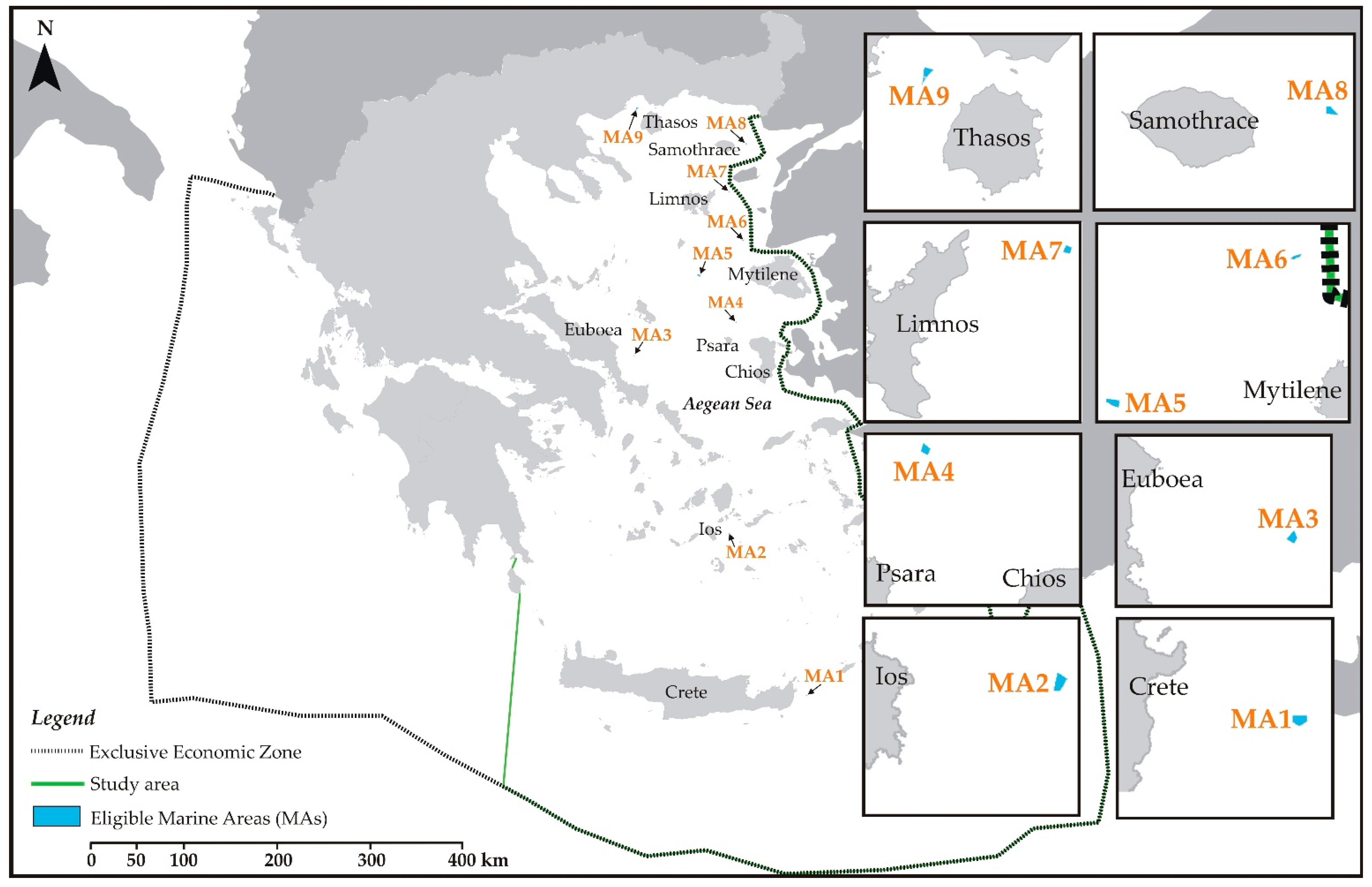
3.1. Determination of Eilgible Marine Areas for OSF Deployment

Using the exclusion criteria and the restriction zones of Table 1, several thematic maps have been created in GIS. Figure 2 shows indicatively the thematic maps of the exclusion criteria related to Protected Areas (PA), Aquaculture Zones (AZ), and Distance from Shore (DS).
By superimposing the thematic maps of all exclusion criteria, marine areas unsuitable for OSF siting are determined and, accordingly, marine sites eligible for the deployment of OSFs in the study area are identified (Phase I). Specifically, the corresponding results have indicated nine (9) eligible Marine Areas (MAs) in the Aegean Sea, Greece, which are shown in Figure 3 and are considered for further assessment and evaluation (Phase II). Six MAs (MA4–MA9) are located in the North Aegean, one (MA2) in the central Aegean, while the remaining two are located East of Crete (MA1) and offshore (East) of Euboea (MA3). The size of these areas is cited in Table 3.

3.2. Assessment and Ranking of Eligible Marine Areas

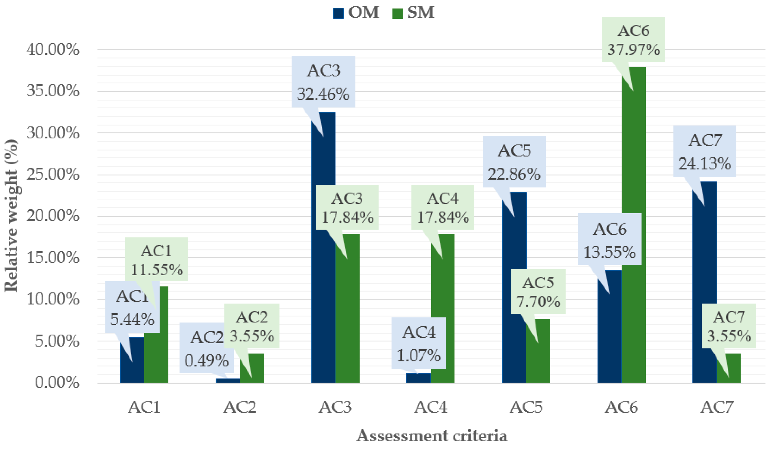
3.2.1. Weights of Assessment Criteria

The weights of the assessment criteria defined in Section 2.2 are calculated through EWM (Objective Model—OM) and AHP (Subjective Model—SM). EWM is the weighting method used herein to measure value dispersion in the examined decision-making problem, while the AHP method uses the pairwise comparison of the assessment criteria to quantify their relative weights. There is no predefined procedure or rules to perform pairwise comparisons and assign weights to the assessment criteria. Thus, AHP is a subjective process that, in most cases, depends on either the researchers’ decision or the expertise of relevant stakeholders and policymakers. In the current study, pairwise comparisons are performed based on the authors’ expertise [11,30,62] and their understanding of the study area’s local conditions and constraints.
Table 3 provides the initial assessment matrix used in OM, including the numerical values x i j of each eligible MA i , i = 1 , , 9 , for each AC j , j = 1 , , 7 , while Table 4 presents the pairwise comparison matrix of the seven assessment criteria used in SM. From Table 3, it is obvious that AC3, AC7, and AC5 show the highest degree of discrimination and grade discrimination, while the opposite holds true for AC4 and AC2. Accordingly, the entropy values of AC3, AC7, and AC5 (calculated equal to 0.881, 0.911, and 0.916, respectively) are smaller compared to those of AC4 and AC2 (equal to 0.996 and 0.998, respectively). Regarding Table 4, it is noted that the consistency ratio of the pairwise comparison matrix is C R   = 0.02, meaning that the results are consistent and acceptable.
The relative weights of the assessment criteria are quantified through EWM and AHP in OM and SM, respectively, and the corresponding results are presented in Figure 4. Starting with OM, it can be seen that AC3, AC7, and AC5 have the largest importance weights (32.46, 24.13, and 22.86%, respectively). This, in turn, indicates that the main voltage at a maximum distance of 100 km from the site area, the installation site area, and the serving population are, respectively, the three most important assessment criteria for determining the preference order of the OSF siting in the Aegean Sea, Greece, when OM is deployed. On the other hand, the distance from ports (AC4) and from the shore (AC2) have the smallest weights (1.07 and 0.49%, respectively) and, therefore, contribute slightly to the relevant decision-making process. All the above are in absolute accordance with the discussion made above regarding the entropy values and the degree/grade of discrimination of AC j , j = 2 , , 5 , and 7 .
In the case of SM, the relative weight of AC6 has the greatest value (37.97%) indicating that the solar radiation is the most important criterion for ranking MAs in the Aegean Sea, Greece. This result is in line with several studies on onshore solar farm siting that have highlighted that the total solar radiation is the assessment criterion with the greatest weighting factor [16,18,41]. The main voltage at a maximum distance of 100 km from the site area (AC3) and the distance from ports (AC4) are the next two most important criteria, having the same relative weight (17.84%). It should be noted that the total weight of the above three assessment criteria equals 73.65%. Consequently, the decision upon the sustainability of MAs for OSF deployment in the case of SM strongly depends on the availability of solar energy sources as well as on technical/economic factors. The priority weights of the remaining four assessment criteria in decreasing order are as follows: AC1 (11.55%), AC5 (7.70%), AC7 (3.55%), AC2 (3.55%).

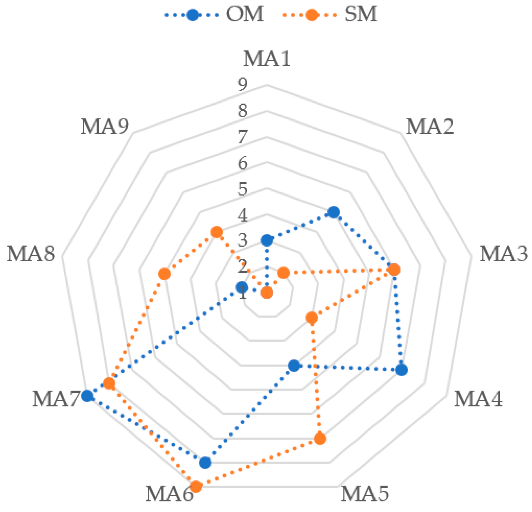
3.2.2. Ranking of Eligible Marine Areas

For both models (OM and SM), eligible MAs for OSF deployment are prioritized using TOPSIS. The distance of every feasible solution (MA1–MA9) from the ideal solution (Equation (11)) and the negative ideal solution (Equation (12)) is obtained, and each MA is ranked by the relative degree of approximation (Equation (13)). The corresponding results are presented in Table 5 and Table 6 for OM and SM, respectively, while comparison of the ranks between the two different methods is graphically presented in the radar chart of Figure 5.
The ranking results are different between the two models. In the case of OM (Table 5), the first three most preferable sites for the OSF deployment in the Aegean Sea, Greece, are MA9, MA8, and MA1 located, respectively, near Thasos, Samothrace (North Aegean), and Crete (Figure 3). Regarding the first two top choices, the existence of the highest (400 kV) capacity grid within a maximum distance of 100 km (AC3) from MA9–MA8, as well as the benefit of these two sites to serve a large population (AC5) and provide large installation area (AC7) contribute mainly to this ranking. MA1 corresponds to the third top choice due to the potential of this site to serve a large population (AC5). As for SM (Table 6), the first three top choices correspond to MA1, MA2, and MA4 offshore of Crete, Ios (Central Aegean), and Psara (North Aegean, near Chios), respectively (Figure 3). The large solar radiation values (AC6) in those three MAs contribute mainly to this ranking. For both models, the two least preferable sites correspond to MA6 and MA7 near Mytilene and Limnos, respectively (Figure 3). This is mainly attributed to the small values of AC3 (main voltage at a maximum distance of 100 km from the site area) and AC6 (solar radiation) for both these MAs.
The correlations in rankings between OM and SM are further examined, using Kendall rank correlation coefficient (Kendall’s τ coefficient) and the correlation value ( 0.39 ) reveals a low agreement between rankings.

4. Conclusions

Given the world’s growing interest in sustainable energy development and the vast and clean source of energy available for long-term exploitation, the current paper develops and presents a methodological framework for identifying the most appropriate marine areas in the Aegean Sea, Greece, for OSF siting.
Through the application of certain exclusion criteria and the use of GIS, nine (9) eligible MAs for the siting of OSFs in the study area are identified. Two different multi-criteria models (OM and SM), based on different weighting methods (EWM and AHP, respectively), are deployed to evaluate seven selected assessment criteria. The nine MAs are evaluated using TOPSIS according to the value of the relative degree of approximation. The main conclusions of the current research are summarized as follows:
  • Seven (7) assessment criteria are selected based on selected renewable energy resources literature (e.g., onshore solar and offshore wind and wave).
  • OM and SM give different relative weights to the assessment criteria and consequently different ranking of eligible MAs.
  • The solar radiation assessment criterion obtained the largest relative weight (37.97%) in the case of SM. This result is in line with several studies that consider solar radiation as the assessment criterion with the greatest weighting factor [16,18,41].
  • The offshore area (MA9) located near Thasos in North Aegean (size equal to 3.628 km2) presents the most suitable site for OSF deployment based on OM. This is attributed to the proximity of MA9 with the grid of the highest capacity as well as to the potential of the specific site to serve a large population and provide an extended installation area.
  • The offshore area (MA1) located near Crete (size equal to 0.973 km2) presents the most suitable site for OSF deployment based on SM. This is mainly attributed to the large value of solar radiation in this area.
  • AHP is one of the most suitable, easily applicable, and flexible MCDM methods for solving energy sector problems [63,64]. This method is recommended when experts in the field can perform the pairwise comparisons. Therefore, in this study, the results obtained by SM could be considered precise and reliable.
  • Entropy method is used when a decision maker is non-existent and relatively subjective weights cannot be obtained. Although the results of EWM are considered reliable and effective according to the traditional literature, the engineering practice supports that the EWM’s weighted result does not always accurately reflect the index’s information amount and importance [53]. This conclusion is also confirmed by the results of our study.
  • As the offshore solar industry develops, the technical characteristics and spatial requirements might change, which, in turn, might make other sites more feasible. However, the methodological framework proposed in this study provides a starting point for investigating where OSFs could be installed.
Offshore solar energy could be a viable option for making many coastal communities, islands, and isolated locations more sustainable. This investigation provides a logical scientific methodological approach that could be used to rank the site suitability of OSF technology and can be used efficiently in various renewable energy projects. In addition, this paper contributes to the fulfillment of one of the main goals of the European Green Deal related to the decarbonization of the EU’s energy system for reaching climate objectives. One of the key principles includes the deployment of a power sector based largely on renewable energy resources [65] and the presented methodology contributes to this direction.
The present investigation could be extended in order to include additional physical parameters as assessment siting criteria, as for example: (i) wind and wave conditions, which are critical for ensuring the structural reliability of OSF systems [66], and (ii) the water temperature, which contributes to increased efficiency (up to 10%) due to the water-cooling effect [67]. On the other hand, the assessment of the electricity production of OSF systems for different solar technologies might provide useful insights in future considerations. Finally, the subject of co-locating different marine renewable energy systems and, more specifically, the combination of offshore solar technologies with offshore wind turbines could be investigated as future work, as it can yield to sustainable solutions and contribute to launching the commercial feasibility of OSFs.

Author Contributions

Conceptualization, D.G.V., G.T., E.L. and N.K.; methodology, D.G.V., G.T., E.L. and N.K.; software, G.T. and N.K. formal analysis, D.G.V., G.T. and E.L.; investigation, G.T.; data curation, D.G.V., G.T. and N.K.; writing—original draft preparation, D.G.V. and E.L.; writing—review and editing, D.G.V., G.T., E.L. and N.K.; visualization, D.G.V., G.T., E.L. and N.K.; supervision, D.G.V. and E.L. All authors have read and agreed to the published version of the manuscript.

Funding

This research received no external funding.

Institutional Review Board Statement

Not applicable.

Informed Consent Statement

Not applicable.

Data Availability Statement

Not applicable.

Conflicts of Interest

The authors declare no conflict of interest.

Abbreviations

AC, Assessment criteria; AEEH, Areas to be licensed for Exploration and Exploitation of Hydrocarbons; AHP, Analytical Hierarchy Process; AOREP, Areas where Offshore Renewable Energy Projects; AZ, Aquaculture Zones; CI, Consistency Index; CR, Consistency Ratio; DS, Distance from Shore; ELECTRE, ELimination Et Choice Translating Reality; EWM, Entropy-based Weight Method; GIS, Geographic Information Systems; MA(s), Marine Area(s); MCDM, Multi-Criteria Decision Making; MEA, Military Exercise Areas; OM, Objective Model; OSF(s), Offshore Solar Farm(s); SM, Subjective Model; PA, Protected Areas; PROMETHEE, Preference Ranking Organization METHod for Enrichment of Evaluations; PSR, Ports and Shipping Routes; SAL, Site Area Limitations; SFSPSD/RES, Specific Framework for Spatial Planning and Sustainable Development for Renewable Energy Source; SM, Subjective Model; TOPSIS, Technique for Order Preference by Similarity to Ideal Solution; VIKOR, VIseKriterijumska Optimizacija I Kompromisno Resenje; WD, Water Depth.

References

  1. López, M.; Rodríguez, N.; Iglesias, G. Combined Floating Offshore Wind and Solar PV. J. Mar. Sci. Eng. 2020, 8, 576. [Google Scholar] [CrossRef]
  2. Taveira-Pinto, F.F.; Iglesias, G.; Rosa-Santos, P.; Deng, Z.D. Preface to Special Topic: Marine Renewable Energy. J. Renew. Sustain. Energy 2015, 7, 061601. [Google Scholar] [CrossRef] [Green Version]
  3. Kumar, V.; Shrivastava, R.L.; Untawale, S.P. Solar Energy: Review of Potential Green & Clean Energy for Coastal and Offshore Applications. Aquat. Procedia 2015, 4, 473–480. [Google Scholar] [CrossRef]
  4. Santafé, M.R.; Ferrer Gisbert, P.S.; Sánchez Romero, F.J.; Torregrosa Soler, J.B.; Ferrán Gozálvez, J.J.; Ferrer Gisbert, C.M. Implementation of a photovoltaic floating cover for irrigation reservoirs. J. Clean Prod. 2014, 66, 568–570. [Google Scholar] [CrossRef] [Green Version]
  5. Diendorfer, C.; Haider, M.; Lauermann, M. Performance Analysis of Offshore Solar Power Plants. Energy Procedia 2014, 49, 2462–2471. [Google Scholar] [CrossRef] [Green Version]
  6. Cagle, A.E.; Armstrong, A.; Exley, G.; Grodsky, S.M.; Macknick, J.; Sherwin, J.; Hernandez, R.R. The Land Sparing, Water Surface Use Efficiency, and Water Surface Transformation of Floating Photovoltaic Solar Energy Installations. Sustainability 2020, 12, 8154. [Google Scholar] [CrossRef]
  7. de Lima, R.L.P.; Paxinou, K.C.; Boogaard, F.; Akkerman, O.; Lin, F.Y. In-Situ Water Quality Observations under a Large-Scale Floating Solar Farm Using Sensors and Underwater Drones. Sustainability 2021, 13, 6421. [Google Scholar] [CrossRef]
  8. Kim, C.K.; Jang, S.; Kim, T.Y. Site selection for offshore wind farms in the southwest coast of South Korea. Renew. Energy 2018, 120, 151–162. [Google Scholar] [CrossRef]
  9. Mahdy, M.; Bahaj, A.S. Multi criteria decision analysis for offshore wind energy potential in Egypt. Renew. Energy 2018, 118, 278–289. [Google Scholar] [CrossRef]
  10. Schallenberg-Rodríguez, J.; Montesdeoca, N.G. Spatial planning to estimate the offshore wind energy potential in coastal regions and islands. Practical case: The Canary Islands. Energy 2018, 143, 91–103. [Google Scholar] [CrossRef]
  11. Vagiona, D.G.; Kamilakis, M. Sustainable site selection for offshore wind farms in the South Aegean—Greece. Sustainability 2019, 10, 749. [Google Scholar] [CrossRef] [Green Version]
  12. Wu, B.; Yip, T.L.; Xie, L.; Wang, Y. A fuzzy-MADM based approach for site selection of offshore wind farm in busy waterways in China. Ocean. Eng. 2018, 168, 121–132. [Google Scholar] [CrossRef]
  13. Argin, M.; Yerci, V.; Erdogan, N.; Kucuksari, S.; Cali, U. Exploring the offshore wind energy potential of Turkey based on multicriteria site selection. Energy Strategy Rev. 2019, 23, 33–46. [Google Scholar] [CrossRef]
  14. Deveci, M.; Özcan, E.; John, R.; Covrig, C.F.; Pamucar, D. A study on offshore wind farm siting criteria using a novel interval-valued fuzzy-rough based Delphi method. J. Environ. Manag. 2020, 270, 110916. [Google Scholar] [CrossRef]
  15. Fang, H.; Li, J.; Song, W. Sustainable site selection for photovoltaic power plant: An integrated approach based on prospect theory. Energy Convers. Manag. 2018, 174, 755–768. [Google Scholar] [CrossRef]
  16. Doorga, J.R.; Rughooputh, S.D.; Boojhawon, R. Multi-criteria GIS-based modelling technique for identifying potential solar farm sites: A case study in Mauritius. Renew. Energy 2019, 133, 1201–1219. [Google Scholar] [CrossRef]
  17. Rigo, P.D.; Rediske, G.; Rosa, C.B.; Gastaldo, N.G.; Michels, L.; Neuenfeldt Júnior, A.L.; Siluk, J.C.M. Renewable energy problems: Exploring the methods to support the decision-making process. Sustainability 2020, 12, 10195. [Google Scholar] [CrossRef]
  18. Al Garni, H.Z.; Awasthi, A. Solar PV power plant site selection using a GIS-AHP based approach with application in Saudi Arabia. Appl. Energy 2017, 206, 1225–1240. [Google Scholar] [CrossRef]
  19. Wang, C.N.; Nguyen, V.T.; Thai, H.T.N.; Duong, D.H. Multi-Criteria Decision Making (MCDM) approaches for solar power plant location selection in Viet Nam. Energies 2018, 11, 1504. [Google Scholar] [CrossRef] [Green Version]
  20. Ilbahar, E.; Cebi, S.; Kahraman, C. A state-of-the-art review on multi-attribute renewable energy decision making. Energy Strategy Rev. 2019, 25, 18–33. [Google Scholar] [CrossRef]
  21. Keeley, A.R.; Matsumoto, K. Relative significance of determinants of foreign direct investment in wind and solar energy in developing countries—AHP analysis. Energy Policy 2018, 123, 337–348. [Google Scholar] [CrossRef]
  22. Ozdemir, S.; Sahin, G. Multi-criteria decision-making in the location selection for a solar PV power plant using AHP. Measurement 2018, 129, 218–226. [Google Scholar] [CrossRef]
  23. Colak, H.E.; Memisoglu, T.; Gercek, Y. Optimal site selection for solar photovoltaic (PV) power plants using GIS and AHP: A case study of Malatya Province, Turkey. Renew. Energy 2020, 149, 565–576. [Google Scholar] [CrossRef]
  24. Ruiz, H.; Sunarso, A.; Ibrahim-Bathis, K.; Murti, S.; Budiarto, I. GIS-AHP Multi Criteria Decision Analysis for the optimal location of solar energy plants at Indonesia. Energy Rep. 2020, 6, 3249–3263. [Google Scholar] [CrossRef]
  25. Prieto-Amparán, J.A.; Pinedo-Alvarez, A.; Morales-Nieto, C.R.; Valles-Aragón, M.C.; Álvarez-Holguín, A.; Villarreal-Guerrero, F. A regional GIS-assisted multi-criteria evaluation of site-suitability for the development of solar farms. Land 2021, 10, 217. [Google Scholar] [CrossRef]
  26. Günen, M.A. A comprehensive framework based on GIS-AHP for the installation of solar PV farms in Kahramanmaraş, Turkey. Renew. Energy 2021, 178, 212–225. [Google Scholar] [CrossRef]
  27. Alhuyi Nazari, M.; Aslani, A.; Ghasempour, R. Analysis of solar farm site selection based on TOPSIS approach. Int. J. Soc. Ecol Sustain. Dev. 2019, 9, 12–25. [Google Scholar] [CrossRef]
  28. Ali Sadat, S.; Vakilalroaya Fini, M.; Hashemi-Dezaki, H.; Nazififard, M. Barrier analysis of solar PV energy development in the context of Iran using fuzzy AHP-TOPSIS method. Sustain. Energy Technol. Assess. 2021, 47, 101549. [Google Scholar] [CrossRef]
  29. Ministry of Environment, Energy and Climate Change (MEECC). Specific Framework for Spatial Planning and Sustainable Development for Renewable Energy Sources (SFSPSD/RES). JMD 49828/2008 OGHE B′ 2464/3-12-08. 2008. Available online: https://ypen.gov.gr/wp-content/uploads/2020/11/FEK2464B_2008_RES.pdf (accessed on 13 January 2022).
  30. Vasileiou, M.; Loukogeorgaki, E.; Vagiona, D.G. GIS-based multi-criteria decision analysis for site selection of hybrid offshore wind and wave energy systems in Greece. Renew. Sustain. Energy Rev. 2017, 73, 745–757. [Google Scholar] [CrossRef]
  31. Schillings, S.; Wanderer, T.; Cameron, L.; Tjalling van der Wal, J.; Jacquemin, J.; Veumb, K. A decision support system for assessing offshore wind energy potential in the North Sea. Energy Policy 2012, 49, 541–551. [Google Scholar] [CrossRef] [Green Version]
  32. Kim, T.; Park, J.I.; Maeng, J. Offshore wind farm site selection study around Jeju Island, South Korea. Renew. Energy 2016, 94, 619–628. [Google Scholar] [CrossRef]
  33. Murphy, J.; Lynch, K.; Serri, L.; Airdoldi, D.; Lopes, M. Site selection analysis for offshore combined resource projects in Europe. In Report of the Off-Shore Renewable Energy Conversion Platforms—Coordination Action (ORECCA) Project; 2011; Available online: http://orecca.rse-web.it/doc_info/Site_Selection_Analysis_Report.pdf (accessed on 13 January 2022).
  34. Mekonnen, A.; Gorsevski, P. A web-based participatory GIS (PGIS) for offshore wind farm suitability within Lake Erie, Ohio. Renew. Sustain. Energy Rev. 2015, 41, 162–177. [Google Scholar] [CrossRef] [Green Version]
  35. Jay, S. Planners to the rescue: Spatial planning facilitating the development of offshore wind energy. Mar. Pollut. Bull. 2010, 10, 493–499. [Google Scholar] [CrossRef] [PubMed]
  36. Ikhennicheu, M.; Danglade, B.; Pascal, R.; Arramounet, V.; Trébaol, Q.; Gorintin, F. Analytical method for loads determination on floating solar farms in three typical environments. Sol. Energy 2021, 219, 34–41. [Google Scholar] [CrossRef]
  37. Cradden, L.; Kalogeri, C.; Martinez Barrios, I.; Galanis, G.; Ingram, D.; Kallos, G. Multi-criteria site selection for offshore renewable energy platforms. Renew. Energy 2016, 87, 791–806. [Google Scholar] [CrossRef] [Green Version]
  38. Díaz, H.; Fonseca, R.B.; Guedes Soares, C. Site selection process for floating offshore wind farms in Madeira Islands. In Advances in Renewable Energies Offshore; Guedes, S.C., Ed.; Taylor & Francis Group: London, UK, 2019; pp. 729–737. [Google Scholar]
  39. Spyridonidou, S.; Sismani, G.; Loukogeorgaki, E.; Vagiona, D.G.; Ulanovsky, H.; Madar, D. Sustainable spatial energy planning of large-scale wind and PV farms in Israel: A collaborative and participatory planning approach. Energies 2021, 14, 551. [Google Scholar] [CrossRef]
  40. Oliveira-Pinto, S.; Stokkermans, J. Marine floating solar plants: An overview of potential, challenges and feasibility. Proc. Inst. Civ. Eng. Marit. Eng. 2020, 173, 120–135. [Google Scholar] [CrossRef]
  41. Doljak, D.; Stanojević, G. Evaluation of natural conditions for site selection of ground-mounted photovoltaic power plants in Serbia. Energy 2017, 127, 291–300. [Google Scholar] [CrossRef] [Green Version]
  42. Vagiona, D.G. Comparative Multicriteria Analysis methods for ranking sites for solar farm deployment: A Case study in Greece. Energies 2021, 14, 8371. [Google Scholar] [CrossRef]
  43. Government Gazette 2885/2017. Available online: https://www.greekhydrocarbons.gr/pdfs/BlockDocuments/2885B_2017_Lease_Agreement-Geographical_Delimitation.pdf (accessed on 1 October 2021).
  44. Hellenic Navy Hydrographic Service. Available online: https://www.hnhs.gr/el/ (accessed on 1 October 2021).
  45. Open Geospatial Data and Services for Greece. Available online: http://geodata.gov.gr/ (accessed on 1 October 2021).
  46. MarineTraffic: Global Ship Tracking Intelligence. Available online: https://www.marinetraffic.com/en/ais/home/centerx:-12.0/centery:25.0/zoom:4 (accessed on 1 October 2021).
  47. WWF Greece. Available online: https://www.contentarchive.wwf.gr/images/pdfs/AquacultureLow.pdf (accessed on 1 October 2021).
  48. Regulatory Authority for Energy. Available online: https://geo.rae.gr/ (accessed on 1 October 2021).
  49. Independent Power Transmission Generation. Available online: https://www.admie.gr/en/grid/description/lines-map (accessed on 1 October 2021).
  50. Hellenic Statistical Authority. Available online: https://www.statistics.gr/el/statistics/pop (accessed on 1 October 2021).
  51. Nikitidou, E.; Kazantzidis, A.; Tzoumanikas, P.; Salamalikis, V.; Bais, A.F. Retrieval of surface solar irradiance, based on satellite-derived cloud in-formation, in Greece. Renew. Energy 2015, 90, 776–783. [Google Scholar] [CrossRef]
  52. Hsing-Chen, L.; Ching-Ter, C. Comparative analysis of MCDM methods for ranking renewable energy sources in Taiwan. Renew. Sustain. Energy Rev. 2018, 92, 883–896. [Google Scholar] [CrossRef]
  53. Zhu, Y.; Tian, D.; Yan, F. Effectiveness of entropy weight method in decision-making. Math. Probl. Eng. 2020, 2020, 3564835. [Google Scholar] [CrossRef]
  54. Dong, G.H.; Shen, J.Q.; Jia, Y.Z.; Sun, F.H. Comprehensive evaluation of water resource security: Case study from Luoyang City, China. Water 2018, 10, 1106. [Google Scholar] [CrossRef]
  55. Amiri, V.; Rezaei, M.; Sohrabi, N. Groundwater quality assessment using entropy weighted water quality index (EWQI) in Lenjanat, Iran. Environ. Earth Sci. 2014, 72, 3479–3490. [Google Scholar] [CrossRef]
  56. Saaty, R.W. The analytic hierarchy process—What it is and how it is used. Math. Model. 1987, 9, 161–176. [Google Scholar] [CrossRef] [Green Version]
  57. Saaty, T.L. How to make a decision: The analytic hierarchy process. Eur. J. Oper. Res. 1990, 48, 9–26. [Google Scholar] [CrossRef]
  58. Chen, S.J.; Hwang, C.L. Fuzzy Multiple Attribute Decision Making: Methods and Applications; Springer: Berlin/Heidelberg, Germany, 1992. [Google Scholar]
  59. Hwang, C.L.; Yoon, K. Multiple Attribute Decision Making: Methods and Applications, A State-of-the-Art Survey; Springer: Berlin/Heidelberg, Germany, 1981. [Google Scholar]
  60. Jahanshahloo, G.R.; Hosseinzadeh Lotfi, F.; Izadikhah, M. Extension of the TOPSIS method for decision-making problems with fuzzy data. Appl. Math. Comput. 2006, 181, 1544–1551. [Google Scholar] [CrossRef]
  61. Opricovic, S.; Tzeng, G.H. Compromise solution by MCDM methods: A comparative analysis of VIKOR and TOPSIS. Eur. J. Oper. Res. 2004, 156, 445–455. [Google Scholar] [CrossRef]
  62. Vagiona, D.G.; Karanikolas, N.M. A multicriteria approach to evaluate offshore wind farms siting in Greece. Glob. NEST J. 2012, 14, 235–243. [Google Scholar] [CrossRef]
  63. Kaya, I.; Çolak, M.; Terzi, F. Use of MCDM techniques for energy policy and decision-making problems: A review. Int. J. Energy Res. 2018, 42, 2344–2372. [Google Scholar] [CrossRef]
  64. Siksnelyte-Butkiene, I.; Zavadskas, E.K.; Streimikiene, D. Multi-Criteria Decision-Making (MCDM) for the assessment of renewable energy technologies in a household: A review. Energies 2020, 13, 1164. [Google Scholar] [CrossRef] [Green Version]
  65. European Commission Factsheet, Clean Energy. Available online: https://ec.europa.eu/commission/presscorner/detail/en/fs_19_6723 (accessed on 13 January 2022).
  66. López, M.; Claus, R.; Soto, F.; Cebada, A.; Hernández-Garrastacho, Z.A.; Simancas, O. Structural reliability of a novel offshore floating photo. In Developments in the Analysis and Design of Marine Structures, 1st ed.; CRC Press: London, UK, 2021. [Google Scholar]
  67. Charles Lawrence Kamuyu, W.; Lim, J.R.; Won, C.S.; Ahn, H.K. Prediction model of photovoltaic module temperature for power performance of floating PVs. Energies 2018, 11, 447. [Google Scholar] [CrossRef] [Green Version]
Figure 1. Methodological approach for site selection of OSFs in the Aegean Sea, Greece.
Jmse 10 00224 g001
Figure 2. Thematic maps of exclusion criteria related to: (a) Protected Areas (PA), (b) Aquaculture Zones (AZ), (c) Distance from Shore (DS).
Jmse 10 00224 g002
Figure 3. Eligible areas for OSF siting in the Aegean Sea, Greece.
Jmse 10 00224 g003
Figure 4. Relative weights of assessment criteria (AC1~AC7) in OM and SM.
Jmse 10 00224 g004
Figure 5. Radar chart for MAs ranking in terms of OM and SM.
Jmse 10 00224 g005
Table 1. Exclusion criteria and restriction zones.
Exclusion CriteriaUnsuitable Areas
Areas to be licensed for Exploration and Exploitation of Hydrocarbons (AEEH)Occupied areas [30]
Military Exercise Areas (MEA)Occupied areas (e.g., [31,32])
Ports and Shipping Routes (PSR)<1 km buffer from sea route [32], >100 km from deep water ports, and >50 km from small piers [33]
Protected Areas (PA)<1 km (e.g., [11,34])
Aquaculture Zones (AZ)Occupied areas (e.g., [31,35])
Distance from Shore (DS)<10 km [29]
Areas where Offshore Renewable Energy Projects (AOREP) have been already installed or planned to be installedOccupied areas [30]
Water Depth (WD)>100 m based on [36]
Site Area Limitations (SAL)<0.3 and >7 km2
Table 2. Saaty’s fundamental scale [57].
Intensity of Importance on an Absolute ScaleDefinitionReasoning
1Equal importanceTwo activities contribute equally to the goal
3Moderate importance of one over anotherOne activity is preferred over another based on experience and judgment
5Essential or strong importanceOne activity is clearly superior to another based on experience and judgment
7Very strong importanceAn activity is strongly preferred, and its dominance is evident in practice
9Extreme importanceThe evidence favoring one activity over another is of the highest possible order of affirmation
2, 4, 6, 8Intermediate valuesWhen a compromise is required
Table 3. Initial assessment matrix for OM.
AC1
(m)
AC2 (km)AC3 (kV)AC4
(km)
AC5
(Population)
AC6 (kWh/m2)AC7
(km2)
MA110011–25150≤50686,9691801–19000.973
MA210011–25150≤50119,8871801–19001.071
MA310011–25150≤50176,2641701–18001.112
MA410011–256651–70176,2641801–19001.322
MA510026–5066≤50176,2641701–18004.885
MA610026–506651–70176,2641601–17001.669
MA75011–256651–70176,2641601–17000.974
MA85011–25400≤50176,2641601–17001.615
MA95011–25400≤50176,2641601–17003.628
Table 4. Pairwise comparison matrix of assessment criteria for SM.
AC1AC2AC3AC4AC5AC6AC7
AC1141/21/221/44
AC21/411/51/51/31/71
AC3251131/35
AC4251131/35
AC51/231/31/311/53
AC64733517
AC71/411/51/51/31/71
Table 5. Distance of each MA from the ideal and the negative ideal solution and final ranking in OM.
S i + S i C i + Ranking
MA10.18650.16610.47123
MA20.24030.06110.20275
MA30.23090.05070.17996
MA40.25250.04760.15867
MA50.22130.13820.38444
MA60.25060.02860.10258
MA70.26200.01860.06639
MA80.18470.17280.48342
MA90.15210.19450.56111
Table 6. Distance of each MA from the ideal and the negative ideal solution and final ranking in SM.
S i + S i C i + Ranking
MA1 0.0779 0.1344 0.6330 1
MA2 0.0936 0.1239 0.5696 2
MA3 0.1093 0.0654 0.3745 6
MA4 0.1086 0.1228 0.5307 3
MA5 0.1242 0.0642 0.3410 7
MA6 0.1628 0.0174 0.0967 9
MA7 0.1617 0.0279 0.1472 8
MA8 0.1324 0.0964 0.4214 5
MA9 0.1315 0.0973 0.4253 4
Publisher’s Note: MDPI stays neutral with regard to jurisdictional claims in published maps and institutional affiliations.

