
3D Flooding Maps as Response to Tsunami Events: Applications in the Central Sicilian Channel (Southern Italy)

 ,
,  ,
,  , and
, and 
Abstract
1. Introduction
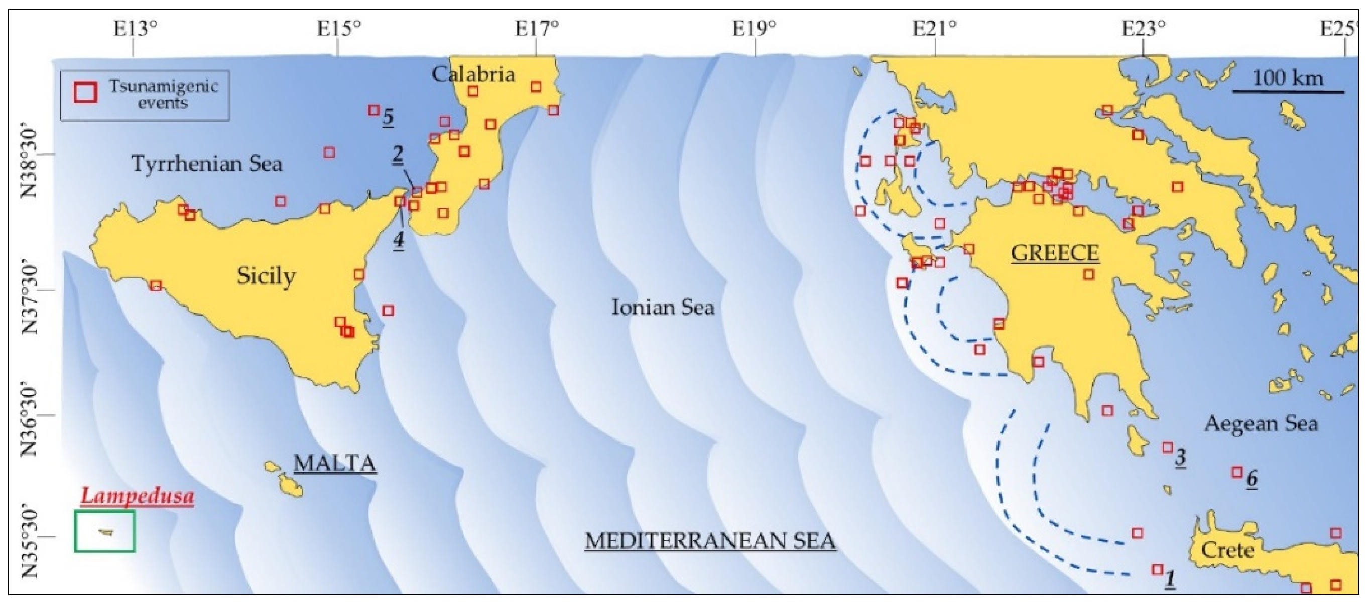
Historical Geophysical Framework in the Mediterranean Area
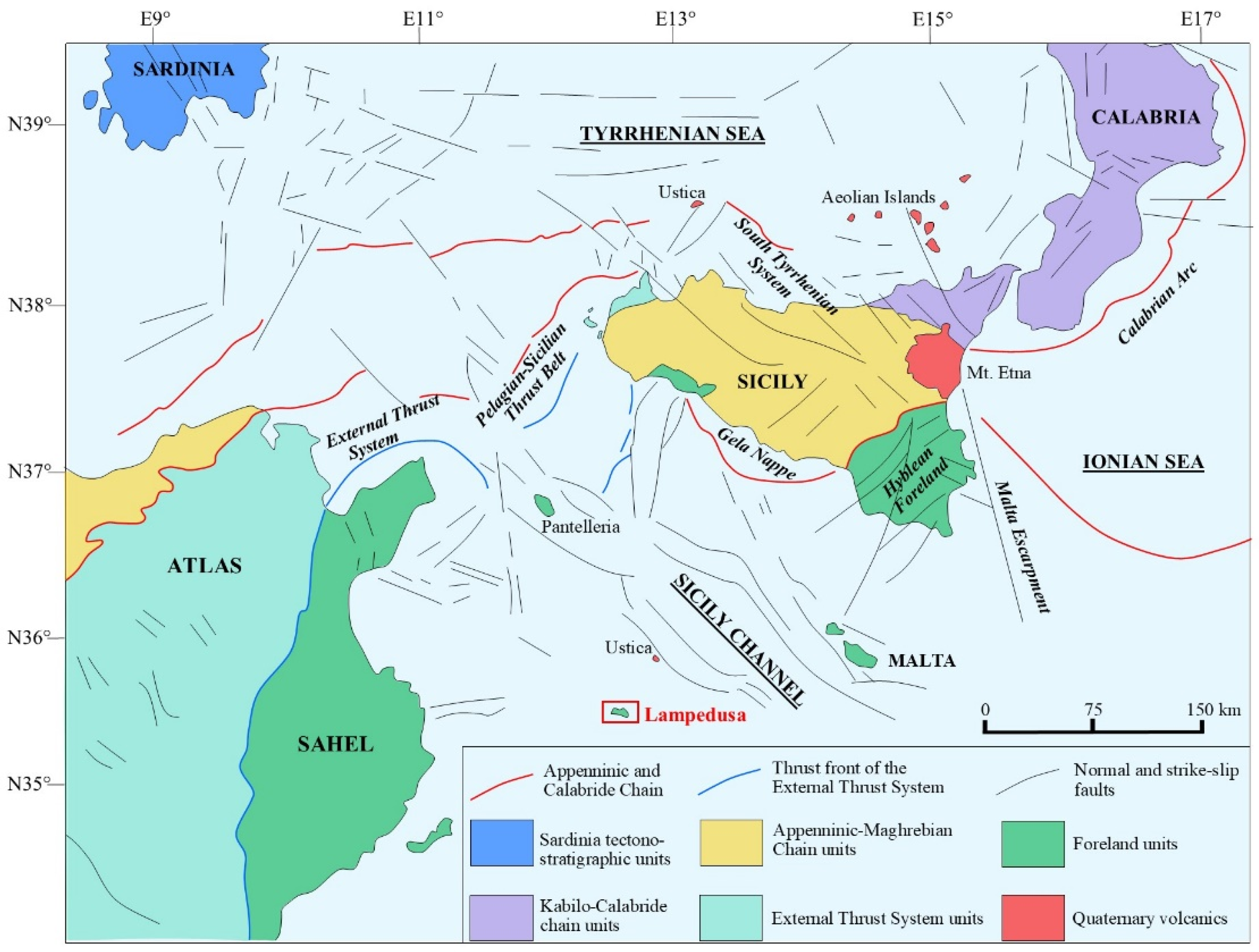
2. Geological Setting of the Sicily Channel, Italy
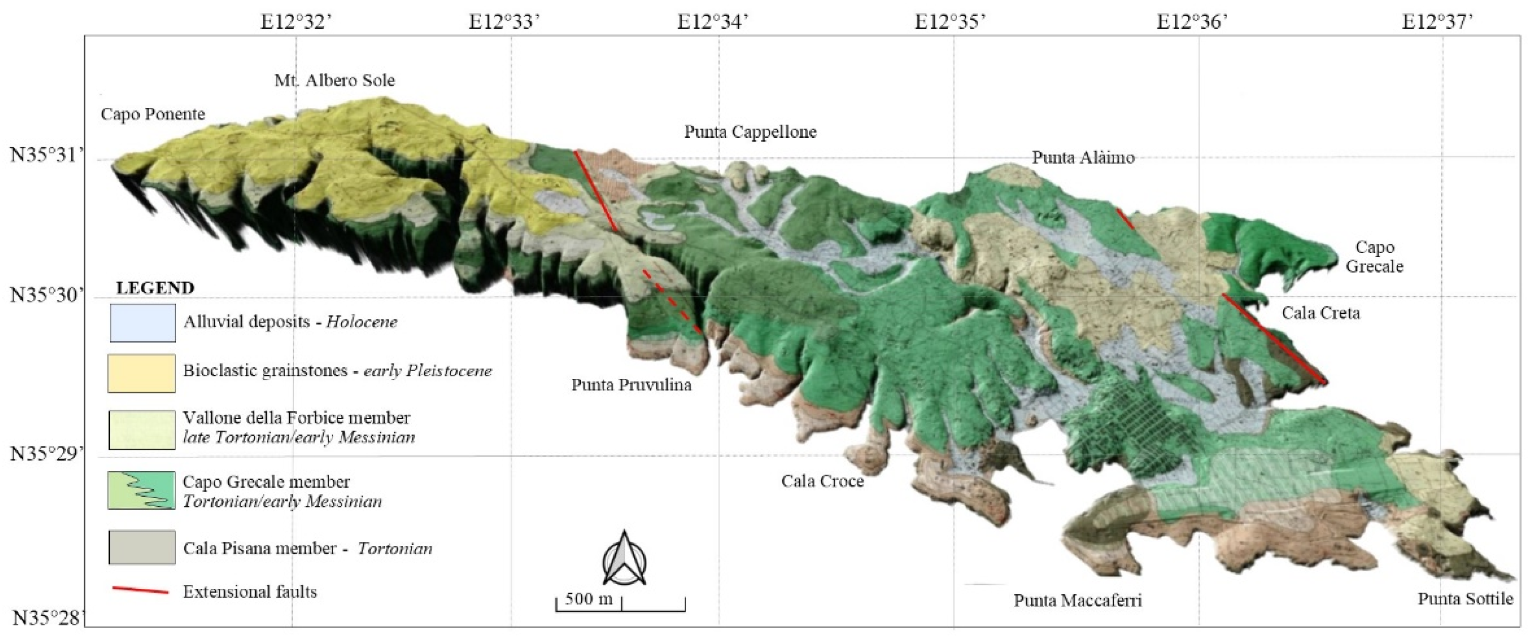
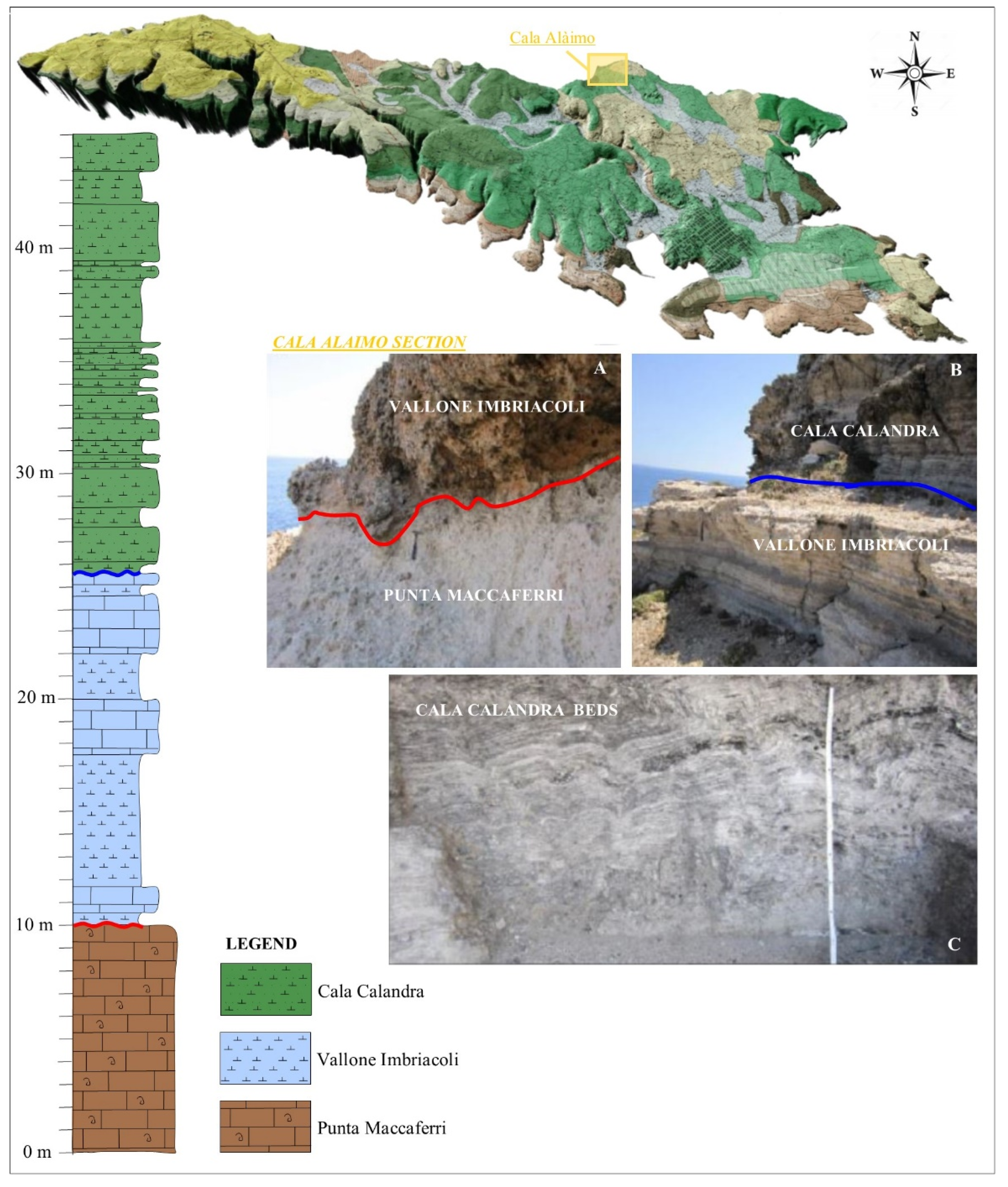
2.1. Stratigraphic Setting of Lampedusa Island
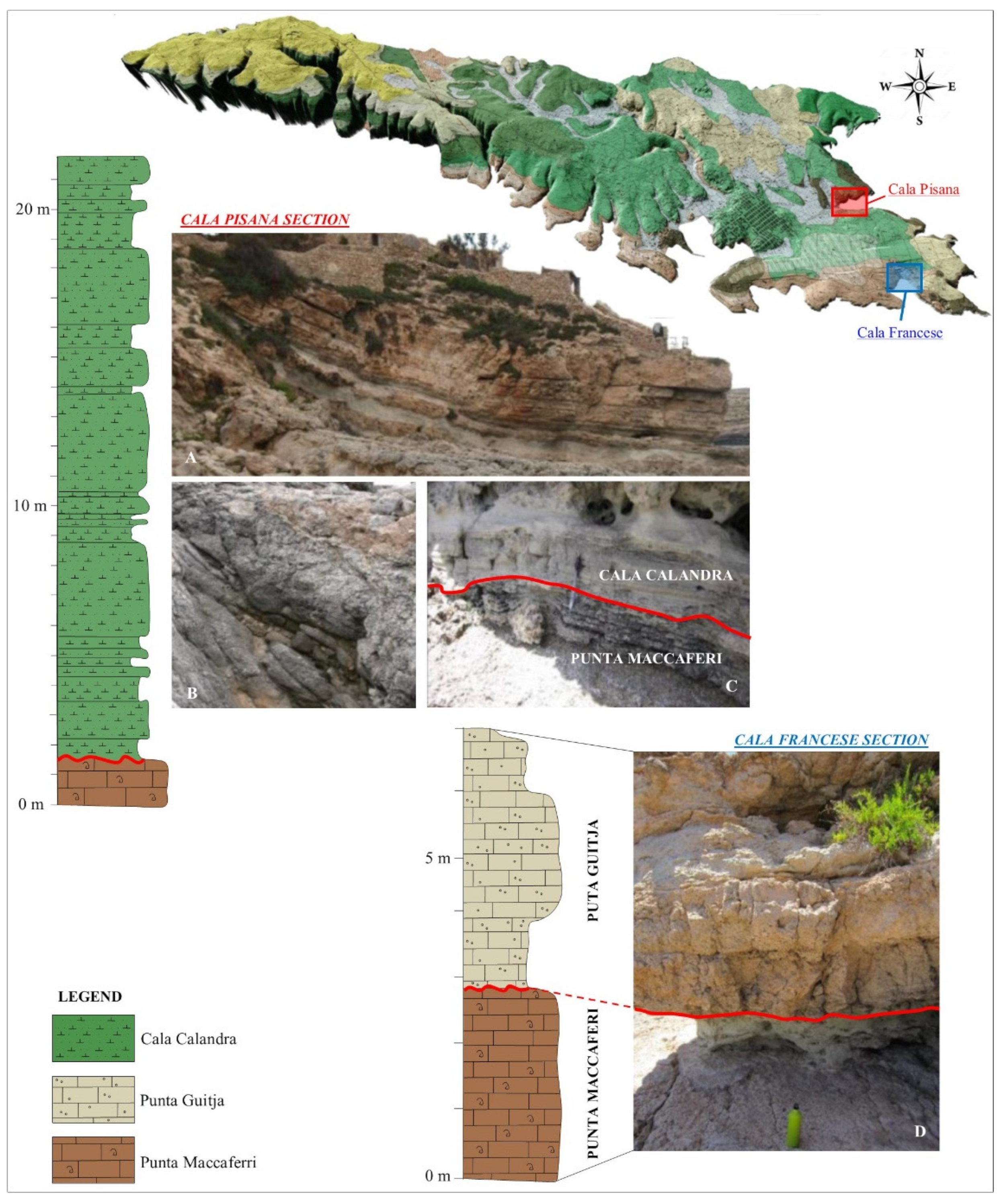
2.1.1. The Cala Pisana Member (Mb)
2.1.2. The Capo Grecale Mb
2.1.3. The Vallone Della Forbice Mb
2.1.4. Pleistocene and Holocene Deposits
3. Methodology
- Water level: 0 m;
- Water level increase amount: 5 m;
- Select what to increase water level from: Sea Level = 0;
- Vertical exaggeration: 5x;
- Resolution with which the terrain is sampled to calculate the flooded area: defaults.
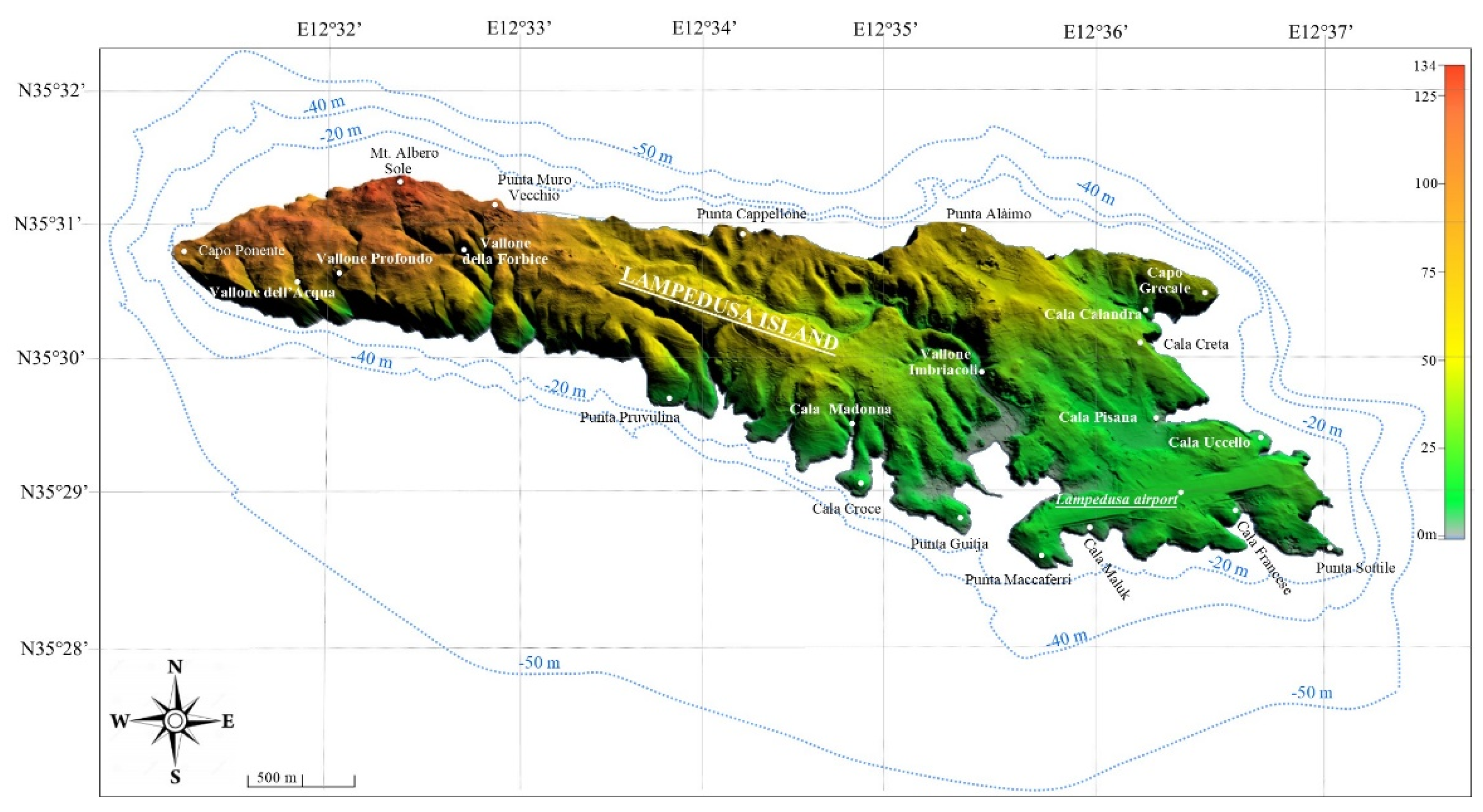
4. Geomorphological Setting of Lampedusa Island
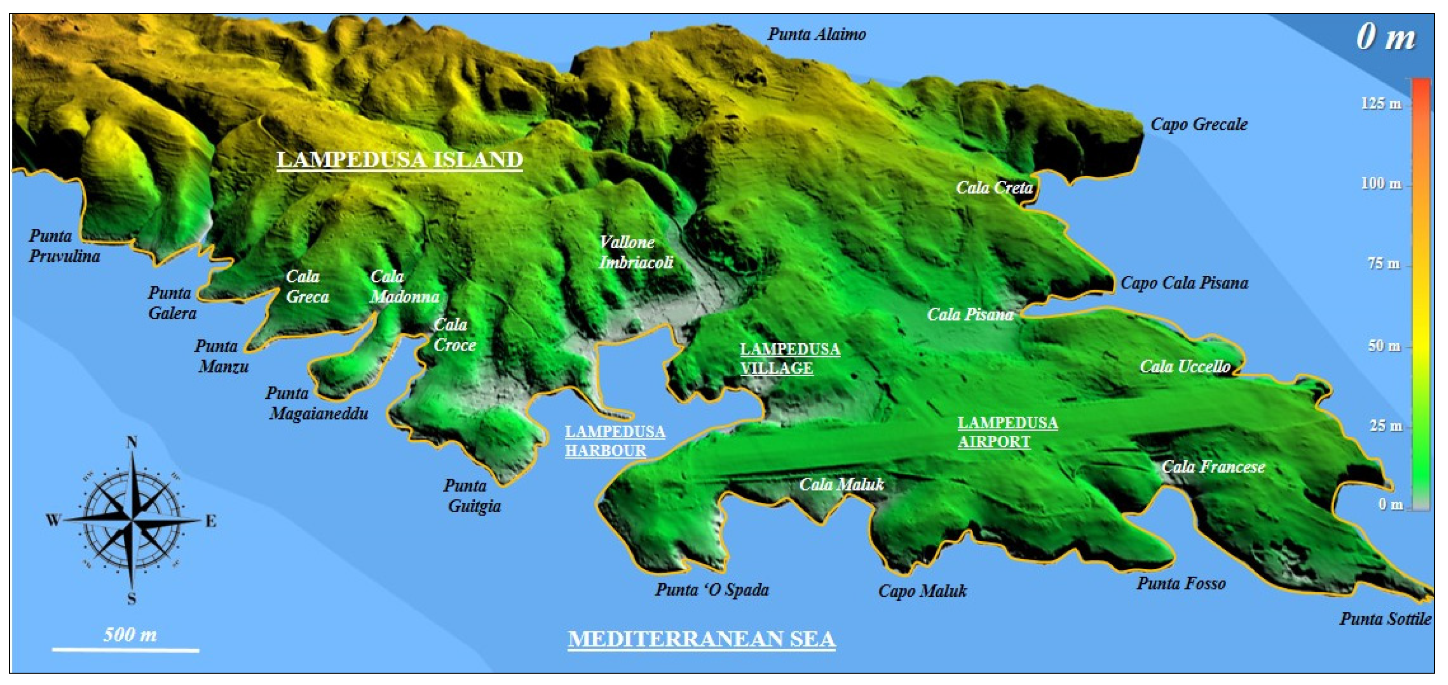
5. 3D Flooding Maps
- -
- The main tsunamigenic earthquakes known in the literature are mainly concentrated in the eastern sector of the Mediterranean Sea (Table 1);
- -
- Here, a high concentration of low beaches (on average 5 m high) is present and evolves in the northwest-southeast direction according to a rias coastline (Figure 3).
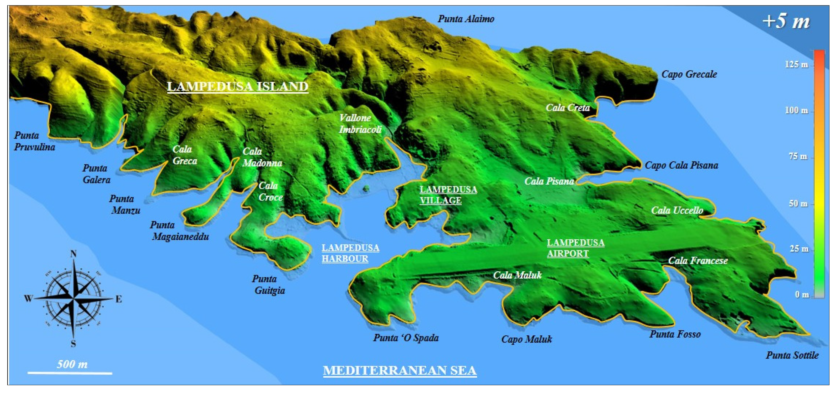
5.1. Sea Level Variation: +5 m
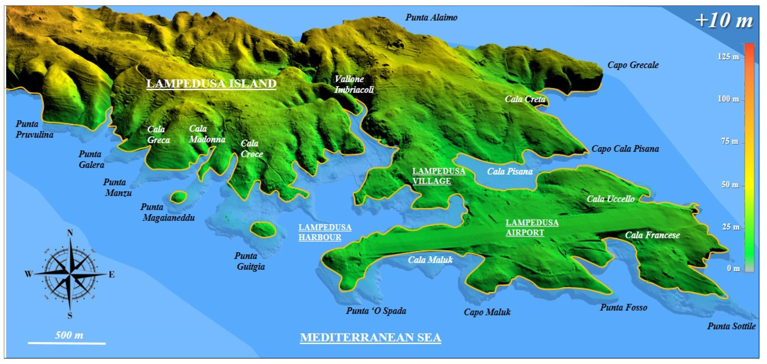
5.2. Sea Level Variation: +10 m
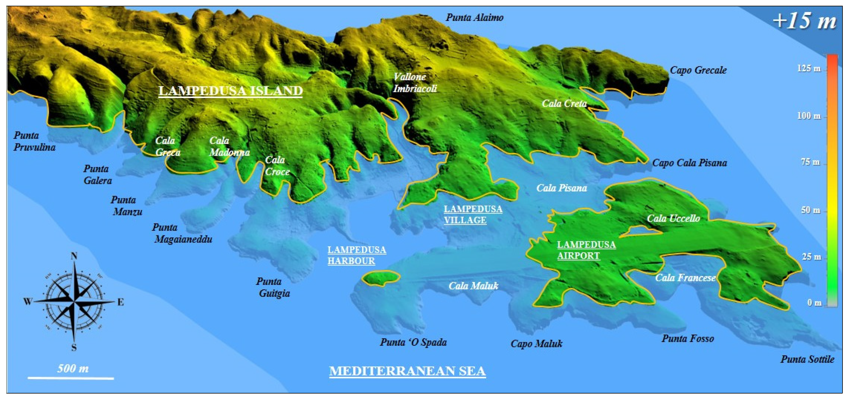
5.3. Sea Level Variation: +15 m
6. Conclusions
- 1.
- The general tabular setting of the Lampedusa island, slightly tilted towards the east, is lithologically associated with medium-low cohesion formations (carbonate mudstones of the Vallone Imbriacoli Unit and marly lithotypes of the Cala Calandra Unit) outcropping in the eastern portion of Lampedusa where the paleo-hydrographic network is well-developed and the coastline is widely low. Therefore, the south-eastern sector of the island appears to be the most suitable for testing the simulations of 3D flooding maps, which was the main goal of this work.
- 2.
- The updated stratigraphic analysis of Lampedusa was crucial for a detailed geomorphological reconstruction of the island. On the basis of a high-resolution DEM (2 m × 2 m cells), the 3D flooding maps were carried out assuming three different maximum runup steps (+5 m, +10 m, and + 15 m), comparable with historical tsunamigenic events in the central Mediterranean area.
- 3.
- The focal points of Lampedusa (harbor, airport, and main village)—concentrated in the southern sector of the island—already appear threatened with a runup of just +5 m. However, such areas would be seriously compromised with runups of +10 m and +15 m, where the area flooded by the sea grows up to almost 10 times.
Author Contributions
Funding
Institutional Review Board Statement
Informed Consent Statement
Data Availability Statement
Acknowledgments
Conflicts of Interest
References
- Intergovernmental Oceanographic Commission of UNESCO. Reducing and Managing the Risk of Tsunamis. In IOC Manuals and Guides, 57; IOC/2011/MG/57Rev.2; UNESCO: Paris, France, 2011; p. 74. [Google Scholar]
- D’Acremont, E.; Lafuerza, S.; Rabaute, A.; Lafosse, M.; Jollivet Castelot, M.; Gorini, C.; Alonso, B.; Ercilla, G.; Vazquez, J.T.; Vandorpe, T.; et al. Distribution and origin of submarine landslides in the active margin of the southern Alboran Sea (Western Mediterranean Sea). Mar. Geol. 2022, 445, 106739. [Google Scholar] [CrossRef]
- Zaniboni, F.; Pagnoni, G.; Paparo, M.A.; Gauchery, T.; Rovere, M.; Argnani, A.; Armigliato, A.; Tinti, S. Tsunamis from submarine collapses along the eastern slope of the Gela basin (Strait of Sicily). Front. Earth Sci. 2021, 8, 602171. [Google Scholar] [CrossRef]
- Valensise, G.; Pantosti, D.A. 125 Kyr-long geological record of seismic source repeatability: The Messina Straits (southern Italy) and the 1908 earthquake (Ms 7 1/2). Terra Nova 1992, 4, 472–483. [Google Scholar] [CrossRef]
- Okal, E.A.; Synolakis, C.E.; Uslu, B.; Kalligeris, N.; Voukouvalas, E. The 1956 earthquake and tsunami in Amorgos, Greece. Geophys. J. Int. 2009, 178, 1533–1554. [Google Scholar] [CrossRef]
- Alasset, P.J.; Hébert, H.; Maouche, S.; Calbini, V.; Meghraoui, M. The tsunami induced by the 2003 Zemmouri earthquake (MW = 6.9, Algeria): Modelling and results. Geophys. J. Int. 2006, 166, 213–226. [Google Scholar] [CrossRef]
- Cattaneo, A.; Babonneau, N.; Ratzov, G.; Yelles, K.; Brac, R. Searching for the seafloor signature of the 21 May 2003 Boumerdes earthquake offshore central Algeria. Nat. Hazards Earth Syst. Sci. 2012, 12, 2159–2172. [Google Scholar] [CrossRef]
- Samaras, A.G.; Karambas, T.V.; Archetti, R. Simulation of tsunami generation, propagation and coastal inundation in the Eastern Mediterranean. Ocean. Sci. 2015, 11, 643–655. [Google Scholar] [CrossRef]
- Scicchitano, G.; Costa, B.; Di Stefano, A.; Longhitano, S.G.; Monaco, C. Tsunami and storm deposits preserved within a ria-type rocky coastal setting (Siracusa, SE Sicily). Z. Geomorphol. Suppl. 2010, 54, 51. [Google Scholar] [CrossRef]
- Lo Re, C.; Manno, G.; Ciraolo, G. Tsunami propagation and flooding in Sicilian Coastal Areas by means of a weakly dispersive Boussinesq model. Water 2020, 12, 1448. [Google Scholar] [CrossRef]
- Paparo, M.A.; Armigliato, A.; Pagnoni, G.; Zaniboni, F.; Tinti, S. Earthquake-triggered landslides along the Hyblean-Malta Escarpment (off Augusta, eastern Sicily, Italy)–assessment of the related tsunamigenic potential. Adv. Geosci. 2017, 44, 1–8. [Google Scholar] [CrossRef]
- Milia, A.; Iannace, P.; Torrente, M.M. Active tectonic structures and submarine landslides offshore southern Apulia (Italy): A new scenario for the 1743 earthquake and subsequent tsunami. Geo-Mar. Lett. 2017, 37, 229–239. [Google Scholar] [CrossRef]
- Evelpidou, N.; Karkani, A.; Polidorou, M.; Saitis, G.; Zerefos, C.; Synolakis, C.; Gogou, M. Palaeo-Tsunami Events on the Coasts of Cyprus. Geosciences 2022, 12, 58. [Google Scholar] [CrossRef]
- Biolchi, S.; Furlani, S.; Antonioli, F.; Baldassini, N.; Causon Deguara, J.; Devoto, S.; Scicchitano, G. Boulder accumulations related to extreme wave events on the eastern coast of Malta. Nat. Hazards Earth Sys. 2016, 16, 737–756. [Google Scholar] [CrossRef]
- Evelpidou, N.; Zerefos, C.; Synolakis, C.; Repapis, C.; Karkani, A.; Polidorou, M.; Saitis, G. Coastal Boulders on the SE Coasts of Cyprus as Evidence of Palaeo-Tsunami Events. J. Mar. Sci. Eng. 2020, 8, 812. [Google Scholar] [CrossRef]
- Papathoma, M.; Dominey-Howes, D. Tsunami vulnerability assessment and its implications for coastal hazard analysis and disaster management planning, Gulf of Corinth, Greece. Nat. Hazards Earth Syst. Sci. 2003, 3, 733–747. [Google Scholar] [CrossRef]
- Ambraseys, N.; Synolakis, C. Tsunami catalogs for the Eastern Mediterranean, revisited. J. Earthq. Eng. 2010, 14, 309–330. [Google Scholar] [CrossRef]
- Dominey-Howes, D.; Papathoma, M. Validating a tsunami vulnerability assessment model (the PTVA model) using field data from the 2004 Indian Ocean tsunami. Nat. Hazards 2007, 40, 113–136. [Google Scholar] [CrossRef]
- Sørensen, M.B.; Spada, M.; Babeyko, A.; Wiemer, S.; Grünthal, G. Probabilistic tsunami hazard in the Mediterranean Sea. J. Geophys. Res. 2012, 117, 1–15. [Google Scholar] [CrossRef]
- Batzakis, D.V.; Misthos, L.M.; Voulgaris, G.; Tsanakas, K.; Andreou, M.; Tsodoulos, I.; Karymbalis, E. Assessment of Building Vulnerability to Tsunami Hazard in Kamari (Santorini Island, Greece). J. Mar. Sci. Eng. 2020, 8, 886. [Google Scholar] [CrossRef]
- Dominey-Howes, D. Assessment of tsunami magnitude and implications for urban hazard planning. Disaster Prev. Manag. 1998, 7, 176–182. [Google Scholar] [CrossRef]
- Grasso, M.; Pedley, H.M. The Pelagian Islands: A new geological interpretation from sedimentological and tectonic studies and its bearing on the evolution of the Central Mediterranean Sea (Pelagian Block). Geol. Romana 1985, 24, 13–34. [Google Scholar]
- Distefano, S.; Gamberi, F.; Baldassini, N.; Di Stefano, A. Late Miocene to Quaternary structural evolution of the Lampedusa Island offshore. Geogr. Fis. Din. Quat. 2018, 41, 17–31. [Google Scholar]
- Distefano, S.; Gamberi, F.; Baldassini, N.; Di Stefano, A. Neogene stratigraphic evolution of a tectonically controlled continental shelf: The example of the Lampedusa Island. Ital. J. Geosci. 2019, 138, 418–431. [Google Scholar] [CrossRef]
- Distefano, S.; Gamberi, F.; Borzì, L.; Di Stefano, A. Quaternary Coastal Landscape Evolution and Sea-Level Rise: An Example from South-East Sicily. Geosciences 2021, 11, 506. [Google Scholar] [CrossRef]
- Distefano, S.; Gamberi, F.; Baldassini, N.; Di Stefano, A. Quaternary evolution of coastal plain in response to sea-level changes: Example from south-east Sicily (Southern Italy). Water 2021, 13, 1524. [Google Scholar] [CrossRef]
- Borzì, L.; Anfuso, G.; Manno, G.; Distefano, S.; Urso, S.; Chiarella, D.; Di Stefano, A. Shoreline Evolution and Environmental Changes at the NW Area of the Gulf of Gela (Sicily, Italy). Land 2021, 10, 1034. [Google Scholar] [CrossRef]
- Lorito, S.; Tiberti, M.M.; Basili, R.; Piatanesi, A.; Valensise, G. Earthquake-generated tsunamis in the Mediterranean Sea: Scenarios of potential threats to southern Italy. J. Geophys. Res. 2008, 113. [Google Scholar] [CrossRef]
- Tinti, S.; Armigliato, A.; Manucci, A.; Pagnoni, G.; Zaniboni, F.; Yalçiner, A.C.; Altinok, Y. The generating mechanisms of the August 17, 1999 Izmit bay (Turkey) tsunami: Regional (tectonic) and local (mass instabilities) causes. Mar. Geol. 2006, 225, 311–330. [Google Scholar] [CrossRef]
- Pareschi, M.T.; Boschi, E.; Mazzarini, F.; Favalli, M. Large submarine landslides offshore Mt. Etna. Geoph. Res. Lett. 2006, 33. [Google Scholar] [CrossRef]
- Maramai, A.; Graziani, L.; Brizuela, B. Italian Tsunami Effects Database (ITED): The first database of tsunami effects observed along the Italian coasts. Nat. Hazards Earth Syst. Sci. Discuss. 2019, 9, 596044. [Google Scholar] [CrossRef]
- Barbano, M.S.; Pirrotta, C.; Gerardi, F. Large boulders along the south-eastern Ionian coast of Sicily: Storm or tsunami deposits? Mar. Geol. 2010, 275, 140–154. [Google Scholar] [CrossRef]
- Gerardi, F.; Smedile, A.; Pirrotta, C.; Barbano, M.S.; De Martini, P.M.; Pinzi, S.; Troja, S.O. Geological record of tsunami inundations in Pantano Morghella (south-eastern Sicily) both from near and far-field sources. Nat. Hazards Earth Syst. Sci. 2012, 12, 1185–1200. [Google Scholar] [CrossRef]
- Pararas-Carayannis, G. The earthquake and tsunami of July 21, 365 AD in the Eastern Mediterranean Sea-Review of Impact on the Ancient World-Assessment of recurrence and future impact. Sci. Tsunami Hazards 2011, 30, 253–292. [Google Scholar]
- Kelly, G. Ammianus and the great tsunami. J. Rom. Stud. 2004, 94, 141–167. [Google Scholar] [CrossRef][Green Version]
- Graziani, L.; Maramai, A.; Tinti, S. A revision of the 1783–1784 Calabrian (southern Italy) tsunamis. Nat. Hazards Earth Syst. Sci. 2006, 6, 1053–1060. [Google Scholar] [CrossRef]
- Guidoboni, E.; Ferrari, G.; Mariotti, D.; Comastri, A.; Tarabusi, G.; Sgattoni, G.; Valensise, G. CFTI5Med, Catalogo dei Forti Terremoti in Italia (461 aC-1997) e nell’area Mediterranea (760 aC-1500); Istituto Nazionale di Geofisica e Vulcanologia (INGV): Rome, Italy, 2018. [Google Scholar]
- Ambraseys, N.N. Data for the investigation of the seismic sea-waves in the Eastern Mediterranean. Bull. Seismol. Soc. Am. 1962, 52, 895–913. [Google Scholar]
- Papadopoulos, G.A.; Chalkis, B.J. Tsunamis observed in Greece and the surrounding area from antiquity up to the present times. Mar. Geol. 1984, 56, 309–317. [Google Scholar] [CrossRef]
- Papadopoulos, G.A.; Vassilopoulou, A. Historical and archaeological evidence of earthquakes and tsunamis felt in the Kythira strait, Greece. In Tsunami Research at the End of a Critical Decade; Springer: Dordrecht, The Netherlands, 2001; pp. 119–138. [Google Scholar]
- Platania, G. Il Maremoto Dello Stretto di Messina del 28 Dicembre 1908; Modena (Italy); Societá Tipografica Modenese: Rome, Italy, 1909; pp. 1–92. [Google Scholar]
- Platania, G. I fenomeni marittimi che accompagnarono il terremoto di Messina del 28 dicembre 1908. Riv. Geogr. Ital. 1909, 16, 154–161. [Google Scholar]
- Baratta, M. La Catastrofe Sismica Calabro Messinese (28 Dicembre 1908); Presso la Società Geografica Italiana: Rome, Italy, 1910. [Google Scholar]
- Maramai, A.; Graziani, L.; Tinti, S. Tsunamis in the Aeolian Islands (southern Italy): A review. Mar. Geol. 2005, 215, 11–21. [Google Scholar] [CrossRef]
- Ambraseys, N.N. The seismic sea wave of July 9, 1956, in the Greek Archipelago. J. Geoph. Res. 1960, 65, 1257–1265. [Google Scholar] [CrossRef]
- Tinti, S.; Maramai, A.; Graziani, L. The new catalogue of Italian tsunamis. Nat. Hazards 2004, 33, 439–465. [Google Scholar] [CrossRef]
- Piatanesi, A.; Tinti, S. A revision of the 1693 eastern Sicily earthquake and tsunami. J. Geophys. Res. Solid Earth 1998, 103, 2749–2758. [Google Scholar] [CrossRef]
- Bianca, M.; Monaco, C.; Tortorici, L.; Cernobori, L. Quaternary normal faulting in southeastern Sicily (Italy): A seismic source for the 1693 large earthquake. Geophys. J. Int. 1999, 139, 370–394. [Google Scholar] [CrossRef]
- Monaco, C.; Tortorici, L. Active faulting in the Calabrian arc and eastern Sicily. J. Geodyn. 2000, 29, 407–424. [Google Scholar] [CrossRef]
- Azzaro, R.; Barbano, M.S. Analysis of the seismicity of Southeastern Sicily: A proposed tectonic interpretation. Ann. Geophys. 2000, 43, 172–188. [Google Scholar] [CrossRef]
- Civile, D.; Lodolo, E.; Tortorici, L.; Lanzafame, G.; Brancolini, G. Relationships between magmatism and tectonics in a continental rift: The Pantelleria Island region (Sicily Channel, Italy). Mar. Geol. 2008, 251, 32–46. [Google Scholar] [CrossRef]
- Vött, A.; Bareth, G.; Brückner, H.; Curdt, C.; Fountoulis, I.; Grapmayer, R.; Willershäuser, T. Beachrock-type calcarenitic tsunamites along the shores of the eastern Ionian Sea (western Greece)-case studies from Akarnania, the Ionian Islands and the western Peloponnese. Z. Geomorphol. Suppl. 2010, 54, 1. [Google Scholar] [CrossRef]
- Mastronuzzi, G.; Calcagnile, L.; Pignatelli, C.; Quarta, G.; Stamatopoulos, L.; Venisti, N. Late Holocene tsunamogenic coseismic uplift in Kerkira Island, Greece. Quat. Int. 2014, 332, 48–60. [Google Scholar] [CrossRef]
- Mastronuzzi, G. Tsunami in Mediterranean sea. Egypt. J. Environ. Chang. 2010, 2, 1–12. [Google Scholar]
- Pirazzoli, P.A.; Stiros, S.C.; Arnold, M.; Laborel, J.; Laborel-Deguen, F. Late Holocene coseismic vertical displacements and tsunami deposits near Kynos, Gulf of Euboea, Central Greece. Phys. Chem. Earth 1999, 24, 361–367. [Google Scholar] [CrossRef]
- Mastronuzzi, G.; Sansò, P. Boulders transport by catastrophic waves along the Ionian coast of Apulia (southern Italy). Mar. Geol. 2000, 170, 93–103. [Google Scholar] [CrossRef]
- Gianfreda, F.; Mastronuzzi, G.; Sansò, P. Impact of historical tsunamis on a sandy coastal barrier: An example from the northern Gargano coast, southern Italy. Nat. Hazards Earth Syst. 2001, 1, 213–219. [Google Scholar] [CrossRef]
- Kelletat, D.; Schellmann, G. Tsunamis on Cyprus: Field evidences and 14C dating results. Z. Geomorphol. 2002, 46, 19–34. [Google Scholar] [CrossRef]
- Whelan, F.; Kelletat, D. Geomorphic evidence and relative and absolute dating results for tsunami events on Cyprus. Sci. Tsunami Hazards 2002, 20, 3–18. [Google Scholar]
- Wang, Y.; Heidarzadeh, M.; Satake, K.; Mulia, I.E.; Yamada, M. A tsunami warning system based on offshore bottom pressure gauges and data assimilation for Crete Island in the Eastern Mediterranean Basin. J. Geophys. Res.-Solid Earth 2020, 125, e2020JB020293. [Google Scholar] [CrossRef]
- Heidarzadeh, M.; Wang, Y.; Satake, K.; Mulia, I.E. Potential deployment of offshore bottom pressure gauges and adoption of data assimilation for tsunami warning system in the western Mediterranean Sea. Geosci. Lett. 2019, 6, 19. [Google Scholar] [CrossRef]
- Pino, N.A.; Piatanesi, A.; Valensise, G.; Boschi, E. The 28 December 1908 Messina Straits earthquake (Mw 7.1): A great earthquake throughout a century of seismology. Seismol. Res. Lett. 2009, 80, 243–259. [Google Scholar] [CrossRef]
- Guidoboni, E.; Mariotti, D. Il terremoto e il maremoto del 1908: Effetti e parametri sismici. In Il Terremoto e il Maremoto del 28 Dicembre 1908: Analisi Sismologica, Impatto, Prospettive; Dipartimento della Protezione Civile, Istituto Nazionale di Geofisica e Vulcanologia: Rome, Italy, 2008. [Google Scholar]
- Tinti, S.; Armigliato, A.; Pagnoni, G.; Zaniboni, F. Scenarios of giant tsunamis of tectonic origin in the Mediterranean. ISET J. Earthq. Technol. 2005, 42, 171–188. [Google Scholar]
- Papadopoulos, G. Tsunamis in the European-Mediterranean Region: From Historical Record to Risk Mitigation; Elsevier: Amsterdam, The Netherlands, 2015. [Google Scholar]
- Soloviev, S.L.; Solovieva, O.N.; Go, C.N.; Kim, K.S.; Shchetnikov, N.A. Tsunamis in the Mediterranean Sea 2000 BC-2000 AD (Vol. 13); Springer Science & Business Media: Berlin/Heidelberg, Germany, 2000. [Google Scholar]
- Paris, R.; Wassmer, P.; Sartohadi, J.; Lavigne, F.; Barthomeuf, B.; Desgages, E.; Gomez, C. Tsunamis as geomorphic crises: Lessons from the December 26, 2004 tsunami in Lhok Nga, west Banda Aceh (Sumatra, Indonesia). Geomorphology 2009, 104, 59–72. [Google Scholar] [CrossRef]
- Luque, L.; Lario, J.; Civis, J.; Silva, P.G.; Zazo, C.; Goy, J.L.; Dabrio, C.J. Sedimentary record of a tsunami during Roman times, Bay of Cadiz, Spain. J. Quat. Sci. Publ. Quat. Res. Assoc. 2002, 17, 623–631. [Google Scholar] [CrossRef]
- Paris, R.; Fournier, J.; Poizot, E.; Etienne, S.; Morin, J.; Lavigne, F.; Wassmer, P. Boulder and fine sediment transport and deposition by the 2004 tsunami in Lhok Nga (western Banda Aceh, Sumatra, Indonesia): A coupled offshore-onshore model. Mar. Geol. 2010, 268, 43–54. [Google Scholar] [CrossRef]
- Hollenstein, C.; Kahle, H.G.; Geiger, A.; Jenny, S.; Goes, S.; Giardini, D. New GPS constraints on the Africa-Eurasia plate boundary zone in southern Italy. Geoph. Res. Lett. 2003, 30. [Google Scholar] [CrossRef]
- D’Agostino, N.; Selvaggi, G. Crustal motion along the Eurasia-Nubia plate boundary in the Calabrian Arc and Sicily and active extension in the Messina Straits from GPS measurements. J. Geophis. Res. Solid Earth 2004, 109. [Google Scholar] [CrossRef]
- Serpelloni, E.; Vannucci, G.; Pondrelli, S.; Argnani, A.; Casula, G.; Anzidei, M.; Gasperini, P. Kinematics of the Western Africa-Eurasia plate boundary from focal mechanisms and GPS data. Geophys. J. Int. 2007, 169, 1180–1200. [Google Scholar] [CrossRef]
- Catalano, S.; De Guidi, G.; Monaco, C.; Tortorici, G.; Tortorici, L. Active faulting and seismicity along the Siculo–Calabrian Rift Zone (southern Italy). Tectonophysics 2008, 453, 177–192. [Google Scholar] [CrossRef]
- Antonelli, M.; Franciosi, R.; Pezzi, G.; Querci, A.; Ronco, G.P.; Vezzani, F. Paleogeographic evolution and structural setting of the northern side of the Sicily Channel. Mem. Della Soc. Geol. Ital. 1988, 41, 141–157. [Google Scholar]
- Argnani, A. The Strait of Sicily rift zone: Foreland deformation related to the evolution of a back-arc basin. J. Geodyn. 1990, 12, 311–331. [Google Scholar] [CrossRef]
- Reuther, C.D.; Eisbacher, G.H. Pantelleria Rift—Crustal extension in a convergent intraplate setting. Geol. Rundsch. 1985, 74, 585–597. [Google Scholar] [CrossRef]
- Grasso, M.; Butler, R.W.H.; La Manna, F. Thin skinned deformation and structural evolution in the NE segment of the Gela Nappe, SE Sicily; Università di Camerino: Camerino, Italy, 1990; pp. 9–17. [Google Scholar]
- Finetti, I. Geophysical study of the Sicily Channel rift zone. Boll. Geofis. Teor. Appl. 1984, 26, 101–102. [Google Scholar]
- Boccaletti, M.; Cello, G.; Tortorici, L. Transtensional tectonics in the Sicily Channel. J. Struct. Geol. 1987, 9, 869–876. [Google Scholar] [CrossRef]
- Torelli, L.; Grasso, M.; Mazzoldi, G.; Peis, D.; Gori, D. Cretaceous to Neogene structural evolution of the Lampedusa shelf (Pelagian Sea, Central Mediterranean). Terra Nova 1995, 7, 200–212. [Google Scholar] [CrossRef]
- Burollet, P.F.; Mugniot, J.M.; Sweeney, P. The geology of the Pelagian block: The margins and basins off southern Tunisia and Tripolitania. In The Ocean Basins and Margins; Springer: Boston, MA, USA, 1978; pp. 331–359. [Google Scholar]
- Winnock, E. Structure du Bloc Pélagien; Consiglio Nazionale Delle Ricerche: Rome, Italy, 1981; pp. 445–464. [Google Scholar]
- Giraudi, C. The upper Pleistocene to Holocene sediments on the Mediterranean island of Lampedusa (Italy). J. Quat. Sci. 2004, 19, 537–545. [Google Scholar] [CrossRef]
- Distefano, S.; Gamberi, F.; Di Stefano, A. Stratigraphic and structural reconstruction of an offshore sector of the Hyblean Foreland ramp (southern Italy). Ital. J. Geosc. 2019, 138, 390–403. [Google Scholar] [CrossRef]
- Maniscalco, R.; Casciano, C.I.; Distefano, S.; Grossi, F.; Di Stefano, A. Facies analysis in the Second Cycle Messinian evaporites predating the early Pliocene reflooding: The Balza Soletta section (Corvillo Basin, central Sicily). Ital. J. Geosci. 2019, 138, 301–316. [Google Scholar] [CrossRef]
- Fabbrini, A.; Baldassini, N.; Caricchi, C.; Foresi, L.M.; Sagnotti, L.; Dinarès-Turell, J.; Di Stefano, A.; Lirer, F.; Menichetti, M.; Winkler, A.; et al. In search of the Burdigalian GSSP: New evidence from the Contessa Section (Italy). Ital. J. Geosci. 2019, 138, 274–295. [Google Scholar] [CrossRef]
- Colantoni, P. Note di geologia marina sul Canale di Sicilia. G. Geol. 1975, 40, 181–207. [Google Scholar]
- Boccaletti, M.; Nicolich, R.; Tortorici, L. The Calabrian Arc and the Ionian Sea in the dynamic evolution of the Central Mediterranean. Mar. Geol. 1984, 55, 219–245. [Google Scholar] [CrossRef]
- Ben-Avraham, Z.; Grasso, M. Collisional zone segmentation in Sicily and surrounding areas in the Central Mediterranean. Ann. Tecton. 1990, 4, 131–139. [Google Scholar]
- Gardiner, W.; Grasso, M.; Sedgeley, D. Plio-Pleistocene fault movement as evidence for mega-block kinematics within the Hyblean—Malta Plateau, Central Mediterranean. J. Geodyn. 1995, 19, 35–51. [Google Scholar] [CrossRef]
- Tavarnelli, E.; Prosser, G. The complete Apennines orogenic cycle preserved in a transient single outcrop near San Fele, Lucania, Southern Italy. J. Geol. Soc. 2003, 160, 429–434. [Google Scholar] [CrossRef]
- Finetti, I.R.; Del Ben, A. Crustal tectono-stratigraphic setting of the Adriatic Sea from new CROP seismic data. In CROP, Deep Seismic Exploration of the Mediterranean Region; Elsevier: Amsterdam, The Netherlands, 2005; pp. 519–547. [Google Scholar]
- Finetti, I.R. CROP Project: Deep Seismic Exploration of the Central Mediterranean and Italy; Elsevier: Amsterdam, The Netherlands, 2005. [Google Scholar]
- Grasso, M.; Torelli, L.; Mazzoldi, G. Cretaceous—Palaeogene sedimentation patterns and structural evolution of the Tunisian shelf, offshore the Pelagian islands (central Mediterranean). Tectonophysics 1999, 315, 235–250. [Google Scholar] [CrossRef]
- Segre, G. Biogeografia delle Isole Pelagie; Rendiconti Accademia Nazionale dei Lincei: Rome, Italy, 1960; Volume 11, pp. 115–162. [Google Scholar]
- Grasso, M.; Pedley, H.M. The sedimentology and development of Terravecchia Formation carbonates (Upper Miocene) of North Central Sicily: Possible eustatic influence on facies development. Sediment. Geol. 1988, 57, 131–149. [Google Scholar] [CrossRef]
- Buccheri, G.; Renda, P.; Morreale, C.; Sorrentino, G. Il Tirreniano dell’Isola di Lampedusa (Arcipelago Pelagiano, Agrigento, Italia): Le successioni di Cala Maluk e Cala Uccello. Boll. Soc. Geol. Ital. 1999, 118, 361–373. [Google Scholar]
- Panzera, F.; Lombardo, G.; Sicali, S.; D’Amico, S. Surface geology and morphologic effects on seismic site response: The study case of Lampedusa, Italy. Phys. Chem. Earth 2017, 98, 62–72. [Google Scholar] [CrossRef]
- Meccariello, M.; Ferranti, L.; Barreca, G.; Palano, M. New insights on the tectonics of the Lampedusa Plateau from the integration of offshore, on-land and space geodetic data. Ital. J. Geosc. 2017, 136, 206–219. [Google Scholar] [CrossRef]


| Date | Seismic Source | Hit Localities/Areas | Runup (m) | Magnitude | Inundation (m) | References | |
|---|---|---|---|---|---|---|---|
| 1 | 21 July 365 | Crete-Gortyna | Sicily and many other islands | 2 | 8–8.5 | 1200 | [33,34] |
| 2 | 5–6 February 1783 | Southern Calabria | Torre Faro, Messina, Scilla, and Southern Calabria | 9 | 7.1 | 200 | [35,36] |
| 3 | 2 June 1866 | Crete | Eastern coast of Kythira Island | 8 | -- | -- | [37,38,39] |
| 4 | 28 December 1908 | Messina Straits | Eastern Sicilian coast and Southern Calabria | 1–3 | 7.1 | 380 | [40,41,42] |
| 5 | 3 July 1916 | Stromboli | Aeolian Islands | 10 | 5–6 | 20 | [43] |
| 6 | 9 July 1956 | South Aegean Sea | Amorgos | 25 | 7.5 | 80–100 | [44,45] |
Publisher’s Note: MDPI stays neutral with regard to jurisdictional claims in published maps and institutional affiliations. |
© 2022 by the authors. Licensee MDPI, Basel, Switzerland. This article is an open access article distributed under the terms and conditions of the Creative Commons Attribution (CC BY) license (https://creativecommons.org/licenses/by/4.0/).
Share and Cite
Distefano, S.; Baldassini, N.; Barbagallo, V.; Borzì, L.; D’Andrea, N.M.; Urso, S.; Di Stefano, A. 3D Flooding Maps as Response to Tsunami Events: Applications in the Central Sicilian Channel (Southern Italy). J. Mar. Sci. Eng. 2022, 10, 1953. https://doi.org/10.3390/jmse10121953
Distefano S, Baldassini N, Barbagallo V, Borzì L, D’Andrea NM, Urso S, Di Stefano A. 3D Flooding Maps as Response to Tsunami Events: Applications in the Central Sicilian Channel (Southern Italy). Journal of Marine Science and Engineering. 2022; 10(12):1953. https://doi.org/10.3390/jmse10121953
Chicago/Turabian StyleDistefano, Salvatore, Niccolò Baldassini, Viviana Barbagallo, Laura Borzì, Natale Maria D’Andrea, Salvatore Urso, and Agata Di Stefano. 2022. "3D Flooding Maps as Response to Tsunami Events: Applications in the Central Sicilian Channel (Southern Italy)" Journal of Marine Science and Engineering 10, no. 12: 1953. https://doi.org/10.3390/jmse10121953
APA StyleDistefano, S., Baldassini, N., Barbagallo, V., Borzì, L., D’Andrea, N. M., Urso, S., & Di Stefano, A. (2022). 3D Flooding Maps as Response to Tsunami Events: Applications in the Central Sicilian Channel (Southern Italy). Journal of Marine Science and Engineering, 10(12), 1953. https://doi.org/10.3390/jmse10121953