Article

Submarine Stratigraphy of the Eastern Bay of Naples: New Seismo-Stratigraphic Data and Implications for the Somma-Vesuvius and Campi Flegrei Volcanic Activity

Institute of Marine Sciences (ISMAR), National Research Council of Italy (CNR), 80133 Naples, Italy
J. Mar. Sci. Eng. 2022, 10(10), 1520; https://doi.org/10.3390/jmse10101520
Submission received: 9 September 2022 / Revised: 10 October 2022 / Accepted: 14 October 2022 / Published: 18 October 2022
(This article belongs to the Special Issue Advance in Sedimentology and Coastal and Marine Geology—2nd Edition)

Abstract

:
The submarine stratigraphy of the eastern Bay of Naples is studied through seismo-stratigraphic data correlated with borehole data. Multichannel seismic profiles are interpreted in order to reconstruct the stratigraphic relationships between the Quaternary marine seismic units and the volcanic acoustic substratum. Seven seismic units are recognized based on the geological interpretation of seismic profiles and using seismo-stratigraphic criteria. The top of the lowest seismic unit was correlated with the Campanian Ignimbrite (Southern Campania Volcanic Zone). The stratigraphic setting of the eastern Bay of Naples is characterized by NE-SW trending seismic structures, probably corresponding with tuff rings. These tuff rings can be compared with the Porto Miseno, the Archiaverno and Averno, and the Astroni tuff rings (Campi Flegrei). Offshore, the Somma-Vesuvius a seismic unit was interpreted as the fallout deposits representing the base of the AD 79 eruption. However, since a branch of the isopach of 5 m of the “Pomici di Avellino” pyroclastic deposits is very close to the Tyrrhenian coastline and near our GRNA01 and GRNA03 seismic profiles, we cannot exclude that the seismic unit could be also correlated with the deposits of this eruption.

1. Introduction

The submarine structure of the Somma-Vesuvius volcano and the buried volcanic structures of the Naples Bay were extensively studied [1,2,3,4,5,6,7]. One important previously identified feature is a seismic reflector interpreted as evidence of a southwestwards lateral collapse of the volcano, probably between 35 and 11 ky B.P. ago [2]. In contrast, the eastern side of the volcanic complex is characterized by the occurrence of buried parasitic craters and pyroclastic deposits [1].
This paper interprets the submarine stratigraphy of the Gulf of Naples, focusing on the eastern Bay of Naples, based on multichannel seismic data. These data highlight the stratigraphic relationships between the Quaternary marine and volcanic deposits, with thick seismic units identified as the Campanian Ignimbrite (CI seismic unit) [8,9,10,11,12,13,14,15] and the Neapolitan Yellow Tuff (NYT seismic unit) [16,17,18,19,20,21].
This paper will show the seismic units corresponding with the Campanian Ignimbrite and the Neapolitan Yellow Tuff (NYT) deposits, seismic units interpreted as tuff rings, and an important new seismic unit, recognized offshore as the Somma-Vesuvius, which correlates with the fallout deposits representing the base of the AD 79 eruption sequence [22,23,24,25,26,27,28].
Gurioli et al. [25] delineated the area impacted by PDCs (pyroclastic density currents) at Somma-Vesuvius, focusing on the dispersal, thickness, and extent of the PDC deposits, generated during seven plinian and sub-plinian eruptions (Pomici di Base, Greenish Pumice, Pomici di Mercato, Pomici di Avellino, Pompeii Pumice, AD 472 Pollena, and AD 1631 eruptions. The maps of the total thickness of the PDC deposits for each eruption were constructed. Among the seven eruptions, five of them have dispersed PDCs radially, showing a preferential direction controlled by the location of the vents and by the palaeotopography. The PDCs from the Pomici di Avellino and Pompei Pumice eruptions have shown the most dispersed, broadest distributed deposits. Both the isopach maps and the features of the deposits have revealed that the PDC dispersal was controlled by the intensity of the eruption, by the location of the vent with respect to the Somma caldera wall and by the pre-existing topography.

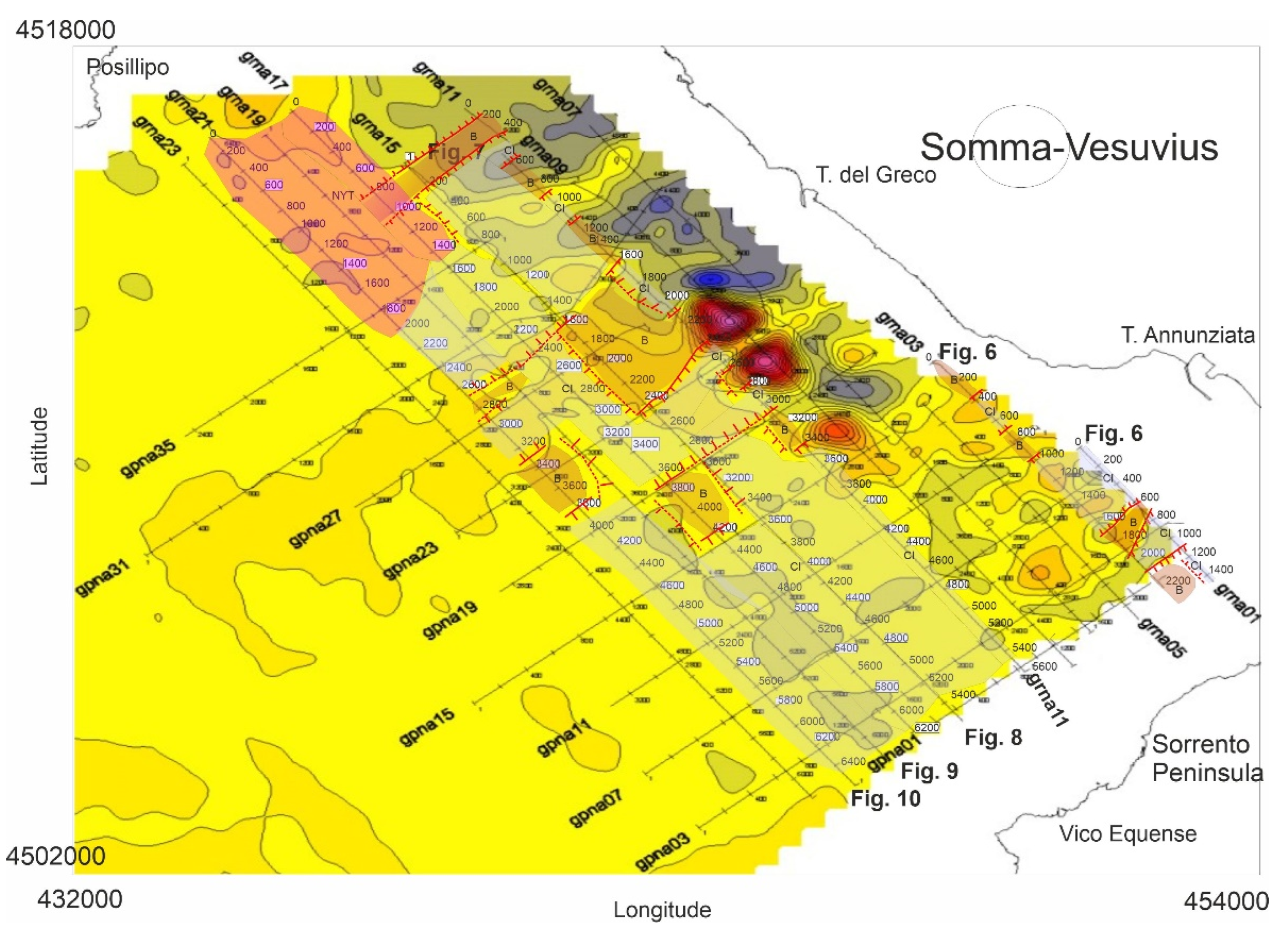
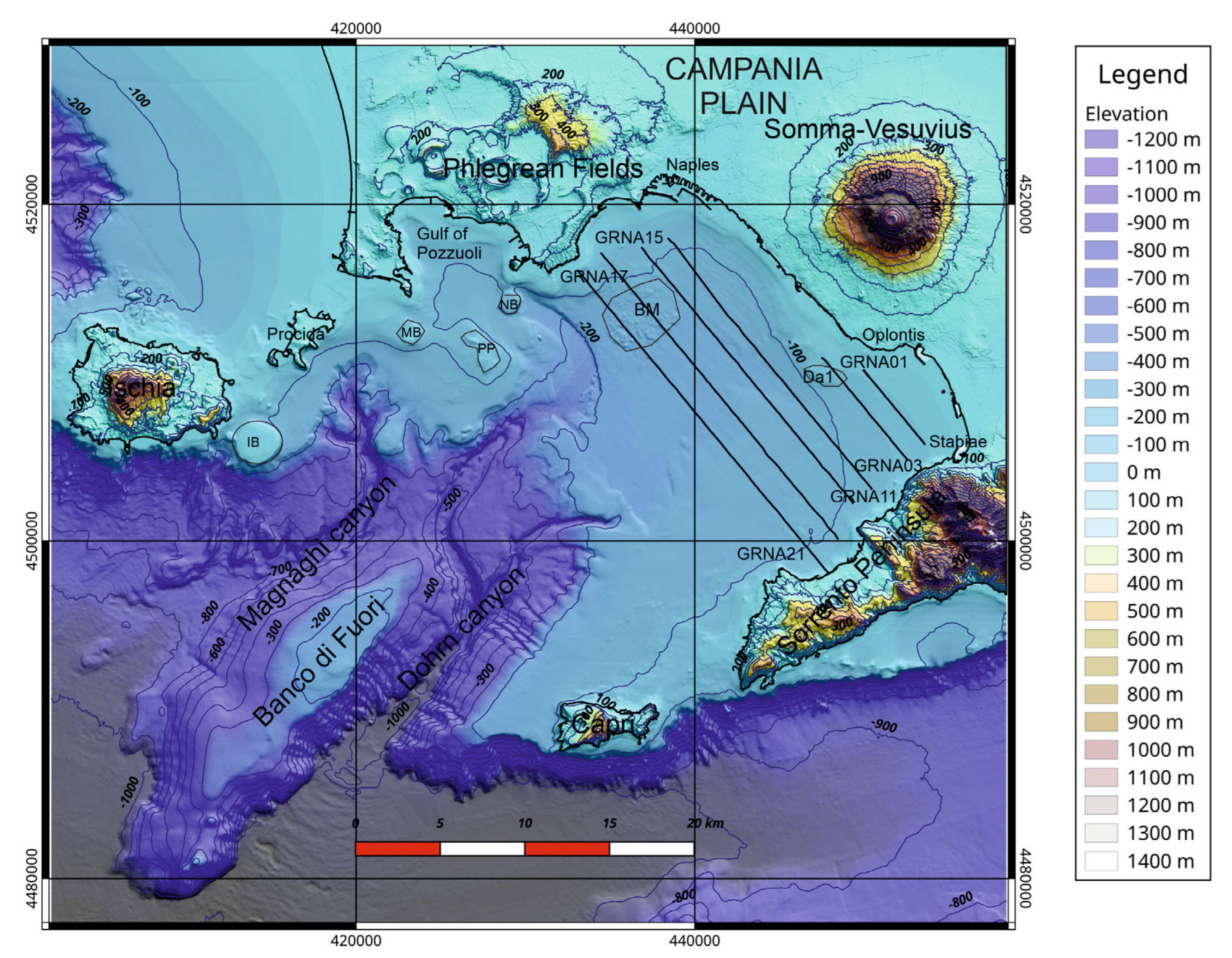
2. Datasets and Methods

A multibeam bathymetric dataset was previously acquired as part of the CARG project of the Naples and Salerno Bays (http://www.isprambiente.gov.it/Media/carg/campania.html, accessed on 16 October 2022; Figure 1) [29]. The DEM (Digital Elevation Model) merges onshore and offshore data and shows the location of the seismic lines analyzed in this paper (Figure 1). Onshore data display the physiographic domains of the Somma-Vesuvius volcanic complex, the Campi Flegrei volcanic complex, the Ischia and Capri islands, and the Sorrento Peninsula (Figure 1). The seismic lines analyzed in this paper are located in the eastern sector of the Bay of Naples, from the Somma-Vesuvius offshore to the Naples town (Posillipo), and from Sorrento Peninsula offshore, covering an inner shelf to outer shelf physiographic domain.
The seismic profiles were processed and interpreted with the aim of improving the geological knowledge of the eastern sector of Naples Bay, focusing in particular on the submarine flank of the Vesuvius volcano. The seismic data were collected previous to this study in the oceanographic cruise GMS00_05 [5], which took place during October–November 2000 in the Southern Tyrrhenian sea onboard of the R/V Urania (National Research Council of Italy). The seismic profiles GRNA01, GRNA03, GRNA11, GRNA17, and GRNA21, from the same cruise, are unpublished, and are herein processed and interpreted for the first time. The seismic profile GRNA15 was previously processed and interpreted by Aiello et al. [5] but is re-processed and re-interpreted here. Aiello et al. [5] provide additional details on the seismic acquisition parameters of the survey and methods for processing and interpretation of the seismic data.
The processing of the seismic lines was carried out using Seismic Unix software [30], including the extraction of the first channel from the shot gathers, application of Automatic Gain Control (AGC), and a spectral analysis of the seismic traces with a Fourier Transform and the application of a Butterworth bandpass filter (f = 40 Hz, 45 Hz, 240 Hz, 250 Hz).
The processing of the seismic data consisted of five steps. The first step was quality control and the assignment of the field geometry. The second step was editing the seismic traces to identify and remove spikes from the seismic record. The third step was top muting, to eliminate signals before the first arrivals of the seismic traces. The fourth step was the application of Automatic Gain Control (AGC), improving the normalization of the seismic traces. The fifth step was a velocity analysis aimed at removing move-out on the CDP (Common Depth Point) families and defining the velocity of the different seismic horizons. This yielded stacked seismic sections ready for the geological interpretation.
Geological interpretation of the seismic profiles was carried out using criteria of seismic stratigraphy [31,32,33]. A key concept is that the geometry of the seismic reflectors provides information on depositional geometry. Seismic reflectors correspond with significant contrasts in acoustic impedance, allowing for the calculation of transmitted vs. reflected acoustic energy. Seismo-stratigraphic analysis is carried out by identifying stratigraphic discontinuities and depositional sequences, reconstructing of the original geometry of the sedimentary bodies, and chronostratigraphic correlation. Planke et al. [34] developed the concept of the volcanic seismo-stratigraphy, which is the analysis of the seismic facies by mapping and geological interpretation of the units having the same seismic facies. However, individual volcanic deposits are sometimes difficult to image, requiring a knowledge of the seismic response of the different volcanic deposits.
In this paper, the identified seismic units are designated with letters, avoiding any lithostratigraphic or chronostratigraphic interpretation. Time-to-depth conversions of significant seismic reflectors were made, using an average velocity of the overlying Quaternary marine deposits of 1650 m/s. An average seismic wave velocity of 1650 m/s 1 within the first seismic units beneath the seafloor was assumed, as a result of test-calibration carried out in previous papers [35]. This conversion is necessary to allow the seismic reflector corresponding to the top of the seismic unit of the Campanian Ignimbrite, for example, to be correlated with the depth of these deposits at the “Trecase 1” exploration well [36] (Figure 2).

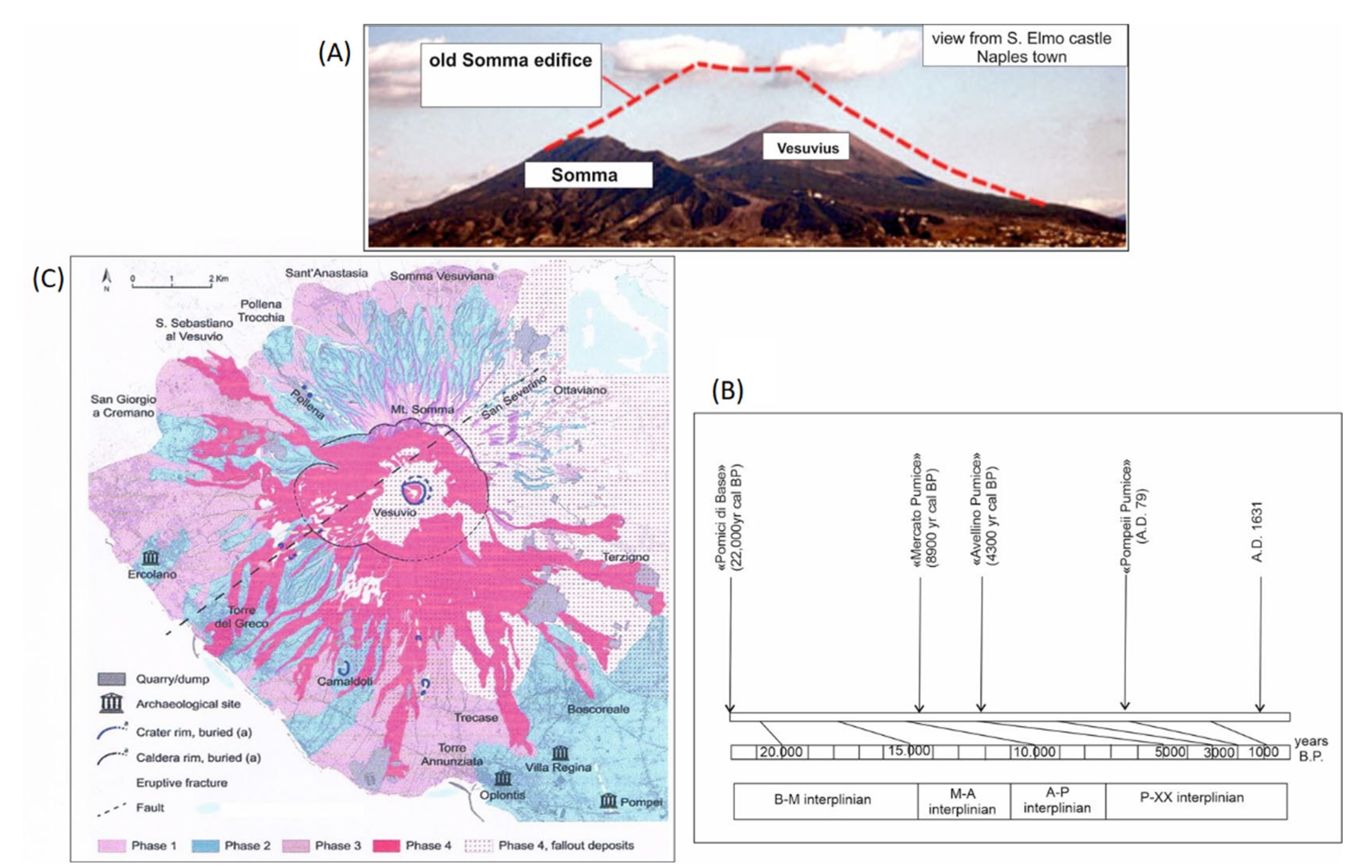
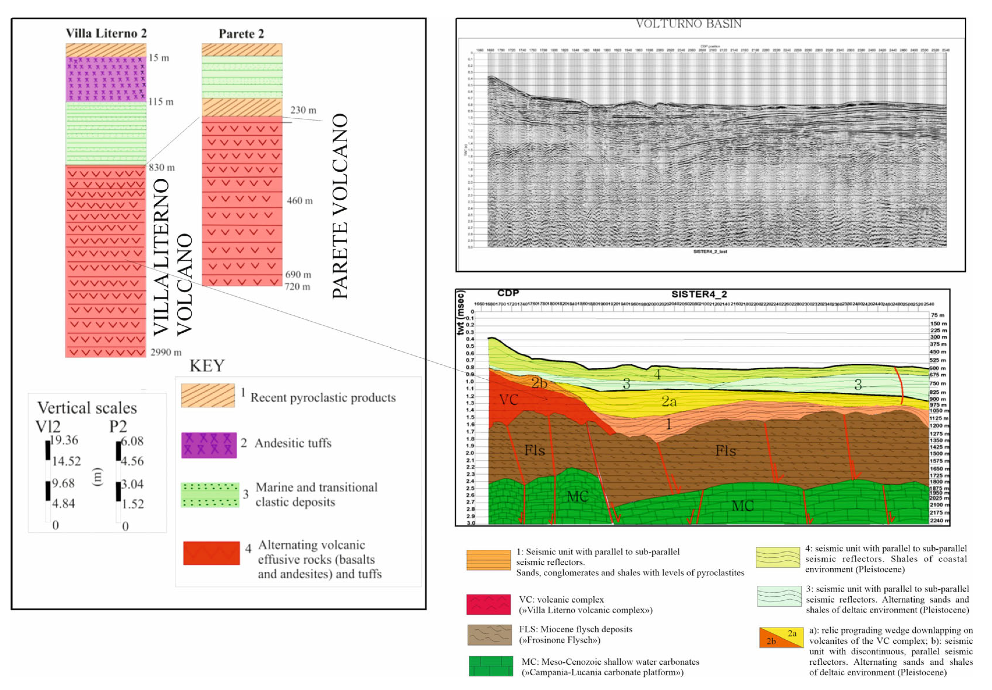
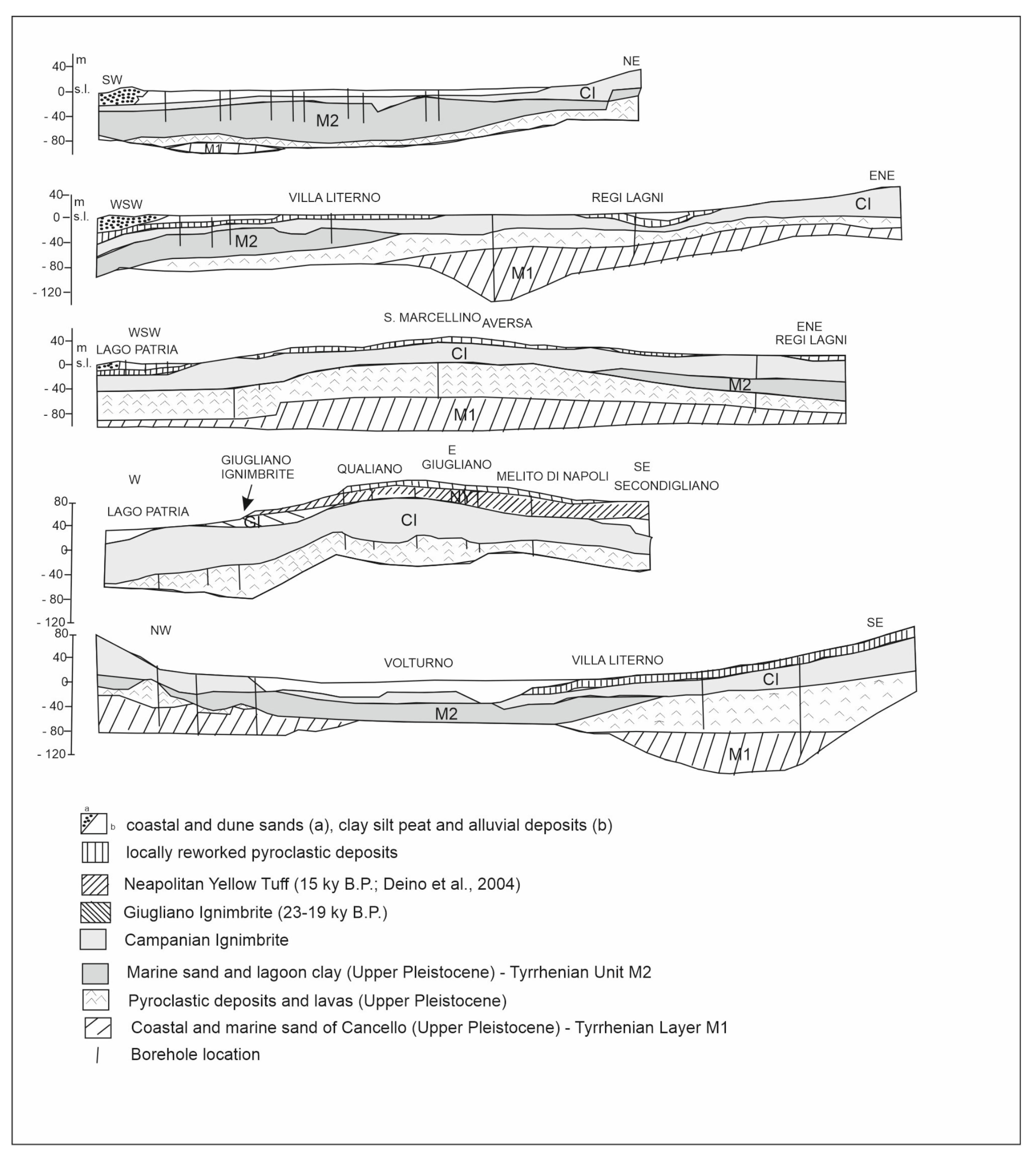
3. Geological Setting

The Bay of Naples lies in the southern part of a tectonic depression, namely the Campania Plain, produced by the regional tectonic subsidence that affected the Southern Tyrrhenian margin during the Pleistocene (Figure 1). It corresponds to a half-graben structure controlled by a NE-SW master fault running parallel to the “Banco di Fuori” structural high. The pre-Pleistocene basement crops out in the Sorrento Peninsula structural high. The age of basin formation is roughly Pleistocene based on the “Trecase 1” exploration well on land (Figure 2) [36]. A seismic profile located onshore in the Vesuvius area shows the main seismic reflectors (Figure 2) [2], corresponding with the acoustic basement, the faults mapped onshore in the volcanic complex [38], the seismic reflectors with a complex morphology, and the diffractions near the volcano (Figure 2).
The Quaternary volcanism of the Campania continental margin was controlled by three main rifting stages, allowing recognition of an ancient volcanic cycle, which was contemporaneous with the first rifting stage and of a young volcanic cycle, which acted simultaneously with the second and the third rifting stages [7]. This study established that the first rifting stage was Lower Pleistocene in age and was controlled by NE-SW trending normal faults. The second rifting stage, Middle Pleistocene in age, acted through NW-SE trending normal faults. The third rifting stage, Middle-Late Pleistocene in age, was controlled by the reactivation of previous fault systems and by N-S trending normal faults. The ancient volcanic cycle includes (among others) the V0 volcano [7] and the Parete volcano [39,40]. The volcanoes of the ancient cycle have a size comparable with that of the Somma-Vesuvius volcano and range in age between the Early Pleistocene and 0.4-0.1 My [7,41]. The Parete volcano is composed of thick basaltic and andesitic lavas, which were drilled by the “Villa Literno 2” and “Parete 2” wells [39,40,42] (Figure 3). The “Villa Literno 2” well has drilled the recent pyroclastic products, underlain by andesitic tuffs, having an average thickness of 150 m, underlain, in turn, by marine and transitional clastic deposits, thick about 650 m. These deposits overlie a thick volcanic sequence, composed of alternating lava and tuffs, thick about 2150 m, interpreted as the Villa Literno volcanic complex, recognized on the seismic profile Sister4_2 [39] and correlating with the “Parete 2” well (Figure 3). The “Parete 2” well has drilled a similar volcanic sequence, interpreted as the Parete volcano (Figure 3), and is overlain by recent pyroclastic products. The volcanoes of the young volcanic cycle include the lavas occurring in the subsurface of the Vesuvius volcanic complex (“Trecase 1” well) [35] (Figure 2), the Campanian Ignimbrite [11,13,43,44,45,46,47,48,49,50,51], and the eruptive sequence of the Vesuvius volcano (Figure 2).
In the northern Campania Volcanic Zone (CVZ), the stratigraphic data of more than 600 boreholes have allowed reconstruction of the stratigraphic architecture of the ignimbrite, lava flows, and marine deposits (Figure 4) [52]. The lowermost unit is composed of marine sediments (Tyrrhenian Layer M1), whose top was dated to 126 ky B.P. [53]. A volcanic unit overlies the marine deposits and is composed of massive ignimbrite deposits and lava flows. This unit is overlain by a succession of transitional and marine deposits, dated back to 55–50 ky (Tyrrhenian Unit M2) [54], overlain by the CI deposits [52,55,56,57,58,59,60]. The CI deposits are overlain by the Giugliano Ignimbrite (GI; Figure 4), while in the southern sector of the Campania Volcanic Zone, by grey Neapolitan Yellow Tuff (NYT) and by pyroclastic rocks younger than 10 ky.
The “Palazzo Reale borehole”, whose stratigraphy is shown in Figure 2, has given key lithostratigraphic data on the Neapolitan Yellow Tuff (NYT) and on the Campanian Ignimbrite (CI) in the subsurface of Naples [37,52]. It represents a key lithostratigraphic column, taken from a borehole 465 m deep and drilled in 1845 in Naples, near the garden of Palazzo Reale (Figure 2) [37,52]. The stratigraphic column of the well has revealed that, below 16 m of reworked deposits of recent activity of Campi Flegrei, a sequence of Neapolitan Yellow Tuff, about 90 m thick, overlies a sequence of the Campanian Ignimbrite, about 40 m thick (Figure 2). The CI overlies a sequence of tuffs about 80 m thick. Such stratigraphy can be assumed as continuous in the eastern sector of the Bay of Naples. Previous seismo-stratigraphic studies have shown acoustically transparent thick ignimbrite sequences below the Bay of Naples, interpreted as the Campanian Ignimbrite and the Neapolitan Yellow Tuff [14,59].
Campi Flegrei is a complex volcanic area, characterized by monogenetic volcanoes, pyroclastic in nature (tuff cones, tuff rings, ash cones, cinder cones, huge calderas) and subordinately, by lava domes [8,10,11,42]. This volcanic area is located at the southwestern margin of the graben of the Campania Plain, between the Massico Mount and the Sebeto Plain [60,61,62,63]. This area represents the emerged northern margin of the Phlegrean caldera, which formed about 39 ky B.P. after the eruption of the Campanian Ignimbrite and the consequent down throwing of the Meso-Cenozoic basement [8,9,10,11,64,65,66,67,68,69,70,71].
The Campi Flegrei volcanic district includes numerous tuff rings [11]. One of the most important ones is the tuff ring of Averno, whose volcanology was studied in detail [72]. The tuff ring of Averno was dated at 3700 years B.P. and is a wide maar-type, lake-filled volcano [72]. Di Vito et al. [11] showed the characteristics of the volcanic units of the Campi Flegrei caldera younger than 12 ky B.P. Based on their interpretation, several tuff rings were distinguished, including the Porto Miseno volcano and the Archiaverno volcano. The Porto Miseno volcano is located above the volcanic deposits of the Bacoli volcano and below the deposits of the Capo Miseno volcano.
Somma-Vesuvius is a stratovolcano constituted by an older breached edifice (Mt. Somma) and an intra-caldera cone (Figure 5A; Mt. Vesuvius) [38,73,74,75]. The volcanic succession is composed of lava flows, interlayered with strombolian scoria fall deposits overlain by the deposits of four main Plinian eruptions [73]:
(i)
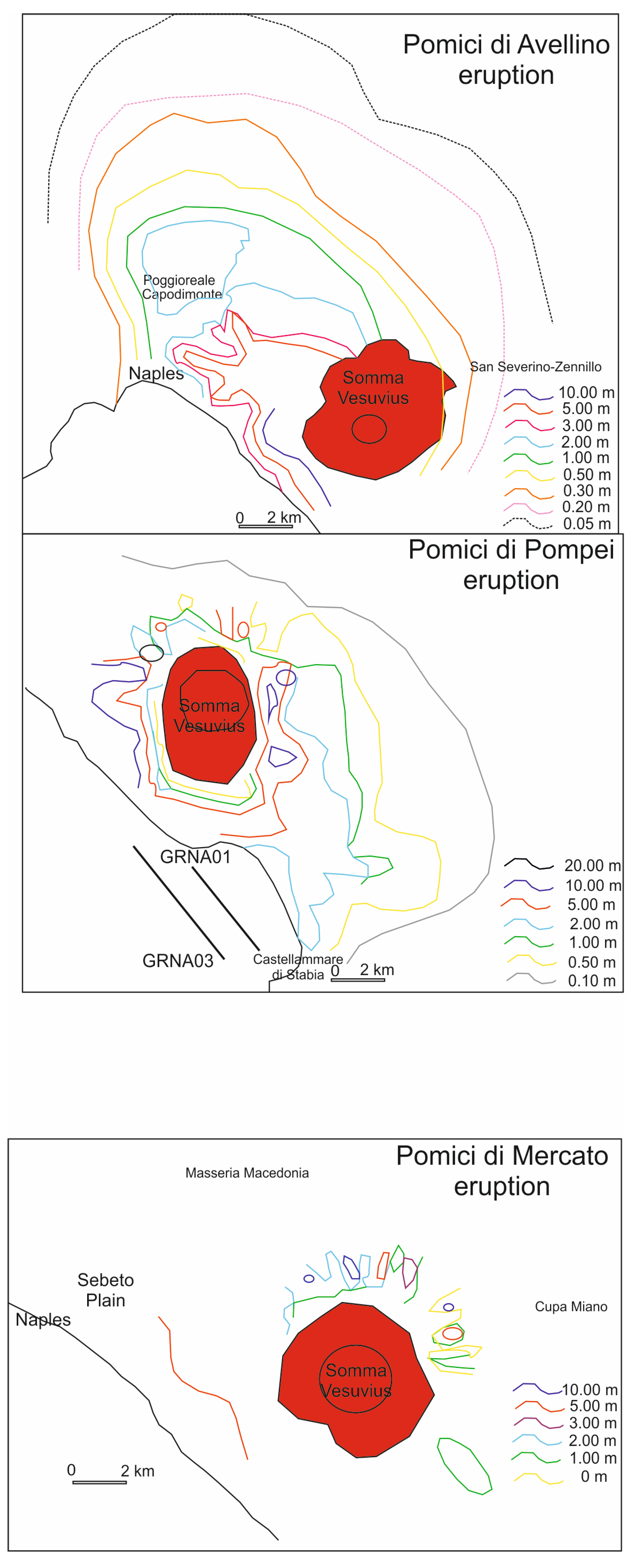
22,000 yr cal BP “Pomici di Base”;
(ii)
8900 yr cal BP “Mercato Pumice”;
(iii)
4300 yr cal BP “Avellino Pumice”; and
(iv)
A.D. 79 “Pompeii Pumice”.
The pyroclastic deposits corresponding with these four eruptions were interpreted as important stratigraphic markers (Figure 5B) [73]. These intervals, respectively, are:
(i)
B-M inter-Plinian, between “Pomici di Base” and “Mercato Pumice”;
(ii)
M-A inter-Plinian, between “Mercato Pumice” and “Avellino Pumice”;
(iii)
A-P inter-Plinian, between “Avellino Pumice” and “Pompeii Pumice”; and
(iv)
P-XX inter-Plinian, between the “Pompeii Pumice” and the last erupted products of the XXth century (Figure 5B) [73].
Moreover, a new geological map of the Somma-Vesuvius volcano at the 1:20,000 scale was recently constructed (Figure 5C) [75]. In this map, an interpretation of the volcanological evolution is shown, based on four main phases, including (Figure 5A): phase 1: the building of the Somma stratovolcano (39 ky–22 ky); phase 2: the caldera formation (22 ky–AD 79); phase 3: the post-caldera activity (AD 472–AD 1631); and phase 4: the growth of the Vesuvius cone (post-1631–1944). During the second phase, a multiphase caldera formation took place, following the emplacement of at least four Plinian eruptions (Pomici di Base, Mercato, Avellino, and Pompeii). During the third phase, the post-caldera activity took place, which was dominated by the deposits of two sub-Plinian eruptions: AD 472 Pollena (PPL) and AD 1631 (PMX). During the fourth phase, the Vesuvius cone grew (post-1631–1944), with the effusion of lavas and volcanic eruptions of a strombolian-type. The corresponding volcanic deposits are represented by wide lava flows, overlying the southwestern slopes of Vesuvius [75].

4. Results

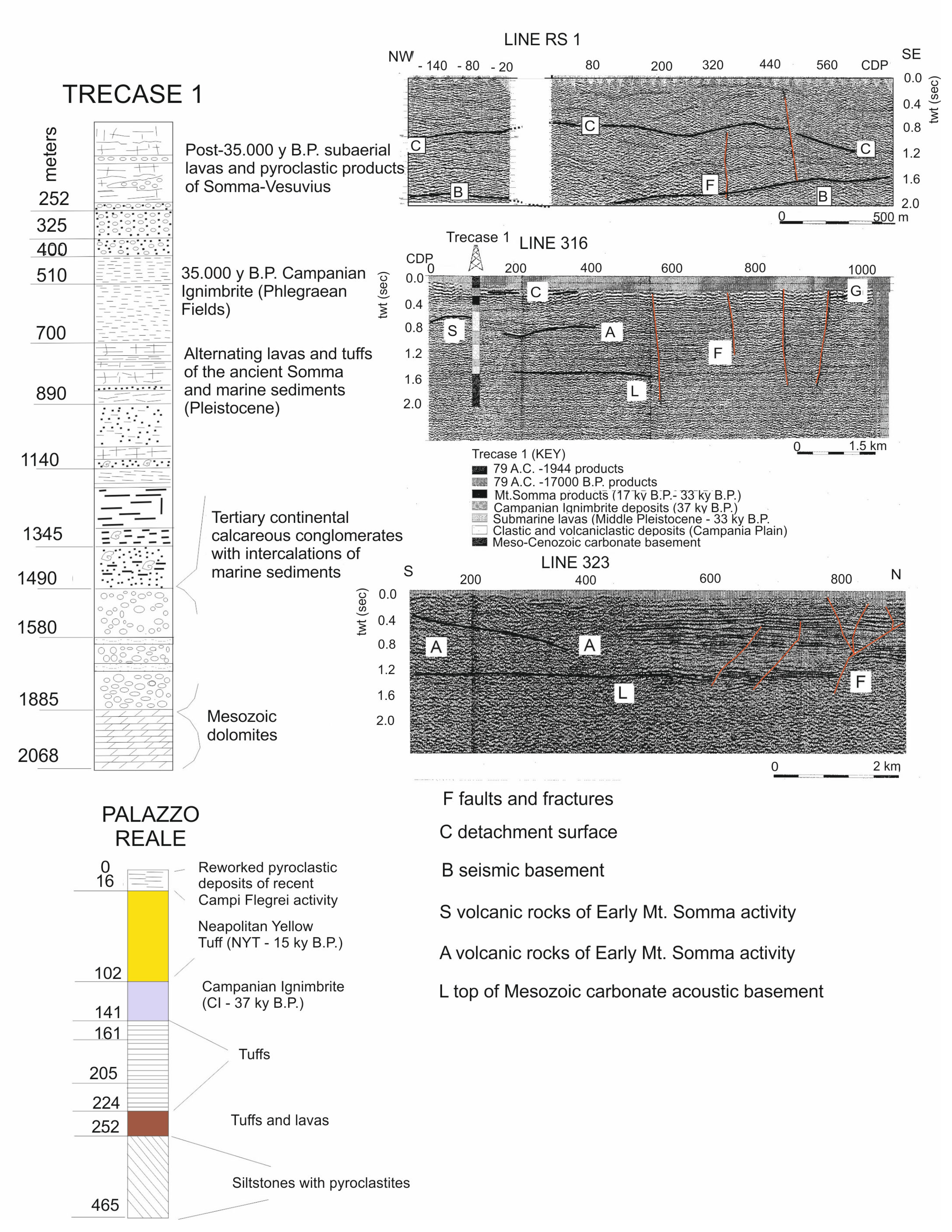
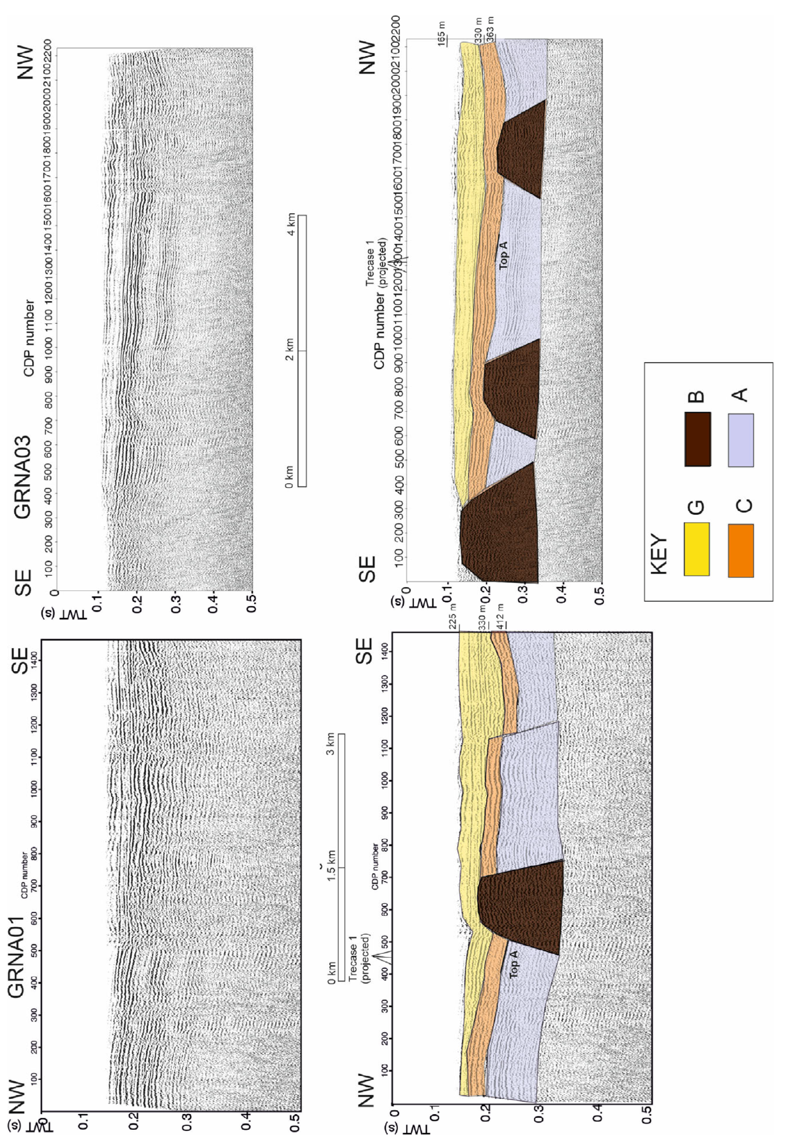
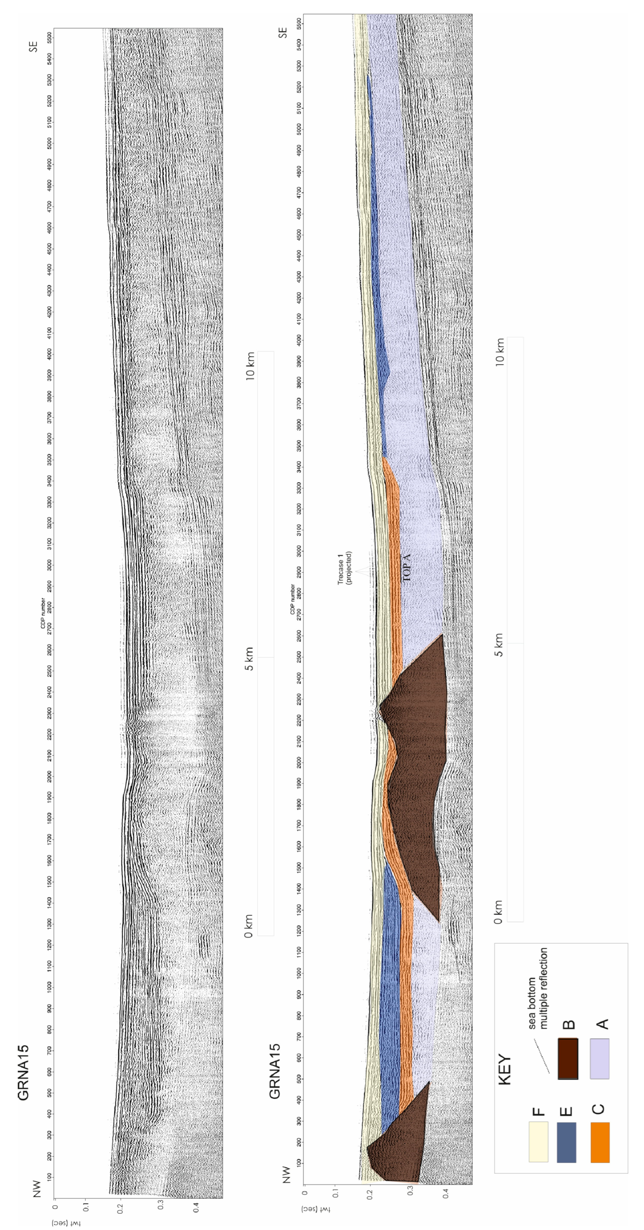
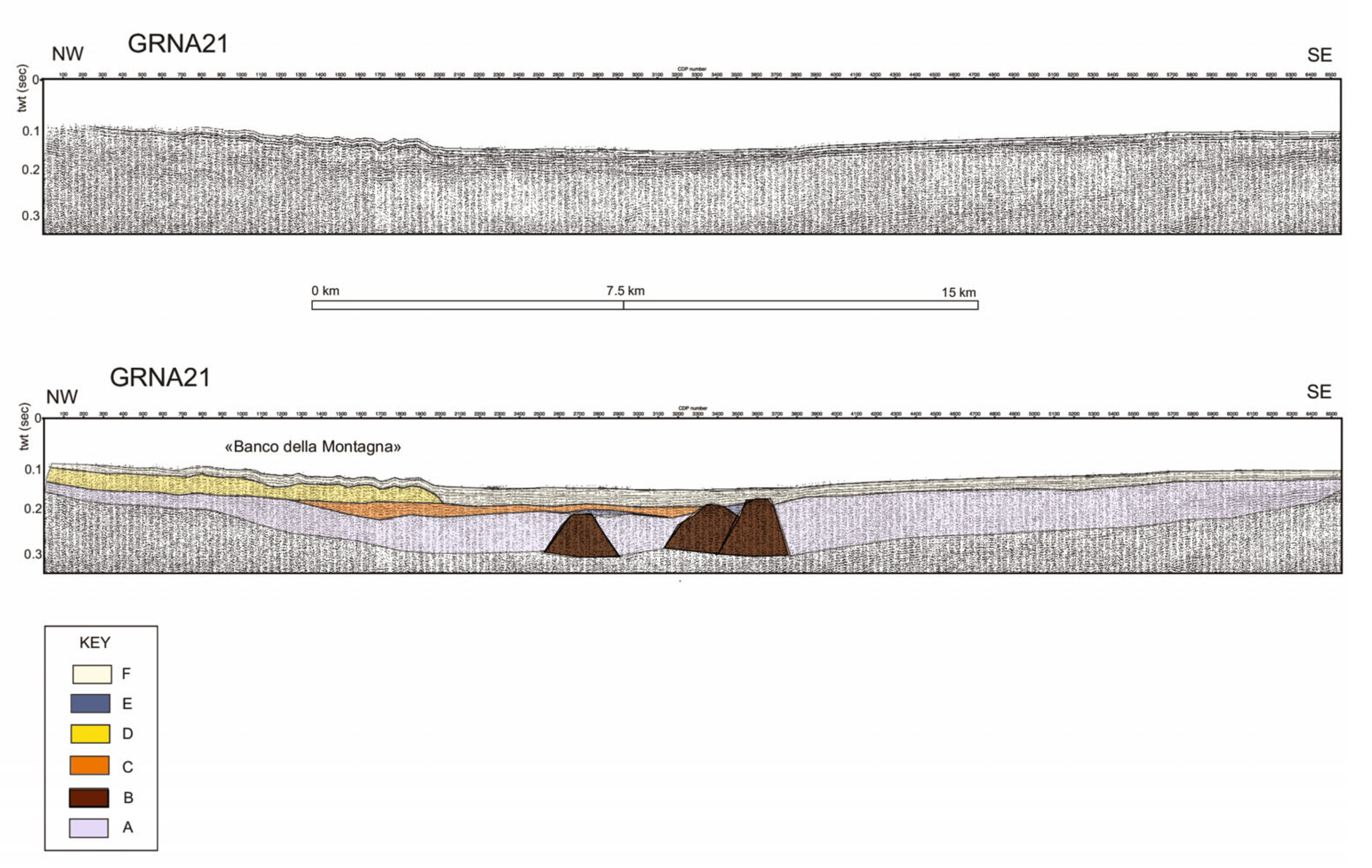
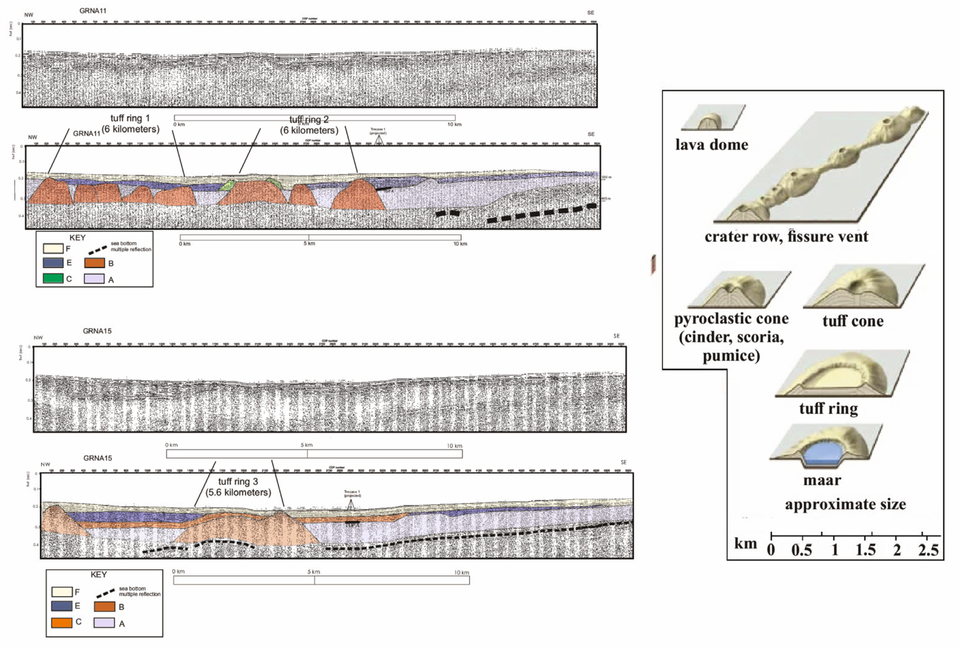
4.1. Description of the Seismic Units

Seven seismic units (A, B, C, D, E, F, G) are identified on the seismic profiles of the eastern Bay of Naples based on the seismic stratigraphic and volcano-stratigraphic interpretation (Table 1, Figure 6, Figure 7, Figure 8, Figure 9 and Figure 10). The G unit is recognized on the seismic profiles GRNA01 and GRNA03 (Figure 6). Its seismic facies is characterized by discontinuous, undulated, and wavy seismic reflectors. Moreover, the seismic unit shows thickness variations. The F unit is identified on the seismic profiles GRNA11, GRNA15, GRNA17, and GRNA21 (Figure 7, Figure 8, Figure 9 and Figure 10). Its seismic facies is distinguished by parallel and continuous seismic reflectors, while the unit shows a wedge-shaped external geometry. The E unit is identified on the seismic sections GRNA11, GRNA15, and GRNA21 (Figure 7, Figure 8 and Figure 10). It is characterized by discontinuous and parallel seismic reflectors and shows thickness variations. The D unit is recognized on the seismic profiles GRNA17 and GRNA21 (Figure 9 and Figure 10). Its seismic facies is acoustically-transparent and it is characterized by a wedge-shaped geometry. The C unit is identified on the seismic sections GRNA01, GRNA03, GRNA11, GRNA17, and GRNA21 (Figure 6, Figure 7, Figure 9 and Figure 10). Its seismic facies shows two sub-facies, the first one with parallel and continuous seismic reflectors and the second one with progradational reflectors. The B unit is an important volcanic seismic unit and is recognized in all the studied sections (Figure 6, Figure 7, Figure 8, Figure 9 and Figure 10). Its seismic facies is acoustically transparent and the geometry is mounded-shaped. The A unit is another important volcanic seismic unit and is identified in all the studied sections (Figure 6, Figure 7, Figure 8, Figure 9 and Figure 10). Its seismic facies is acoustically-transparent, while its shape is tabular (Table 1).
The 6 km long Grna01 seismic profile (Figure 6) is located offshore the Vesuvius volcano and crosses the easternmost sector of Naples Bay with an NW-SE trend (Figure 1). Four seismic units are recognized based on seismic facies and strata patterns: (G, C, B, A units; Figure 6). Based on the time-to-depth conversion of the seismic reflector corresponding to the top of the A seismic unit, this seismic reflector is located at a depth of about 412 m, which is in overall agreement with the depth of the Campanian Ignimbrite at the “Trecase 1” borehole (400 m; Figure 2). One mounded-shaped structure, composed of the B unit, is recognized. Proceeding from northwest to southeast, a significant thickness variation of the G seismic unit is observed, since the G unit increases in thickness (Figure 6).
The Grna03 seismic profile (Figure 6) has a length of about 8 km and crosses the eastern sector of Naples Bay with a NW-SE trend (Figure 1). The top of the A unit occurs at depths of 363 m (Figure 6), being in agreement with the depth of the top of the Campanian Ignimbrite unit at the “Trecase 1” borehole (400 m; Figure 2). Three mounded-shaped seismic structures, composed of the B unit, are recognized (Figure 8). The C unit drapes two of these three structures, while it onlaps the flank of the southeastward one (Figure 6). Proceeding from southeast to northwest, a thickness variation of the G unit is observed (Figure 6).
The Grna11 seismic profile (Figure 7) has a length of about 20 km and crosses the eastern Bay of Naples with a SE-NW trend (Figure 1).
Five seismic units are identified (A, B, C, E, F; Table 1; Figure 7). The E unit is located in depressions located between the seismic structures composed of the B unit or alternatively, at the top of the A unit (Figure 7).
The top of the A unit occurs at depths ranging between 330 m and 400 m (Figure 7), showing a good correlation with the top of the Campanian Ignimbrite (400 m; Figure 2).
Three broad seismic structures are recognized, composed of the B unit, respectively, having three mounds northwestwards, one mound at the center, and one mound southeastwards (Figure 7).
The C seismic unit has a progradational seismic facies and overlies the flanks of the mounded-shaped seismic structure composed of the B unit.
The E unit is extensive and in the northwest sector covers the volcanic edifices of the B unit, while in the southeast, it overlies the top of the A unit (Figure 7).
A part GRNA01 and GRNA03 (Figure 6), the F seismic unit is tabular in shape and was detected in all the seismic lines (Figure 7).
The Grna15 seismic profile (Figure 8) has a length of about 20 km and extends from Naples to the Sorrento offshore (Figure 1).
Five seismic units (A, B, C, E, F; are recognized) (Table 1; Figure 8).
The E unit is located in a depression between two seismic structures of the B unit, and on the top of the A unit (Figure 8).
The C unit is located in a depression on the B unit and on the top of the CI unit. Time-to-depth conversion yields a value of 462 m for the depth to the top of the A unit. This value is in agreement with the depth of the top of the Campanian Ignimbrite at the “Trecase 1” well (400 m; Figure 2).
The Grna17 profile (Figure 9) has a NW-SE orientation and a length of about 22 km, extending from the Naples offshore (Posillipo hill) to the Sorrento Peninsula offshore (Figure 1).
Five seismic units are identified based on seismic interpretation (A, B, C, D, F).
The D unit is recognized offshore the city of Naples, unconformably overlying both the B and the C seismic units (Figure 9).
The C unit is deposited in a depression located at the top of the A unit, which is laterally bounded by the D and B seismic units.
The B unit includes a small seismic structure below the D unit and two wider seismic structures inter-layered in the A unit (Figure 9).
The Grna21 profile (Figure 10) crosses the Naples offshore from Posillipo to the Sorrento Peninsula (Figure 1). Six seismic units are recognized based on seismic interpretation (A, B, C, D, E, F; Table 1; Figure 10). D unit is deformed in the “Banco della Montagna” feature, a wide volcaniclastic field previously described in the Naples offshore [6,59,76,77]. The C unit is located in a depression, located at the top of the A unit and is laterally bounded by a seismic structure of the B unit. The E unit forms small deposits located at the top of B unit. The B unit includes three seismic structures (Figure 10). The A unit is wide and thick in this seismic line (Figure 10).

4.2. Geological Interpretation of the Seismic Units

The G unit is identified on both the Grna01 and Grna03 seismic lines (Figure 6). The G unit could comprise volcanic deposits older than AD 79 and apparently capped by eruption deposits dated at their base.
The G unit probably represents pyroclastic flow deposits from Vesuvius, based on its location only offshore of Somma-Vesuvius and by the discontinuous and undulated character of the seismic reflectors. This interpretation is supported by the qualitative correlation with previous core sampling in the area, which have cored the fallout deposits of the AD 79 in the upper meters of the seismic unit [4], but the thickness of the seismic unit is much larger than the thickness of the AD 79 deposits.
Thus, the G unit is interpreted to mainly consist of PDCs of pre-AD 79 Plinian eruptions. Figure 11 shows the isopach maps of “Pomici di Avellino”, “Pomici di Pompei”, and “Pomici di Mercato” eruptions [25].
In that paper, the authors discussed the dispersal, thickness, and extent of the PDC deposits, which were generated during seven plinian and sub-plinian eruptions (Pomici di Base, Greenish Pumice, Pomici di Mercato, Pomici di Avellino, Pompeii Pumice, AD 472 Pollena, and AD 1631 eruptions).
The isopach maps and the facies character reveal that the dispersal of the PDCs from Vesuvius was mainly controlled by the intensity of the eruption, by the location of the vent with respect to the Mt. Somma caldera and by the inherited topography. The most widely dispersed volcanic deposits are those of the Pomici di Avellino and Pomici di Pompei. In these maps, the isopachs of the volcanic deposits, reported in meters, indicate that they projected eastwards, not toward the Bay of Naples (Figure 11).
Based on the data of Gurioli et al. [25], the volcanic deposits of the Pomici di Mercato eruption are mainly located on the northern slopes of Mt. Somma, highlighting that the vent location was similar to that one of the present-day Vesuvius (Figure 11).
The Pomici di Avellino deposits reach their maximum thickness in the western sector of Vesuvius and are characterized by a strong facies variability. They are recognized as far as 25 km from the inferred vent, which was probably eccentric with respect to the volcano. Based on these data, the G unit is likely correlated with the volcanic deposits derived from the oldest plinian eruptions (Avellino, Mercato, and Pomici di Base).
The F and C units are recognized in the whole study area (Table 1; Figure 6, Figure 7, Figure 8, Figure 9 and Figure 10) and are interpreted as highstand (HST) and lowstand (LST) system tract deposits from the Late Quaternary. The highstand deposits (HST) are younger than the phase of maximum marine ingression (about 4–5 ky B.P.) and were described in previous papers on the Bay of Naples [4]. The C unit, which is composed of lowstand deposits, was alsofound both in depressions between the buried tuff rings of the B unit and at the top of the A unit (Figure 6, Figure 7, Figure 8, Figure 9 and Figure 10). The lowstand deposits (LST) were formed during the sea level lowstand during the last Quaternary glacial episode (isotopic stage 2) [54].
The D unit is identified on the seismic profiles Grna17 and Grna21 (Table 1; Figure 9 and Figure 10). This unit is interpreted as the submarine extent of the Neapolitan Yellow Tuff (NYT) deposits, which underlie Naples and cropping out widely in the adjacent Posillipo hill. The NYT was emplaced during the second phreato-magmatic eruption from the Phlegraean caldera and crops out over an area of 1000 km2 [8,9,10,11,16,18,67,68,70].
The NYT deposits were identified in the Gulf of Pozzuoli and in the northern Phlegraean Fields offshore [12,14,20,58,78,79,80]. Pyroclastic deposits represent main stratigraphic markers in the marine sedimentary record [81,82,83] and were documented on the Campania continental margin [84,85,86,87,88]. A continuous seismic reflector mapped in the northern Phlegraean offshore was correlated with the NYT deposits [21]. This horizon is inter-layered in transgressive deposits, which are thicker than those detected in other Campania outer shelf settings, as a consequence of a high input of pyroclastic and volcaniclastic deposits, related to the eruptive activity of the Campania Plain during the Late Pleistocene-Holocene.
The E unit (Table 1; Figure 7, Figure 8 and Figure 10) is found in depressions located between the buried tuff rings composed of the B unit or at the top of the A unit. Based on its location and on the seismic facies, characterized by discontinuous, sub-parallel seismic reflectors, the E unit is interpreted as a widely distributed debris flow unit, whose deposition is possibly related to eruptive processes in the Somma-Vesuvius offshore. Sulpizio et al. [89] have shown onshore stratigraphic data contrasting the occurrence of a large debris avalanche, which occurred just before the Avellino eruption of the Somma-Vesuvius volcano [90]. Indeed, volcaniclastic mass flows often occurred during the geological past and are characterized by rain-triggered debris flows and hyperconcentrated flows. These volcaniclastic deposits crop out widely along the cliffs of the western coastline and are separated by paleosols or erosional surfaces [89]. The volcaniclastic deposits ascribed to debris flows are coarse-grained and rich in lithic blocks, and are correlated with the pyroclastics with lava blocks of the Herculaneum log [90]. Based on these data, the E unit could represent a volcaniclastic mass flow, which occurred in the geological past, possibly after the eruption of the Campanian Ignimbrite (A unit) or after the emplacement of the B unit, interpreted as buried tuff rings [11,72].
The B seismic unit (Table 1; Figure 6, Figure 7, Figure 8, Figure 9 and Figure 10) was previously interpreted as buried volcanic mounds [5] or cryptodomes [1] genetically related to Somma-Vesuvius eruptive activity. However, this interpretation needs be re-examined. For example, the height-to-width ratio of these bodies is very low (possibly 1:15–1:20), which seems more consistent with an interpreted of them as tuff rings, although they do not show any crater-related depressions, which should be evident in these edifices. This geological interpretation is supported by the width of the volcanic edifices (up to several km) and by comparison with similar volcanic edifices recognized in the Neapolitan area [11,72]. Figure 12 compares the structures of the B unit in seismic profiles GRNA11 and GRNA15 with the general types of volcanic edifices (lava dome, crater row, fissure vent, pyroclastic cone, tuff cone, tuff ring, maar). On the seismic profile GRNA11, two volcanic edifices, interpreted as tuff rings, are identified; both with a width of 6 km (tuff rings 1 and 2). On the seismic profile GRNA15, tuff ring 3 has a width of 5.6 km (Figure 12). The dimensions of the volcanic edifices, as measured on the seismic sections, are compatible with those of tuff rings recognized in the Neapolitan area and described in previous geological literature (Figure 12).
The A seismic unit (Table 1; Figure 6, Figure 7, Figure 8, Figure 9 and Figure 10) is an important seismic unit in the stratigraphic architecture of the Bay of Naples. Due to its stratigraphic location and based on previous geological literature [7,59,91,92], it can be correlated with the Campanian Ignimbrite pyroclastic flow deposits. Based on literature data, this unit is important because it was identified in the whole subsurface of the eastern Bay of Naples [7,59,91,92]. The Campanian Ignimbrite is composed of thick pyroclastic deposits, trachytic and phonolitic in composition, and genetically related to a collapsed caldera [8,9,10,11,13,47,50,66,67,68,69,70,93,94].

5. Discussion and Conclusions

Seven seismic units were identified on the multichannel seismic lines presented in this paper (Figure 6, Figure 7, Figure 8, Figure 9 and Figure 10), namely the G (pyroclastic flows of Vesuvius), F (highstand deposits), E (debris flows of Vesuvius), D (Neapolitan Yellow Tuff), C (lowstand deposits), B (buried tuff rings), and A (Campanian Ignimbrite) seismic units.
The seismo-stratigraphic data analyzed in this paper (Figure 6, Figure 7, Figure 8, Figure 9 and Figure 10) can be interpreted as a succession of events for the eastern sector of the Naples Bay, referring, in particular, to the Somma-Vesuvius offshore area. The seismic profiles show a low seismic unit with an acoustically transparent seismic facies (A), corresponding to the 39 ky-old Campanian Ignimbrite and another acoustically-transparent seismic unit (B), located seawards that underlies the C unit (lowstand deposits) and is overlain by the F unit (highstand deposits; Figure 6, Figure 7, Figure 8, Figure 9 and Figure 10).
The seismic unit B is interpreted as buried tuff rings. This interpretation is supported by the fact that tuff rings are abundant in the Neapolitan area [11,72]. For example, after the eruption of the Neapolitan Yellow Tuff (15 ky B.P.), the volcanic activity of Campi Flegrei volcanic complex was characterized by hydromagmatic phenomena, and by minor effusive activity forming lava domes. In the caldera of the Neapolitan Yellow Tuff, volcanism created numerous monogenetic vents, including tuff rings, tuff cones, cinder and spatter cones [11,72,95,96,97,98]. Among them, the tuff ring of Averno (3700 years BP) is interpreted as a maar-type, lake-filled volcano, formed during an explosive eruption of Campi Flegrei [72]. The Averno tuff ring is circular, with a rim diameter of 1.5 km, overlying an irregular topography composed of relicts of the earlier Archiaverno tuff ring [11]. Other significant tuff rings of the Neapolitan area were described by Di Vito et al. [11], discussing the characteristics of the main volcanic units of the Campi Flegrei caldera, younger than 12 ky B.P.
In proximal domains, the C unit is overlain by a chaotic seismic unit interpreted as formed by the volcanic deposits older than the AD 79 pyroclastic flow deposits (G; the pyroclastic deposits representing the base of this eruption; Figure 11) [25]. The G unit is an important seismic unit in the stratigraphic architecture of the eastern Naples Bay (Figure 6). The G unit is composed of some of the PDCs older than the AD 79 volcanic deposits. Previous studies on the geological setting of the Bay of Naples offshore the Sarno prodelta have documented the stratigraphic signature of the tephra deposit erupted by the Vesuvius volcano during the AD 79 volcanic event [4]. Moreover, the isopach maps of the PDCs constructed by Gurioli et al. [25] were used to check the correlation of this seismic unit with some of the PDCs older than AD 79 volcanic deposits (Figure 11) and have confirmed this interpretation. Figure 11 reports the isopach maps of Pomici di Avellino, Pompei, and Pomici di Mercato eruptions [25]. Based on the data of Gurioli et al. [25], five of the seven Vesuvius plinian and sub-plinian eruptions (Pomici di Base, Greenish Pumice, Pomici di Mercato, Pomici di Avellino, Pompeii Pumice, AD 472 Pollena, and AD 1631 eruptions) have dispersed PDCs radially and their dispersion was controlled by the location of the vent and by the palaeo-topography. The most dispersed deposits are those of the Pomici di Avellino and Pompeii Pumice, extending more than 20 km from the inferred vent [25]. The maximum thickness of Pomici di Mercato is 18 m (measured to the north), while the maximum thickness of Pomici di Avellino is 22 m (measured to the west). The isopach map of the Pomici di Mercato eruption has shown that these deposits are mainly located along the northern slopes of Mt. Somma, and that the corresponding vent was located in a location similar to that one of the Vesuvius. The isopach map of the Pomici di Avellino eruption has shown that they have their maximum thickness in the western sector of the volcano and are characterized by important lateral variations in lithofacies and thickness [99]. Sulpizio et al. [99] studied the sedimentology and the physical volcanology of the Pomici di Avellino eruption through field and laboratory studies, establishing five eruptive units (EUs), which emplaced during an opening, Plinian and final phreatomagmatic phase of this eruption. The PDCs of the Avellino eruption were erupted during EU1, EU2, EU3, EU4, and EU5 with different eruptive mechanisms.
Due to its seismic facies and to the stratigraphic relationships, the C unit is interpreted as the lowstand system tract (LST) deposits, i.e., the sediments that were deposited during the falling and lowstand of sea level. These deposits were disturbed by the eruption of the D unit, interpreted as the Neapolitan Yellow Tuff deposits (15 ky B.P.).
The seismo-stratigraphic analysis of multichannel profiles calibrated with gravity cores offshore the Vesuvius volcano and Posillipo hill has highlighted new implications for the Quaternary volcanism of the Campania continental margin. Multichannel seismic lines are interpreted to study the stratigraphic relationships between the Quaternary marine deposits deposited in this area and the volcanic acoustic substratum (A and D units). The volcano structure is controlled by NE-SW trending seismic structures, suggesting a volcano–structural correlation with the regional faults occurring in this area [100,101]. These structures correspond with tuff rings composed of the B unit, which underlie the lowstand deposits and seem to be younger than the A unit. The tuff rings seem to be younger than 37 ky B.P. (A unit) and older than 18 ky B.P. (approximate lower boundary of the lowstand deposits of the C unit).
The total magnetic field offshore the Somma-Vesuvius volcanic complex (Figure 13) shows that the shape of the anomaly is dipolar. There is no apparent effect caused by the occurrence of remnant magnetization with respect to that of the present-day main field. NE-SW trending seismic structures identified based on seismic data represent a preferential pathway of magma uprising for Vesuvius volcano. These structures mainly occur offshore of the Torre del Greco and the Torre Annunziata towns and are evident on the sketch magnetic map of Figure 13, which includes the tuff rings shown in this paper and the A and D seismic units. The geological structures identified through seismic interpretation are located in a complex magnetic anomaly area (Figure 13), which is made up of several anomalies, reaching a maximum intensity of 400 nT. This area represents the offshore prolongation of the Vesuvius volcano. The seismo-stratigraphic data suggest a close relationship between the seismic structures offshore the volcano and in the eastern sector of the gulf, and the structural setting of the Naples Bay, controlled by NE-SW trending (counter-Apenninic) regional faults (Figure 13).

Funding

This research received no external funding.

Institutional Review Board Statement

Not applicable.

Informed Consent Statement

Not applicable.

Conflicts of Interest

The authors declare no conflict of interest.

References

  1. Milia, A.; Mirabile, L.; Torrente, M.M.; Dvorak, J.J. Volcanism offshore of Vesuvius volcano in Naples Bay. Bull. Volcanol. 1998, 59, 404–413. [Google Scholar] [CrossRef]
  2. Bruno, P.P.G.; Rapolla, A. Study of sub-surface structure of Somma-Vesuvius (Italy) by seismic reflection data: Implications for Campanian volcanism. Tectonophysics 1999, 372, 193–213. [Google Scholar] [CrossRef]
  3. Milia, A.; Torrente, M.M.; Bellucci, F. A possible link between faulting, cryptodomes and lateral collapses at Vesuvius Volcano (Italy). Glob. Planet. Change 2012, 90–91, 121–134. [Google Scholar] [CrossRef]
  4. Sacchi, M.; Insinga, D.D.; Milia, A.; Molisso, F.; Raspini, A.; Torrente, M.M.; Conforti, A. Stratigraphic signature of the Vesuvius 79 AD event off the Sarno prodelta system, Naples Bay. Mar. Geol. 2005, 222–223, 443–469. [Google Scholar] [CrossRef]
  5. Aiello, G.; Angelino, A.; D’Argenio, B.; Marsella, E.; Pelosi, N.; Ruggieri, S.; Siniscalchi, A. Buried volcanic structures in the Gulf of Naples (Southern Tyrrhenian sea, Italy) resulting from high resolution magnetic survey and seismic profiling. Ann. Geophys. 2005, 48, 1–15. [Google Scholar]
  6. Passaro, S.; Sacchi, M.; Tamburrino, S.; Ventura, G. Fluid Vents, Flank Instability, and Seafloor Processes along the Submarine Slopes of the Somma-Vesuvius Volcano, Eastern Tyrrhenian Margin. Geosciences 2018, 8, 60. [Google Scholar] [CrossRef] [Green Version]
  7. Milia, A.; Torrente, M.M. Space-time evolution of an active volcanic field in an extensional region: The example of the Campania margin (eastern Tyrrhenian Sea). In Vesuvius, Campi Flegrei, and Campanian Volcanism, 1st ed.; De Vivo, B., Belkin, H., Rolandi, G., Eds.; Elsevier: New York, NY, USA, 2020; pp. 297–321. [Google Scholar]
  8. Rosi, M.; Sbrana, A. Phlegrean Fields; Consiglio Nazionale delle Ricerche, Quaderni de La Ricerca Scientifica: Rome, Italy, 1987. [Google Scholar]
  9. Scandone, R.; Bellucci, F.; Lirer, L.; Rolandi, G. The structure of the Campanian Plain and the activity of the Neapolitan volcanoes (Italy). J. Volcanol. Geoth. Res. 1991, 48, 1–31. [Google Scholar] [CrossRef]
  10. Orsi, G.; De Vita, S.; Di Vito, M. The restless, resurgent Campi Flegrei nested caldera (Italy): Constraints on its evolution and configuration. J. Volcanol. Geoth. Res. 1996, 74, 179–214. [Google Scholar] [CrossRef]
  11. Di Vito, M.A.; Isaia, R.; Orsi, G.; Southon, J.; De Vita, S.; D’Antonio, M.; Pappalardo, L.; Piochi, M. Volcanism and deformation since 12,000 years at the Campi Flegrei caldera (Italy). J. Volcanol. Geoth. Res. 1999, 91, 221–246. [Google Scholar] [CrossRef]
  12. Aiello, G.; Marsella, E.; Di Fiore, V. New seismo-stratigraphic and marine magnetic data of the Gulf of Pozzuoli (Naples Bay, Tyrrhenian sea, Italy): Inferences for the tectonic and magmatic events of the Phlegrean Fields volcanic complex (Campania). Mar. Geophys. Res. 2012, 33, 93–125. [Google Scholar] [CrossRef] [Green Version]
  13. Fitzsimmons, K.E.; Hambach, U.; Veres, D.; Iovita, R. The Campanian Ignimbrite Eruption: New Data on Volcanic Ash Dispersal and Its Potential Impact on Human Evolution. PLoS ONE 2013, 8, e65839. [Google Scholar] [CrossRef] [PubMed]
  14. Aiello, G.; Giordano, L.; Giordano, F. High-resolution seismic stratigraphy of the Gulf of Pozzuoli (Naples Bay) and relationships with submarine volcanic setting of the Phlegrean Fields volcanic complex. Rend. Lincei Sci. Fis. E Nat. 2016, 27, 775–801. [Google Scholar] [CrossRef]
  15. Giaccio, B.; Hajdas, I.; Isaia, R.; Deino, A.; Nomade, S. High-precision 14C and 40Ar/39Ar dating of the Campanian Ignimbrite (Y-5) reconciles the time-scales of climatic-cultural processes at 40 ka. Sci. Rep. 2017, 7, 45940. [Google Scholar] [CrossRef] [PubMed] [Green Version]
  16. Scarpati, C.; Cole, P.; Perrotta, A. The Neapolitan Yellow Tuff: A large volume multiphase eruption from Campi Flegrei, Southern Italy. Bull. Volcanol. 1993, 55, 343–356. [Google Scholar] [CrossRef]
  17. Wohletz, K.; Orsi, G.; De Vita, S. Eruptive mechanism of the Neapolitan Yellow Tuff interpreted from stratigraphic, chemical and granulometric data. J. Volcanol. Geoth. Res. 1995, 67, 263–290. [Google Scholar] [CrossRef]
  18. Deino, A.L.; Orsi, G.; Piochi, M.; De Vita, S. The age of the Neapolitan Yellow Tuff caldera forming eruption (Campi Flegrei caldera—Italy) assessed by 40Ar/39Ar dating method. J. Volcanol. Geoth. Res. 2004, 133, 157–170. [Google Scholar] [CrossRef]
  19. Pabst, S.; Wörner, G.; Civetta, L.; Tesoro, R. Magma chamber evolution prior to the Campanian Ignimbrite and Neapolitan Yellow Tuff eruptions (Campi Flegrei, Italy). Bull. Volcanol. 2008, 70, 961–976. [Google Scholar] [CrossRef] [Green Version]
  20. Sacchi, M.; Pepe, F.; Corradino, M.; Insinga, D.D.; Molisso, F.; Lubritto, C. The Neapolitan Yellow Tuff caldera offshore the Campi Flegrei: Stratal architecture and kinematic reconstruction during the last 15 ky. Mar. Geol. 2014, 354, 15–33. [Google Scholar] [CrossRef] [Green Version]
  21. Aiello, G.; Insinga, D.D.; Iorio, M.; Meo, A.; Senatore, M.R. On the occurrence of the Neapolitan Yellow Tuff tephra in the Northern Phlegraean Fields offshore (Eastern Tyrrhenian margin; Italy). Ital. J. Geosci. 2017, 136, 263–274. [Google Scholar] [CrossRef]
  22. Gurioli, L.; Cioni, R.; Sbrana, A.; Zanella, E. Transport and deposition of pyroclastic density currents over an inhabited area: The deposits of the AD 79 eruption of Vesuvius at Herculaneum (Italy). Sedimentology 2002, 49, 929–953. [Google Scholar] [CrossRef]
  23. Cioni, R.; Gurioli, L.; Lanza, R.; Zanella, E. Temperatures of the A.D. 79 pyroclastic density current deposits (Vesuvius, Italy). J. Geophys. Res. 2004, 109, B02207. [Google Scholar] [CrossRef]
  24. Gurioli, L.; Zanella, E.; Pareschi, M.T.; Lanza, R. Influences of urban fabric on pyroclastic density currents at Pompeii (Italy) I: Flow direction and deposition. J. Geophys. Res. 2007, 112, B05213. [Google Scholar] [CrossRef]
  25. Gurioli, L.; Sulpizio, R.; Cioni, R.; Sbrana, A.; Santacroce, R.; Luperini, W.; Andronico, D. Pyroclastic flow hazard assessment at Somma-Vesuvius based on the geological record. Bull. Volcanol. 2010, 72, 1021–1038. [Google Scholar] [CrossRef]
  26. Shea, T.; Gurioli, L.; Houghton, B.F.; Cioni, R.; Cashman, K.V. Column collapse and generation of pyroclastic density currents during the A.D. 79 eruption of Vesuvius: The role of pyroclastic density. Geology 2011, 39, 695–698. [Google Scholar] [CrossRef] [Green Version]
  27. Cioni, R.; Tadini, A.; Gurioli, L.; Bertagnini, A.; Mulas, M.; Bevilacqua, A.; Neri, A. Estimating eruptive parameters and related uncertainties for pyroclastic density current deposits: Worked examples from Somma-Vesuvius (Italy). Bull. Volcanol. 2020, 82, 65. [Google Scholar] [CrossRef]
  28. Tadini, A.; Bevilacqua, A.; Neri, A.; Cioni, R.; Biagioli, G.; Vitturi, M.; Esposti Ongaro, T. Reproducing pyroclastic density current deposits of the 79 CE eruption of the Somma-Vesuvius volcano using the box-model approach. Solid Earth 2021, 12, 119–139. [Google Scholar] [CrossRef]
  29. Available online: http://www.isprambiente.gov.it/Media/carg/campania.html (accessed on 16 October 2022).
  30. Colorado School of Mines. Seismic Unix, Center for Wave Phenomena. 2000. Available online: https://wiki.seismic-unix.org/doku.php (accessed on 16 October 2022).
  31. Mitchum, R.M., Jr.; Vail, P.R.; Sangree, J.B. Stratigraphic interpretation of seismic reflection patterns in depositional sequences. In Seismic Stratigraphy—Applications to Hydrocarbon Exploration; Payton, C.E., Ed.; American Association of Petroleum Geologists: Tulsa, OH, USA, 1977; Volume 26, pp. 117–133. [Google Scholar]
  32. Vail, P.R.; Mitchum, R.M.; Thompson, S. Relative changes of sea level from coastal onlap. In Seismic Stratigraphy—Applications to Hydrocarbon Exploration; Payton, C E., Ed.; American Association of Petroleum Geologists: Tulsa, OH, USA, 1977; Volume 26, pp. 83–97. [Google Scholar]
  33. Vail, P.R.; Hardenbol, J.; Todd, R.G. Jurassic unconformities, chronostratigraphy and sea-level changes from seismic stratigraphy and biostratigraphy. In Interregional Unconformities and Hydrocarbon Accumulation; Schlee, J S., Ed.; American Association of Petroleum Geologists: Tulsa, OH, USA, 1984; Volume 36, pp. 129–144. [Google Scholar]
  34. Planke, S.P.A.; Symonds, E.; Avelstad, J.; Skogseid, J. Seismic volcano stratigraphy of large-volume basaltic extrusive complexes on rifted margins. J. Geophys Res 2000, 105, 19335–19351. [Google Scholar]
  35. Carlson, R.L.; Gangi, A.F.; Snow, K.L. Empirical reflection travel time versus depth and velocity versus depth functions for the deep sea sediments column. J. Geophys. Res. 1986, 91, 8249–8266. [Google Scholar] [CrossRef]
  36. Brocchini, F.; Principe, C.; Castradori, D.; Laurenzi, M.A.; Gorla, L. Quaternary evolution of the southern sector of the Campanian Plain and early Somma-Vesuvius activity: Insights from the Trecase well. Mineral. Petrol. 2001, 73, 67–91. [Google Scholar] [CrossRef]
  37. De Lorenzo, G. L’attività vulcanica dei Campi Flegrei. Rend. Acc. Sci. Fis. E Mat. Napoli 1904, 10, 203–221. [Google Scholar]
  38. Santacroce, R. Somma-Vesuvius; CNR, Quaderni De La Ricerca Scientifica: Rome, Italy, 1987. [Google Scholar]
  39. Ortolani, F.; Aprile, F. Nuovi dati sulla struttura profonda della Piana Campana a SE del Fiume Volturno. Boll. Soc. Geol. Ital. 1978, 97, 591–608. [Google Scholar]
  40. Aiello, G.; Cicchella, A.G.; Di Fiore, V.; Marsella, E. New seismo-stratigraphic data of the Volturno Basin (northern Campania, Tyrrhenian margin, southern Italy): Implications for tectono-stratigraphy of the Campania and Latium sedimentary basins. Ann. Geophys. 2011, 54, 265–283. [Google Scholar]
  41. Torrente, M.M.; Milia, A. Volcanism and faulting of the Campania margin (Eastern Tyrrhenian Sea, Italy): A three-dimensional visualization of a new volcanic field off Campi Flegrei. Bull. Volcanol. 2013, 75, 719. [Google Scholar] [CrossRef]
  42. Ippolito, F.; Ortolani, F.; Russo, M. Struttura marginale tirrenica dell’Appennino Campano: Reinterpretazione di dati di antiche ricerche di idrocarburi. Mem. Soc. Geol. Ital. 1973, 12, 227–250. [Google Scholar]
  43. Barberi, F.; Innocenti, F.; Lirer, L.; Munno, R.; Pescatore, T.; Santacroce, R. The Campanian Ignimbrite: A major prehistoric eruption in the Neapolitan area (Italy). Bull. Volcanol. 1978, 41, 10–31. [Google Scholar] [CrossRef]
  44. Fisher, R.V.; Orsi, G.; Ort, M.; Heiken, G. Mobility of a large-volume pyroclastic flow—emplacement of the Campanian ignimbrite, Italy. J. Volcanol. Geoth. Res. 1993, 56, 205–220. [Google Scholar] [CrossRef]
  45. Rosi, M.; Vezzoli, L.; Aleotti, P.; De Censi, M. Interaction between caldera collapse and eruptive dynamics during the Campanian Ignimbrite eruption, Phlegrean Fields, Italy. Bull. Volcanol. 1996, 57, 541–554. [Google Scholar] [CrossRef]
  46. Civetta, L.; Orsi, G.; Pappalardo, L.; Fisher, R.V.; Heiken, G.; Ort, M. Geochemical zoning, mingling, eruptive dynamics and depositional processes—The Campanian Ignimbrite, Campi Flegrei caldera, Italy. J. Volcanol. Geoth. Res. 1997, 75, 183–219. [Google Scholar] [CrossRef]
  47. Pappalardo, L.; Civetta, L.; D’Antonio, M.; Deino, A.; Di Vito, M.A.; Orsi, G.; Carandente, A.; De Vita, S.; Isaia, R.; Piochi, M. Chemical and Sr-isotopical evolution of the Phlegraean magmatic system before the Campanian Ignimbrite and the Neapolitan Yellow Tuff eruptions. J. Volcanol. Geoth. Res. 1999, 91, 141–166. [Google Scholar] [CrossRef]
  48. Marianelli, P.; Sbrana, A.; Proto, M. Magma chamber of the Campi Flegrei supervolcano at the time of eruption of the Campanian Ignimbrite. Geology 2006, 34, 937–940. [Google Scholar] [CrossRef]
  49. Fedele, F.G.; Giaccio, B.; Hajdas, I. Timescales and cultural process at 40,000 BP in the light of the Campanian Ignimbrite eruption, Western Eurasia. J. Hum. Evol. 2008, 55, 834–857. [Google Scholar] [CrossRef] [PubMed]
  50. Costa, A.; Folch, A.; Macedonio, G.; Giaccio, B.; Isaia, R.; Smith, V.C. Quantifying volcanic ash dispersal and impact of the Campanian Ignimbrite super-eruption. Geophys. Res. Lett. 2012, 39, L10310. [Google Scholar] [CrossRef] [Green Version]
  51. Marti, A.; Folch, A.; Costa, A.; Engwell, S. Recostructing the plinian and co-ignimbrite sources of large volcanic eruptions: A novel approach for the Campanian Ignimbrite. Sci. Rep. 2016, 6, 21220. [Google Scholar] [CrossRef] [PubMed] [Green Version]
  52. Rolandi, G.; Bellucci, F.; Heizler, M.T.; Belkin, H.E.; De Vivo, B. Tectonic controls on the genesis of ignimbrites from the Campanian Volcanic Zone, southern Italy. Mineral. Petrol. 2003, 79, 3–31. [Google Scholar] [CrossRef]
  53. Romano, P.; Santo, A.; Voltaggio, M. L’evoluzione geomorfologica della pianura del fiume Volturno (Campania) durante il tardo Quaternario (Pleistocene medio-superiore-Olocene). Il Quat. 1994, 7, 41–56. [Google Scholar]
  54. Martinson, D.; Pisias, N.; Hays, J.; Imbrie, J.; Moore, T.; Shackleton, N. Age Dating and the Orbital Theory of the Ice Ages: Development of a High-Resolution 0 to 300,000-Year Chronostratigraphy. Quat. Res. 1987, 27, 1–29. [Google Scholar] [CrossRef] [Green Version]
  55. De Vivo, B.; Rolandi, G.; Gans, P.B.; Calvert, A.; Bohrson, W.A.; Spera, F.J.; Belkin, H.E. New constraints on the pyroclastic eruptive history of the Campanian volcanic Plain (Italy). Mineral. Petrol. 2001, 73, 47–65. [Google Scholar] [CrossRef]
  56. Webster, J.D.; Raia, F.; Tappen, C.; De Vivo, B. Pre-eruptive geochemistry of the ignimbrite-forming magmas of the Campanian Volcanic Zone, Southern Italy, determined from silicate melt inclusions. Mineral. Petrol. 2003, 79, 99–125. [Google Scholar] [CrossRef]
  57. Bellucci, F.; Milia, A.; Rolandi, G.; Torrente, M.M. Structural control on the Upper Pleistocene ignimbrite eruptions in the Neapolitan area (Italy): Volcano-tectonic faults versus caldera faults. In Vesuvius, Campi Flegrei, and Campanian Volcanism, 1st ed.; De Vivo, B., Belkin, H., Rolandi, G., Eds.; Elsevier: New York, NY, USA, 2020; pp. 163–180. [Google Scholar]
  58. Zanchetta, G.; Sulpizio, R.; Giaccio, B.; Siani, G.; Paterne, M.; Wulf, S.; D’Orazio, M. The Y-3 tephra: A Last Glacial stratigraphic marker for the central Mediterranean basin. J. Volcanol. Geoth. Res. 2008, 177, 145–154. [Google Scholar] [CrossRef]
  59. Aiello, G.; Iorio, M.; Molisso, F.; Sacchi, M. Integrated Morpho-Bathymetric, Seismic-Stratigraphic, and Sedimentological Data on the Dohrn Canyon (Naples Bay, Southern Tyrrhenian Sea): Relationships with Volcanism and Tectonics. Geosciences 2020, 10, 319. [Google Scholar] [CrossRef]
  60. Rolandi, G.; De Natale, G.; Kilburn, C.R.J.; Troise, C.; Somma, R.; Di Lascio, M.; Fedele, A.; Rolandi, R. The 39 ka Campanian Ignimbrite eruption: New data on source area in the Campanian Plain. In Vesuvius, Campi Flegrei, and Campanian Volcanism, 1st ed.; De Vivo, B., Belkin, H., Rolandi, G., Eds.; Elsevier: New York, NY, USA, 2020; pp. 175–205. [Google Scholar]
  61. D’Argenio, B.; Pescatore, T.; Scandone, P. Schema geologico dell’Appennino meridionale (Campania e Lucania). In Proceedings of the Conference Moderne Vedute sulla Geologia dell’Appennino, Roma; Accademia Nazionale dei Lincei; Rome, Italy, 1973; pp. 1–183. [Google Scholar]
  62. Bigi, G.; Bonardi, G.; Catalano, R.; Cosentino, D.; Lentini, F.; Parotto, M.; Sartori, R.; Scandone, P.; Turco, E. Structural Model of Italy, 1:500.000; Progetto Finalizzato Geodinamica, Consiglio Nazionale delle Ricerche: Rome, Italy, 1992. [Google Scholar]
  63. Cinque, A.; Aucelli, P.P.C.; Brancaccio, L.; Mele, R.; Milia, A.; Robustelli, G.; Romano, P.; Russo, F.; Russo, M.; Santangelo, N.; et al. Volcanism, tectonics and recent geomorphological change in the Bay of Napoli. Suppl. Geogr. Fis. Dinam. Quat. 1997, 3, 123–141. [Google Scholar]
  64. Vitale, S.; Ciarcia, S. Tectono-stratigraphic setting of the Campania region (southern Italy). J. Maps 2018, 14, 9–21. [Google Scholar] [CrossRef]
  65. Perrotta, A.; Scarpati, C.; Luongo, G.; Morra, V. The Campi Flegrei caldera boundary in the city of Naples. In Vesuvius, Campi Flegrei, and Campanian Volcanism, 1st ed.; De Vivo, B., Belkin, H., Rolandi, G., Eds.; Elsevier: New York, NY, USA, 2020; pp. 85–96. [Google Scholar]
  66. Acocella, V.; Funiciello, R.; Marotta, E.; Orsi, G.; De Vita, S. The role of extensional structures on experimental calderas and resurgence. J. Volcanol. Geoth. Res. 2004, 129, 199–217. [Google Scholar] [CrossRef]
  67. Acocella, V. Activating and reactivating pairs of nested collapses during caldera forming eruptions: Campi Flegrei (Italy). Geophys. Res. Lett. 2008, 35, L17304. [Google Scholar] [CrossRef]
  68. Acocella, V. Evaluating fracture patterns within a resurgent caldera: Campi Flegrei, Italy. Bull. Volcanol. 2010, 72, 623–638. [Google Scholar] [CrossRef]
  69. Capuano, P.; Russo, G.; Civetta, L.; Orsi, G.; D’Antonio, M.; Moretti, R. The active portion of the Campi Flegrei caldera structure imaged by 3-D inversion of gravity data. Geochem. Geophys. Geosystems 2013, 14, 276. [Google Scholar] [CrossRef] [Green Version]
  70. Vitale, S.; Isaia, R. Fractures and faults in volcanic rocks (Campi Flegrei, southern Italy): Insight into volcano-tectonic processes. Int. J. Earth Sci. 2014, 103, 801–819. [Google Scholar] [CrossRef]
  71. Ascione, A.; Aucelli, P.P.C.; Cinque, A.; Di Paola, G.; Mattei, G.; Ruello, M.R.; Russo Ermolli, E.; Santangelo, N.; Valente, E. Geomorphology of Naples and the Campi Flegrei: Human and natural landscapes in a restless land. J. Maps 2021, 17, 18–28. [Google Scholar] [CrossRef]
  72. Mastrolorenzo, G. Averno tuff ring in Campi Flegrei (south Italy). Bull. Volcanol. 1994, 56, 561–572. [Google Scholar] [CrossRef]
  73. Santacroce, R.; Cioni, R.; Marianelli, P.; Sbrana, A.; Sulpizio, R.; Zanchetta, G.; Donahue, D.J.; Joron, J.L. Age and whole rock-glass compositions of proximal pyroclastics from the major explosive eruptions of Somma-Vesuvius. A review as a tool for distal tephrostratigraphy. J. Volcanol. Geoth. Res. 2008, 177, 1–18. [Google Scholar] [CrossRef]
  74. Cioni, R.; Bertagnini, A.; Santacroce, R.; Andronico, D. Explosive activity and eruption scenarios at Somma-Vesuvius (Italy). Towards a new classification scheme. J. Volcanol. Geoth. Res. 2009, 178, 331–346. [Google Scholar] [CrossRef]
  75. Sbrana, A.; Cioni, R.; Marianelli, P.; Sulpizio, R.; Andronico, D.; Pasquini, G. Volcanic Evolution of the Somma-Vesuvius Complex (Italy). J. Maps 2020, 16, 137–147. [Google Scholar] [CrossRef] [Green Version]
  76. Sacchi, M.; D’Argenio, B.; Morra, V.; Petrazzuoli, S.; Aiello, G.; Budillon, F.; Sarnacchiaro, G.; Tonielli, R. Pyroclastic lumps: Quick diapiric structures off the Naples Bay, Italy. In Proceedings of the European Geophysical Society (EGS), 25th General Assembly, Millenium Conference on Earth, Planetary & Solar Systems, Nice, France, 25–29 April 2000. [Google Scholar]
  77. Aiello, G.; Budillon, F.; Cristofalo, G.; D’Argenio, B.; De Alteriis, G.; De Lauro, M.; Ferraro, L.; Marsella, E.; Pelosi, N.; Sacchi, M.; et al. Marine geology and morpho-bathymetry in the Bay of Naples (South eastern Tyrrhenian sea, Italy). In Mediterranean Ecosystems: Structures and Processes; Faranda, F.M., Guglielmo, L., Spezie, G., Eds.; Springer: Milano, Italy, 2001; pp. 1–8. [Google Scholar]
  78. Steinmann, L.; Spiess, V.; Sacchi, M. The Campi Flegrei caldera (Italy): Formation and evolution in interplay with sea-level variations since the Campanian Ignimbrite eruption at 39 ka. J. Volcanol. Geoth. Res. 2016, 327, 361–374. [Google Scholar] [CrossRef]
  79. Steinmann, L.; Spiess, V.; Sacchi, M. Post-collapse evolution of a coastal caldera system: Insights from a 3-D multichannel seismic survey from the Campi Flegrei caldera (Italy). J. Volcanol. Geoth. Res. 2018, 349, 83–98. [Google Scholar] [CrossRef]
  80. Natale, J.; Ferranti, L.; Isaia, R.; Marino, C.; Sacchi, M.; Spiess, V.; Steinmann, L.; Vitale, S. Integrated on-land-offshore stratigraphy of the Campi Flegrei caldera: New insights into the volcano-tectonic evolution in the last 15 kyr. Basin Res. 2021, 34, 1–28. [Google Scholar] [CrossRef]
  81. Lowe, D.J. Tephrochronology and its application: A review. Quat. Geochronol. 2011, 6, 107–153. [Google Scholar] [CrossRef] [Green Version]
  82. Zanchetta, G.; Sulpizio, R.; Roberts, N.; Cioni, R.; Eastwood, W.J.; Siani, G.; Caron, B.; Paterne, M.; Santacroce, R. Tephrostratigraphy, chronology and climatic events of the Mediterranean basin during the Holocene: An overview. Holocene 2011, 21, 33–52. [Google Scholar] [CrossRef]
  83. Insinga, D.D.; Tamburrino, S.; Lirer, F.; Vezzoli, L.; Barra, M.; De Lange, G.J.; Tiepolo, M.; Vallefuoco, M.; Mazzola, S.; Sprovieri, M. Tephrochronology of the astronomically-tuned KC01B deep-sea core, Ionian Sea: Insights into the explosive activity of the Central Mediterranean area during the last 200 ka. Quat. Sci. Rev. 2014, 85, 63–84. [Google Scholar] [CrossRef]
  84. Buccheri, G.; Capretto, G.; Di Donato, V.; Esposito, P.; Ferruzza, G.; Pescatore, T.S.; Russo Ermolli, E.; Senatore, M.R.; Sprovieri, M.; Bertoldo, M.; et al. A high resolution record of the last deglaciation in the southern Tyrrhenian sea: Environmental and climatic evolution. Mar. Geol. 2002, 186, 447–470. [Google Scholar] [CrossRef]
  85. Iorio, M.; Sagnotti, L.; Angelino, A.; Budillon, F.; D’Argenio, B.; Dinares-Turell, J.; Macrì, P.; Marsella, E. High resolution petrophysical and palaeomagnetic study of Late Holocene shelf sediments, Salerno Gulf, Tyrrhenian Sea. Holocene 2004, 14, 425–426. [Google Scholar] [CrossRef]
  86. Insinga, D.D.; Molisso, F.; Lubritto, C.; Sacchi, M.; Passariello, L.; Morra, V. The proximal marine record of Somma-Vesuvius volcanic activity in the Naples and Salerno bays, Eastern Tyrrhenian sea, during the last 3 kyrs. J. Volcanol. Geoth. Res. 2008, 177, 170–186. [Google Scholar] [CrossRef]
  87. Lirer, F.; Sprovieri, M.; Ferraro, L.; Vallefuoco, M.; Capotondi, L.; Cascella, A.; Petrosino, P.; Insinga, D.D.; Pelosi, N.; Tamburrino, S.; et al. Integrated stratigraphy in the eastern Tyrrhenian sea. Quat. Int. 2013, 292, 71–85. [Google Scholar] [CrossRef]
  88. Margaritelli, G.; Vallefuoco, M.; Di Rita, F.; Capotondi, L.; Bellucci, L.G.; Insinga, D.D.; Petrosino, P.; Bonomo, S.; Cacho, I.; Cascella, A.; et al. Marine response to climate changes during the last five millennia in the central Mediterranean Sea. Glob. Planet. Change 2016, 142, 53–72. [Google Scholar] [CrossRef]
  89. Sulpizio, R.; Cioni, R.; Di Vito, M.A.; Santacroce, R.; Sbrana, A.; Zanchetta, G. Comment on: ‘‘The dark nature of Somma-Vesuvius volcano: Evidence from the 3.5 ka B P Avellino eruption’’ by Milia, A., Raspini, A., Torrente, M.M. Quat. Int. 2008, 192, 102–109. [Google Scholar] [CrossRef] [Green Version]
  90. Milia, A.; Raspini, A.; Torrente, M.M. The dark nature of Somma-Vesuvius volcano: Evidence from the 3.5 ka B.P. Avellino eruption. Quat. Int. 2007, 173–174, 57–66. [Google Scholar] [CrossRef]
  91. De Vivo, B.; Belkin, H.E.; Rolandi, G. Introduction to Vesuvius, Campi Flegrei, and Campanian Volcanism, In Vesuvius, Campi Flegrei, and Campanian Volcanism, 1st ed.; De Vivo, B., Belkin, H., Rolandi, G., Eds.; Elsevier: New York, NY, USA, 2020; pp. 1–8. [Google Scholar]
  92. Silleni, A.; Giordano, G.; Isaia, R.; Ort, M. Magnitude of the 39.8 ka Campanian Ignimbrite, Italy: Insights from an ignimbrite isopach map. Earth Space Sci. Open Arch. 2020, 40, 502011. [Google Scholar] [CrossRef]
  93. Pyle, D.M.; Ricketts, D.G.; Margari, V.; Van Andel, T.H.; Sinitsyin, A.A.; Praslov, N.D.; Lisitsyn, S. Wide dispersal and deposition of distal tephra during the Pleistocene Campanian Ignimbrite/Y5 eruption, Italy. Quat. Sci. Rev. 2006, 25, 2713–2728. [Google Scholar] [CrossRef]
  94. Giaccio, B.; Isaia, R.; Fedele, F.G.; Di Canzio, E.; Hoffecker, J.; Ronchitelli, A.; Sinitsyn, A.A.; Anikovich, M.; Lisitsyn, S.N.; Popov, V.V. The Campanian Ignimbrite and Codola tephra layers: Two temporal/stratigraphic markers for the Early Upper Palaeolithic in southern Italy and eastern Europe. J. Volcanol. Geoth. Res. 2008, 177, 208–226. [Google Scholar] [CrossRef]
  95. De Vita, S.; Orsi, G.; Civetta, L.; Carendente, A.; D’Antonio, M.; Di Cesare, T.; Di Vito, M.A.; Fisher, R.V.; Isaia, R.; Marotta, E.; et al. The Agnano-Monte Spina eruption (4.1 ka) in the resurgent, nested Campi Flegrei caldera (Italy). J. Volcanol. Geoth. Res. 1999, 91, 269–301. [Google Scholar] [CrossRef]
  96. Di Renzo, V.; Arienzo, I.; Civetta, L.; D’Antonio, M.; Tonarini, S.; Di Vito, M.A.; Orsi, G. The magmatic feeding system of the Campi Flegrei caldera: Architecture and temporal evolution. Chem. Geol. 2011, 281, 227–241. [Google Scholar] [CrossRef]
  97. Smith, V.C.; Isaia, R.; Pearce, N.J.G. Tephrostratigraphy and glass compositions of post-15 kyr Campi Flegrei eruptions: Implications for eruption history and chronostratigraphic markers. Quat. Sci. Rev. 2011, 30, 3638–3660. [Google Scholar] [CrossRef]
  98. Isaia, R.; Vitale, S.; Di Giuseppe, M.G.; Iannuzzi, E.; D’Assisi Tramparulo, F.; Troiano, A. Stratigraphy, structure, and volcano-tectonic evolution of Solfatara maar-diatreme (Campi Flegrei, Italy). GSA Bull. 2015, 127, 1485–1504. [Google Scholar] [CrossRef] [Green Version]
  99. Sulpizio, R.; Bonasia, R.; Dellino, P.; Mele, D.; Di Vito, M.A.; La Volpe, L. The Pomici di Avellino eruption of Somma-Vesuvius (3.9 ka BP), part II: Sedimentology and physical volcanology of pyroclastic density current deposits. Bull. Volcanol. 2009, 72, 559–577. [Google Scholar] [CrossRef]
  100. Milia, A.; Torrente, M.M.; Russo, M.; Zuppetta, A. Tectonics and crustal structure of the Campania continental margin: Relationships with volcanism. Mineral. Petrol. 2003, 79, 33–47. [Google Scholar] [CrossRef]
  101. Acocella, V.; Funiciello, R. Transverse systems along the extensional Tyrrhenian margin of central Italy and their influence on volcanism. Tectonics 2006, 25, TC2003. [Google Scholar] [CrossRef]
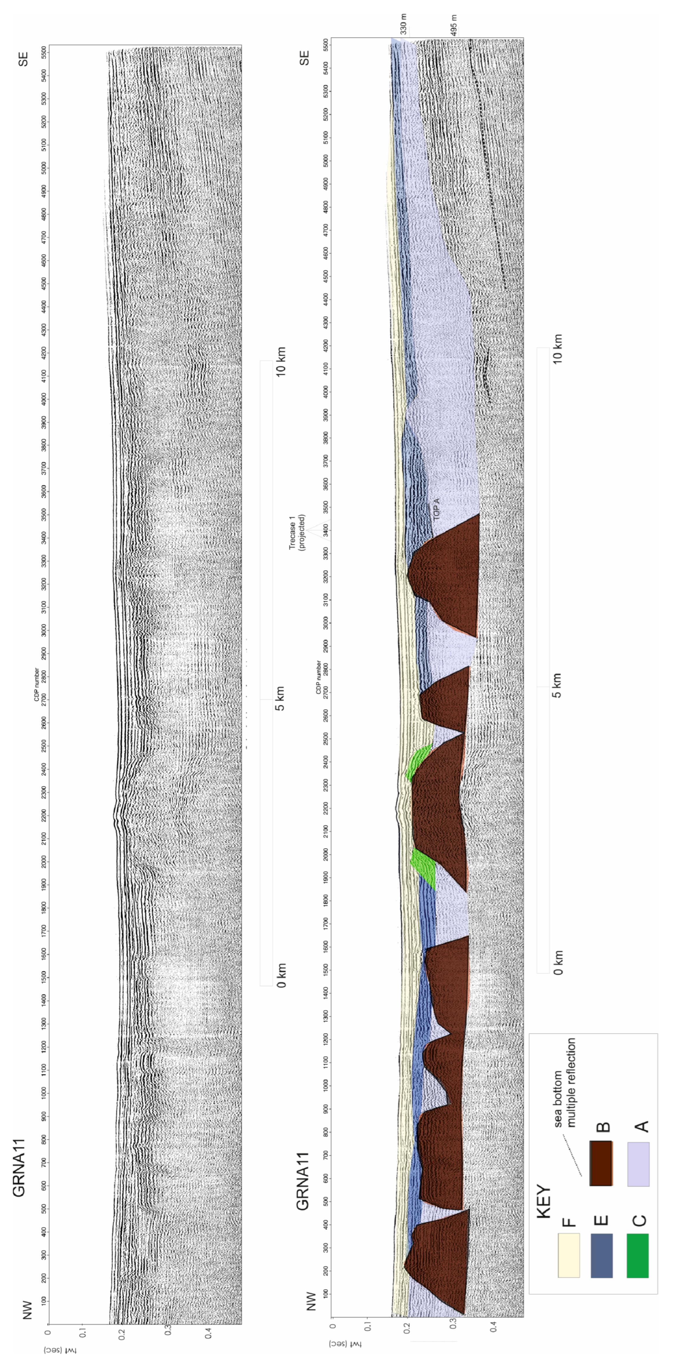
Figure 1. Sketch map showing the location of the seismic profiles superimposed on the Multibeam bathymetric map of Naples Bay. The main morpho-structural features of the Bay of Naples are also reported (Dohrn canyon, Magnaghi canyon, Banco di Fuori). Da1: debris avalanche; BM: Banco della Montagna; NB: Nisida Bank; PP: Pentapalummo Bank; MB: Miseno Bank; IB: Ischia Bank.
Jmse 10 01520 g001
Figure 2. Sketch stratigraphy of the exploration well “Trecase 1” (modified after [36]), integrated with the seismic profiles recorded onshore in the Vesuvius area and calibrated by the Trecase 1 well (modified after [2]). The stratigraphy of the “Palazzo Reale” borehole (modified after [37]) has also been reported.
Jmse 10 01520 g002
Figure 3. Sketch stratigraphy of the deep exploration wells “Villa Literno 2” and “Parete 2” (modified after [42]) showing the Villa Literno and Parete volcanic complexes and correlation of the Villa Literno volcanic complex with the seismic profile Sister4_2 (upper right) and corresponding geologic interpretation (lower right; modified after [40]).
Jmse 10 01520 g003
Figure 4. Geological sections and location of boreholes in the Northern Campania Volcanic Zone (N-CVZ; modified after [52]). Note that the Northern Campania Volcanic Zone (N-CVZ) is the broad area including the portion of the Campania Plain, which is characterized by intense volcanic activity, older than 12 ky B.P. [52]. The stratigraphic data of more than 600 boreholes were analyzed in order to construct the geological sections shown in the figure, showing the stratigraphic relationships between the volcanic units occurring in the subsurface of this sector of the Campania Plain.
Jmse 10 01520 g004
Figure 5. (A) Sketch reconstruction of the original profile of the old Somma volcano (modified after [74]); (B) Sketch diagram showing the eruptive history of the Somma-Vesuvius (calibrated ages; modified after [73]). (C) Geologic map of the Somma-Vesuvius (modified after [75]).
Jmse 10 01520 g005
Figure 6. Seismic profile Grna01 (left side) and seismic profile Grna03 (right side), and corresponding geologic interpretation calibrated with the “Trecase 1” well (Figure 2).
Jmse 10 01520 g006
Figure 7. Seismic profile Grna11 and corresponding geologic interpretation, calibrated with the “Trecase 1” well; (Figure 2).
Jmse 10 01520 g007
Figure 8. Seismic profile Grna15 and corresponding geologic interpretation, calibrated with the “Trecase 1” well (Figure 2).
Jmse 10 01520 g008
Figure 9. Seismic profile Grna17 and corresponding geologic interpretation.
Jmse 10 01520 g009
Figure 10. Seismic profile Grna21 and corresponding geologic interpretation.
Jmse 10 01520 g010
Figure 11. Isopach maps of the “Pomici di Avellino”, “Pompei Pumice”, and “Pomici di Mercato” eruptions (after [25]). These maps were used as geological constraints in order to support the interpretation of the G seismic unit as the PDCs older than the AD 79 eruption. The location of the GRNA01 and GRNA03 seismic profiles (Figure 6) is also shown.
Jmse 10 01520 g011
Figure 12. Sketch showing the geological constraints used for the interpretation of the B seismic unit. On the right side of the figure, several types of volcanic edifices were represented, based on the volcanological literature in order to show the shape and the approximate size of the tuff rings. On the left side of the figure, the GRNA11 and GRNA15 seismic profiles were reported (Figure 7 and Figure 8), showing the interpretation of the volcanic edifices interpreted as tuff rings in the eastern sector of the Bay of Naples. Note that the dimensions of the volcanic edifices, measured on the seismic sections and ranging between 5.6 and 6 km, are compatible with those of the tuff rings recognized in literature in the Neapolitan area [11,72].
Jmse 10 01520 g012
Figure 13. Magnetic map of the eastern Naples Bay and location of the seismic lines with superimposed A, B, and D seismic and volcanic structures based on this paper.
Jmse 10 01520 g013
Table 1. Seismic units of the eastern Bay of Naples.
Seismic ProfilesSeismic UnitsSeismic Facies
External Geometry
GRNA01, GRNA03GUndulated and wavy seismic reflectors, discontinuous.
GRNA11, GRNA15, GRNA17, GRNA21FParallel and continuous seismic reflectors and wedge-shaped external geometry
GRNA11, GRNA15, GRNA21EDiscontinuous and sub-parallel seismic reflectors
GRNA17, GRNA21DAcoustically-transparent seismic facies, wedge-shaped unit
GRNA01, GRNA03, GRNA11, GRNA17, GRNA21CParallel and continuous seismic reflectors. Prograding reflectors onlapping the top of a seismic structure composed of the B unit.
GRNA01, GRNA03, GRNA11, GRNA15, GRNA17, GRNA21BAcoustically-transparent seismic facies and mounded-shaped external geometry
GRNA01, GRNA03, GRNA11, GRNA15, GRNA17, GRNA21AAcoustically transparent seismic facies and tabular external geometry
Publisher’s Note: MDPI stays neutral with regard to jurisdictional claims in published maps and institutional affiliations.

