Article

Environmental Drivers and Spatial Suitability of Erosion Control Measures in the Black Soil Region of Northeast China

1
Cultivated Land Quality & Farmland Engineering Supervision and Protection Center, MARA, Beijing 100125, China
2
Key Laboratory of Ecosystem Network Observation and Modeling, Institute of Geographic Sciences and Natural Resources Research, Chinese Academy of Sciences, Beijing 100101, China
3
University of Chinese Academy of Sciences, Beijing 100049, China
4
Yellow River Delta Modern Agriculture Engineering Laboratory, Institute of Geographic Sciences and Natural Resources Research, Chinese Academy of Sciences, Beijing 100101, China
5
Farmland Construction and Black Soil Protection Service Center of Xing’an League, Ulanhot 137400, China
*
Author to whom correspondence should be addressed.
Agriculture 2026, 16(17), 1908; https://doi.org/10.3390/agriculture16171908
Submission received: 9 July 2026 / Revised: 18 August 2026 / Accepted: 1 September 2026 / Published: 3 September 2026
(This article belongs to the Special Issue Soil Erosion Mechanisms and Water Conservation Processes in Farmland)

Abstract

Sloping farmland erosion in cold-region black soil zones threatens global agriculture, yet regional-scale quantitative evidence on the erosion mitigation performance and spatial suitability of control measures remains lacking. This study integrated 959 field observation datasets from 132 peer-reviewed publications, and used meta-analysis and Boosted Regression Tree (BRT) models to evaluate tillage, biological, engineering, and combined conservation measures in Northeast China. Results showed that all measures significantly reduced erosion, achieving an average runoff reduction of 73.2% and sediment reduction of 83.6%. Specifically, engineering measures showed the highest runoff reduction, while combined measures achieved more than 95% sediment reduction. Machine learning revealed that runoff reduction was primarily regulated by precipitation, whereas sediment reduction was mainly controlled by soil clay content and bulk density. Spatially, tillage, biological, and engineering measures showed the highest suitability in continuous cultivated plains, plain–hill transition zones, and low hilly and gully regions, respectively. This study moves erosion-control assessment beyond comparisons of average runoff and sediment reduction rates toward environmentally matched spatial allocation, providing a basis for targeted black soil conservation and resilient grain production in cold-region agricultural landscapes.

1. Introduction

Black soils are among the world’s most important agricultural resources, widely distributed across the North American Great Plains, the Eurasian black soil belt and parts of South America, and supporting global food production [1]. In this study, the term “black soil region” refers to the major agricultural area of Northeast China in which several soil units recognized under the World Reference Base for Soil Resources (WRB) are distributed, including Haplic Phaeozem, Chernozem, Luvisol, Umbrisol, and Gleyic Phaeozem. They are characterized by high organic matter content, well-developed soil aggregation and strong nutrient-supplying capacity, which sustain highly productive agricultural systems. However, their fertile surface horizons contain abundant organic matter and fine particles that are vulnerable to erosion under intensive cultivation and heavy rainfall. The slow recovery of black soil layers further threatens soil fertility, carbon storage and agricultural sustainability. Increasing land-use pressure and climate change have intensified soil degradation in many black soil regions [2]. Cold-region black soil farmlands worldwide face overlapping risks of soil erosion and climate change. Soil erosion removes topsoil together with nutrients and organic matter, continuously undermining soil productivity and ecosystem stability [3]. Intensified extreme rainfall increases the risk of water erosion, while regional aridification may aggravate wind erosion in some subareas [4]. Halting land degradation has been incorporated into the United Nations 2030 Sustainable Development Goals (SDGs) [5,6].
This global challenge is particularly prominent in the Northeast China black soil region. Covering approximately 1.09 million km2, this region contributes 20.9% of China’s total grain output and serves as a key pillar of national food security [7,8]. Nevertheless, long-term reclamation, cultivation on sloping farmland, and intensive rainfall have triggered severe soil and water loss, with eroded sloping farmlands accounting for 46.4% of the total degraded land in the black soil zone [9]. Persistent erosion has thinned the black soil layer from 60–80 cm in the 1950s to merely 20–40 cm at present, representing a 40–50% average thickness loss [10], which substantially impairs soil water and nutrient retention capacity and farming stability [11]. Therefore, erosion control in Northeast China’s black soil areas not only safeguards domestic black soil resources and stable grain supply, but also provides useful evidence for cold-region black soil protection worldwide.
Three primary categories of soil and water conservation measures—tillage, biological and engineering practices—have been widely tested for runoff and sediment reduction in field trials [12]. Conservation tillage (e.g., no-till and straw mulching) reduces soil loss by 80–90% yet only reduces surface runoff by 10–50%, exhibiting a typical pattern of “strong sediment control, weak runoff mitigation” [13,14,15]. Among engineering measures, terraces reduce slope runoff by 50–90% and sediment yield by 30–90% [16]; contour trenches and drainage systems shorten slope length and disperse concentrated flow to substantially mitigate erosion [17]. Biological measures rely on vegetation coverage, root reinforcement and surface flow retardation to weaken raindrop splash, enhance infiltration and trap sediment, thereby lowering slope erosion intensity [18]. Existing studies mostly rely on single slope plots, small watersheds or isolated measure types, making it difficult to uniformly compare runoff and sediment reduction efficiencies across all conservation practices at a consistent regional scale. Moreover, most prior research interprets benefit disparities through individual factors, such as slope gradient, rainfall, or soil properties, while integrated analyses under coupled climate–topography–soil frameworks remain limited. This restricts mechanistic understanding of environmental matching for erosion control practices.
Meta-analysis and machine learning offer novel effective pathways for regional comprehensive assessment and spatial extrapolation. Meta-analysis integrates multi-region, multi-scale field trial outcomes to enable a unified quantitative comparison of runoff and sediment reduction benefits across diverse measures, improving statistical robustness and regional representativeness. Cross-regional data synthesis has shown that engineering practices achieve sediment reduction above 80%, while biological measures deliver average runoff mitigation over 60%, values that are higher than many results from isolated plot experiments [19,20]. Machine learning quantifies the nonlinear interactions and relative contributions of multi-environmental factors, helping to clarify the integrated regulation of climate, topography and soil on erosion control efficiency, and supporting spatial extrapolation of conservation effects. Despite these advances, the Northeast black soil region still lacks unified data-driven regional comprehensive assessments, especially regarding differentiated runoff-sediment responses, multi-factor driving mechanisms and spatial suitability zoning of conservation measures.
Against this backdrop, this study targets sloping farmlands in Northeast China’s black soil zone, integrates paired field trial datasets, and combines meta-analysis with Boosted Regression Tree (BRT) models to systematically quantify the runoff and sediment reduction benefits of diverse soil conservation practices, reveal environmental factor-driven regulatory mechanisms, and map the spatial potential and suitability patterns of erosion control measures. Three core research questions are addressed: (1) how to quantify runoff and sediment reduction efficiencies of distinct erosion control practices and identify inter-type disparities; (2) how to uncover the regulatory mechanisms of the topographic, climatic and edaphic factors governing erosion mitigation performance; (3) how to characterize the spatial suitability distribution of erosion control efficiency and propose zonal optimized allocation strategies. This study advances sloping Phaeozem erosion research by integrating multi-source evidence, machine learning and spatial analysis to move beyond an isolated evaluation of conservation practices toward a process-based and environment-adaptive assessment framework. The findings provide quantitative insights into the mechanisms underlying runoff–sediment responses and support the targeted allocation of conservation measures in Northeast China’s Phaeozem region, offering a transferable framework for erosion control in cold-region agricultural landscapes.

2. Materials and Methods

2.1. Literature Retrieval, Screening and Database Construction

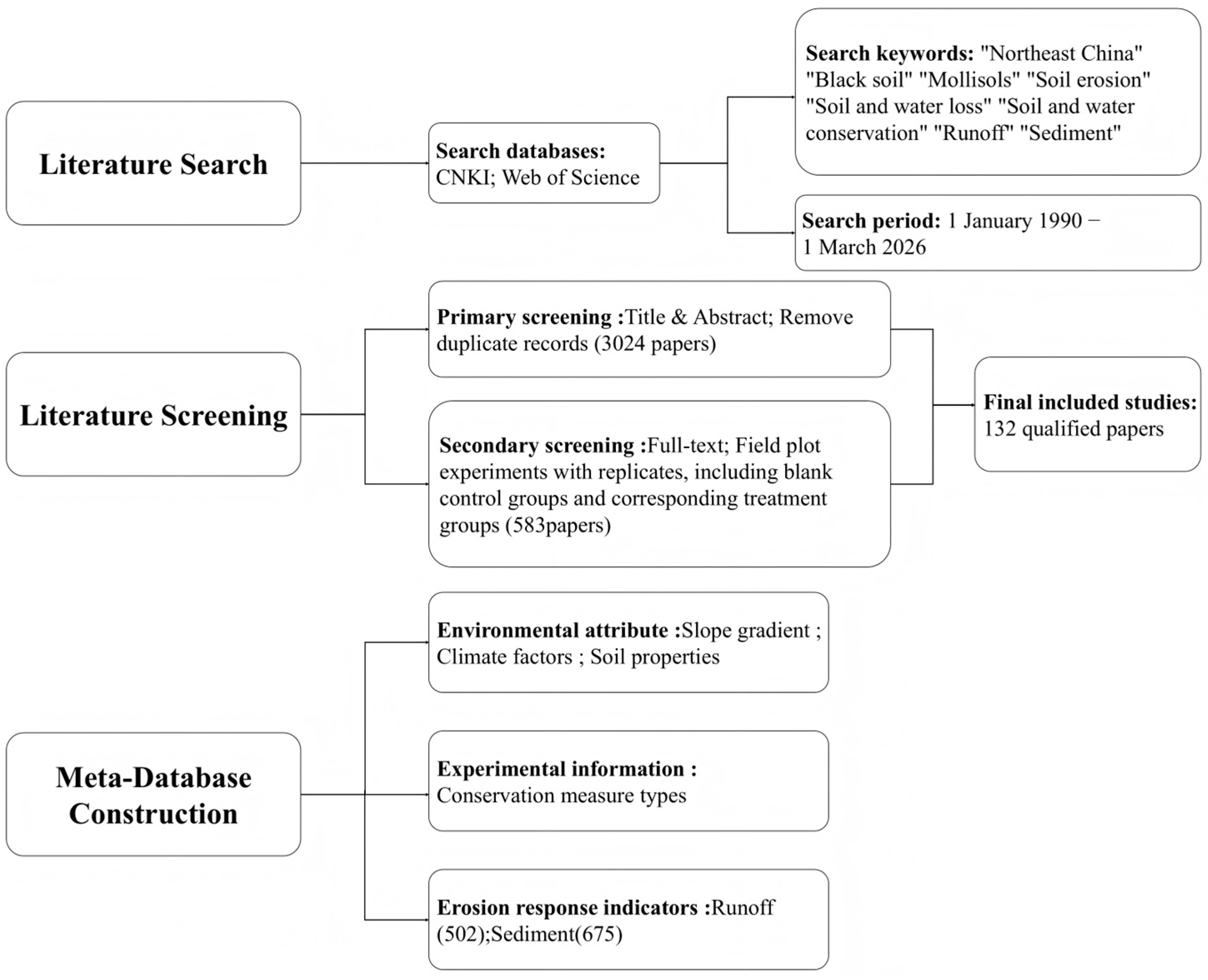
This study systematically retrieved academic publications related to soil erosion and erosion control measures in Northeast China’s black soil region that were published between 1 January 1990 and 1 March 2026 from Chinese and English databases, including China National Knowledge Infrastructure (CNKI) and Web of Science (Figure 1). Search keywords included soil erosion, soil and water conservation, runoff, ridge plant, no tillage, black soil/Mollisols, etc. The GetData2.25 software was applied to extract numerical data from scatter, line and bar charts.
Strict screening criteria were implemented to ensure the quality of the meta-analysis database:
  • Studies were conducted within Northeast China;
  • The studies were replicated field trials;
  • The experimental design included control groups (no erosion control measures) and treatment groups (with conservation practices), with explicit documentation of management protocols for each measure;
  • There was consistent agronomic management (irrigation, fertilization, pest and weed control) between control and treatment groups except for erosion control practices;
  • Independent research outcomes were provided, with no duplicated datasets across publications.
After screening, 132 studies were included, of which 93 were published in Chinese. These studies yielded 959 independent treatment–control comparisons, including 675 comparisons for soil erosion modulus and 502 comparisons for runoff depth, with some comparisons reporting both response variables. Each dataset recorded: (a) geographic coordinates of experimental plots; (b) regional environmental characteristics (annual precipitation, mean temperature, etc.); (c) category of erosion control measures; (d) runoff depth and soil erosion modulus.

2.2. Classification of Erosion Control Measures and Response Variables

Erosion control measures were categorized into three major types: tillage, biological and engineering measures. Tillage practices contained four subcategories with 11 specific treatments; biological practices contained three subcategories with 7 specific treatments; engineering practices contained four subcategories with 8 specific treatments, totaling 26 detailed erosion control techniques (Table 1). Additionally, cross measures were considered as a separate category, including tillage + engineering measures and tillage + biological measures.
Response variables included runoff depth and soil erosion modulus, quantifying surface runoff reduction and soil erosion mitigation efficiency of conservation measures, respectively.

2.3. Meta-Analysis Methodology

Before conducting the meta-analysis, heterogeneity among effect sizes was assessed using Cochran’s Q test and quantified using the I2 statistic. Significant heterogeneity was observed among studies (sediment reduction: p < 0.001, I2 = 99%, τ2 = 12.01; runoff reduction: p < 0.001, I2 = 99%, τ2 = 4.43) [21]. A random-effects model was adopted to integrate effect sizes to accommodate heterogeneity across multi-source field trials differing in environment, landform and experimental duration [22]. The log response ratio (RR) is widely used as the primary effect size metric in experimental meta-analyses in agronomy and soil science. In this study, RR was used as the effect size metric to quantify the runoff and sediment reduction efficiency of erosion control measures. RR < 0 indicates a reduction in runoff or sediment yield relative to the control, RR = 0 indicates no treatment effect, and RR > 0 indicates an increase in the measured variable [23].
R R = l n ( X t X c ) = l n X t l n X c
V = S D t 2 n t X t 2 + S D c 2 n c X c 2
Xt represents the mean values of runoff depth and erosion modulus in the treatment group subjected to erosion control measures; Xc denotes the average value in the control group; SDt and SDc are the standard deviations for the treatment group and the control group, respectively; nt and nc represent the number of experimental replicates for the treatment group and the control group, respectively.
W i = 1 V i + τ 2
R R + + = i = 1 k W i R R i i = 1 k W i
S = 1 i = 1 k W i
95 %   CI = R R + +   ±   1.96 S
RR++ represents the weighted average of overall benefits; Wi denotes the weight of the i-th study case, which incorporates both within-study variance and between-study variance 2) under the random-effects model. S represents the standard error of the pooled effect size; and k denotes the number of study cases included in the meta-analysis. A 95% confidence interval excluding zero indicates a significant effect of conservation measures. Negative and positive confidence intervals indicate significant reductions and increases in the evaluated indicators, respectively.
To facilitate result interpretation and intuitive comparison, RR++ is converted to a percentage of erosion reduction:
RE(%): (1 − exp(RR++)) × 100%

2.4. Environmental Regulators and Subgroup Analysis

Topographic factors (slope gradient, slope length), climatic factors (temperature, precipitation) and soil physicochemical properties potentially modulate erosion control efficiency. Spatial environmental datasets were extracted based on the geographic coordinates of each experimental site to supplement the meta database, and samples were grouped by environmental conditions to quantify efficiency disparities across heterogeneous environments (Table 2).

2.5. BRT Model and Spatial Prediction

Boosted Regression Tree (BRT) is an ensemble machine learning algorithm capable of capturing the complex nonlinear relationships and interactions between variables, with robust fitting and predictive performance, making it ideal for simulating multi-factor driven eco-hydrological processes [24,25]. Model construction and spatial computation were implemented via the gbm and terra packages in R (version 4.6.1). Model performance was evaluated via out-of-bag residuals, with R2, RMSE and MAE adopted as integrated fitting and prediction accuracy metrics to ensure reliability. The percentage erosion reduction efficiency derived from meta-analysis was set as the response variable. Eight environmental factors were selected as explanatory variables based on the existing literature: slope length–gradient factor (LS), soil bulk density (BD), soil pH (pH), soil organic carbon (SOC), total nitrogen (TN), clay content (Cly), mean annual precipitation (MAP) and mean annual temperature (MAT) [23,26,27].
Relative importance index Ij quantifies the explanatory contribution of each driving factor to erosion mitigation efficiency:
I j = t = 1 n t r e e L j , t j = 1 p t = 1 n t r e e L j , t × 100 %
Ij represents the relative importance L j , t n t r e e (%) of the j-th independent variable; L j , t denotes the decrease in the loss function resulting from node splitting at factor j in tree t; p is the total number of independent variables; and n t r e e is the total number of decision trees.
Building on this foundation, separate BRT models were developed for tillage, biological, and engineering measures using the same eight environmental predictors. The trained models were then applied to generate spatial predictions of erosion reduction effectiveness for each measure type.
R E ^ = R E ¯ + t = 1 n t r e e ρ × h t ( X )
R E ^ is the spatial predicted value of the erosion reduction effect; R E ¯ is the global mean of the erosion reduction effect in the training dataset; ρ is the learning rate, set to 0.01 in this study; and h t ( X ) is the residual fitting value output by the t-th regression decision tree based on input factor X.
Finally, an optimal measure selection rule was established based on the three independent BRT predictions to identify spatially suitable conservation measures. The predicted effects of tillage, biological, and engineering measures ( R E ^ t i l , R E ^ b i o , R E ^ e n g ) were compared for each grid cell.
M o p t T i l l a g e   m e a s u r e s ,   R E ^ t i l = m a x ( R E ^ t i l , R E ^ b i o , R E ^ e n g ) B i o l o g i c a l   m e a s u r e s ,   R E ^ b i o = m a x ( R E ^ t i l , R E ^ b i o , R E ^ e n g ) E n g i n e e r i n g   m e a s u r e s ,   R E ^ e n g = m a x ( R E ^ t i l , R E ^ b i o , R E ^ e n g )
R E ^ t i l , R E ^ b i o , R E ^ e n g : Spatial predicted values of erosion reduction effects from tillage, biological, and engineering measures, respectively.

3. Results

3.1. Disparities in Runoff and Sediment Reduction Efficiency Across Erosion Control Measures

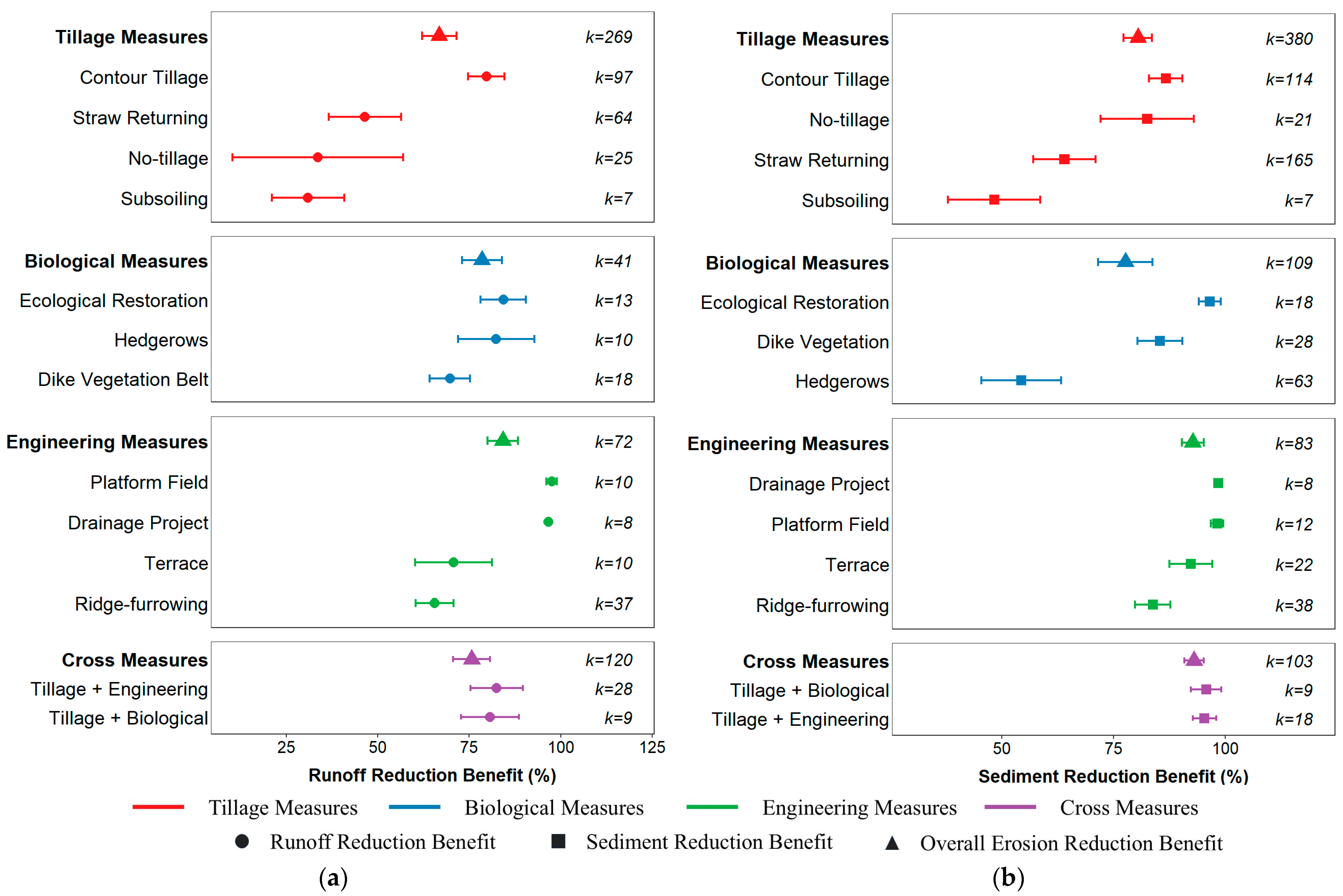
All erosion control practices exhibited significant erosion mitigation effects in the Northeast black soil region, with an overall average runoff reduction of 73.20% and sediment reduction of 83.60%, yet distinct disparities existed across measure types and combined treatments (Figure 2). For single measures, runoff reduction efficiency followed the gradient engineering measures > biological measures > tillage measures. Engineering practices delivered the highest runoff reduction at 84.12%, with drainage systems achieving the optimal performance of 96.70%. Biological measures reduced runoff by 78.35% on average, with natural vegetation restoration and vegetative hedgerows reaching 84.28% and 82.27%, respectively. Tillage practices exhibited relatively weak runoff control at 66.71%. Sediment reduction efficiency followed an identical ranking pattern to runoff mitigation. Engineering practices delivered the strongest sediment control, with drainage systems, platform terraces, and level terraces achieving 98.42%, 96.87% and 92.27% sediment reduction, respectively. Biological measures averaged 85.80% sediment reduction, with natural vegetation restoration reaching 94.00%. Tillage practices reduced sediment by 80.41% on average, among which contour tillage showed the highest efficiency (86.40%), while subsoiling and straw mulching showed relatively weaker effects. Combined measures improved erosion control efficiency: tillage–biological combinations reduced runoff by 80.64% and sediment by 95.71%; tillage–engineering combinations reduced runoff by 82.47% and sediment by 95.36%. These results indicate that single tillage practices possess limited capacity to regulate slope runoff, yet coupling with biological or engineering measures can substantially enhance sediment interception and overall slope erosion mitigation.

3.2. Regulatory Effects of Climate–Topography–Soil Factors on Erosion Mitigation Efficiency

BRT models were constructed to quantify the relative contribution of environmental factors to runoff and sediment reduction efficiency, identifying dominant drivers of erosion control performance. Model fitting statistics indicated moderate to explanatory capacity for erosion mitigation efficiency (Table 3). The coefficient of determination (R2) represents the proportion of the variance in observed values explained by the model, with higher values indicating stronger predictive ability. The root mean square error (RMSE) and mean absolute error (MAE) quantify the deviation between predicted and observed values, with lower values indicating better model accuracy [28].
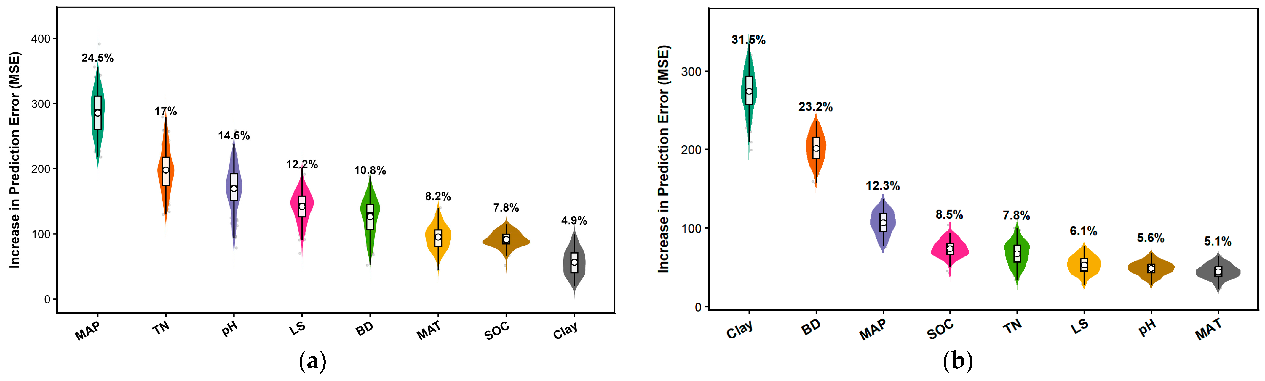
Variable importance ranking from BRT outputs revealed different dominant drivers for runoff versus sediment reduction (Figure 3). Runoff mitigation was primarily controlled by climatic and topographic factors: mean annual precipitation (MAP) ranked first with a contribution rate of 24.5%, indicating that spatial precipitation gradients strongly influence baseline slope runoff generation and the runoff reduction potential of conservation measures. Total nitrogen (TN) and soil pH contributed 17% and 14.6%, respectively, showing edaphic conditions to be secondary regulators of runoff control efficiency. Soil bulk density (BD), mean annual temperature (MAT), soil organic carbon (SOC) and clay content (Clay) each contributed less than 12%, exerting weaker regulatory effects. In contrast, sediment reduction efficiency was predominantly governed by soil physicochemical properties. Soil clay content represented the top driver with a contribution rate of 31.5%, followed by soil bulk density at 23.2%. Together, these two edaphic factors accounted for 54.7% of the total relative importance in the sediment reduction model, suggesting that soil particle cohesion and compaction status are key factors influencing sediment interception capacity. The remaining factors exhibited limited relative importance for sediment control: MAP (12.3%), SOC (8.5%), total nitrogen (TN, 7.8%), LS (6.1%), soil pH (5.6%) and MAT (5.1%).
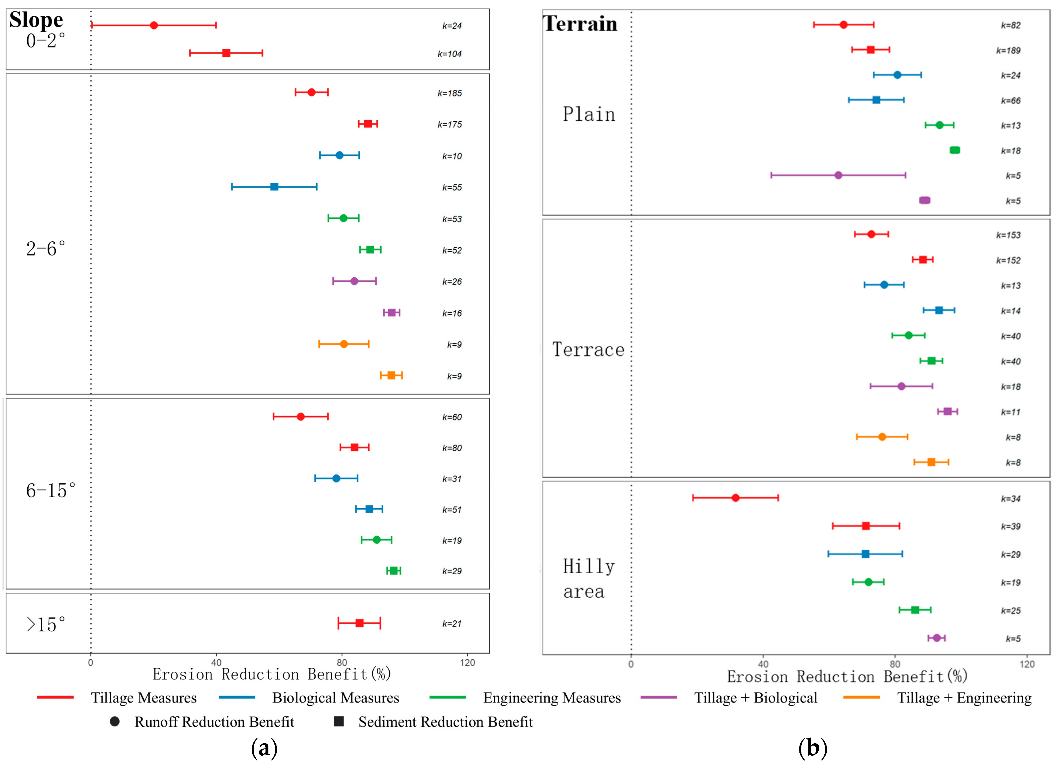
Topography further modulated conservation measure performance (Figure 4). Engineering measures showed the highest efficiency on slopes of 6–15°, reducing runoff by 91.00% and sediment by 96.50%. Tillage practices performed best on gentle slopes of 2–6°, achieving 88.26% sediment reduction. Biological measures maintained stable runoff reduction above 78% across all slope gradients. Combined measures exhibited prominent synergistic effects on 2–6° gentle slopes, with sediment reduction exceeding 95%. From a geomorphic perspective, engineering measures performed optimally in plain regions (runoff reduction: 93.50%, sediment reduction: 98.10%). On terrace, biological and tillage measures achieved high sediment reduction (93.30% and 88.40%, respectively), with stable runoff mitigation above 70%. Combined tillage–engineering measures dominated hilly regions, delivering sediment reduction as high as 98.90%. Overall, engineering measures exhibited superior performance in plains and medium-gradient slopes; tillage and biological practices were more suitable for terrace and gentle slopes; combined multi-type measures provided synergistic erosion control benefits in hilly and complex terrain.
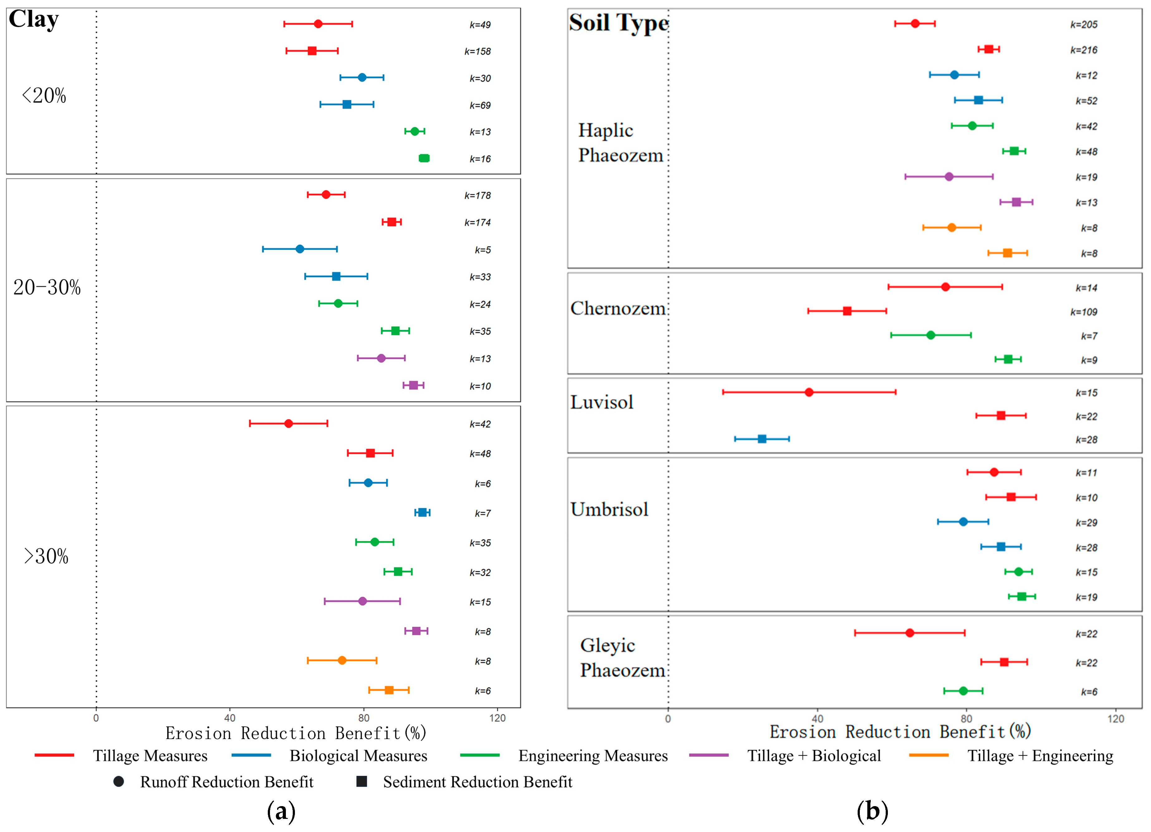
Soil texture and soil type significantly regulated the measure performance (Figure 5). Engineering measures achieved the highest sediment reduction (98.12%) when soil clay content was <20%. All conservation practices declined in efficiency under a clay content of 20–30%, with engineering and biological sediment reduction dropping to 89.50% and 60.97%, respectively. When clay content >30%, biological measures achieved sediment reduction of 97.56%. Combined treatments maintained stable performance across texture gradients: tillage–engineering combinations reduced sediment by 94.91% (20–30% clay) and 95.79% (>30% clay). Across soil types, engineering and tillage practices showed the highest effectiveness on Luvisols, with runoff/sediment reduction reaching 93.90%/94.80% and 87.30%/91.90%, respectively. All conservation measures were substantially weakened on Luvisols: biological sediment reduction fell to merely 25.20%; tillage runoff reduction dropped to 37.70%. Tillage–engineering combinations delivered the highest sediment reduction (98.90%) on Gleyic Phaeozems, maintaining consistent synergistic advantages. Collectively, low-clay soils were more favorable for engineering measures, whereas high-clay environments enhanced the sediment-retention function of biological vegetation. Phaeozems and Luvisols with high organic matter support robust performance of all conservation types; combined multi-measure treatments deliver stable synergistic erosion control under complex edaphic conditions.
The above results confirm that erosion control efficiency is not an inherent fixed attribute of conservation practices, but co-regulated by coupled climate, topographic and edaphic conditions. Sloping black soil governance cannot rely solely on average measure efficiency for regional deployment; instead, runoff regulation and sediment interception pathways should be separately optimized according to spatial gradients of dominant environmental drivers.

3.3. Spatial Pattern of Erosion Mitigation Potential and Zonal Suitability of Conservation Measures

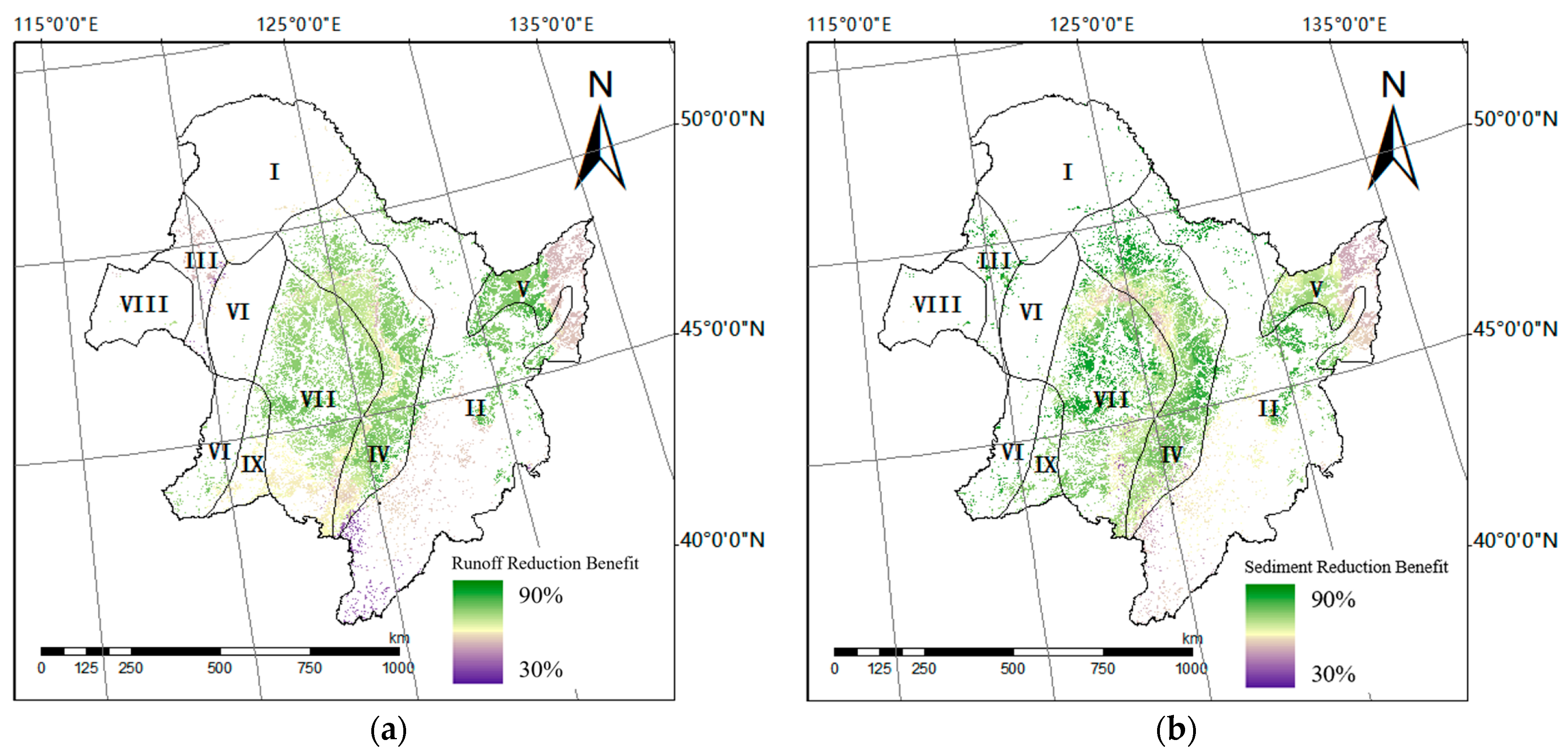
Spatial prediction outputs from the BRT model revealed marked spatial heterogeneity of runoff reduction efficiency across the study region, ranging from 30% to 90% (Figure 6). The central Songliao Plain exhibited the highest average runoff reduction potential at 67.80% (Table 4). Secondary high-efficiency zones included eastern piedmont plains (67.63%), southern Greater Khingan Range (66.04%), eastern Inner Mongolia high plain (65.21%), eastern mountainous areas (64.91%), Sanjiang Plain (64.67%) and southwestern Songliao Plain (63.94%). The Greater Khingan Range and piedmont hilly zones of the San River Basin delivered relatively weak runoff reduction (<60%). Overall, runoff reduction efficiency followed a spatial gradient of high values in central plains and low values in peripheral mountain–hilly zones, indicating that gentle, continuously cultivated flatlands were more favorable for runoff mitigation by conservation measures.
Sediment reduction efficiency also exhibited significant spatial differentiation, ranging from 30% to 90%. The Greater Khingan Range recorded the highest sediment reduction potential at 80.72%. Secondary high-efficiency zones included San River piedmont hills (78.79%), eastern Inner Mongolia high plain (77.74%), southern Greater Khingan Range (76.87%) and southwestern Songliao Plain (72.91%). Eastern piedmont plains, central Songliao Plain, eastern mountainous areas and Sanjiang Plain delivered sediment reduction below 75%. Sediment reduction efficiency followed a northwest–high, southeast–low spatial gradient, suggesting that undulating terrain with strong erosion dynamics may have greater potential for sediment interception by conservation practices.
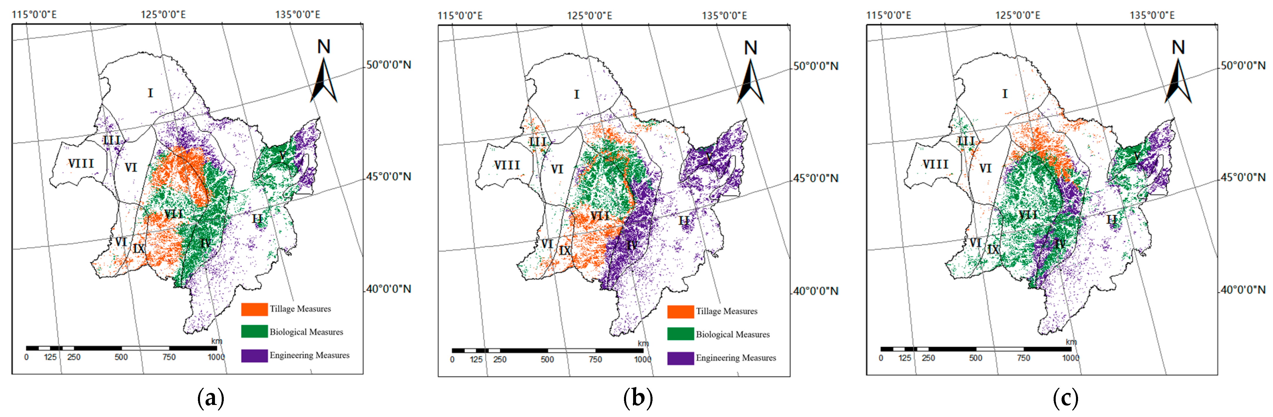
Distinct spatial suitability patterns emerged for tillage, biological and engineering measures when evaluated by runoff reduction, sediment reduction and integrated erosion mitigation performance (Figure 7). From a runoff reduction perspective, tillage measures were primarily suitable for large-scale continuous cultivated zones in northern and southwestern Songliao Plain; biological measures matched the western Sanjiang Plain and east Songliao plain–hill transition belts; engineering measures were optimal for low hilly and gully-intensive zones in southern and northeastern Greater Khingan Range. For sediment reduction, tillage suitability concentrated in the southwestern Songliao Plain; biological measures exhibited amplified suitability in southern Greater Khingan Range; engineering measures delivered high matching performance in east Songliao hilly transition zones.
Integrating runoff control, sediment interception, and regional environmental conditions, a differentiated spatial allocation of erosion control practices is proposed for sloping farmlands in the Northeast black soil region. Eastern piedmont plains prioritize tillage practices, including no-till and straw mulching, to strengthen surface soil protection and structural stability. Eastern mountainous and hilly zones adopt engineering measures such as terraces and drainage systems to dissipate slope runoff energy and reduce sediment transport intensity. Central Songliao Plain and partial plain–hill transition belts deploy biological measures including vegetative hedgerows and contour vegetation strips to enhance surface flow retardation and sediment trapping capacity.

4. Discussion

4.1. Disparities in Runoff-Sediment Reduction Efficiency and Underlying Process Mechanisms

Distinct erosion control practices regulate slope runoff generation, soil particle detachment and sediment through different divergent hydrological pathways, generating prominent differentiation between runoff and sediment reduction efficiency. Engineering measures reshape micro-topography, shorten effective slope length and reduce slope hydraulic energy gradients, thereby showing consistently high erosion mitigation performance. Terraces dissipate flow energy via slope grading, runoff impoundment and flow dispersion, achieving a sediment reduction above 90% over medium–long-term monitoring (6–15 years) [29,30,31,32,33,34]. Contour half-moon trenches shorten runoff flow paths through micro-topographic water storage [32,35,36,37], delivering a runoff reduction of 36.93% [18]. Direct structural modification of slope surfaces enables consistent, stable runoff and sediment control for engineering practices.
In contrast, isolated biological and tillage practices rely primarily on surface vegetation coverage and near-surface soil structural improvements, with erosion mitigation performance highly sensitive to rainfall intensity, slope gradient and edaphic conditions. Biological measures reduce runoff via canopy interception, litter water retention and root-enhanced infiltration; field trials confirm vegetative hedgerows deliver runoff reduction of 57% [29]. Tillage practices increase surface roughness, optimize near-surface soil structure and alter micro-topography to mitigate erosion; combined no-till and straw mulching reduce runoff by 32.8–56.4% and sediment yield by 56.4–97.9% [18]. However, single tillage practices exert limited modification on slope runoff pathways and concentrated flow energy, leading to weakened runoff control under intense rainfall or steep slope gradients. Combined multi-type measures generate prominent synergistic effects: contour tillage paired with vegetative hedgerows achieves a sediment reduction above 90%, substantially outperforming isolated no-till, straw mulching, or contour ridge planting [38]. Such synergy arises from functional complementarity across practice categories: tillage enhances surface coverage and infiltration capacity, biological vegetation retards flow velocity and traps sediment, and engineering structures dissipate bulk hydraulic energy. Integrated multi-process regulation compensates the functional deficiencies of isolated practices and stabilizes erosion mitigation performance.
Across all conservation types, sediment reduction efficiency consistently exceeds runoff reduction efficiency, confirming stronger suppression of soil particle detachment and transport than surface runoff generation. A national-scale meta-analysis also reported an average runoff reduction of 36.09% and sediment reduction of 51.69% for low-disturbance tillage practices [38]. This divergence indicates asynchronous responses of runoff yield and sediment transport to conservation measures. Runoff regulation depends primarily on slope water balance, infiltration capacity and concentrated flow pathways, while sediment control is governed by soil particle dispersion, surface scouring, sediment deposition and flow connectivity. Therefore, sloping black soil erosion governance should not evaluate conservation performance solely by a single erosion reduction metric, but differentiate runoff source control and sediment interception processes to construct integrated multi-measure management frameworks.

4.2. Regulatory Mechanisms of Climate, Topography and Soil on Erosion Control Efficiency

The BRT analysis showed that climate, topographic and soil factors jointly regulated erosion mitigation efficiency. The R2 values for runoff and sediment reduction efficiency were 0.45 and 0.59, respectively (Table 3). The models showed moderate explanatory capacity, accounting for 45% and 59% of the observed variation in runoff and sediment reduction, respectively [39]. The higher explanatory power for sediment reduction suggests that sediment control was more strongly associated with environmental factors such as slope, topography, soil properties, and vegetation coverage [40]. In contrast, runoff reduction was influenced by short-term processes, including rainfall-event characteristics, antecedent soil moisture, and infiltration dynamics, which were not consistently available in the meta-analysis dataset. Additional unexplained variation may also arise from differences in management history, experimental duration, and seasonal vegetation dynamics among studies [41].
Erosion mitigation efficiency emerges from coupled interactions of climate, topographic and edaphic conditions. This study verified that runoff reduction is primarily climate-regulated, with mean annual precipitation as the dominant driver. Total rainfall and rainfall intensity establish baseline slope runoff yield, and simultaneously constrain the water storage capacity and structural stability of conservation measures. Conservation practices deliver runoff and sediment reductions of 81.48% and 94.12% in arid zones (MAP < 500 mm), versus 64.55% under moderate precipitation (1000–1500 mm); runoff mitigation efficiency declines to 46.28% in hyper-humid zones (MAP > 1500 mm) [34]. Summer concentrated heavy rainfall characterizes the Northeast black soil region [42], and runoff reduction efficiency of conservation measures declines with rising precipitation volume [43,44,45,46]. Intense raindrop splash disrupts topsoil aggregate stability, while prolonged rainfall continuously replenishes slope runoff [47], saturating storage structures and attenuating runoff regulation capacity [48,49,50,51,52].
Unlike runoff generation processes, sediment reduction is predominantly governed by soil physicochemical properties, with clay content exerting the strongest regulatory effect. Phaeozems and Luvisols contain elevated clay and organic matter, strengthening inter-particle cementation and water-stable aggregate formation, and improving soil structural stability, infiltration capacity and inherent anti-erodibility [53]. Robust soil structures provide favorable edaphic foundations for conservation practices to exert water storage and sediment trapping functions. Prior research validated soil texture as the dominant driver of soil nutrient loss variability, explaining 32.41% of total variance (p < 0.01). Tillage sediment reduction efficiency varies drastically across soil texture gradients: loam soils (70–75%) > sandy soils (65–70%) > clay soils (40–55%) [27].
Slope gradient further modulates conservation performance. Steeper slopes accelerate flow velocity and shear stress, amplifying surface scouring and potentially breaking continuity of ridge bunds, vegetative barriers and small impoundment structures. Field trials in Northeast black soil zones confirmed contour ridge planting delivers runoff and sediment reductions of above 93% on representative 7° slopes; the optimal efficiency range spans 3–10° (runoff reduction ≥ 75%; sediment reduction ≥ 82%). Efficiency declines sharply on slopes of 10–15°, and falls below 40% for gradients ≥20° due to ridge cutting and structural collapse under concentrated flow [51]. On gentle slopes, low hydraulic energy enables tillage practices to mitigate erosion via ridge orientation adjustment, increased surface roughness and enhanced infiltration. On steep slopes, drastically amplified flow energy renders isolated tillage practices ineffective, necessitating terraces and other engineering structures to fundamentally reduce slope hydraulic gradients [33].
Collectively, runoff generation processes are governed by precipitation and slope hydraulic dynamics, while sediment transport is primarily constrained by soil texture, structural stability and inherent anti-erodibility. Topography acts as an intermediate regulator mediating the capacity of conservation practices to maintain stable runoff control and sediment trapping functions. Future sloping black soil erosion governance in Northeast China must integrate rainfall regime, slope gradient and baseline soil properties into measure allocation frameworks, rather than uniformly promoting conservation practices based solely on average efficiency metrics.

4.3. Spatial Allocation of Sloping Black Soil Erosion Control and Implications for Cold-Region Erosion Governance

Spatial heterogeneity of conservation efficiency across the Northeast black soil region reflects integrated environmental regulation from climate, topography and soil gradients. Therefore, regional governance strategies cannot adopt uniform technical solutions; instead, zonal optimized allocation should be implemented based on dominant environmental drivers and landform differentiation. Low-gradient, continuously cultivated plain zones exhibit low slope hydraulic energy, and tillage improvement practices, including no-till, reduced tillage, and straw mulching, should be prioritized to strengthen surface protection, minimize soil disturbance, and preserve structural stability. Hilly transition zones experience amplified slope hydraulic energy and intensified erosion processes, where biological measures, including vegetative hedgerows, shrub bunds, and contour vegetation strips, should be deployed to construct continuous flow-retardation units and enhance runoff reduction and sediment trapping capacity. Steep slopes and gully-intensive zones feature strong erosion dynamics and high sediment flux, requiring engineering measures as core interventions: terraces, drainage networks and micro-topography reconstruction fundamentally reduce slope hydraulic energy gradients, paired with biological vegetation to improve long-term system stability. Furthermore, prominent synergistic efficiency of combined multi-measure treatments on gentle slopes confirms functional complementarity across conservation categories, enabling efficiency maximization via integrated multi-type deployment. Sloping black soil governance should shift from isolated single-measure optimization to systematic integrated spatial allocation.
From a global perspective, the Northeast China black soil zone shares analogous climatic conditions, seasonal rainfall regimes and sloped cropland utilization patterns with black soil/freeze–thaw-affected cold regions across North America, Europe and Asia. Cold-region black soil protection should transition from isolated single-practice promotion to environmentally adaptive combined measure allocation and long-term adaptive management. The ultimate objective extends beyond short-term soil loss reduction to the sustained preservation of soil structure, agricultural production capacity and long-term grain system resilience.

4.4. Uncertainty and Future Perspectives

Although this study systematically evaluated runoff and sediment reduction efficiencies and the spatial suitability of conservation practices, uncertainties remain regarding their long-term effectiveness. Engineering measures generally provide rapid erosion control by reducing slope hydraulic energy, but their performance may decline due to structural aging, maintenance requirements and extreme rainfall events. In contrast, tillage and biological practices depend on ecological processes such as vegetation recovery and soil improvement, leading to greater variability under different climatic and management conditions. Long-term monitoring is therefore needed to evaluate the stability and temporal dynamics of conservation practices.
The BRT model was used to identify environmental controls on conservation efficiency and capture nonlinear relationships between measures and environmental factors. The resulting measure-specific predictions were then compared under consistent spatial environmental conditions to evaluate the relative suitability of different conservation measures. However, the moderate predictive performance suggests that some spatial variability remains unexplained, likely due to excluded management and dynamic environmental factors. Previous studies showed that conservation effects vary with duration: short-term (≤5 years) measures reduced runoff and sediment by 34% and 62%, respectively, whereas only terracing and no-tillage maintained 77–100% sediment reduction after >15 years [34]. A 30% decline in seasonal vegetation cover can increase sediment export by >80% [54]. Therefore, the suitability maps should be interpreted as decision-support tools rather than definitive recommendations and integrated with field observations and expert knowledge.
Furthermore, this study focused on the biophysical benefits of conservation measures (runoff and sediment reduction) but excluded costs, maintenance, and economic returns. Previous studies show delayed economic benefits: conservation agriculture may reduce yields by 5.1–8.5% in the first 3 years in Europe and temperate regions but improves long-term stability and returns [55]; soil bunds achieve positive returns after 7 years, whereas terraces require 21 years [56]. Engineering measures require higher investments, while tillage, biological, and integrated practices may be more cost-effective. Future assessments should integrate cost–benefit, productivity, and policy factors to balance ecological and economic sustainability.

5. Conclusions

This study systematically quantified runoff and sediment reduction efficiency of diverse erosion control measures and mapped their spatial suitability patterns across Northeast China’s sloping black soil farmlands. All tillage, biological, engineering and combined multi-type measures delivered significant runoff and sediment reduction, with regional average runoff mitigation of 73.2% and sediment mitigation of 83.6%. Engineering practices achieved the highest isolated runoff reduction efficiency at 84.12%. Isolated tillage and biological measures delivered relatively weaker performance, yet tillage paired with biological or engineering treatments generated prominent synergistic effects, with sediment reduction consistently exceeding 95%. BRT modeling revealed divergent dominant drivers for runoff versus sediment reduction: runoff mitigation was primarily regulated by mean annual precipitation (24.5%), TN (17%) and soil pH (14.6%); sediment reduction was dominated by soil clay content (31.5%), bulk density (23.2%) and precipitation (12.3%). Spatial prediction demonstrated the central Songliao Plain possesses the highest runoff reduction potential at 67.80%; the Greater Khingan Range, San River piedmont hills and eastern Inner Mongolia high plain deliver superior sediment reduction potential at 80.72%, 78.79% and 77.74%, respectively. Distinct spatial suitability zoning emerged for conservation categories: continuous cultivated plains of the Eastern Piedmont Plain prioritize tillage measures; plain-hill transition belts and peripheral Sanjiang Plain fit biological vegetation practices; low hilly and gully zones within the Greater Khingan Range are most compatible with engineering structures. Overall, sloping black soil erosion governance in Northeast China should shift from arbitrary single-measure selection to zonal optimized allocation and integrated multi-type conservation deployment constrained by coupled climate–topography–soil conditions, to enhance long-term stability of black soil protection and cold-region grain production systems.
This study has several limitations. First, the meta-analysis was constrained by the available literature data, and some key variables (e.g., rainfall erosivity, management practices, crop rotation and seasonal vegetation dynamics) were not included, limiting the mechanistic interpretation of erosion control processes [54,55]. Second, experimental duration was inconsistently reported among studies, precluding practice-specific assessment of temporal changes or declines in conservation effectiveness. In addition, the BRT model mainly captured the statistical relationships between environmental factors and conservation efficiency, with limited representation of long-term hydrological and soil feedbacks. Future studies should integrate long-term observations, process-based models and multi-source data to improve erosion assessment and develop environment-specific optimization strategies for adaptive and integrated conservation management [34,56].

Author Contributions

Conceptualization, Z.C., Y.X., L.Z. and H.G.; methodology, Y.X. and J.F.; data curation, Y.X. and J.F.; writing—original draft preparation, J.F.; writing—review and editing, Y.X.; visualization, Y.X. and J.F.; supervision, Y.Z. and J.L.; project administration, Y.Z. and J.L. All authors have read and agreed to the published version of the manuscript.

Funding

The study was financially supported by the National Key R&D Program of China (2024YFD1500200).

Data Availability Statement

The data are available from the authors upon reasonable request.

Conflicts of Interest

The authors declare no conflicts of interest.

References

  1. Liao, X.; Li, Y.; Wang, J.; Dong, J.; Yao, Q.; Li, J.; Hou, R.; Li, Z.; Zhang, Y.; Jia, X.; et al. Governing Black Soils for Food and Climate Security. Nat. Commun. 2026, 17, 1488. [Google Scholar] [CrossRef] [Scilit]
  2. Song, C.; Yihyun, C.; Chapman, Z.; Byun, E. Formation and Evolution of Black Soils: A Global Review. Int. Soil Water Conserv. Res. 2026, 100708. [Google Scholar] [CrossRef] [Scilit]
  3. Aneseyee, A.B.; Elias, E.; Soromessa, T.; Feyisa, G.L. Land Use/Land Cover Change Effect on Soil Erosion and Sediment Delivery in the Winike Watershed, Omo Gibe Basin, Ethiopia. Sci. Total Environ. 2020, 728, 138776. [Google Scholar] [CrossRef] [Scilit]
  4. Ma, X.; Zhao, C.; Zhu, J. Aggravated Risk of Soil Erosion with Global Warming—A Global Meta-Analysis. CATENA 2021, 200, 105129. [Google Scholar] [CrossRef] [Scilit]
  5. Duan, X.; Bai, Z.; Rong, L.; Li, Y.; Ding, J.; Tao, Y.; Li, J.; Li, J.; Wang, W. Investigation Method for Regional Soil Erosion Based on the Chinese Soil Loss Equation and High-Resolution Spatial Data: Case Study on the Mountainous Yunnan Province, China. CATENA 2020, 184, 104237. [Google Scholar] [CrossRef] [Scilit]
  6. Madureira, P.; Squires, D.; Ribeiro, L.P. The International Seabed Authority and the United Nations 2030 Agenda for Sustainable Development. Resour. Policy 2023, 86, 104166. [Google Scholar] [CrossRef] [Scilit]
  7. Gao, J.; Liu, L.; Guo, L.; Sun, D.; Liu, W.; Hou, W.; Wu, S. The Effects of Climate Change and Phenological Variation on Agricultural Production and Its Risk Pattern in the Black Soil Area of Northeast China. J. Geogr. Sci. 2023, 33, 37–58. [Google Scholar] [CrossRef] [Scilit]
  8. Ba, Z.; Wang, J.; Song, C.; Du, H. Spatial Heterogeneity of Soil Nutrients in Black Soil Areas of Northeast China. Agron. J. 2022, 114, 2021–2026. [Google Scholar] [CrossRef] [Scilit]
  9. Liu, X.B.; Zhang, X.Y.; Wang, Y.X.; Sui, Y.Y.; Zhang, S.L.; Herbert, S.J.; Ding, G. Soil Degradation: A Problem Threatening the Sustainable Development of Agriculture in Northeast China. Plant Soil Environ. 2010, 56, 87–97. [Google Scholar] [CrossRef] [Scilit]
  10. Huang, B.; Gao, J.; Zhang, W.; Gan, C.; Bao, X.; Xu, M.; Wu, L. Impacts of Conservation Tillage on Soil Organic Carbon and Crop Yield in Black Soil Region of Northeast China: Integrated Regulation by Climate, Management and Soil Properties. J. Agric. Food Res. 2025, 24, 102388. [Google Scholar] [CrossRef] [Scilit]
  11. Mudare, S.; Jing, J.; Makowski, D.; He, X.; Liang, Z.; Sims, Z.; Wanger, T.C.; Tilman, D.; Zhang, F.; Cong, W.-F. Crop Rotations Synergize Yield, Nutrition, and Revenue: A Meta-Analysis. Nat. Commun. 2025, 16, 9552. [Google Scholar] [CrossRef] [Scilit]
  12. Yin, Y.; Li, G.; Xia, Y.; Wu, M.; Huang, M.; Zhai, L.; Fan, X.; Zhou, J.; Kong, X.; Zhang, F.; et al. How to Effectively Reduce Sloping Farmland Nutrient Loss and Soil Erosions in the Three Gorges Reservoir Area. Agric. Water Manag. 2024, 304, 109084. [Google Scholar] [CrossRef] [Scilit]
  13. Yu, H.; Sun, Y.; Cui, Y.; Tan, X.; Hou, Y.; Kuang, Z. The Impact of Farmers’ Cognition and Attitudes on the Adoption of Conservation Tillage: An Empirical Study Based on the Lishu Model. Sustainability 2025, 17, 5649. [Google Scholar] [CrossRef] [Scilit]
  14. Thapa, V.R.; Ghimire, R.; Adhikari, K.P.; Lamichhane, S. Soil Organic Carbon Sequestration Potential of Conservation Agriculture in Arid and Semi-Arid Regions: A Review. J. Arid Environ. 2023, 217, 105028. [Google Scholar] [CrossRef] [Scilit]
  15. Stevenson, J.R.; Serraj, R.; Cassman, K.G. Evaluating Conservation Agriculture for Small-Scale Farmers in Sub-Saharan Africa and South Asia. Agric. Ecosyst. Environ. 2014, 187, 1–10. [Google Scholar] [CrossRef] [Scilit]
  16. Barbosa, E.A.A.; de Paula, A.L.; dos Santos, É.L.; Barbosa, F.T.; Giarola, N.F.B. Use of Agricultural Terraces to Control Water Loss on Slopes Cultivated with Grains Under a No-TillAGE System. Eng. Agríc. 2025, 45, e20240186. [Google Scholar] [CrossRef] [Scilit]
  17. Qian, R.; Gao, L.; Hu, W.; Liu, J.; Du, H.; Peng, X. Conservation Tillage Could Achieve SOC Accumulation of Eroding Farmland in Black Soil Regions. Soil Tillage Res. 2026, 258, 107039. [Google Scholar] [CrossRef] [Scilit]
  18. Qin, W.; Niu, L.; You, Y.; Cui, S.; Chen, C.; Li, Z. Effects of Conservation Tillage and Straw Mulching on Crop Yield, Water Use Efficiency, Carbon Sequestration and Economic Benefits in the Loess Plateau Region of China: A Meta-Analysis. Soil Tillage Res. 2024, 238, 106025. [Google Scholar] [CrossRef] [Scilit]
  19. Chen, D.; Wei, W.; Chen, L. Effects of Terracing Practices on Water Erosion Control in China: A Meta-Analysis. Earth-Sci. Rev. 2017, 173, 109–121. [Google Scholar] [CrossRef] [Scilit]
  20. Mitiku, G.K.; Gathenya, J.; Mati, B.; Addis, H.K. Sediment Hotspot Identification and Evaluation of Best Management Practices under Future Climate in the Beressa Watershed Ethiopia. Environ. Res. Commun. 2026, 8, 055058. [Google Scholar] [CrossRef] [Scilit]
  21. Guan, D.; Gu, H.; Bian, Z.; Wang, C.; Guo, X.; Sun, H. Evaluating the Influence of Deep Tillage Depth and Complementary Technologies on Soil Properties and Maize Yield: Evidence From a Meta-Analysis. Land Degrad. Dev. 2025, 37, 652–669. [Google Scholar] [CrossRef] [Scilit]
  22. Zhang, S.; Song, B. Key Issues to Consider in the Application of Meta-analysis. Biodivers. Sci. 2026, 34, 36–46. [Google Scholar]
  23. Liu, L.; Luo, J.; Yu, R.; Tang, H.; Ma, R.; Zhang, X.; Straffelini, E.; Tarolli, P. Soil Conservation Measures Enhanced Soil Organic Carbon Storage Across China. Land Degrad. Dev. 2025, 36, 5382–5392. [Google Scholar] [CrossRef] [Scilit]
  24. Liu, Q.; Wang, T.; Han, Q.; Sun, S.; Liu, C.; Chen, X. Diagnosing Environmental Controls on Actual Evapotranspiration and Evaporative Fraction in a Water-Limited Region from Northwest China. J. Hydrol. 2019, 578, 124045. [Google Scholar] [CrossRef] [Scilit]
  25. Elith, J.; Leathwick, J.R.; Hastie, T. A Working Guide to Boosted Regression Trees. J. Anim. Ecol. 2008, 77, 802–813. [Google Scholar] [CrossRef] [Scilit]
  26. He, C.; Niu, J.-R.; Xu, C.-T.; Han, S.-W.; Bai, W.; Song, Q.-L.; Dang, Y.P.; Zhang, H.-L. Effect of Conservation Tillage on Crop Yield and Soil Organic Carbon in Northeast China: A Meta-Analysis. Soil Use Manag. 2022, 38, 1146–1161. [Google Scholar] [CrossRef] [Scilit]
  27. Yan, Y.; Li, H.; Zhang, M.; Liu, X.; Zhang, L.; Wang, Y.; Yang, M.; Cai, R. Straw Return or No Tillage? Comprehensive Meta-Analysis Based on Soil Organic Carbon Contents, Carbon Emissions, and Crop Yields in China. Agronomy 2024, 14, 2263. [Google Scholar] [CrossRef] [Scilit]
  28. Jin, Y.; Zhang, X.Y.; Zhang, F.; Zhang, S.H. Meta-analysis of the Effects of Typical Soil and Water Conservation Measures on Runoff and Sediment Reduction on Slopes of the Loess Plateau. Sci. Soil Water Conserv. 2026, 24, 17–30. [Google Scholar]
  29. Xu, X.; Zheng, F.; Wilson, G.V.; He, C.; Lu, J.; Bian, F. Comparison of Runoff and Soil Loss in Different Tillage Systems in the Mollisol Region of Northeast China. Soil Tillage Res. 2018, 177, 1–11. [Google Scholar] [CrossRef] [Scilit]
  30. Silva, T.P.; Bressiani, D.; Ebling, É.D.; Reichert, J.M. Best Management Practices to Reduce Soil Erosion and Change Water Balance Components in Watersheds under Grain and Dairy Production. Int. Soil Water Conserv. Res. 2024, 12, 121–136. [Google Scholar] [CrossRef] [Scilit]
  31. Zhang, J.; Wang, M.; Liu, K.; Zhao, Z. Dynamic Changes in Soil Erosion and Challenges to Grain Productivity in the Black Soil Region of Northeast China. Ecol. Indic. 2025, 171, 113145. [Google Scholar] [CrossRef] [Scilit]
  32. Hultgren, A.; Carleton, T.; Delgado, M.; Gergel, D.R.; Greenstone, M.; Houser, T.; Hsiang, S.; Jina, A.; Kopp, R.E.; Malevich, S.B.; et al. Impacts of Climate Change on Global Agriculture Accounting for Adaptation. Nature 2025, 642, 644–652. [Google Scholar] [CrossRef] [Scilit]
  33. Jiang, F.; Peng, X.; Yao, S.; Islam, M.U.; Zhang, Z.; Chen, B.; Wang, Y.; Wang, N.; Qi, H.; Wang, Z.; et al. A Six-Site Field Study on Assessing the Suitability of Conservation and Conventional Tillage in the Black Soil Region, Northeast China. Soil Tillage Res. 2025, 248, 106379. [Google Scholar] [CrossRef] [Scilit]
  34. Rajbanshi, J.; Das, S.; Paul, R. Quantification of the Effects of Conservation Practices on Surface Runoff and Soil Erosion in Croplands and Their Trade-off: A Meta-Analysis. Sci. Total Environ. 2023, 864, 161015. [Google Scholar] [CrossRef] [Scilit]
  35. Guo, C.; Zhao, Q.; Dai, Y.; Sui, Y.; Zhu, Q. Effect of Surface Drainage System on Water and Nutrient Loss from Sloping Farmland in the Black Soil Region of Northeast China. Environ. Earth Sci. 2025, 84, 304. [Google Scholar] [CrossRef] [Scilit]
  36. Xing, S.; Zhang, G.; Zhang, N.; Zhang, Y.; Zhang, Y. How Straw Return Approaches Affect Runoff and Sediment in Croplands of Different Degradation Degrees in the Black Soil Region of China. J. Hydrol. 2025, 653, 132786. [Google Scholar] [CrossRef] [Scilit]
  37. Sui, Y.; Ou, Y.; Yan, B.; Xu, X.; Rousseau, A.N.; Zhang, Y. Assessment of Micro-Basin Tillage as a Soil and Water Conservation Practice in the Black Soil Region of Northeast China. PLoS ONE 2016, 11, e0152313. [Google Scholar] [CrossRef] [Scilit]
  38. Jia, L.; Zhao, W.; Fu, B.; Daryanto, S.; Wang, S.; Liu, Y.; Zhai, R. Effects of Minimum Soil Disturbance Practices on Controlling Water Erosion in China’s Slope Farmland: A Meta-Analysis. Land Degrad. Dev. 2019, 30, 706–716. [Google Scholar] [CrossRef] [Scilit]
  39. Xu, J.; Duan, B.; Wang, Y.; Liu, X.; He, W.; Gao, W.; Chen, Y.; Cui, J. Suitability Assessment of Film Mulching on Maize Production in Northwest China: Integrating Meta-Analysis with Machine Learning. Field Crops Res. 2025, 328, 109919. [Google Scholar] [CrossRef] [Scilit]
  40. Zhao, Y.; Tian, Z.; Ma, R.; Qu, L.; Wu, Y.; Liang, Y. Impact of Soil Erosion-Driven Degradation on Crop Yield in Black Soils of Northeast China’s Songnen Plain. Pedosphere 2025, 35. [Google Scholar] [CrossRef] [Scilit]
  41. Wang, Z.; Yang, X.; Cai, H. Analysis of Influencing Factors of Soil Erosion Changes Based on Structural Equation Model. Land 2025, 14, 304. [Google Scholar] [CrossRef] [Scilit]
  42. Song, Y.; He, X.; Fu, J.; Zheng, F.; Li, Z. Crop Yield–Soil Quality Trade-Offs under No-Tillage and Deep Tillage in the Black Soil Region of Northeast China. Field Crops Res. 2026, 339, 110337. [Google Scholar] [CrossRef] [Scilit]
  43. Huai, R.; Meng, L.; Cheng, T.; Xie, Y.; Ma, Y.; Shi, Z.; Wu, G.-L. Contribution of Herbaceous Energy Crops in Maintaining Runoff and Reducing Soil Loss on the Loess Slopes under Natural Rainfall in the Semi-Arid Area. CATENA 2026, 263, 109737. [Google Scholar] [CrossRef] [Scilit]
  44. Peng, J.; Geng, T.; Wang, Q.; Zhang, C.; Wang, J.; Cai, C. Responses of Soil Pore Structure and Erosion Resistance to Long-Term Cultivation in the Mollisol Region of Northeast China. CATENA 2025, 261, 109520. [Google Scholar] [CrossRef] [Scilit]
  45. Liu, Z.; Wang, M.; Liu, X.; Lyu, X.; Wang, M.; Wang, F.; Ji, X.; Li, X. Spatiotemporal Simulation and Projection of Soil Erosion as Affected by Climate Change in Northeast China. Int. J. Appl. Earth Obs. Geoinf. 2024, 135, 104305. [Google Scholar] [CrossRef] [Scilit]
  46. Taye, G.; Tesfaye, S.; Van Parijs, I.; Poesen, J.; Vanmaercke, M.; Van Wesemael, B.; Guyassaa, E.; Nyssen, J.; Deckers, J.; Haregeweyn, N. Impact of Soil and Water Conservation Structures on the Spatial Variability of Topsoil Moisture Content and Crop Productivity in Semi-Arid Ethiopia. Soil Tillage Res. 2024, 238, 105998. [Google Scholar] [CrossRef] [Scilit]
  47. Chen, X.; Zhang, Z.; Chen, B.; Zhang, Y.; He, P. Interplay of Crop Cover and Tillage on Runoff and Sediment Dynamics Under Simulated Rainfall: A Case Study in the Black Soil Region of Northeast China. Hydrol. Process. 2025, 39, e70231. [Google Scholar] [CrossRef] [Scilit]
  48. Zou, H.; Liu, G.; Zhang, Q.; Liu, Y.; Liu, C.; Shen, Y.; Guo, Z.; Liu, D.; Xia, X. Investigating the Effects of Water and Wind Erosion on Different Hillslope Aspects on the Loess Plateau of China by Using 137Cs. CATENA 2024, 238, 107879. [Google Scholar] [CrossRef] [Scilit]
  49. Yu, Z.; Zhang, X.; Liu, J.; Lei, G. Long-Term Effects of Soil Erosion on Dryland Crop Yields in the Songnen Plain, Northeast China. Soil Use Manag. 2024, 40, e13044. [Google Scholar] [CrossRef] [Scilit]
  50. Xiong, J.; Wu, H.; Wang, X.; Ma, R.; Lin, C. Response of Soil Fertility to Soil Erosion on a Regional Scale: A Case Study of Northeast China. J. Clean. Prod. 2024, 434, 140360. [Google Scholar] [CrossRef] [Scilit]
  51. Wang, Y.; Hu, X.; Yu, S.; Wang, Z.; Zhao, J.; Fang, N.; Xiao, H.; Wang, L.; Shi, Z. Soil Conservation of Sloping Farmland in China: History, Present, and Future. Earth-Sci. Rev. 2024, 249, 104655. [Google Scholar] [CrossRef] [Scilit]
  52. Teng, J.; Hou, R.; Dungait, J.A.J.; Zhou, G.; Kuzyakov, Y.; Zhang, J.; Tian, J.; Cui, Z.; Zhang, F.; Delgado-Baquerizo, M. Conservation Agriculture Improves Soil Health and Sustains Crop Yields after Long-Term Warming. Nat. Commun. 2024, 15, 8785. [Google Scholar] [CrossRef] [Scilit]
  53. Do, V.H.; La, N.; Bergkvist, G.; Dahlin, A.S.; Mulia, R.; Nguyen, V.T.; Öborn, I. Agroforestry with Contour Planting of Grass Contributes to Terrace Formation and Conservation of Soil and Nutrients on Sloping Land. Agric. Ecosyst. Environ. 2023, 345, 108323. [Google Scholar] [CrossRef] [Scilit]
  54. Tepes, A.; Galarraga, I.; Markandya, A.; Sánchez, M.J.S. Costs and Benefits of Soil Protection and Sustainable Land Management Practices in Selected European Countries: Towards Multidisciplinary Insights. Sci. Total Environ. 2021, 756, 143925. [Google Scholar] [CrossRef] [Scilit]
  55. Tapsoba, A.; Loubier, S. The Economics of Conservation Agriculture within a Conceptual and Methodological Assessment Framework. Soil Tillage Res. 2026, 259, 107084. [Google Scholar] [CrossRef] [Scilit]
  56. Tesfaye, A.; Brouwer, R.; Van Der Zaag, P.; Negatu, W. Assessing the Costs and Benefits of Improved Land Management Practices in Three Watershed Areas in Ethiopia. Int. Soil Water Conserv. Res. 2016, 4, 20–29. [Google Scholar] [CrossRef] [Scilit]
Figure 1. Flowchart of the literature screening and meta-database construction.
Agriculture 16 01908 g001
Figure 2. Erosion reduction efficiency of distinct erosion control measures. (a) Runoff reduction efficiency of all conservation categories; (b) sediment reduction efficiency of all conservation categories.
Agriculture 16 01908 g002
Figure 3. Relative importance of environmental factors governing erosion reduction efficiency. (a) Variable importance for runoff reduction efficiency. (b) Variable importance for sediment reduction efficiency. Vertical axis represents increased prediction error (MSE); horizontal width of violin plots denotes kernel density of importance values; boxplots display median and interquartile ranges. Abbreviations: Clay: soil clay content; BD: soil bulk density; MAP: mean annual precipitation; SOC: soil organic carbon; TN: total nitrogen; LS: slope length-gradient factor; pH: soil pH; MAT: mean annual temperature.
Agriculture 16 01908 g003
Figure 4. Erosion reduction efficiency of conservation measures under diverse topographic conditions. (a) Efficiency across slope gradient classes; (b) efficiency across terrain.
Agriculture 16 01908 g004
Figure 5. Runoff and sediment reduction efficiency of conservation measures under diverse soil conditions. (a) Efficiency across soil clay content gradients; (b) efficiency across soil types.
Agriculture 16 01908 g005
Figure 6. Spatial pattern of erosion mitigation potential for integrated conservation measures. (a) Spatial pattern of runoff reduction potential; (b) spatial pattern of sediment reduction potential. I: Greater Khingan Range; II: Eastern Mountainous Areas; III: San River Piedmont Hills; IV: Eastern Piedmont Plain; V: Sanjiang Plain; VI: Southern Greater Khingan Range; VII: Central Songliao Plain; VIII: Eastern Inner Mongolia High Plain; IX: Southwestern Songliao Plain.
Agriculture 16 01908 g006
Figure 7. Spatial suitability distribution of erosion control measures. (a) Suitability zoning optimized for runoff reduction efficiency; (b) suitability zoning optimized for sediment reduction efficiency; (c) integrated spatial suitability zoning balancing runoff and sediment reduction performance. I: Greater Khingan Range; II: Eastern Mountainous Areas; III: San River Piedmont Hills; IV: Eastern Piedmont Plain; V: Sanjiang Plain; VI: Southern Greater Khingan Range; VII: Central Songliao Plain; VIII: Eastern Inner Mongolia High Plain; IX: Southwestern Songliao Plain.
Agriculture 16 01908 g007
Table 1. Classification of erosion control measures on sloping black soil farmlands.
Main
Category
SubcategorySpecific MeasureTechnical Description
Tillage MeasuresStraw ReturningStraw MulchingCrop straw spread evenly on topsoil before sowing.
Mixed Straw IncorporationHalf of straw mixed into topsoil, half retained as surface mulch.
Deep Straw IncorporationCrushed straw buried into deep soil layers via backfilling.
Residue RetentionAbove-ground straw removed’ only crop stubble retained on slopes.
Contour TillageContour Ridge PlantingRidges constructed parallel to contour lines for planting.
Combined Longitudinal-Contour RidgesLongitudinal ridges on upper slopes; contour ridges at slope bottoms.
Slope Ridge PlantingCrops grown on raised ridges constructed along slope gradients.
No-tillageNo-Till FarmingNo soil disturbance except for seeding operations.
Reduced TillageMinimized frequency and area of soil disturbance.
SubsoilingDeep SubsoilingSubsoiler breaks plow pan without soil inversion.
Conventional Moldboard PlowingDeep autumn plowing followed by spring rotary harrowing.
Biological MeasuresHedgerowsHerbaceous HedgerowsHerbaceous/shrub strips planted along contour lines.
Shrub BundsDense shrub barriers continuously planted along contours.
Dike Vegetation BeltsBund Vegetation StripsPlant strips grown on earth bunds constructed along field boundaries.
Contour Wide Bund CroppingContour earth bunds built to intercept runoff; drainage ditches guide excess flow; crops planted on bund surfaces.
Ecological RestorationNatural Vegetation RestorationSlope areas covered with naturally regenerated weeds and herbaceous vegetation.
Perennial Grass PlantingPerennial herbaceous species planted on converted sloped croplands.
Soil Conservation ForestsArbors and shrubs planted on sloped degraded lands.
Engineering MeasuresTerracesSlope TerracesContour earth bunds constructed, maize cultivated within terraced plots.
Level TerracesSlopes graded into horizontal plots with outer retaining bunds and inner drainage trenches.
Platform FieldsContour Platform OrchardsContinuous horizontal terraced platforms built along contours for fruit tree cultivation.
Half-Moon Contour PitsCrescent-shaped excavations along contours with small fruit trees planted inside.
Ridge-furrowingRidge Furrow Check DamsSmall earth barriers built within furrows before rainy seasons to block runoff.
Bamboo-Segmented RidgesTransverse low earth weirs constructed inside planting furrows.
Drainage ProjectSurface Drainage DitchesDitches constructed along runoff plot boundaries to evacuate concentrated flow.
Mole Drainage with Subsurface PipesUnderground mole channels matched with buried drainage pipes to form subsurface flow evacuation networks.
Table 2. Sources and spatial resolution of environmental spatial datasets.
Dataset NameData RepositorySpatial Resolution
Land CoverResource and Environment Science Data Platform https://www.resdc.cn (accessed on 20 January 2026)30 m
Digital Elevation Model (DEM)ESA Copernicus Program https://panda.copernicus.eu/panda (accessed on 20 January 2026)30 m
Temperature and PrecipitationNational Cryosphere Desert Data Center https://www.ncdc.ac.cn (accessed on 20 January 2026)1 km
Soil pH, Bulk Density, Organic Matter, Total Nitrogen, Clay ContentNational Tibetan Plateau Data Center https://www.tpdc.ac.cn (accessed on 20 January 2026)1 km
Soil TypeChina Soil Science Data Center https://soil.geodata.cn (accessed on 25 March 2026)1 km
Table 3. Fitting and predictive performance metrics of Boosted Regression Tree (BRT) models for erosion reduction efficiency.
Target VariableR2RMSEMAE
Runoff Reduction Efficiency0.450.260.19
Sediment Reduction Efficiency0.590.270.19
Table 4. Zonal statistics of erosion reduction efficiency across sub-regions of the Northeast black soil zone.
Sub-RegionGreater Khingan RangeEastern Mountainous AreasSan River Piedmont HillsEastern Piedmont PlainSanjiang PlainSouthern Greater Khingan RangeCentral Songliao PlainEastern Inner Mongolia High PlainSouthwestern Songliao Plain
Runoff Reduction (%)57.2064.9150.8867.6364.6666.0467.8065.2163.94
Sediment Reduction (%)80.7268.6278.7970.2361.4076.8770.4277.7472.92
Disclaimer/Publisher’s Note: The statements, opinions and data contained in all publications are solely those of the individual author(s) and contributor(s) and not of MDPI and/or the editor(s). MDPI and/or the editor(s) disclaim responsibility for any injury to people or property resulting from any ideas, methods, instructions or products referred to in the content.