Article

Drought Risk Assessment and Zoning in the Tarim River Basin, Xinjiang, China

1
College of Water Conservancy and Civil Engineering, Xinjiang Agricultural University, Urumqi 830052, China
2
Xinjiang Key Laboratory of Hydraulic Engineering Security and Water Disasters Prevention, Urumqi 830052, China
*
Author to whom correspondence should be addressed.
Agriculture 2025, 15(12), 1287; https://doi.org/10.3390/agriculture15121287
Submission received: 7 May 2025 / Revised: 30 May 2025 / Accepted: 10 June 2025 / Published: 14 June 2025
(This article belongs to the Section Ecosystem, Environment and Climate Change in Agriculture)

Abstract

:
The Tarim River Basin is an important grain and cotton base in Xinjiang, China. Indeed, cotton production in this basin accounts for one-third of the total cotton production in China. The Tarim River Basin is characterized also by the presence of forestry activities and fruit plantations. However, frequent long-term droughts have seriously affected local agricultural productivity. In this paper, a new standardized precipitation evapotranspiration index (nSPEI), with an improved drought detection effect, was constructed based on the standardized precipitation index (SPI) and the standardized precipitation evapotranspiration index (SPEI). This drought index was subsequently employed as a hazard indicator of disaster-causing factors in the Tarim River Basin. In addition, a drought disaster risk assessment model was constructed using the natural disaster system theory. This model was applied to analyze the hazard of drought-disaster-causing factors, the exposure of disaster-affected bodies, the vulnerability of disaster-bearing environments, drought prevention/mitigation capabilities, and comprehensive drought disaster risks in the Tarim River Basin over the 2001–2021 period. The results demonstrated the applicability of the 12-month nSPEI (nSPEI-12) in the Tarim River Basin. Specifically, the nSPEI-12 values exhibited a decreasing trend, highlighting an aridification trend in the basin. In addition, a 25% increase in the vegetation cover of the Tarim River Basin was observed from 2000 to 2023 and remained unchanged at 4.5%. On the other hand, a decreasing trend of the vegetation cover was found in the remaining parts of the basin. The hazard level of the disaster-causing factors and the exposure of bearing bodies were high in the northeastern and northwestern parts of the Tarim River Basin, respectively. The disaster prevention/mitigation capacity was greater in the northern and southwestern parts, while the vulnerability level of disaster-bearing environments decreased from the northwestern part to the southeastern part. The western and northern parts of the Tarim River Basin exhibited the highest drought risk levels, followed by the northeastern and southeastern parts.

1. Introduction

Drought events are one of the most frequent natural disasters worldwide, strongly affecting food security, water diversion, and human living conditions [1]. The Tarim River Basin in Xinjiang, China, is one of the extremely arid climatic zones in the world. It is located in the hinterland of Central Asia, where drought events are the major natural disasters [2]. Indeed, the occurrence of frequent droughts has negatively affected economic development (agricultural production) and people’s lives in the Tarim River Basin, seriously affecting the sustainable development of the basin [3]. The Tarim River Basin is an important high-quality cotton, fruit, commercial grain, and forest area. In addition, it is considered a demonstration belt for organic agricultural products, as well as a strategic area for energy development in China. Therefore, it is of great practical significance to comprehensively assess the impacts of drought events on agricultural activities and to accurately and effectively map drought disaster risks in the Tarim River Basin.
Drought risk assessments are crucial for implementing effective preventive measures against the occurrence of drought events to reduce potential impacts on human society. Indeed, numerous researchers have devoted great attention to drought disaster risk assessments and management research in the field of water resources management and disaster science. Drought disaster risk assessments have been conducted through different methods, including probabilistic statistical and disaster system theory methods [4,5,6]. However, it is worth noting that probabilistic statistical methods are limited by the availability of accurate and historical data. On the other hand, indicator-system-based methods have been commonly used in drought disaster risk assessment studies. These methods have often been used based on the regional and natural disaster system theory to construct indicator systems [7,8] before classifying disaster risks into factor-causing risks, exposure of disaster-affected bodies, vulnerability of disaster-bearing environments, and disaster prevention and mitigation capacity [9,10]. Specific indicators can be subsequently obtained according to risk sources and weighted using different techniques, such as the hierarchical analysis (AHP) [11] and entropy weight (EWM) [12] methods, to obtain final risk assessment values.
Previous studies have used multiple risk assessment indicators of disaster-causing factors for meteorological parameters (e.g., precipitation and evapotranspiration) and drought indices (e.g., SPEI and SPI). These drought indices can effectively describe drought event intensities. Among them, the SPEI, SPI, and Palmer Drought Index (PDSI) have been extensively used to analyze drought evolution trends [13,14]. Nevertheless, the PDSI is often constrained by fixed time scales. The SPI, on the other hand, is a single-factor index used to assess drought events based on precipitation changes. In addition, it can use a two-parameter Γ-distributed probability density function to fit precipitation changes [15]. The SPEI can address the shortcomings of the SPI and PDSI, taking into account both precipitation and potential evapotranspiration, as well as a three-parameter Log-Logistic probability density function to explore potential precipitation and evapotranspiration changes [16]. The Penman–Monteith equation and the Thornthwaite method are the most common methods used to estimate potential evapotranspiration rates. However, the Penman–Monteith equation requires extensive meteorological data that are often difficult to obtain, making the estimation of potential evapotranspiration challenging. Hence, the Thornthwaite method was employed in this study to calculate the potential evapotranspiration rates and assess drought events in Xinjiang using the SPEI [1]. Nevertheless, it is worth noting that SPEI-based drought results are inconsistent with those obtained using the SPI. Zhang et al. [17] improved the Thornthwaite method to overestimate the effects of temperature on drought by constructing nSPEI, effectively addressing the shortcomings of the SPEI and SPI. In addition, they demonstrated the applicability of the nSPEI in the oasis agricultural area of northern Xinjiang. The nSPEI was, therefore, selected as a hazard indicator of causative factors and analyzed for its applicability in the Tarim River Basin.
Previous studies on drought risk assessments in the Tarim River Basin have mainly used probability statistics, the SPI, and multiple vulnerability indicators to assess drought events in specific years [3,18] without providing an index system for comprehensive drought disaster risk assessments and zoning. In this context, representative indexes were selected in this study using the theory of disaster systems, taking into account four aspects, namely, disaster-causing factors, exposure of disaster-affected bodies, vulnerability of disaster-prone environments, and prevention/mitigation capacity. These indexes were subsequently used to construct a comprehensive drought risk evaluation index system for the Tarim River Basin. The findings of this study provide further insights into disaster prevention and mitigation, as well as a scientific basis for agricultural production planning and scientific decision making in the Tarim region.

2. Materials and Methods
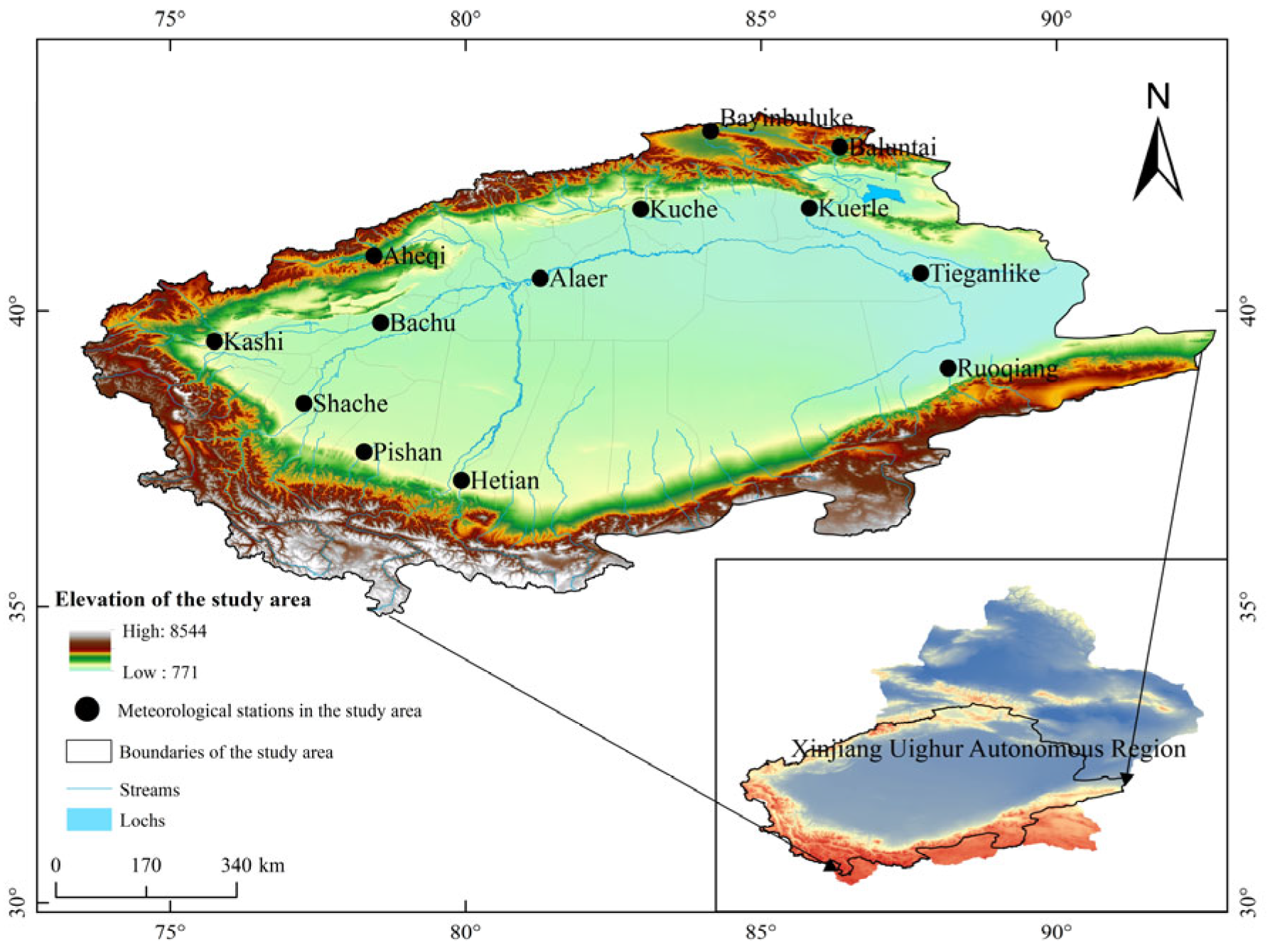
2.1. Data Sources

The employed meteorological data (precipitation and temperature) in this study were obtained from 13 meteorological stations (Table 1) in the Tar River Basin (Figure 1) of the National Center for Environmental Information (NCEI) of the National Oceanic and Atmospheric Administration (NOAA) (https://www.ncei.noaa.gov/data/global-summary-of-the-day/archive/, accessed on 20 September 2024), covering the January 1973–December 2022 period. Digital elevation model (DEM) data, with a 90 m spatial resolution, were obtained from the Geospatial Data Cloud website (http://www.gscloud.cn/, accessed on 10 September 2024). The NDVI data were derived from the NASA Earthdata Search (https://search.earthdata.nasa.gov/search, accessed on 17 October 2024) MOD13A3 dataset, spanning from February 2000 to December 2023, with a spatial resolution of 1 km. Socio-economic data were also obtained from the 2002–2022 Xinjiang Statistical Yearbook, including different indicators (e.g., fiscal revenue and population density). Disaster and calamity data were obtained from the Xinjiang Statistical Yearbook, the China Flood and Drought Hazards Bulletin, and the related literature [18,19,20].

2.2. Research Methodology

2.2.1. Construction of the Comprehensive Drought Index (nSPEI)

The calculation of the drought index in this study was performed according to the following equation [15,21]:
nSPEI   = ( a a + b ×   SPI ) + ( b a + b   ×   SPEI )
where a and b are the calculated weights of the SPI and SPEI, respectively, obtained by dividing the average value of the intensity of the SPI- and SPEI-based light drought or higher class by the lowest drought intensity value. Drought classification was performed according to the SPI SPEI classification standards. The index-based drought levels were classified based on the national meteorological drought level standards of China [22].

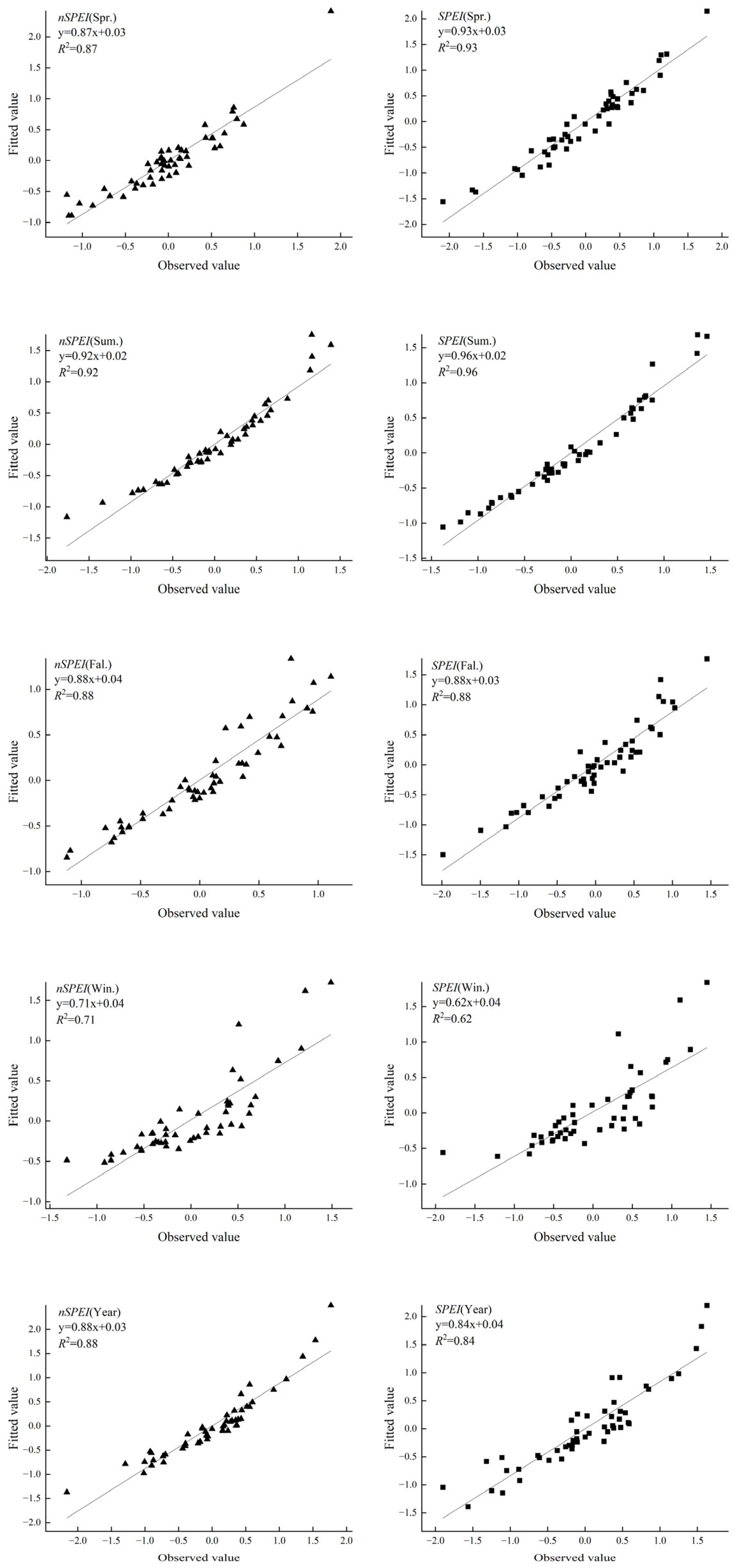
2.2.2. Analysis of Drought Index Applicability

(1)
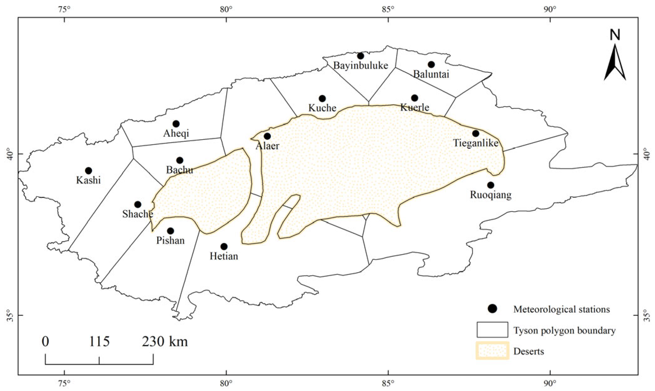
Spatial data processing using the Tyson polygon method
The spatial distribution of the meteorological stations in the study area was not uniform, making the arithmetic mean method inappropriate for computing the distribution of each drought index in the entire study region. The Tyson polygon method can be used to convert climate index points into climate index surfaces, thereby effectively enhancing and reducing the impact weights of sparsely and densely distributed meteorological stations, respectively. Therefore, in this study, ArcGIS 10.8 software was utilized to construct the Tyson polygons, and different area weights were assigned to each weather station site according to the specific calculations listed in a previous study [23]. Figure 2 shows the Tyson polygon division based on the meteorological stations, while Table 2 reports the weights of each meteorological station.
(2)
Proportions of sites with drought events
The ability of each index to reflect drought events was assessed by comparing the proportions of sites where droughts occurred, according to the following calculation formula [20]:
P = n k N × 100 %
where k = 1, 2, 3, 4; nk denotes the number of stations at the k-th drought level; and N denotes the total number of stations in the basin.
The correlation analysis in this paper was performed using the Pearson correlation method, while the statistical significance was explored using the t-test.

2.2.3. Drought Disaster Risk Assessment Method Based on Natural Hazard Theory

(1)
Standardization of the indicator data
Direct comparison between the indicators cannot accurately reflect their impacts on drought disaster risks due to the differences in the measurement units between the indicators. Therefore, the indicator data were standardized according to the correlations between the indicators and the factors [5].
Y i = X i X m i n X m a x X m i n       positive X m a x X i X m a x X m i n       negative
where Yi denotes the standardized value of indicator i; Xi denotes the actual value of indicator i; and Xmax and Xmin are the maximum and minimum values of indicator i, respectively.
(2)
Attribution of weights to the indicators
The application of the AHP method to attribute weights to evaluation indicators may affect subjective evaluation. Hence, to ensure the objectivity of the evaluation results, the EWM was used to objectively assign weights to the indicators. Besides EWM-based objective weights, subjective weights obtained using the AHP method were used to determine the combined weights, thereby comprehensively attributing weights to the different indicators [24]. The combined weights were determined according to the following equation:
W i = W A H P i W E W M i i = 1 n W A H P i W E W M i
where W A H P i denotes the weight obtained using the AHP method; W A H P i denotes the weight obtained using the EWM; and Wi is the combined weight.
(3)
Weighted comprehensive evaluation method
The weighted comprehensive evaluation method has been commonly used to evaluate the importance of factors in drought disaster risk assessments. The index of each factor was calculated based on the indicator weights, according to the following equation [5]:
P i = n j = 1 A i j W A j
where Pi is the evaluation value of factor i; Aij denotes the standardized value of the jth index of factor i; W A j denotes the weight of index j; and n is the number of indexes.
(4)
Drought disaster risk index method
In this study, a drought disaster risk index model was established according to the four factors of comprehensive drought disaster risk, including disaster-causing factor (H), disaster-conceiving environment (E), disaster-bearing body (V), and disaster prevention and mitigation capacity (R) [13]. The calculation formula is as follows:
R I S K = H W H × E W E × V W V × ( 1 R ) W C
where RISK denotes the drought risk index and WH, WE, WV, and WR denote the weights of the evaluation factors, namely, H, E, V, and R, respectively.

3. Results

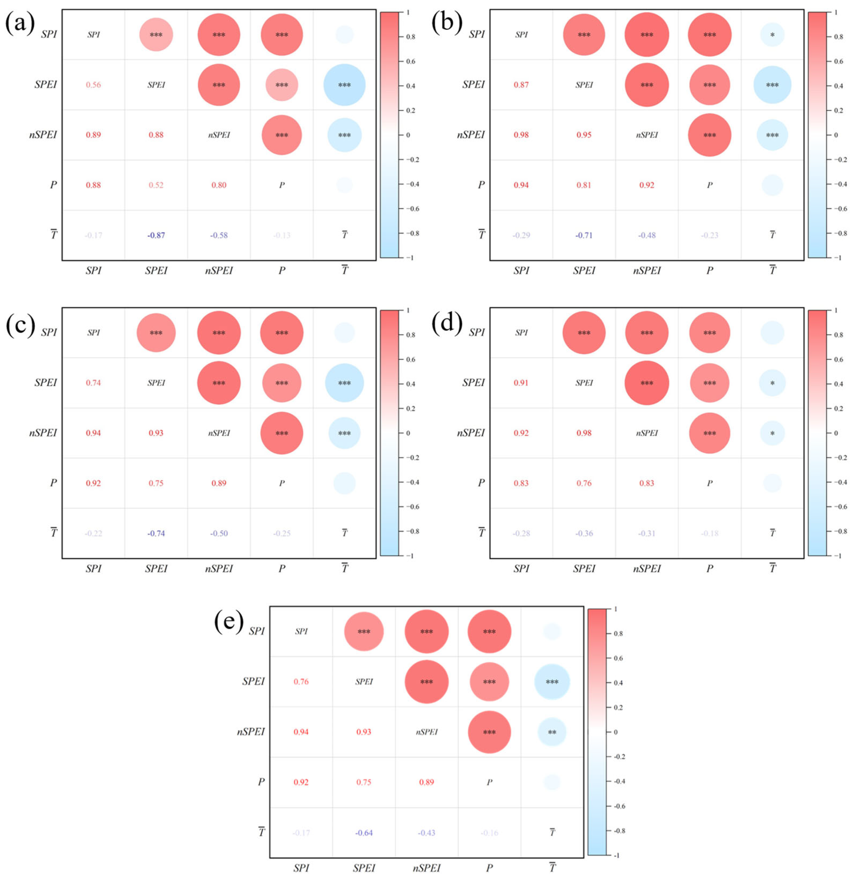
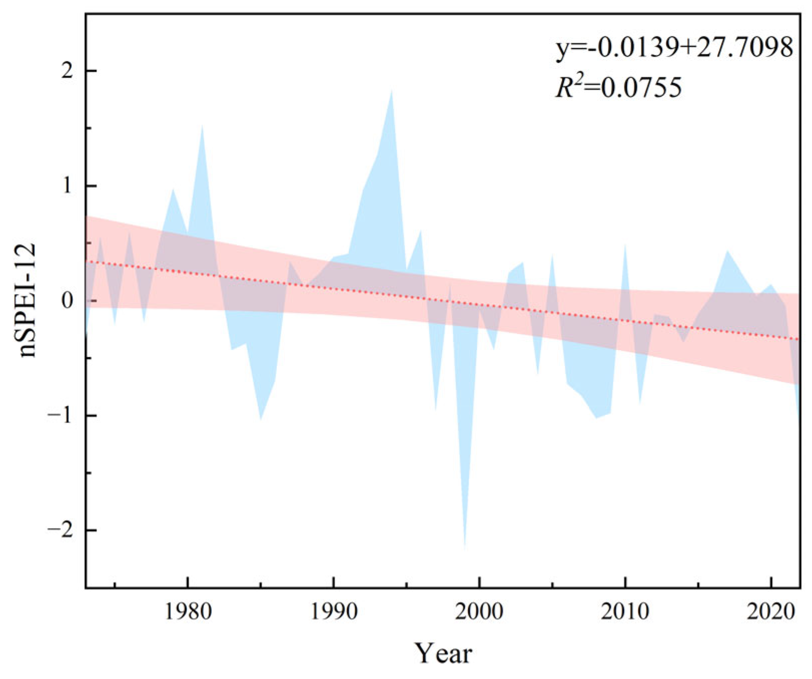
3.1. Relationships Between the Drought Indexes and Meteorological Factors

In this study, the mean annual temperature ( T ¯ ), annual precipitation (P), and drought intensity values were first calculated at each station using the Tyson polygon-based weights before exploring their relationships with the drought indexes through Pearson correlation analysis (Figure 3). The obtained correlation coefficients between the drought indices were all above 0.6, while those of the nSPEI, SPI, and SPEI were over 0.8, suggesting good performance. The drought indices showed strong positive correlations with the precipitation data; among them, the SPI was the most sensitive index to precipitation changes, followed by the nSPEI. The nSPEI values were negatively correlated with T ¯ . On the other hand, the SPEI showed a strong negative correlation with the mean T ¯ values, except in winter, while the SPI was moderately and negatively correlated with summer temperatures. In contrast, statistically insignificant correlations were found at the remaining time scales (p > 0.05). The nSPEI was moderately and negatively correlated with temperatures at all time scales.
The above-mentioned correlation results were different between the nSPEI and SPEI. Therefore, regression analysis was performed in this study to further evaluate their relationships with the precipitation and temperature data (Figure 4). Because the nSPEI and SPEI exhibited different correlation strengths with the precipitation and temperature values, regression analysis was further performed in this study to identify the drought index that has the strongest relationships with the precipitation and temperature data. The R2 values of the nSPEI with the meteorological parameters ranged from 0.76 to 0.97, 0.75 to 0.99, 0.81 to 0.93, and 0.61 to 0.82 in winter, spring, summer, autumn, and winter, respectively. On the other hand, the R2 values of the SPEI with the meteorological data ranged from 0.78 to 0.98, 0.78 to 0.99, 0.75 to 0.92, and 0.39 to 0.75 in spring, summer, autumn, and winter, respectively. The results showed slight differences in R2 values between the two indices and meteorological data, particularly in spring and summer. Figure 5 shows the scatter plots of the observed (watershed mean) and fitted values (calculated using linear regression equations) of the nSPEI and SPEI at five time scales. The observed and fitted values of the winter and annual-scale nSPEI values were in better agreement than those of the SPEI, showing denser scatter points in the spring and summer, with slight differences in the autumn season.
The above-described results indicated that the annual-scale nSPEI was more appropriately correlated with the temperature and precipitation data. The nSPEI values were strongly correlated with precipitation (Figure 3). This finding indicated that precipitation was the main factor controlling drought events in the study area.

3.2. Comparative Analysis of Typical Years with Drought Events

In order to further compare the drought monitoring results by each indicator, 10-year periods with different drought intensities over the 1973–2022 period were considered to calculate the proportions of stations with different drought intensities using Equation (2). In addition, the sensitivity of each indicator to the drought events was assessed by comparing the proportions of stations with drought events.
The index–drought site proportions are reported in Table 3. According to the obtained results, site proportions with SPI-based severe to exceptional drought events were 0, 0, and 100%, respectively. Site proportions with SPEI-based severe drought events were 7.69, 53.85, and 61.54%, respectively. The proportions of sites with severe nSPEI-based drought events were 7.69, 30.77, and 100%. These findings indicated that the nSPEI was suitable for monitoring severe to exceptional drought events in the study area, followed by the SPEI and SPI. Indeed, the SPI did not recognize severe to exceptional drought events in the exceptionally dry year of 2005 or mild drought events in 1978. On the other hand, both nSPEI and SPEI recognized drought events with mild intensities and above.
In summary, the nSPEI was effective in monitoring drought events in extreme drought years. In contrast, the SPEI and SPI slightly overestimated the drought intensities when compared with the actual data, which is consistent with the correlation and regression coefficients of the three indices with the temperature and precipitation data. Furthermore, the drought validation results demonstrated the effectiveness of the nSPEI in monitoring drought events in typical dry years. The regression of the SPEI with the precipitation and air temperature data was better fitted in spring and summer. The poor capacity of the SPI in monitoring drought events might be due to the consideration of a single factor (precipitation), leading to great differences between the predicted and actual drought results. The SPEI, on the other hand, considers the combined effects of precipitation and evaporation, resulting in comparatively more accurate results. Therefore, the annual nSPEI scale was selected as the risk index of the disaster-causing factor in the subsequent analysis of this study.

3.3. Construction of the Drought Disaster Risk Assessment Index and Determination of Associated Weights

In this study, we comprehensively considered the vulnerability of drought-prone environments, the disaster-causing factors, the exposure of drought-affected bodies, and the disaster prevention/mitigation capacity of the Tarim River Basin based on the natural disaster risk theory, as well as other factors, such as the spatiotemporal characteristics of the drought events, geographic and environmental conditions, and socio-economic factors. The obtained results are reported in Table 3. Disaster-causing factor hazard, determined based on the intensity and frequency of drought, reflects the severity of meteorological drought events. In fact, this hazard exhibited strong correlations with the precipitation and temperature data, making it appropriate for describing SPEI- and SPI-based drought events [3,5,13,25,26,27]. The annual nSPEI was selected in this study for its better applicability in the Tarim River Basin. Because nSPEI-12 can reflect annual drought conditions, it was used in this study to calculate the frequency of different drought classes over multiple years. The higher the nSPEI-12 value, the greater the drought-associated hazard. In this paper, the nSPEI-12 values of the studied sites were interpolated in ArcGIS using the inverse weighting method. The average value of all raster points in each region was considered as the frequency of the different drought levels in each county and city.
Disaster-affected bodies’ exposure refers to the contact degrees between disaster-affected bodies and the disaster-causing factor through drought events. Agricultural drought aspects are mainly reflected in cultivated areas, considering economic conditions, sown areas, and arable land conditions in the Tarim River Basin. Therefore, the sown area to the total sown area [6], the sown area [28], the economic density (the gross domestic product (GDP) to the administrative area), and the proportion of the arable land area at the end of the year to the land administrative area were selected in this study. The values of these indicators were all positive. The higher the proportions, the greater the exposure of the disaster-affected bodies.
The vulnerability of the disaster-conceiving environment to drought events was further explored in this study under specific natural and socio-economic conditions. Precipitation is an important factor affecting the occurrence of drought events. The proportions of negative annual precipitation, characterizing the precipitation characteristics of the disaster-bearing environment, were used as a positive indicator. It can be expressed as (measured annual precipitation—historical average of annual precipitation for the same period)/historical average of annual precipitation for the same period), and a negative value indicates that the annual precipitation is significantly lower than the normal value [29]. Vegetation cover can effectively mitigate and prevent the frequency of drought events, making it a negative indicator. In this study, the vegetation cover was obtained using the normalized difference vegetation index (NDVI) [30]. High-altitude areas are more prone to frequent drought events due to insufficient precipitation and significant water loss. Altitude was, therefore, considered a positive indicator in this study.
Disaster prevention and mitigation capacity is the comprehensive effectiveness of a socio-economic–environmental system in reducing drought. Its strength directly determines the degree of drought disaster risks. Indeed, the stronger the capacity, the smaller the disaster-induced loss, and the lower the drought risk.
Grain yields can effectively reflect the synergistic effect of multiple factors, such as farmland quality, soil fertility, climate characteristics, production inputs, and scientific and technological standards. They can not only reflect the light and water utilization efficiency of crops but also indirectly characterize regional crop resistance to drought events. Grain yields can, therefore, be used as a major indicator to assess the effectiveness of drought resistance [9]. The total power of agricultural machinery is the core indicator for measuring the degree of regional agricultural mechanization, directly related to the efficiency of agricultural production. Hence, the larger the total power of agricultural machinery, the higher the level of agricultural development, and the higher the resistance to drought events. The scale of fiscal revenue growth can provide a key financial guarantee for drought mitigation. Increases in the GDP per capita can directly enhance resource allocation capacity for drought mitigation.
The above-mentioned indicators were first standardized before determining the guideline layer and the element layer weights using the hierarchical analysis and entropy methods. Specifically, the hierarchical analysis and entropy methods were used to standardize the layer and indicator weights, respectively. The comprehensive score of each layer was calculated and normalized to obtain the weights of each standardized layer. Finally, the combined weights were determined using Equation (4) (Table 4).

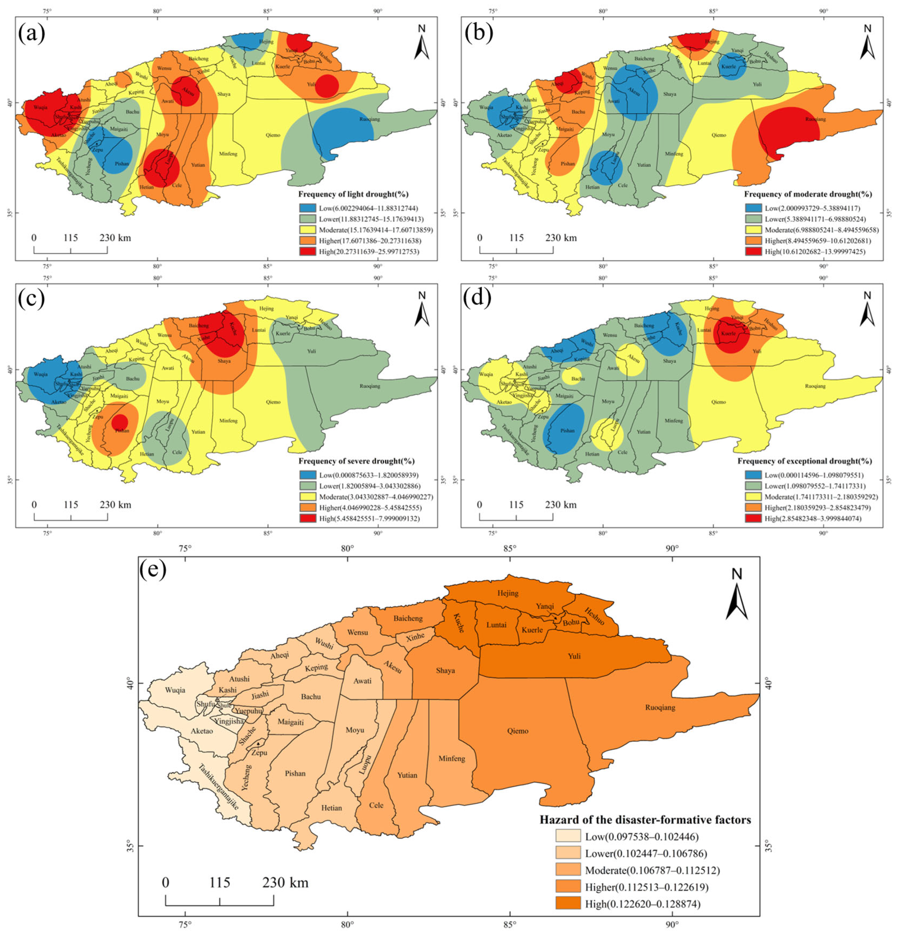
3.4. Analysis of Drought Disaster-Driven Factors

In this study, SPI-12 and SPEI-12 were calculated using the collected meteorological data from 13 meteorological stations to construct the nSPEI-12. The inter-annual changes in the nSPEI-12 in the Tarim River Basin are shown in Figure 6. The results showed a decreasing trend of the nSPEI over the past 50 years by −0.139/10 years. In addition, there was an aridity trend in the Tarim River Basin.
The frequencies of the four drought classes in the study area, namely, mild, moderate, severe, and extreme drought, were interpolated using the inverse distance weighting method. In addition, the frequency of each drought intensity was divided into five classes from low to high using the natural breakpoint grading method. Subsequently, the standardized values of the four drought frequencies were used to compute a comprehensive score using the weighted comprehensive evaluation method (Equation (5)). The spatial distribution map of the disaster-causing factor hazard index was obtained and divided into five grades using the natural breakpoint grading method. The spatial distribution map of the different drought grades is shown in Figure 7. According to the obtained results, the low and medium–low light drought events were mainly observed in the Kashgar region in the western part of the Hotan region, as well as in the northwestern and southeastern parts of Bayin’guoleng Mongol Autonomous Prefecture (Figure 7a), showing a drought frequency range of 6–15%, corresponding to 3–7.5 events/50a. The high-occurrence areas of light drought events were mainly observed in Wuqia County, Aksu City, and Yuli County, with drought frequencies in the ranges of 20–26% and 10–13 times/50a. The high-occurrence area of medium drought events was found mainly in Hejing County, Ruoqiang County, and Aheqi County, with drought frequency ranges of 11–14% and 10–13 times/50a (Figure 7b). According to Figure 7c, the high-occurrence area of severe drought events, on the other hand, was found in different parts of the study area, covering different counties (e.g., Kuqa County and Baicheng County). The overall performance of high and low values was found in the central and western parts of the Tarim River Basin, respectively. The high-incidence area of extreme drought events was found mainly in Korla City and Yanqi Hui Autonomous County, with drought frequency ranges of 3–4% and 1.5–2 times/50a (Figure 7d).
Figure 7e shows the hazard evaluation map of the disaster-causing factors. The second-highest and high-hazard zones of the drought-disaster-causing factors were observed in the eastern part of the Aksu region and Bayinguoleng Mongol Autonomous Prefecture of the Tarim River Basin. In general, the spatial distribution of the disaster-causing factor risks showed a gradually increasing trend from west to northeast, according to the spatial distribution of precipitation and the drought class frequencies.

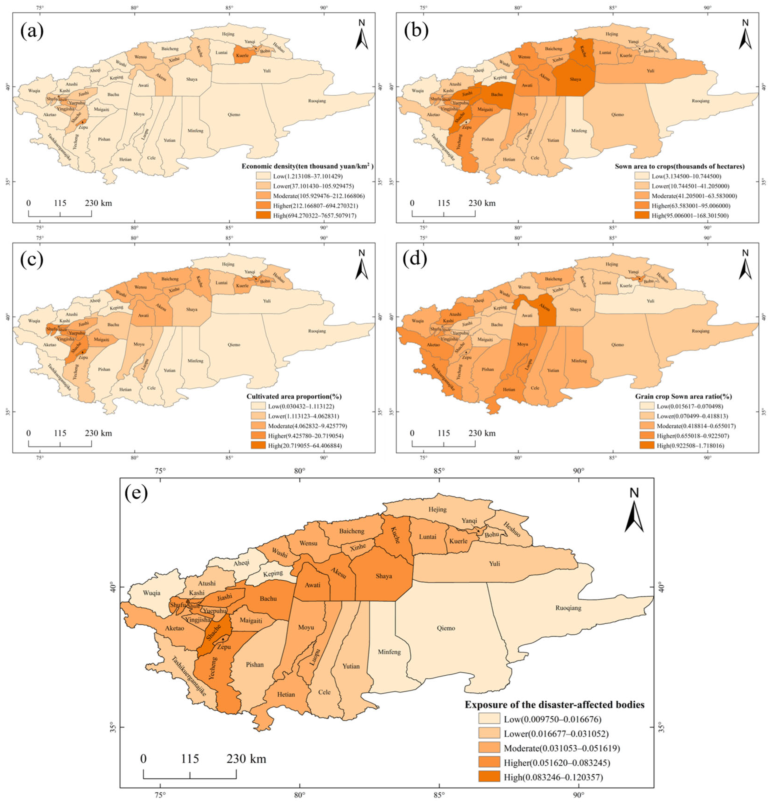
3.5. Exposure Analysis of the Disaster-Affected Bodies

Figure 8a–e show the spatial distributions of the multi-year economic density, crop sown areas, cultivated land area proportions, grain crop Sown area ratio, and disaster-affected bodies exposure, respectively. Korla, Kashgar, and Zepu counties had high economic density, while Aksu City was characterized by high grain crop area ratios. Areas with the second-highest and medium grain crop area ratios were distributed in the central and western parts of the Tarim River Basin. Kuche, Shaya, and Bachu counties were also characterized by high-crop areas, followed by the Kashgar and Aksu regions. Yanqi Hui Autonomous County, Zepu County, and Kashgar City exhibited high cropland areas. As it can be seen from Figure 8e, the second-highest and high-exposure counties and cities were mainly distributed in the Aksu and Kashgar regions, while the medium-exposure area was mainly distributed in the central part of the Hotan region, the northern part of Bayinguoleng Mongol Autonomous Prefecture, and the southern part of Kizilsu Kirghizi-Zizhizhou Autonomous Prefecture.

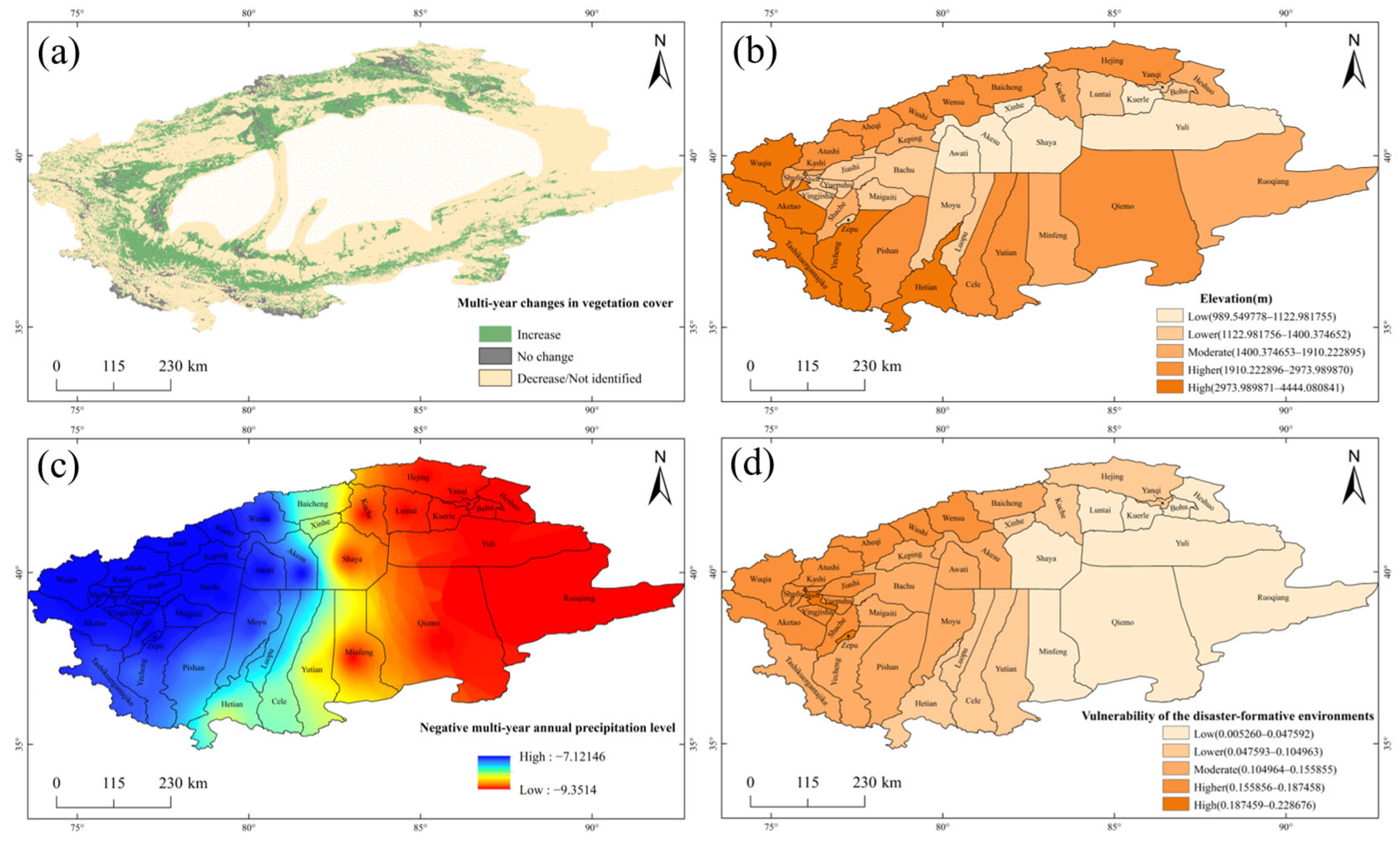
3.6. Vulnerability Analysis of the Disaster-Formative Environments

Figure 9a–d show the spatial changes in the multi-year vegetation cover, elevation, negative multi-year annual precipitation level, and disaster-formative environment vulnerability, respectively. The results showed an increase in the vegetation cover in the Tarim River Basin by 25.7% over the 2000–2023 period (Figure 9a) and remained unchanged at 4.5%. In contrast, there were no obvious changes in the vegetation cover in the remaining parts of the study area. The highest elevation of the Tarim River Basin is generally found in the southern and eastern parts of the study area, while the lowest topography is observed in the northern and western parts (Figure 9b). The negative average multi-negative precipitation values of the Tarim River Basin were found in areas with light to medium drought events (Figure 9c). In fact, the precipitation deficit gradually became heavier from west to east. Kashgar City, Zepu County, and Shule County were located in vulnerable areas to drought events, while Kizilsu-Kirghiz Autonomous Prefecture was located in an area with a comparatively lower vulnerability level to droughts (Figure 9d).

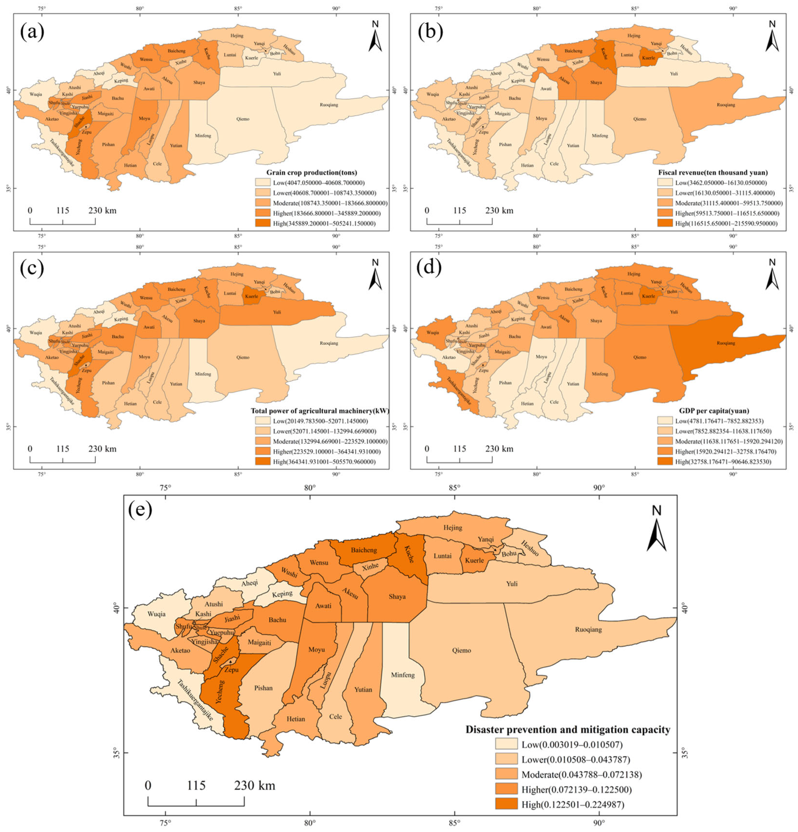
3.7. Analysis of Disaster Prevention and Mitigation Capacity

Figure 10a–e show the spatial distributions of grain crop production, financial income, total power of agricultural machinery, GDP per capita, and disaster prevention and mitigation capacity, respectively. Shache County had the highest grain crop production (Figure 10e). On the other hand, counties and cities with medium and high grain crop production are mainly located in the southwestern and northern parts of the Tarim River Basin, while the lowest grain crop production was found in the southeastern part of the study area. Kuche, Korla, and Kashgar cities were characterized by high revenue, followed by areas in the northern part of the Tarim River Basin (Figure 10b). Shache County and Korla City exhibited high total power of agricultural machinery, followed by the northern and western parts of the Tarim River (Figure 10c). The high GDP values were found in Korla City and Ruoqiang County (Figure 10d). It is worth noting that the GDP per capita experienced a gradual increase from the western region to the eastern region, while the lowest values were found in the southern region. According to Figure 10e, the highest and second-highest prevention and mitigation capacity values were mainly found in the northern and southwestern parts of the Tar River Basin, where Baicheng County, Kuche County, Shache County, and Yecheng County are located. In general, the disaster prevention and mitigation capacity of the Tarim River Basin exhibited an increasing–decreasing trend from the eastern part to the western part of the Basin.

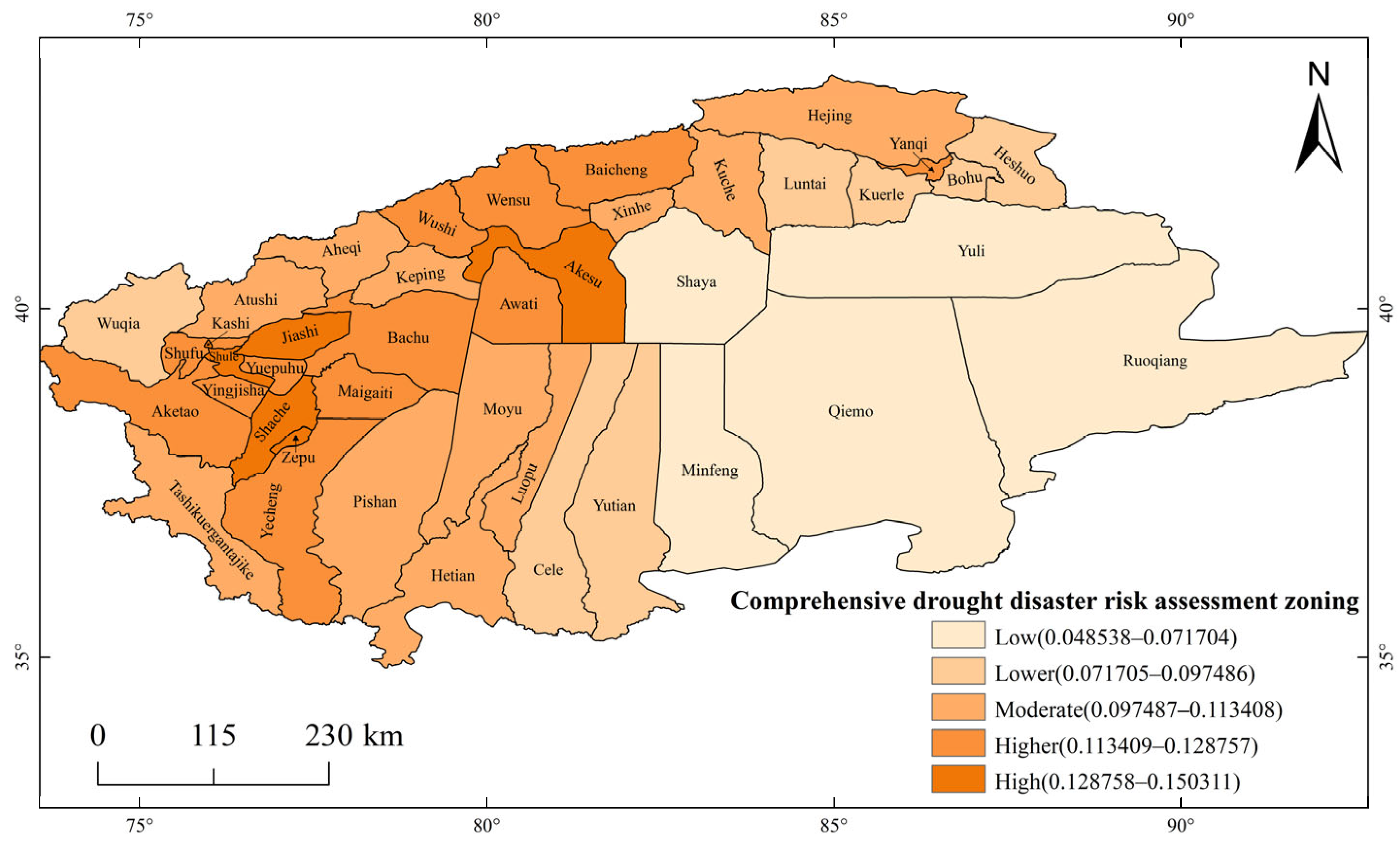
3.8. Drought Disaster Risk Assessment and Zoning

The drought disaster risks were calculated in this study using Equation (6) to generate the average annual drought disaster risk map of the 2002–2021 period (Figure 11). The high-risk areas consisted of Kashgar City, Aksu City, Shule County, Shache County, Zepu County, and Gashi County. The second-highest risk areas were mainly concentrated in the Aksu and Kashgar regions, while the medium drought risk areas were observed in the western and northeastern parts of the Tarim River Basin. The average annual drought risk in the Tar River Basin showed a gradual increase from the southeastern part to the northwestern part.

4. Discussion

In this paper, the nSPEI was constructed based on the SPEI and SPI to assess the effects of different factors on drought events in the Tarim River Basin. The nSPEI-12 results highlighted an aridification trend in the study area, which is consistent with the results revealed by Wang [31] in the Tarim River Basin. In this paper, the drought disaster risks in the Tarim River Basin were comprehensively analyzed. Specifically, the impacts of drought-causing factors, disaster-affected bodies exposure, disaster-conceiving environment vulnerability, and disaster prevention/mitigation capacity were quantified to explore the spatial distributions of comprehensive drought disaster risk in the Tarim River Basin over the 2001–2021 period. The final drought risk assessment results were presented using the drought composite index and sub-composite index, reflecting drought severity and the impacts of its major influencing factors, respectively, in the different parts of the study area. This study provides a scientific basis and action guide for drought mitigation efforts. For example, the risk induced by drought-causing factors was higher in Kuqa City due to the occurrence of low negative multi-year precipitation levels. It is therefore crucial to conduct future studies on meteorological and hydrological forecasting work in order to comprehensively explore and mitigate the impacts of drought events at early stages. The exposure risk factor was higher in Shaya County due to the presence of relatively large crop-sowing areas, resulting in potentially high drought-induced economic losses. This highlights the importance of promoting appropriate irrigation practices to ensure sufficient crop water supplies. According to the comprehensive drought risk map, areas with high drought risks in the Tarim River Basin were mainly concentrated in the western and northern parts, while comparatively lower drought risks were found in the southeastern part of the basin. This finding is, in fact, in line with those revealed in previous studies on drought risks in the Tarim River Basin in 2010 [3], showing high and low drought risk levels in the western and southeastern parts of the basin, respectively. These findings provide guidance for identifying weak drought responses in counties and cities, thereby informing effective mitigation strategies. Our methodological approach used in this study revealed the major driving mechanisms of drought risks in the Tarim River Basin, integrating meteorological, ecological, socio-economic, and other multidisciplinary perspectives. Nevertheless, further related studies are still needed, taking into account the specific characteristics of the basin to enhance the accuracy of drought-related factor data, providing further insights into drought risk management. Moreover, such studies can be useful for spatially targeted and temporally adaptive decision support, thereby ensuring effective ecological priority-oriented drought risk management.

5. Conclusions

In this study, we selected 12 indicators, including nSPEI-12 and vegetation cover, to construct a drought risk evaluation index using the EWM and AHP methods. This drought risk index was used to assess the drought risks in the Tarim River Basin. In addition, the impacts of drought-causing factors, disaster-affected bodies exposure, disaster-prone environments, and disaster prevention/mitigation capacity were further explored in this study. The following conclusions were drawn in this study:
(1)
The Tarim River Basin is characterized by low precipitation amounts. The greatest and lowest overall performance was observed mainly in the western part of the basin, which is consistent with the spatial distribution of the hazard level of the drought-disaster-causing factors. Indeed, an aridification trend was found in the western and eastern parts of the basin. In general, the study area exhibited a spatial aridification trend. The results highlighted an increase in the vegetation cover in the Tarim River basin by 25.7% from 2000 to 2023 and remained unchanged at 4.5%. On the other hand, a decreasing trend of the vegetation cover was found in the remaining parts of the study area.
(2)
The light drought class exhibited high frequencies in the western, central, and northeastern regions of the Tarim River Basin. On the other hand, the highest frequencies of the moderate drought class were found in the northwestern, northeastern, and southeastern parts, while those of the severe drought class were observed in the northeastern and southwestern parts. In contrast, the highest frequencies of the exceptional drought class were observed only in the northeastern part of the basin. The drought risk-causing factors were high in the northeastern part of the Tarim River Basin. The greatest disaster-affected bodies exposure exhibited a decreasing trend from the northwest to the eastern part. The greatest disaster prevention/mitigation capacity was found in the northern and southwestern parts of the basin. On the other hand, the vulnerability level of the disaster-conceiving environment had a decreasing trend from the northwestern to the southeastern parts of the study area.
(3)
The western and northern parts of the Tarim River Basin exhibited the highest drought risk levels, followed, respectively, by the northeastern and southeastern parts.

Author Contributions

Conceptualization, X.K., Q.L., H.T. and M.A.; methodology, X.K. and M.A.; data organization, X.K., Q.L., H.T. and M.A.; resources, Q.L., H.T. and M.A.; writing—original draft preparation, X.K., Q.L., H.T. and M.A.; writing—review and editing, X.K., Q.L., H.T. and M.A.; project management, Q.L., H.T. and M.A. All authors have read and agreed to the published version of the manuscript.

Funding

This research was funded by the Xinjiang Uygur Autonomous Region Key Research and Development Program Project, grant number 2024B03029-2; the Xinjiang Uygur Autonomous Region Natural Science Foundation Youth Science Fund Project, grant number 2022D01B86; and the Xinjiang Uygur Autonomous Region Major Science and Technology Special Project, grant number 2023A02002-1.

Institutional Review Board Statement

Not applicable.

Informed Consent Statement

Not applicable.

Data Availability Statement

The employed meteorological data in this study were obtained from 13 meteorological stations in the Tar River Basin of the National Center for Environmental Information (NCEI) of the National Oceanic and Atmospheric Administration (NOAA) (https://www.ncei.noaa.gov/data/global-summary-of-the-day/archive/, accessed on 9 June 2025), covering the 1973–2022 period. Digital elevation model (DEM) data, with a 90 m spatial resolution, were obtained from the Geospatial Data Cloud website (http://www.gscloud.cn/, accessed on 9 June 2025). The NDVI data were derived from the NASA Earthdata Search (https://search.earthdata.nasa.gov/search, accessed on 9 June 2025) MOD13A3 dataset. The socio-economic data provided in this study can be obtained from the corresponding author. The data are not available to the public as they are from the Xinjiang Statistical Yearbook.

Conflicts of Interest

The authors declare no conflicts of interest.

References

  1. Feng, L.C.; Wang, Y.J. Study on the Spatiotemporal Evolution Characteristics of Meteorological Drought in the Tarim River Basin. China Water Power Electrif. 2020, 11, 26–29+17. [Google Scholar] [CrossRef]
  2. Zhang, L.; Guo, F.Q.; Wei, G.H. Research on Emergency Strategies for Drought Mitigation in the Tarim River Basin, Xinjiang. Groundwater 2024, 46, 217–219+313. [Google Scholar] [CrossRef]
  3. Sun, P.; Zhang, Q.; Deng, X.Y.; Bai, Y.G.; Zhang, J.H. Drought Risk Assessment and Regionalization in the Tarim River Basin. J. Sun Yat-sen Univ. (Nat. Sci. Ed.) 2014, 53, 121–127. [Google Scholar] [CrossRef]
  4. Tsakiris, G. Drought risk assessment and management. Water Resour. Manag. 2017, 31, 3083–3095. [Google Scholar] [CrossRef]
  5. Cheng, Y.P. Agricultural Drought Risk Assessment and Regionalization in Henan Province. Master’s Thesis, North China University of Water Resources and Electric Power, Zhengzhou, China, 2016. [Google Scholar]
  6. Wu, D.; Zhang, H.T.; He, B.; Wang, Q.; Zhou, B. Agricultural Drought Risk Assessment and Regionalization in Shaanxi Province Based on Fuzzy Clustering Iterative Model. Agric. Res. Arid Areas 2018, 36, 230–241. [Google Scholar]
  7. Jia, J.Y.; He, N.; Han, L.Y.; Zhang, Q.; Zhang, Y.F.; Hu, J.M. Drought Risk Analysis of Maize in Southwest China Based on Natural Disaster Risk Theory and ArcGIS. Trans. Chin. Soc. Agric. Eng. 2015, 31, 152–159. [Google Scholar]
  8. Wu, Z.Y.; Fan, S.Q.; He, H.; Li, Y. Risk Regionalization of Agricultural Drought Disaster in Hunan Province. Water Resour. Prot. 2023, 39, 31–39. [Google Scholar] [CrossRef]
  9. Zheng, F.; Ma, L.W. Agricultural Drought Risk Assessment and Regionalization in Ningxia. J. Agric. Disaster Res. 2021, 11, 152–155. [Google Scholar]
  10. Dong, T.T. Research on Agricultural Drought Risk Assessment in Liaoning Province. Water Resour. Dev. Res. 2017, 17, 54–56+60. [Google Scholar] [CrossRef]
  11. Huang, Z.L.; Cheng, K.; Ruan, X.L. Fire Safety Assessment of Urban Utility Tunnels Based on Analytic Hierarchy Process. Urban Archit. 2025, 22, 65–67. [Google Scholar] [CrossRef]
  12. Feng, Y.T.; Li, C.X.; Chen, S.L. Comprehensive Evaluation and Ranking Analysis of Urban Digital Economy Development in Guangdong Province Based on Entropy Method. Mod. Bus. 2025, 4, 161–164. [Google Scholar] [CrossRef]
  13. Liu, X.F.; Zhu, X.F.; Pan, Y.Z.; Xia, X.S. Framework and Application of Agricultural Drought Risk Assessment in Henan Province. J. Beijing Norm. Univ. (Nat. Sci.) 2015, 51 (Suppl. S1), 8–12. [Google Scholar] [CrossRef]
  14. Li, H.J.; Jiang, Z.H.; Bai, Y.G. Improvement and Evaluation of Palmer Drought Severity Index in the Tarim River Basin. Plateau Meteorol. 2015, 34, 1057–1064. [Google Scholar]
  15. Li, C.J.; Bo, Y.P.; An, M.Y.; Peng, Y. Evolution of Drought Characteristics in Guizhou Province Based on SPI. Haihe Water Resour. 2025, 2, 82–88. [Google Scholar]
  16. Tang, M.; Zhang, B.; Zhang, Y.Z.; Wang, G.Q.; Ma, B.; Jia, Y.Q. Assessment of Spring and Summer Meteorological Drought Characteristics in Eastern Agricultural Regions of Qinghai Province Based on SPEI and SPI. J. Nat. Resour. 2017, 32, 1029–1042. [Google Scholar] [CrossRef]
  17. Zhang, Y.; Wang, X.J.; Zhang, X.; Yi, Z.B.; Zhao, Y.J. Determination of Meteorological Drought Indices and Analysis of Drought Characteristics in the Oasis Agricultural Region of Northern Xinjiang. Desert Oasis Meteorol. 2024, 18, 133–142. [Google Scholar]
  18. Turghun, A. Characteristics and Causes of Drought Disasters in the Tarim River Basin (Characterization and Causes of Drought Disasters in the Tahe River Basin). Water Resour. Plan. Des. 2015, 11, 18–21. [Google Scholar] [CrossRef]
  19. Musha, R.Z. Characteristics and Causes of Drought Disasters in the Tarim River Basin (Characteristics of Drought Disaster in the Tarim River Basin and Analysis of Its Causes). Master’s Thesis, Xinjiang Agricultural University, Urumqi, China, 2013. [Google Scholar]
  20. Feng, Y.; Xue, L.Q.; Zhang, L.C. Comparative Analysis of Three Meteorological Drought Indices in the Tarim River Basin. Water Resour. Power 2018, 36, 23–26+142. [Google Scholar] [CrossRef]
  21. Wang, Y.L.; Wang, R.; Shan, F.J.; Zhang, X.X.; Zhao, Y.; Sun, Y. Analysis of Drought Characteristics of Maize in Liaoning Province Based on SPEI Index. J. Liaoning Univ. Technol. (Nat. Sci. Ed.) 2024, 44, 273–280. [Google Scholar] [CrossRef]
  22. GB/T 20481-2017; Classification of Meteorological Drought. Standards Press of China: Beijing, China, 2017.
  23. Wang, Y.D. Calculation of Regional Average Rainfall Using Thiessen Polygon Method Based on ArcGIS. Jilin Water Resour. 2014, 6, 58–60+63. [Google Scholar] [CrossRef]
  24. Wang, Y.; Jin, M.J.; Ding, W.; Li, X.; Zhao, Y. Construction of Competency Index System for Hospital Infection Prevention and Control Personnel Based on Analytic Hierarchy Process-Entropy Method. China Med. Her. 2024, 21, 134–138. [Google Scholar] [CrossRef] [PubMed]
  25. Yang, W.; Zhang, L.; Liang, C. Agricultural Drought Disaster Risk Assessment in Shandong, China; Springer: Berlin, Germany, 2022. [Google Scholar] [CrossRef]
  26. Shi, Q. Risk Assessment and Regionalization of Drought Disasters in Heilongjiang Province. Master’s Thesis, Heilongjiang University, Harbin, China, 2024. [Google Scholar] [CrossRef]
  27. Mu, Z.X.; Tian, X.J.; Zhang, Y.X.; Ding, Z.L. Drought Disaster Risk Assessment and Regionalization in the Ili River Basin Based on ERA5 Reanalysis Data. Water Resour. Power 2024, 42, 28–32. [Google Scholar] [CrossRef]
  28. He, B.; Wang, Q.J.; Wu, D.; Su, L.J.; Shan, Y.Y. Agricultural Drought Risk Assessment in Shaanxi Province Based on Principal Component Analysis and Analytic Hierarchy Process. Agric. Res. Arid Areas 2017, 35, 219–227. [Google Scholar]
  29. Ren, W.; Qiu, M.J.; Tan, Y.J.; Chen, B.W. Drought Risk Analysis of Summer Maize at Main Growth Stages in Zhumadian City Based on Precipitation Anomaly Percentage. J. Hunan Ecol. Sci. 2024, 11, 85–91. [Google Scholar] [CrossRef]
  30. Tian, Y.; Ji, Z.W.; Wang, D.W.; Xie, Y.Q. Vegetation Coverage and Ecological Water Requirement in the Yellow River Delta. Res. Soil Water Conserv. 2025, 32, 168–175+188. [Google Scholar] [CrossRef]
  31. Wang, T.T. Study on Potential Evapotranspiration and Drought Characteristics in the Tarim River Basin. Master’s Thesis, Shanghai Normal University, Shanghai, China, 2022. [Google Scholar] [CrossRef]
Figure 1. Spatial distribution of the meteorological stations in the study area.
Agriculture 15 01287 g001
Figure 2. Tyson polygonal division of the meteorological stations in the Tarim River Basin.
Agriculture 15 01287 g002
Figure 3. Correlation coefficients between the seasonal-scale drought indices and meteorological factors in spring (a), summer (b), fall (c), winter (d), and the entire year (e); *: p ≤ 0.05 **: p ≤ 0.01 ***: p ≤ 0.001.
Agriculture 15 01287 g003
Figure 4. Scatter plots of the SPEI and nSEPI versus the temperature and precipitation data at five time scales and the different sites.
Agriculture 15 01287 g004
Figure 5. Comparison between annual observed and fitted nSPEI and SPEI values.
Agriculture 15 01287 g005
Figure 6. Inter-annual variation in the nSPEI-12 values.
Agriculture 15 01287 g006
Figure 7. Spatial distribution of the drought frequency and disaster-formative risk factors in the Tarim River Basin.
Agriculture 15 01287 g007
Figure 8. Spatial distributions of disaster-Affected Bodies exposure indicators in the study area.
Agriculture 15 01287 g008
Figure 9. Spatial distributions of indicators used to comprehensively assess drought vulnerability in the Tarim River Basin.
Agriculture 15 01287 g009
Figure 10. Spatial distributions of the indicators and disaster prevention/mitigation capacity in the Tarim River Basin.
Agriculture 15 01287 g010
Figure 11. Comprehensive drought disaster risk map.
Agriculture 15 01287 g011
Table 1. Information of the meteorological stations in the Tarim River Basin.
Station NameDistrict Station NumberLongitude/°Latitude/°Elevation/m
Baluntai51,46786.333342.76671732.4
Bayinbuluike51,54284.150043.03332458.0
Kuche51,64482.966741.71671081.9
Kuerle51,65685.816741.7333899.8
Kashi51,70975.750039.48331385.6
Aheqi51,71178.450040.93331985.1
Bachu51,71678.566739.80001116.5
Alaer51,73081.266740.55001012.2
Tieganlike51,76587.700040.6333846.0
Ruoqiang51,77788.166739.0333887.7
Shache51,81177.266738.43331231.2
Pishan51,81878.283337.61671375.4
Hetian51,82879.933337.13331375.0
Table 2. Tyson polygon-based weights of the meteorological stations.
AheqiAlaerBachuBaluntaiBayinbulukeHetianKashiKucheKuerlePishanRuoqiangShacheTieganlike
W0.0480.0700.0370.0330.0300.1760.1030.0440.0320.0810.2150.0760.054
Table 3. Proportion analysis of sites with SPI-, SPEI-, and nSPEI-based drought events.
Particular YearDrought DegreesSPI Index/%SPEI Index/%nSPEI Index/%
MildModerate Severe to ExceptionalMildModerate Severe to Exceptional MildModerate Severe to Exceptional
1973Mild 23.0823.087.6915.3823.087.6923.0823.080.00
1978Mild0.000.000.0023.080.000.007.690.000.00
1985Severe 15.3830.7753.8546.1523.080.0030.7738.4623.08
1999Exceptional0.000.00100.0015.3830.7753.850.000.00100.00
2005Exceptional7.690.000.000.000.007.690.000.007.69
2007Exceptional23.0815.3815.380.007.6961.547.6923.0830.77
2008Severe38.467.690.0015.3830.7738.4615.3846.157.69
2011Severe23.0815.387.6938.467.6923.0823.087.6923.08
2020Severe7.697.690.0015.380.007.6915.380.007.69
2022Severe38.4630.770.007.690.0076.9215.3823.0846.15
Table 4. Indicator framework for drought disaster risk evaluation.
Target LevelsStandardized LayersWeightingIndicatorsWeightingCorrelations
Drought riskHazard of the disaster-formative factors0.493Light drought0.020Positive
Moderate drought0.064Positive
Severe drought0.066Positive
Exceptional drought0.102Positive
Exposure of the disaster-affected bodies0.162Grain cropSown area ratio0.041Positive
Sown area to crops0.082Positive
Economic density0.029Positive
Cultivated area proportion0.068Positive
Vulnerability of the disaster-formative environments0.267Proportion of negative annual precipitation level0.120Positive
Vegetation cover0.105Negative
Elevation0.039Positive
Disaster prevention and mitigation capacity0.078Fiscal revenue0.024Positive
Grain crop production0.150Positive
Total power of agricultural machinery0.071Positive
GDP per capita0.019Positive
Disclaimer/Publisher’s Note: The statements, opinions and data contained in all publications are solely those of the individual author(s) and contributor(s) and not of MDPI and/or the editor(s). MDPI and/or the editor(s) disclaim responsibility for any injury to people or property resulting from any ideas, methods, instructions or products referred to in the content.

