
Soil Salinity Inversion Based on a Stacking Integrated Learning Algorithm

Abstract
1. Introduction
2. Materials and Methods
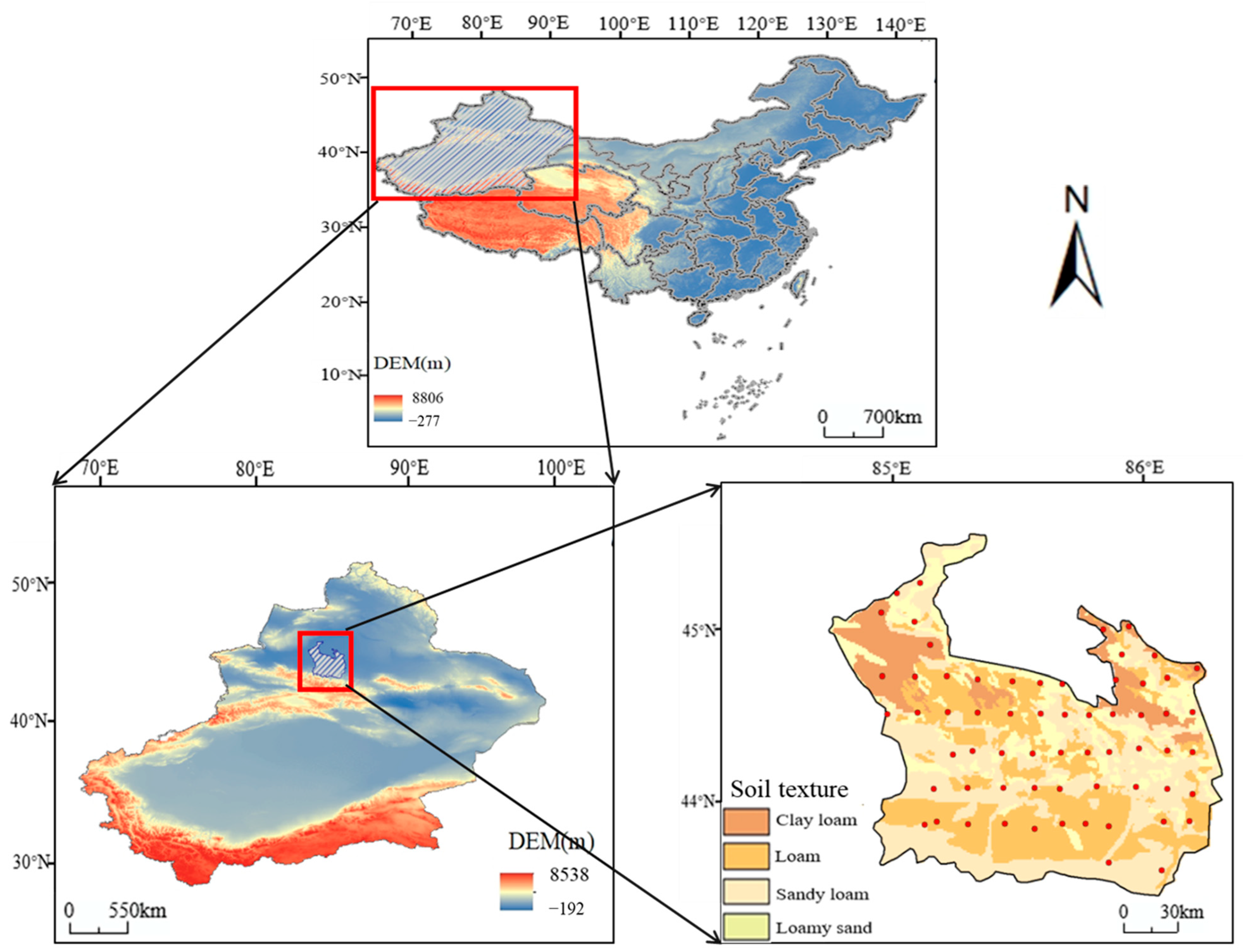
2.1. Study Area
2.2. Data Sources
2.3. Salinity Index Construction
2.4. Model Construction and Accuracy Evaluation
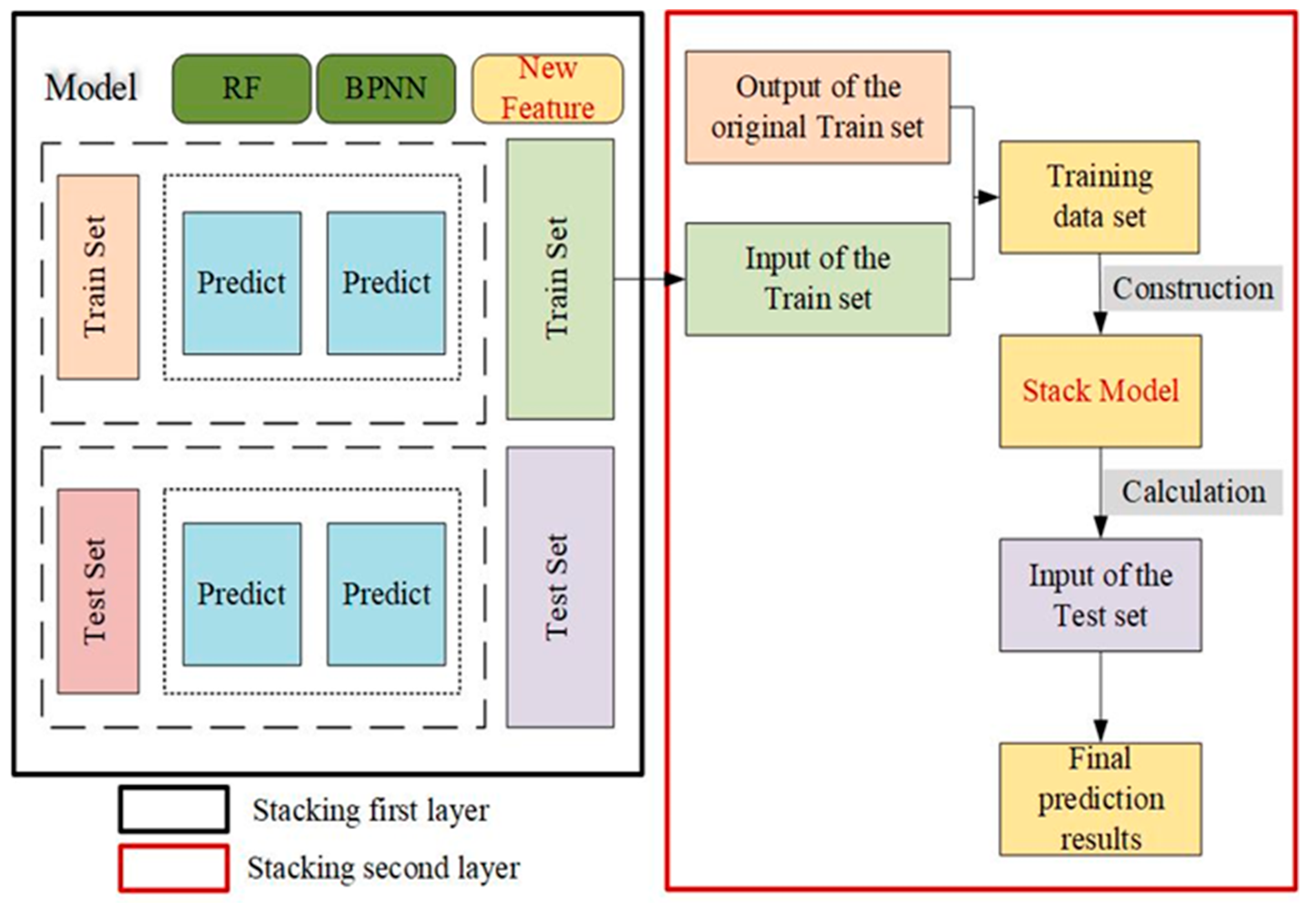
2.4.1. Model Construction and Model Parameters Determination
2.4.2. Selection of Model Performance Indicators
3. Results
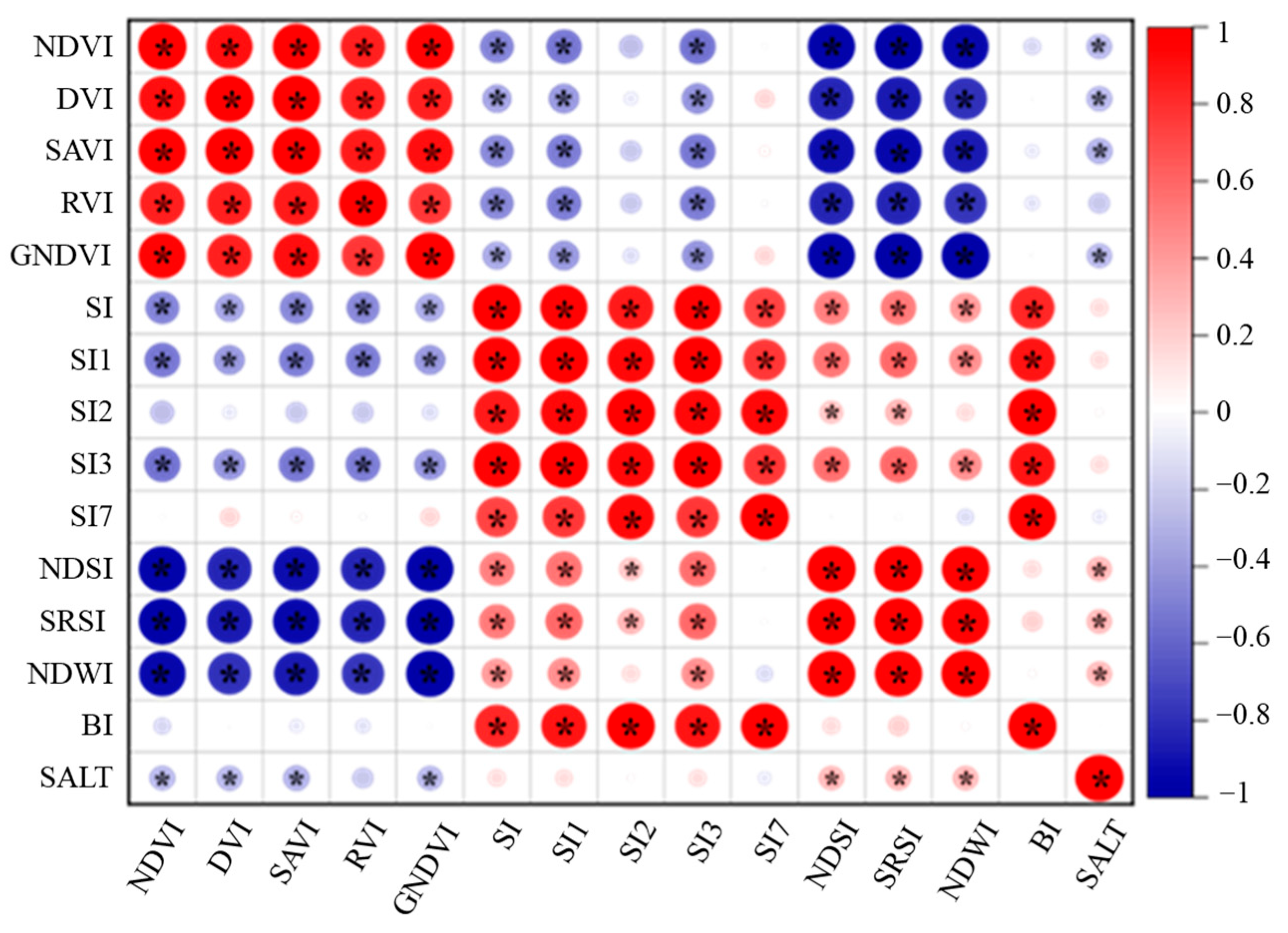
3.1. Correlation Analysis between Spectral Indexes and Soil Salinity
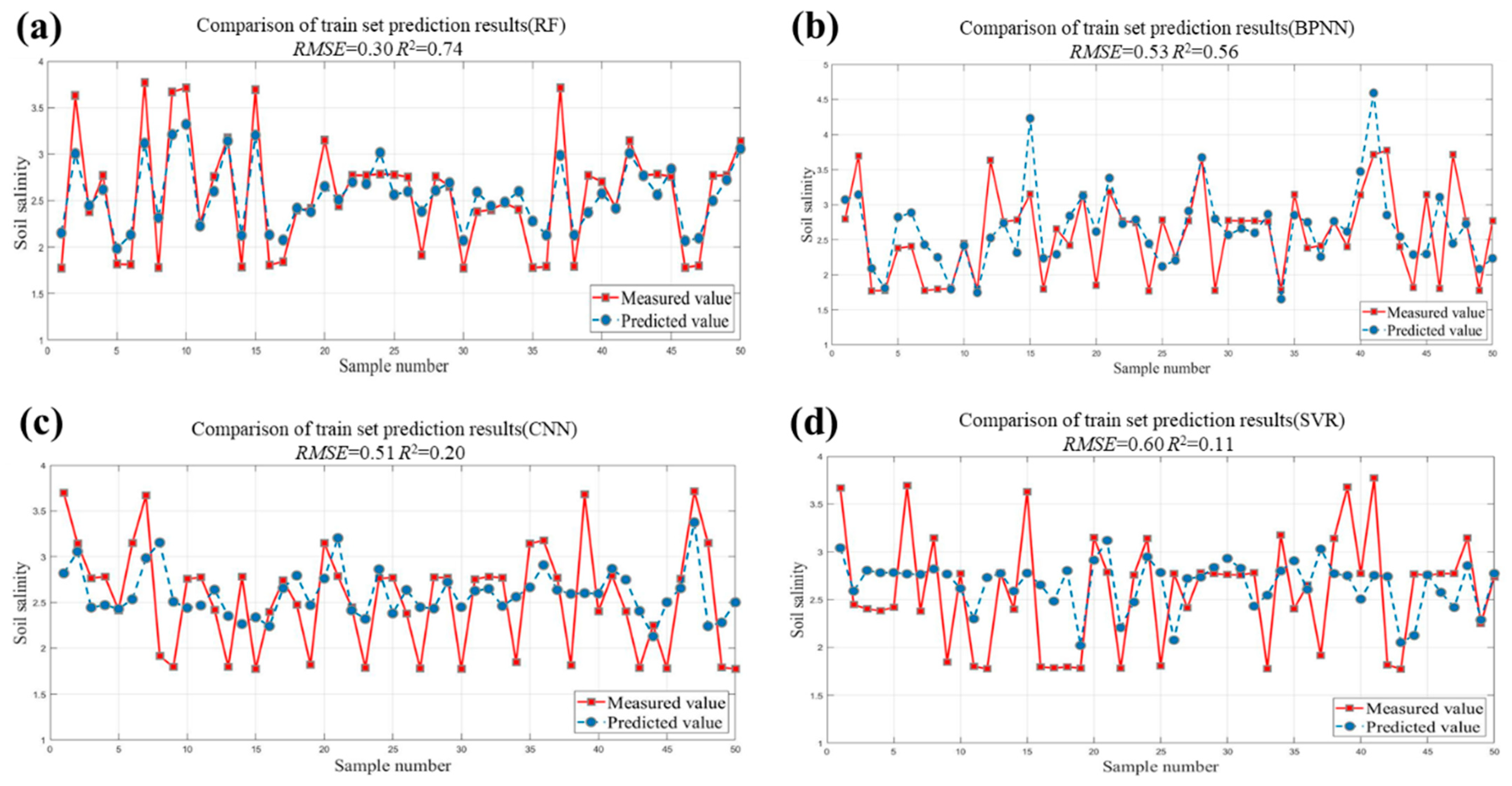
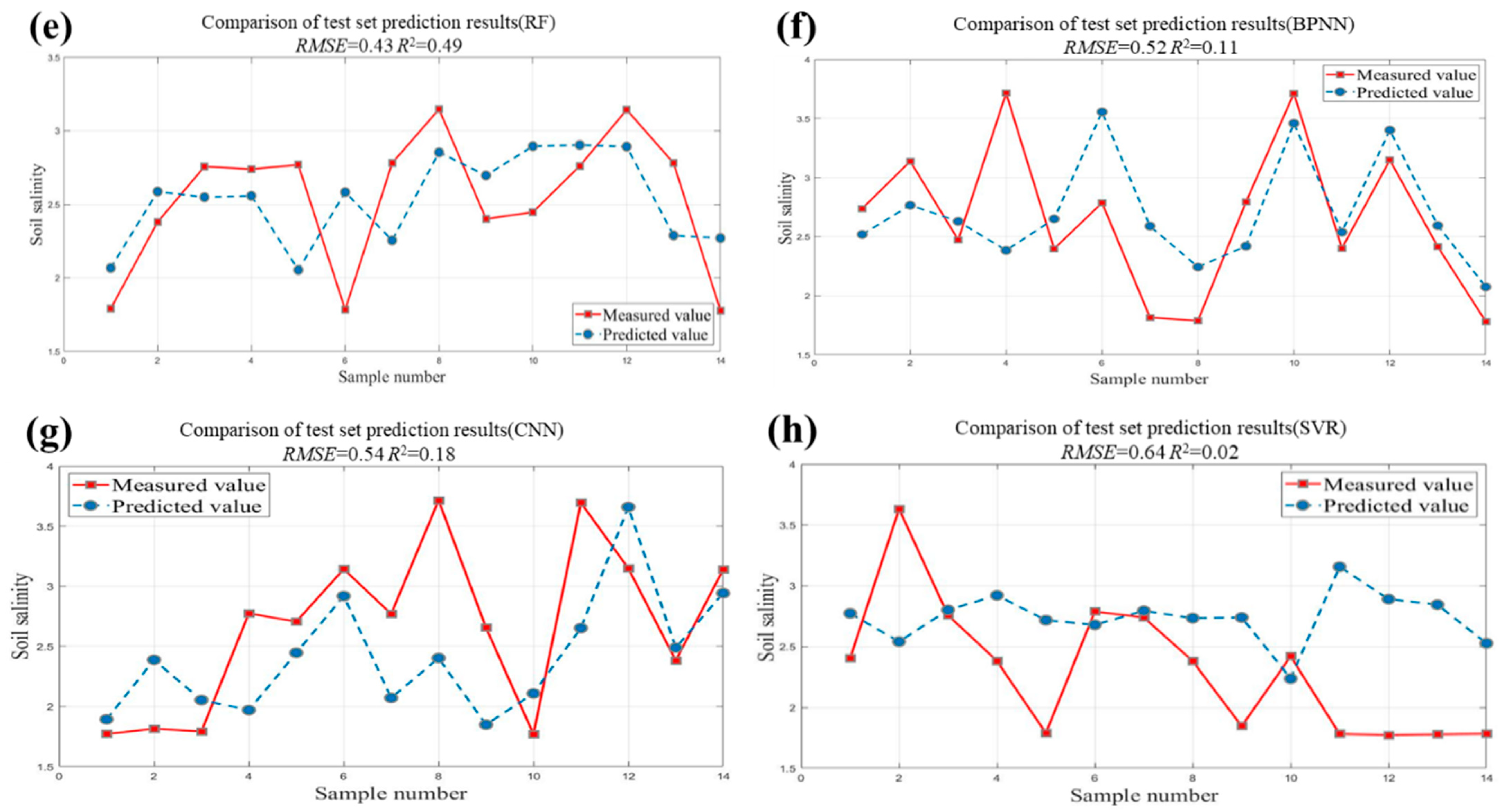
3.2. Evaluation of Machine Learning Regression Models
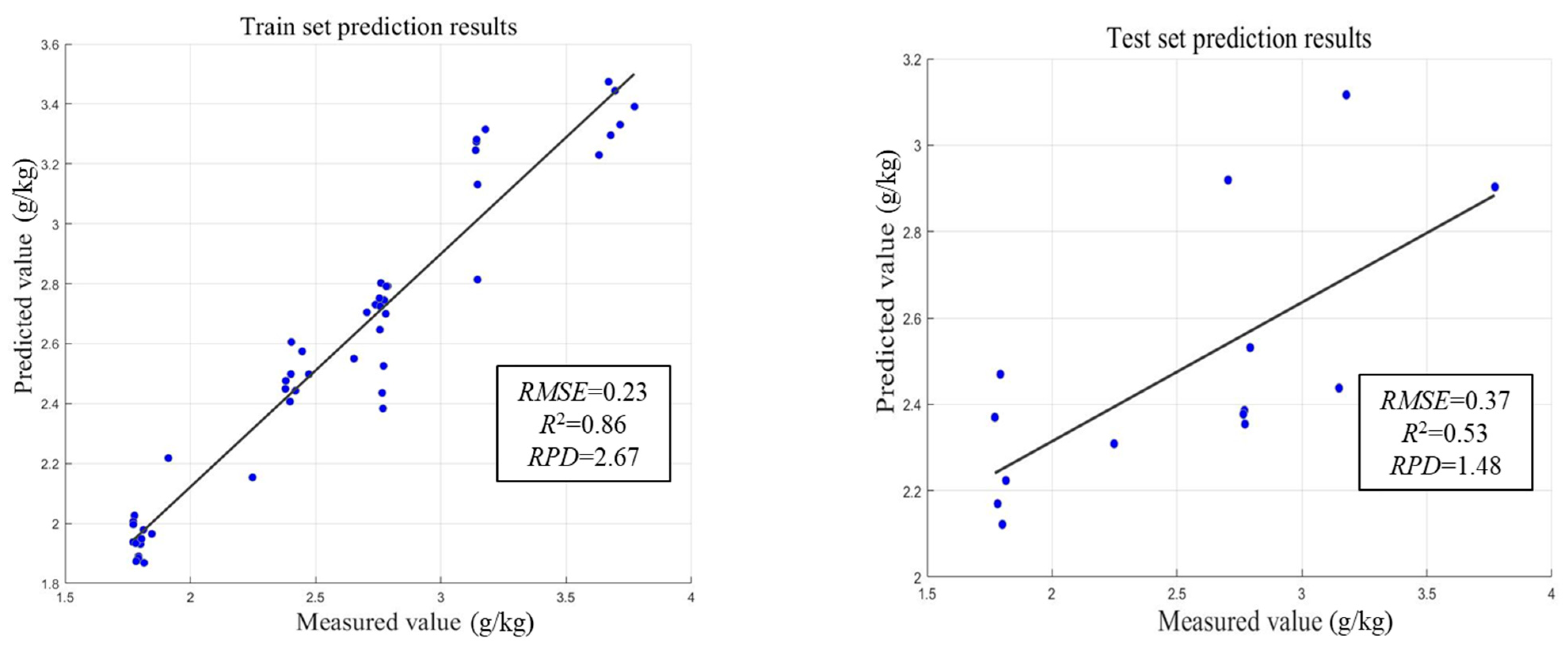
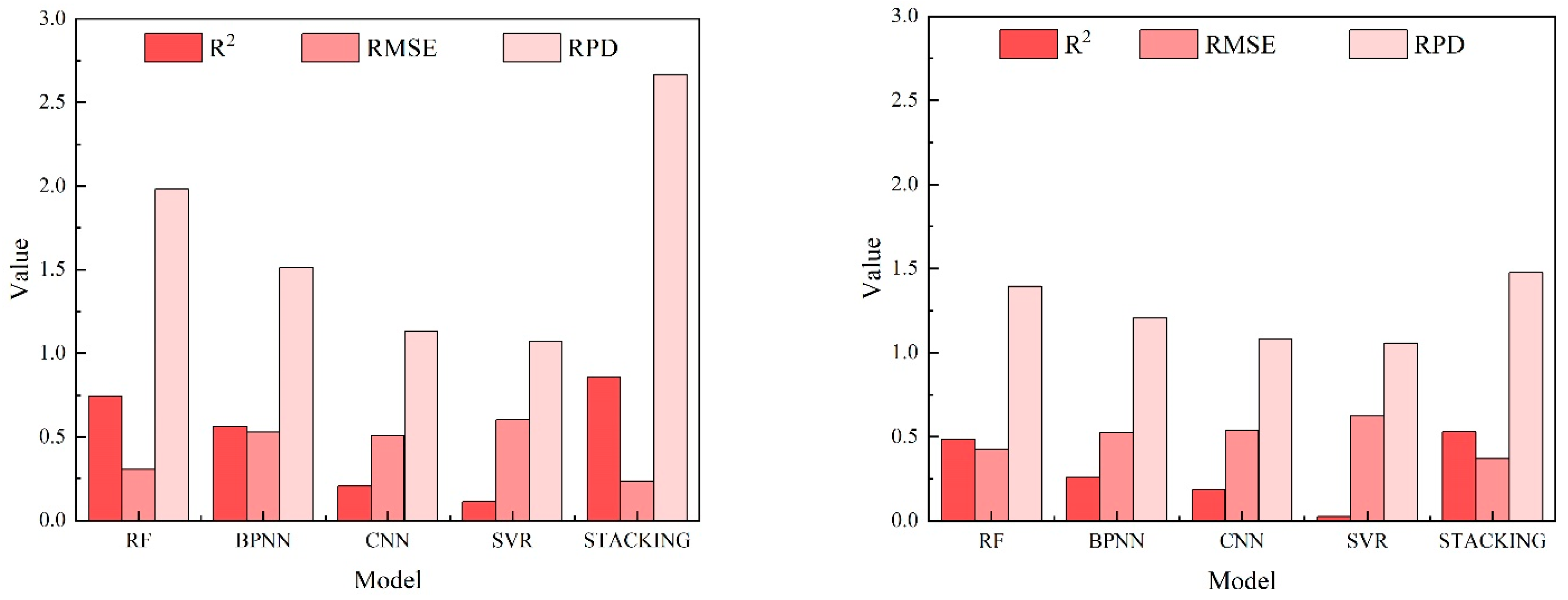
3.3. Stacking Integrated Learning Regression Model Evaluation
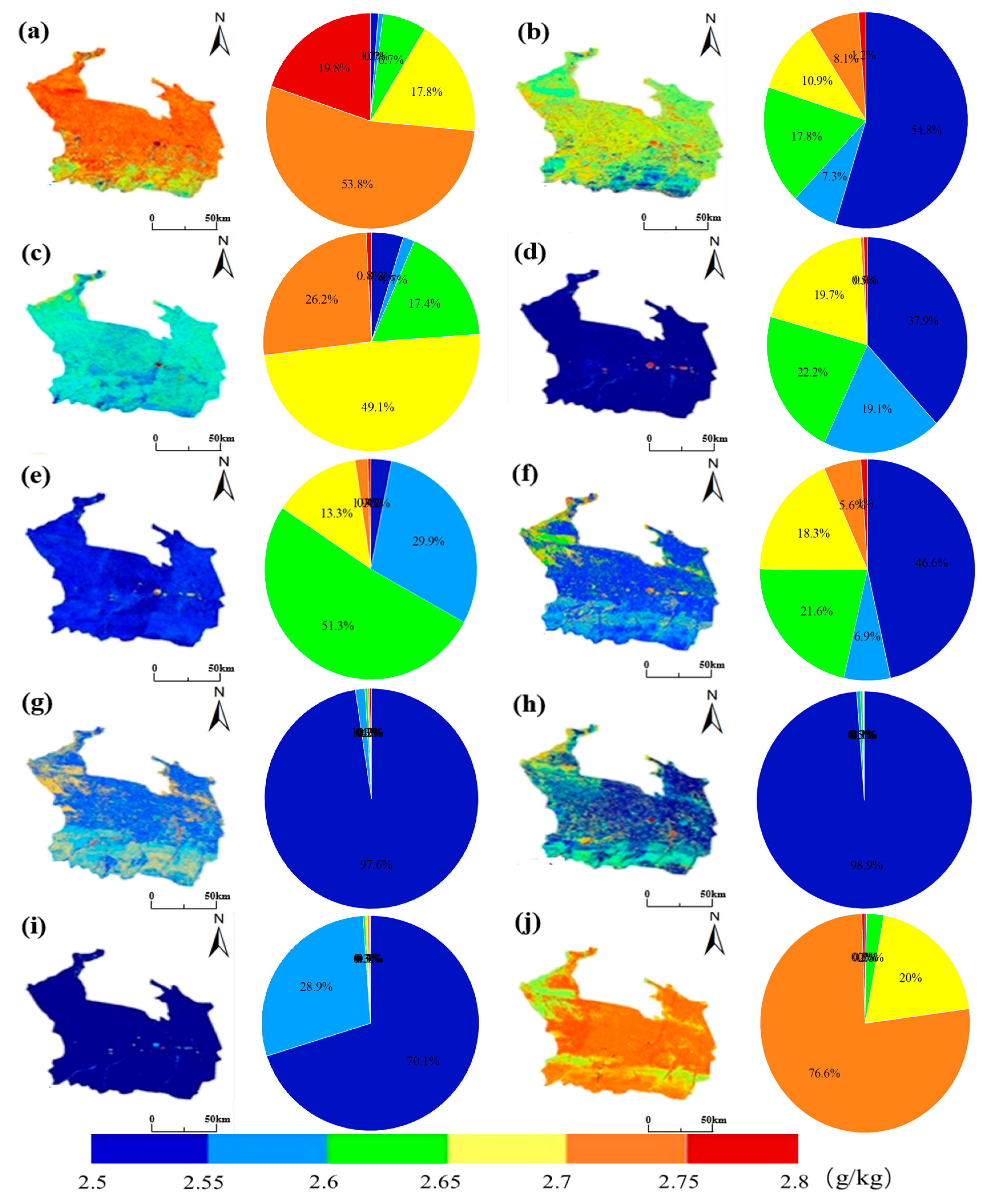
3.4. Spatiotemporal Distribution of Soil Salinity
4. Discussion
5. Conclusions
Author Contributions
Funding
Institutional Review Board Statement
Data Availability Statement
Conflicts of Interest
References
- Ivushkin, K.; Bartholomeus, H.; Bregt, A.K.; Pulatov, A.; Sousa, L.D. Global mapping of soil salinity change. Remote Sens. Environ. 2019, 231, 111260. [Google Scholar] [CrossRef]
- Allbed, A.; Kumar, L.; Aldakheel, Y.Y. Assessing soil salinity using soil salinity and vegetation indices derived from IKONOS high-spatial resolution imageries: Applications in a date palm dominated region. Geoderma 2014, 230–231, 1–8. [Google Scholar] [CrossRef]
- Metternicht, G.I.; Zinck, J.A. Remote sensing of soil salinity: Potentials and constraints. Remote Sens. Environ. 2003, 85, 1–20. [Google Scholar] [CrossRef]
- Zhao, W.; Zhou, C.; Zhou, C.; Ma, H.; Wang, Z. Soil Salinity Inversion Model of Oasis in Arid Area Based on UAV Multispectral Remote Sensing. Remote Sens. 2022, 14, 1804. [Google Scholar] [CrossRef]
- Peng, J.; Biswas, A.; Jiang, Q.; Zhao, R.; Hu, J.; Hu, B.; Shi, Z. Estimating soil salinity from remote sensing and terrain data in southern Xinjiang Province, China. Geoderma 2019, 337, 1309–1319. [Google Scholar] [CrossRef]
- Wang, Z.; Zhang, X.; Zhang, F.; Weng, N.; Liu, S.; Deng, L. Estimation of soil salt content using machine learning techniques based on remote-sensing fractional derivatives, a case study in the Ebinur Lake Wetland National Nature Reserve, Northwest China. Ecol. Indic. 2020, 119, 106869. [Google Scholar] [CrossRef]
- Wang, S.; Chen, Y.; Wang, M.; Zhao, Y.; Li, J. SPA-Based Methods for the Quantitative Estimation of the Soil Salt Content in Saline-Alkali Land from Field Spectroscopy Data: A Case Study from the Yellow River Irrigation Regions. Remote Sens. 2019, 11, 967. [Google Scholar] [CrossRef]
- Ding, Y.; Zhang, J. Estimation of SPAD value in tomato leaves by multispectral images. J. Phys. Conf. Ser. 2020, 1634, 012128. [Google Scholar] [CrossRef]
- Zheng, M.; Bai, Y.; Zhang, J.; Ding, B.; Xiao, J. Characterization of soil salinity in typical oasis soils in arid zones based on principal component analysis--taking the 31st regiment of the second division of Xinjiang as an example Shan. Chin. Agron. Bull. 2020, 36, 81–87. [Google Scholar]
- Li, W.; Wang, Z.; Zhang, J.; Zong, R. Soil salinity variations and cotton growth under long-term mulched drip irrigation in saline alkali land of arid oasis. Irrig. Sci. 2022, 40, 103–113. [Google Scholar] [CrossRef]
- Narjary, B.; Meena, M.D.; Kumar, S.; Kamra, S.K.; Sharma, D.K.; Triantafilis, J. Digital mapping of soil salinity at various depths using an EM38. Soil Use Manag. 2018, 35, 232–244. [Google Scholar] [CrossRef]
- Csillag, F.; Pásztor, L.; Biehl, L.L. Spectral band selection for the charac-terization of salinity status of soils. Remote Sens. Environ. 1993, 43, 231–242. [Google Scholar] [CrossRef]
- Eldeiry, A.A.; Garcia, L.A. Detecting Soil Salinity in Alfalfa Fields using Spatial Modeling and Remote Sensing. Soil Sci. Soc. Am. J. 2008, 72, 201–211. [Google Scholar] [CrossRef]
- Kalra, N.K.; Joshi, D.C. Potentiality of Landsat, SPOT and IRS satellite imagery, for recognition of salt affected soils in Indian Arid Zone. Int. J. Remote Sens. 1996, 17, 3001–3014. [Google Scholar] [CrossRef]
- Ding, J.; Yu, D. Monitoring and evaluating spatial variability of soil salinity in dry and wet seasons in the Werigan–Kuqa Oasis, China, using remote sensing and electromagnetic induction instruments. Geoderma 2014, 235–236, 316–322. [Google Scholar] [CrossRef]
- Ma, Y.; Chen, H.; Zhao, G.; Wang, Z.; Wang, D. Spectral Index Fusion for Salinized Soil Salinity Inversion Using Sentinel-2A and UAV Images in a Coastal Area. IEEE Access 2020, 8, 159595–159608. [Google Scholar] [CrossRef]
- Bannari, A.; El-Battay, A.; Bannari, R.; Rhinane, H. Sentinel-MSI VNIR and SWIR Bands Sensitivity Analysis for Soil Salinity Discrimination in an Arid Landscape. Remote Sens. 2018, 10, 855. [Google Scholar] [CrossRef]
- Dehni, A.; Lounis, M. Remote Sensing Techniques for Salt Affected Soil Mapping: Application to the Oran Region of Algeria. Procedia Eng. 2012, 33, 188–198. [Google Scholar] [CrossRef]
- Aldabaa, A.A.A.; Weindorf, D.C.; Chakraborty, S.; Sharma, A.; Li, B. Combination of proximal and remote sensing methods for rapid soil salinity quantification. Geoderma 2015, 239–240, 34–46. [Google Scholar] [CrossRef]
- Li, Y.; Wang, C.; Wright, A.; Liu, H.; Zhang, H.; Zong, Y. Combination of GF-2 high spatial resolution imagery and land surface factors for predicting soil salinity of muddy coasts. CATENA 2021, 202, 105304. [Google Scholar] [CrossRef]
- Xu, Y.; Smith, S.E.; Grunwald, S.; Abd-Elrahman, A.; Wani, S.P.; Nair, V.D. Estimating soil total nitrogen in smallholder farm settings using remote sensing spectral indices and regression kriging. CATENA 2018, 163, 111–122. [Google Scholar] [CrossRef]
- An, D.; Zhao, G.; Chang, C.; Wang, Z.; Li, P.; Zhang, T.; Jia, J. Hyperspectral field estimation and remote-sensing inversion of salt content in coastal saline soils of the Yellow River Delta. Int. J. Remote Sens. 2016, 37, 455–470. [Google Scholar] [CrossRef]
- Qiu, Y.; Chen, C.; Han, J.; Wang, X.; Wei, S.; Zhang, Z. Satellite remote sensing estimation modeling of soil salinity in the irrigation domain of Jiefangzha under vegetation cover conditions. Water Sav. Irrig. 2019, 10, 108–112. [Google Scholar]
- Wu, C.; Liu, G.; Huang, C. Prediction of soil salinity in the Yellow River Delta using geographically weighted regression. Arch. Agron. Soil Sci. 2017, 63, 928–941. [Google Scholar] [CrossRef]
- Lin, C.Y.; Lin, C. Using Ridge Regression Method to Reduce Estimation Uncertainty in Chlorophyll Models Based on Worldview Multispectral Data. In Proceedings of the IGARSS 2019—2019 IEEE International Geoscience and Remote Sensing Symposium, Yokohama, Japan, 28 July–2 August 2019; pp. 1777–1780. [Google Scholar]
- Wu, L.; Peng, Y.; Fan, J.; Wang, Y.; Huang, G. A novel kernel extreme learning machine model coupled with K-means clustering and firefly algorithm for estimating monthly reference evapotran-spiration in parallel computation. Agric. Water Manag. 2021, 245, 106624. [Google Scholar] [CrossRef]
- Xiao, C.; Ji, Q.; Chen, J.; Zhang, F.; Li, Y.; Fan, J.; Wang, H. Prediction of soil salinity parameters using machine learning models in an arid region of northwest China. Comput. Electron. Agric. 2023, 204, 107512. [Google Scholar] [CrossRef]
- Adab, H.; Morbidelli, R.; Saltalippi, C.; Moradian, M.; Ghalhari, G.A.F. Machine Learning to Estimate Surface Soil Moisture from Remote Sensing Data. Water 2020, 12, 3223. [Google Scholar] [CrossRef]
- Tang, S.F.; Tian, Q.J.; Xu, K.J.; Xu, N.X.; Yue, J.B. Inversion of larch forest age information by Sentinel-2 satellite. J. Remote Sens. 2020, 24, 1511–1524. [Google Scholar]
- Christensen, S.W. Ensemble Construction via Designed Output Distortion. In Multiple Classifier Systems; Windeatt, T., Roli, F., Eds.; Springer: Berlin/Heidelberg, Germany, 2003; pp. 286–295. [Google Scholar]
- Ghosh, S.M.; Behera, M.D.; Jagadish, B.; Das, A.K.; Mishra, D.R. A novel approach for estimation of aboveground biomass of a carbon-rich mangrove site in India. J. Environ. Manag. 2021, 292, 112816. [Google Scholar] [CrossRef]
- Dietterich, T.G. Ensemble Methods in Machine Learning. In Multiple Classifier Systems; Springer: Berlin/Heidelberg, Germany, 2000; pp. 1–15. [Google Scholar]
- Tao, S.; Zhang, X.; Feng, R.; Qi, W.; Wang, Y.; Shrestha, B. Retrieving soil moisture from grape growing areas using multi-feature and stacking-based ensemble learning modeling. Comput. Electron. Agric. 2023, 204, 107537. [Google Scholar] [CrossRef]
- Qi, J.; Zhang, X.; McCarty, G.W.; Sadeghi, A.M.; Cosh, M.H.; Zeng, X.; Arnold, J.G. Assessing the performance of a physically-based soil moisture module integrated within the Soil and Water Assessment Tool. Environ. Model. Softw. 2018, 109, 329–341. [Google Scholar] [CrossRef]
- Wang, S.; Wu, Y.; Li, R.; Wang, X. Remote sensing-based retrieval of soil moisture content using stacking ensemble learning models. Land Degrad. Dev. 2023, 34, 911–925. [Google Scholar] [CrossRef]
- Yang, X.H.; Luo, Y.Q.; Yang, H.C.; Lei, J.J. Inversion and spatial distribution characteristics of soil salinity in oasis farmland in Manas River basin. Arid Zone Resour. Environ. 2021, 35, 156–161. [Google Scholar]
- Zhang, L. Study on Salinized Land Use Change and Utilization Potential in Oasis-Desert Area of Manas River Basin. Ph.D. Thesis, Xinjiang Agricultural University, Urumqi, China, 2013. [Google Scholar]
- Gu, G.A. Formation of salinized soil and its prevention and control in Xinjiang. Xinjiang Geogr. 1984, 4, 1–16. [Google Scholar]
- Yang, H.C.; Zhang, F.H.; Wang, D.F.; Shao, J.R. Trends of evapotranspiration from oases in the Mahe River Basin over the past 60 years and analysis of their influencing factors. Arid Zone Resour. Environ. 2014, 28, 18–23. [Google Scholar]
- Xin, M.L.; Lv, T.B.; He, X.L.; Cao, Y.B.; Wang, M.M. Spatial analysis of soil salinity in Manas River irrigation area based on ROC curve. J. Irrig. Drain. 2016, 35, 45–50. [Google Scholar]
- Tian, F.; Fensholt, R.; Verbesselt, J.; Grogan, K.; Horion, S.; Wang, Y. Evaluating temporal consistency of long-term global NDVI datasets for trend analysis. Remote Sens. Environ. 2015, 163, 326–340. [Google Scholar] [CrossRef]
- Forkel, M.; Carvalhais, N.; Verbesselt, J.; Mahecha, M.D.; Neigh, C.S.; Reichstein, M. Trend Change Detection in NDVI Time Series: Effects of Inter-Annual Variability and Methodology. Remote Sens. 2013, 5, 2113–2144. [Google Scholar] [CrossRef]
- Vaudour, E.; Gomez, C.; Lagacherie, P.; Loiseau, T.; Baghdadi, N.; Urbina-Salazar, D.; Loubet, B.; Arrouays, D. Temporal mosaicking approaches of Sentinel-2 images for extending topsoil organic carbon content mapping in croplands. Int. J. Appl. Earth Obs. Geoinf. 2021, 96, 102277. [Google Scholar] [CrossRef]
- Shrestha, R.P. Relating soil electrical conductivity to remote sensing and other soil properties for assessing soil salinity in northeast Thailand. Land Degrad. Dev. 2006, 17, 677–689. [Google Scholar] [CrossRef]
- Alhammadi, M.S.; Glenn, E.P. Detecting date palm trees health and vegetation greenness change on the eastern coast of the United Arab Emirates using SAVI. Int. J. Remote Sens. 2008, 29, 1745–1765. [Google Scholar] [CrossRef]
- Yao, Y.; Ding, J.L.; Zhang, F.; Zhao, Z.; Jiang, H. Regional soil salinization monitoring model based on hyperspectral index and electromagnetic induction. Spectrosc. Spectr. Anal. 2013, 33, 1658–1664. [Google Scholar]
- Douaoui, A.E.K.; Nicolas, H.; Walter, C. Detecting salinity hazards within a semiarid context by means of combining soil and remote-sensing data. Geoderma 2006, 134, 217–230. [Google Scholar] [CrossRef]
- Abbas, A.; Khan, S.; Hussain, N.; Hanjra, M.A.; Akbar, S. Characterizing soil salinity in irrigated agriculture using a remote sensing approach. Phys. Chem. Earth 2013, 55–57, 43–52. [Google Scholar] [CrossRef]
- Khan, N.M.; Rastoskuev, V.V.; Shalina, E.V.; Sato, Y. Mapping Salt-affected Soils Using Remote Sensing Indicators—A Simple Approach with the Use of GIS IDRISI. In Proceedings of the 22nd Asian Conference on Remote Sensing, Singapore, 5–9 November 2001. [Google Scholar]
- Liu, H.J.; Yang, H.X.; Xu, M.Y. Soil classification based on multi-temporal remote sensing image features and maximum likelihood method during bare soil period. J. Agric. Eng. 2018, 34, 132–139+304. [Google Scholar]
- Fu, B.L.; Deng, L.C.; Zhang, L.; Tan, J.; Liu, M.; Jia, M.; He, H.; Deng, T.; Gao, E.; Fan, D. Remote sensing inversion of chlorophyll content in mangrove canopy with combined on-board hyperspectral imagery and stacked integrated learning regression algorithm. J. Remote Sens. 2022, 26, 1182–1205. [Google Scholar]
- Zhang, F.; Li, X.; Zhou, X.; Chan, N.W.; Tan, M.L.; Kung, H.T.; Shi, J. Retrieval of soil salinity based on multi-source remote sensing data and differential transformation technology. Int. J. Remote Sens. 2023, 44, 1348–1368. [Google Scholar] [CrossRef]
- Zhang, Z.T.; Tai, X.; Yang, N.; Zhang, J.; Huang, X.; Chen, Q. Inversion of soil salinity by unmanned aerial vehicle multispectral remote sensing under different vegetation cover. J. Agric. Mach. 2022, 53, 220–230. [Google Scholar]
- Hu, J.; Lv, Y.H. Progress in stochastic modeling of soil moisture dynamics. Prog. Geosci. 2015, 34, 389–400. [Google Scholar]
- Chen, H.Y.; Zhao, G.X.; Chen, J.C.; Ruiyan, W.; Mingxiu, G. Remote sensing inversion of saline soil salinity based on modified vegetation index in estuary area of Yellow River. J. Agric. Eng. 2015, 31, 107–114. [Google Scholar]
- Tang, X.L.; Lv, X. Impacts of climate change on available precipitation in the Manas River Basin over the past 50 years. Hubei Agric. Sci. 2011, 50, 4582–4585. [Google Scholar]
- Wei, G.; Li, Y.; Zhang, Z.; Chen, Y.; Chen, J.; Yao, Z.; Lao, C.; Chen, H. Estimation of soil salt content by combining UAV-borne multispectral sensor and machine learning algorithms. PeerJ 2020, 8, e9087. [Google Scholar] [CrossRef] [PubMed]
- Zhang, Z.T.; Wei, G.F.; Yao, Z.H.; Tan, C.X.; Wang, X.T.; Han, J. Research on soil salinity inversion modeling based on multi-spectral remote sensing by unmanned aircraft. J. Agric. Mach. 2019, 50, 151–160. [Google Scholar]
- Yang, H.; Hu, Y.; Zheng, Z.; Qiao, Y.; Zhang, K.; Guo, T.; Chen, J. Estimation of Potato Chlorophyll Content from UAV Multispectral Images with Stacking Ensemble Algorithm. Agronomy 2022, 12, 2318. [Google Scholar] [CrossRef]
- Pham, K.; Won, J. Enhancing the tree-boosting-based pedotransfer function for saturated hydraulic conductivity using data preprocessing and predictor importance using game theory. Geoderma 2022, 420, 115864. [Google Scholar] [CrossRef]
- Obsie, E.Y.; Qu, H.; Drummond, F. Wild blueberry yield prediction using a combination of computer simulation and machine learning algorithms. Comput. Electron. Agric. 2020, 178, 105778. [Google Scholar] [CrossRef]
- Li, W.D.; Shi, X.Y.; Song, J.H.; Tian, T.; Wang, H.J. Analysis of the dominant factors of soil physicochemical properties and salt ion composition in different geomorphic types of Manas River Basin. J. Shihezi Univ. (Nat. Sci. Ed.) 2022, 40, 75–83. [Google Scholar]
- Zhang, F.H.; Zhao, Q.; Pan, X.D.; Li, Y.Y. Spatial differentiation of soil properties and rational development model of oasis in Mahe Basin, Xinjiang. J. Soil Water Conserv. 2005, 6, 55–58. [Google Scholar]
- Xia, J.; Wang, S.M.; Zhu, H.W.; Cao, G.D.; Liu, B. Spatial variability of soil salinity in the middle and lower reaches of the Manas River basin. Xinjiang Agric. Sci. 2012, 49, 542–548. [Google Scholar]
- Yan, A.; Jiang, P.; Sheng, J.; Wang, X.; Wang, Z. Characterization of spatial variability of surface soil salinity in the Manas River Basin. J. Soil Sci. 2014, 51, 410–414. [Google Scholar]
- Chen, J.H.; Wang, S.M.; Cao, G.D.; Xia, J.; Zhu, H.W.; Jiang, Y.C.; Zhang, X. Physical properties of soils under different landforms and vegetation types in the Manas River Basin. Xinjiang Agric. Sci. 2012, 49, 354–361. [Google Scholar]
- Zhao, Y.C.; HuDan, T.M.E.B.; MaHeHuJiang, A.H.M.T.; Zhu, D.Q.; Li, H.; Zhu, H.Q. Characterization of intra- and inter-annual soil salinity changes in perennial drip-irrigated cotton fields in Northern Xinjiang. Res. Arid. Reg. Agric. 2015, 33, 130–134. [Google Scholar]


| Type of Index | Spectral Index | Abbrev | Formulas | Reference |
|---|---|---|---|---|
| Vegetation spectral indices (VIs) | Normalized Difference Vegetation Index | NDVI | Shrestha et al. 2006 [44] | |
| Difference Vegetation Index | DVI | Shrestha et al. 2006 [44] | ||
| Soil-Adjusted Vegetation Index | SAVI | Alhammadi et al. 2008 [45] | ||
| Ratio Vegetation Index | RVI | Alhammadi et al. 2008 [45] | ||
| Green Normalized Difference Vegetation Index | GNDVI | Bannari et al. 2018 [17] | ||
| Salinity spectral indices (SIs) | Salinity Index | SI | Yao Y et al. 2013 [46] | |
| Salinity Index 1 | SI1 | Allbed et al. 2014 [2] | ||
| Salinity Index 2 | SI2 | Douaoui et al. 2005 [47] | ||
| Salinity Index 3 | SI3 | Douaoui et al. 2005 [47] | ||
| Salinity Index 7 | SI7 | Abbas et al. 2013 [48] | ||
| Normalized Difference Salinity Index | NDSI | Khan et al. 2001 [49] | ||
| Soil Salinity Remote Sensing index | SRSI | Alhammadi et al. 2008 [45] | ||
| NDWI | Normalized Difference Water Index | NDWI | Liu H J et al. 2018 [50] | |
| BI | Brightness Index | BI | Khan et al. 2001 [49] |
| Model | Train Set | Test Set | ||||
|---|---|---|---|---|---|---|
| R2 | RMSE | RPD | R2 | RMSE | RPD | |
| RF | 0.74 | 0.30 | 1.98 | 0.49 | 0.43 | 1.39 |
| BPNN | 0.56 | 0.53 | 1.51 | 0.26 | 0.52 | 1.21 |
| CNN | 0.20 | 0.51 | 1.13 | 0.18 | 0.54 | 1.08 |
| SVR | 0.11 | 0.60 | 1.07 | 0.02 | 0.62 | 1.06 |
Disclaimer/Publisher’s Note: The statements, opinions and data contained in all publications are solely those of the individual author(s) and contributor(s) and not of MDPI and/or the editor(s). MDPI and/or the editor(s) disclaim responsibility for any injury to people or property resulting from any ideas, methods, instructions or products referred to in the content. |
© 2024 by the authors. Licensee MDPI, Basel, Switzerland. This article is an open access article distributed under the terms and conditions of the Creative Commons Attribution (CC BY) license (https://creativecommons.org/licenses/by/4.0/).
Share and Cite
Dong, H.; Tian, F. Soil Salinity Inversion Based on a Stacking Integrated Learning Algorithm. Agriculture 2024, 14, 1777. https://doi.org/10.3390/agriculture14101777
Dong H, Tian F. Soil Salinity Inversion Based on a Stacking Integrated Learning Algorithm. Agriculture. 2024; 14(10):1777. https://doi.org/10.3390/agriculture14101777
Chicago/Turabian StyleDong, Haili, and Fei Tian. 2024. "Soil Salinity Inversion Based on a Stacking Integrated Learning Algorithm" Agriculture 14, no. 10: 1777. https://doi.org/10.3390/agriculture14101777
APA StyleDong, H., & Tian, F. (2024). Soil Salinity Inversion Based on a Stacking Integrated Learning Algorithm. Agriculture, 14(10), 1777. https://doi.org/10.3390/agriculture14101777