
Comparison of Methods for Estimating Damage by Wild Ungulates on Field Crops

 ,
,  ,
,
Abstract
1. Introduction
2. Materials and Methods
2.1. Study Area
2.2. Ground-Based Assessment
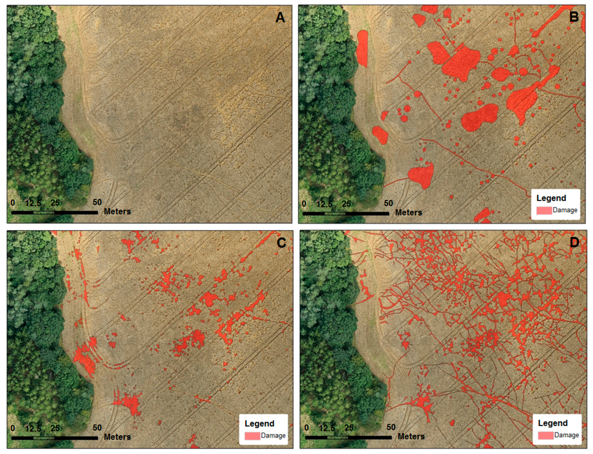
2.3. UAS Crop Height Method
2.4. UAS with Operator Delineation Method
2.5. Yield Method
2.6. Data Analysis
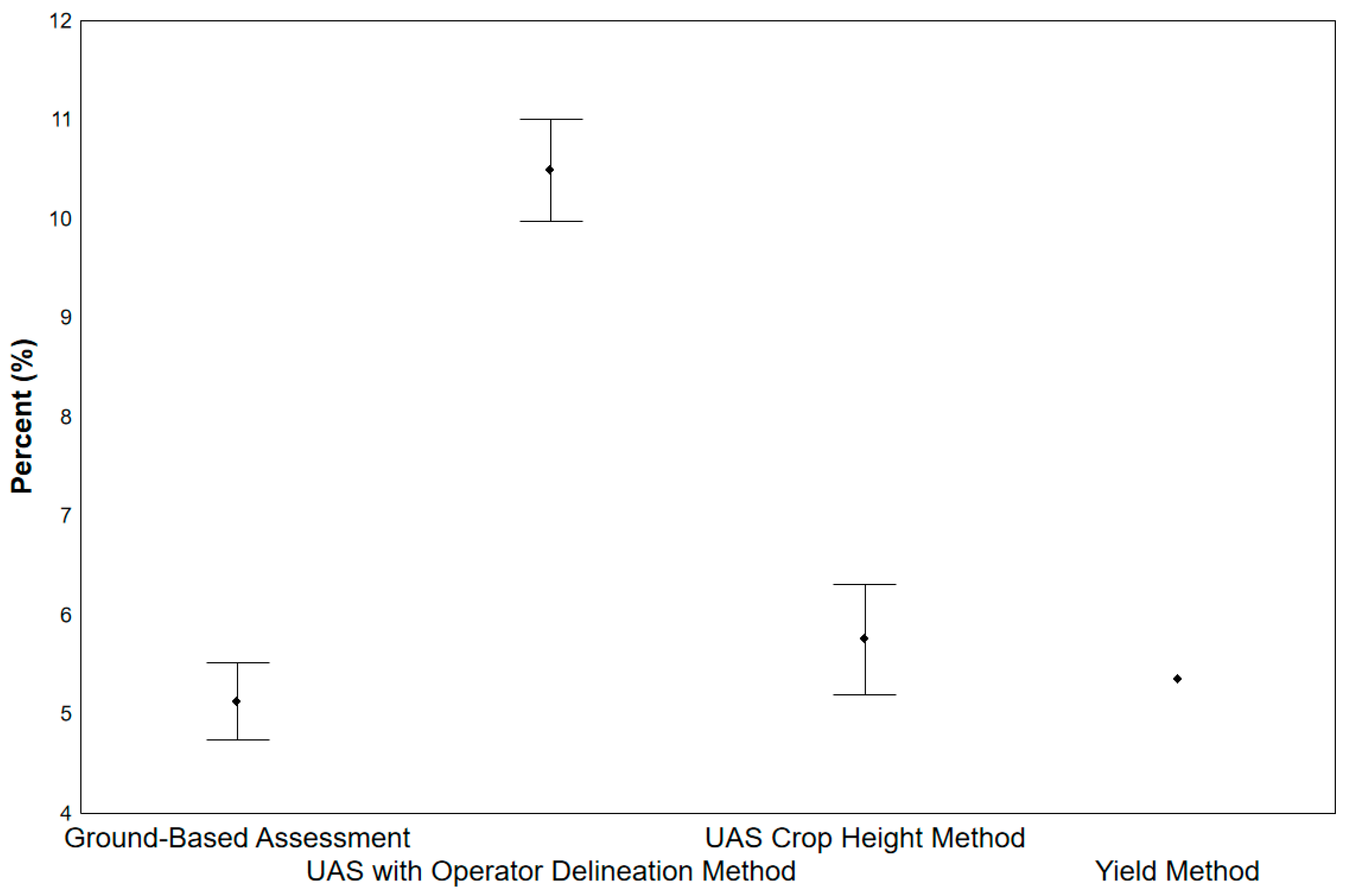
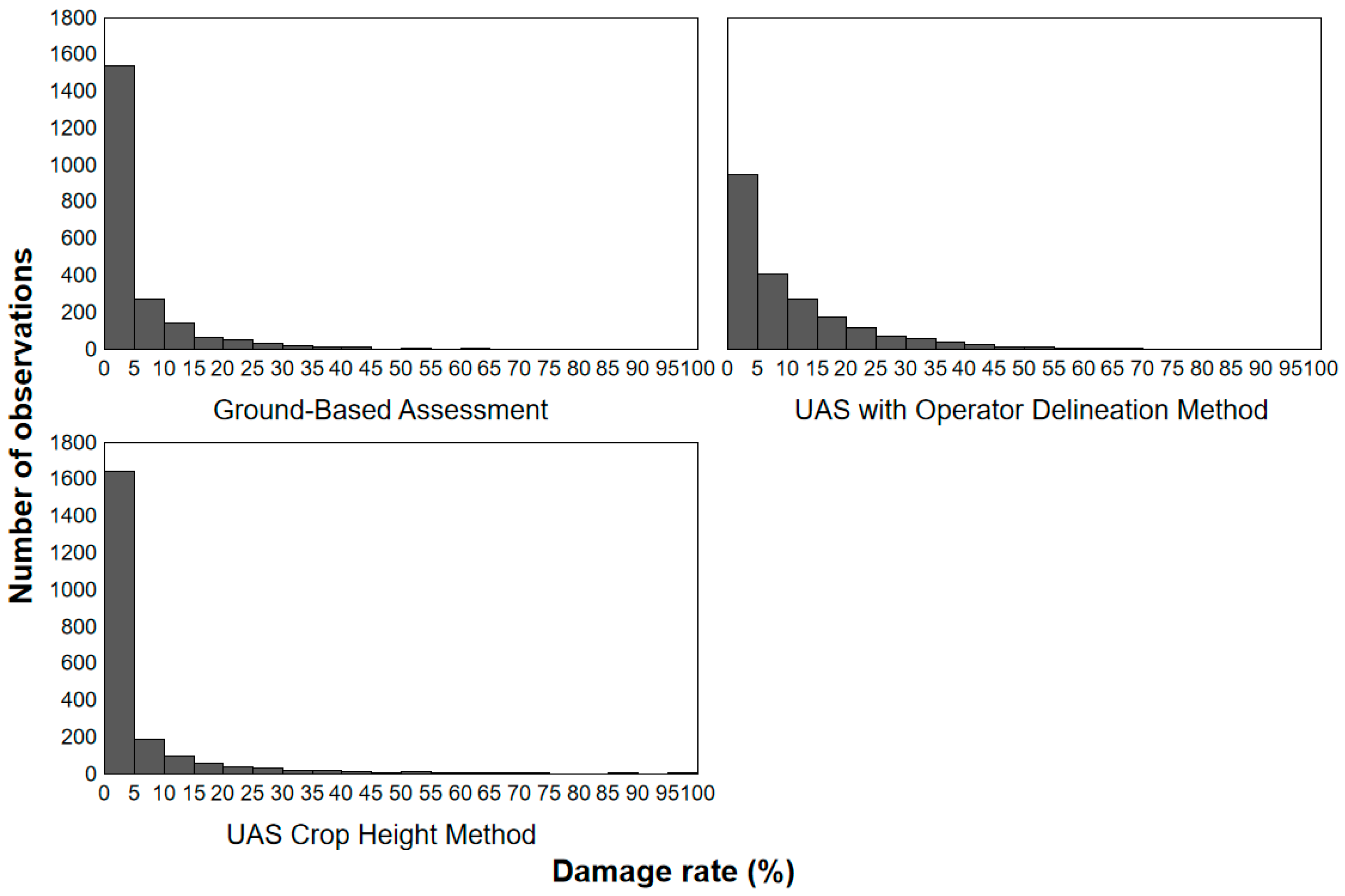
3. Results
4. Discussion
4.1. Comparison of Method Results
4.2. Economic Evaluation of the Methods
4.3. Management Implications
5. Conclusions
Author Contributions
Funding
Institutional Review Board Statement
Data Availability Statement
Acknowledgments
Conflicts of Interest
References
- Herruzo, A.C.; Martínez-Jauregui, M. Trends in hunters, hunting grounds and big game harvest in Spain. For. Syst. 2013, 22, 114–122. [Google Scholar] [CrossRef]
- Apollonio, M.; Belkin, V.V.; Borkowski, J.; Borodin, O.I.; Borowik, T.; Cagnacci, F.; Yanuta, G. Challenges and science-based implications for modern management and conservation of European ungulate populations. Mammal Res. 2017, 62, 209–217. [Google Scholar] [CrossRef]
- Carpio, A.J.; Apollonio, M.; Acevedo, P. Wild ungulate overabundance in Europe: Contexts, causes, monitoring and management recommendations. Mammal Rev. 2021, 51, 95–108. [Google Scholar] [CrossRef]
- Massei, G.; Kindberg, J.; Licoppe, A.; Gačić, D.; Šprem, N.; Kamler, J.; Náhlik, A. Wild boar populations up, numbers of hunters down? A review of trends and implications for Europe. Pest Manag. Sci. 2015, 71, 492–500. [Google Scholar] [CrossRef]
- Wehr, N.H. Historical range expansion and biological changes of Sus scrofa corresponding to domestication and feralization. Mammal Rev. 2021, 66, 1–12. [Google Scholar] [CrossRef]
- Bernes, C.; Macura, B.; Jonsson, B.G.; Junninen, K.; Müller, J.; Sandström, J.; Macdonald, E. Manipulating ungulate herbivory in temperate and boreal forests: Effects on vegetation and invertebrates. A systematic review. Environ. Evid. 2018, 7, 13. [Google Scholar] [CrossRef]
- Linnell, J.D.; Cretois, B.; Nilsen, E.B.; Rolandsen, C.M.; Solberg, E.J.; Veiberg, V.; Kaltenborn, B. The challenges and opportunities of coexisting with wild ungulates in the human-dominated landscapes of Europe’s Anthropocene. Biol. Conserv. 2020, 244, 108500. [Google Scholar] [CrossRef]
- Felton, A.M.; Hedwall, P.O.; Felton, A.; Widemo, F.; Wallgren, M.; Holmström, E.; Wam, H.K. Forage availability, supplementary feed and ungulate density: Associations with ungulate damage in pine production forests. For. Ecol. Manag. 2022, 513, 120187. [Google Scholar] [CrossRef]
- Kincheloe, J.M.; Horn-Delzer, A.R.; Makau, D.N.; Wells, S.J. Chronic Wasting Disease Transmission Risk Assessment for Farmed Cervids in Minnesota and Wisconsin. Viruses 2021, 13, 1586. [Google Scholar] [CrossRef]
- Mallapaty, S. COVID is spreading in deer What does that mean for the pandemic? Nature 2022, 604, 612–615. [Google Scholar] [CrossRef]
- Steiner, W.; Schöll, E.M.; Leisch, F.; Hackländer, K. Temporal patterns of roe deer traffic accidents: Effects of season, daytime and lunar phase. PLoS ONE 2021, 16, e0249082. [Google Scholar] [CrossRef] [PubMed]
- Côté, S.D.; Rooney, T.P.; Tremblay, J.P.; Dussault, C.; Waller, D.M. Ecological impacts of deer overabundance. Annu. Rev. Ecol. Evol. Syst. 2004, 35, 113–147. [Google Scholar] [CrossRef]
- Putman, R.J.; Moore, N.P. Impact of deer in lowland Britain on agriculture, forestry and conservation habitats. Mammal Rev. 1998, 28, 141–164. [Google Scholar] [CrossRef]
- Weisberg, P.J.; Bugmann, H. Forest dynamics and ungulate herbivory: From leaf to landscape. For. Ecol. Manag. 2003, 181, 1–12. [Google Scholar] [CrossRef]
- Kamler, J.; Dobrovolný, L.; Drimaj, J.; Kadavý, J.; Kneifl, M.; Adamec, Z.; Hrbek, J. The impact of seed predation and browsing on natural sessile oak regeneration under different light conditions in an over-aged coppice stand. iForest 2016, 9, 569. [Google Scholar] [CrossRef]
- Skoták, V.; Drimaj, J.; Kamler, J. Evaluation of damage to forest tree plantations by wild boar in the Czech Republic. Hum.–Wildl. Interact. 2021, 15, 13. [Google Scholar] [CrossRef]
- Kristiansson, H. Crop damage by wild boars in Central Sweden. In Proceedings of the XVIIth Congress of the International Union of Game Biologists IUGB, Brussels, Belgium, 17–21 September 1985; pp. 605–609. [Google Scholar]
- Schley, L.; Roper, T.J. Diet of wild boar Sus scrofa in Western Europe, with particular reference to consumption of agricultural crops. Mammal Rev. 2003, 33, 43–56. [Google Scholar] [CrossRef]
- Seward, N.W.; VerCauteren, K.C.; Witmer, G.W.; Engeman, R.M. Feral swine impacts on agriculture and the environment. Sheep Goat Res. J. 2004, 12, 34–40. [Google Scholar]
- Rutten, A.; Casaer, J.; Strubbe, D.; Leirs, H. Agricultural and landscape factors related to increasing wild boar agricultural damage in a highly anthropogenic landscape. Wildl. Biol. 2019, 2019, 1–11. [Google Scholar] [CrossRef]
- Spake, R.; Bellamy, C.; Gill, R.; Watts, K.; Wilson, T.; Ditchburn, B.; Eigenbrod, F. Forest damage by deer depends on cross-scale interactions between climate, deer density and landscape structure. J. Appl. Ecol. 2020, 57, 1376–1390. [Google Scholar] [CrossRef]
- Reimoser, S.; Partl, E.; Reimoser, F.; Vospernik, S. Roe-deer habitat suitability and predisposition of forest to browsing damage in its dependence on forest growth—Model sensitivity in an alpine forest region. Ecol. Model. 2009, 220, 2231–2243. [Google Scholar] [CrossRef]
- Bolibok, L.; Andrzejczyk, T.; Szeligowski, H.; Liziniewicz, M. New methods of oak planting require modification of tending prescriptions under high browsing pressure—A case study from north-eastern Poland. For. Ecol. Manag. 2021, 497, 119449. [Google Scholar] [CrossRef]
- Thurfjell, H.; Ball, J.P.; Åhlén, P.A.; Kornacher, P.; Dettki, H.; Sjöberg, K. Habitat use and spatial patterns of wild boar Sus scrofa (L.): Agricultural fields and edges. Eur. J. Wildl. Res. 2009, 55, 517–523. [Google Scholar] [CrossRef]
- Michez, A.; Morelle, K.; Lehaire, F.; Widar, J.; Authelet, M.; Vermeulen, C.; Lejeune, P. Use of unmanned aerial system to assess wildlife (Sus scrofa) damage to crops (Zea mays). J. Unmanned Veh. Syst. 2016, 4, 266–275. [Google Scholar] [CrossRef]
- Fischer, J.W.; Greiner, K.; Lutman, M.W.; Webber, B.L.; Vercauteren, K.C. Use of unmanned aircraft systems (UAS) and multispectral imagery for quantifying agricultural areas damaged by wild pigs. Crop. Prot. 2019, 125, 104865. [Google Scholar] [CrossRef]
- Rutten, A.; Casaer, J.; Vogels, M.F.; Addink, E.A.; Vanden Borre, J.; Leirs, H. Assessing agricultural damage by wild boar using drones. Wildl. Soc. Bull. 2018, 42, 568–576. [Google Scholar] [CrossRef]
- Kuželka, K.; Surový, P. Automatic detection and quantification of wild game crop damage using an unmanned aerial vehicle (UAV) equipped with an optical sensor payload: A case study in wheat. Eur. J. Remote Sens. 2018, 51, 241–250. [Google Scholar] [CrossRef]
- Samiappan, S.; Prince Czarnecki, J.M.; Foster, H.; Strickland, B.K.; Tegt, J.L.; Moorhead, R.J. Quantifying damage from wild pigs with small unmanned aerial systems. Wildl. Soc. Bull. 2018, 42, 304–309. [Google Scholar] [CrossRef]
- Roznik, M.; Boyd, M.; Porth, L. Improving crop yield estimation by applying higher resolution satellite NDVI imagery and high-resolution cropland masks. Remote Sens. Appl. Soc. Environ. 2022, 25, 100693. [Google Scholar] [CrossRef]
- Fischer, J.W.; Snow, N.P.; Wilson, B.E.; Beckerman, S.F.; Jacques, C.N.; VanNatta, E.H.; Kay, S.L.; VerCauteren, K.C. Factors and costs associated with removal of a newly established population of invasive wild pigs in Northern U.S. Sci. Rep. 2020, 10, 11528. [Google Scholar] [CrossRef]
- Skoták, V.; Kamler, J. Estimating damage caused by wild animals to crops by comparing yields. J. Cultiv. Plants 2021, 73, 9–10. [Google Scholar] [CrossRef]
- Caroti, G.; Martínez-Espejo Zaragoza, I.; Piemonte, A. Accuracy assessment in Structure from Motion 3D reconstruction from drone-born images: The influence of the data processing methods. Int. Arch. Photogramm. Remote Sens. Spat. Inf. Sci. 2015, 40, 103–109. [Google Scholar] [CrossRef]
- DJI, Spreading Wings S800 User Manual, v.1. Available online: www.dji-innovations.com (accessed on 1 June 2022).
- Fonstad, M.A.; Dietrich, J.T.; Courville, B.C.; Jensen, J.L.; Carbonneau, P.E. Topographic structure from motion: A new development in photogrammetric measurement. Earth Surf. Process. Landf. 2013, 38, 421–430. [Google Scholar] [CrossRef]
- StatSoft, Inc. STATISTICA (Data Analysis Software System); Version 12; StatSoft, Inc.: Tulsa, OK, USA, 2013; Available online: www.statsoft.com (accessed on 15 September 2022).
- Bayani, A.; Tiwade, D.; Dongre, A.; Dongre, A.P.; Phatak, R.; Watve, M. Assessment of crop damage by protected wild mammalian herbivores on the western boundary of Tadoba-Andhari Tiger Reserve (TATR), Central India. PLoS ONE 2016, 11, e0153854. [Google Scholar] [CrossRef]
- Scholes, D.R.; Paige, K.N. Plasticity in ploidy underlies plant fitness compensation to herbivore damage. Mol. Ecol. 2014, 23, 4862–4870. [Google Scholar] [CrossRef] [PubMed]
- Skoták, V.; Kamler, J.; Cerkal, R. Herbivore damage to sunflowers (Helianthus annuus L.) in the Czech Republic. Eur. J. Wildl. Res. 2022, 68, 1–6. [Google Scholar] [CrossRef]
- Thomson, V.P.; Cunningham, S.A.; Ball, M.C.; Nicotra, A.B. Compensation for herbivory by Cucumis sativus through increased photosynthetic capacity and efficiency. Oecologia 2003, 134, 167–175. [Google Scholar] [CrossRef] [PubMed]
- Řezník, T.; Pavelka, T.; Herman, L.; Lukas, V.; Širůček, P.; Leitgeb, Š.; Leitner, F. Prediction of yield productivity zones from Landsat 8 and Sentinel-2A/B and their evaluation using farm machinery measurements. Remote Sens. 2020, 12, 1917. [Google Scholar] [CrossRef]
- Gil-Docampo, M.D.L.L.; Arza-García, M.; Ortiz-Sánz, J.; Martínez-Rodriguez, S.; Marcos-Robles, J.L.; Sánchez-Sastre, L.F. Above-ground biomass estimation of arable crops using UAV-based SfM photogrammetry. Geocarto Int. 2020, 35, 687–699. [Google Scholar] [CrossRef]


| Method | Loss in Yield (%) | Loss in Yield (tons) * |
|---|---|---|
| Ground-Based Assessment | 5.13 | 5.94 |
| UAS with Operator Delineation Method | 10.49 | 12.14 |
| UUAS Crop Height Method | 5.76 | 6.67 |
| Yield Method | 5.36 | 5.89 |
| Method | Field Data Collection for the Total Area (h) | Office/Data Analysis (h) | Total Time (h) | Human Labor Costs (35 EUR per h) 1 | Technical Equipment | Know-How |
|---|---|---|---|---|---|---|
| Ground-Based Assessment | 20 | 1 | 21 | 735 | GPS device, computer | ** |
| UAS with Operator Delineation | 2 | 60 | 62 | 2170 | drone + camera, computer | ** |
| UAS Crop Height | 2 | 3 | 5 | 175 | drone + camera, computer | *** |
| Yield | 1 | 1 | 2 | 70 | appropriate harvesting machine, yield data | * |
| Drone (contractually) | - | - | - | 740 | - | - |
Disclaimer/Publisher’s Note: The statements, opinions and data contained in all publications are solely those of the individual author(s) and contributor(s) and not of MDPI and/or the editor(s). MDPI and/or the editor(s) disclaim responsibility for any injury to people or property resulting from any ideas, methods, instructions or products referred to in the content. |
© 2023 by the authors. Licensee MDPI, Basel, Switzerland. This article is an open access article distributed under the terms and conditions of the Creative Commons Attribution (CC BY) license (https://creativecommons.org/licenses/by/4.0/).
Share and Cite
Drimaj, J.; Skoták, V.; Kamler, J.; Plhal, R.; Adamec, Z.; Mikulka, O.; Janata, P. Comparison of Methods for Estimating Damage by Wild Ungulates on Field Crops. Agriculture 2023, 13, 1184. https://doi.org/10.3390/agriculture13061184
Drimaj J, Skoták V, Kamler J, Plhal R, Adamec Z, Mikulka O, Janata P. Comparison of Methods for Estimating Damage by Wild Ungulates on Field Crops. Agriculture. 2023; 13(6):1184. https://doi.org/10.3390/agriculture13061184
Chicago/Turabian StyleDrimaj, Jakub, Vlastimil Skoták, Jiří Kamler, Radim Plhal, Zdeněk Adamec, Ondřej Mikulka, and Přemysl Janata. 2023. "Comparison of Methods for Estimating Damage by Wild Ungulates on Field Crops" Agriculture 13, no. 6: 1184. https://doi.org/10.3390/agriculture13061184
APA StyleDrimaj, J., Skoták, V., Kamler, J., Plhal, R., Adamec, Z., Mikulka, O., & Janata, P. (2023). Comparison of Methods for Estimating Damage by Wild Ungulates on Field Crops. Agriculture, 13(6), 1184. https://doi.org/10.3390/agriculture13061184