Abstract
Farmland landscape fragmentation is an important problem affecting the agricultural modernization process in China. However, farmland landscape fragmentation leads to land being wasted and increases management costs, particularly in the dryland’s oasis regions. Therefore, investigating the impact of farmland landscape fragmentation on agricultural irrigation is of great significance in developing oasis agriculture. This paper used the landscape quantitative index (DIVISION), the moving window method, and gradient analysis methods to study the temporal and spatial pattern changes in farmland fragmentation in the Hotan Oasis. Additionally, the impact of fragmentation on irrigation in the oasis was elaborated upon by exploring the relationship between evapotranspiration and its components in farmland fragmentation. The results showed that the farmland area of the Hotan Oasis increased from 1546.19 km2 in 2000 to 2068.23 km2 in 2020, and farmland landscape fragmentation increased with the expansion of the Hotan Oasis. In addition, a significant relationship between farmland fragmentation and evapotranspiration and its components was evident. A lower DIVISION value corresponded to a higher ET value, a lower ETs/ETc ratio, and a higher water use efficiency. When the total farmland area is assumed to remain unchanged, the irrigation water consumption is reduced by 4.82 × 10⁸ m3 according to the size and proportion of arable land with the lowest degree of fragmentation (L1, division value of 0.46). In addition, with the increase in the proportion of farmland, the scale of oasis decreases by 2431.56 km2 for the reduction in field roads, shelterbelt, and bare land. These findings suggest that solving the problem of farmland fragmentation can effectively reduce irrigation water consumption, realize the internal expansion of the oasis through intensive land use, and relieve the pressure of the external expansion of the oasis.
1. Introduction
Farmland fragmentation is the division of agricultural land into multiple independent production plots with different shapes and sizes []. Farmland fragmentation is one of the main problems in agriculture in developing countries []. The implementation of intensive land utilization, agricultural mechanization, and rural development is a major challenge for farmland fragmentation []. Farmland fragmentation is the consequence of complex interactions between multiple driving forces, including ecological forces [], economic and population growth [], landscape protection [], urbanization [], transport infrastructures [], and climate change []. This smaller and more isolated division mode will have a negative impact on the production efficiency, production technology efficiency, and scale efficiency [,]. Farmland fragmentation also contributes to higher agricultural land use heterogeneity [] and diversity [].
Irrigated agriculture is fundamental to addressing current and future dietary needs [], because it provides 40% of the global food production using only 20% of the global agricultural land []. Therefore, the efficient utilization of water resources is of great significance to the sustainable development of irrigated agriculture, especially in arid areas. Previous studies frequently analyzed the relationship between the ownership of plots, the size and number of plots [], the distance between plots, and the spatial distribution of plots from a socioeconomic perspective [,]. These studies suggest that farmland fragmentation may affect the utilization efficiency of irrigation agricultural water resources through transportation distance. For example, in the study of the land fragmentation index for drip-irrigated field systems in the Mediterranean, Heider et al. (2018) [] showed that the high dispersion of land increases the irrigation cost of the drip irrigation system.
In addition, the study of evapotranspiration (ET) and its components is important to explain regional crop water demand and crop water consumption for the better management of agricultural water resources []. For example, Li et al. (2021) [] found that the proportion of cultivated land area has a significant negative correlation with the evapotranspiration of reference crops. At the same time, the research results of Numata et al. (2021) [] and others showed that a fragmented forest landscape with high boundary density might reduce forest ET. This could be attributed to the availability of less soil water at the edges of forests, and the reduction in vegetation transpiration offsets soil evaporation, especially under drought stress. In this context, characterizing the relationship between farmland fragmentation and agricultural irrigation water consumption has become critical in evaluating fragmentation’s comprehensive effect and formulating subsequent land management policies.
The recent empirical and theoretical literature has shown the various spatial statistics and methods used to study farmland landscape fragmentation. Since it is challenging to quantify land fragmentation, most studies use the number of plots owned by farmers or their average size to measure fragmentation. Sometimes, they combine relevant information to construct comprehensive indicators to reflect fragmentation, such as the Januszewski index or the Simpson index []. However, these indicators ignore key spatial variables, such as the spatial isolation and parcel shape of farmland, which are difficult to apply for the study of regional fragmentation at a larger spatial scale. Thus, some scholars use landscape indicators for the quantification and evaluation of cultivated land fragmentation at the regional level, such as edge density (ED), patch density (PD), division (D), etc. [].
Oases are fertile pieces of land in the context of the desert environment in arid regions and are supported by artificial or natural rivers. Oases support human settlements mainly because of their fertile land, groundwater availability, and surface runoff from neighboring mountains []. Irrigated agriculture is the main pillar of the oasis economy, and the improvement of its structure and function is of great significance to the sustainable development of oases [,]. However, the structure of oasis landscapes is gradually becoming complex due to climate change, showing various fragmentation trends []. Under arid climates, landscape fragmentation significantly impacts ET in oasis regions []. Therefore, more studies are needed to better monitor the quality and evolution trend of oasis landscapes. They could provide a reference for the scale of oasis expansion, land use/land cover change (LUCC), and the sustainable development of agriculture in arid areas with the efficient utilization of water resources. Over the past few years, several studies have analyzed the relationship between landscape fragmentation and evapotranspiration. However, few studies have revealed the relationship between oasis farmland fragmentation and crop evapotranspiration.
The Hotan Oasis is a typical oasis in an arid area, mainly due to its irrigated agriculture with complete landscape structure and function, like other oases that are located in arid areas. In view of the far-reaching impact of landscape fragmentation on oasis agriculture, this paper aims to quantify the fragmentation of arable land in the Hotan Oasis through the landscape index division. A combination of the moving window method and the gradient analysis method was used to describe the spatial and temporal pattern changes in the fragmentation of arable land in the Hotan Oasis from 2000 to 2020. On this basis, the response relationship between evapotranspiration and its components in the fragmentation of arable land has been explored to provide a scientific basis for improving the utilization of water resources in oasis irrigated agriculture and optimizing the spatial structure of arable land in arid areas.
2. Materials and Methods
2.1. Overview of the Study Area
The Hotan Oasis is located in Nanyuan, Tarim Basin. It is the largest oasis on the north slope of Kunlun Mountain, including Hotan City and Hotan, Moyu, and Luopu counties (Figure 1) [,]. The oasis is dry with little rain, strong evaporation, and windy sand. It has a continental, warm, temperate, and dry desert climate. The annual average temperature is 13 °C, the annual precipitation is less than 50 mm, the annual evaporation is 2746.30 mm, the vegetation coverage is low, and the ecosystem is relatively fragile []. The Yulong kashgar River and Kara kashgar River supply surface water for the formation and evolution of the oasis. The canal system is developed, forming a typical artificial oasis landscape []. At present, due to the large-scale development and utilization of water and soil resources in the basin, the groundwater level in the downstream area has decreased and the ecological environment is a deteriorating []. The oasis area is dominated by irrigated agriculture, with a total area of 5176.99 km2 and a cultivated land area of about 2068.23 km2 (Table 1). In addition to the water absorbed by crop roots, the rest of the agricultural water is consumed by field soil evaporation. Most of the water consumed by the oasis is dissipated by evapotranspiration, and the annual average water consumption is about 1.76 × 10⁸ m3 []. Therefore, the optimal allocation of land and the appropriate estimation of the actual evapotranspiration are of great significance in regulating the actual evapotranspiration and allocation of water resources in the oasis.
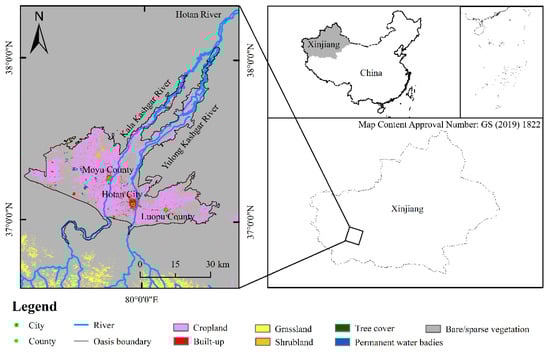
Figure 1.
Overview of the study area.

Table 1.
Transfer matrix of land use/cover area in Hotan Oasis from 2000 to 2020 (unit: km2).
2.2. Data Sources
In this study, Landsat TM remote sensing images in 2000 (resolution 30 m) and the ESA World Cover data in 2020 (resolution 10 m, resampling 30 m) were used as the basic data with ArcGIS 10.4. The software completed the geometric correction and resampling. According to the ESA land use classification standard, combined with the research content and the characteristics of the Hotan Oasis, the land use/cover types were divided into five categories: forest, grassland, farmland, others, and water. The NDVI and EVI data used to calculate evapotranspiration in the Hotan area were derived from the geospatial data cloud (http://www.gscloud.cn/, accessed on 1 January 2021). The data were Chinese products synthesized based on MODIS, with a resolution accuracy of 500 m. The meteorological data were obtained from the surface meteorological element-driven data set of China or through calculation. The grid data obtained were processed via ArcGIS 10.4 (Environmental Systems Research Institute, Redlands, California, CA, USA), and the model calculation was completed using the R version 4.3.1 (http://www.r-project.org/, accessed on 10 March 2022). Finally, the calculation results were analyzed via one-way ANOVA through Excel.
2.3. Data Analyzed
2.3.1. Calculation of Farmland Fragmentation
With the development and application of landscape ecology and GIS technology, cultivated land fragmentation can be quantitatively studied at the meso or macro level via the landscape index. The landscape division index (DIVISION, dimensionless) refers to the fragmentation level of the individual distribution of a landscape type. The larger the landscape division index, the more serious the fragmentation level of the landscape type, and the smaller the single area of the patch type, the more complex the overall landscape []. The calculation method is as follows:
where aj is the area of cultivated land patch j; n is the number of patches of landscape element type j; A is the total area of cultivated land.
Studies showed that dynamic changes in landscape patterns can affect soil hydrological processes, such as soil water evaporation, soil water content, and the stable infiltration rate of soil water. In order to explore the impact of farmland fragmentation on agricultural irrigation and explain the impact of the relationship between farmland fragmentation and evapotranspiration components on agricultural irrigation in the Hotan Oasis, we calculated the evapotranspiration and components in the Hotan area and randomly selected three low-fragmentation (L1 < L2 < L3) and three high-fragmentation (H1 < H2 < H3) areas (Figure 2) according to the calculation results of DIVISION to elaborate upon the relationship between farmland fragmentation and evapotranspiration components.
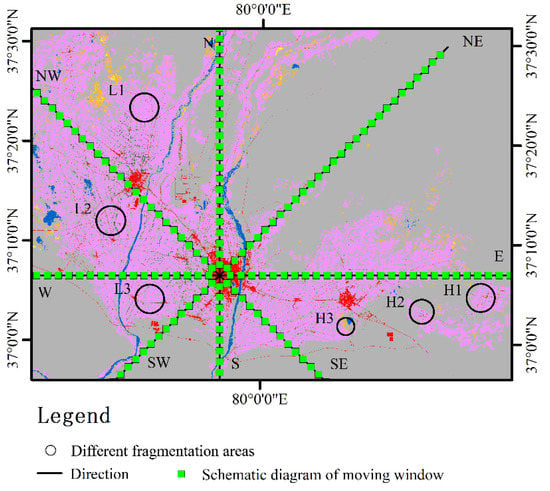
Figure 2.
Schematic diagram of gradient analysis and selection of plots with different fragments.
2.3.2. Calculation and Segmentation Method for ET
The PT-JPL model is a model proposed by Fisher and others based on the Priestley–Taylor formula and satellite remote sensing data in order to simplify the calculation of actual evapotranspiration []. The model determines the crop water demand through NDVI values. When there is no vegetation in a patch, the NDVI value is 0, and the calculated plant water demand is also 0. The PT-JPL model divides the actual evapotranspiration into three parts: canopy interception evaporation, soil evaporation, and plant transpiration, which are calculated as follows:
where ET is the total evapotranspiration (mm); ETc is the plant transpiration (mm); ETs is the soil evaporation (mm); ETi is the canopy interception evaporation (mm). The Hotan Oasis is located in an extremely arid area, with less precipitation, and the ETi in this area is very low (about 2%) in evapotranspiration. Therefore, the ETi value was ignored in the calculation and was not discussed in the study.
According to Equation (2), the PT-JPL model allows for the calculation of three parts of evapotranspiration:
where fwet is the surface relative humidity (%); Fg is the fraction of green canopy (dimensionless); fT is the vegetation temperature limit index (dimensionless); fM is the plant water restriction index (dimensionless); fSM is the limiting factor of soil water (dimensionless); α is the coefficient in the Priestley–Taylor formula; Δ is the slope of temperature-saturated water pressure (kPa/°C); γ is the dry and wet meter constant, kPa/°C; Rnc is the net radiation of the canopy (MJ/m2); Rns is the net radiation of the soil (MJ/m2); G is the soil heat flux (MJ/m2).
During the calculation of the PT-JPL model, the number of parameters involved in the calculation was reduced, so that all of the parameters could be obtained from the satellite data. Fisher et al. [] used the calculation results of the model to compare results from the monitoring of actual evapotranspiration with 16 vorticity correlators, and the correlation coefficient R2 could basically reach more than 0.9.
2.3.3. Calculation Method of Oasis Area and Irrigation Water Demand
As the regional scale of the Hotan Oasis is relatively small, it was impossible to distinguish the planting structure and planting mode; therefore, this area was studied by considering it a homogeneous area. The spatial distribution data of cultivated land were extracted from land use data, and the area and irrigation water demand of the Hotan Oasis under six scenarios with different degrees of fragmentation were calculated. The calculation formulae were as follows:
where A′ is the oasis area under a scenario simulation; A′0 is the current oasis’s cultivated land area; P is the proportion of cultivated land; W is the water demand of the oasis; ET is the total evapotranspiration of the oasis.
2.3.4. Spatial Analysis Method
The land transfer matrix comes from the quantitative description of the state transfer of the system in system analysis and is often used to describe the net change in land use, exchange change, total change, etc. In this paper, the statistics and transfer matrix calculation of different land use types in the Hotan Oasis in 2000 and 2020 were estimated through ArcGIS 10.4. As shown in Table 1, the row represents the land use type in 2020, and the column shows the land use type in 2000.
The moving window method is an effective means to analyze the spatial variation in the landscape pattern index, which can better connect the landscape pattern with natural and socio-economic processes []. However, there are few reports on its application to the change in oasis farmland landscape patterns. Referring to previous studies and the scale of the study area, mobile windows with the sizes of 0.1, 1, 2, 3, 5, and 10 km were selected for comparative analysis. After selecting the 2 km analysis window, we gradually moved it from the upper left corner of the study area, moved one grid each time, calculated the landscape index value in the window, assigned the value to the central grid of the window, and finally obtained the grid map of each landscape index. Landscape index calculation and moving window analysis were completed using Fragstats 4 software.
Gradient analysis can effectively reflect the spatial variation law of cultivated land fragmentation. Urbanization is one of the main driving factors of farmland fragmentation, and Hotan City is the largest city in the Hotan Oasis. Therefore, with the Hotan urban area (37.11214° N, 79.91353° E) as the center, a spatial moving window analysis was carried out along eight directions of four transects, East–West, South–North, North–South, Southeast–Northwest, and Northeast–Southwest, and the representative indicators were sampled equidistantly, so as to obtain the gradient difference in the cultivated land fragmentation from the city center to the periphery (Figure 2). In order to explore the relationship between agricultural development and landscape fragmentation, the study area was divided into 2 km × 2 km grid cells, the evapotranspiration of each cell was calculated, and finally, the correlation between cultivated land fragmentation and evapotranspiration data was analyzed to evaluate the relationship between them.
3. Results
3.1. Temporal and Spatial Variation Characteristics of Farmland and Its Fragmentation Degree
It can be seen from Table 1 and Figure 3 that the development of the social economy has significantly changed the vegetation coverage in the Hotan Oasis from 2000 to 2020. The farmland area has increased significantly, but the coverage area of other vegetation types has decreased. Among these, the cultivated land area increased from 1546.19 km2 in 2000 to 2068.23 km2 in 2020, showing a significant increasing trend, and the grassland area decreased from 955.91 km2 in 2000 to 6.36 km2 in 2020. Approximately 420 km2 was reclaimed as cultivated land, and the rest was mainly used for construction or classified as bare land due to serious vegetation degradation (Table 1). The water area has also been reduced by more than 50%, from 185.02 km2 in 2000 to 88.38 km2 in 2020. The forest land area changed slightly, with a reduction of only 11.38 km2 in 20 years (Table 1). After entering the 21st century, with the improvement of drilling technology, the reduction in irrigation difficulty, the support of relevant policies, and the improvement of farmers’ enthusiasm, the area of cultivated land increased, and the area of grassland decreased rapidly. In addition, the acceleration of urbanization, population growth, and urban expansion, as well as the continuous change in agricultural planting structure, have led to a continuous change in the land use pattern, and more than 1000 km2 of cultivated land has changed land use category.
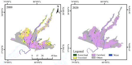
Figure 3.
Temporal and spatial changes of land use in Hotan Oasis from 2000 to 2020.
In the last 20 years, human activities have exacerbated the transformation of land use types within the oasis, and a rapid outward expansion of the oasis periphery has increased the fragmentation of the cultivated land. DIVISION is an important indicator that describes the fragmentation of cultivated land. The larger the DIVISION, the smaller the area of a single cultivated land plot and the more serious the fragmentation of cultivated land. As shown in Figure 4, the area of the Hotan Oasis increased significantly from 2000 to 2020, mainly manifested by the expansion of the oasis to desert areas. However, due to irregular and discontinuous oasis expansion, the DIVISION of the oasis edge area continues to increase. Therefore, the periphery of the oasis showed a higher fragmentation of cultivated land in 2020. Additionally, from 2000 to 2020, DIVISION’s spatial distribution was centered mainly around the river and has gradually shifted towards the oasis’ periphery. Compared with 2020, the fragmentation of cultivated land was less in 2000. The level of cultivated land fragmentation was exacerbated with the process of oasis urbanization and the adjustment of land use structure. The difference is that areas where the DIVISION decreased were also found in the west and east of the oasis, mainly because the previously existing grassland and a large area of unused land had been replaced by cultivated land, which improved the fineness of the farmland.
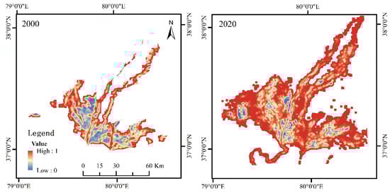
Figure 4.
Spatiotemporal distribution of farmland landscape fragmentation.
The gradient analysis of the two time periods showed that the degree of cultivated land fragmentation in 2020 was generally higher than that in 2000 (Figure 5). It can be seen from Figure 3 that the degree of farmland fragmentation on both sides of the river was low, the average area of cultivated land was high, and the degree of intensification was high. In the eight directions centered on Hotan City, the DIVISION value was not symmetrically distributed in the center of Hotan City, but in an irregular wavy distribution, with obvious fluctuations in the west–east and northwest–southeast directions. A DIVISION value of 0 indicates no cultivated land landscape in an area. Therefore, the scale of the Hotan Oasis in 2000 was smaller compared to 2020, and the land types not reclaimed by agriculture in the oasis were gradually reduced. In addition, the fragmentation degree of the newly cultivated land was generally high, indicating disparity in the process of reclamation in this area. It can be seen that the temporal and spatial changes in landscape fragmentation could reflect the expansion of the Hotan Oasis and the change in land use patterns in the last 20 years.
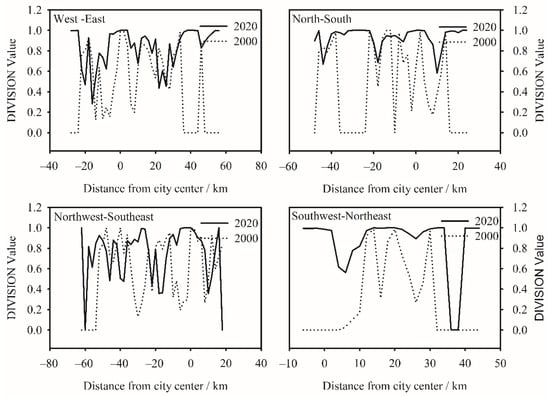
Figure 5.
The temporal gradient change in farmland fragmentation in 8 directions.
3.2. Relationship between Farmland Fragmentation and Evapotranspiration Components
In the past 20 years, the annual average evapotranspiration and its components in the Hotan Oasis remained relatively stable (Figure 6). The average values of the evapotranspiration (ET), soil evaporation (ETs), vegetation transpiration (ETc), and ETs/ETc remained 171.32 mm, 98.90 mm, 73.58 mm, and 2.02 mm in 20 years, respectively. In order to illustrate the impact of farmland fragmentation on agricultural irrigation in the Hotan Oasis, we calculated the ET, ETs, ETc, and ETs/ETc from plots with varying levels of farmland fragmentation. Figure 6a shows a comparison of the average annual evapotranspiration of different fragmentation plots. It can be seen from Figure 6a that different plots showed the same fluctuation trend of evapotranspiration, but the amount of evapotranspiration was different across different years. Overall, the average annual evapotranspiration of L1, L2, and L3 was higher than that of H1, H2, and H3. Over the last 20 years, L1 had the strongest ET with an evapotranspiration value of 578.85 mm/year; H2 had the worst ET with an evapotranspiration value of 394.84 mm/year. In addition, the evapotranspiration values of all regions reached peaks in 2004, which were 655.10 mm, 609.48 mm, 688.66 mm, 505.88 mm, 449.40 mm, and 501.46 mm. The minimum evapotranspiration values, 618.49 mm, 501.58 mm, 605.81 mm, 302.88 mm, 294.30 mm, and 385.33 mm, were noted in 2013. It can be seen that the interannual change was mainly affected by the climate, and the average annual evapotranspiration in low-fragmentation plots was higher than that in high-fragmentation plots.
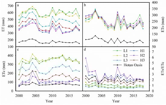
Figure 6.
Relationship between the fragmentation and ET components. Figure (a–d) describe the ET, ETs, Etc, and Ets/Etc of Hotan Oasis and different fragmentation plots from 2000 to 2018, respectively.
Figure 6b,c show a comparison of the ETs and ETc among the plots. It can be seen from the figure that different plots exhibited the same fluctuation trend of evapotranspiration components. Over the last 20 years, the ETs of all plots showed an overall decreasing trend, and the average values of soil evaporation were 290.60 mm, 285.58 mm, 268.43 mm, 300.97 mm, 304.29 mm, and 290.54 mm. The ETc showed an upward trend, with annual average values of 286.59 mm, 221.29 mm, 309.86 mm, 99.76 mm, 89.91 mm, and 152.44 mm. The ETs/ETc values among blocks showed a downward trend, with the lowest in 2013, which were 0.55, 0.69, 0.49, 1.85, 2.27, and 1.02 (Figure 6d). Overall, the ET and ETc of the L1, L2, and L3 plots were higher than those of the high-fragmentation plots (H1, H2, and H3). However, the ETs/ETc and ETs values of L1, L2, and L3 were lower as compared to the high-fragmentation plots. An analysis of variance indicated significant differences between the low- and the high-fragmentation plots, except in the case of soil evaporation (Figure 7). The results demonstrate that the degree of farmland fragmentation can affect the amount of agricultural irrigation by affecting evapotranspiration and its components in an area.
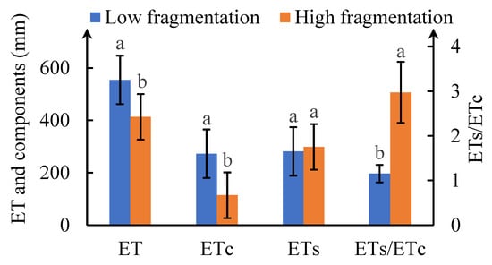
Figure 7.
Significance test of evapotranspiration and components of different fragmentation plots. Different lower-case letters at ET, ETs, ETc, and ETs/ETc indicate significant differences (p < 0.05) between the low- and the high-fragmentation plots.
3.3. Effects of the Fragmented Plots Merging on Oasis Agricultural Irrigation
Irrigated agriculture is the main component of the agricultural ecosystem in the Hotan Oasis, and the amount of farmland irrigation is one of the key factors affecting the development of water-saving agriculture in oases in arid areas. Investigating the relationship between cultivated land fragmentation and oasis agricultural irrigation is of great significance in improving the utilization efficiency of oasis agricultural water resources. Because the regional scale of the Hotan Oasis is relatively small, under the background of an inability to distinguish the planting structure and the planting mode, the region was studied as a homogeneous entity. The ETs/ETc and total oasis area of the Hotan Oasis were positively correlated with the degree of farmland fragmentation, which increased with the increase in the degree of farmland fragmentation. The total amount of ET and the total area of cultivated land showed a negative correlation, which decreased with the increase in fineness (Figure 8). Therefore, in the process of oasis expansion, when the degree of cultivated land fragmentation shows an increasing trend, the proportion of cultivated land area will gradually decrease, as will the land use efficiency. In addition, the smaller the ETs/ETc, the higher the water use efficiency of the vegetation. Therefore, the consolidation of fine plots can effectively improve the water use efficiency of farmland.
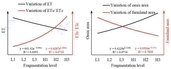
Figure 8.
Relationship between ET, ETs/ETc, oasis area, farmland area, and cultivated land fragmentation degree.
Based on the abovementioned results, the farmland of the Hotan Oasis was merged according to the proportion of cultivated land in L1, L2, and L3 with low fragmentation. Then, the ET, agricultural water resource utilization efficiency, and change in oasis scale under these three scenarios were compared with the current situation of the Hotan Oasis agriculture. After consolidating the finely divided plots and keeping the total area of arable land unchanged, the ET of the Hotan Oasis showed an increase with the decrease in farmland fragmentation (Figure 9a). Among them, the fragmentation degree of L3 was the lowest, and the ET value was the highest (about 551.42 mm). The degree of farmland fragmentation in the Hotan Oasis was the highest and the ET value was the lowest, about 386.04 mm. The results showed that a higher ET and lower ETs/ETc reflected a higher water use efficiency of crops and a higher yield. Land consolidation can effectively reduce the amount of irrigation, and the irrigation water demand decreases with the reduction in farmland fragmentation (Figure 9b). At present, the agricultural irrigation water demand of the Hotan Oasis is about 20.05 × 10⁸ m3; when the fineness degree of cultivated land is L1, the water volume is the highest, about 4.82 × 10⁸ m3. In addition, when the fineness degree of cultivated land in the Hotan Oasis is L1, the oasis scale is reduced by 2431.56 km2, and the land use efficiency is significantly improved. On the other hand, after the consolidation of finely divided plots while keeping the scale of oasis unchanged, the area of arable land will increase, and the efficiency of water resources utilization will increase. In short, the consolidation of fragmented plots is not only conducive to agricultural modernization and intensive land use, but also to improving the efficiency of agricultural irrigation water and reducing irrigation water consumption.
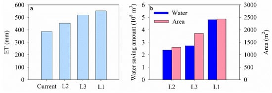
Figure 9.
Impact of consolidation of fragmented plots on Hotan irrigated agriculture. (a) Effects of different land consolidation on the ET of Hotan Oasis; (b) the water saving amount of irrigation and the scale change of Hotan Oasis after land consolidation.
4. Discussion
In the past two decades, increased urbanization and agricultural modernization have caused a significant increase in oasis and farmland areas []. The natural vegetation and ecotone periphery of the Hotan Oasis are continuously converted to cultivated land, which has resulted in a 33.76% increase in arable land. From 2000 to 2020, the evapotranspiration in the Hotan Oasis did not change much, soil evaporation decreased, the vegetation transpiration increased, and the crop water use efficiency was improved to a certain extent. As the proportion of arable land in the Hotan area has increased in recent years, changes in planting and irrigation patterns have exacerbated the microclimate effect of the oasis []. However, it is evident from the landscape science perspective that the cultivated land landscape in the Hotan Oasis is highly fragmented. It may be due to the irregular outward expansion of the oasis that the cultivated land around the oasis has maintained a high level of fragmentation since it was reclaimed []. On the other hand, human activities in the urbanization process are also the main reason for the gradual increase in farmland fragmentation in the Hotan Oasis []. Therefore, the current situation of cultivated land fragmentation in the Hotan area is not conducive to promoting agricultural modernization and intensive land use.
Existing studies have mainly focused on the impact of farmland fragmentation on land use efficiency and socio-economic benefits, and a few studies have focused on the relationship between cultivated land fragmentation and evapotranspiration []. To determine the impact of fragmentation on crop water demand/consumption, this paper used the response relationship between evapotranspiration and its components. The results showed that with the increase in fineness, the water use efficiency and ET of the cultivated land landscape decreased. In addition, the relationship between fragmentation and ET components shows that farmland fragmentation mainly affects landscape ET through the boundary density and area ratio. According to Numata et al. [], increasing edge density would increase bare soil evaporation at the edge of forest landscape patches. At the same time, the decrease in biomass and leaf area index (LAI) along the forest edge would lead to the decrease in vegetation transpiration. Unlike natural landscapes (forest land), agricultural land is affected by human activities (such as road hardening), which changes the soil evaporation. Therefore, fineness mainly affects the water use efficiency of cultivated land landscape by reducing vegetation transpiration.
Furthermore, under the assumption that the total area of farmland in the Hotan Oasis remains unchanged, this study concluded that the consolidation of fragmented land based on the plot size and proportion of L1 reduces 4.82 × 10⁸ m3 of irrigation water consumption and reduces the oasis scale by 2431.56 km2. This significant change shows that land consolidation is an effective way to tackle the fragmentation of arable landscape, improve the water use efficiency in oasis, and realize the intensive use of oasis land. Therefore, the consolidation of fragmented cultivated land can slow down the oasis external expansion process and stimulate an oasis’s internal expansion by improving the efficiency of intensive land use. When the fragmented cultivated land outside an oasis is incorporated into the oasis, the bare land and natural vegetation inside the oasis are reduced. Consequently, the resulting microclimates can reduce the oasis’s temperature, humidity, and soil evaporation [,]. In view of the relationship between farmland fragmentation and evapotranspiration, the degree of fragmentation can be used as an index for intensive land use, water-saving irrigation in oases, the appropriate scale evaluation of oases, and so on.
5. Conclusions
- (1)
- The cultivated land area of the Hotan Oasis increased from 1546.19 km2 in 2000 to 2068.23 km2 in 2020, and the fragmentation of cultivated land increased with the expansion of the Hotan Oasis.
- (2)
- There is a significant correlation between farmland fragmentation, evapotranspiration, and its components in the Hotan Oasis. The ETs/ETc and the total area of the oasis were positively correlated with farmland fragmentation, which increased with the increase in farmland fragmentation. The total amount of ET and the total area of farmland showed a negative correlation trend, which decreased with the increase in farmland fragmentation.
- (3)
- When the total area of farmland was unchanged, the consolidation effect on L1 was the best, which could save 4.82 × 10⁸ m3 of irrigation water. In addition, in the process of land consolidation, the degree of intensive utilization within the oasis was effectively improved. With the increase in farmland proportion, the scale of the oasis was decreased by 2431.56 km2, including a reduction in field roads, part of the dense shelterbelt, and bare land. Therefore, the consolidation of fragmented farmland can not only improve the utilization efficiency of agricultural water resources, but also realize the internal expansion of oases through intensive land use and alleviate the pressure of the outward expansion of oases.
Author Contributions
Conceptualization, L.Z. and D.G.; methodology, Y.L.; data curation, C.Y. and D.X.; writing—original draft preparation, L.Z.; writing—review and editing, Z.Q. and D.G.; project administration, D.G.; funding acquisition, D.G. All authors have read and agreed to the published version of the manuscript.
Funding
This research was funded by the Tianshan Innovation Team of Xinjiang (2020D14042), the National Natural Science Foundation of China (42171042), and the Special Foundation for National Science and Technology Basic Research Program of China (2019FY100205).
Data Availability Statement
The data presented in this study are available upon request from the corresponding author.
Conflicts of Interest
The authors declare no conflict of interest.
References
- Gomes, E.; Banos, A.; Abrantes, P.; Rocha, J.; Kristensen, S.B.P.; Busck, A. Agricultural land fragmentation analysis in a peri-urban context: From the past into the future. Ecol. Indic. 2019, 97, 380–388. [Google Scholar] [CrossRef]
- Jia, L.; Petrick, M. How does land fragmentation affect off-farm labor supply: Panel data evidence from China. Agric. Econ. 2014, 45, 369–380. [Google Scholar] [CrossRef]
- Haddad, N.M.; Brudvig, L.A.; Clobert, J.; Davies, K.F.; Gonzalez, A.; Holt, R.D.; Lovejoy, T.E.; Sexton, J.O.; Austin, M.P.; Collins, C.D.; et al. Habitat fragmentation and its lasting impact on Earth’s ecosystems. Sci. Adv. 2015, 1, 9. [Google Scholar] [CrossRef] [PubMed]
- Xiao, L.; Xianjin, H.; Taiyang, Z.; Yuntai, Z.; Yi, L. A Review of farmland fragmentation in China. J. Resour. Ecol. 2013, 4, 344–352. [Google Scholar] [CrossRef]
- Sklenicka, P.; Salek, M. Ownership and soil quality as sources of agricultural land fragmentation in highly fragmented ownership patterns. Landsc. Ecol. 2008, 23, 299–311. [Google Scholar] [CrossRef]
- Bürgi, M.; Bieling, C.; Von Hackwitz, K.; Kizos, T.; Lieskovský, J.; Martín, M.G.; McCarthy, S.; Müller, M.; Palang, H.; Plieninger, T.; et al. Processes and driving forces in changing cultural landscapes across Europe. Landsc. Ecol. 2017, 32, 2097–2112. [Google Scholar] [CrossRef]
- Chen, S.; Liu, Z. What determines the settlement intention of rural migrants in China? Economic incentives versus sociocultural conditions. Habitat Int. 2016, 58, 42–50. [Google Scholar] [CrossRef]
- Irwin, E.G.; Bockstael, N.E. The evolution of urban sprawl: Evidence of spatial heterogeneity and increasing land fragmentation. Proc. Natl. Acad. Sci. USA 2007, 104, 20672–20677. [Google Scholar] [CrossRef]
- Cholo, T.C.; Fleskens, L.; Sietz, D.; Peerlings, J. Is land fragmentation facilitating or obstructing adoption of climate adaptation measures in ethiopia? Sustainability 2018, 10, 2120. [Google Scholar] [CrossRef]
- Latruffe, L.; Piet, L. Does land fragmentation affect farm performance? A case study from Brittany, France. Agric. Syst. 2014, 129, 68–80. [Google Scholar] [CrossRef]
- Manjunatha, A.V.; Anik, A.R.; Speelman, S.; Nuppenau, E.A. Impact of land fragmentation, farm size, land ownership and crop diversity on profit and efficiency of irrigated farms in India. Land Use Policy 2013, 31, 397–405. [Google Scholar] [CrossRef]
- Lee, Y.C.; Huang, S.L. Spatial emergy analysis of agricultural landscape change: Does fragmentation matter? Ecol. Indic. 2018, 93, 975–985. [Google Scholar] [CrossRef]
- Van Hung, P.; Macaulay, T.G.; Marsh, S.P. The economics of land fragmentation in the north of Vietnam. Aust. J. Agric. Resour. Econ. 2007, 51, 195–211. [Google Scholar] [CrossRef]
- Cárdenas, J.-C.; Janssen, M.A.; Ale, M.; Bastakoti, R.; Bernal, A.; Chalermphol, J.; Gong, Y.; Shin, H.; Shivakoti, G.; Wang, Y.; et al. Fragility of the provision of local public goods to private and collective risks. Proc. Natl. Acad. Sci. USA 2017, 114, 921–925. [Google Scholar] [CrossRef] [PubMed]
- Heider, K.; Lopez, J.M.R.; Avilés, J.M.G.; Balbo, A.L. Land fragmentation index for drip-irrigated field systems in the Mediterranean: A case study from Ricote (Murcia, SE Spain). Agric. Syst. 2018, 166, 48–56. [Google Scholar] [CrossRef]
- Ntihinyurwa, P.D.; de Vries, W.T.; Chigbu, U.E.; Dukwiyimpuhwe, P.A. The positive impacts of farm land fragmentation in Rwanda. Land Use Policy 2019, 81, 565–581. [Google Scholar] [CrossRef]
- Qiu, L.; Zhu, J.; Pan, Y.; Wu, S.; Dang, Y.; Xu, B.; Yang, H. The positive impacts of landscape fragmentation on the diversification of agricultural production in Zhejiang Province, China. J. Clean. Prod. 2020, 251, 8. [Google Scholar] [CrossRef]
- Tan, S.; Heerink, N.; Kuyvenhoven, A.; Qu, F. Impact of land fragmentation on rice producers’ technical efficiency in South-East China. NJAS-Wagening. J. Life Sci. 2010, 57, 117–123. [Google Scholar] [CrossRef]
- Shiri, J.; Kişi, Ö.; Landeras, G.; López, J.J.; Nazemi, A.H.; Stuyt, L.C. Daily reference evapotranspiration modeling by using genetic programming approach in the Basque Country (Northern Spain). J. Hydrol. 2012, 414, 302–316. [Google Scholar] [CrossRef]
- Li, J.; Chen, H.; Han, S. Effects of agricultural development on the trends in reference evapotranspiration over northeast China. Water Sav. Irrig. 2021, 6, 81–86. [Google Scholar]
- Numata, I.; Khand, K.; Kjaersgaard, J.; Cochrane, M.A.; Silva, S.S. Forest evapotranspiration dynamics over a fragmented forest landscape under drought in southwestern Amazonia. Agric. For. Meteorol. 2021, 306, 9. [Google Scholar] [CrossRef]
- Ciaian, P.; Guri, F.; Rajcaniova, M.; Drabik, D.; Paloma, S.G.Y. Land fragmentation and production diversification: A case study from rural Albania. Land Use Policy 2018, 76, 589–599. [Google Scholar] [CrossRef]
- Xinyuan, W.; Shizeng, L.; Xiangshun, C.; Xiaojun, W.; Bin, W.; Xiang, W. Dynamic changes and driving factors of oasis in hexi corridor. J. Desert Res. 2019, 39, 212–219. [Google Scholar]
- Ling, H.; Xu, H.; Fu, J.; Fan, Z.; Xu, X. Suitable oasis scale in a typical continental river basin in an arid region of China: A case study of the Manas River Basin. Quat. Int. 2013, 286, 116–125. [Google Scholar] [CrossRef]
- Wang, T.; Wang, Z.; Guo, L.; Zhang, J.; Li, W.; He, H.; Zong, R.; Wang, D.; Jia, Z.; Wen, Y. Experiences and challenges of agricultural development in an artificial oasis: A review. Agric. Syst. 2021, 193, 13. [Google Scholar] [CrossRef]
- Wang, Y.; Xiao, D.; Li, Y. Temporal–spatial change in soil degradation and its relationship with landscape types in a desert–oasis ecotone: A case study in the Fubei region of Xinjiang Province, China. Environ. Earth Sci. 2007, 51, 1019–1028. [Google Scholar] [CrossRef]
- Xue, D.; Xue, J.; Dai, H.; Sun, H.; Liu, Y.; Liu, Y.; Gui, D. Analysis of spatial and temporal pattern changes and driving factors of Hotan Oasis. J. Desert Res. 2021, 41, 59–69. [Google Scholar]
- Zhang, L.; Zhao, Y.; Zhang, X.; Du, H. Effect Mechanisms of peasant relocation decision-making behaviours in the process of rural spatial restructuring: The case of Hotan region, China. Sustain. Cities Soc. 2020, 63, 11. [Google Scholar] [CrossRef]
- Huang, L.; Sun, Z.; Zhou, A.; Bi, J.; Liu, Y. Source and enrichment mechanism of fluoride in groundwater of the Hotan Oasis within the Tarim Basin, Northwestern China. Environ. Pollut. 2022, 300, 11. [Google Scholar] [CrossRef]
- Liu, H.; Wang, X.; Talifu, D.; Ding, X.; Abulizi, A.; Tursun, Y.; An, J.; Li, K.; Luo, P.; Xie, X. Distribution and sources of PM2.5-bound free silica in the atmosphere of hyper-arid regions in Hotan, North-West China. Sci. Total Environ. 2022, 810, 8. [Google Scholar] [CrossRef]
- Dong, D.W.; Abdirahman, H.; Wang, D.W.; Tian, S.Y. Spatio-temporal variations in vegetation cover in Hotan Oasis from 1994 to 2016. Acta Ecol. Sin. 2019, 39, 3710–3719. [Google Scholar]
- Yu, Y.; Huang, L.M.; Shen, B.; Maimaitiming, A.; Qin, S.Y.; Dai, Y.P. Current situation analysis of water consumption in hotan river basin. J. Water Resour. Water Eng. 2009, 20, 47–51. [Google Scholar]
- Jaeger, J.A.G. Landscape division, splitting index, and effective mesh size: New measures of landscape fragmentation. Landsc. Ecol. 2000, 15, 115–130. [Google Scholar] [CrossRef]
- Fisher, J.B.; Tu, K.P.; Baldocchi, D.D. Global estimates of the land-atmosphere water flux based on monthly AVHRR and ISLSCP-II data, validated at 16 FLUXNET sites. Remote Sens. Environ. 2008, 112, 901–919. [Google Scholar] [CrossRef]
- Gong, J.; Sun, P.; Xie, Y.C.; Qian, D.W.; Jia, Z.Z. Spatiotemporal change and landscape fragmentation in suzhou oasis using the moving window method. Acta Ecol. Sin. 2015, 35, 6470–6480. [Google Scholar]
- Guo, H.; Ling, H.; Xu, H.; Guo, B. Study of suitable oasis scales based on water resource availability in an arid region of China: A case study of Hotan River Basin. Environ. Earth Sci. 2016, 75, 14. [Google Scholar] [CrossRef]
- Liu, Y.; Xue, J.; Gui, D.; Lei, J.; Sun, H.; Lv, G.; Zhang, Z. Agricultural Oasis Expansion and Its Impact on Oasis Landscape Patterns in the Southern Margin of Tarim Basin, Northwest China. Sustainability 2018, 10, 1957. [Google Scholar] [CrossRef]
- Yin, C.Y.; Luo, G.P.; Lu, L.; Shi, J.K. Characteristics of landscape patterns of land use change in arid areas: A case study of oasis at the Baiyang River Watershed in Xinjiang. Arid. Land Geogr. 2008, 31, 67–74. [Google Scholar]
- Kamai, T.; Assouline, S. Evaporation From Deep Aquifers in Arid Regions: Analytical Model for Combined Liquid and Vapor Water Fluxes. Water Resour. Res. 2018, 54, 4805–4822. [Google Scholar] [CrossRef]
- Lehmann, P.; Berli, M.; Koonce, J.E.; Or, D. Surface evaporation in arid regions: Insights from lysimeter decadal record and global application of a surface evaporation capacitor (SEC) model. Geophys. Res. Lett. 2019, 46, 9648–9657. [Google Scholar] [CrossRef]
Publisher’s Note: MDPI stays neutral with regard to jurisdictional claims in published maps and institutional affiliations. |
© 2022 by the authors. Licensee MDPI, Basel, Switzerland. This article is an open access article distributed under the terms and conditions of the Creative Commons Attribution (CC BY) license (https://creativecommons.org/licenses/by/4.0/).