Article

Assessment and Effect of Mining Subsidence on Farmland in Coal–Crop Overlapped Areas: A Case of Shandong Province, China

1
Institute of Land Reclamation & Ecological Restoration, China University of Mining & Technology (Beijing), Beijing 100083, China
2
School of Environment Science & Spatial Informatics, China University of Mining & Technology, Xuzhou 221116, China
*
Author to whom correspondence should be addressed.
Agriculture 2022, 12(8), 1235; https://doi.org/10.3390/agriculture12081235
Submission received: 12 July 2022 / Revised: 11 August 2022 / Accepted: 12 August 2022 / Published: 16 August 2022
(This article belongs to the Special Issue Ecological Restoration and Rural Economic Development)

Abstract

:
Farmland protection and food security is highly focused on in China. However, coal mining has caused negative consequences to cropland in coal–crop overlapped areas (COA), especially in eastern China. Thus, revealing the spatiotemporal impact of coal mining on farmland on a large scale is crucial for coordinating coal mining and grainland protection. In this study, Shandong Province, a representative coal–grain composite area, was selected as a research case to evaluate the damage of mining subsidence on farmland. Firstly, the field investigation and mining subsidence prediction revealed the current situation and trend of farmland damage caused by mining in 2021 and 2030. Then, we evaluated the impact of cropland damage on grain yield. Finally, farmland landscape patterns, ecological environment, and social stability due to mining subsidence were discussed. The results show that: (1) the damaged cropland in 2021 was 6.40 × 10⁴ ha, of which 1.40 × 10⁴ ha was non-yield. By 2030, the accumulative area of damaged cropland is estimated to reach 7.52 × 10⁴ ha. (2) By 2025 and 2030, the farmland yield will be reduced by 16.44 × 10⁴ t and 18.45 × 10⁴ t in overlapped areas of Shandong. (3) The subsidence led to cropland fragmentation, and the terrestrial ecosystem became an aquatic ecosystem, further intensifying the contradiction between more people and less land. This study provides a reference for coordinating coal and grain production and formulating cropland protection strategies in similar regions. Meanwhile, it also provides a scientific basis for the government to formulate land reclamation indicators, technology, management, and acceptance standards and establish and implement the reclamation reward and punishment system.

Graphical Abstract

1. Introduction

Coal is China’s main energy, accounting for more than 55% of the total primary energy consumption, and it plays a strategic role in long-term development [1,2,3]. While coal mining has brought benefits, it has also led to land and ecological environmental damages [4]. For example, underground mining leads to numerous issues, such as ground subsidence [5,6], damage to land and vegetation [7,8], and the destruction of landscapes [9,10,11]. As 96% of China’s coal mining is underground mining, this leads to a significant amount of land subsidence damage [12,13,14]. According to statistics, the accumulated area of coal mining subsidence in China has reached 1.35 × 10⁶ ha, and it is still rising at an annual rate of 7.0 × 10⁴ ha [15]. Most subsided land is distributed in plain areas with high groundwater levels in eastern China [16]. After ground subsidence, high-level groundwater quickly rises above the ground elevation, resulting in a large amount of surface water [17,18].
Coal subsidence areas with high groundwater levels in China are also primary coal and grain production areas, i.e., areas where the coal–crop overlapping area (COA) [19]. COA account for 42.7% of the total cropland in China [20], 90% of which are high-yield agricultural areas in the Huang-Huai-Hai region [21]. Coal mining subsidence causes a large amount of perennial or seasonal water accumulation on high-quality cropland, resulting in a substantial reduction, or total failure, in cropland production [22]. Other resulting problems include lost farming land [23], increasingly prominent human–land conflicts [24,25], and severe agricultural economic losses, which can seriously affect the coordinated development of the society, economy, and ecology in mining areas [26,27,28,29]. Therefore, studying the destruction of farmland in coal–cropland overlapping areas and its impact will help manage the contradiction between coal mining and cropland protection and ease the pressure on national food security and population.
Hitherto, research on the problem of coal–grain complex areas mainly focuses on farmland damage, farmland protection, land reclamation, and ecological evaluation. In terms of farmland damage, Hu et al. [30] and Li et al. [31] explored the overlapping characteristics of coal and grain, damaged cropland, and its impact on coal–grain composite areas in five eastern provinces and typical municipalities. Song et al. [32] designed an evolution prediction information system, and Zhao et al. [33] categorized the damage level of cropland by constructing an evaluation index system. Additionally, Shi et al. [34] and Chen et al. [35] analyzed the evolving trend of cultivated land in the primary coal and grain production areas. In terms of cultivated land protection, Hu et al. [20,21] discussed the issues of environmental quality and food security in overlapped areas. Yan et al. [36] and Gao et al. [37] put forward suggestions for essential cropland protection based on the analysis of the damage characteristics of cropland. In terms of ecological evaluation, Yang et al. [38] researched the spatial pattern and evolution characteristics of the cultivated land ecosystem in overlapped areas, and Li et al. [39] estimated the changes in the ecological service value of the composite coal–grain regions. Wang et al. [40] identified the multi-functionality of land use from production–living–ecology aspects. Ma et al. [41] explored the characteristics of temporal and spatial changes and the influencing factors of landscape ecological quality in overlapped areas.
Previous studies on cropland damage and its impact on COA have mostly been on a national, municipal, or county scale, and analysis at a provincial level is rare. Moreover, the amount of farmland damage caused by mining subsidence in large-scale areas is only estimated based on empirical models (such as the ever ratio of subsidence land method). In addition, little research has focused on the temporal and spatial changes of farmland damage in overlapped areas. To supplement existing research results, this study used the prediction software based on the probability integral method from the provincial scale to analyze the spatiotemporal impact of coal mining on farmland in COA.
In summary, the objectives of this study are: (1) to analyze the current situation of cropland damage caused by mining subsidence in Shandong Province, a representative agricultural and coal production area in eastern China; (2) to use the principle of a probability integral method of mining subsidence to reveal the evolution of cropland damage in multiple areas in Shandong Province; (3) to assess and analyze the impact of farmland damage on grain yield, farmland landscape pattern, and ecological environment, and discuss the impact on social stability based on field investigation and literature reading. Conclusions can be applied to COAs such as Illinois in the United States, Queensland in Australia, the Upper Silesia Coalfield in the Czech Republic and Poland, and coal-producing countries in Southeast Asia.

2. Materials and Methods

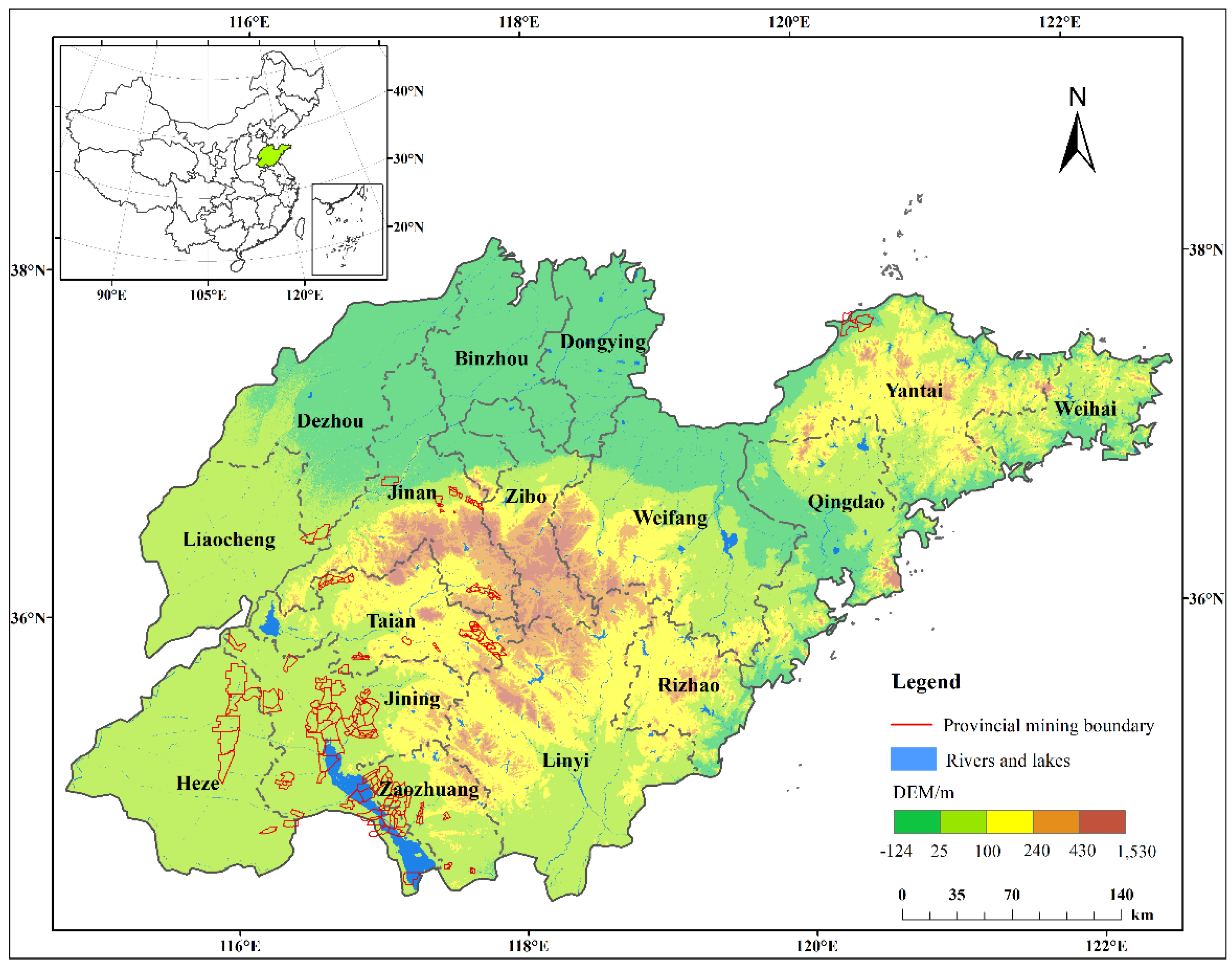
2.1. Overview of the Study Area

2.1.1. Natural Condition

Shandong Province is located on the east coast of China and in the lower reaches of the Yellow River. It borders Hebei, Henan, Anhui, and Jiangsu from north to south (Figure 1). The mountains in the center of Shandong Province are projecting, those in the southwest and northwest are low-lying and flat, and the east has gentle hills and undulations. The territory has a high phreatic level, abundant water sources, concentrated precipitation, fertile soil, and China’s highest arable land rate. It is an important agricultural area for grain, cotton, and oil products. The province’s land area is 15.80 × 10⁴ km2, accounting for 1.64% of the country’s total area, and the cultivated land area is 7.52 × 10⁴ km2, accounting for 6.17% of the country’s total cropland area. The agricultural conditions in the territory are excellent, and crops are grown in both summer and autumn. Wheat, corn, and sweet potatoes are the three major local food crops.
In addition, Shandong Province has rich mineral reserves, including 15 pillar minerals that the national economy depends on for development. It is one of China’s 14 large-scale coal production bases, the Luxi coal base. Its coal-bearing area is about 1.65 × 10⁴ km2, accounting for 10.45% of the province’s total land area. By the end of 2020, the province had 102 production mines and 3 mines under construction, mainly scattered around Jining, Tai’an, Zaozhuang, Jinan, Heze, Yantai, and Dezhou City (Figure 1). Shandong province is one of the earliest provinces in China to discover, exploit, and utilize coal resources. Due to long-term mining, many subsidence areas have been formed on the ground. In particular, Shandong Province is a high-water-level area. Large-scale coal mining has resulted in severe land damage, and the situation of cultivated land protection is even more serious.

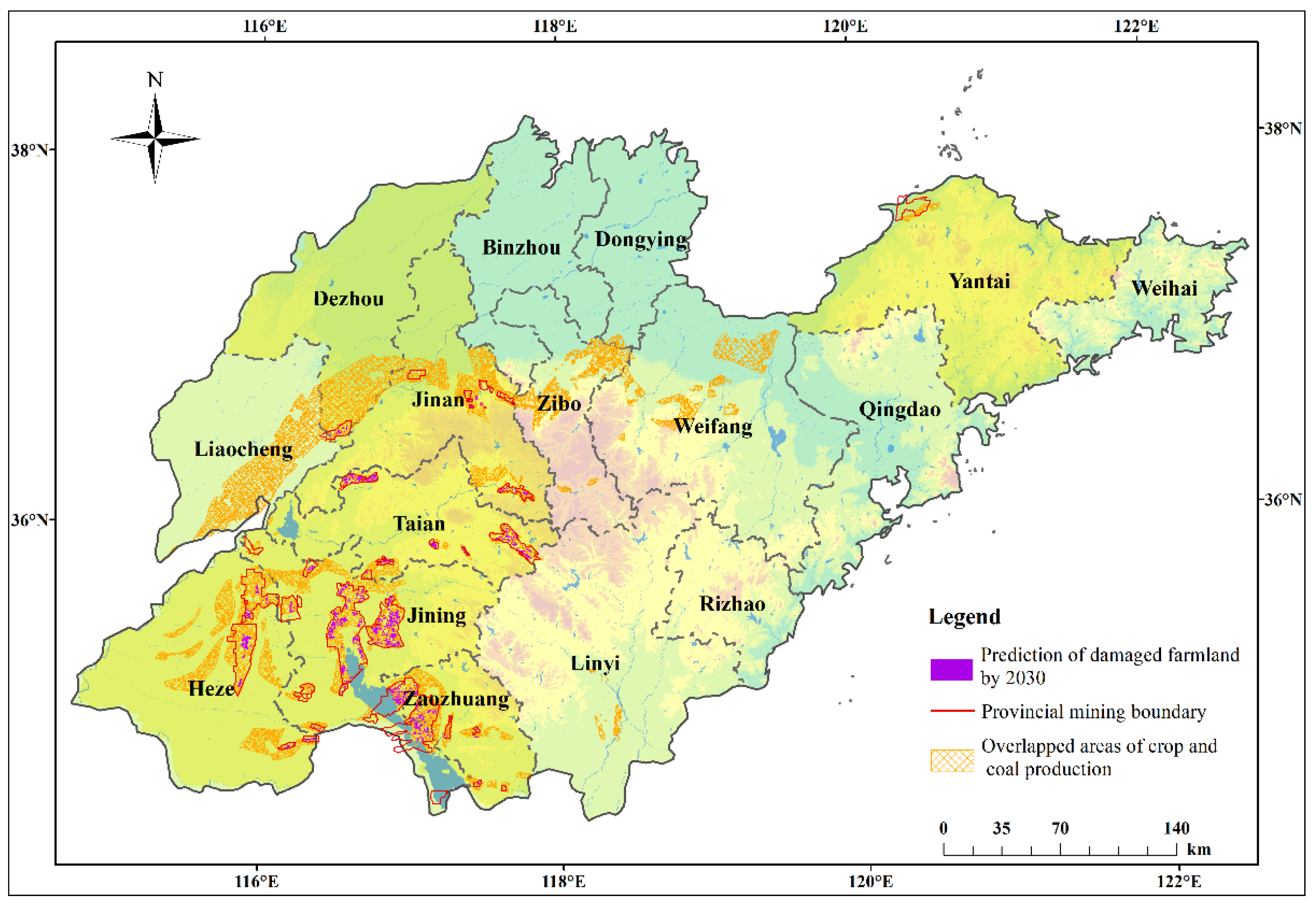
2.1.2. Distribution Characteristics of Coal–Crop Overlapped Areas

Using ArcGIS spatial analysis to superimpose the distribution map of coal resources and cropland resources, it was found that the overlapped areas of crop and coal production in Shandong Province are mainly around Heze City, Zaozhuang City, Jining City, Tai’an City, Liaocheng City, Dezhou City, Jinan City, Zibo City, Weifang City, and the northern part of Yantai City (Figure 2). The overlapped areas cover an area of 101.66 × 10⁴ ha, which account for 6.44%, 13.53%, and 64.61% of the province’s total land area, total cropland area, and coal-bearing area, respectively. The land use type in coal-bearing areas within Shandong Province was dominated by cultivated land. The established mining area in the province was 23.61 × 10⁴ ha, accounting for 23.22% of its area of overlapped crop and coal production.

2.2. Methods

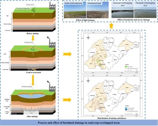
2.2.1. Current Situation of Damaged Farmland

Based on the subsidence area map provided by various mining areas in Shandong Province, this study developed a summary table for collecting various cities’ current coal mining subsidence areas. Simultaneously, the current state of cultivated land destruction was analyzed in detail based on the provincial government and several cities’ statistical planning data, in conjunction with several field studies and verifications.
The current area of coal mining subsidence, reduced-yield, and non-yield in the summary table, is provided by Shandong Provincial Energy Bureau, Natural Resources Bureau, and mining enterprises.

2.2.2. Mining Subsidence Prediction

The Mining Subsidence Prediction System (MSPS) can automatically calculate rock formations and surface deformation caused by coal mining based on mining conditions, prediction functions, and parameters. The mathematical models used by the software include the probability integral method, mountainous surface movement prediction model, and steep prediction model for coal seam mining. Among them, the probability integral method is commonly used for predicting mining subsidence in coal mining areas and is suitable for coal seams with an inclination angle of less than 45° [42]. The coal seams in all mining areas in Shandong Province are all near-level coal seams, thus conforming to the scope of application of the probability integral method. When all the coal seams in the mining area are fully mined, the amount of subsidence at any point A (x, y) on the surface is W A [43]. The calculation formula is shown in Equation (1).
W A = P f ( x ,   y ) d P = P W 0 r 2 e π ( x c ) 2 ( y t ) 2 r 2   d P ,
where W 0 represents the maximum sink value, and it satisfies the following Equation (2); r represents the main influence radius, and variable r satisfies the following Equation (3).
W 0 = m q cos α ,
where m denotes the mining thickness of the coal seam; q refers to the subsidence coefficient; α is the coal seam inclination.
r = H / tan β ,
where H stands for the elevation difference between the point A (x, y) to be calculated on the ground and the micro-element point (c, t) on the coal seam; tan β represents the main influence angle tangent; P refers to the mining area.
Consequently, this study collected each mining area’s overall development plan, geological report, annual mining plans, and mining engineering plan. It used MSPS software to simulate and predict the land subsidence affected by coal mining in each city in 2025 and 2030 based on the mining plan and mineral resource planning of each mine. The damage degree was further separated according to the groundwater level of each mine, the subsidence water accumulation, and the influence of subsidence on vegetation (Table 1). If there is no water accumulation on the surface, it is light damage; if there is seasonal water accumulation on the ground, it is minor damage; if there is perennial water accumulation, it is severe damage.

2.2.3. Damaged Farmland Forecast

Using the spatial analysis function of ArcGIS, the predicted coal mining subsidence data, water accumulation data, and coal–grain composite area were superimposed, and the composite factor was extracted to calculate the damaged cropland area by coal mining.

2.2.4. Construction of a Model for Farmland Yield Caused Coal Mining Subsidence

Severe subsidence caused by coal mining leads to cropland failure, while moderate and minor subsidence causes varying degrees of reduction in crop production. Moderate subsidence caused a decrease in grain production between 20% and 40%, whereas minor subsidence caused a decrease in grain production between 10% and 20% [44]. Therefore, combined with the study of cultivated land destruction in the coal–grain composite areas in eastern China [30], the reduction in cultivated land corresponding to severe, moderate, and minor subsidence was 100%, 30%, and 15%, respectively. Based on the above analysis, we constructed an estimation model (Equation (4)) to approximate the impact of cultivated land damage on grain output within in study area:
Q   =   E   ×   ( S 1 P 1   +   S 2 P 2   +   S 3 P 3 ) ,
where Q represents the quantity of grain reduction caused by subsidence in cropland; E represents the average grain yield (valued to 6329 kg/ha); S1, S2, and S3 represent the area of minor, moderate, and severe cropland damage, respectively; P1, P2, and P3 represent the proportion of grain reduction in minor, moderate, and severe subsided in the cropland, respectively.

3. Results

Based on the survey data analysis of farmland damage status and the prediction of mining subsidence according to the two stages of 2025 and 2030, the evolution law of farmland damage in composite areas of Shandong Province was intuitively reflected. Then, the grain reduction and other adverse effects were analyzed to support future cropland protection and subsidence land management planning.

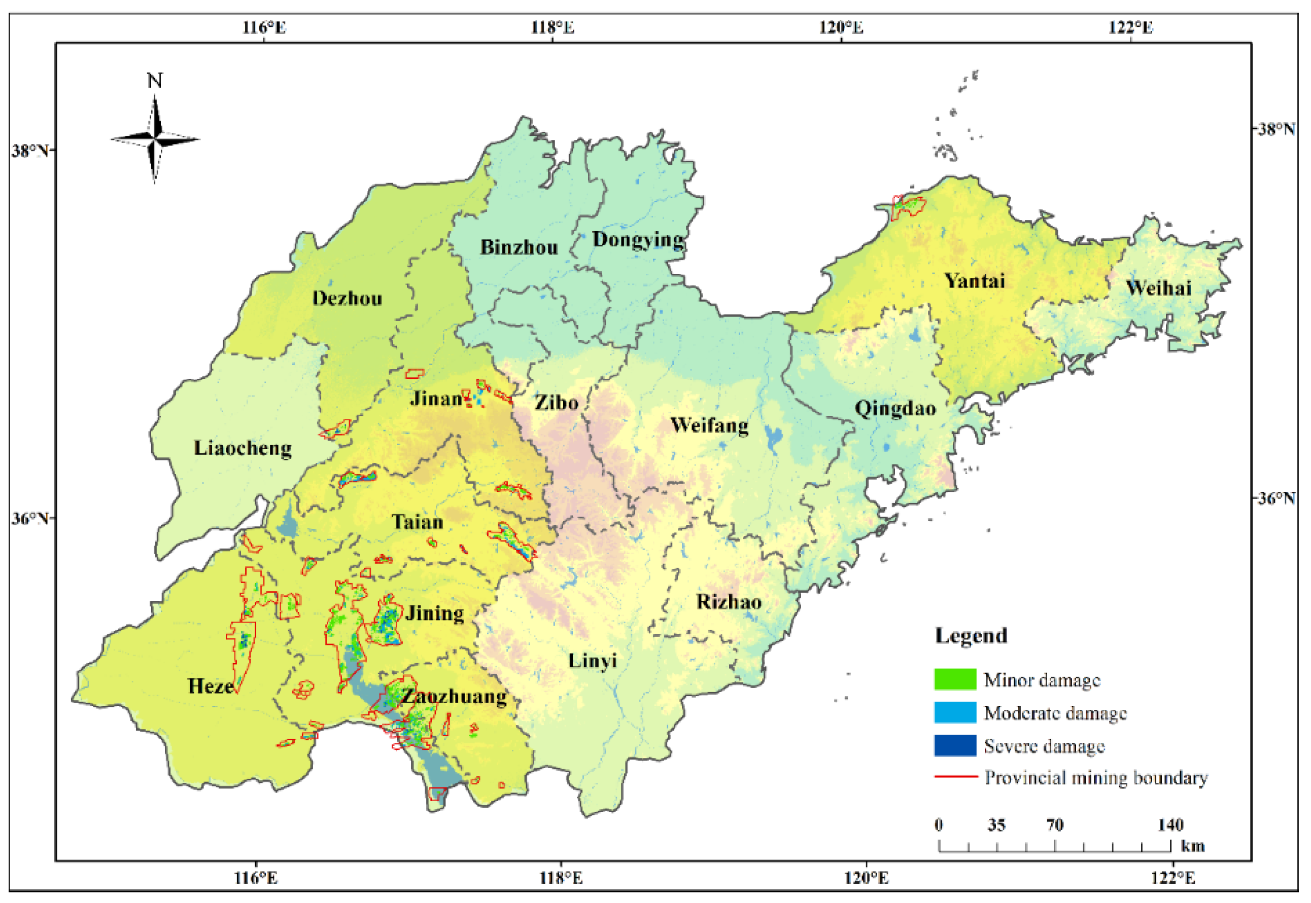
3.1. Current Distribution of Damaged Farmland

As revealed by survey statistics, as of the end of 2021, the land subsidence area affected by underground coal mining in Shandong Province had reached 8.26 × 10⁴ ha. Regarding land subsidence (Figure 3), cropland damage is distributed in Jining City, Tai’an City, Zaozhuang City, Jinan City, Heze City, Yantai City, and Dezhou City. Among them, Jinan City and Tai’an City have the most extensive damage range, and about 70% of the damaged farmland in Shandong Province focuses on these two cities.
As shown in Table 2, the damaged area of cultivated land in overlapped areas was as high as 6.40 × 10⁴ ha, including 5.00 × 10⁴ ha of reduced-yield farmland and 1.40 × 10⁴ ha of non-productive farmland. Within the entire province’s territory, disaster-affected cultivated land and non-yield farmland in Jining City are the largest, which are 2.90 × 10⁴ ha and 0.84 × 10⁴ ha, respectively. The damaged area accounts for 45.37% of the province’s total area of damaged farmland. It is followed by the damaged cultivated land area of 1.53 × 10⁴ ha in Tai’an City, accounting for 23.91% of the total area of damaged farmland in the province. The reduced and no-production farmland areas are 1.36 × 10⁴ ha and 0.17 × 10⁴ ha, respectively. The whole damaged area of Zaozhuang is 0.61 × 10⁴ ha, of which the reduced production area is 0.46 × 10⁴ ha, and the extinct production area is 0.15 × 10⁴ ha. The whole broken area in Jinan City is 0.65 × 10⁴ ha. Although it is not much different from the damaged area in Zaozhuang City, its reduced production area of 0.64 × 10⁴ ha is much larger than that in Zaozhuang City. Heze City and Yantai City are slightly damaged, with the damaged area accounting for 6.12% and 3.96% of the total damaged area. However, the cropland damaged area, reduced-productive area, and non-productive area in Heze City are higher than those in Yantai City. These areas are 0.25 × 10⁴ ha, 0.20 × 10⁴ ha, and 0.05 × 10⁴ ha in Yantai City. The area of cultivated land destruction in Dezhou City is the smallest, at 0.06 × 10⁴ ha. Still, the non-productive farmland area in the city is as high as 0.04 × 10⁴ ha, accounting for 64.96% of the total damaged farmland area in the city.

3.2. Spatiotemporal Distribution of Coal Mining Subsidence Prediction

According to the mining plans of various mines in Shandong Province, MSPS is used to predict the impact of coal mining subsidence in 2025 and 2030 (Figure 4 and Figure 5). It can be seen that from 2025 to 2030, the subsidence area caused by coal mining will gradually expand. Among them, the minor damage range gradually decreases, while the moderate and severe damage range continues to expand.
As shown in Table 3, the damage to the land by coal mining subsidence gradually increases. By 2025, it is estimated that the subsidence area of the study area will reach 10.27 × 10⁴ ha, accounting for 0.65% of the province’s total land area. Among them, the severe damage area is 0.82 × 10⁴ ha, accounting for 0.82% of the total cropland damaged area. By 2030, the subsidence area of the district will reach 12.26 × 10⁴ ha, accounting for 0.78% of the total land area. As seen in Table 3, the severe damage area is 1.37 × 10⁴ ha, accounting for 11.18% of the total cropland-damaged area. It follows that from 2021 to 2030, the subsidence area caused by coal mining will gradually expand. The proportion of minor damage area to total damaged area decreased, while the moderate and severe damage area increased.

3.3. Spatiotemporal Distribution of Farmland Damage Prediction

The subsidence prediction results and subsidence classification data in 2025 and 2030 were superimposed over the coal–grain composite area to obtain the data on cultivated land affected by coal mining, as shown in Figure 6 and Figure 7 and Table 4. It can be concluded that, from 2025 to 2030, the total damaged cropland area shows an increasing trend, and the damaged area of each damage degree is also expanding. By 2025, the damaged cropland area will reach 6.97 × 10⁴ ha, of which the severely damaged area will be 1.63 × 10⁴ ha, accounting for 23.44% of the total damaged cropland area. By 2030, the damaged cropland area will reach 7.52 × 10⁴ ha, of which the severely damaged area will be 1.89 × 10⁴ ha, accounting for 25.12% of the total damaged cropland area. The results indicate that by 2030, about 7.39% of the cultivated land in Shandong Province will be damaged due to coal mining, and the damage will become more serious. Furthermore, about 1.86% of the arable land will be submerged in water, forming perennial stagnant water areas that are unable to produce food.
There are also differences in the spatial distribution of cropland damage in different periods (Table 5 and Table 6). Except for Jinan City, which stopped coal mining in 2021, other cities will continue to expand coal mining from 2021 until at least 2030. Before 2025, the damaged farmland area in Jining City was the largest, with an area of 3.17 × 10⁴ ha. It is followed by Tai’an City, with an area of 1.51 × 10⁴ ha, and the smallest is Dezhou City, which has an area of 0.08 × 10⁴ ha. During 2025–2030, the damaged farmland area in Jining City is expected to increase the most, followed by Heze City, with Yantai City increasing the least. Compared with the period from 2021 to 2025, except for Jining City, Heze City, and Dezhou City, the area of each damage degree has changed significantly, and other cities have not changed much.

3.4. Impact and Assessment of Farmland Damage

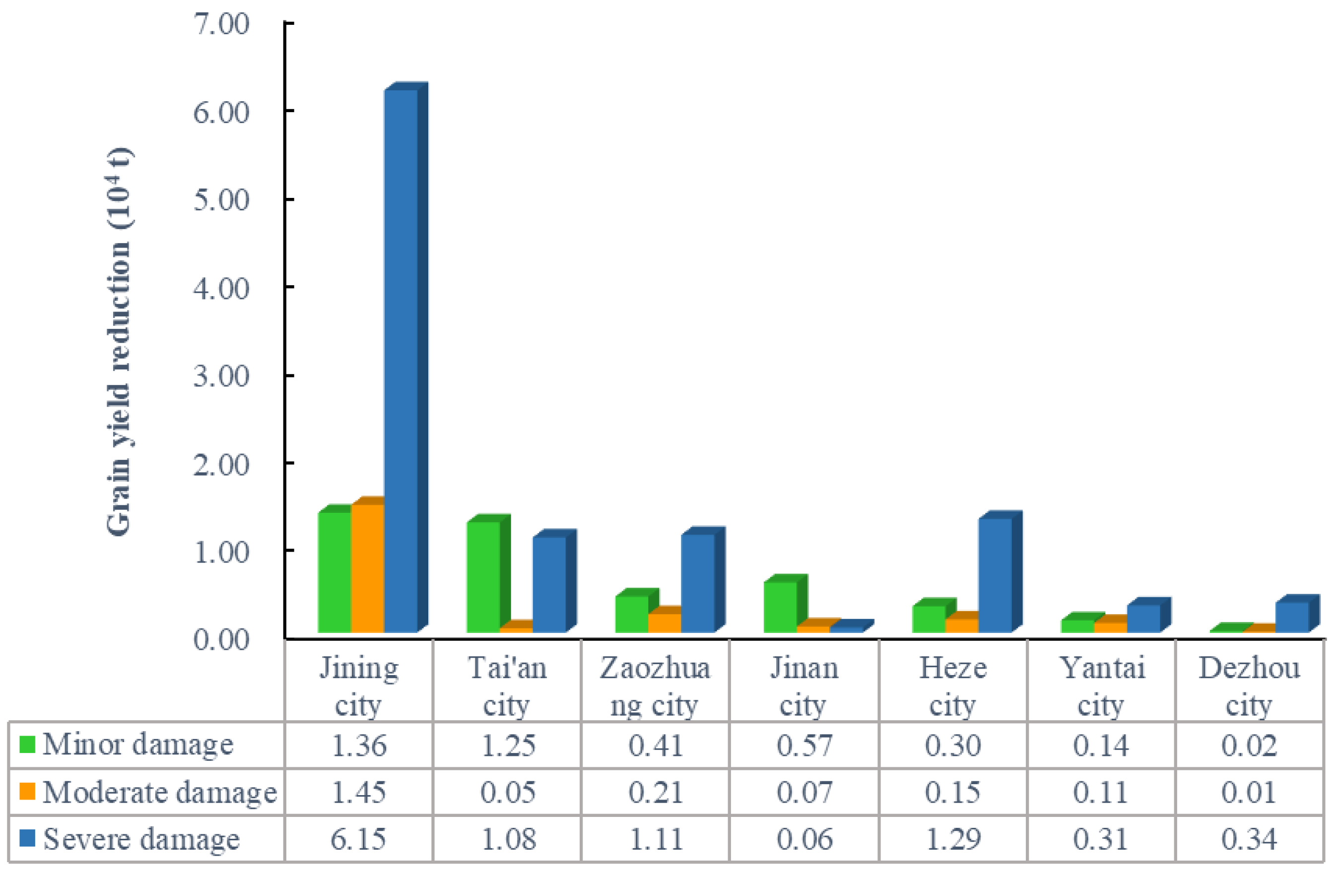
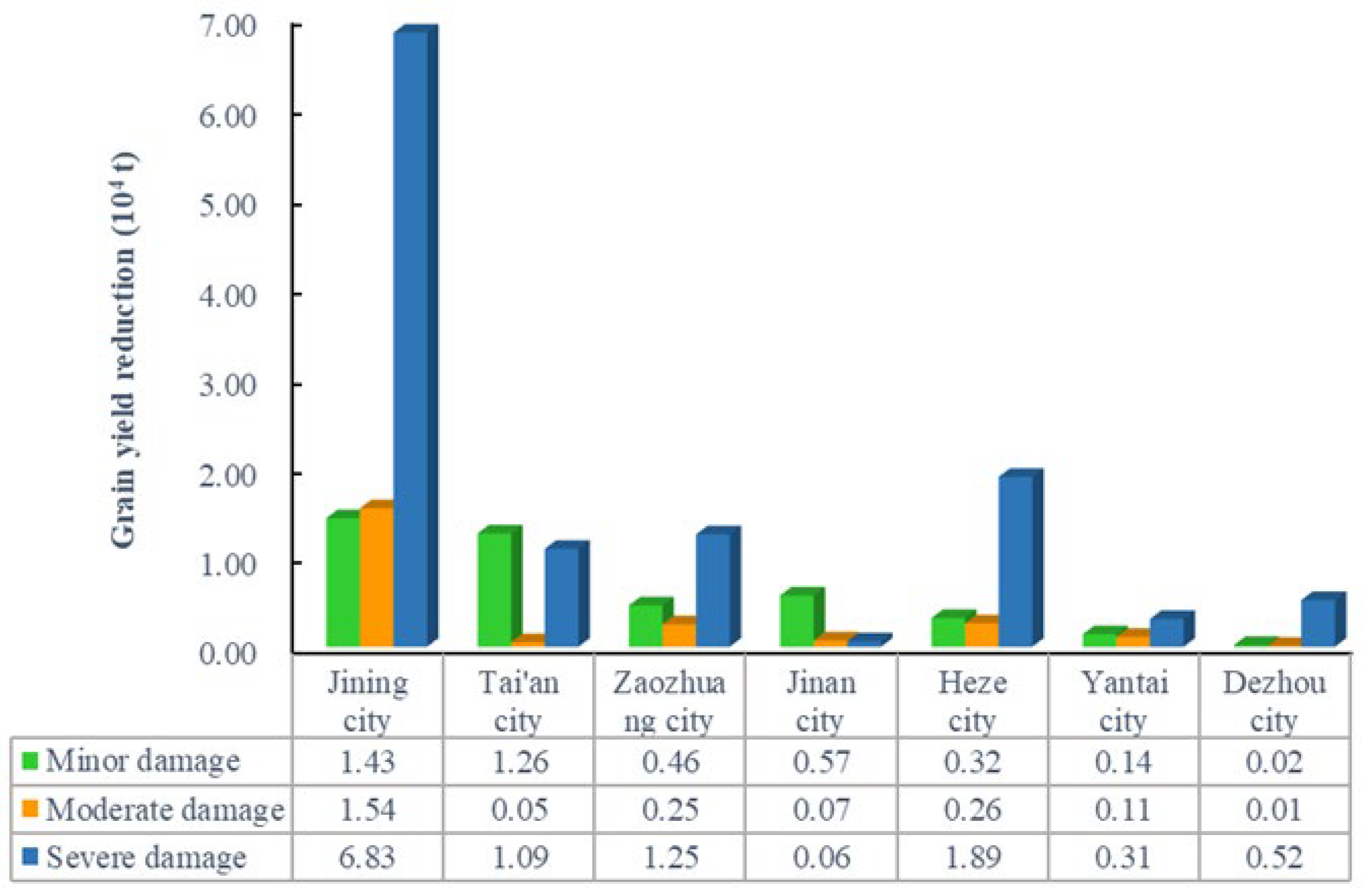
3.4.1. Reduced Grain Production

Land subsidence has highly adverse effects on agricultural production. Coal mining destroys the surrounding soil layers, changes the infiltration conditions and evaporation paths of cultivated land, and seriously affects the water environment and nutrient environment of the cultivated soil, resulting in the decline of soil productivity and the failure of crops to grow normally. In areas with high groundwater levels, subsidence caused serious water accumulation in cultivated land and damaged agricultural supporting facilities. These disruptions severely affected food production and cash crop planting, leading to reduced agricultural output or, in some cases, total crop failure. Apart from some farmers being forced to adjust from their previous planting industry to aquaculture, many farmers have no growing land, and agricultural economic losses are profound.
According to the analysis of the forecast results and the estimation of the grain production reduction model (Equation (4)), by 2025 and 2030, grain production will be reduced by 16.44 × 10⁴ t and 18.45 × 10⁴ t, respectively. Figure 8 and Figure 9 show that from 2025 to 2030, the grain yield reduction in Jining City will change the most. Except for Jinan City, which will see no change in grain production due to no longer mining after 2021, there will be no change in grain yield reduction in Yantai City and the extent of partial damage in other cities, mainly because the damaged area will change little. It is estimated that by 2030, minor, moderate, and severe damage will cause a reduction in grain output of 4.19 × 10⁴ t, 2.30 × 10⁴ t, and 11.95 × 10⁴ t, accounting for 22.73%, 12.47%, and 64.80% of the total decline in output, respectively. In summary, local grain production will be greatly reduced due to continuous mining, which will significantly hinder the development of agricultural production.

3.4.2. Change of Farmland Landscape Pattern

With the disturbance of coal mining, the surface collapsed on a large scale (Figure 10). Contiguous deep subsidence basins were formed in some areas such as Jining City, Zaozhuang City, and Heze City, resulting in the gradual evolution of flat farmland into sloping fields, perennial waterlogging areas, seasonal waterlogging areas, etc. Continuous coal production will inevitably lead to larger-scale surface subsidence, and the farmland landscape will change accordingly. By the end of 2025, the accumulated water area of cultivated land in the coal–grain compound zone in Shandong Province will be 2.71 × 10⁴ ha, and by the end of 2030, the accumulated water area will increase to 3.10 × 10⁴ ha. Most of the increased water is coming from cropland. Cropland has lost its landscape advantages, and water landscape advantages have risen significantly. Currently, Shandong Province is optimizing and adjusting the layout of coal resource development in the province and reducing the existing production capacity. In the future, surface subsidence will slowly increase, and the extent of cultivated land evolving into stagnant water and converging with sloping cropland will also increase.

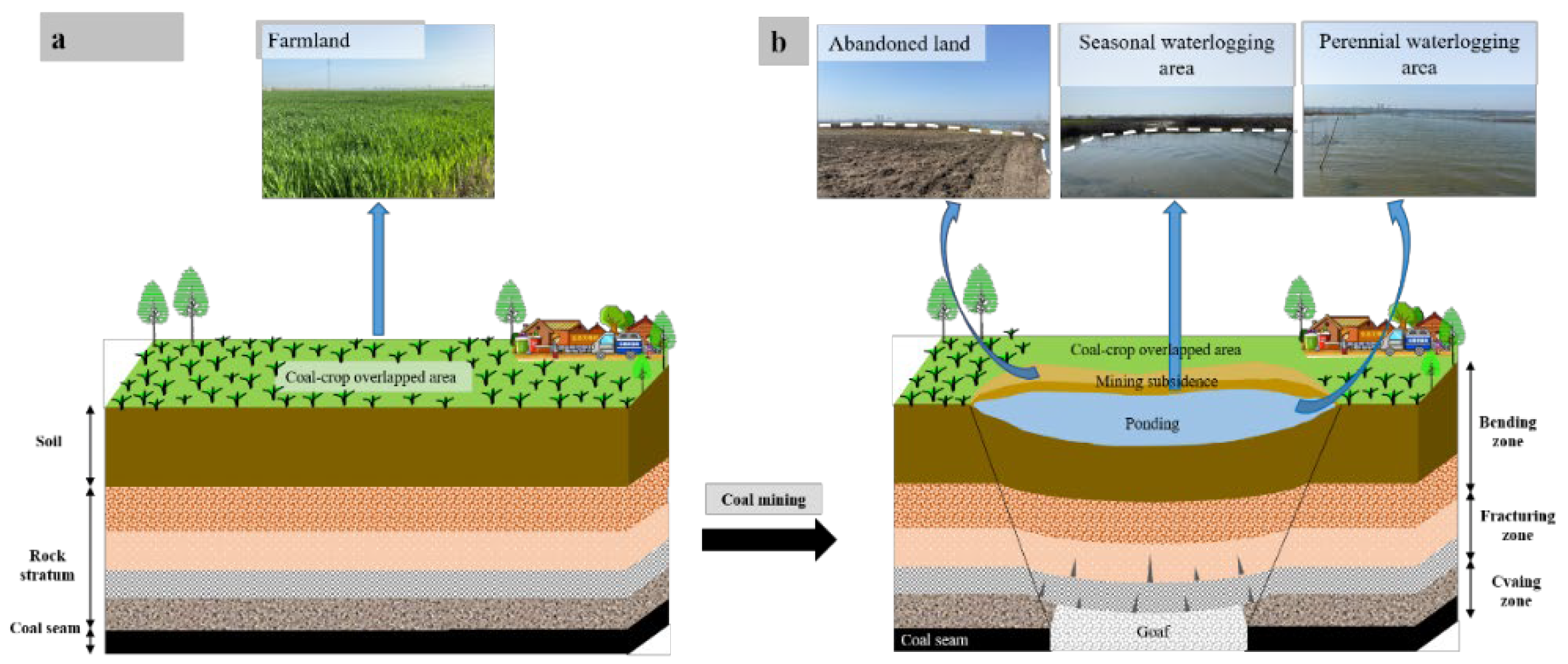
3.4.3. Damage to Ecological Environment

As shown in Figure 11, during the coal mining process, it is easy to destroy the land structure of the mining area and its surrounding areas. The collapse of coal mining causes slopes in formerly flat farmland, disturbing the originally relatively stable soil structure and geological environment [45,46,47,48]. Slight neglect of coal mining may adversely affect the groundwater system and destroy the balance of the groundwater system, resulting in surface water leakage in mining areas and causing extensive water accumulation in damaged cropland [49]. In addition to the combined effects of topography and climate, the vegetation in the goaf will also be severely damaged. The vegetation in the subsidence areas will take a long time to recover [50], causing the ecological environment to be forced into a vicious circle, bringing severe hidden dangers to mining area development.
This study predicts that by 2025, an area of 2.71 × 10⁴ ha of cropland ecosystem will be transformed into a wetland ecosystem in Shandong province due to coal mining if no relevant control measures are taken. By 2030, the study area will have an area of about 3.10 × 10⁴ ha of cropland ecosystems transformed. The balance of the original cropland ecosystem will be disrupted, and the system energy flow and logistics will be blocked by the external circulation, resulting in a drastic reverse change in the cropland ecological environment. Living organisms will lose their habitat and niches, crops will not grow normally, and cropland ecological safety will decline.

4. Discussion

4.1. Impact of Farmland Damage on Social Stability

Shandong Province, as a typical coal–grain complex area where farmers’ income, agricultural product supply, mine output, and miner safety are the most important areas of the ‘three rural’ and ‘four mines’ issues. After coal mining, large cultivated land areas lie under accumulated water, topsoil resources are eroded, and soil organic matter is lost [51,52,53]. It is estimated that the soil loss will increase by about 20% for every 1° increase in the original grainland slope. At the same time, the tillage layer becomes shallow, generally from 25 cm to 15 cm. Compared with the normal cultivated land, the organic matter content of the subsidence-affected cultivated land decreases by about 30% [31]. Farmland damage, area reduction, and productivity decline lead to many farmers’ income reduction and employment pressure increase. Surface subsidence and surface cracks caused by mining destroy buildings, traffic roads, and communication lines and greatly inconvenience farmers’ production and life [54,55]. On issues such as compensation for land damage, land acquisition, land reclamation, village demolition, and personnel resettlement, local governments, mining enterprises, and farmers continue to have disputes and prominent disagreements, which can seriously affect the harmony and stability of local communities.
Because Shandong Province is also a high groundwater level area, damaged farmland will appear to be waterlogging and even become a perennial waterlogging area. As a result, the reclamation cost increases, and the reclamation rate decreases, which brings many inconveniences to the reclamation work.
In conclusion, considering the current scale of coal mining, the subsidence area will be further increased in the future. The damage of subsidence to land resources, the negative impact on agriculture, ecology, and society, and the negative impact on the production, living, and living of residents in the subsidence area will be further increased. Mining areas should combine with the actual local situation and implement green mining technology to reduce these negative impacts caused by surface subsidence from the source [56,57]. According to the predicted damage to cropland, the mining areas can choose appropriate reclamation time, elevation, and layout to simulate the reclamation scenario while mining and change the traditional land reclamation method [58]. With the goal of restoring grainland, increasing reclamation rate, and reducing reclamation cost, the main measures for cultivated land protection and reclamation are proposed by combining natural restoration and engineering measures. Facing other problems such as water accumulation and facilities destruction in subsidence areas, the government and mining area should reasonably plan and design an ecological reconstruction scheme from the aspects of water accumulation degree, waste utilization, and farmers’ demand to create an efficient ecological agriculture landscape [59].

4.2. Limitations and Outlooks

There is an interaction effect between coal mining and grain production in COA. The time continuity, spatial scalability, and substantial interference of coal mining have seriously threatened the high-quality cultivated land. What makes it worse is that such a threat will be intensified in time and space dimensions, thus threatening the sustainable development of the mining area. Therefore, it is key to coordinate coal mining and farmland protection to study cropland damage and its impact on the overlapped areas. In the past, the prediction of cropland destruction was mostly based on empirical models [20,31], or the probability integral method was used to predict cropland damage on a small scale [35]. Therefore, in this paper, the provincial scale is selected to predict the change of cropland destruction with the coal mining development in overlapped areas. The analysis of the current situation and future trend of cropland damage indicates that damage caused by long-term, large-scale, and high-intensity coal mining continues to increase, and the damage degree continues to change. This result is consistent with the characteristics of cropland damage caused by coal mining in the region [60]. In addition, previous studies revealed the impact of cropland damage using quantitative or qualitative analysis methods from the soil, vegetation, agriculture, ecological environment, and other aspects [61,62,63,64]. These provide the foundation for this study to analyze the impact of coal mining on cultivated land in Shandong Province. Through calculation, investigation, and literature analysis, it was found that the ever-changing scope of grainland damage will cause changes in the soil quality, landscape pattern, and ecological environment quality in the region and bring many social problems.
However, due to the complexity of the evolution process of cropland damage, certain errors will occur when predicting its evolution law. In addition, the change of cropland landscape patterns and ecological environment is a relatively complex process, which is affected not only by coal mining but also by geological conditions, climate, human activities, and other factors in the coal mining area. The factors of cultivated land destruction also involve many aspects. Therefore, it is worthy of further study to fully consider the influencing factors of cropland damage in the coal–grain composite areas and reduce the error between the predicted area and the actual damage. Meanwhile, it is necessary to analyze further the impact of cultivated land destruction on mining areas and its impact mechanism.

5. Conclusions

Coal and cropland resources in COA have a large overlapped area and a wide distribution range. Coal mining will inevitably cause a large amount of farmland damage. Based on the provincial scale, taking Shandong Province as an example, this paper analyzed the spatiotemporal impact of coal mining on cropland in coal–cropland overlapping areas. The research results suggest that the cropland area in overlapped regions will continue to decrease with the continuous exploitation of coal resources. The damage degree will continue to increase, seriously affecting local agriculture, the environment, and social stability. The research results lay a foundation for other coal–grain complex areas to clarify the current situation, trend, and mechanism of cropland damage. At the same time, grasping the temporal and spatial impact of mining on cropland in overlapped areas is also the premise and basis for formulating coordinated countermeasures for mining and cropland protection.
Therefore, it is recommended that relevant departments consider the following points when formulating grainland protection plans: (1) overlapping characteristics and evolution trends of damaged cropland should be fully considered. (2) Appropriate reclamation methods should be selected. Concurrent mining and reclamation technology can be promoted for areas with high groundwater levels to save more topsoil resources in advance. (3) It is necessary to rebuild the ecological environment according to local conditions. In addition, we should vigorously promote the green mining technology of coal mines to reduce the impact of coal mining subsidence from the source.
Given the limitations of this study, future research needs to pay more attention to how to reduce the error between the predicted damage and the actual damage and explore the impact mechanism of farmland damage on the mining area development to realize the sustainable development of coal mining and farmland protection.

Author Contributions

Conceptualization, Z.H.; methodology, Y.C.; validation, J.G.; formal analysis, Y.C.; investigation, P.L.; resources, Z.H.; data curation, D.Y.; writing—original draft preparation, Y.C.; writing—review and editing, G.L.; visualization, Y.C.; supervision, J.G.; project administration, D.Y.; funding acquisition, Z.H. All authors have read and agreed to the published version of the manuscript.

Funding

This work was financially supported by the National Natural Science Foundation of China (No. 41771542).

Institutional Review Board Statement

Not applicable.

Informed Consent Statement

Not applicable.

Data Availability Statement

The data presented in this study are available on request from the corresponding author.

Acknowledgments

The authors would like to express appreciation to the Shandong Provincial Department of Natural Resources and coal mines for their great help, and we also thank the National Natural Science Foundation of China for its support of this study. We are grateful to the academic editors and anonymous reviewers for their valuable opinions and comments.

Conflicts of Interest

The authors declare no conflict of interest.

References

  1. Xu, J.; Ma, N.; Xie, H. Ecological Coal Mining Based Dynamic Equilibrium Strategy to Reduce Pollution Emissions and Energy Consumption. J. Clean. Prod. 2017, 167, 514–529. [Google Scholar] [CrossRef]
  2. Dai, S.; Ren, D.; Chou, C.L.; Finkelman, R.B.; Seredin, V.V.; Zhou, Y. Geochemistry of Trace Elements in Chinese Coals: A Review of Abundances, Genetic Types, Impacts on Human Health, and Industrial Utilization. Int. J. Coal Geol. 2012, 94, 3–21. [Google Scholar] [CrossRef]
  3. Li, Y.; Chiu, Y.H.; Lin, T.Y. Coal Production Efficiency and Land Destruction in China’s Coal Mining Industry. Resour. Policy 2019, 63, 101449. [Google Scholar] [CrossRef]
  4. Bian, Z.; Lei, S.; Jin, D.; Wang, L. Several Basic Scientific Issues Related to Mined Land Remediation. Meitan Xuebao J. China Coal Soc. 2018, 43, 190–197. [Google Scholar]
  5. Hu, Z.; Fu, Y.; Xiao, W.; Zhao, Y.; Wei, T. Ecological Restoration Plan for Abandoned Underground Coal Mine Site in Eastern China. Int. J. Min. Reclam. Environ. 2015, 29, 316–330. [Google Scholar] [CrossRef]
  6. He, T.; Xiao, W.; Zhao, Y.L.; Deng, X.; Hu, Z. Identification of Waterlogging in Eastern China Induced by Mining Subsidence: A Case Study of Google Earth Engine Time-Series Analysis Applied to the Huainan Coal Field. Remote Sens. Environ. 2020, 242, 111742. [Google Scholar] [CrossRef]
  7. Liu, S.; Li, W.; Qiao, W.; Wang, Q.; Hu, Y.; Wang, Z. Effect of Natural Conditions and Mining Activities on Vegetation Variations in Arid and Semiarid Mining Regions. Ecol. Indic. 2019, 103, 331–345. [Google Scholar] [CrossRef]
  8. Hu, Z.; Liu, S.; Gong, Y. Evaluation of Soil Quality and Maize Growth in Different Profiles of Reclaimed Land with Coal Gangue Filling. Land 2021, 10, 1307. [Google Scholar] [CrossRef]
  9. Xiao, W.; Hu, Z.; Fu, Y. Zoning of Land Reclamation in Coal Mining Area and New Progresses for the Past 10 Years. Int. J. Coal Sci. Technol. 2014, 1, 177–183. [Google Scholar] [CrossRef]
  10. Ren, H.; Zhao, Y.; Xiao, W.; Hu, Z. A Review of UAV Monitoring in Mining Areas: Current Status and Future Perspectives. Int. J. Coal Sci. Technol. 2019, 6, 320–333. [Google Scholar] [CrossRef]
  11. Xu, J.; Li, G.; Chen, G.; Zhao, H. Dynamic Changes and Evaluation of Land Ecological Quality in Coal Mining Area. J. China Coal Soc. 2013, 38, 180–185. [Google Scholar]
  12. He, X.; Song, L. Status and Future Tasks of Coal Mining Safety in China. Saf. Sci. 2012, 50, 894–898. [Google Scholar] [CrossRef]
  13. Feng, Y.; Wang, J.; Bai, Z.; Reading, L. Effects of Surface Coal Mining and Land Reclamation on Soil Properties: A Review. Earth Sci. Rev. 2019, 191, 12–25. [Google Scholar] [CrossRef]
  14. Bian, Z.; Miao, X.; Lei, S.; Chen, S.E.; Wang, W.; Struthers, S. The Challenges of Reusing Mining and Mineral-Processing Wastes. Science 2012, 337, 702–703. [Google Scholar] [CrossRef]
  15. Hu, Z.; Duo, L.; Wang, X. Principle and Method of Reclaiming Subsidence Land with Inter-Layers of Filling Materals. Meitan Xuebao/J. China Coal Soc. 2018, 43, 198–206. [Google Scholar]
  16. Lu, C.; Lu, C.; Li, H.; Liu, B.; Sun, Q.; Li, C. Groundwater Influencing Mechanism in Water-Ponding Process of Huainan Coal Mining Subsidence Area. Trans. Chin. Soc. Agric. Eng. 2015, 10, 122–131. [Google Scholar]
  17. He, T.; Xiao, W.; Zhao, Y.; Chen, W.; Deng, X.; Zhang, J. Continues Monitoring of Subsidence Water in Mining Area from the Eastern Plain in China from 1986 to 2018 Using Landsat Imagery and Google Earth Engine. J. Clean. Prod. 2021, 279, 123610. [Google Scholar] [CrossRef]
  18. Hu, Z.; Shao, F.; McSweeney, K. Reclaiming Subsided Land with Yellow River Sediments: Evaluation of Soil-Sediment Columns. Geoderma 2017, 307, 210–219. [Google Scholar] [CrossRef]
  19. Xiao, W.; Fu, Y.; Wang, T.; Lv, X. Effects of Land Use Transitions Due to Underground Coal Mining on Ecosystem Services in High Groundwater Table Areas: A Case Study in the Yanzhou Coalfield. Land Use Policy 2018, 71, 213–221. [Google Scholar] [CrossRef]
  20. Hu, Z.; Li, J.; Zhao, Y. Problems, Reasons and Countermeasures for Environmental Quality and Food Safety in the Overlapped Areas of Crop and Mineral Production. Sci. Technol. Rev. 2006, 3, 21–24. [Google Scholar]
  21. Hu, Z.; Luo, Y. Suggestion on Environmental Quality and Food Safety in Overlapped Areas of Crop and Mineral Production. Sci. Technol. Rev. 2006, 3, 93–94. [Google Scholar]
  22. Chugh, Y.P. Concurrent Mining and Reclamation for Underground Coal Mining Subsidence Impacts in China. Int. J. Coal Sci. Technol. 2018, 5, 18–35. [Google Scholar] [CrossRef]
  23. Yang, G.; Yang, Y.; Gao, Y.; Yu, Y.; Lin, S.; Li, Y. Farmland Damage and Treatment Status in Coal Mining Subsidence Area with High Phreatic Water Level. Adv. Mater. Res. 2014, 838–841, 2190–2194. [Google Scholar] [CrossRef]
  24. Wang, J.; Chen, Y.; Shao, X.; Zhang, Y.; Cao, Y. Land-Use Changes and Policy Dimension Driving Forces in China: Present, Trend and Future. Land Use Policy 2012, 29, 737–749. [Google Scholar] [CrossRef]
  25. Deng, X.; Zeng, M.; Xu, D.; Wei, F. Household Health and Cropland Abandonment in Rural China: Theoretical Mechanism and Empirical Evidence. Int. J. Environ. Res. Public Health 2019, 16, 3588. [Google Scholar] [CrossRef]
  26. Asr, E.T.; Kakaie, R.; Ataei, M.; Tavakoli Mohammadi, M.R. A Review of Studies on Sustainable Development in Mining Life Cycle. J. Clean. Prod. 2019, 229, 213–231. [Google Scholar] [CrossRef]
  27. Li, Q.; Stoeckl, N.; King, D.; Gyuris, E. Exploring the Impacts of Coal Mining on Host Communities in Shanxi, China—Using Subjective Data. Resour. Policy 2017, 53, 125–134. [Google Scholar] [CrossRef]
  28. Li, L.; Lei, Y.; Wu, S.; He, C.; Yan, D. Study on the Coordinated Development of Economy, Environment and Resource in Coal-Based Areas in Shanxi Province in China: Based on the Multi-Objective Optimization Model. Resour. Policy 2018, 55, 80–86. [Google Scholar] [CrossRef]
  29. Zhang, M.; Wang, J.; Feng, Y. Temporal and Spatial Change of Land Use in a Large-Scale Opencast Coal Mine Area: A Complex Network Approach. Land Use Policy 2019, 86, 375–386. [Google Scholar] [CrossRef]
  30. Hu, Z.; Yang, G.; Xiao, W.; Li, J.; Yang, Y.; Yu, Y. Farmland Damage and Its Impact on the Overlapped Areas of Cropland and Coal Resources in the Eastern Plains of China. Resour. Conserv. Recycl. 2014, 86, 1–8. [Google Scholar] [CrossRef]
  31. Li, J.; Hu, Z.; Li, L. Farmland Damage and Its Impacts in Overlapped Areas of Cropland and Coal Resources in One Typical City of China. J. Liaoning Tech. Univ. 2008, 27, 148–151. [Google Scholar]
  32. Song, Y.; Hu, Z.; Chen, S.; Li, L. Plantation-Evolution Forecasting System in the Overlapping Area of Crop and Coal Production. Coal Eng. 2008, 02, 123–125. [Google Scholar]
  33. Zhao, X.; Li, J.; Liu, Z.; Li, W.; Zhang, P.; Zhou, S. Evaluation of Damaged Farmland Extent in Overlapped Areas of Farmland and Coal Resources with High Phreatic Water Level. Environ. Sci. Technol. 2014, 37, 177–181+192. [Google Scholar]
  34. Shi, X.; Hu, Z.; Hou, Z.; Li, Y. Plantation-Evolution Forecast of the Overlapped Area of Crop and Coal Production on a Small Scale. Met. Mine 2013, 42, 134–137. [Google Scholar]
  35. Chen, J.P.; Hu, Z.Q.; Yuan, D.Z.; Zhang, R.Y.; Xu, T. Prediction and Influence of Cultivated Land Evolution in the Overlapped Area of Crop and Coal Production in Fengtai County. J. Min. Sci. Technol. 2018, 3, 13–21. [Google Scholar]
  36. Yan, H.; Ding, Z.; Li, G. Conservation of Prime Farmland in Overlapped Areas of Cropland and Coal Resources. Hubei Agric. Sci. 2011, 50, 1984–1987. [Google Scholar]
  37. Gao, T.; Zhao, H. Contradiction between Coal Mining and Basic Farm Protection and Coordination. Sci. Technol. Manag. L. Resour. 2011, 2, 115–118. [Google Scholar]
  38. Yang, Z.; Hou, H.; Ding, Z.; Wang, H. Reclassification and Ecological Effect Analysis of Farmland Ecosystem in Overlapped Areas of Farmland and Coal Resources. Jiangsu Agric. Sci. 2018, 22, 280–286. [Google Scholar]
  39. Li, L.; Zhao, Y.; Yang, L. Study on Changes of Ecosystem Service Value of Overlapped Area of Coal and Crop—A Case Study of Zoucheng City. Resour. Dev. Mark. 2008, 3, 205–207. [Google Scholar]
  40. Wang, L.; Zhang, H.; Hu, W.; Yu, Z. Functional Evaluation of Land Use Based on Production-Living-Ecology View in Areas of Cropland and Coal Resources. Bull. Soil Water Conserv. 2018, 38, 301–306. [Google Scholar]
  41. Ma, S.; Xie, F.; Ding, C.; Zhang, H. Spatio-Temporal Change of Landscape Ecological Quality and Influencing Factors Based on Four-Quadrant Model in Overlapped Area of Cropland and Coal Production. Trans. Chin. Soc. Agric. Eng. 2020, 36, 259–268+323. [Google Scholar]
  42. Zhang, B.; Zhang, L.; Yang, H.; Zhang, Z.; Tao, J. Subsidence Prediction and Susceptibility Zonation for Collapse above Goaf with Thick Alluvial Cover: A Case Study of the Yongcheng Coalfield, Henan Province, China. Bull. Eng. Geol. Environ. 2016, 75, 1117–1132. [Google Scholar] [CrossRef]
  43. He, G. Mining Subsidence Science; China University of Mining and Technology Press: Beijing, China, 1991. [Google Scholar]
  44. Jiao, H. Research on the Development Model of Coal City in China; Peking University: Beijing, China, 1998. [Google Scholar]
  45. Zhao, Y.; Xu, X.; He, T.; Li, Y.; Hu, J. Changes of Land Use and Environment in Underground Coal Mining Area in China. Disaster Adv. 2013, 6, 125–131. [Google Scholar]
  46. Zhang, B.; Luo, H.; Lv, L.; Wang, J.; Zhang, B. Analysis of Ecological Environment Impact of Coal Exploitation and Utilization. IOP Conf. Ser. Earth Environ. Sci. 2018, 121, 032002. [Google Scholar] [CrossRef]
  47. Wu, X.; Pan, W. Investigation of Effect of Coal Resources Exploitation on Ecological Environment in China. China Sci. 2014, 9, 600–604. [Google Scholar]
  48. Antwi, E.K.; Krawczynski, R.; Wiegleb, G. Detecting the Effect of Disturbance on Habitat Diversity and Land Cover Change in a Post-Mining Area Using GIS. Landsc. Urban Plan. 2008, 87, 22–32. [Google Scholar] [CrossRef]
  49. Luan, J.; Zhang, Y.; Tian, J.; Meresa, H.; Liu, D. Coal Mining Impacts on Catchment Runoff. J. Hydrol. 2020, 589, 125101. [Google Scholar] [CrossRef]
  50. Yan, M.; Fan, L.; Wang, L. Restoration of Soil Carbon with Different Tree Species in a Post-Mining Land in Eastern Loess Plateau, China. Ecol. Eng. 2020, 158, 106025. [Google Scholar] [CrossRef]
  51. Ge, D.; Long, H.; Zhang, Y.; Li, M.; Li, T. Farmland Transition and Its Influences on Grain Production in China. Land Use Policy 2018, 70, 94–105. [Google Scholar] [CrossRef]
  52. Diao, X.; Wu, K.; Zhou, D.; Li, L. Integrating the Probability Integral Method for Subsidence Prediction and Differential Synthetic Aperture Radar Interferometry for Monitoring Mining Subsidence in Fengfeng, China. J. Appl. Remote Sens. 2016, 10, 016028. [Google Scholar] [CrossRef]
  53. Wang, J.; Wang, P.; Qin, Q.; Wang, H. The Effects of Land Subsidence and Rehabilitation on Soil Hydraulic Properties in a Mining Area in the Loess Plateau of China. Catena 2017, 159, 51–59. [Google Scholar] [CrossRef]
  54. Gao, C.; Xu, N.; Liu, G.; Tian, G. Effect of Roadway Layout in Protective Coal Pillar on Subsidence of Buildings Such as Villages. Coal Eng. 2019, 51, 116–120. [Google Scholar]
  55. Chen, J.; Hu, Z.; Yuan, D.; Zhao, H. Change of Farming Radius of Relocated Villages and Its Influence in Coal Mining Subsidence Areas. Trans. Chin. Soc. Agric. Eng. 2019, 35, 287–295. [Google Scholar]
  56. Qian, M.; Xu, J.; Miao, X. Green Technique in Coal Ming. J. China Univ. Min. Technol. 2003, 04, 5–10. [Google Scholar]
  57. Guo, W.; Zhao, G.; Bai, E.; Ma, C.; Nie, X.; Chen, J.; Zhang, H. Research Status and Prospect on Cultivated Land Damage at Surface Subsidence Basin Due to Longwall Mining in the Central Coal Grain Compound Area. J. China Coal Soc. 2022, 1–12. [Google Scholar] [CrossRef]
  58. Wu, X.; Zhenqi, H.; Riuya, Z.; Yanling, Z. A Simulation of Mining Subsidence and Its Impacts to Land in High Ground Water Area—An Integrated Approach Based on Subsidence Prediction and GIS. Disaster Adv. 2013, 6, 142–148. [Google Scholar]
  59. Fu, M.; Hu, Z.; Liu, S. Farmland Restoration and Pollution Prevention in the Overlapped Areas of Crop and Mineral Production. Met. Mine 2008, 9, 119–122. [Google Scholar]
  60. Wu, Q.; Pang, J.; Qi, S.; Li, Y.; Han, C.; Liu, T.; Huang, L. Impacts of Coal Mining Subsidence on the Surface Landscape in Longkou City, Shandong Province of China. Environ. Earth Sci. 2009, 59, 783–791. [Google Scholar]
  61. Xiao, W.; Zheng, W.; Zhao, Y.; Chen, J.; Hu, Z. Examining the Relationship between Coal Mining Subsidence and Crop Failure in Plains with a High Underground Water Table. J. Soils Sediments 2021, 21, 2908–2921. [Google Scholar] [CrossRef]
  62. Xiao, W.; Hu, Z.; Chugh, Y.P.; Zhao, Y. Dynamic Subsidence Simulation and Topsoil Removal Strategy in High Groundwater Table and Underground Coal Mining Area: A Case Study in Shandong Province. Int. J. Min. Reclam. Environ. 2014, 28, 250–263. [Google Scholar] [CrossRef]
  63. Huang, X.; Yang, G.; Yang, Y.; Li, W.; Chen, H.; Wang, H. Problems and Suggestions of Coal Mining Subsided Land Governance in Jining City of Shandong Province. Adv. Mater. Res. 2014, 838–841, 1826–1829. [Google Scholar] [CrossRef]
  64. Xu, D.; Deng, X.; Guo, S.; Liu, S. Labor Migration and Farmland Abandonment in Rural China. J. Environ. Manag. 2018, 232, 738–750. [Google Scholar] [CrossRef] [PubMed]
Figure 1. Location and topography of the study area. (The relevant data in the figure comes from Shandong Natural Resources Bureau, Energy Bureau, and mining enterprises.).
Agriculture 12 01235 g001
Figure 2. Spatial distribution of the coal–crop overlapped areas. (The relevant data in the figure comes from Shandong Natural Resources Bureau, Energy Bureau, and mining enterprises.).
Agriculture 12 01235 g002
Figure 3. Current distribution of damaged farmland.
Agriculture 12 01235 g003
Figure 4. Prediction of mining subsidence land by 2025.
Agriculture 12 01235 g004
Figure 5. Prediction of mining subsidence land by 2030.
Agriculture 12 01235 g005
Figure 6. Prediction of damaged farmland area by 2025.
Agriculture 12 01235 g006
Figure 7. Prediction of damaged farmland area by 2030.
Agriculture 12 01235 g007
Figure 8. Grain yield reduction by 2025.
Agriculture 12 01235 g008
Figure 9. Grain yield reduction by 2030.
Agriculture 12 01235 g009
Figure 10. Mechanism of farmland damage in COA. (a) Crops grow normally before coal mining. (b) Damaged cropland with altered landscape patterns after coal mining.
Agriculture 12 01235 g010
Figure 11. Damage to ecological environment.
Agriculture 12 01235 g011
Table 1. Classification standard of farmland damage degree (m).
City NameMinor DamageModerate DamageSevere Damage
Jinan city0.1–0.60.6–1.5>1.5
Zaozhuang city0.3–1.01.0–3.0>3.0
Yantai city0.3–0.51.5–3.0>3.0
Jining city0.3–1.01.0–3.0>3.0
0.3–1.51.5–3.5>3.5
0.1–0.80.8–3.5>3.5
Tai’an city0.3–1.51.5–3.0>3.0
0.5–1.5>1.5-
Dezhou city0.3–0.60.6–0.8>0.8
Heze city0.3–1.51.5–3.0>3.0
0.2–1.01.0–2.5>2.5
Table 2. Current area of damaged farmland.
City NameTotal Damage Area (ha)Proportion of the Total Damaged Area (%)Area of Reduced-Yield Farmland (ha)Area of Non-Yield Farmland (ha)
Jining city29,020.6845.3720,647.508373.18
Tai’an city15,293.3723.9113,571.871721.50
Zaozhuang city6078.159.504556.001522.15
Jinan city6509.6410.186408.07101.57
Heze city3915.646.122550.741364.90
Yantai city2529.853.962051.37478.48
Dezhou city613.650.96215.00398.65
Total63,960.98100.0050,000.5513,960.43
Table 3. Prediction of mining subsidence land area.
YearMinor DamageModerate DamageSevere DamageTotal Damaged Area (ha)Proportion of Provincial Area (%)
Area (ha)Proportion of Total Damaged Area (%)Area (ha)Proportion of Total Damaged Area (%)Area (ha)Proportion of Total Damaged Area (%)
202568,723.5266.9325,723.5825.058231.418.02102,678.510.65
203072,825.8659.4136,050.2029.4113,702.7911.18122,578.850.78
Table 4. Damaged farmland by 2025 and 2030 in COA.
The Degree of DamageBy2025By2030
Damaged Area (ha)Proportion of Total Damaged Area (%)Proportion of the Overlapped Area (%)Damaged Area (ha)Proportion of Total Damaged Area (%)Proportion of the Overlapped Area (%)
Light damage42,612.6061.104.1944,167.4858.764.34
Moderate damage10,782.6015.461.0612,117.6916.121.19
Severe damage16,345.9423.441.6118,886.4125.121.86
Total69,741.146.8675,171.587.39
Table 5. Prediction of damaged farmland area by 2025 in COA.
City NameTotal Damaged Area (ha)Minor DamageModerate DamageSevere Damage
Damaged Area (ha)Proportion of Total Damaged Area (%)Damaged Area (ha)Proportion of Total Damaged Area (%)Damaged Area (ha)Proportion of Total Damaged Area (%)
Jining city31,663.4514,318.9445.227624.0424.089720.4730.70
Tai’an city15,126.813,149.9886.93268.371.771708.4511.29
Zaozhuang city7159.764297.3760.021109.3715.491753.0224.48
Jinan city6509.646031.1292.65376.955.79101.571.56
Heze city6029.273200.1253.08784.8313.022044.3233.91
Yantai city2500.31452.4358.09564.8322.59483.0419.32
Dezhou city751.92162.6421.6354.217.21535.0771.16
Total69,741.1442,612.661.1010,782.615.4616,345.9423.44
Table 6. Prediction of damaged farmland area by 2030 in COA.
City NameTotal Damaged Area (ha)Minor DamageModerate DamageSevere Damage
Damaged Area (ha)Proportion of Total Damaged Area (%)Damaged Area (ha)Proportion of Total Damaged Area (%)Damaged Area (ha)Proportion of Total Damaged Area (%)
Jining city34,017.6815,092.1844.378126.5623.8910,798.9431.75
Tai’an city15,223.4513,232.2386.92270.051.771721.1711.31
Zaozhuang city8130.454810.9359.171342.7616.521976.7624.31
Jinan city6509.646031.1292.65376.955.79101.571.56
Heze city7742.563380.0743.661377.2317.792985.2638.56
Yantai city2504.121455.1858.11565.922.60483.0419.29
Dezhou city1043.68165.7715.8858.245.58819.6778.54
Total75,171.5844,167.4858.7612,117.6916.1218,886.4125.12
Publisher’s Note: MDPI stays neutral with regard to jurisdictional claims in published maps and institutional affiliations.

