Analysis of Plant Height Changes of Lodged Maize Using UAV-LiDAR Data
Abstract
1. Introduction
2. Materials and Methods
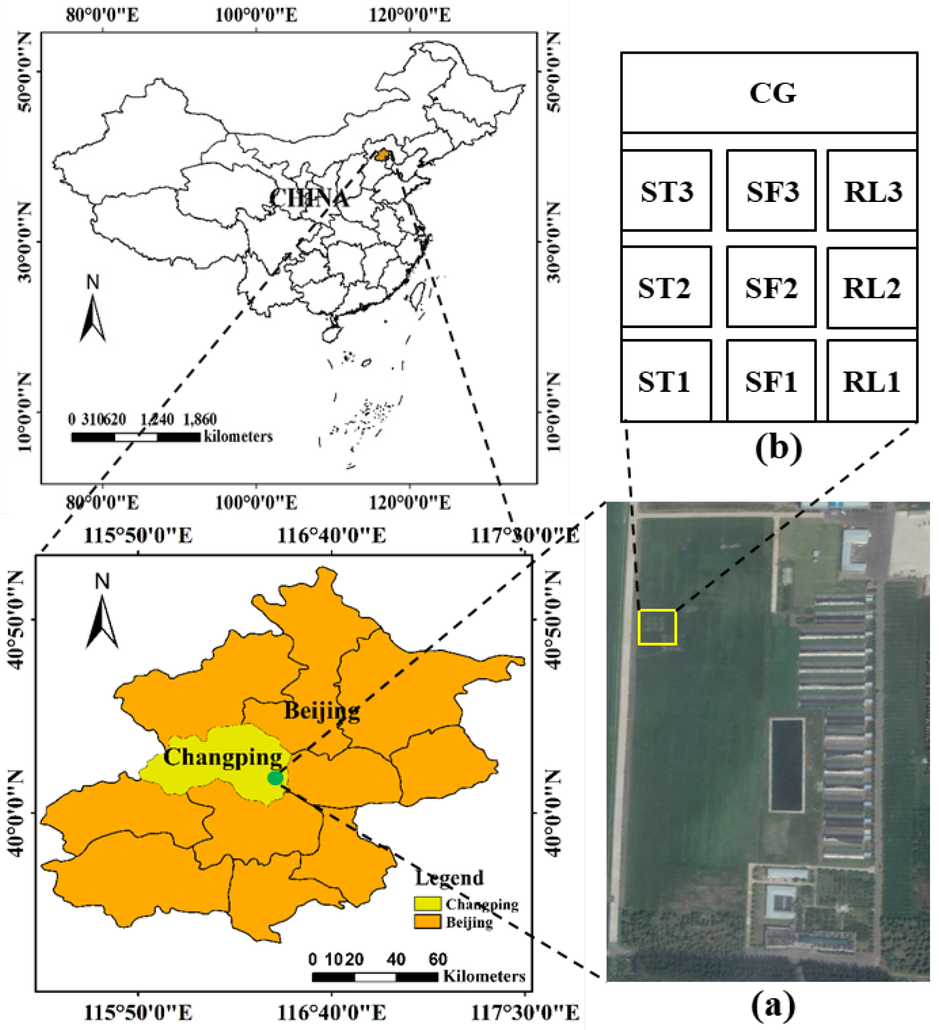
2.1. Study Area
2.2. Experimental Design
2.3. Data Acquisition
2.3.1. Flight Route Design
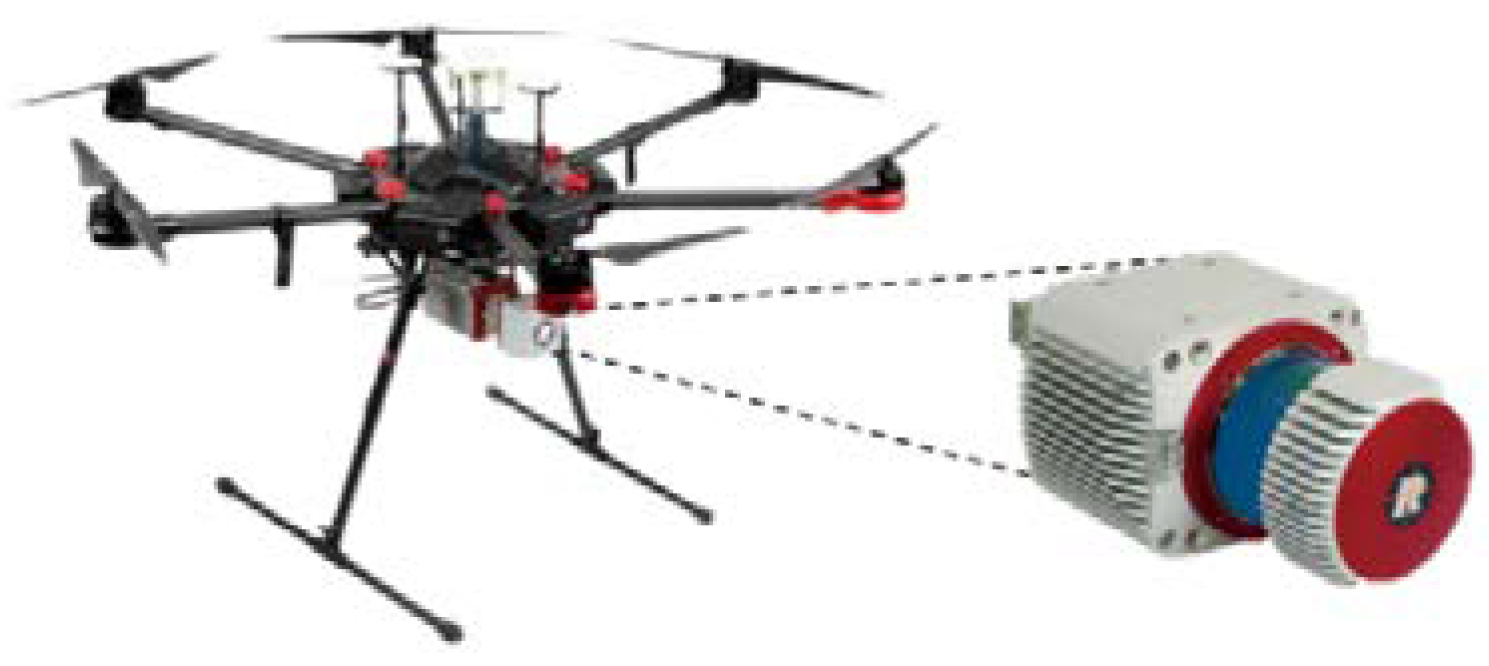
2.3.2. Sensor Parameter Settings
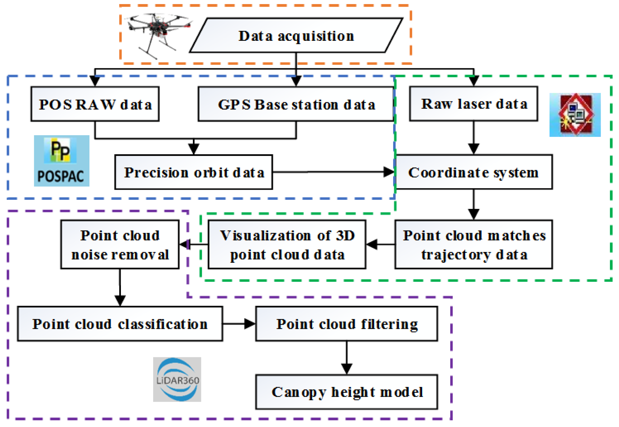
2.4. Data Processing
2.5. Canopy Height Model
2.6. Evaluation of Accuracy
3. Results and Analysis
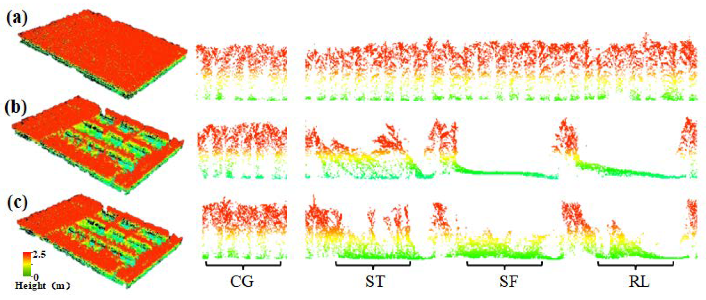
3.1. Profile Analysis of the Study Area
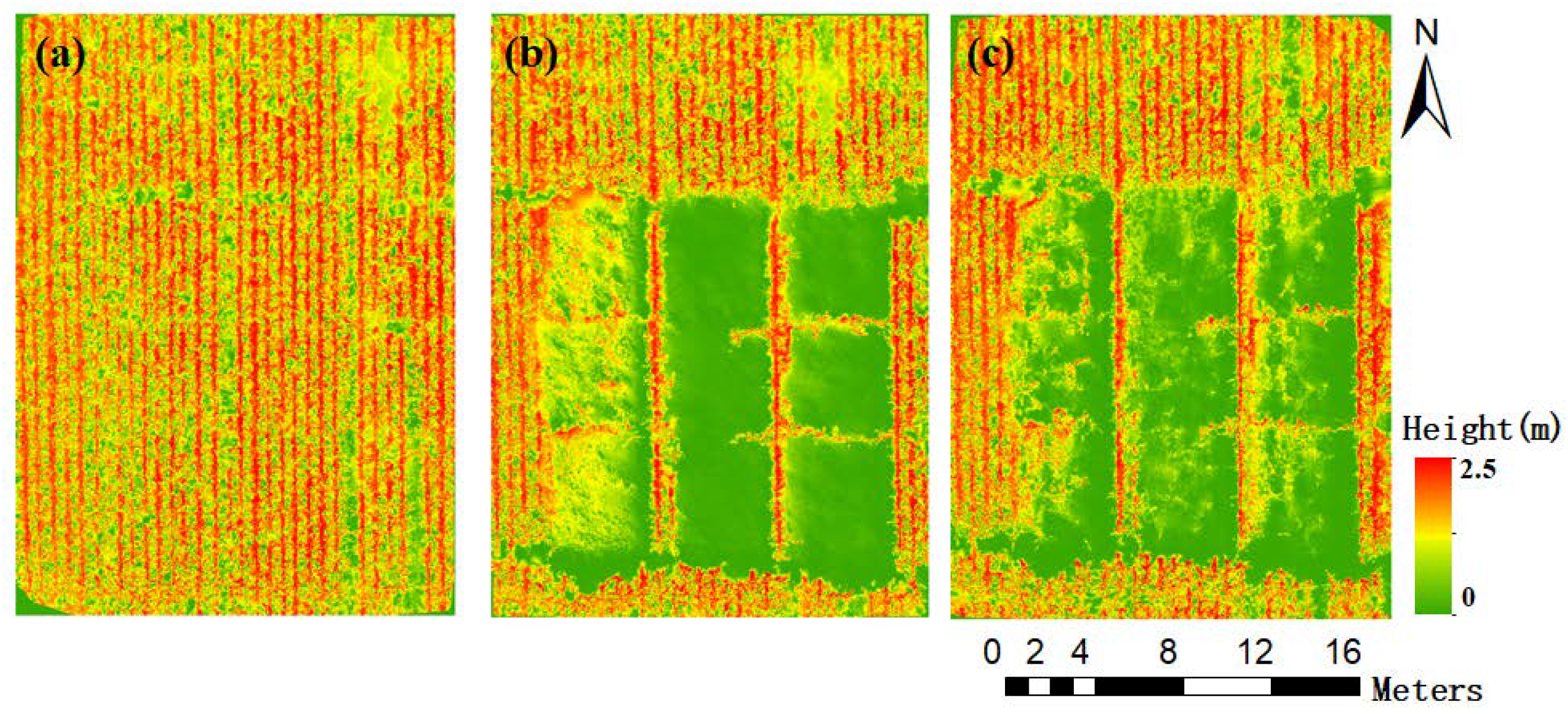
3.2. Canopy Height Change
3.3. Plant Height Verification
4. Discussion
5. Conclusions
- (1)
- Lodged maize has the ability to restore plant height, and canopy recovery is apparent, but the stem and root recovery is weak.
- (2)
- The UAV-LiDAR data can reflect the temporal changes of lodged maize plant height and the plant height restoration ability of different lodging types, and in terms of plant height restoration ability, RL > SF.
- (3)
- The UAV-LiDAR data can provide accurate estimated of lodged maize plant height. The plant height estimated accuracy parameters were R2 = 0.964, RMSE = 0.127, and nRMSE = 7.449%.
Author Contributions
Funding
Conflicts of Interest
References
- National Bureau of Statistics of China. Announcement on Grain Production in 2019. Available online: http://www.stats.gov.cn/tjsj/zxfb/201912/t20191206_1715827.html (accessed on 6 January 2020).
- Gastineau, G.; Soden, B.J. Model projected changes of extreme wind events in response to global warming. Geophys. Res. Lett. 2009, 36, 92–103. [Google Scholar] [CrossRef]
- Acorsi, M.G.; Martello, M.; Angnes, G. Identification of maize lodging: A case study using a remotely piloted aircraft system. Eng. Agric. 2019, 39, 66–73. [Google Scholar] [CrossRef]
- Islam, M.S.; Peng, S.; Visperas, R.M.; Ereful, N.; Bhuiya, M.S.U.; Julfiquar, A.W. Lodging-related morphological traits of hybrid rice in a tropical irrigated ecosystem. Field Crop. Res. 2007, 101, 240–248. [Google Scholar] [CrossRef]
- Berry, P.M.; Sterling, M.; Spink, J.H.; Baker, C.J.; Ennos, A.R. Understanding and reducing lodging in cereals. Adv. Agron. 2004, 84, 217. [Google Scholar]
- Kang, M.S.; Din, A.K.; Zhang, Y.; Magari, R. Combining ability for rind puncture resistance in maize. Crop Sci. 1999, 39, 368–371. [Google Scholar] [CrossRef]
- Elmore, R. Mid- to Late-Season Lodging. Iowa State University Extension and Outreach. Available online: http://crops.extension.iastate.edu/corn/production/management/mid/silking.html (accessed on 6 January 2020).
- Wen, W.L.; Gu, S.H.; Xiao, B.X.; Wang, C.Y.; Wang, J.L.; Ma, L.M.; Wang, Y.J.; Lu, X.J.; Yu, Z.T.; Zhang, Y.; et al. In situ evaluation of stalk lodging resistance for different maize (Zea mays L.) cultivars using a mobile wind machine. Plant Methods 2019, 15, 96. [Google Scholar] [CrossRef]
- Mi, C.Q.; Zhang, X.D.; Li, S.M.; Yang, J.Y.; Zhu, D.H.; Yang, Y. Assessment of environment lodging stress for maize using fuzzy synthetic evaluation. Math. Comput. Model. 2011, 54, 1053–1060. [Google Scholar] [CrossRef]
- Xue, J.; Gou, L.; Zhao, Y.S.; Yao, M.N.; Yao, H.S.; Tian, J.S.; Zhang, W.F. Effects of light intensity within the canopy on maize lodging. Field Crop. Res. 2016, 188, 133–141. [Google Scholar] [CrossRef]
- Li, G.; Zhang, L.Y.; Song, C.Y.; Peng, M.M.; Zhang, Y.; Han, W.T. Extraction Method of Wheat Lodging Information Based on Multi-temporal UAV Remote Sensing Data. Trans. Chin. Soc. Agric. Mach. 2019, 50, 211–220. [Google Scholar]
- Wang, J.J.; Ge, H.; Dai, Q.G.; Ahmad, I.; Dai, Q.X.; Zhou, G.S.; Qin, M.R.; Gu, C.H. Unsupervised discrimination between lodged and non-lodged winter wheat: A case study using a low-cost unmanned aerial vehicle. Int. J. Remote Sens. 2018, 39, 2079–2088. [Google Scholar] [CrossRef]
- Wu, S.; Liu, J.; Wang, L.; Zhou, Q. Study on yield assessment of lodging winter wheat based on image manipulation and hyperspectral analysis. Chin. J. Agric. Resour. Reg. Plan. 2013, 01, 41–48. [Google Scholar]
- Yang, M.D.; Huang, K.S.; Kuo, Y.H.; Tsai, H.P.; Lin, L.M. Spatial and Spectral Hybrid Image Classification for Rice Lodging Assessment through UAV Imagery. Remote Sens. 2017, 9, 583. [Google Scholar] [CrossRef]
- Zhang, J.C.; Gu, X.H.; Wang, J.H.; Huang, W.J.; Dong, Y.Y.; Luo, J.H. Evaluating maize grain quality by continuous wavelet analysis under normal and lodging circumstances. Sens. Lett. 2012, 10, 580–585. [Google Scholar] [CrossRef]
- Shu, M.Y.; Gu, X.H.; Sun, L.; Zhu, J.S.; Yang, G.J.; Wang, Y.C. Analysis of effect and spectral response of lodging stress on the ratio of visible stem, leaf and ear in winter wheat. Trans. Chin. Soc. Agric. Eng. 2019, 350, 168–174. [Google Scholar]
- Han, L.; Yang, G.J.; Feng, H.K.; Zhou, C.Q.; Yang, H.; Xu, B.; Li, Z.H.; Yang, X.D. Quantitative identification of maize lodging-causing feature factors using unmanned aerial vehicle images and a nomogram computation. Remote Sens. 2018, 10, 1528. [Google Scholar] [CrossRef]
- Singh, D.; Wang, X.; Kumar, U.; Gao, L.L.; Noor, M.; Imtiaz, M.; Singh, R.P.; Poland, J. High-Throughput Phenotyping Enabled Genetic Dissection of Crop Lodging in Wheat. Front. Plant Sci. 2019, 10, 394. [Google Scholar] [CrossRef] [PubMed]
- Liu, L.Y.; Wang, J.H.; Song, X.Y.; Li, C.J.; Huang, W.J.; Zhao, C.J. The Canopy Spectral Features and Remote Sensing of Wheat Lodging. Chin. J. Remote Sens. 2005, 9, 323–327. [Google Scholar]
- Liu, T.; Li, R.; Zhong, X.C.; Jiang, M.; Jin, X.L.; Zhou, P.; Liu, S.P.; Sun, C.M.; Guo, W.S. Estimates of rice lodging using indices derived from UAV visible and thermal infrared images. Agric. For. Meteorol. 2018, 252, 144–154. [Google Scholar] [CrossRef]
- Han, D.; Yang, H.; Yang, G.J.; Qiu, C.X. Monitoring model of corn lodging based on sentinel-1 radar image. In Proceedings of the 2017 SAR in Big Data Era: Models, Methods and Applications (BIGSARDATA) IEEE, Beijing, China, 13–14 November 2017; pp. 1–5. [Google Scholar] [CrossRef]
- Shu, M.Y.; Zhou, L.F.; Gu, X.H.; Ma, Y.T.; Sun, Q.; Yang, G.J.; Zhou, C.Q. Monitoring of maize lodging using multi-temporal Sentinel-1 SAR data. Adv. Space Res. 2020, 65, 470–480. [Google Scholar] [CrossRef]
- Sankaran, S.; Mishra, A.; Ehsani, R.; Davis, C. A review of advanced techniques for detecting plant diseases. Comput. Electron. Agric. 2010, 72, 1–13. [Google Scholar] [CrossRef]
- Schaepman, M.E.; Ustin, S.L.; Plaza, A.J.; Painter, T.H.; Verrelst, J.; Liang, S. Earth system science related imaging spectroscopy-An assessment. Remote Sens. Environ. 2009, 113, 123–137. [Google Scholar] [CrossRef]
- Traglia, F.D.; Ciampalini, A.; Pezzo, G.; Battaglia, M. Synthetic aperture radar and natural hazards: Applications and outlooks. Front. Earth Sci. 2019, 7, 7. [Google Scholar] [CrossRef]
- Yang, H.; Chen, E.X.; Li, Z.Y.; Zhao, C.J.; Yang, G.J.; Stefano, P.; Raffaele, C.; Zhao, L. Wheat lodging monitoring using polarimetric index from RADARSAT-2 data. Int. J. Appl. Earth Obs. Geoinf. 2015, 34, 157–166. [Google Scholar] [CrossRef]
- Chauhan, S.; Darvishzadeh, R.; Boschetti, M.; Nelson, A. Estimation of crop angle of inclination for lodged wheat using multi-sensor SAR data. Remote Sens. Environ. 2020, 236, 111488. [Google Scholar] [CrossRef]
- Sugandh, C.; Roshanak, D.; Mirco, B.; Monica, P.; Andy, N. Remote sensing-based crop lodging assessment: Current status and perspectives. ISPRS J. Photogramm. Remote Sens. 2019, 151, 124–140. [Google Scholar]
- Malambo, L.; Popescu, S.C.; Murray, S.C.; Putman, E.; Pugh, N.A.; Horne, D.W.; Richardson, G.; Sheridan, R.; Rooney, W.L.; Avant, R.; et al. Multitemporal field-based plant height estimation using 3D point clouds generated from small unmanned aerial systems high-resolution imagery. Int. J. Appl. Earth Obs. Geoinf. 2018, 64, 31–42. [Google Scholar] [CrossRef]
- Araus, J.L.; Jose, L.; Cairns, J.E. Field high-throughput phenotyping: The new crop breeding frontier. Trends Plant Sci. 2014, 19, 52–61. [Google Scholar] [CrossRef]
- Aasen, H.; Burkart, A.; Bolten, A.; Bareth, G. Generating 3D hyperspectral information with lightweight UAV snapshot cameras for vegetation monitoring: From camera calibration to quality assurance. ISPRS J. Photogramm. Remote Sens. 2015, 108, 245–259. [Google Scholar] [CrossRef]
- Guo, T.; Fang, Y.; Cheng, T.; Tian, Y.C.; Zhu, Y.; Chen, Q.; Qiu, X.L.; Yao, X. Detection of wheat height using optimized multi-scan mode of LiDAR during the entire growth stages. Comput. Electron. Agric. 2019, 165, 104959. [Google Scholar] [CrossRef]
- Chung, C.H.; Wang, C.H.; Hsieh, H.C.; Huang, C.Y. Comparison of forest canopy height profiles in a mountainous region of Taiwan derived from airborne LiDAR and unmanned aerial vehicle imagery. GISci. Remote Sens. 2019, 56, 1289–1304. [Google Scholar] [CrossRef]
- Nora, T.; Helge, A.; George, B. Fusion of plant height and vegetation indices for the estimation of barley biomass. Remote Sens. 2015, 7, 11449–11480. [Google Scholar]
- Lin, Y. LiDAR: An important tool for next-generation phenotyping technology of high potential for plant phenomics. Comput. Electron. Agric. 2015, 119, 61–73. [Google Scholar] [CrossRef]
- Simon, M.; Fred, B.; Benoitde, S.; Samuel, T.; Dan, D.; Stephane, J.; Matthieu, H.; Gallian, C.; Alexis, C. High-throughput phenotyping of plant height: Comparing unmanned aerial vehicles and ground LiDAR Estimates. Front. Plant Sci. 2017, 8, 2002. [Google Scholar]
- Crommelinck, S.; Höfle, B. Simulating an autonomously operating low-cost static terrestrial LiDAR for multitemporal maize crop height measurements. Remote Sens. 2016, 8, 205. [Google Scholar] [CrossRef]
- Jimenez-Berni, J.A.; Deery, D.M.; Pablo, R.L.; Condon, A.G.; Rebetzke, G.J.; James, R.A.; Bovill, W.D.; Furbank, R.T.; Sirault, X.R.R. High throughput determination of plant height, ground cover, and above-ground biomass in wheat with LiDAR. Front. Plant Sci. 2018, 9, 237. [Google Scholar] [CrossRef]
- Tilly, N.; Hoffmeister, D.; Cao, Q.; Huang, S.; Bareth, G. Multitemporal crop surface models: Accurate plant height measurement and biomass estimation with terrestrial laser scanning in paddy rice. J. Appl. Remote Sens. 2014, 8, 083671. [Google Scholar] [CrossRef]
- Jordi, L.; Emilio, G.; Jordi, L.; Antonio, M.F.; Montserrat, G. Testing the suitability of a terrestrial 2D LiDAR scanner for canopy characterization of greenhouse tomato crops. Sensors 2016, 16, 1435. [Google Scholar]
- Sun, S.P.; Li, C.Y.; Paterson, A.H. In-Field high-throughput phenotyping of cotton plant height using LiDAR. Remote Sens. 2017, 9, 377. [Google Scholar] [CrossRef]
- Song, X.Y.; Yang, G.J.; Yang, C.H.; Wang, J.H.; Cui, B. Spatial variability analysis of within-field winter wheat nitrogen and grain quality using canopy fluorescence sensor measurements. Remote Sens. 2017, 9, 237. [Google Scholar] [CrossRef]
- Zhu, Y.H.; Zhao, C.J.; Yang, H.; Yang, G.J.; Han, L.; Li, Z.H.; Feng, H.K.; Xu, B.; Wu, J.T.; Lei, L. Estimation of maize above-ground biomass based on stem-leaf separation strategy integrated with LiDAR and optical remote sensing data. PeerJ. 2019, 7, e7593. [Google Scholar] [CrossRef]
- Guo, P.; Wu, F.D.; Dai, J.G.; Zhao, Q.Z. Estimation of vegetation height in farmland region based on airborne LiDAR data. Arid Land Geogr. 2017, 40, 1241–1247. [Google Scholar]
- Gan, P.; Dong, Y.S.; Sun, L.; Yang, G.J.; Li, Z.H.; Yang, F.; Wang, L.Z.; Wang, J.W. Evaluation of Maize Waterlogging Disaster Using UAV LiDAR Data. Chin. Agric. Sci. 2017, 50, 2983–2992. [Google Scholar]
- Lei, L.; Qiu, C.X.; Li, Z.H.; Han, D.; Han, L.; Zhu, Y.H.; Wu, J.T.; Xu, B.; Feng, H.K.; Yang, H.; et al. Effect of leaf occlusion on leaf area index inversion of maize using UAV–LiDAR data. Remote Sens. 2019, 11, 1067. [Google Scholar] [CrossRef]
- Quan, Y.N.; Song, J.F.; Guo, X.; Miao, Q.G.; Yang, Y. Filtering LiDAR data based on adjacent triangle of triangulated irregular network. Multimed. Tools Appl. 2017, 76, 11051–11063. [Google Scholar] [CrossRef]
- Chu, T.X.; Starek, M.J.; Brewer, M.J.; Murray, S.C.; Pruter, L.S. Assessing Lodging Severity over an Experimental Maize (Zea mays L.) Field Using UAS Images. Remote Sens. 2017, 9, 923. [Google Scholar] [CrossRef]
- Cui, Y.K.; Zhao, K.G.; Fan, W.J.; Xu, X.R. Retrieving crop fractional cover and LAI based on airborne LiDAR data. Chin. J. Remote Sens. 2011, 15, 1276–1288. [Google Scholar]
- Soothar, R.K.; Zhang, W.Y.; Zhang, Y.Q. Evaluating the performance of SALTMED model under alternate irrigation using saline andfresh water strategies to winter wheat in the North China Plain. Environ. Sci. Pollut. Res. 2019, 26, 34499. [Google Scholar] [CrossRef]
- Timsina, J.; Humphreys, E. Performance of CERES-Rice and CERES-Wheat Models in Rice—Wheat Systems: A review. Agric. Syst. 2006, 90, 5–31. [Google Scholar] [CrossRef]
- Wang, X.; Singh, D.; Marla, S.; Morris, G.; Poland, J. Field-based high-throughput phenotyping of plant height in sorghum using different sensing technologies. Plant Methods 2018, 14, 53. [Google Scholar] [CrossRef]
- Bendig, J.; Yu, K.; Aasen, H.; Bolten, A.; Bennert, S.; Broscheit, J.; Gnyp, M.L.; Bareth, G. Combining UAV-based plant height from crop surface models, visible, and near infrared vegetation indices for biomass monitoring in barley. Int. J. Appl. Earth Obs. Geoinf. 2015, 39, 79–87. [Google Scholar] [CrossRef]
- Jonathan, L.; Marc, P.D.; Stéphanie, B.; Philippe, L. A photogrammetric workflow for the creation of a forest canopy height model from small unmanned aerial system imagery. Forests 2013, 4, 922–944. [Google Scholar]
- Grenzdörffer, G.J. Crop height determination with UAS point clouds. ISPRS Int. Arch. Photogramm. Remote. Sens. Spat. Inf. Sci. 2014, XL-1, 135–140. [Google Scholar]
- Tetsuji, O.; Miyuki, O.; Katsuto, S.; Tsuyoshi, K.; Nobuya, M.; Shigejiro, Y.; Gen, T.; Yasumasa, H.; Naoyuki, F.; Takio, S.; et al. Aboveground biomass estimation using structure, from motion approach with aerial photographs in a, seasonal tropical forest. Forests 2015, 6, 3882–3898. [Google Scholar]
- Khanna, R.; Martin, M.; Pfeifer, J.; Liebisch, F.; Siegwart, R. Beyond Point Clouds -3D Mapping and Field Parameter Measurements using UAVs. In Proceedings of the 2015 IEEE 20th Conference on Emerging Technologies & Factory Automation (ETFA), Luxembourg, 8–11 September 2015; pp. 1–4. [Google Scholar] [CrossRef]
- Esther, G.; Astor, T.; Wachendorf, M. Biomass Prediction of Heterogeneous Temperate Grasslands Using an SFM Approach Based on UAV Imaging. Agronomy 2019, 9, 54. [Google Scholar]
- Deery, D.; Jimenez-Berni, J.; Jones, H.; Sirault, X.; Furbank, R. Proximal remote sensing buggies and potential applications for field-based phenotyping. Agronomy 2014, 4, 349–379. [Google Scholar] [CrossRef]
- Virlet, N.; Sabermanesh, K.; Sadeghi-Tehran, P.; Hawkesford, M.J. Field Scanalyzer: An automated robotic field phenotyping platform for detailed crop monitoring. Funct. Plant Biol. 2017, 44, 143. [Google Scholar] [CrossRef]
- Niu, Y.X.; Zhang, L.Y.; Zhang, H.H.; Han, W.T.; Peng, X.S. Estimating above-ground biomass of maize using features derived from UAV-based RGB imagery. Remote Sens. 2019, 11, 1261. [Google Scholar] [CrossRef]
- Walter, J.D.C.; James, E.; Mcdonald, G.; Kuchel, H. Estimating biomass and canopy height with LiDAR for field crop breeding. Front. Plant Sci. 2019, 10, 1145. [Google Scholar] [CrossRef]
- Easson, D.L.; White, E.M.; Pickles, S.J. The effects of weather, seed rate and cultivar on lodging and yield in winter wheat. J. Agric. Sci. 1993, 121, 145–156. [Google Scholar] [CrossRef]
- Li, S.Y.; Wang, Y.X.; Hu, C.D.; Yan, Y. Effects of strong wind lodging at pre- and post-tasseling stages on growth and yield of summer maize. Chin. J. Appl. Ecol. 2015, 26, 2405–2413. [Google Scholar]

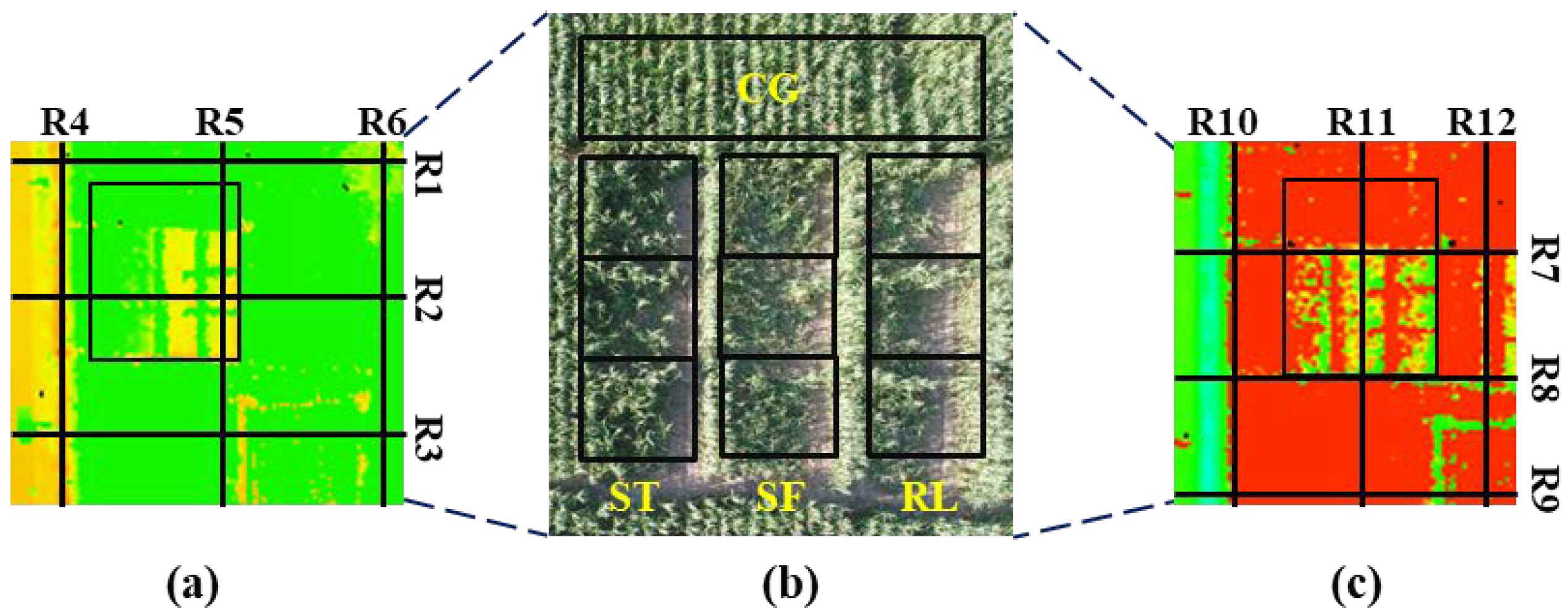


| Direction | Route | Point Cloud Density (pts/m2) | Direction | Route | Point Cloud Density (pts/m2) |
|---|---|---|---|---|---|
| EW | R1 | 112 | NS | R4 | 228 |
| R2 | 280 | R5 | 496 | ||
| R3 | 529 | R6 | 417 | ||
| R7 | 570 | R10 | 321 | ||
| R8 | 285 | R11 | 466 | ||
| R9 | 200 | R12 | 366 |
| Parameter | Value |
|---|---|
| Wavelength (nm) | 1550 |
| Flying speed (m·s−1) | 3 |
| Flying height (m) | 15 |
| Area coverage routes (lines) | 6 |
| Scan overlap rate (%) | 40 |
| Pulse frequency (kHz) | 550 |
| Beam divergence angle (mrad) | 0.5 |
© 2020 by the authors. Licensee MDPI, Basel, Switzerland. This article is an open access article distributed under the terms and conditions of the Creative Commons Attribution (CC BY) license (http://creativecommons.org/licenses/by/4.0/).
Share and Cite
Zhou, L.; Gu, X.; Cheng, S.; Yang, G.; Shu, M.; Sun, Q. Analysis of Plant Height Changes of Lodged Maize Using UAV-LiDAR Data. Agriculture 2020, 10, 146. https://doi.org/10.3390/agriculture10050146
Zhou L, Gu X, Cheng S, Yang G, Shu M, Sun Q. Analysis of Plant Height Changes of Lodged Maize Using UAV-LiDAR Data. Agriculture. 2020; 10(5):146. https://doi.org/10.3390/agriculture10050146
Chicago/Turabian StyleZhou, Longfei, Xiaohe Gu, Shu Cheng, Guijun Yang, Meiyan Shu, and Qian Sun. 2020. "Analysis of Plant Height Changes of Lodged Maize Using UAV-LiDAR Data" Agriculture 10, no. 5: 146. https://doi.org/10.3390/agriculture10050146
APA StyleZhou, L., Gu, X., Cheng, S., Yang, G., Shu, M., & Sun, Q. (2020). Analysis of Plant Height Changes of Lodged Maize Using UAV-LiDAR Data. Agriculture, 10(5), 146. https://doi.org/10.3390/agriculture10050146


