Design Criteria for Planning the Agricultural Rainwater Harvesting Systems: A Review


Abstract
1. Introduction
2. Rainwater Harvesting Structures
3. Discussion
4. Conclusions
Author Contributions
Funding
Acknowledgments
Conflicts of Interest
References
- Medeiros, A.S.; Wood, P.; Wesche, S.D.; Bakaic, M.; Peters, J.F. Water security for northern peoples: Review of threats to Arctic freshwater systems in Nunavut, Canada. Reg. Environ. Chang. 2017, 17, 635–647. [Google Scholar] [CrossRef]
- Koehler, A. Water use in LCA: Managing the planet’s freshwater resources. Int. J. Life Cycle Assess. 2008, 13, 451–455. [Google Scholar] [CrossRef]
- Vörösmarty, C.J.; McIntyre, P.B.; Gessner, M.O.; Dudgeon, D.; Prusevich, A.; Green, P.; Glidden, S.; Bunn, S.E.; Sullivan, C.A.; Liermann, C.R.; et al. Global threats to human water security and river biodiversity. Nature 2010, 467, 555–561. [Google Scholar] [CrossRef] [PubMed]
- Petersen-Perlman, J.D.; Veilleux, J.C.; Wolf, A.T. International water conflict and cooperation: Challenges and opportunities. Water Int. 2017, 42, 105–120. [Google Scholar] [CrossRef]
- Sainz Santamaría, J.; Becerra, M. Los conflictos por el agua en México. Gac. Ecol. 2002, 67, 61–68. [Google Scholar]
- Dos Santos, S.; Adams, E.A.; Neville, G.; Wada, Y.; de Sherbinin, A.; Mullin Bernhardt, E.; Adamo, S.B. Urban growth and water access in sub-Saharan Africa: Progress, challenges, and emerging research directions. Sci. Total Environ. 2017, 607, 497–508. [Google Scholar] [CrossRef]
- Hashim, H.; Hudzori, A.; Yusop, Z.; Ho, W.S. Simulation based programming for optimization of large-scale rainwater harvesting system: Malaysia case study. Resour. Conserv. Recycl. 2013, 80, 1–9. [Google Scholar] [CrossRef]
- Garrote, L. Managing Water Resources to Adapt to Climate Change: Facing Uncertainty and Scarcity in a Changing Context. Water Resour Manag. 2017, 31, 2951–2963. [Google Scholar] [CrossRef]
- Miranda, J.D. Cambio climático y patrones de precipitación: Efecto sobre las comunidades vegetales semiáridas. Ecosistemas 2008, 17, 161–165. [Google Scholar]
- Allen, M.R.; Ingram, W.J. Constraints on future changes in climate and the hydrologic cycle. Nature 2002, 419, 224–232. [Google Scholar] [CrossRef]
- Kristvik, E.; Muthanna, T.M.; Alfredsen, K. Assessment of future water availability under climate change, considering scenarios for population growth and ageing infrastructure. J. Water Clim. Chang. 2019, 10, 1–12. [Google Scholar] [CrossRef]
- Dimri, A.P.; Thayyen, R.J.; Kibler, K.; Stanton, A.; Jain, S.K.; Tullos, D.; Singh, V.P. A review of atmospheric and land surface processes with emphasis on flood generation in the Southern Himalayan rivers. Sci. Total Environ. 2016, 556, 98–115. [Google Scholar] [CrossRef] [PubMed]
- Rigo, T.; Llasat, M.C. A methodology for the classification of convective structures using meteorological radar: Application to heavy rainfall events on the Mediterranean coast of the Iberian Peninsula. Nat. Hazards Earth Syst. Sci. 2004, 4, 59–68. [Google Scholar] [CrossRef]
- Domínguez-Mora, R.; Arganis-Juárez, M.L.; Mendoza-Reséndiz, A.; Carrizosa-Elizondo, E.; EchavarrÍa-Soto, B. Storms generator method that preserves their historical statistical characteristics. Application to Mexico City basin daily rainfall fields. Atmósfera 2013, 26, 27–43. [Google Scholar]
- De Paola, F.; Giugni, M.; Cornacchia, M.E.; Libralato, G.; Lofrano, G. A rainfall data analysis for the archeological drawing of the Augustan aqueduct route. J. Cult. Herit. 2016, 19, 395–401. [Google Scholar] [CrossRef]
- Köppen, W. Klassifikation der Klimate nach Temperatur, Niederschlag und Jahresablauf [Classification of climates according to temperature, precipitation and seasonal cycle]. Petermanns Geogr. Mitt. 1918, 64, 193–203. [Google Scholar]
- Appan, A. A dual-mode system for harnessing roofwater for non-potable uses. Urban Water 2000, 1, 317–321. [Google Scholar] [CrossRef]
- Gikas, G.D.; Tsihrintzis, V.A. Assessment of water quality of first-flush roof runoff and harvested rainwater. J. Hydrol. 2012, 466, 115–126. [Google Scholar] [CrossRef]
- Vohland, K.; Barry, B. A review of in situ rainwater harvesting (RWH) practices modifying landscape functions in African drylands. Agric. Ecosyst. Environ. 2009, 131, 119–127. [Google Scholar] [CrossRef]
- Nachshon, U.; Netzer, L.; Livshitz, Y. Land cover properties and rain water harvesting in urban environments. Sustain. Cities Soc. 2016, 27, 398–406. [Google Scholar] [CrossRef]
- Oweis, T.; Hachum, A. Water harvesting and supplemental irrigation for improved water productivity of dry farming systems in West Asia and North Africa. Agric. Water Manag. 2006, 80, 57–73. [Google Scholar] [CrossRef]
- Agriculture Organization of the United Nations; Soil Resources, Conservation Service, Agriculture Organization of the United Nations; Land, Water Development Division. Soil Tillage in Africa: Needs and Challenges; Food & Agriculture Organization: Rome, Italy, 1993. [Google Scholar]
- Salem, H.M.; Valero, C.; Muñoz, M.Á.; Gil-Rodríguez, M. Effect of integrated reservoir tillage for in-situ rainwater harvesting and other tillage practices on soil physical properties. Soil Tillage Res. 2015, 151, 50–60. [Google Scholar] [CrossRef]
- Pacey, A.; Cullis, A. Rainwater Harvesting: The Collection of Rainfall and Runoff in Rural Areas; Intermediate Technology Publications: London, UK, 1986. [Google Scholar]
- Mekonnen, M.; Melesse, A.M.; Keesstra, S.D. Spatial Runoff Estimation and Mapping of Potential Water Harvesting Sites: A GIS and Remote Sensing Perspective, Northwest Ethiopia. In Landscape Dynamics, Soils and Hydrological Processes in Varied Climates; Melesse, A.M., Abtew, W., Eds.; Springer: Cham, Switzerland, 2016; pp. 565–584. ISBN 978-3-319-18786-0. [Google Scholar]
- Domènech, L.; Saurí, D. A comparative appraisal of the use of rainwater harvesting in single and multi-family buildings of the Metropolitan Area of Barcelona (Spain): Social experience, drinking water savings and economic costs. J. Clean. Prod. 2011, 19, 598–608. [Google Scholar] [CrossRef]
- Zeng, B.; Tan, H.; Wu, L. A New Approach to Urban Rainwater Management. J. China Univ. Min. Technol. 2007, 17, 82–84. [Google Scholar] [CrossRef]
- Basinger, M.; Montalto, F.; Lall, U. A rainwater harvesting system reliability model based on nonparametric stochastic rainfall generator. J. Hydrol. 2010, 392, 105–118. [Google Scholar] [CrossRef]
- Chilton, J.C.; Maidment, G.G.; Marriott, D.; Francis, A.; Tobias, G. Case study of a rainwater recovery system in a commercial building with a large roof. Urban Water 2000, 1, 345–354. [Google Scholar] [CrossRef]
- Gurung, T.R.; Sharma, A. Communal rainwater tank systems design and economies of scale. J. Clean. Prod. 2014, 67, 26–36. [Google Scholar] [CrossRef]
- Rashidi Mehrabadi, M.H.; Saghafian, B.; Haghighi Fashi, F. Assessment of residential rainwater harvesting efficiency for meeting non-potable water demands in three climate conditions. Resour. Conserv. Recycl. 2013, 73, 86–93. [Google Scholar] [CrossRef]
- Lara, J.; Torres, A.; Campos, M.; Duarte, L.; Echeverri, J.; Villegas, P. Using Rainwater for Irrigation, Hard Surface & Façade Cleaning at Pontificia Universidad Javeriana’s. Pontif. Univ. Javer. 2007, 11, 193–202. [Google Scholar]
- Karpouzoglou, T.; Barron, J. A global and regional perspective of rainwater harvesting in sub-Saharan Africa’s rainfed farming systems. Phys. Chem. Earth A B C 2014, 72, 43–53. [Google Scholar] [CrossRef]
- Napoli, M.; Cecchi, S.; Orlandini, S.; Zanchi, C.A. Determining potential rainwater harvesting sites using a continuous runoff potential accounting procedure and GIS techniques in central Italy. Agric. Water Manag. 2014, 141, 55–65. [Google Scholar] [CrossRef]
- de Simon, E.; Ripoll, M.A.; Bocio, I.; Navarro, F.B.; Gallego, E. Aprovechamiento de escorrentías superficiales, mediante la formación de microcuencas, en repoblaciones de zonas semiáridas. In Proceedings of the III Congreso Forestal Español, Sociedad Española de Ciencias Forestales, Granada, Spain, 25–28 September 2001; pp. 1–5. [Google Scholar]
- Taddele Dile, Y.; Karlberg, L.; Daggupati, P.; Srinivasan, R.; Wiberg, D.; Rockström, J. Assessing the implications of water harvesting intensification on upstream-downstream ecosystem services: A case study in the Lake Tana basin. Sci. Total Environ. 2016, 542, 22–35. [Google Scholar] [CrossRef] [PubMed]
- Dobrowsky, P.H.; Carstens, M.; De Villiers, J.; Cloete, T.E.; Khan, W. Efficiency of a closed-coupled solar pasteurization system in treating roof harvested rainwater. Sci. Total Environ. 2015, 536, 206–214. [Google Scholar] [CrossRef] [PubMed]
- Farreny, R.; Morales-Pinzón, T.; Guisasola, A.; Tayà, C.; Rieradevall, J.; Gabarrell, X. Roof selection for rainwater harvesting: Quantity and quality assessments in Spain. Water Res. 2011, 45, 3245–3254. [Google Scholar] [CrossRef] [PubMed]
- De Kwaadsteniet, M.; Dobrowsky, P.H.; Van Deventer, A.; Khan, W.; Cloete, T.E. Domestic rainwater harvesting: Microbial and chemical water quality and point-of-use treatment systems. Water Air Soil Pollut. 2013, 224, 1629. [Google Scholar] [CrossRef]
- Lee, J.Y.; Bak, G.; Han, M. Quality of roof-harvested rainwater—Comparison of different roofing materials. Environ. Pollut. 2012, 162, 422–429. [Google Scholar] [CrossRef]
- Leong, J.Y.C.; Chong, M.N.; Poh, P.E.; Hermawan, A.; Talei, A. Longitudinal assessment of rainwater quality under tropical climatic conditions in enabling effective rainwater harvesting and reuse schemes. J. Clean. Prod. 2017, 143, 64–75. [Google Scholar] [CrossRef]
- Nosrati, K. Identification of a water quality indicator for urban roof runoff. Sustain. Water Qual. Ecol. 2017, 9, 78–87. [Google Scholar] [CrossRef]
- Lee, M.; Kim, M.; Kim, Y.; Han, M. Consideration of rainwater quality parameters for drinking purposes: A case study in rural Vietnam. J. Environ. Manag. 2017, 200, 400–406. [Google Scholar] [CrossRef]
- Alamdari, N.; Sample, D.J.; Liu, J.; Ross, A. Assessing climate change impacts on the reliability of rainwater harvesting systems. Resour. Conserv. Recycl. 2018, 132, 178–189. [Google Scholar] [CrossRef]
- FAO. Feasibility Study of Rainwater Harvesting for Agriculture in the Caribbean Subregion; FAO: Rome, Italy, 2014. [Google Scholar]
- Oweis, T.; Hachum, A.; Kijne, J. Water Harvesting and Supplementary Irrigation for Improved Water Use Efficiency in Dry Areas; International Water Management Institute: Colombo, Sri Lanka, 1999; ISBN 9290903783. [Google Scholar]
- Oweis, T.; Prinz, D.; Hachum, A.Y. Rainwater Harvesting for Agriculture in the Dry Areas; CRC Press/Balkema, Taylor & Francis: London, UK, 2012; ISBN 0-415-62114-3. [Google Scholar]
- FAO. Strengthening Agricultural Water Efficiency and Productivity on African and Global Level; FAO: Rome, Italy, 2016; ISBN 978-92-5-109350-4. [Google Scholar]
- Critchley, W.; Siegert, K.; Chapman, C.; Finkel, M. Water Harvesting: A Manual for Design and Construction of Water Harvesting Schemes for Plant Production, 1st ed.; FAO: Rome, Italy, 1991; ISBN 978-3-905835-35-9. [Google Scholar]
- van Steenbergen, F.; Tuinhof, A.; van Beusekom, M. Managing the Water Buffer for Development and Climate Change Adaptation: Groundwater Recharge, Retention, Reuse and Rainwater Storage; s.n.: S.l.; Wageningen Academic Publishers: Wageningen, The Netherlands, 2010; ISBN 978-90-79658-03-9. [Google Scholar]
- Norton, L.D.; Chaudhari, K.; Flanagan, D. Erosion Control Using Soil Amendments and Other Low Cost Methods Prior to Establishment of Vegetation. In Proceedings of the 12th ISCO Conference, Beijing, China, 26–31 May 2002; Ministry of Water Resources, People’s Republic of China: Beijing, China, 2002; p. 6. [Google Scholar]
- Ventura, E., Jr.; Norton, D.; Ward, K.; López-Bautista, M.; Tapia-Naranjo, A. “In Situ” water harvesting for crop production in semiarid regions. In Proceedings of the XI IRCSA CONFERENCE, International Conference on Rainwater Catchmet Systems Association, Texcoco, Mexico, 22–26 September 2003; pp. 1–23. [Google Scholar]
- Gupta, K.K.; Deelstra, J.; Sharma, K.D. Estimation of water harvesting potential for a semiarid area using GIS and remote sensing. In Proceedings of the Rabat Symposium S3, Rabat, Morocco, 23 April–3 May 1997; IASH Public: Wallingford, UK; pp. 53–62. [Google Scholar]
- Srivastava, R.C. Methodology for design of water harvesting system for high rainfall areas. Agric. Water Manag. 2001, 47, 37–53. [Google Scholar] [CrossRef]
- Senay, G.B.; Verdin, J.P. Developing index maps of water-harvest potential in Africa. Appl. Eng. Agric. 2004, 20, 789–800. [Google Scholar] [CrossRef]
- De Winnaar, G.; Jewitt, G.P.W.; Horan, M. A GIS-based approach for identifying potential runoff harvesting sites in the Thukela River basin, South Africa. Phys. Chem. Earth 2007, 32, 1058–1067. [Google Scholar] [CrossRef]
- Forzieri, G.; Gardenti, M.; Caparrini, F.; Castelli, F. A methodology for the pre-selection of suitable sites for surface and underground small dams in arid areas: A case study in the region of Kidal, Mali. Phys. Chem. Earth 2008, 33, 74–85. [Google Scholar] [CrossRef]
- Roy, D.; Panda, S.N.; Panigrahi, B. Water balance simulation model for optimal sizing of on-farm reservoir in rainfed farming system. Comput. Electron. Agric. 2009, 65, 114–124. [Google Scholar] [CrossRef]
- Sturm, M.; Zimmermann, M.; Schütz, K.; Urban, W.; Hartung, H. Rainwater harvesting as an alternative water resource in rural sites in central northern Namibia. Phys. Chem. Earth A B C 2009, 34, 776–785. [Google Scholar] [CrossRef]
- Al-Daghastani, H.S. Water harvesting search in Ninevah governorate using remote sensing data. Iraqi J. Desert Stud. 2010, 2, 1–15. [Google Scholar]
- Salih, S.A.; Al-Tarif, A.S.M. Using of GIS spatial analyses to study the selected location for dam reservoir on Wadi Al-Jirnaf, West of Shirqat Area, Iraq. J. Geogr. Inf. Syst. 2012, 4, 117–127. [Google Scholar] [CrossRef]
- Ziadat, F.; Bruggeman, A.; Oweis, T.; Haddad, N.; Mazahreh, S.; Sartawi, W.; Syuof, M. A participatory GIS approach for assessing land suitability for rainwater harvesting in an arid rangeland environment. Arid Land Res. Manag. 2012, 26, 297–311. [Google Scholar] [CrossRef]
- Jayasuriya, N.; Navaratne, C.M.; Nandasiri Weerasignhe, K.D.; Nawarathna, B.; Adams, R. Roof runoff capture for home garden crop cultivation in Sri Lanka. J. Irrig. Drain. Eng. 2014, 140, 05014004. [Google Scholar] [CrossRef]
- Jabr, W.M.; El-Awar, F.A. Gis and analytic hierarchy process for siting water harvesting reservoirs. In Proceedings of the 24th Annual Esri International User Conference, San Diego, CA, USA, 9–13 August 2004; pp. 515–523. [Google Scholar]
- Mahmoud, S.H.; Tang, X. Monitoring prospective sites for rainwater harvesting and stormwater management in the United Kingdom using a GIS-based decision support system. Environ. Earth Sci. 2015, 73, 8621–8638. [Google Scholar] [CrossRef]
- Adham, A.; Riksen, M.; Ouessar, M.; Ritsema, C.J. A methodology to assess and evaluate rainwater harvesting techniques in (semi-) arid regions. Water 2016, 8, 198. [Google Scholar] [CrossRef]
- Sayl, K.N.; Muhammad, N.S.; Yaseen, Z.M.; El-shafie, A. Estimation the physical variables of rainwater harvesting system using integrated GIS-based remote sensing approach. Water Resour. Manag. 2016, 30, 3299–3313. [Google Scholar] [CrossRef]
- Mahmood, A.; Hossain, F. Feasibility of managed domestic rainwater harvesting in South Asian rural areas using remote sensing. Resour. Conserv. Recycl. 2017, 125, 157–168. [Google Scholar] [CrossRef]
- Terêncio, D.P.S.; Sanches Fernandes, L.F.; Cortes, R.M.V.; Pacheco, F.A.L. Improved framework model to allocate optimal rainwater harvesting sites in small watersheds for agro-forestry uses. J. Hydrol. 2017, 550, 318–330. [Google Scholar] [CrossRef]
- Terêncio, D.P.S.; Sanches Fernandes, L.F.; Cortes, R.M.V.; Moura, J.P.; Pacheco, F.A.L. Rainwater harvesting in catchments for agro-forestry uses: A study focused on the balance between sustainability values and storage capacity. Sci. Total Environ. 2018, 613, 1079–1092. [Google Scholar] [CrossRef]
- Grum, B.; Hessel, R.; Kessler, A.; Woldearegay, K.; Yazew, E.; Ritsema, C.; Geissen, V. A decision support approach for the selection and implementation of water harvesting techniques in arid and semi-arid regions. Agric. Water Manag. 2016, 173, 35–47. [Google Scholar] [CrossRef]
- Bhatnagar, P.R.; Srivastava, R.C.; Bhatnagar, V.K. Management of runoff stored in small tanks for transplanted rice production in the mid-hills of Northwest Himalaya. Agric. Water Manag. 1996, 30, 107–118. [Google Scholar] [CrossRef]
- Oweis, T.; Oberle, A.; Prinz, D. Determination of potential sites and methods for water harvesting in Central Syria. Adv. Geoecol. 1998, 31, 83–88. [Google Scholar]
- Schiettecatte, W.; Ouessar, M.; Gabriels, D.; Tanghe, S.; Heirman, S.; Abdelli, F. Impact of water harvesting techniques on soil and water conservation: A case study on a micro catchment in southeastern Tunisia. J. Arid Environ. 2005, 61, 297–313. [Google Scholar] [CrossRef]
- Ziadat, F.M.; Mazahreh, S.S.; Oweis, T.Y.; Bruggeman, A. A GIS-based approach for assessing water harvesting suitability in a Badia Benchmark Watershed in Jordan. In Proceedings of the 14th Internacional Soil Conservation Organization Conference (ISCO), Marrakech, Morocco, 14–19 May 2006; Volume 2006, pp. 1–4. [Google Scholar]
- Mbilinyi, B.P.; Tumbo, S.D.; Mahoo, H.F.; Mkiramwinyi, F.O. GIS-based decision support system for identifying potential sites for rainwater harvesting. Phys. Chem. Earth A B C 2007, 32, 1074–1081. [Google Scholar] [CrossRef]
- Al Ali, Y.; Touma, J.; Zante, P.; Nasri, S.; Albergel, J. Water and sediment balances of a contour bench terracing system in a semi-arid cultivated zone (El Gouazine, central Tunisia). Hydrol. Sci. J. 2008, 53, 883–892. [Google Scholar] [CrossRef]
- Bakir, M.; Xingnan, Z. GIS and remote sensing applications for rainwater harvesting in the syrian desert (al-badia). In Proceedings of the 12th International Water Technology Conference, Water Technology Association (WTA), Alexandria, Egypt, 27–30 March 2008; pp. 1–10. [Google Scholar]
- Al-Seekh, S.H.; Mohammad, A.G. The effect of water harvesting techniques on runoff, sedimentation, and soil properties. Environ. Manag. 2009, 44, 37–45. [Google Scholar] [CrossRef] [PubMed]
- Bekele Awulachew, S.; Lemperiere, P.; Tulu, T. Training Manual on Agricultural Water Management; ILRI Publications Unit: Addis Ababa, Ethiopia, 2009. [Google Scholar]
- Mechlia, N.B.; Oweis, T.; Masmoudi, M.; Khatteli, H.; Ouessar, M.; Sghaier, N.; Anane, M.; Sghaier, M. Assessment of Supplemental Irrigation and Water Harvesting Potential: Methodologies and Case Studies from Tunisia; ICARDA: Aleppo, Syria, 2009; ISBN 92-9127-222-1. [Google Scholar]
- Previati, M.; Bevilacqua, I.; Canone, D.; Ferraris, S.; Haverkamp, R. Evaluation of soil water storage efficiency for rainfall harvesting on hillslope micro-basins built using time domain reflectometry measurements. Agric. Water Manag. 2010, 97, 449–456. [Google Scholar] [CrossRef]
- Al-Shamiri, A.; Ziadat, F.M. Soil-landscape modeling and land suitability evaluation: The case of rainwater harvesting in a dry rangeland environment. Int. J. Appl. Earth Obs. Geoinf. 2012, 18, 157–164. [Google Scholar] [CrossRef]
- Krois, J.; Schulte, A. GIS-based multi-criteria evaluation to identify potential sites for soil and water conservation techniques in the Ronquillo watershed, northern Peru. Appl. Geogr. 2014, 51, 131–142. [Google Scholar] [CrossRef]
- Mahmoud, S.H.; Alazba, A.A. The potential of in situ rainwater harvesting in arid regions: Developing a methodology to identify suitable areas using GIS-based decision support system. Arab. J. Geosci. 2015, 8, 5167–5179. [Google Scholar] [CrossRef]
- Adham, A.; Wesseling, J.G.; Riksen, M.; Ouessar, M.; Ritsema, C.J. A water harvesting model for optimizing rainwater harvesting in the wadi Oum Zessar watershed, Tunisia. Agric. Water Manag. 2016, 176, 191–202. [Google Scholar] [CrossRef]
- Kahinda, J.M.; Lillie ES, B.; Taigbenu, A.E.; Taute, M.; Boroto, R.J. Developing suitability maps for rainwater harvesting in South Africa. Phys. Chem. Earth A B C 2008, 33, 788–799. [Google Scholar] [CrossRef]
- Tumbo, S.D.; Mbilinyi, B.P.; Mahoo, H.F.; Mkiramwinyi, F.O. Determination of suitability levels for important factors for identification of potential sites for rainwater harvesting. In Proceedings of the 7th WaterNet-WARFSA-GWP-SA Symposium, Lilongwe, Malawi, 1–3 November 2006; Sokoine University of Agriculture: Morogoro, Tanzania; p. 15. [Google Scholar]
- Durbude, D.G.; Venkatesh, B. Site suitability analysis for soil and water conservation structures. J. Indian Soc. Remote Sens. 2004, 32, 399–405. [Google Scholar] [CrossRef]
- Bamne, Y.; Patil, K.A.; Vikhe, S.D. Selection of appropriate sites for structures of water harvesting in a watershed using remote sensing and geographical information system. Int. J. Emerg. Technol. Adv. Eng. 2014, 4, 270–275. [Google Scholar]
- Sekar, I.; Randhir, T.O. Spatial assessment of conjunctive water harvesting potential in watershed systems. J. Hydrol. 2007, 334, 39–52. [Google Scholar] [CrossRef]
- Ramakrishnan, D.; Durga Rao, K.H.V.; Tiwari, K.C. Delineation of potential sites for water harvesting structures through remote sensing and GIS techniques: A case study of Kali watershed, Gujarat, India. Geocarto Int. 2008, 23, 95–108. [Google Scholar] [CrossRef]
- Ramakrishnan, D.; Bandyopadhyay, A.; Kusuma, K.N. SCS-CN and GIS-based approach for identifying potential water harvesting sites in the Kali Watershed, Mahi River Basin, India. J. Earth Syst. Sci. 2009, 118, 355–368. [Google Scholar] [CrossRef]
- Glendenning, C.J.; Vervoort, R.W. Hydrological impacts of rainwater harvesting (RWH) in a case study catchment: The Arvari River, Rajasthan, India. Part 1. Field-scale impacts. Agric. Water Manag. 2010, 98, 331–342. [Google Scholar] [CrossRef]
- Glendenning, C.J.; Vervoort, R.W. Hydrological impacts of rainwater harvesting (RWH) in a case study catchment: The Arvari River, Rajasthan, India. Part 2. Catchment-scale impacts. Agric. Water Manag. 2011, 98, 715–730. [Google Scholar] [CrossRef]
- Kadam, A.K.; Kale, S.S.; Pande, N.N.; Pawar, N.J.; Sankhua, R.N. Identifying potential rainwater harvesting sites of a semi-arid, basaltic region of Western India, using SCS-CN method. Water Resour. Manag. 2012, 26, 2537–2554. [Google Scholar] [CrossRef]
- Mahmoud, S.H. Delineation of potential sites for groundwater recharge using a GIS-based decision support system. Environ. Earth Sci. 2014, 72, 3429–3442. [Google Scholar] [CrossRef]
- Chowdhury, A.; Jha, M.K.; Chowdary, V.M.; Mal, B.C. Integrated remote sensing and GIS-based approach for assessing groundwater potential in West Medinipur district, West Bengal, India. Int. J. Remote Sens. 2008, 30, 231–250. [Google Scholar] [CrossRef]
- Banai-Kashani, R. A new method for site suitability analysis: The analytic hierarchy process. Environ. Manag. 1989, 13, 685–693. [Google Scholar] [CrossRef]
- Prinz, D.; Singh, A.K. Technological Potential for Improvements of Water Harvesting: Study for the World Commission on Dams; World Commission on Dams: Cape Town, South Africa, 2000. [Google Scholar]
- Mbilinyi, B.P.; Tumbo, S.D.; Mahoo, H.F.; Senkondo, E.M.; Hatibu, N. Indigenous knowledge as decision support tool in rainwater harvesting. Phys. Chem. Earth A B C 2005, 30, 792–798. [Google Scholar] [CrossRef]
- Mati, B.; De Bock, T.; Malesu, M.; Khaka, E.; Oduor, A.; Nyabenge, M.; Oduor, V. Mapping the Potential of Rainwater Harvesting Technologies in Africa: A GIS Overview on Development Domains for the Continent and Ten Selected Countries; World Agroforestry Center: Nairobi, Kenya, 2007. [Google Scholar]
- Kamel, A.; Mohammed, A. Determination of water harvesting regions in Iraqi western desert using GIS system. Iraqi J. Desert Stud. 2010, 2, 33–42. [Google Scholar]
- Ghani, M.W.; Arshad, M.; Shabbir, A.; Shakoor, A.; Mehmood, N.; Ahmad, I. Investigation of potential water harvesting sites at potohar using modeling approach. Pak. J. Agric. Sci. 2013, 50, 723–729. [Google Scholar]
- Jha, M.K.; Chowdary, V.M.; Kulkarni, Y.; Mal, B.C. Rainwater harvesting planning using geospatial techniques and multicriteria decision analysis. Resour. Conserv. Recycl. 2014, 83, 96–111. [Google Scholar] [CrossRef]
- Singh, L.K.; Jha, M.K.; Chowdary, V.M. Multi-criteria analysis and GIS modeling for identifying prospective water harvesting and artificial recharge sites for sustainable water supply. J. Clean. Prod. 2017, 142, 1436–1456. [Google Scholar] [CrossRef]
- Schwilch, G.; Bachmann, F.; de Graaff, J. Decision support for selecting SLM technologies with stakeholders. Appl. Geogr. 2012, 34, 86–98. [Google Scholar] [CrossRef]
- Hackwell, S.G.; Rochester, E.W.; Yoo, K.H.; Burt, E.C.; Monroe, G.E. Impact of reservoir tillage on water intake and soil erosion. Trans. ASAE 1991, 34, 436–442. [Google Scholar] [CrossRef]
- Rochester, E.W.; Hill, D.T.; Yoo, K.H. Impact of reservoir tillage on runoff quality and quantity. Trans. ASAE 1994, 37, 1183–1186. [Google Scholar] [CrossRef]
- Ventura, E.; Norton, L.D.; Ward, K.; López-Bautista, M. A New Reservoir Tillage System for Crop Production in Semiarid Areas. In Proceedings of the 2003 ASAE Annual International Meeting Sponsored by ASAE, Las Vegas, NV, USA, 27–30 July 2003; pp. 1–19. [Google Scholar]
- Ventura, E., Jr.; Acosta Gallegos, J.A.; Dominguez, M.; Ward, K. Captación de agua de lluvia. In Prácticas Parala Conservación del Suelo y Agua en Zonas Áridas y Semiáridas; Loredo Osti, C., Ed.; INIFAP-CIRNE-Campo Exp.: San Luis Potosí, Mexico, 2005; pp. 111–142. [Google Scholar]
- Patrick, C.; Kechavarzi, C.; James, I.T.; O’Dogherty, M.; Godwin, R.J. Developing reservoir tillage technology for semi-arid environments. Soil Use Manag. 2007, 23, 185–191. [Google Scholar] [CrossRef]
- Botha, J.J.; Anderson, J.J.; Van Staden, P.P. Rainwater harvesting and conservation tillage increase maize yields in South Africa. Water Resour. Rural Dev. 2015, 6, 66–77. [Google Scholar] [CrossRef]
- Panigrahi, B.; Panda, S.N.; Mull, R. Simulation of water harvesting potential in rainfed ricelands using water balance model. Agric. Syst. 2001, 69, 165–182. [Google Scholar] [CrossRef]


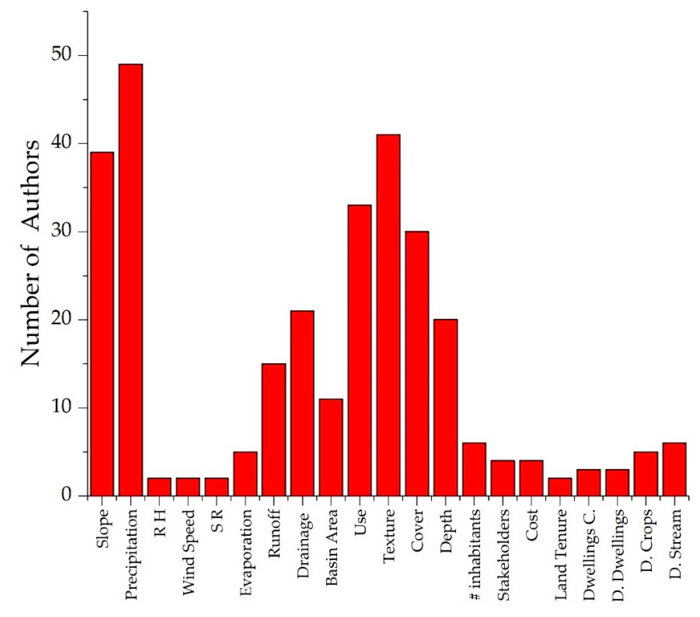
| Author | Climatological Characteristics | Physiographic Characteristics | Soil | Socioeconomics | Distance to | ||||||||||||||||
|---|---|---|---|---|---|---|---|---|---|---|---|---|---|---|---|---|---|---|---|---|---|
| Precipitation | Relative Humidity | Wind Speed and Direction | Solar Radiation | Evaporation | Drainage Network | Slope | Runoff | Basin Area | Use | Texture | Cover | Depth | No. Inhabitants | Interview to Stakeholders | Cost | Land Tenure | Dwelling Characteristics | Dwellings | Crops | Stream | |
| Gupta et al., 1997 [53] | X | X | X | X | X | X | X | ||||||||||||||
| Srivastava, 2001 [54] | X | X | X | ||||||||||||||||||
| Senay and Verdin, 2004 [55] | X | X | X | X | |||||||||||||||||
| de Winnaar, Jewitt, and Horan, 2007 [56] | X | X | X | X | X | X | X | ||||||||||||||
| Forzieri et al., 2008 [57] | X | X | X | X | X | X | X | X | |||||||||||||
| Roy et al., 2009 [58] | X | X | X | X | |||||||||||||||||
| Sturm, Zimmermann et al. 2009 [59] | X | X | X | ||||||||||||||||||
| Al-Daghastani, 2010 [60] | X | X | X | X | |||||||||||||||||
| Salih and Mehdi Al-Tarif, 2012 [61] | X | X | X | X | X | ||||||||||||||||
| Ziadat et al., 2012 [62] | X | X | X | X | X | X | X | X | |||||||||||||
| Jayasuriya et al., 2014 [63] | X | X | X | ||||||||||||||||||
| Jabr and El-Awar, 2004 [64] | X | X | X | X | X | ||||||||||||||||
| Mahmoud and Tang, 2015 [65] | X | X | X | X | X | ||||||||||||||||
| Adham et al., 2016 [66] | X | X | X | X | X | X | |||||||||||||||
| Mekonnenet et al., 2016 [25] | X | X | X | X | X | X | X | X | X | ||||||||||||
| Sayl et al., 2016 [67] | X | X | X | X | X | X | X | ||||||||||||||
| Mahmood and Hossain, 2017 [68] | X | X | X | X | |||||||||||||||||
| Terêncio et al., 2017 [69] | X | X | X | X | X | X | X | ||||||||||||||
| Terêncio et al., 2018 [70] | X | X | X | X | X | X | X | ||||||||||||||
| Author | Climatological Characteristics | Physiographic Characteristics | Soil | Socioeconomics | Distance to | ||||||||||||||||
|---|---|---|---|---|---|---|---|---|---|---|---|---|---|---|---|---|---|---|---|---|---|
| Precipitation | Relative Humidity | Wind Speed and Direction | Solar Radiation | Evaporation | Drainage Network | Slope | Runoff | Basin Area | Use | Texture | Cover | Depth | No. Inhabitants | Interview to Stakeholders | Cost | Land Tenure | Dwelling Characteristics | Dwellings | Crops | Stream | |
| Bhatnagar et al., 1996 [72] | X | X | |||||||||||||||||||
| Oweis et al., 1998 [73] | X | X | X | X | X | X | |||||||||||||||
| Schiettecatte et al., 2005 [74] | X | X | X | ||||||||||||||||||
| Ziadat et al., 2006 [75] | X | X | X | X | X | ||||||||||||||||
| Mbilinyi et al., 2007 [76] | X | X | X | X | X | X | X | ||||||||||||||
| Al Ali et al., 2008 [77] | X | X | |||||||||||||||||||
| Bakir and Xingnan, 2008 [78] | X | X | X | X | X | ||||||||||||||||
| Al-Seekh and Mohammad, 2009 [79] | X | X | X | X | X | ||||||||||||||||
| Bekele Awulachew et al., 2009 [80] | X | X | X | X | X | ||||||||||||||||
| Mechlia et al., 2009 [81] | X | X | X | X | X | X | X | X | X | ||||||||||||
| Previati et al., 2010 [82] | X | X | |||||||||||||||||||
| Al-Shamiri and Ziadat, 2012 [83] | X | X | X | X | |||||||||||||||||
| Krois and Schulte, 2014 [84] | X | X | X | X | X | X | |||||||||||||||
| Napoli et al., 2014 [34] | X | X | X | X | X | X | X | X | |||||||||||||
| Mahmoud and Alazba, 2015 [85] | X | X | X | X | X | X | |||||||||||||||
| Adham et al., 2016 [86] | X | X | X | ||||||||||||||||||
| Author | Climatological Characteristics | Physiographic Characteristics | Soil | Socioeconomics | Distance to | ||||||||||||||||
|---|---|---|---|---|---|---|---|---|---|---|---|---|---|---|---|---|---|---|---|---|---|
| Precipitation | Relative Humidity | Wind Speed and Direction | Solar Radiation | Evaporation | Drainage Network | Slope | Runoff | Basin Area | Use | Texture | Cover | Depth | No. Inhabitants | Interview to Stakeholders | Cost | Land Tenure | Dwelling Characteristics | Dwellings | Crops | Stream | |
| Durbude and Venkatesh, 2004 [89] | X | X | X | X | X | X | |||||||||||||||
| Bamne et al., 2014 [90] | X | X | X | X | X | ||||||||||||||||
| Sekar and Randhir, 2007 [91] | X | X | X | X | X | X | |||||||||||||||
| Ramakrishnan et al., 2008 [92] | X | X | X | X | X | X | |||||||||||||||
| Ramakrishnan et al., 2009 [93] | X | X | X | X | |||||||||||||||||
| Glendenning and Vervoort, 2010 [94] | X | X | X | X | X | X | |||||||||||||||
| Glendenning and Vervoort, 2011 [95] | X | X | X | X | X | X | |||||||||||||||
| Kadam et al. 2012 [96] | X | X | X | X | X | X | X | X | |||||||||||||
| Mahmoud, 2014 [97] | X | X | X | X | X | X | X | ||||||||||||||
| Author | Climatological Characteristics | Physiographic Characteristics | Soil | Socioeconomics | Distance to | ||||||||||||||||
|---|---|---|---|---|---|---|---|---|---|---|---|---|---|---|---|---|---|---|---|---|---|
| Precipitation | Relative Humidity | Wind Speed and Direction | Solar Radiation | Evaporation | Drainage Network | Slope | Runoff | Basin Area | Use | Texture | Cover | Depth | No. Inhabitants | Interview to Stakeholders | Cost | Land Tenure | Dwelling Characteristics | Dwellings | Crops | Stream | |
| Banai-Kashani, 1989 [99] | X | X | |||||||||||||||||||
| Oweis, 1999 [46] | X | X | X | X | X | X | X | X | |||||||||||||
| Prinz and Singh, 2000 [100] | X | X | X | X | X | X | X | X | |||||||||||||
| Mbilinyi et al., 2005 [101] | X | X | X | X | |||||||||||||||||
| Mati et al., 2007 [102] | X | X | X | X | X | X | |||||||||||||||
| Mwenge Kahinda et al., 2008 [87] | X | X | X | X | X | X | |||||||||||||||
| Kamel and Mohammed, 2010 [103] | X | X | |||||||||||||||||||
| Ghani et al., 2013 [104] | X | X | X | ||||||||||||||||||
| Jha et al., 2014 [105] | X | X | X | X | X | X | |||||||||||||||
| Grum et al., 2016 [71] | X | X | X | X | X | X | X | ||||||||||||||
| Singh et al., 2017 [106] | X | X | X | X | X | ||||||||||||||||
| Author | Climatological Characteristics | Physiographic Characteristics | Soil | Socioeconomics | Distance to | ||||||||||||||||
|---|---|---|---|---|---|---|---|---|---|---|---|---|---|---|---|---|---|---|---|---|---|
| Precipitation | Relative Humidity | Wind Speed and Direction | Solar Radiation | Evaporation | Drainage Network | Slope | Runoff | Basin Area | Use | Texture | Cover | Depth | No. Inhabitants | Interview to Stakeholders | Cost | Land Tenure | Dwelling Characteristics | Dwellings | Crops | Stream | |
| Hackwell et al., 1991 [108] | X | X | X | X | |||||||||||||||||
| Rochester et al., 1994 [109] | X | ||||||||||||||||||||
| Ventura et al., 2003 [110] | X | X | |||||||||||||||||||
| Ventura et al., 2005 [111] | X | ||||||||||||||||||||
| Patrick et al., 2007 [112] | X | X | X | ||||||||||||||||||
| Botha et al., 2015 [113] | X | X | X | X | X | ||||||||||||||||
© 2019 by the authors. Licensee MDPI, Basel, Switzerland. This article is an open access article distributed under the terms and conditions of the Creative Commons Attribution (CC BY) license (http://creativecommons.org/licenses/by/4.0/).
Share and Cite
Martínez-Acosta, L.; López-Lambraño, A.A.; López-Ramos, A. Design Criteria for Planning the Agricultural Rainwater Harvesting Systems: A Review. Appl. Sci. 2019, 9, 5298. https://doi.org/10.3390/app9245298
Martínez-Acosta L, López-Lambraño AA, López-Ramos A. Design Criteria for Planning the Agricultural Rainwater Harvesting Systems: A Review. Applied Sciences. 2019; 9(24):5298. https://doi.org/10.3390/app9245298
Chicago/Turabian StyleMartínez-Acosta, Luisa, Alvaro Alberto López-Lambraño, and Alvaro López-Ramos. 2019. "Design Criteria for Planning the Agricultural Rainwater Harvesting Systems: A Review" Applied Sciences 9, no. 24: 5298. https://doi.org/10.3390/app9245298
APA StyleMartínez-Acosta, L., López-Lambraño, A. A., & López-Ramos, A. (2019). Design Criteria for Planning the Agricultural Rainwater Harvesting Systems: A Review. Applied Sciences, 9(24), 5298. https://doi.org/10.3390/app9245298