Article

Estimating Non-Sustainable Soil Erosion Rates in the Tierra de Barros Vineyards (Extremadura, Spain) Using an ISUM Update

by
Jesús Rodrigo-Comino
1,2,*,
Jesús Barrena-González
3,
Manuel Pulido-Fernández
3 and
Artemi Cerdá
4
1
Physical Geography, Trier University, 54286 Trier, Germany
2
Instituto de Geomorfologia y Suelos, Department of Geography, University of Malaga, 29071 Malaga, Spain
3
GeoEnvironmental Research Group (GIGA), University of Extremadura, 10071 Cáceres, Spain
4
Soil Erosion and Degradation Research Group, Department of Geography, University of Valencia, 46010 Valencia, Spain
*
Author to whom correspondence should be addressed.
Appl. Sci. 2019, 9(16), 3317; https://doi.org/10.3390/app9163317
Submission received: 29 July 2019 / Revised: 6 August 2019 / Accepted: 9 August 2019 / Published: 13 August 2019

Abstract

:

Featured Application

Soil erosion estimations using an easy-to-apply and low-cost method.

Abstract

Monitoring soil erosion processes and measuring soil and water yields allow supplying key information to achieve land degradation neutrality challenges. Vineyards are one of the most affected agricultural territories by soil erosion due to human and natural factors. However, the spatial variability of soil erosion, the number of sampling points, and plot size necessary to estimate accurate soil erosion rates remains unclear. In this research, we determine how many inter-rows should be surveyed to estimate the soil mobilization rates in the viticulture area of Tierra de Barros (Extremadura, SW Spain) using the Improved Stock Unearthing Method (ISUM). This method uses the graft union of the vines as a passive biomarker of the soil surface level changes since the time of plantation and inter-row measures. ISUM was applied to three inter-row and four rows of vines (5904 sampling points) in order to determine how many surfaces and transects must be surveyed as all the previous surveys were done with only one inter-row. The results showed average values of soil depletion reaching −11.4, −11.8, and −11.5 cm for the inter-rows 1, 2, and 3, respectively. The current soil surface level descended 11.6 cm in 20 years. The inter-rows 1, 2, and 3 with a total area of 302.4 m2 each one (2016 points) recorded 71.4, 70.8, and 74.0 Mg ha−1 yr−1, respectively. With the maximum number of sampling points (5904), 71.2 Mg ha−1 yr−1 were obtained. The spatial variability of the soil erosion was shown to be very small, with no statistically significant differences among inter-rows. This could be due to the effect of the soil profile homogenization as a consequence of the intense tillage. This research shows the potential predictability of ISUM in order to give an overall overview of the soil erosion process for vineyards that follow the same soil management system. We conclude that measuring one inter-row is enough to get an overview of soil erosion processes in vineyards when the vines are under the same intense tillage management and topographical conditions. Moreover, we demonstrated the high erosion rates in a vineyard within the viticultural region of the Tierra de Barros, which could be representative for similar vineyards with similar topographical conditions, soil properties, and a possible non-sustainable soil management system.

1. Introduction

Accurate soil erosion measurements and modelling at different scales have received increasing attention from the scientific community throughout the last century [1,2,3]. This is due to the negative environmental impacts of soil erosion on natural ecosystems and man-made landscapes [4,5]. The need to find control measures according to the water and soil loss rates of each study case has drastically increased using a wide range of multiple methods and tools [6,7,8]. Soil erosion negatively threatens the land affecting vital ecosystem services such as soil fertility [9,10] and respiration [11], biological activity [12,13], or pollutant transport [14], among others. However, each land use shows a different response depending on specific key drivers such as climate, parent material, soil type, and management, vegetation cover, or topography [15,16,17]. There is a consensus that states vineyards as one of the most affected land uses by soil erosion [18,19,20].
The active scientific community researching soil erosion in agriculture lands such as vineyards found flaws in the methodologies applied. Some methods that quantify soil erosion rates show values that are not adequate as a consequence of possible overestimation [21,22,23]. Moreover, many of the methods were applied to investigate soil erosion processes in specific locations such as rainfall simulators [24], Gerlach troughs [25], or erosion pins [26], and the holistic view of the landscape is lost. In addition, some other methods are not able to show the spatial variability of the soil losses as the approach focuses on the discharge of a river watershed or basin connectivity [27,28]. Additionally, from a temporal point of view, there are many flaws in some soil erosion methods. Most of the research is focused on a thunderstorm such as the ones based on rainfall simulations experiments, or in a few months or years of measurements [29,30]. Then, long-term soil erosion rates are rare, although they are the ones that are able to inform of the impact of soil erosion and Earth sustainability. There is a need to improve methodologies applied to survey soil erosion rates both from a spatial and temporal point of view. One example can be the ISUM (Improved Stock Unearthing Method), which allows surveying long-term soil mobilization rates and providing information about the sediment spatial distribution [31]. However, when using ISUM, previous researchers sampled one inter-row of vines. In addition, there is a doubt about how this strategy affects the final result. It is accepted and demonstrated that soil erosion is different at different locations and slope positions such as what Rodrigo-Comino et al. [32] found. However, how different the erosion rate will be in the same hillslope position and soil type from one inter-row to the nearest one is still unclear. This will be a fundamental issue to evaluate the accuracy of the ISUM to standardize the method and to clarify how many sampling points, and where, should be taken. There is a debate about whether the position in a vineyard affects the soil detachment and runoff activation under rainfall simulation experiments [33], but there is no long-term research and this paper investigated this issue.
There are three areas that need to be improved in order to increase the scientific knowledge of soil erosion in vineyards: (i) the accuracy of the measures; (ii) the standardization of the protocols; and, (iii) an increase of the measurements reaching the most relevant viticultural areas of the world. Accurate measures in soil erosion investigations depend on different factors, such as the size of the plot [34,35], design of the plot [36], device used [37], factors [38,39], seasonal changes [40], or the number of repetitions or points to be measured [41]. They are well-known constraints of carrying out the same method in different regions because of economic costs, logistic issues, and agreement among research groups. This issue defaults the third unsolved question. If standard measures characterized by low costs and easy-to-apply procedures are designed, more vineyards could be studied. Therefore, to achieve these goals, this study estimated soil erosion rates in the viticultural area of Tierra de Barros using ISUM, which considers the graft union of the vines as a passive biomarker of the soil surface level changes and measures in the inter-row and rows. For this study case, for the first time, ISUM was applied to three inter-row and four rows in order to determine how many points and transects must be measured to achieve an accurate measurement of the soil losses.

2. Materials and Methods

2.1. Study Area

We selected a vineyard located in the viticultural region of the Tierra de Barros (Figure 1a; Extremadura, SW Spain), where there is a lack of information about soil erosion research. The vines are situated in a field 5 km from the municipality of Arroyo de San Serván (Badajoz), which belongs to the farm “La Agraria”. We consider this plot as representative because it follows the same pattern of the majority of the vineyards of the Tierra de Barros, which are mounted on a conventional trellis system supported by irrigation. The mean total annual precipitation reaches 425.2 mm and the mean annual temperature is 16.5 °C (Arroyo de San Serván meteorological station) (REDAREX, 38°51’29000’’ N/06°28′22000″ W). The studied vineyard registers a Mediterranean climate type characterized by cold months like January reaching mean temperatures of about 8.0 °C and warm months like July with 26.9 °C. November (55.9 mm) and July are (4.4 mm) the wettest and the driest months, respectively [42].
The plants are disposed along the rows in espaliers in order to enhance the photosynthesis and production of grapes, which is expected to get the first results after three years. The vines are growing on an American rootstock graft due to the potential issues related to the Phylloxera. The mean altitude ranges from 165 to 265 m a.s.l. (Figure 1b). The parent material is characterized by gravels and cobles, which come from fluvial processes during the Quaternary [43]. The three selected inter-rows are located close to a small fluvial channel following the hillslope direction (Figure 1c). In Figure 1d, a longitudinal profile for each transect and the height are depicted in order to show that the topographical changes are not so different among them. The vineyard is 20 years old, with the variety of Cayetana grape (autochthonous variety), and a planting frame of 2.8 × 1.5 m (Figure 1e). Each row contains approximately 140 plants (210 m in length). It is important to highlight that the whole plantation is managed by tillage, which is conducted three times per year. A John Deere tractor, model 5090 m, with four cylinders and a displacement of 4525 cm3 is used. The front and rear tires are 340/85 R24 and 420/85 R34, respectively, summarizing a total weight of 4900 kg. In Figure 1f, it can be noted the clear effect of the wheel tracks generating rills and ephemeral gullies. As a consequence, the soil can be classified as a calcic Luvisol [44], which is highly anthropized. The observed soil profile reaches a useful soil depth up to 140 cm. On the soil surface, there is moderate stoniness ranging from 5% to 15%, with a more abundant presence on the Ap horizon where it reaches close to 50% (Figure 1g,h).

2.2. Applying ISUM (Improved Stock Unearthing Method) in Vineyards

In Figure 2, a flowchart is shown in order to better explain how ISUM should be applied. The ISUM allows estimating soil mobilization changes, taking into account the union of a grafted plant and performing cross-sectional measurements in the inter-row areas [31] (Figure 2a). Previously, it was mandatory to confirm through observations in situ of new plantations, and with the farmers, that the graft union part did not vertically grow [45]. When the vine came from the nursery, it was covered by a plastic cylinder from 30 to 40 cm length and 10 cm diameter that helps to prevent against damages made by rabbits and herbicides, making it easy to find the grafted part. This method uses the graft union as a passive bio-marker of the current soil surface level at the time of measurement, obtaining the differences with the paleo-surface at the time of plantation [46,47] (Figure 2b,c). The grafts were placed at the surface (0 cm) and the vertical growth of the graft was negligible since it is the new vine that undergoes all evolution [48,49] as the farmers confirmed using informal interviews without a structured questionnaire during the field campaign (May 2018). This method can be considered as a low-cost and easy-to-apply tool because the required unique materials are a meter tape, notebooks, and pencils. Moreover, a couple of people can measure around 1000 points per day. In our field protocol, the same researcher had to find the graft of the strain, which indicates the initial soil surface level that registers the soil at the time of planting. The rope to measure the topography was tied at 0 cm above the graft. We lifted it as we found some buried craft (Figure 2d). After finding the graft union in each paired-vine, a meter tape was stretched between them to take measures each 10 cm (Figure 2e,f). In this investigation, a total of 28 measures were performed (two in each graft union and 26 in the inter-row area), obtaining a greater accuracy than in previous works where part of the surface between rows was not measured [41]. A total of 5904 points were measured using four rows and three inter-rows (Figure 2g).

2.3. Mapping Soil Surface Changes Because of Mobilization or Accumulation Processes Using ISUM

The ISUM allows obtaining a map of the current soil surface level along with the inter-row areas. When the measurements are tipped in an electronic format, the data are incorporated into ArcMap 10.5 (ESRI, Redlands, CA, USA) as a shapefile format. The points are digitalized using the tool “fishnet” taking as a reference, the beginning of each row, which was measured using a GPS. In order to obtain the most correct ISUM map, several interpolation methods were tested to get a current DEM (Digital Elevation Model): Ordinary Kriging (OK) with anisotropy, Multi-Quadratic (M-Q), Empirical Bayesian Kriging (EBK), Thin Plate Spline (TPS), IM-Q (Inverse Multi-Quadratic), Inverse Distance Weight (IDW), Completely Regularized Spline (CRS), and Spline with Tension (ST). For all the methods, the RMSE (root mean square error) and R2 (coefficient of determination) were calculated. Table 1 shows the values referring to the mean, the mean square error, and the square error of each interpolation method. The lowest error and highest coefficients were obtained for the OK, obtaining a resolution of 0.03 m per pixel size.

2.4. Statistical Analysis, Graphical Representation, and Estimations of Soil Mobilization Rates

Firstly, the results were depicted in box plots graphs in order to show the variation of the collected values. The 5th and 95th percentiles were included too. Secondly, the total average values, and the maximum and minimum ones, were also represented in linear graphs for each inter-row area measured.
Soil mobilization rates were estimated using Equation (1), proposed by Paroissien et al. [50], named erosion-deposition (ER) for each inter-row area and summarized as:
E R = Vol × BDs A × Yr
where the volume (Vol), the total area of the measured field (A), the years of the vines (Yr, 20 years), and the bulk density were used as input elements. The soil bulk density represents the average of measurements collected in a 100 cm3 cylinder [51] at seven different points along the row and inter-row area. The results obtained were 1.24, 1.20, and 1.29 g cm−3, for the left (inter-row 1), middle (inter-row 2), and right (inter-row 3) inter-rows, respectively.
Finally, the results obtained from each row and inter-row areas were compared using a Tukey-test. Prior to conducting each analysis, a normality test (Shapiro–Wilk) and an equal variance test were performed. We used the software SigmaPlot 12.0 (Systat, Chicago, IL, USA).

3. Results

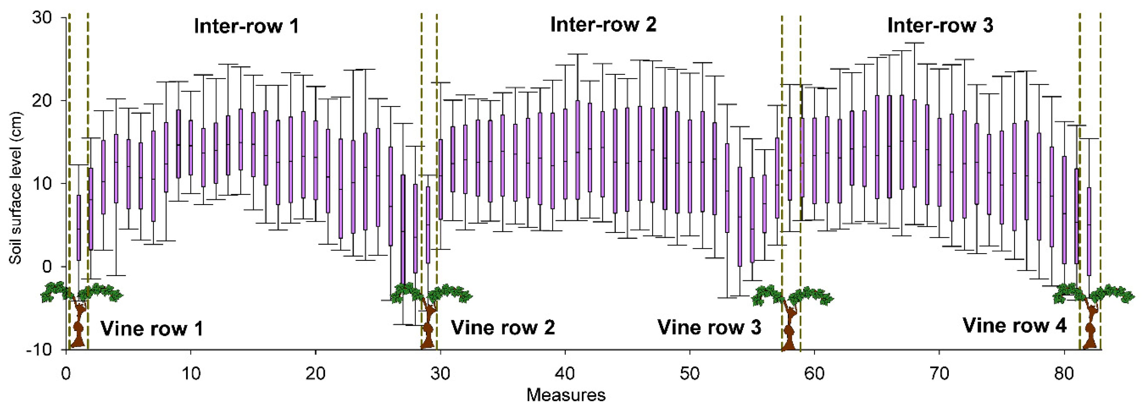
3.1. Soil Surface-Level Changes

In Figure 3 and Figure 4, the variations of the soil surface change with a cross-sectional view are depicted in box plots and linear graphs, respectively. The inter-row 1 registers average values of −11.4 ± 7.7 cm, reaching a maximum accumulation of 20 cm. The maximum depletion value was of 33.9 cm. For the inter-row 2, −11.8 ± 7.6 cm are the average soil surface level values, and 18 and −33.3 cm are the maximum accumulation and depletion values observed. In the inter-row 3, −11.5 ± 8 cm are the average values of soil surface level, recording a maximum accumulation of 12.4 cm and maximum depletion of −33.9 cm. If we consider the average values of the inter-rows 1 and 2, we obtain a soil surface level of −11.7 ± 7.6 cm. On the other hand, by averaging inter-rows 1, 2, and 3, the results show a current soil surface level of −11.6 ± 7.7 cm.
The statistical analysis demonstrates the differences in the mean values among the rows and inter-row measures. The results show that the differences are not great enough therefore, we can conclude there is not a statistically significant difference. Comparing inter-rows 1 and 2, 2 and 3, and 1 and 3, we obtained p = 0.147, p = 0.178, and p = 0.943, respectively.
In Figure 5, the ISUM map is generated in order to show the micro-topographical changes among the different inter-row areas and slope positions. In general, clear similarities among inter-row areas can be found. A clear soil mobilization process exists from the shoulder to the footslope. Along 108 m, we can note the highest depletion rates are found in the foot slope parts (red colors), reaching values close to −20 cm. It is interesting to highlight that in these parts, there are some areas with a yellow color that shows areas of accumulation in the middle of the row. The red color in both sides of these accumulation parts could clearly show the wheel track signals and surface flow paths. In the shoulder and backslope, we find the higher soil accumulation parts, although it is also remarkable that close to the vines, the soil surface level is lower than in the middle part. Values higher than 30 and 35 cm can be located where the hillslope starts to drastically descend (Figure 1d).

3.2. Estimation of Soil Mobilization Rates

Soil mobilization rates obtained after modelling the sampled points are shown in Table 2. The inter-rows 1, 2, and 3, each with a total area of 302.4 m2 (2016 points) record 71.4. 70.8, and 74.0 Mg ha−1 yr−1, respectively. Summarizing the data of the inter-rows 1 and 2 with a total sampling area of 604.8 m2 and using 3960 points, soil mobilization rates reach 70.7 Mg ha−1 yr−1. The final results obtained, using 5904 points (907.2 m2), are 71.2 Mg ha−1 yr−1.

4. Discussion

4.1. Erosion Rates in Tierras de Barros within a Mediterranean Perspective

Since the pioneering studies carried out in Chile and Germany using erosion plots and sediment collectors during the 70 s, the number of publications related to soil erosion in vineyards have drastically increased, reaching the peak since 2000 [52]. This is because of the interest in surveying the soil erosion rates and finding sustainable management practices [38,53]. However, there is much less innovation on new methods and techniques to measure the soil erosion rates, although there is a lack of surveys in many vineyards of the world. A wide spectrum of methods has been applied in vineyards but there is a lack of long-term soil erosion studies, which is also found in other crops [54,55]. The research at the Tierra de Barros study site confirms what the scientific community found in other vineyards: high soil mobilization rates (71.2 Mg ha−1 yr−1) which are not sustainable [56] if we compare these results to the other studies. In a meta-analysis, Cerdan et al. [19], considering 1350 experimental plots of different land uses areas, found that vineyards reached the highest erosion rates in Europe with 12.2 Mg ha−1 yr−1. Several investigations carried out in north Spanish vineyards affected by gullies registered soil mobilizations higher than 200 Mg ha−1 yr−1 during extreme rainfall events [23,57,58].
In Italy, we can observe some recent comparable investigations published in 2019 but with soil erosion rates lower than in the Tierra de Barros. For instance, Novara et al. [59] assessed the soil tillage erosion rate in a Sicilian vineyard using a 13C natural abundance tracer registering 9.5 ± 1.2 Mg ha−1 yr−1. On the other hand, using the USLE (Universal Soil Loss Equation) for the same area, Baimonte et al. [38] over the 10-year period of observation quantified up to 3 Mg ha−1 with a maximum of 13.2 Mg ha−1 in 2014. In addition, in Italy, Pijl et al. [60] applying the Revised Universal Soil Loss Equation (RUSLE) in 24 terraced vineyards located in north-eastern Italy calculated from 53.9 to 69.5 Mg ha−1 yr−1. In the Prosecco viticultural region, Pappalardo et al. [61] modelled a potential soil erosion that could reach 300,180 Mg yr−1, which represents 43.7 Mg ha−1 yr−1. The same authors estimated for a conventional land-management scenario 3.3 kg of soil for every bottle produced but it would be reduced to 1.1 kg per bottle if the total area were completely green land-managed. Therefore, it is clear that mandatory work in order to develop nature-based solutions should be selected by technicians and policymakers and applied by the farmers [5,62]. The comparison of the Tierra de Barros study site to other Mediterranean vineyards shows that the soil erosion rates are one order of magnitude higher and this is due to the intensification of the production with deep and recurrent tillage. This means that the soil is bare most of the year and then the soil erosion rates are very high and non-sustainable, such as Rodrigo-Comino [52] updated recently.

4.2. The Factors That Contribute to High Erosion Rates

The high soil erosion rates in Tierra de Barros are due to unfavorable factors. Firstly, the impact of the heavy machinery on the bare soils that contribute to overland flow (Figure 1f). The tillage is able to homogenize the soils and to increase the soil losses mainly in the sloping terrain [63]. These results are widespread in the Mediterranean vineyards [64,65]. The tillage clearly affects soil physical properties such as bulk density, that directly modifies the water retention capacity and saturated hydraulic conductivity [66]. Tillage is able to move the material downslope and generate vulnerable areas in the middle parts [67,68]. Another key factor in Tierra de Barros is the rock fragment content. In the upper parts, the amount of rocks is higher than in the foot parts (Figure 1g,h). Rocks allow infiltration of the water and retaining of the soil, defaulting soil transport, which will be even more efficient if they are in the soil profile [69,70].
The high erosion rates found in the footslope positions can be related to the slope angle. This assumption allows us to ask about the possibility that each specific inclination between paired-vines or sampling points could affect the activation of soil mobilization to different directions or even the runoff activation [71,72]. Several authors highlighted the importance of considering the soil roughness in the activation of soil erosion processes at the pedon scale [73,74] and connectivity processes at the hillslope one [75,76]; however, in vineyards, using in situ measurements such as ISUM is still poorly-studied. This is a new research topic to be developed in the near future such as the research carried out on soil roughness and inclination changes among sampled points, following the example of da Silva et al. [77] in persimmon plantations.
The scientific literature discusses plot sizes and the representability of the erosion and runoff plots [34,35,78,79]. Human- and nature-driven factors such as parent material [80], organic matter [81], vegetation cover [82], rock fragments [83] can greatly affect the spatial variability of hydrological and biological processes. Recent research conducted on the influence of weather types [84,85] also insisted that the elevated spatial and temporal variability of the soil erosion results among hillslopes and regions close to each other, considering factors such as the altitude [86], different soil managements, or geological discontinuities [87,88] as key factors of soil erosion.

4.3. One, Two, or Three Inter-Rows… How Many Inter-Rows Do We Need to Measure?

We measured the soil lowering during 25 years in 1, 2, and 3 inter-row areas. This information gave us the insight to understand the soil mobilization rates since the time of plantation using 2016, 3960, and 5904 sampling points. We covered a total area from 302.4 m2 in each row to 907.2 m2 in the whole study site. The total average estimations of soil mobilization did not show great differences among plot sizes. Values slightly higher than 70 Mg ha−1 yr−1 were recorded. The measurements with the second and third-row did not find different soil erosion rates. Then, we propose that only one inter-row should be measured and represents a homogeneous area.
Another key issue is to determine how representative the data recorded for an entire vineyard is. We affirm the potential predictability of ISUM in order to give an overall overview of the soil erosion process attending the obtained results for vineyards that follow the same soil management system. When ISUM is applied, an important decision must be made in order to determine the representative of the results: paying attention to the importance of measuring more separated areas in the same vineyard or, on the contrary, measuring continuous and parallel inter-row areas. This question should be answered in the future too.
Tillage is able to homogenize soil properties, and subsequently, soil erosion processes. Similar results were found among inter-rows in Eastern Spanish vineyards [89]. It would be interesting to test if there is a similar representativity of these results in ecological vineyards where no-tillage is applied.
ISUM has been seen as an easy-to-apply methodology as the measurements in the paired-graft union and performing three extra-measurements in the inter-row areas can supply key information for mapping soil erosion estimations in only one day. In this case, if we pass from measuring one inter-row area to testing three, increasing the number of sampling points and plot area, the time and efforts invested will be more elevated. Therefore, solving this issue will represent a new advance in the standardization of the method in order to be applied by other authors following the same procedure in the future.

5. Conclusions

In this research, we tested the differences measuring 1, 2, and 3 inter-row areas using 2016, 3960, and 5904 sampling points or plots of 302.4, 604.8, and 907.2 m2. The total average estimations of soil mobilization did not show great differences among plot sizes or the number of measured inter-rows. After sampling 5904 points, the results showed average values of soil depletion of −11.4, −11.8, and −11.5 cm for the inter-rows 1, 2, and 3, respectively. Considering the values of the whole plot, the current soil surface level descended 11.6 cm. The inter-rows 1, 2, and 3 had amounts of 71.4, 70.8, and 74.0 Mg ha−1 yr−1, respectively. Summarizing the final results obtained using 5904 points, 71.2 Mg ha−1 yr−1 was the total soil mobilized. We consider that the similar results obtained among inter-row areas could be as a consequence of the mobilization of the material following the same soil management system: the tillage. This research was able to demonstrate the potential predictability of ISUM in order to give an overall overview of the soil erosion process attending the obtained results for vineyards that follow the same soil management system such as tillage. We conclude that the soil erosion rates are extremely high (non-sustainable) and that ISUM could be applied only to one inter-row per landform.

Author Contributions

Conceptualization, J.R.-C., A.C., J.B.-G., M.P.-F.; methodology, J.R.-C., A.C. formal analysis, J.R.-C., investigation, J.R.-C., A.C., J.B.-G., M.P.-F.; writing—original draft preparation, J.R.-C., A.C., J.B.-G., M.P.-F.; writing—review and editing, J.R.-C., A.C., J.B.-G., M.P.-F.; visualization.

Funding

The study was financed by Junta de Extremadura and FEDER (Project IB16052). The landscapes of Extremadura inspired this research.

Acknowledgments

We wish to say thank you for the hospitality during the field campaign in the municipality of Arroyo de San Serván, especially to Isabel and Eduardo. Thanks to the cooperative farm “La Agraria” and their farmers (Juan Eugenio y Santiago) for providing all the information about the plot during the interviews. Additionally, we would like to say thank you for the great meals and hospitality during the nights in the Café-Bar “La Pantoja” whiles the authors were enjoying the Eurovision contest (2018) and the music of Alfred and Amaia. Finally, we would thank you the guest editor Dr Jomaa for the good job carried out during the edition process of this paper and his kindly invitation to take part of the special issue.

Conflicts of Interest

The authors declare no conflict of interest.

References

  1. Nearing, M.A.; Pruski, F.F.; O’Neal, M.R. Expected climate change impacts on soil erosion rates: A review. J. Soil Water Conserv. 2004, 59, 43–50. [Google Scholar]
  2. Ritchie, J.C.; McHenry, J.R. Application of Radioactive Fallout Cesium-137 for Measuring Soil Erosion and Sediment Accumulation Rates and Patterns: A Review. J. Environ. Qual. 1990, 19, 215. [Google Scholar] [CrossRef]
  3. De Vente, J.; Poesen, J.; Verstraeten, G.; Govers, G.; Vanmaercke, M.; Van Rompaey, A.; Arabkhedri, M.; Boix-Fayos, C. Predicting soil erosion and sediment yield at regional scales: Where do we stand? Earth Sci. Rev. 2013, 127, 16–29. [Google Scholar] [CrossRef]
  4. Panagos, P.; Ballabio, C.; Lugato, E.; Jones, A.; Borrelli, P.; Scarpa, S.; Orgiazzi, A.; Montanarella, L. Potential Sources of Anthropogenic Copper Inputs to European Agricultural Soils. Sustainability 2018, 10, 2380. [Google Scholar] [CrossRef]
  5. Keesstra, S.; Mol, G.; De Leeuw, J.; Okx, J.; Molenaar, C.; De Cleen, M.; Visser, S. Soil-Related Sustainable Development Goals: Four Concepts to Make Land Degradation Neutrality and Restoration Work. Land 2018, 7, 133. [Google Scholar] [CrossRef]
  6. Moayedi, H.; Nazir, R.; Foong, L.K.; Pradhan, B. A Review on Soil Erosion Control Studies. In Advances in Remote Sensing and Geo Informatics Applications; El-Askary, H.M., Lee, S., Heggy, E., Pradhan, B., Eds.; Springer International Publishing: Berlin/Heidelberg, Germany, 2019; pp. 211–213. [Google Scholar]
  7. Schmiedel, U.; Kruspe, M.; Kayser, L.; Oettlé, N. The Ecological and Financial Impact of Soil Erosion and its Control—A Case Study from the Semiarid Northern Cape Province, South Africa. Land Degrad. Dev. 2017, 28, 74–82. [Google Scholar] [CrossRef]
  8. Vacca, A.; Loddo, S.; Ollesch, G.; Puddu, R.; Serra, G.; Tomasi, D.; Aru, A. Measurement of runoff and soil erosion in three areas under different land use in Sardinia (Italy). Catena 2000, 40, 69–92. [Google Scholar] [CrossRef]
  9. Novara, A.; Pisciotta, A.; Minacapilli, M.; Maltese, A.; Capodici, F.; Cerdà, A.; Gristina, L. The impact of soil erosion on soil fertility and vine vigor. A multidisciplinary approach based on field, laboratory and remote sensing approaches. Sci. Total Environ. 2017, 622–623, 474–480. [Google Scholar] [CrossRef]
  10. Vaudour, E.; Leclercq, L.; Gilliot, J.; Chaignon, B. Retrospective 70 y-spatial analysis of repeated vine mortality patterns using ancient aerial time series, Pléiades images and multi-source spatial and field data. Int. J. Appl. Earth Obs. Geoinf. 2017, 58, 234–248. [Google Scholar] [CrossRef]
  11. Lal, R. Accelerated Soil erosion as a source of atmospheric CO2. Soil Tillage Res. 2019, 188, 35–40. [Google Scholar] [CrossRef]
  12. Vrsic, S.; Ivancic, A.; Pulko, B.; Valdhuber, J. Effect of soil management systems on erosion and nutrition loss in vineyards on steep slopes. J. Environ. Boil. 2011, 32, 289–294. [Google Scholar]
  13. Capó-Bauçà, S.; Marqués, A.; Llopis-Vidal, N.; Bota, J.; Baraza, E. Long-term establishment of natural green cover provides agroecosystem services by improving soil quality in a Mediterranean vineyard. Ecol. Eng. 2019, 127, 285–291. [Google Scholar] [CrossRef]
  14. Rickson, R. Can control of soil erosion mitigate water pollution by sediments? Sci. Total Environ. 2014, 468, 1187–1197. [Google Scholar] [CrossRef]
  15. Van Leeuwen, C.C.; Cammeraat, E.L.; De Vente, J.; Boix-Fayos, C. The evolution of soil conservation policies targeting land abandonment and soil erosion in Spain: A review. Land Use Policy 2019, 83, 174–186. [Google Scholar] [CrossRef]
  16. García-Ruiz, J.M. The effects of land uses on soil erosion in Spain: A review. Catena 2010, 81, 1–11. [Google Scholar] [CrossRef]
  17. Zaimes, G.N.; Emmanouloudis, D.; Iakovoglou, V. Estimating soil erosion in Natura 2000 areas located on three semi-arid Mediterranean Islands. J. Environ. Boil. 2012, 33, 277–282. [Google Scholar]
  18. García-Ruiz, J.M.; Beguería, S.; Nadal-Romero, E.; González-Hidalgo, J.C.; Lana-Renault, N.; Sanjuan, Y. A meta-analysis of soil erosion rates across the world. Geomorphology 2015, 239, 160–173. [Google Scholar] [CrossRef] [Green Version]
  19. Panagos, P.; Meusburger, K.; Ballabio, C.; Borrelli, P.; Alewell, C. Soil erodibility in Europe: A high-resolution dataset based on LUCAS. Sci. Total Environ. 2014, 479, 189–200. [Google Scholar] [CrossRef] [PubMed]
  20. Cerdan, O.; Govers, G.; Le Bissonnais, Y.; Van Oost, K.; Poesen, J.; Saby, N.; Gobin, A.; Vacca, A.; Quinton, J.; Auerswald, K.; et al. Rates and spatial variations of soil erosion in Europe: A study based on erosion plot data. Geomorphology 2010, 122, 167–177. [Google Scholar] [CrossRef]
  21. Napoli, M.; Cecchi, S.; Orlandini, S.; Mugnai, G.; Zanchi, C.A. Simulation of field-measured soil loss in Mediterranean hilly areas (Chianti, Italy) with RUSLE. Catena 2016, 145, 246–256. [Google Scholar] [CrossRef]
  22. Hacisalihoglu, S. Determination of soil erosion in a steep hill slope with different land-use types: A case study in Mertesdorf (Ruwertal/Germany). J. Environ. Boil. 2007, 28, 433–438. [Google Scholar]
  23. Ramos, M.C.; Martínez-Casasnovas, J.A.; García-Hernández, D.; Martínez-Casasnovas, J.A.; García-Hernández, D. Effects of land-use changes in vegetation cover and sidewall erosion in a gully head of the Penedès region (northeast Spain). Earth Surf. Process. Landf. 2009, 34, 1927–1937. [Google Scholar]
  24. Arnáez, J.; Ruiz-Flaño, P.; Lasanta, T.; Ortigosa, L.; Llorente, J.A.; Pascual, N.; Lana-Renault, N. Efectos de las rodadas de tractores en la escorrentía y erosión de suelos en laderas cultivadas con viñedos. Cuad. Investig. Geogr. 2012, 38, 115. [Google Scholar] [CrossRef]
  25. Rodrigo Comino, J.; Senciales, J.M.; Ramos, M.C.; Martínez-Casasnovas, J.A.; Lasanta, T.; Brevik, E.C.; Ries, J.B.; Ruiz Sinoga, J.D. Understanding soil erosion processes in Mediterranean sloping vineyards (Montes de Málaga, Spain). Geoderma 2017, 296, 47–59. [Google Scholar] [CrossRef]
  26. Novara, A.; Gristina, L.; Guaitoli, F.; Santoro, A.; Cerdà, A. Managing soil nitrate with cover crops and buffer strips in Sicilian vineyards. Solid Earth Discuss. 2013, 5, 257–279. [Google Scholar] [CrossRef]
  27. Ben Slimane, A.; Raclot, D.; Rebai, H.; Le Bissonnais, Y.; Planchon, O.; Bouksila, F. Combining field monitoring and aerial imagery to evaluate the role of gully erosion in a Mediterranean catchment (Tunisia). Catena 2018, 170, 73–83. [Google Scholar] [CrossRef]
  28. Anache, J.A.; Wendland, E.C.; Oliveira, P.T.; Flanagan, D.C.; Nearing, M.A.; Oliveira, P.T. Runoff and soil erosion plot-scale studies under natural rainfall: A meta-analysis of the Brazilian experience. Catena 2017, 152, 29–39. [Google Scholar] [CrossRef]
  29. Brandolini, P.; Cevasco, A.; Capolongo, D.; Pepe, G.; Lovergine, F.; Del Monte, M. Response of terraced slopes to a very intense rainfall event and relationships with land abandonment: A case study from Cinque Terre (Italy). Land Degrad. Dev. 2016. [Google Scholar] [CrossRef]
  30. Quiquerez, A.; Brenot, J.; Garcia, J.-P.; Petit, C. Soil degradation caused by a high-intensity rainfall event: Implications for medium-term soil sustainability in Burgundian vineyards. Catena 2008, 73, 89–97. [Google Scholar] [CrossRef]
  31. Rodrigo-Comino, J.; Cerdà, A. Improving stock unearthing method to measure soil erosion rates in vineyards. Ecol. Indic. 2018, 85, 509–517. [Google Scholar] [CrossRef] [Green Version]
  32. Rodrigo-Comino, J.; Keesstra, S.D.; Cerdà, A. Connectivity assessment in Mediterranean vineyards using improved stock unearthing method, LiDAR and soil erosion field surveys. Earth Surf. Process. Landf. 2018, 43, 2193–2206. [Google Scholar] [CrossRef]
  33. Rodrigo-Comino, J.; Keesstra, S.; Cerda, A. Soil Erosion as an Environmental Concern in Vineyards. The Case Study of Celler del Roure, Eastern Spain, by Means of Rainfall Simulation Experiments. Beverages 2018, 4, 31. [Google Scholar] [CrossRef]
  34. Chaplot, V.; Le Bissonnais, Y. Field measurements of interrill erosion under different slopes and plot sizes. Earth Surf. Process. Landf. 2000, 25, 145–153. [Google Scholar] [CrossRef]
  35. Sadeghi, S.; Seghaleh, M.B.; Rangavar, A.; Sadeghi, S.H. Plot sizes dependency of runoff and sediment yield estimates from a small watershed. Catena 2013, 102, 55–61. [Google Scholar] [CrossRef]
  36. Camera, C.; Djuma, H.; Bruggeman, A.; Zoumides, C.; Eliades, M.; Charalambous, K.; Abate, D.; Faka, M. Quantifying the effectiveness of mountain terraces on soil erosion protection with sediment traps and dry-stone wall laser scans. Catena 2018, 171, 251–264. [Google Scholar] [CrossRef]
  37. Iserloh, T.; Ries, J.; Arnáez, J.; Boix-Fayos, C.; Butzen, V.; Cerdà, A.; Echeverría, M.; Fernández-Gálvez, J.; Fister, W.; Geisler, C.; et al. European small portable rainfall simulators: A comparison of rainfall characteristics. Catena 2013, 110, 100–112. [Google Scholar] [CrossRef] [Green Version]
  38. Baiamonte, G.; Minacapilli, M.; Novara, A.; Gristina, L. Time Scale Effects and Interactions of Rainfall Erosivity and Cover Management Factors on Vineyard Soil Loss Erosion in the Semi-Arid Area of Southern Sicily. Water 2019, 11, 978. [Google Scholar] [CrossRef]
  39. Chevigny, E.; Quiquerez, A.; Petit, C.; Curmi, P. Lithology, landscape structure and management practice changes: Key factors patterning vineyard soil erosion at metre-scale spatial resolution. Catena 2014, 121, 354–364. [Google Scholar] [CrossRef]
  40. Pijl, A.; Tosoni, M.; Roder, G.; Sofia, G.; Tarolli, P. Pijl Design of Terrace Drainage Networks Using UAV-Based High-Resolution Topographic Data. Water 2019, 11, 814. [Google Scholar] [CrossRef]
  41. Rodrigo-Comino, J.; Keshavarzi, A.; Zeraatpisheh, M.; Gyasi-Agyei, Y.; Cerdà, A. Determining the best ISUM (Improved stock unearthing Method) sampling point number to model long-term soil transport and micro-topographical changes in vineyards. Comput. Electron. Agric. 2019, 159, 147–156. [Google Scholar] [CrossRef]
  42. Moral, F.J.; Rebollo, F.J.; Paniagua, L.L.; García-Martín, A. A GIS-based multivariate clustering for characterization and ecoregion mapping from a viticultural perspective. Span. J. Agric. Res. 2016, 14, 0206. [Google Scholar] [CrossRef]
  43. Moral, F.J.; Rebollo, F.J.; Paniagua, L.L.; García, A.; de Salazar, E.M. Application of climatic indices to analyse viticultural suitability in Extremadura, south-western Spain. Theor. Appl. Climatol. 2016, 123, 277–289. [Google Scholar] [CrossRef]
  44. IUSS Working Group. WRB World Reference Base for Soil Resources 2014; World Soil Resources Report; FAO: Rome, Italy, 2014. [Google Scholar]
  45. Brenot, J.; Quiquerez, A.; Petit, C.; Garcia, J.-P.; Davy, P. Soil erosion rates in Burgundian vineyards. Boll. Soc. Geol. Ital. 2006, 6, 169–173. [Google Scholar]
  46. Brenot, J.; Quiquerez, A.; Petit, C.; Garcia, J.-P. Erosion rates and sediment budgets in vineyards at 1-m resolution based on stock unearthing (Burgundy, France). Geomorphology 2008, 100, 345–355. [Google Scholar] [CrossRef]
  47. Casalí, J.; Gimenez, R.; De Santisteban, L.; Álvarez-Mozos, J.; Mena, J.; Lersundi, J.D.V.D. Determination of long-term erosion rates in vineyards of Navarre (Spain) using botanical benchmarks. Catena 2009, 78, 12–19. [Google Scholar] [CrossRef]
  48. LaMarche, V.C., Jr. Rates of Slope Degradation as Determined from Botanical Evidence, White Mountains, California; USGS: Leston, VA, USA, 1968. [Google Scholar]
  49. Quiquerez, A.; Chevigny, E.; Allemand, P.; Curmi, P.; Petit, C.; Grandjean, P. Assessing the impact of soil surface characteristics on vineyard erosion from very high spatial resolution aerial images (Côte de Beaune, Burgundy, France). Catena 2014, 116, 163–172. [Google Scholar] [CrossRef]
  50. Paroissien, J.-B.; Lagacherie, P.; Le Bissonnais, Y. A regional-scale study of multi-decennial erosion of vineyard fields using vine-stock unearthing–burying measurements. Catena 2010, 82, 159–168. [Google Scholar] [CrossRef]
  51. Al-Shammary, A.A.G.; Kouzani, A.Z.; Kaynak, A.; Khoo, S.Y.; Norton, M.; Gates, W. Soil Bulk Density Estimation Methods: A Review. Pedosphere 2018, 28, 581–596. [Google Scholar] [CrossRef]
  52. Rodrigo-Comino, J. Five decades of soil erosion research in “terroir”. The State-of-the-Art. Earth Sci. Rev. 2018, 179, 436–447. [Google Scholar] [CrossRef]
  53. Ayoubi, S.; Mokhtari, J.; Mosaddeghi, M.R.; Zeraatpisheh, M. Erodibility of calcareous soils as influenced by land use and intrinsic soil properties in a semiarid region of central Iran. Environ. Monit. Assess. 2018, 190, 192. [Google Scholar] [CrossRef]
  54. Taguas, E.; Guzmán, E.; Guzmán, G.; Vanwalleghem, T.; Gomez, J. Characteristics and importance of rill and gully erosion: A case study in a small catchment of a marginal olive grove. Cuad. Investig. Geogr. 2015, 41, 107. [Google Scholar] [CrossRef]
  55. Atucha, A.; Merwin, I.A.; Brown, M.G.; Gardiazabal, F.; Mena, F.; Adriazola, C.; Lehmann, J. Soil erosion, runoff and nutrient losses in an avocado (Persea americana Mill) hillside orchard under different groundcover management systems. Plant Soil 2013, 368, 393–406. [Google Scholar] [CrossRef]
  56. Verheijen, F.; Jones, R.; Rickson, R.; Smith, C. Tolerable versus actual soil erosion rates in Europe. Earth Sci. Rev. 2009, 94, 23–38. [Google Scholar] [CrossRef] [Green Version]
  57. Martinez-Casasnovas, J.A.; Antón-Fernández, C.; Ramos, M.C. Sediment production in large gullies of the Mediterranean area (NE Spain) from high-resolution digital elevation models and geographical information systems analysis. Earth Surf. Process. Landf. 2003, 28, 443–456. [Google Scholar] [CrossRef]
  58. Ramos, M.C. Soil water content and yield variability in vineyards of Mediterranean northeastern Spain affected by mechanization and climate variability. Hydrol. Process. 2006, 20, 2271–2283. [Google Scholar] [CrossRef]
  59. Novara, A.; Stallone, G.; Cerdà, A.; Gristina, L. The Effect of Shallow Tillage on Soil Erosion in a Semi-Arid Vineyard. Agronomy 2019, 9, 257. [Google Scholar] [CrossRef]
  60. Pijl, A.; Barneveld, P.; Mauri, L.; Borsato, E.; Grigolato, S.; Tarolli, P. Impact of mechanisation on soil loss in terraced vineyard landscapes. Cuad. Investig. Geogr. 2019, 45, 287. [Google Scholar] [CrossRef]
  61. Pappalardo, S.E.; Gislimberti, L.; Ferrarese, F.; De Marchi, M.; Mozzi, P. Estimation of potential soil erosion in the Prosecco DOCG area (NE Italy), toward a soil footprint of bottled sparkling wine production in different land-management scenarios. PLoS ONE 2019, 14, e0210922. [Google Scholar] [CrossRef]
  62. Maes, J.; Jacobs, S. Nature-Based Solutions for Europe’s Sustainable Development. Conserv. Lett. 2017, 10, 121–124. [Google Scholar] [CrossRef]
  63. Arnáez, J.; Lasanta, T.; Ruiz-Flaño, P.; Ortigosa, L.; Ruiz, P. Factors affecting runoff and erosion under simulated rainfall in Mediterranean vineyards. Soil Tillage Res. 2007, 93, 324–334. [Google Scholar] [CrossRef]
  64. Biddoccu, M.; Ferraris, S.; Opsi, F.; Cavallo, E. Long-term monitoring of soil management effects on runoff and soil erosion in sloping vineyards in Alto Monferrato (North–West Italy). Soil Tillage Res. 2016, 155, 176–189. [Google Scholar] [CrossRef]
  65. Ferrero, A.; Usowicz, B.; Lipiec, J. Effects of tractor traffic on spatial variability of soil strength and water content in grass covered and cultivated sloping vineyard. Soil Tillage Res. 2005, 84, 127–138. [Google Scholar] [CrossRef]
  66. Kisic, I.; Bogunovic, I.; Zgorelec, Z.; Bilandzija, D. Effects of soil erosion by water under different tillage treatments on distribution of soil chemical parameters. Soil Water Res. 2018, 13, 36–43. [Google Scholar] [CrossRef] [Green Version]
  67. Cerdá, A. Soil erosion after land abandonment in a semiarid environment of southeastern Spain. Arid. Soil Res. Rehabil. 1997, 11, 163–176. [Google Scholar] [CrossRef]
  68. Cerdà, A. The effect of patchy distribution of Stipa tenacissim aL. on runoff and erosion. J. Arid Environ. 1997, 36, 37–51. [Google Scholar] [CrossRef]
  69. Jomaa, S.; Barry, D.; Brovelli, A.; Heng, B.; Sander, G.; Parlange, J.-Y.; Rose, C.; Barry, D. Rain splash soil erosion estimation in the presence of rock fragments. Catena 2012, 92, 38–48. [Google Scholar] [CrossRef] [Green Version]
  70. Jomaa, S.; Barry, D.; Brovelli, A.; Sander, G.; Parlange, J.-Y.; Heng, B.; Meerveld, H.T.-V.; Barry, D. Effect of raindrop splash and transversal width on soil erosion: Laboratory flume experiments and analysis with the Hairsine–Rose model. J. Hydrol. 2010, 395, 117–132. [Google Scholar] [CrossRef]
  71. Nadal-Romero, E.; Petrlic, K.; Verachtert, E.; Bochet, E.; Poesen, J.; Nadal-Romero, E. Effects of slope angle and aspect on plant cover and species richness in a humid Mediterranean badland. Earth Surf. Process. Landf. 2014, 39, 1705–1716. [Google Scholar] [CrossRef]
  72. Fox, D.; Bryan, R.; Price, A. The influence of slope angle on final infiltration rate for interrill conditions. Geoderma 1997, 80, 181–194. [Google Scholar] [CrossRef]
  73. Nearing, M.A.; Polyakov, V.O.; Nichols, M.H.; Hernandez, M.; Li, L.; Zhao, Y.; Armendariz, G. Slope–velocity equilibrium and evolution of surface roughness on a stony hillslope. Hydrol. Earth Syst. Sci. 2017, 21, 3221–3229. [Google Scholar] [CrossRef]
  74. Römkens, M.; Helming, K.; Prasad, S. Soil erosion under different rainfall intensities, surface roughness, and soil water regimes. Catena 2002, 46, 103–123. [Google Scholar] [CrossRef]
  75. López-Vicente, M.; Álvarez, S.; López-Vicente, M. Influence of DEM resolution on modelling hydrological connectivity in a complex agricultural catchment with woody crops. Earth Surf. Process. Landf. 2018, 43, 1403–1415. [Google Scholar] [CrossRef]
  76. Ben-Salem, N.; Álvarez, S.; López-Vicente, M. Soil and Water Conservation in Rainfed Vineyards with Common Sainfoin and Spontaneous Vegetation under Different Ground Conditions. Water 2018, 10, 1058. [Google Scholar] [CrossRef]
  77. Da Silva, A.M.; Moradi, E.; Rodrigo-Comino, J.; Cerdà, A. Spatial variability of soil roughness in persimmon plantations: A new combined ISUM (improved stock unearthing method) approach. Ecol. Indic. 2019, 106, 105528. [Google Scholar] [CrossRef]
  78. Bagarello, V.; Ferro, V.; Keesstra, S.; Comino, J.R.; Pulido, M.; Cerdà, A. Testing simple scaling in soil erosion processes at plot scale. Catena 2018, 167, 171–180. [Google Scholar] [CrossRef]
  79. Boix-Fayos, C.; Martínez-Mena, M.; Arnau-Rosalén, E.; Calvo-Cases, A.; Castillo, V.; Albaladejo, J. Measuring soil erosion by field plots: Understanding the sources of variation. Earth Sci. Rev. 2006, 78, 267–285. [Google Scholar] [CrossRef]
  80. Mohammadkhan, S.; Ahmadi, H.; Jafari, M. Relationship between soil erosion, slope, parent material, and distance to road (Case study: Latian Watershed, Iran). Arab. J. Geosci. 2011, 4, 331–338. [Google Scholar] [CrossRef]
  81. Garcia, L.; Celette, F.; Gary, C.; Ripoche, A.; Valdés-Gómez, H.; Metay, A. Management of service crops for the provision of ecosystem services in vineyards: A review. Agric. Ecosyst. Environ. 2018, 251, 158–170. [Google Scholar] [CrossRef] [Green Version]
  82. Lieskovský, J.; Kenderessy, P. Modelling the effect of vegetation cover and different tillage practices on soil erosion in vineyards: A case study in Vráble (Slovakia) using WATEM/SEDEM. Land Degrad. Dev. 2014, 25, 288–296. [Google Scholar] [CrossRef]
  83. Certini, G.; Campbell, C.D.; Edwards, A.C. Rock fragments in soil support a different microbial community from the fine earth. Soil Boil. Biochem. 2004, 36, 1119–1128. [Google Scholar] [CrossRef]
  84. Peña-Angulo, D.; Nadal-Romero, E.; González-Hidalgo, J.; Albaladejo, J.; Andreu, V.; Bagarello, V.; Barhi, H.; Batalla, R.J.; Bernal, S.; Bienes, R.; et al. Spatial variability of the relationships of runoff and sediment yield with weather types throughout the Mediterranean basin. J. Hydrol. 2019, 571, 390–405. [Google Scholar] [CrossRef] [Green Version]
  85. Rodrigo-Comino, J.; Senciales, J.M.; Sillero-Medina, J.A.; Gyasi-Agyei, Y.; Ruiz-Sinoga, J.D.; Ries, J.B. Analysis of Weather-Type-Induced Soil Erosion in Cultivated and Poorly Managed Abandoned Sloping Vineyards in the Axarquía Region (Málaga, Spain). Air Soil Water Res. 2019, 12, 1178622119839403. [Google Scholar] [CrossRef]
  86. Sadeghi, S.H.; Nouri, H.; Faramarzi, M. Assessing the Spatial Distribution of Rainfall and the Effect of Altitude in Iran (Hamadan Province). Air Soil Water Res. 2017, 10, 1178622116686066. [Google Scholar] [CrossRef]
  87. Gholami, H.; TakhtiNajad, E.J.; Collins, A.L.; Fathabadi, A. Monte Carlo fingerprinting of the terrestrial sources of different particle size fractions of coastal sediment deposits using geochemical tracers: Some lessons for the user community. Environ. Sci. Pollut. Res. 2019, 26, 13560–13579. [Google Scholar] [CrossRef]
  88. Habibi, S.; Gholami, H.; Fathabadi, A.; Jansen, J.D. Fingerprinting sources of reservoir sediment via two modelling approaches. Sci. Total. Environ. 2019, 663, 78–96. [Google Scholar] [CrossRef]
  89. Rodrigo-Comino, J.; Davis, J.; Keesstra, S.D.; Cerdà, A. Updated Measurements in Vineyards Improves Accuracy of Soil Erosion Rates. Agron. J. 2018, 110, 1–7. [Google Scholar] [CrossRef]
Figure 1. Location of the study area (a), topographical changes (be) and soils (fh).
Applsci 09 03317 g001
Figure 2. Flow chart including the Improved Stock Unearthing Method (ISUM) procedure. (a): sampling point strategy for each inter-row transect; (b): graft union; (c): wheel tractor pass; (df): applying ISUM; (g): changing from different sampling point scales.
Applsci 09 03317 g002
Figure 3. Box plots using the total measured points (n = 5904). The black line in each box plot represents the median value. The 5th and 95th percentiles are also included.
Applsci 09 03317 g003
Figure 4. Average values, maximum accumulation, and depletion in each inter-row area.
Applsci 09 03317 g004
Figure 5. ISUM map showing the current soil surface level.
Applsci 09 03317 g005
Table 1. Interpolation methods used.
MethodMeanRMSER2
OK Anisotropy0.0242.9010.858
M-Q0.0212.9780.851
IDW0.0282.9850.850
EBK0.0343.0110.847
ST0.0273.0740.844
TPS0.0073.1280.840
IM-Q0.0323.5070.806
CRS0.0303.5530.801
Method; OK: Ordinary Kriging; M-Q: Multi-Quadric; EBK: Empirical Bayesian Kriging; TPS: Thin Plate Spline; IM-Q: Inverse Multi-Quadric; IDW: Inverse Distance Weighting; CRS: Completely Regularized Spline; ST: Spline with Tension; RMSE: Root mean square error.
Table 2. Soil mobilization rates obtained using ISUM for one, two, and three plots.
VariablesInter-Row 1Inter-Row 2Inter-Row 31 + 21 + 2 + 3
Area m2 (long × width)302.4 (2.8 × 10⁸ m)604.8 (5.6 × 10⁸ m)907.2 (8.4 × 10⁸ m)
Number of points201639605904
m3 ha−134.835.734.770.1104.2
Mg ha−143.242.844.885.5129.2
Mg ha−1 yr−171.470.874.070.771.2

