Review

Emerging Technologies for Soil Evaluation Using Spectrometry Sensing, Internet of Things and Machine Learning


by
Florin Nenciu
1,
Mihai Gabriel Matache
1,*,
Iuliana Gageanu
1,
Ioan Catalin Persu
1,
Florin Bogdan Marin
2 and
Iulian Florin Voicea
1
1
National Institute of Research—Development for Machines and Installations Designed for Agriculture and Food Industry—INMA Bucharest, 013811 Bucharest, Romania
2
Interdisciplinary Research Centre in the Field of Eco-Nano Technology and Advance Materials CC-ITI, Faculty of Engineering, “Dunarea de Jos” University of Galati, 47 Domneasca Street, 800008 Galati, Romania
*
Author to whom correspondence should be addressed.
Appl. Sci. 2026, 16(9), 4559; https://doi.org/10.3390/app16094559
Submission received: 18 April 2026 / Revised: 30 April 2026 / Accepted: 3 May 2026 / Published: 6 May 2026

Abstract

The transition from conventional laboratory-based soil analysis to real-time, data-driven evaluation has become essential for advancing precision agriculture and ensuring sustainable resource management. This review provides a comprehensive and structured synthesis of emerging technologies for soil evaluation, focusing on the integration of spectrometric sensing, Internet of Things (IoT) systems, and machine learning approaches. A systematic analysis of peer-reviewed studies published between 2012 and 2026 was conducted to assess the performance of these technologies in terms of accuracy, robustness, and scalability under variable environmental conditions. Spectrometry techniques, including visible–near-infrared and mid-infrared sensing, enable rapid and non-destructive estimation of soil chemical properties, while IoT-based sensor networks facilitate continuous in situ monitoring of key parameters such as moisture, pH, and nutrient content. Machine learning models further enhance soil assessment by enabling predictive analytics, data fusion, and high-resolution mapping. Despite their significant potential, challenges related to data quality, model transferability, sensor calibration, and implementation costs remain critical barriers to large-scale adoption. The review highlights the need for standardized evaluation frameworks, improved multimodal data integration, and increased focus on model interpretability and real-world applicability. Overall, the synergistic use of these technologies supports more efficient input management, reduces environmental impact, and contributes to the development of resilient and sustainable agricultural systems.

1. Introduction

1.1. Context and Motivation: The Shift from Traditional Soil Analysis to Real-Time Soil Evaluation and Mapping

Emerging digital soil assessment tools play a pivotal role in modern agriculture by enabling accurate, timely, and spatially explicit evaluation of soil conditions. Technologies such as spectrometry, IoT-based sensors, remote sensing, and data-driven analytics facilitate continuous in situ monitoring of soil nutrients and physical properties. In contrast to conventional laboratory-based methods, these approaches support real-time decision-making while effectively capturing spatial variability at the scale required for precision agriculture. By integrating soil data with advanced machine learning models, farmers and agronomists can better anticipate nutrient deficiencies, optimize irrigation strategies, and improve overall input efficiency. These technologies contribute to improved resource use efficiency by minimizing excessive fertilizer application and reducing unnecessary water consumption. In the context of increasing climate variability, digital soil assessment tools enhance system resilience by enabling adaptive, site-specific management strategies. Their capacity to integrate soil status with crop performance data strengthens evidence-based agronomic decision-making. Furthermore, digital soil monitoring supports environmental sustainability by mitigating nutrient losses and limiting soil degradation processes. As data infrastructures continue to evolve, these technologies are progressively forming the foundation of intelligent decision support systems in agriculture. Consequently, emerging digital soil assessment approaches are becoming indispensable for achieving sustainable and productivity-oriented farming systems.
The need for efficient and precise agricultural practices is increasingly urgent due to the projected rise in global food demand driven by population growth. Soil properties, including nutrient content and physical characteristics such as texture, structure, and moisture retention, play a crucial role in land management strategies aimed at increasing crop yields. However, conventional soil evaluation methods, although highly accurate, are time-consuming and often lack the spatial resolution required to support precision agriculture [1,2].
Laboratory-based techniques, such as Kjeldahl nitrogen determination or Olsen phosphorus extraction, typically require between 24 and 72 h per sample when accounting for sampling, transport, preparation, and analysis. In contrast, modern spectrometric methods can provide results within seconds to minutes, enabling near real-time decision-making. From a spatial perspective, conventional soil sampling strategies are generally limited to low-density grids, commonly in the range of 1–5 samples per hectare, which restricts their ability to capture fine-scale spatial variability in heterogeneous fields. This often leads to interpolation errors and generalized management practices. By comparison, proximal and remote sensing approaches enable high-density or continuous data acquisition at sub-meter resolution. In terms of analytical performance, traditional laboratory methods remain the reference standard, often achieving coefficients of determination (R2) exceeding 0.90 under controlled conditions; however, their representativeness is constrained by limited sampling density. Emerging spectrometric and machine learning-based approaches typically report R2 values ranging from 0.70 to 0.95, depending on soil type, calibration quality, and environmental variability, while offering significantly improved spatial and temporal coverage. These quantitative differences underline a fundamental trade-off between analytical precision and operational scalability, thereby reinforcing the necessity of transitioning toward integrated, real-time soil evaluation technologies.
Spectrometry, sensor networks, and IoT-enabled technologies now allow farmers and agronomists to collect high-resolution data on macro- and micronutrients, as well as critical physical soil properties, across large agricultural areas [3,4,5]. These techniques are crucial for precision agriculture, which aims at performing localized management of inputs such as water, fertilizers, and pesticides to significantly maximize crop yield while reducing environmental impact. Integrating these innovative technologies in current practices has shown promising results in mitigating soil degradation and nutrient depletion, both major challenges for long-term agricultural sustainability [6].

1.2. Problem Statement and Main Challenges for Emerging Soil Assessment Technologies

Traditional soil assessment methods, which rely heavily on laboratory analysis of physical samples, are often time-consuming and insufficient to capture the spatial variability required in modern agricultural systems. In contrast, advanced technologies such as spectrometry, IoT-enabled sensors, and machine learning approaches provide real-time, high-resolution data on both soil nutrient content and physical properties, thereby supporting more precise and efficient soil management [7].
Despite rapid advancements in spectrometric sensing and machine learning for in situ soil evaluation, the existing body of literature remains fragmented and largely focused on individual methodologies. Most studies investigate individual technologies in isolation, with limited integration between sensing platforms and data-driven models. Comparative assessments are often inconsistent due to heterogeneous datasets, preprocessing workflows, and validation strategies, which hampers objective performance benchmarking. Furthermore, the transferability and robustness of models across different soil types, climatic conditions, and sensing environments are insufficiently addressed. Issues related to data quality, sensor noise, and domain shift are rarely synthesized at a review level. In addition, the practical deployment of these technologies and their readiness for real world soil management applications are frequently overlooked. The linkage between digital soil evaluation methods and operational decision support systems remains weak. Standardized frameworks for multimodal data fusion are still lacking. Moreover, the explainability and interpretability of machine learning models receive limited attention. Consequently, a comprehensive, integrative synthesis and a clear future research roadmap for digital soil evaluation are still missing [8].
There are diverging opinions regarding these technologies’ scalability and cost-effectiveness, particularly for smallholder farmers in developing regions, despite their rapid development. Some studies argue that even though sensor-based technologies provide great accuracy, they are still cost-prohibitive and require significant infrastructure investments [7,8].
To provide a structured synthesis of the reviewed technologies, this paper adopts a workflow-oriented research logic that mirrors the stages of intelligent soil evaluation in precision agriculture [9].
The review methodology focused on the identification and systematic analysis of three main categories of emerging technologies: spectrometry and remote sensing, IoT -enabled soil sensors, and machine learning applications. The selection of studies prioritized peer-reviewed research published between 2012 and 2026, with a focus on field-validated and scalable applications.
The aim of this review was to explore the latest advancements in soil evaluation techniques, focusing research on applications for soil nutrients and physical property assessment. This paper aims to show how these tools are enhancing the sustainability of modern agriculture, providing an overview of cutting-edge technologies such as spectrometry and IoT-based soil sensors. A structured conceptual framework summarizing the research context, key challenges, and identified gaps in soil evaluation technologies is presented in Table 1, serving as the basis for the development of the research objectives.

1.3. Paper Objectives and Research Questions

Despite significant progress in the field, existing studies remain fragmented, often focusing on isolated technologies, with limited attention to their comparative performance, integration potential, and applicability under variable environmental conditions. In this context, a structured and critical assessment of these emerging approaches is necessary to better understand their capabilities and limitations.
The primary objective of this review is to systematically evaluate recent advancements in soil evaluation technologies based on spectrometry and machine learning, with particular emphasis on their performance in terms of accuracy, robustness, and scalability. Furthermore, the study aims to examine how environmental variability—such as soil heterogeneity, moisture content, and climatic conditions—affects the reliability and transferability of these technologies in real-world applications.
To achieve this goal, the following specific objectives were defined:
  • To identify and assess the main spectrometric, remote sensing, and IoT-based approaches used for soil property assessment;
  • To analyze the application of machine learning models in soil evaluation and their role in enhancing predictive performance;
  • To compare the performance of different technologies based on key evaluation criteria, including accuracy, robustness, and scalability;
  • To assess the influence of environmental variability on sensing techniques and model generalization;
Based on these objectives, the review is guided by the following central research question: To what extent do emerging spectrometric and machine learning technologies enhance the accuracy, robustness, and scalability of soil evaluation under variable environmental conditions?
To further support this investigation, the study addresses the following sub-research questions:
  • What are the most widely used spectrometric and sensing techniques for soil property estimation, and what are their key characteristics?
  • How do machine learning models perform across different datasets, soil types, and environmental conditions?
  • What are the main factors affecting the robustness and transferability of soil evaluation models?
  • What are the current limitations and challenges related to scalability, data quality, and practical implementation?
By addressing these questions, this review aims to provide a comprehensive and structured synthesis of emerging soil evaluation technologies, while also outlining key research gaps and future directions for the development of robust and scalable digital agriculture systems.

2. Materials and Methods

2.1. Research Methodology

The proposed literature review regarding the synergistic integration of IoT, spectroscopic sensing, and machine learning technologies related to soil evaluation hinges upon the proper selection and filtration of high-quality, peer-reviewed evidence. Given the rapid development of emerging technologies in the area, a robust methodological framework was selected to separate meaningful insights from an increasingly dense body of research. The bibliographic search targeted three primary academic repositories: Web of Science (WoS), Scopus, and Google Scholar, ensuring comprehensive coverage of both pedological sciences and electronic engineering frameworks. The search architecture string was structured as follows: (“soil evaluation” OR “digital soil mapping” OR “edaphic sensing”) AND (“spectroscopy” OR “spectrometric” OR “VNIR” OR “LIBS”) AND (“IoT” OR “smart sensing” OR “sensor networks”) AND (“machine learning” OR “deep learning” OR “big data analytics”). The temporal scope was confined to the period between 2012 and 2026, capturing the most significant transitions from static laboratory analysis to real-time digital architectures. Following the initial retrieval, deduplicates were removed, resulting in a consolidated corpus of 1280 peer-reviewed records for title and abstract screening. A first screening based on titles and abstracts excluded studies that were not directly related to soil assessment technologies, resulting in 842 retained articles. In the second stage, full-text screening was conducted, excluding works that lacked experimental validation, sufficient methodological detail, or relevance to the integration of sensing and data-driven approaches. Priority was given to high-quality publications, including peer-reviewed journal articles indexed in WoS and Scopus, with emphasis on Q1 and Q2 journals, as well as highly cited and methodologically rigorous studies. However, relevant conference papers and emerging research from Google Scholar were also considered where appropriate. Finally, 223 papers were selected for detailed analysis. These were further categorized according to their focus, including spectrometric methods, IoT-based monitoring, machine learning models, and integrated systems, resulting in the final list of 139 papers. This structured selection process ensured both the quality and representativeness of the reviewed literature.

2.2. Study Selection and Screening Process

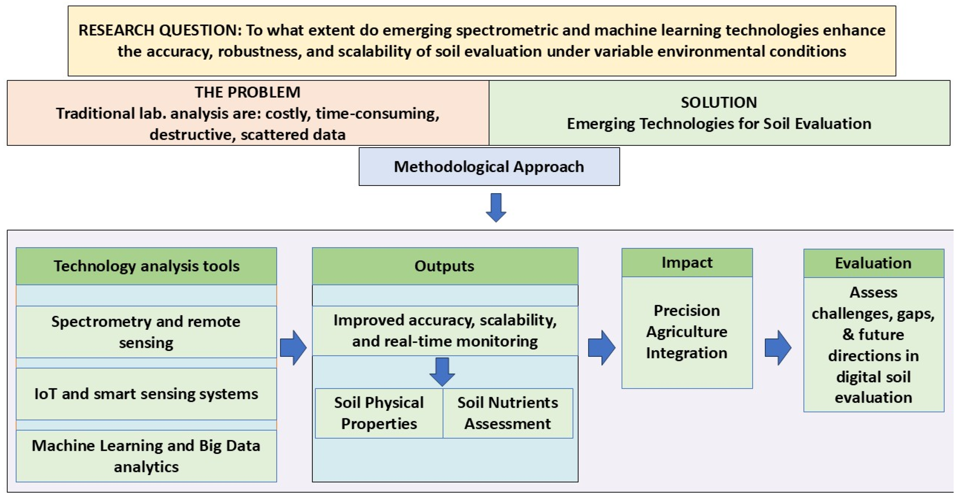
A structured overview of the review approach is provided in Table 2, which details the inclusion, exclusion, and classification criteria. The relationships between the analyzed technologies are further illustrated by the conceptual framework in Figure 1.

3. Synergistic Integration of IoT Frameworks and Spectroscopic Sensing and Machine Learning in High-Resolution Soil Characterization

The integration of novel machine learning frameworks and data-driven modeling paradigms into advanced soil sensing architectures offers the opportunity to fundamentally restructure the governance of agricultural soil health [4]. These networks provide high-frequency, continuous data streams encompassing critical edaphic parameters (volumetric water content, pH dynamics, and spatiotemporal nutrient fluxes), enabling precise, real-time modulation of irrigation and fertigation protocols [5]. By integrating ML frameworks and big data analytics, emerging sensing platforms transition from passive observation to predictive diagnostic tools capable of modeling soil behavior under fluctuating environmental conditions. Such modeling approaches enable custom agronomic interventions that enhance both the spatial resolution and the reliability of soil management protocols [6,7]. Integrating deep learning with Explainable Artificial Intelligence (XAI) frameworks further identifies non-linear latent variables within the soil–plant continuum, ultimately promoting sustainable pedological health and reducing the ecological footprint of traditional farming systems. The selection of an Explainable Artificial Intelligence (XAI) framework is motivated by the need to enhance the transparency and interpretability of machine learning models used in soil assessment. While a wide range of AI and machine learning frameworks are available, many high-performance models operate as “black boxes,” limiting their practical applicability in domains where understanding model decisions is essential. XAI approaches enable the interpretation of model outputs by quantifying the contribution of input variables (e.g., spectral features, soil parameters, environmental factors) to predictions. This is particularly important in agricultural and environmental applications, where decision-making must be supported by interpretable and scientifically consistent evidence. Therefore, the adoption of XAI is not driven by a specific implementation framework, but by the functional requirement to improve model explainability, trust, and usability.
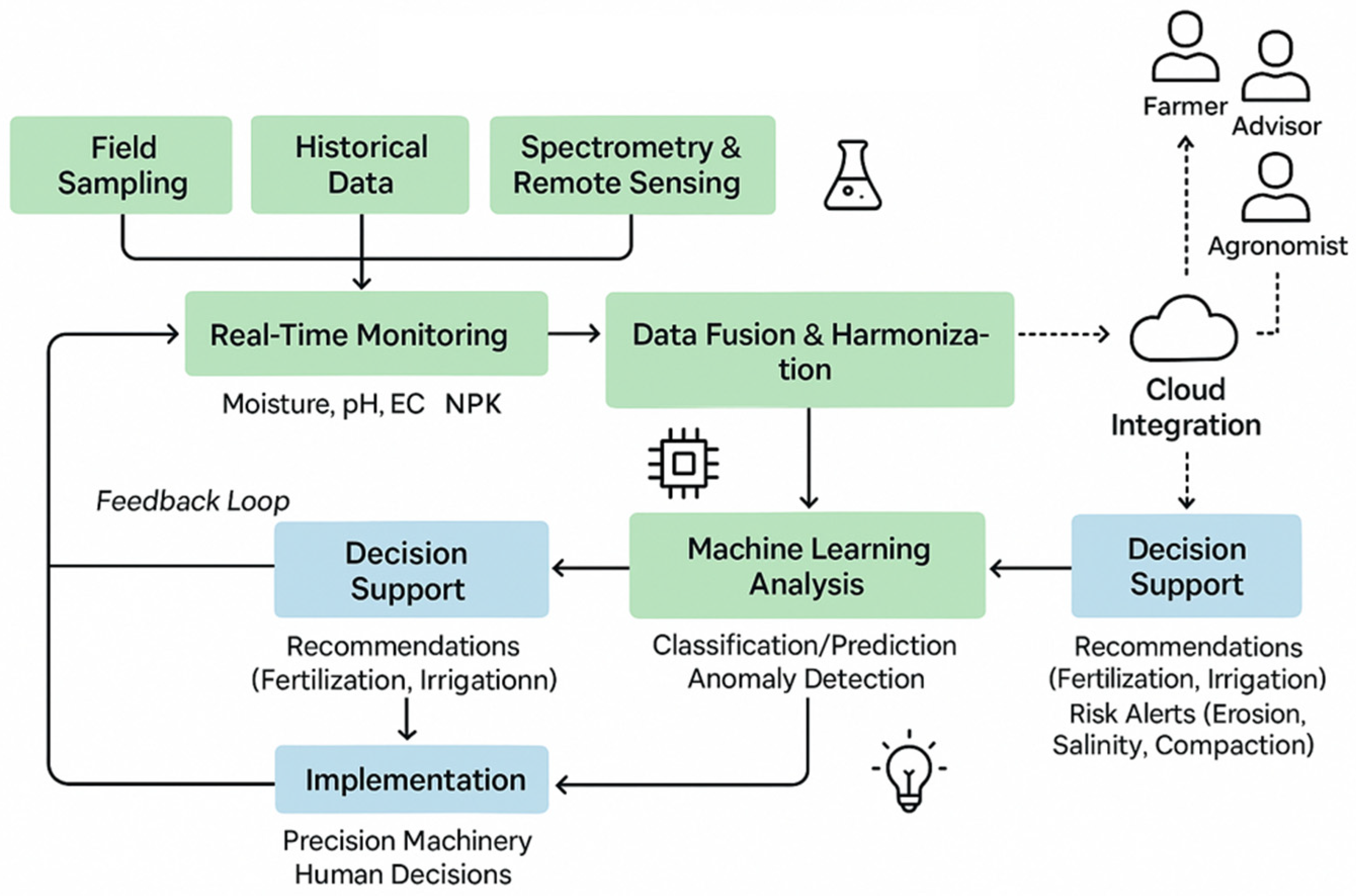
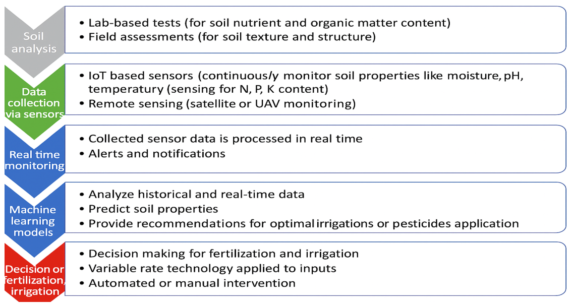
Figure 2 illustrates this integrated soil evaluation process, connecting key stages from initial sampling to real-time decision-making.

3.1. Spectrometry and Remote Sensing

Non-invasive spectrometry and remote sensing technologies enable the real-time assessment of key soil properties essential for optimizing agricultural practices. These approaches provide farmers with valuable insights into soil nutrient levels and physical characteristics, facilitating more efficient input management and supporting the transition toward sustainable agriculture.
Spectrometry (particularly near-infrared (NIR) and mid-infrared (MIR) techniques) allows for rapid identification and quantification of essential soil nutrients, such as nitrogen (N), phosphorus (P), and potassium (K), as well as organic matter content. These techniques work on the principle of measuring how light interacts with soil particles, providing detailed information about the chemical composition of the soil. NIR and MIR spectrometers are often mounted on mobile platforms or drones, enabling in-field assessments on a large-scale. A research study showed a validated application of AI (Artificial Intelligence)-driven models in mobile platforms, enabling real-time analysis of soil nutrients and physical characteristics [10]. This kind of mobility provide real-time, site-specific data collection, significantly improving decision-making in areas like fertilization and crop rotation [11]. Another research study demonstrated the versatility of NIR spectroscopy in accurately determining soil nutrient content, moisture levels, and organic matter. The study also highlighted its integration into agricultural systems for real-time monitoring, enabling precise interventions and sustainable resource management [12]. In another study, the researchers made the integration of Vis-NIR (visible and near-infrared) and XRF (X-ray fluorescence) spectra for soil attribute estimation, using machine learning techniques, (Partial Least Squares Regression—PLSR) as the primary algorithm to integrate and analyze the data from the two spectroscopic methods [13]. One of the major benefits identified for spectrometry is its ability to provide immediate feedback on soil lack of nutrients, so that precision fertilization will be applied, improving crop performance over time.
Visible and near-infrared (VNIR) and mid-infrared (MIR) spectrometric techniques offer numerous advantages; however, they also present several limitations that constrain their applicability and operational precision. Their sensitivity to soil moisture is a considerable challenge as it can dramatically alter spectral signatures and compromise the accuracy of calculations of organic matter or nutrients. Additionally, these techniques necessitate site-specific calibration models constructed on substantial, well-annotated datasets, which might not be easily accessible in every location or kind of soil. Furthermore, because VNIR and MIR devices can only evaluate the topmost soil layer and cannot reach deeper strata, they may overlook subsurface data that is crucial for thorough fertility assessments. Accessibility for non-specialists is further restricted by operational complexity and the requirement for sophisticated statistical or machine learning methods to understand spectral data. Furthermore, small-scale farmers and institutions may find it difficult to afford high-resolution or hyperspectral sensors, particularly those built into UAVs or satellite platforms. These difficulties highlight how crucial it is to combine spectrometry with other sensing modalities and data fusion techniques to improve precision agriculture robustness and application. While spectrometry provides detailed chemical composition analysis, emerging sensor-based methods allow for continuous, real-time monitoring of soil conditions.
Remote sensing technologies, including satellite platforms and unmanned aerial vehicles (UAVs), are valuable tools for the spatiotemporal assessment of soil properties across extensive geographic scales. By leveraging multispectral and thermal imagery, these systems facilitate the precise quantification and predictive modeling of soil moisture regimes, thermal dynamics, and organic matter content. Remote sensing provides a comprehensive view of spatial variability in soil conditions, when integrated with geographic information systems (GIS), allowing farmers to identify problematic areas, like zones with nutrient deficiency or affected by water stress. This information is crucial for precision agriculture, which aims at localized interventions to optimize resource use and to improve overall crop performance [14]. Remote sensing technologies complement spectrometry, offering a broader view of soil health at macro-level. Satellites are equipped with multispectral or hyperspectral sensors which work by detecting specific wavelengths of light reflected from the Earth’s surface, allowing them to measure changes in soil properties over time. Multispectral imaging typically captures data in a limited number of spectral bands (e.g., red, green, blue, and near-infrared), while hyperspectral imaging captures hundreds of narrow spectral bands, providing more detailed information about different soil characteristics [15].
UAVs, or drones, are increasingly being used in precision agriculture due to their flexibility and ability to capture high-resolution data over specific areas of interest on the agricultural field. Drones equipped with advanced cameras and sensors can fly at low altitudes, providing detailed information about some soil conditions that are otherwise difficult to monitor at ground level. For instance, UAVs can be programmed to fly over large agricultural fields, capturing thermal, multispectral, or hyperspectral images, which are afterwards analyzed to detect moisture stress, nutrient deficiencies, or soil erosion. This data is vital for irrigation schedule adjustments, optimization of fertilizer application, and prevention of crop failure.
Combining spectrometry and remote sensing techniques offers a robust framework for modern soil evaluation, enhancing the accuracy and efficiency of soil management strategies and thus supporting sustainable agricultural practices. As these technologies are evolving, they are expected to further reduce environmental impact while increasing productivity through their integration into precision farming systems.
Both spectrometry and remote sensing techniques have become critical tools in precision agriculture, enabling farmers to evaluate and monitor soil properties on a granular level and across large geographic areas.
Integration of remote sensing data with geographic information systems (GIS) further enhances soil management precision. GIS allows professionals to map the soil properties spatial variability and implement site-specific management strategies. For example, GIS can provide a detailed view of how soil conditions vary across different parts of a farm, overlaying remote sensing data with field boundaries, irrigation systems, and crop yields. This will enable targeted interventions, such as applying more water or fertilizer to areas which are nutrient deficient or water stressed [16].
Beyond its role in visualizing spatial variability, GIS has been successfully applied in several case studies to support specific agricultural decisions. A research study [16] implemented a GIS-based model in Egypt to evaluate soil quality and land suitability across different agroecological zones. By integrating satellite-derived indicators with soil physical and chemical data, they produced high-resolution maps that supported land-use planning for sustainable agricultural expansion. Another research utilized GIS and remote sensing to monitor soil degradation and nutrient loss in the Mediterranean region [14]. Their findings enabled the identification of critical zones suffering from erosion and salinity, which informed targeted remediation strategies. Several studies combined GIS with multi-sensor remote sensing to map the spatial distribution of nitrogen, phosphorus, and potassium (NPK) across various croplands. Their results demonstrated the utility of GIS in guiding site-specific fertilization practices, reducing input waste, and improving nutrient use efficiency. These examples highlight the value of GIS in transforming soil and environmental data into actionable insights for precision agriculture and sustainable land management [14,15,16].
In addition to efficiency improvement, these technologies may also contribute to agricultural practice sustainability, reducing the fertilizer and water over-application. Providing precise information about where and when inputs are needed, spectrometry and remote sensing are minimizing farming environmental negative impact, such as nutrient runoff into bodies of water and soil degradation.

3.2. IoT and Smart Sensing Systems in Modern Agriculture

Adoption of Internet of Things (IoT) technologies and development of smart sensors have dramatically transformed the way soil properties are being monitored in modern agriculture. IoT-based soil monitoring systems enable real-time collection of data directly from fields, providing valuable insights about monitored factors, and allowing for timely and precise adjustments in agricultural management. These systems are based on networks of interconnected sensors placed in or on the soil, measuring various parameters, like moisture levels, temperature, pH, and nutrient concentrations, which are then transmitted wirelessly to a central platform for processing and analysis. Direct soil sensors include ion-selective electrodes for nitrate and potassium detection, capacitive moisture sensors, and solid-state pH probes. These sensors are typically embedded at root-zone level and transmit real-time data on nutrient concentrations and soil water status to IoT platforms.
Smart sensors (which are often part of IoT systems) are providing farmers with critical data, helping in making informed decisions on crop management through precise irrigation and fertilization. These sensors are designed to be low-cost, energy-efficient, and capable of continuous operation in the field, even under harsh environmental conditions. Soil moisture sensors, for example, measure volumetric water content in the soil, helping farmers to optimize irrigation by providing real-time data on the soil’s water needs. Thus, water waste is reduced, ensuring that crops receive the right amount of water at the right time [10,17].
Sensors measuring nutrients content are also integral to IoT-based soil monitoring systems. These sensors can detect the presence and concentration of key nutrients for plants development, such as nitrogen, phosphorus, and potassium (NPK), allowing for precise application of fertilizers. Using smart sensors to ensure that nutrients are applied where they are needed most helps reduce over-fertilization, minimizing nutrient runoff into surrounding ecosystems [18]. Integration of pH sensors in the IoT-based soil monitoring systems further enhances the ability to monitor soil acidity, which is crucial for maintaining optimal growing conditions for various crops.
IoT-enabled software and hardware platforms which aggregate data from multiple sensors provide a comprehensive view of soil parameters which reflect the soil health, allowing farmers to monitor parameters trends over time. These platforms typically feature user-friendly interfaces where data is visualized in real time, enabling quick decision-making. Soil behavior could be predicted using advanced algorithms and machine learning models integrated into these platforms, allowing for proactive management strategies that further optimize agricultural outcomes. McBratney (2005) discusses the future directions of precision agriculture, emphasizing the need for spatial and temporal data integration to enhance decision-making processes [19].
IoT-driven irrigation automation leverages the synergy between soil moisture data and predictive meteorological models to optimize water application. This closed-loop approach mitigates the inefficiencies of manual scheduling, resulting in enhanced water use efficiency (WUE). The system’s capacity to account for edaphic variability (e.g., soil texture) and crop phenology ensures a customized delivery mechanism that addresses localized hydro-requirements [20]. Given that water availability is the fundamental constraint in dryland agriculture, the adoption of such precision management strategies is essential for maximizing biomass production while simultaneously conserving depleted aquifers.
The optimization of nutrient management is a critical domain where IoT sensor integration provides substantial benefits. Conventional fertilization strategies often lack precision, resulting in the excessive application of agrochemicals and subsequent nutrient leaching or surface runoff, which drive environmental degradation. In contrast, real-time nutrient sensors facilitate variable rate application (VRA), allowing for the delivery of fertilizers in precise quantities at specific locations. This targeted approach enhances plant vigor while minimizing the ecological footprint of agricultural activities, thereby advancing sustainable intensification goals [21].
Studies show that IoT platforms allow for remote monitoring of soil conditions, particularly valuable in large agricultural operations, where manual monitoring is time-consuming and labor-intensive. These platforms often feature dashboards that provide time series visual representations of soil data, with options to identify trends. For instance, if soil pH levels begin to deviate from optimal range of a particular crop, the system can alert the farmer to take corrective actions before crop health is compromised [22].
Despite numerous advantages of using IoT and smart sensors, their adoption faces several challenges. Although these sensor networks are designed for continuous field deployment, they typically require periodic calibration—especially pH and nutrient sensors—to ensure long-term measurement accuracy under varying soil and environmental conditions. Cost remains a significant barrier, particularly for smallholder farmers based in developing countries. Although this technology has the potential to enhance productivity, initial investment in sensors, network infrastructure, and data management platforms could be prohibitive. There is also the connectivity issue, as many rural farming areas lack reliable internet access, which is very important for effective operation of IoT systems [23]. Low-cost sensor networks and alternative connectivity solutions such as LoRaWAN (Low Power Wide Area Networks) are being developed to overcome these challenges and to make IoT technology more accessible to a broader range of farmers [24].
Beyond infrastructure and financial constraints, user adoption represents a significant barrier. Effective deployment of IoT networks often requires a degree of technical expertise and digital literacy, which may be limited, particularly among smallholders or older farmers. Without adequate training and support, even affordable and technical sound systems may fail to achieve their intended impact. Ensuring usability, offering hands-on training, and engaging farmers during the system design phase are key to increasing acceptance and long-term engagement [23].
One of the major advantages of IoT-enabled soil monitoring systems is the ability to perform continuous and automated data acquisition through distributed sensor networks. These systems enable real-time collection of high-frequency data on soil and environmental conditions, significantly reducing manual sampling efforts and improving temporal resolution. However, while data collection is increasingly efficient, the transformation of raw sensor data into usable datasets for machine learning remains a critical challenge [24].
A key limitation lies in the data labeling process, which is essential for supervised machine learning model development. Accurate labeling typically requires laboratory analyses, expert knowledge, or ground-truth measurements, making it one of the most labor-intensive and time-consuming stages in the data pipeline. In soil assessment, this involves linking sensor or spectral data with reference measurements (e.g., nutrient content, organic carbon), which are costly and often limited in spatial and temporal coverage. As a result, large volumes of IoT-generated data remain underutilized due to insufficient labeled datasets.
This imbalance between data acquisition and data annotation represents a major bottleneck in the practical deployment of IoT and machine learning systems in agriculture. While IoT technologies significantly enhance data availability, the lack of scalable labeling strategies limits model performance and generalization. Addressing this issue requires the development of alternative approaches, such as semi-supervised learning, transfer learning, and the integration of domain knowledge, to reduce dependence on fully labeled datasets. Therefore, the effectiveness of IoT-enabled soil monitoring systems depends not only on sensing capabilities but also on efficient data curation and labeling processes [25].

3.3. Machine Learning and Big Data Analytics

Machine Learning (ML) serves as a foundational pillar of Artificial Intelligence (AI), providing the computational framework necessary to discern complex data patterns and facilitate autonomous reasoning and decision-making. The discipline has undergone a significant transformation over the last several decades, transitioning from early symbolic logic and decision-tree architectures to the contemporary dominance of sophisticated neural networks and Deep Learning (DL) paradigms. Beyond supervised frameworks, the field has seen substantial maturation in Reinforcement Learning (RL) and unsupervised methodologies. More recently, the convergence of massive datasets and enhanced computational power has positioned Transfer Learning (TL) and self-supervised learning as primary research frontiers.
Machine learning algorithms have a major role in predicting soil behavior and optimizing agricultural practices. Algorithms such as support vector machines (SVMs), Random Forests, and artificial neural networks (ANNs) are modeling soil properties based on large datasets collected through different sensors, satellites, and/or field sampling. These models can predict key soil parameters evolution such as moisture, pH, organic carbon levels, and nutrient availability. These models can quickly analyze new data once trained, enabling real-time decision-making. For example, an ANN trained on historical soil data could be predicting nutrient deficiencies and recommending targeted fertilizer applications to reduce input costs [10].
Creation of detailed soil maps is one of the most practical applications of machine learning for soil analysis. These maps, generated using classification algorithms such as Random Forests or k-nearest neighbors, segment large agricultural fields into areas based on soil properties variations. As a result, nutrient-deficient zones could receive higher concentrations of fertilizer, compared to well-nourished areas which may require less. Such zoning helps avoiding the over-application of inputs.
Machine learning models can also be employed to minimize the negative environmental farming impact. These models reduce the over-application of inputs through precise prediction of when and where fertilizers or water are needed, minimizing nutrient leaching into groundwater, and reducing greenhouse gas emissions from fertilizers. Additionally, these technologies could identify areas with soil erosion or degradation risks, allowing for preventive measure implementation before significant damage occurs. Integration of soil analysis with sustainability metrics ensures that farming practices contribute to long-term environmental health, maintaining the same amount of productivity.
Integration of machine learning with IoT-based soil sensors leverages the benefits of both technologies. For instance, machine learning models could analyze sensor data in real time, detecting anomalies in soil moisture or nutrient levels, automatically adjusting schedules of irrigation or fertilization, minimizing over-irrigation or nutrient runoff. A novel IoT-based approach for real-time monitoring and analysis leverages data-driven insights to recommend optimal crop types and fertilizer applications [21]. This system exemplifies the advancements in Precision Farming 4.0 by combining IoT, data analytics, and machine learning for sustainable and efficient agricultural management [21,26].
Machine learning (ML) techniques have been successfully applied in soil evaluation, achieving notable improvements in predicting soil properties and producing detailed soil maps [27]. Numerous studies have demonstrated that ML models can accurately estimate key soil attributes such as organic carbon content, pH, and texture, and even forecast crop yields based on soil and environmental data [27,28]. For instance, integrating remote sensing with ML has enabled digital soil mapping at high spatial resolution, supporting precise management decisions in agriculture [29,30]. However, not all deployments are equally effective: ML models are highly data-dependent and may overfit or perform unreliably when applied outside the domain of their training datasets [27,29]. A region-specific soil model, for example, showed significantly reduced predictive accuracy when transferred to a different area with contrasting soil conditions [29], highlighting persistent challenges related to data sparsity, poor model generalizability, and the need for local calibration [27,30].
Big data analytics plays a central role in modern soil evaluation by enabling the processing and interpretation of vast and heterogeneous datasets [27,29,31]. These data originate from multiple sources, including soil sensors, remote sensing systems, weather forecasts, and historical crop performance records [27,32]. In the context of precision agriculture, big data analytics facilitates the integration of these datasets to identify spatial and temporal patterns in soil conditions and predict resource needs with high accuracy [31,33]. It encompasses the “four Vs”: Volume (large-scale data from sensors and satellites), Variety (structured and unstructured data types), Velocity (real-time data streams), and Veracity (data reliability and uncertainty) [32]. By leveraging these capabilities, big data tools allow for the generation of detailed soil maps, site-specific fertilization strategies, and irrigation schedules tailored to local conditions [27,29,33]. Moreover, when combined with machine learning algorithms, big data analytics enhance predictive modeling, uncovering relationships between soil health, climate variables, and crop responses that are difficult to detect using conventional analysis methods [28,30,34]. This data-driven approach supports intelligent decision-making, increases input efficiency, and strengthens long-term sustainability in precision agriculture systems [27,33].
Integration of machine learning (ML) and big data analytics into soil analysis is transforming modern agriculture, providing more accurate and scalable solutions for soil evaluation. These technologies enable large dataset processing, uncovering patterns and relationships in soil properties which were previously difficult to identify through conventional methods. Agricultural scientists and farmers can gain deeper insights into soil health, nutrient management, and crop yield optimization through leveraging machine learning algorithms. Machine learning models could be used to forecast soil conditions, predict crop yields, and suggest optimal management strategies for specific soil types and regions. Neural networks can be trained using historical soil data to predict how nutrient levels evolve over time, incorporating variables such as climate, crop type, and previous input applications. For instance, a research study developed a self-supervised spectral–spatial attention-based transformer network that used UAV-based hyperspectral imagery to accurately predict nitrogen levels in crops. Their deep learning model demonstrated high precision in nitrogen assessment across different field conditions, offering an effective tool for optimizing fertilizer application and improving crop management [26]. In some cases, deep learning models were employed to analyze complex, non-linear relationships between soil properties and environmental conditions. These models offered a higher degree of accuracy in predicting future soil conditions, which is particularly useful in regions where soil parameters fluctuate due to climatic changes [34].
In the deployment of machine learning and big data technologies for soil analysis, a few challenges remain. For instance, availability of high-quality training data is critical for the accuracy of models’ predictions. In many regions such data are scarce or incomplete. Moreover, the complexity and cost of implementing these advanced data platforms may limit their accessibility to smallholder farmers. Addressing these challenges will be key to ensure that the benefits of these technologies can be implemented on a global scale [35].
The machine learning (ML) and big data application in soil analysis extends beyond just prediction and classification, contributing significantly to overall improvement in soil management strategies, crop productivity, and environmental sustainability. As agricultural data volume increases, these technologies enable more sophisticated and scalable approaches to manage soil health, providing farmers better tools for decision-making.
Machine learning models used in soil assessment exhibit distinct capabilities and limitations that influence their suitability for different applications. Support vector machines (SVMs) have been widely applied in earlier studies due to their effectiveness in handling high-dimensional spectral data and relatively small datasets. They are particularly robust in non-linear classification and regression tasks. However, SVM models are sensitive to kernel selection and parameter tuning, have limited scalability for large datasets, and provide low interpretability, which reduces their relevance in current large-scale, data-rich soil monitoring systems.
In contrast, ensemble learning methods, particularly Random Forest (RF) and boosting algorithms such as XGBoost, LightGBM, and CatBoost, offer strong predictive performance and robustness across a wide range of soil conditions. Their key capabilities include handling non-linear relationships, resistance to overfitting (especially in RF), and the ability to process heterogeneous and multi-source datasets. Boosting models are especially effective in improving prediction accuracy through iterative error correction. However, these methods also present limitations, including increased computational cost, sensitivity to hyperparameter tuning (particularly in boosting), and reduced transparency as model complexity increases [36].
Deep learning models, such as convolutional neural networks (CNNs), provide advanced capabilities for processing high-dimensional inputs, including hyperspectral data and spatial imagery, by automatically extracting complex features. These models are particularly suitable for large datasets and integrated sensing systems.

3.3.1. Precision Agriculture and Data-Driven Decision-Making

Machine learning and big data analytics in soil evaluation domain are integrating vast and diverse datasets that span soil health, weather patterns, crop yields, and even market trends. The obtained result is a data-driven decision-making process tool which customize farm operations to specific conditions and needs. A machine learning model for durum wheat cultivation in Italy integrates soil and crop data to optimize fertilization strategies. The study highlighted the potential of these data-driven approaches to enhance crop productivity while minimizing environmental impact, aligning with the principles of sustainable agriculture [37]. Anoter study developed a site-specific framework to predict economic optimal nitrogen rates (EONRs) for corn production. By leveraging machine learning techniques, this approach enhanced nitrogen use efficiency, reducing input costs, and minimizing environmental impacts [38].
Moreover, big data platforms allow aggregation of datasets from different sources such as IoT sensors, drones, and/or satellite imagery, thus enabling comprehensive soil analysis. These platforms could identify and correlate relationships between soil health and crop performance, providing farmers with actionable insights to improve crop yield, maintaining, at the same time, the soil integrity. Furthermore, ensemble learning techniques, which combine the outputs of multiple models, have proven effective in accuracy improvement in soil predictions, accounting for uncertainty in soil and climate conditions.
To increase accuracy, robustness, and generalization—particularly in complex and heterogeneous datasets like those seen in soil evaluation—ensemble learning techniques aggregate predictions from several base models. Boosting (e.g., XGBoost, AdaBoost), bagging (e.g., Random Forests), and stacking are common ensemble approaches that systematically incorporate many model types. By averaging or voting over several weak learners, for example, ensemble outputs can lessen overfitting and produce predictions for soil texture or nutrients that are more consistent under different field settings. When no single model consistently performs well across all data subsets, they are especially useful. However, when numerous algorithms or deep learning components are used, ensemble models may become computationally demanding and perhaps less interpretable. Their adoption in low-resource environments or by practitioners without robust technical assistance may be hampered by this complexity. Despite these difficulties, ensemble techniques are nevertheless a useful tool for predictive modeling and digital soil mapping because, when well-constructed, they provide a reasonable trade-off between complexity and performance [39,40,41].

3.3.2. Challenges and Ethical Considerations

Despite its numerous advantages, usage of machine learning and big data for soil analysis is not without challenges. One major concern regarding this matter is availability of high-quality data. Machine learning models are only as good as the data they are fed and trained on, and many agricultural regions—particularly those in developing countries—lack comprehensive actualized datasets necessary for accurate soil predictions. Another issue is represented by data privacy and ownership; as farms become more connected, the question of who owns the data generated by soil sensors and other devices arises. An ongoing challenge is to ensure that farmers maintain control over their own data while benefiting from advanced analytics [42].
Furthermore, there are some environmental and ethical concerns around the over-reliance on data-driven models, because while these models could optimize agricultural practices, they are not always accounting for all the complexities of soil biology or ecosystem dynamics. Therefore, there is a need for continued research which will ensure that data-driven precision agriculture will remain sustainable in the long term and will not inadvertently harm soil biodiversity or ecosystem health.
The advancements discussed in soil evaluation techniques highlight the shift from conventional, labor-intensive methods to modern, technology-driven approaches. To summarize their key characteristics, applications, and limitations, Table 3 presents a comparative overview of the primary soil evaluation techniques covered in this section.
The techniques summarized in Table 3 have demonstrated varied levels of performance across real-world scenarios. For example, VNIR spectrometry has been successfully applied for predicting soil organic carbon with high accuracy, particularly when calibrated with region-specific datasets.
To ensure a consistent and objective comparison of soil sensing technologies, it is necessary to move beyond qualitative descriptors and adopt a set of explicit evaluation metrics [27]. In this context, the performance of different approaches can be assessed based on several key criteria: (i) temporal efficiency, expressed as analysis time per sample or acquisition frequency; (ii) spatial resolution, defined by sampling density or measurement granularity; (iii) predictive accuracy, commonly quantified using statistical indicators such as the coefficient of determination (R2), root mean square error (RMSE), or mean absolute error (MAE); (iv) operational cost, including equipment, labor, and maintenance requirements; and (v) scalability and field applicability, reflecting the ability to deploy the technology across different spatial scales and environmental conditions. Table 4 presents soil assessment technology evaluation, based on quantitative performance metrics and application domains.
A parametric evaluation of these criteria enables a more nuanced assessment of technological suitability. For instance, laboratory analyses remain essential for calibration, validation, and regulatory applications, where accuracy is critical. Proximal sensing techniques are particularly suitable for field-scale monitoring and precision agriculture, where high-resolution spatial data are required.
However, its performance tends to decline under conditions of high soil moisture or surface residue, which interfere with spectral readings [43]. Similarly, IoT-based soil sensor networks have shown great promise for real-time monitoring and decision-making in precision irrigation systems [44], yet they often require regular maintenance and recalibration to avoid sensor drift and data inconsistencies [45]. Remote sensing combined with ML models has produced accurate spatial predictions of soil texture and moisture, but reliability may drop in areas with dense vegetation or cloud cover [30]. These examples illustrate that while each method brings notable strengths, their effectiveness depends heavily on local conditions, calibration, and implementation context. Machine learning and big data are revolutionizing soil analysis, making agriculture more precise, efficient, and sustainable. These technologies provide the tools needed for predictive soil management, optimizing input usage and maintaining long-term soil health. As the availability of high-quality agricultural data improves and the cost of implementing these technologies decreases, machine learning and big data are expected to become even more integral to global food security efforts.
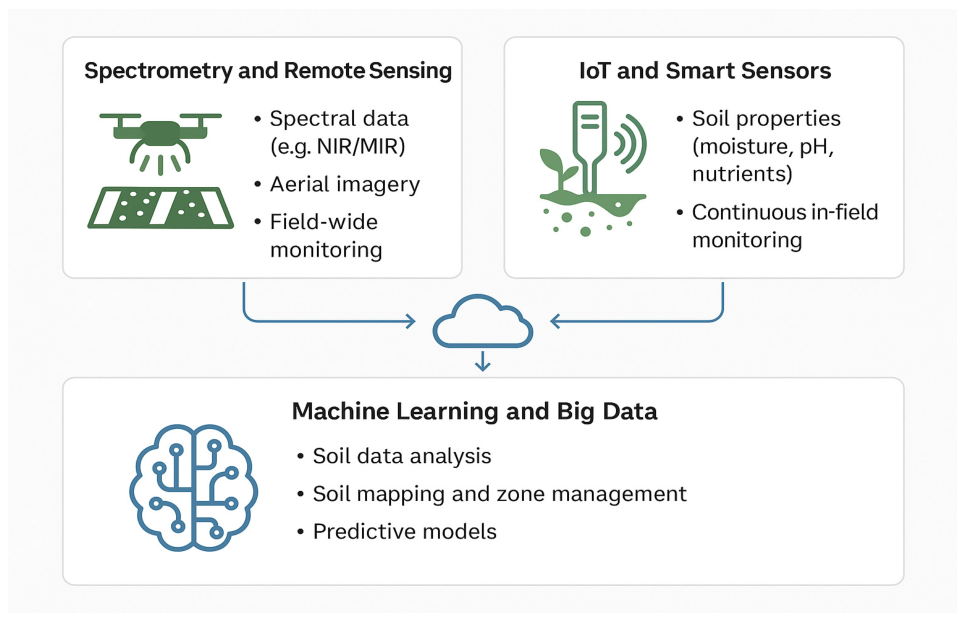
The integration of spectrometry, IoT-enabled sensors, and machine learning into soil evaluation processes enables a comprehensive, data-driven approach to precision agriculture. To illustrate how these technologies interact and contribute to real-time soil monitoring and analysis, the conceptual diagram in Figure 3 presents their core functions and the data flows between them. Spectrometry and remote sensing provide large-scale environmental data, IoT sensors offer continuous in-field measurements, and machine learning transforms this data into actionable insights—all converging through cloud platforms that support adaptive, site-specific soil management strategies.
Future developments in soil evaluation methods are anticipated to concentrate on improving accessibility, accuracy, and integration, building on recent developments. For spectrometers and sensor technologies to be widely adopted, especially by smallholder farmers, they must be made smaller and less expensive. More thorough and context-aware soil diagnostics will be possible with the continued integration of multi-source data into centralized platforms, such as spectral imagery, in-field sensor outputs, meteorological, and topography data. Machine learning developments, particularly in the areas of deep learning and federated learning, will enhance predictive modeling in a variety of data-poor and heterogeneous scenarios [42]. The establishment of standardized, open access soil data repositories may hasten the development of cooperative studies and models. Lastly, in order to guarantee farmer data privacy, data usage transparency, and fair gains from digital agriculture systems, new initiatives must also take ethical frameworks into account. Together, these approaches facilitate the shift to sustainable, intelligent, and scalable soil management techniques.
The technologies discussed in this section provide the foundational framework for modern soil evaluation by enabling integrated, high-resolution data acquisition and analysis. However, their practical relevance is best understood through their application to specific categories of soil properties. In this context, soil evaluation can be broadly divided into chemical and physical domains, each requiring tailored sensing strategies and analytical approaches. The following sections build upon the presented technological framework by examining how these integrated systems are applied to the assessment of soil nutrients and physical properties, respectively [43].

3.4. Multi-Source Data Fusion, Synchronization, and Standardization in Soil Evaluation Systems

The proper integration of spectrometric sensing, IoT-based monitoring, and machine learning requires a robust framework for multi-source data fusion, capable of handling heterogeneous, high-frequency, and spatially distributed datasets. In soil evaluation systems, data is acquired from multiple sources, including proximal spectrometers, in situ sensors, remote sensing platforms, and auxiliary datasets such as weather and topographic information. Multi-source data fusion in soil assessment is generally implemented at three levels: data-level, feature-level, and decision-level fusion, each providing different trade-offs between information preservation and robustness. Feature-level and decision-level fusion approaches are increasingly used in soil applications due to their ability to reduce noise and improve predictive performance. Studies have demonstrated that combining spectral, remote sensing, and auxiliary data sources significantly enhances model accuracy and stability for predicting soil organic matter (SOM), pH, lime buffer capacity (LBC), as well as concentration of phosphorus (P), potassium (K), calcium (Ca), magnesium (Mg), and aluminum (Al) [43].
Temporal synchronization also represents an important component of integrated soil monitoring systems. Since IoT sensors generate continuous high-frequency data, while remote sensing and spectrometric measurements are often acquired intermittently, synchronization mechanisms such as timestamp alignment and interpolation are required. These approaches are essential for accurately capturing dynamic soil processes, particularly for variables such as soil moisture and nutrient fluxes, where temporal variability plays a crucial role. A study investigated the use of data fusion from two proximal soil sensing methods (Vis-NIR and XRF) to improve the prediction accuracy of several soil attributes such as pH, organic carbon, and various minerals for precision agriculture [44]. The most effective results were achieved through data fusion. Specifically, an SF-CNN approach proved superior for most attributes, notably improving predictions for magnesium, pH, and sodium. These findings suggest that integrating multiple sensors via deep learning provides more reliable high-resolution soil data, enabling more precise and efficient site-specific farming decisions.
Data standardization and interoperability are fundamental for scalable soil evaluation systems. The integration of heterogeneous datasets requires preprocessing steps such as normalization, calibration transfer, and unit harmonization. Standardized data structures and metadata frameworks facilitate interoperability across platforms and improve reproducibility. Integrating proximal and remote sensing data via complex fusion pathways significantly improves the assessment of soil properties by leveraging the strengths of different methods to overcome individual constraints [45].
From an application perspective, multi-source data fusion has been shown to significantly improve the prediction of key soil properties, including soil organic carbon and nutrient content, by leveraging complementary information from different sensing modalities. Compared with the results obtained from single sensor model, SF models showed improvement in the prediction performance for all studied attributes, except for OC, Mg, and K prediction [46].
Despite these advances, challenges remain related to data heterogeneity, synchronization, and model transferability, which require further research and the development of standardized frameworks.

3.5. Integrated Applications of Spectrometry, IoT, and Machine Learning

While the previous sections describe spectrometry, IoT systems, and machine learning as individual components, their true potential emerges through integrated application frameworks. Integrated systems using proximal Vis–NIR spectroscopy coupled with IoT-based sensor networks and machine learning models have been successfully applied for the prediction of soil organic carbon and moisture content, achieving coefficients of determination depending on calibration strategy and environmental conditions. A study evaluated the use of visible and near-infrared (Vis-NIR) spectroscopy combined with machine learning (ML) algorithms to predict soil fertility-related properties in two contrasting agroecological regions covering a spectral range of 350–2500 nm. Predictive models that were developed using PLSR, Random Forest, support vector machines, and neural networks, achieved for OM the strongest test-set accuracy (R2 > 0.70), while pH and texture fractions showed moderate performance (R2 = 0.42–0.67). Furthermore, mobile nutrients including phosphorus, potassium, and sodium showed limited predictive accuracy due to their weak spectral expression [47].
Similarly, a research study evaluated the effectiveness of Sentinel-2, Landsat-8/9, and UAV-based hyperspectral data in estimating soil moisture content (SMC) across diverse land covers using five machine learning algorithms. Findings reveal that UAV hyperspectral data consistently outperformed satellite sources due to superior spatial and spectral resolution, with Gaussian Process Regression (GPR) achieving the highest accuracy (R2 = 0.89). While all platforms performed best on bare soil compared to cropland and grassland, Landsat-8/9 proved more accurate than Sentinel-2 for satellite-based estimation. Ultimately, integrating UAV spectroscopy with machine learning offers a precise, high-resolution complementary tool to satellite monitoring, with significant potential to optimize irrigation and sustainable agricultural decision-making.
Findings reveal that UAV hyperspectral data consistently outperformed satellite sources due to superior spatial and spectral resolution, with Gaussian Process Regression (GPR) achieving the highest accuracy (R2 = 0.89). While all platforms performed best on bare soil compared to cropland and grassland, Landsat-8/9 proved more accurate than Sentinel-2 for satellite-based estimation. Ultimately, integrating UAV spectroscopy with machine learning offers a precise, high-resolution complementary tool to satellite monitoring, with significant potential to optimize irrigation and sustainable agricultural decision-making [48]. Another study used satellite data from Landsat-8, GF-1, and GF-4 to estimate SMC using Random Forest, Linear Regression, and Extra Tree. More accurate SMC estimates were found at depths of 0.03 and 0.1 m than at 0.2 m, particularly in highly vegetated areas [49]. Using a UAV with thermal, RGB, and multispectral sensors, a research study [50] showed that SMC estimation was most accurate in corn fields in areas with 20–40% canopy cover.
A research study established a high-accuracy universal processing scheme for estimating soil moisture content (SMC) in arid regions using UAV hyperspectral imagery and machine learning. By evaluating 70 topsoil samples alongside six spectral pretreatments and four optimal 2D spectral indices, the research found that non-linear machine learning frameworks significantly outperformed traditional linear models. Specifically, the Random Forest (RF) algorithm proved superior to the Extreme Learning Machine (ELM), with the optimal model achieving an R2 of 0.907, an RMSEP of 1.477, and an RPD of 3.396. The resulting predictive maps demonstrated high spatial fidelity to measured field observations, confirming that combining preprocessed spectral indices with RF models provides a robust, scalable solution for precision agroecosystem management in water-scarce environments [51]. Another research explored the integration of UAV-based hyperspectral imaging and advanced AI algorithms for soil texture mapping and stress detection in agricultural settings. Other studies evaluate multimodal data fusion and machine learning for large-scale, cost-effective soil moisture content (SMC) estimation using UAV platforms. By integrating RGB, multispectral, and thermal sensors, the researchers found that data fusion significantly enhances predictive accuracy, particularly at soil depths of 10–20 cm. The Random Forest Regression (RFR) algorithm emerged as the superior model, achieving an R2 of 0.78 and a relative error as low as 9.6% when combining all three sensor types. Notably, while crop cultivars did not significantly impact results, canopy coverage was identified as a critical variable, with optimal accuracy achieved at moderate coverage levels (0.2–0.4). These results confirm that UAV-based multimodal fusion provides a robust and repeatable framework for precision irrigation and soil health monitoring [52].
Another study also evaluated a UAV-based multispectral imaging system for estimating corn leaf chlorophyll content across multiple vegetative growth stages. By applying twelve nitrogen rates and utilizing machine learning, researchers found that an epsilon support vector regression (ε-SVR) model with sequential forward feature selection achieved superior performance, yielding an R2 of 0.87 and an RMSE of 2.26 SPAD units. The results demonstrated consistent model accuracy across the V8, V9, V11, and V12 stages, indicating that airborne multispectral data can effectively replace labor-intensive handheld sensors. Ultimately, this high-resolution mapping approach provides a robust framework for timely nitrogen management and informed decision-making in precision corn production [53]. Proximal soil sensors make it easier to quickly and affordably gather accurate, quantitative, high-resolution data that may be utilized to gain a better understanding of the temporal and geographical variability of soil [54]. Another study proposed a two-stage spatiotemporal reconstruction framework to address persistent cloud cover gaps in satellite-derived NDVI time series, particularly in tropical regions. By combining spatiotemporal filling with multistep temporal smoothing, the method outperformed benchmark techniques like Savitzky–Golay filters in reconstruction accuracy. When applied to Sentinel-2 data across 2460 rice field sites, the framework significantly improved growth phase classification, increasing F1-scores by up to 21%. These results highlight the system’s robustness for near-real-time agricultural monitoring in challenging, cloudy environments [55].
From a feasibility perspective, the combined use of these technologies is characterized by near real-time data acquisition, high spatial resolution (sub-meter to meter scale), and scalable deployment, although it also introduces challenges related to data synchronization, calibration transfer, and system cost. Overall, integrated approaches consistently outperform isolated technologies by leveraging complementary data sources, resulting in improved predictive accuracy, robustness, and decision support capability. These findings confirm that the integration of spectrometry, IoT, and machine learning represents a practical and effective pathway for advancing soil monitoring systems in precision agriculture.

3.6. Data Standardization and Interoperability in Soil Monitoring Systems

An important aspect that remains insufficiently addressed in current soil monitoring frameworks is the lack of standardized data structures and unified parameter definitions. The heterogeneity of soil data—arising from differences in measurement protocols, sensor types, spatial scales, and regional practices—limits the interoperability and reuse of datasets across studies. Developing a unified standard for soil parameter collection and data structuring would significantly enhance comparability and integration of datasets generated in different agro-environmental contexts. Such standardization should include harmonized definitions of soil variables, consistent units of measurement, metadata descriptors (e.g., location, depth, sampling conditions), and interoperable data formats [55].
The adoption of common data standards would enable the aggregation of large, geographically diverse datasets, facilitating more robust machine learning models and improving their transferability across regions and soil types. Moreover, it would support collaborative research efforts, allowing scientists and practitioners to share, compare, and reuse data more effectively. Therefore, the development of standardized frameworks for soil data collection and management represents a critical step toward advancing integrated, data-driven soil assessment systems at both local and global scales.

4. Soil Nutrient Assessment

The assessment of soil nutrient dynamics is fundamental to evaluate soil fertility and informing strategic fertilizer management, aimed at maximizing agricultural productivity. Modern precision agriculture necessitates the high-resolution quantification of both macronutrients (e.g., N, P, K) and essential micronutrients (e.g., Zn, Fe, Cu). Accurate characterization of these parameters ensures that nutrient application is precisely aligned with the physiological requirements of specific crops, thereby optimizing vegetative growth and reproductive yield. Building upon the integrated sensing and data-processing framework described in the previous section, this chapter focuses on the application of these technologies to soil nutrient assessment. Spectrometric techniques, IoT-based sensors, and machine learning models are considered here in the context of chemical soil properties, particularly macronutrients and micronutrients, highlighting their role in enabling precise and data-driven fertilization strategies.
Traditional assessment methods of soil nutrients, such as testing of soil samples within laboratory, remain extremely valuable for their precision, although they are often labor-intensive and time-consuming. Recent advancements in sensors technology and spectrometry have revolutionized soil nutrient analysis, providing valuable real-time, in situ data which allows for immediate intervention and a more efficient nutrient management. Techniques like near-infrared (NIR) and mid-infrared (MIR) spectrometry, as well as portable soil testers and kits, offer rapid, cost-effective alternatives for nutrient analysis across large fields [56].

4.1. Macronutrient Evaluation

Macronutrients evaluation represents a key factor in assessing soil fertility and determining optimal fertilization strategies in agriculture. These nutrients are vital for plants growth, each playing a distinct role in achieving that. Nitrogen is crucial for leaf and stem development, phosphorus supports root growth and flowering, and potassium enhances overall plant health by regulating water and nutrient movement within plant tissues [57].
Nitrogen (N) represents the most commonly deficient nutrient in soils, because it is rapidly lost through leaching, volatilization, and crop uptake. Traditionally, nitrogen content has been measured through laboratory-based techniques such as Kjeldahl method or ion-selective electrodes. However, newer technologies enable now real-time nitrogen monitoring. For example, NIR spectrometry could assess nitrogen levels through analysis of light absorption patterns related to organic matter in soil, providing a method quick and non-invasive for farmers, who could adjust nitrogen application in real time [58]. Additionally, ion-selective sensors are integrated into IoT platforms, allowing for continuous nitrate concentrations in soil monitoring [59]. Advancements in deep learning have enabled accurate prediction of crop nitrogen status using UAV imagery. A research developed a self-supervised spectral–spatial attention-based transformer network that automates nitrogen prediction with high precision. This method leveraged UAV imagery to analyze nitrogen status efficiently, offering a robust tool for optimizing fertilizer applications and enhancing crop management [60]. Usage of optical sensors which can measure chlorophyll content in plant leaves provides indirect but highly accurate nitrogen readings. These sensors, often mounted on drones or tractors, provide data for assessing the Normalized Difference Vegetation Index (NDVI), which correlates with plant nitrogen status. Another study demonstrated the effectiveness of NDVI in predicting these key indicators across wheat genotypes, offering insights for precision management of water and nutrient applications [61].
Furthermore, hyperspectral imaging is increasingly being used for nitrogen detection, capturing detailed spectral data from plants and enabling detection of nitrogen deficiencies which are not yet visible to the naked eye. Analyzing specific wavelengths associated with nitrogen content, these hyperspectral sensors provide early detection capabilities [62,63].
In addition to optical sensors, IoT-based systems are also employed for real-time nitrogen monitoring. A research study developed and tested a variable fertilization system that adapts fertilizer application rates based on detected soil nutrient levels, improving efficiency and reducing environmental impact [60,64].
Phosphorus (P) is a nutrient less mobile in soil compared to nitrogen, which makes its management challenging due to its tendency to bind with soil particles, especially in soils with high clay content. Traditionally, phosphorus is measured using colorimetric methods such as Bray or Olsen tests [65,66]. Recent advancements in portable spectrometers enabled in-field phosphorus evaluation, with immediate data collection without laboratory delays. These devices analyze soil samples reflectance spectra, estimating phosphorus availability and helping to prevent both under- and over-application of phosphorus fertilizers. Phosphorus detection was made more accessible through recent advancements in electrochemical sensors. These sensors can detect phosphate ions in soil, offering real-time data that allows for phosphorus inputs immediate adjustment. The sensors are particularly beneficial in precision phosphorus management, ensuring that this nutrient is applied where needed the most and avoiding phosphorus buildup, which could contribute to eutrophication in nearby water bodies [63,64].
Isotopic tracing in phosphorus cycling represents an emerging technology which helps us understand the bioavailability of phosphorus in different soil types [65], offering strategies for phosphorus recovery from organic sources, such as compost and manure, thus promoting more sustainable nutrient recycling practices.
Potassium (K), essential for plant metabolic processes, particularly in regulating water uptake and enzyme activation, has been traditionally measured through flame photometry or atomic absorption spectrometry. Similarly to the previously presented macronutrients, in recent years, handheld spectrometers and portable ion-selective electrodes have made potassium assessment more accessible to farmers. These technologies measure potassium ion activity in soil, allowing for rapid, in situ assessments and enabling timely adjustments to potassium fertilization based on crop requirements and soil conditions [66]. Additionally, methods which integrate soil moisture sensors with potassium ion sensors provide a more comprehensive understanding of how soil moisture influences potassium availability, leading to more efficient irrigation and nutrient management strategies.
Critical for water regulation and metabolic activities in plants, potassium quantitative assessment is increasingly benefiting from ion-selective electrode technology, which allows for direct measurement of potassium ions within the soil. Potassium mobility in the soil, especially due to different moisture conditions, can now effectively be tracked using real-time data from soil sensors linked to cloud-based platforms [67]. This way, farmers have instant feedback on potassium availability, allowing them to avoid fertilizer over-application, which could lead to soil compaction and reduced water infiltration.
Particularly in arid and semi-arid regions, recent studies have demonstrated the efficacy of using satellite-based thermal infrared imaging to assess soil moisture and infer potassium needs. This technique provides valuable soil moisture variation data which directly impact potassium uptake, helping optimizing potassium usage in water-stressed environments [68,69].
One of the most promising advancements in macronutrient evaluation is integrating machine learning algorithms with sensor data. These models could analyze nutrient patterns across fields and predict future nutrient requirements based on soil type, weather conditions, and crop history. For example, support vector machines (SVMs) and Random Forest algorithms were being used to forecast nitrogen and phosphorus deficiencies, offering precise recommendations for fertilization [70]. These predictive models help reduce waste of specific fertilizers, minimize nutrients leaching, and indirectly improve overall soil health.
Support Vector Machine (SVM) is a supervised learning algorithm that classifies data by finding the optimal hyperplane that separates data points into different categories. It works well for both linear and non-linear classification problems using kernel functions, which transform the input data into higher-dimensional spaces where a clear separation is more feasible. The goal of SVM is to maximize the margin between the closest data points (support vectors) of different classes, thereby improving the model’s generalization. Random Forest (RF) is an ensemble learning method that builds multiple decision trees during training and merges their outputs (through majority voting for classification or averaging for regression) to improve accuracy and reduce overfitting. Each tree is constructed using a random subset of the training data (bootstrapping) and a random selection of features at each split, which introduces diversity among the trees. SVM and RF have been increasingly applied in the estimation and classification of soil nutrient levels. These models are particularly effective when trained on large datasets comprising spectral reflectance, soil sensor readings, and environmental covariates. For example, RF has been used to predict soil organic carbon, total nitrogen, and available phosphorus with high accuracy, outperforming linear regression models, especially in heterogeneous soils [71]. SVM has also proven effective for categorical classification of soil fertility status, especially when nutrient data are discretized into management zones or fertility classes [72]. Both models benefit from their capacity to handle non-linear relationships and noisy inputs, which are common in field-collected nutrient datasets. However, their predictive accuracy depends strongly on training dataset quality, particularly the representativeness of nutrient ranges, spatial coverage, and laboratory reference values such as Bray P1 or Olsen-extracted phosphorus. Recent studies have also shown improvements when these models are combined with feature selection techniques or when ensemble methods are used to combine predictions across multiple soil types or regions [73].

Data-Driven Fertilizer Management

Integration of big data and machine learning into macronutrient management enhances precision of fertilizer application. These technologies analyze historical soil and weather data alongside real-time sensor inputs, predicting nutrient demand patterns with a higher degree of accuracy. This predictive capacity enables more effective fertilizer budgeting, through input planning over the growing season, avoiding nutrient runoff [74]. Continuous improvement in algorithms and access to larger datasets will likely increase accuracy, facilitating global adoption of these methods across agricultural sectors.
While macronutrients are critical for plant growth, deficiencies in micronutrients such as iron, zinc, and copper can significantly impact crop metabolism, enzyme activity, and overall productivity. Their precise assessment is essential for balanced soil fertility.

4.2. Micronutrient Evaluation

While macronutrients are fundamental to plant structural development, micronutrients—including iron (Fe), zinc (Zn), copper (Cu), manganese (Mn), and boron (B)—are equally indispensable for mediating key physiological and metabolic functions. Despite their requirement in trace amounts, micronutrient deficiencies can act as primary limiting factors, resulting in substantial yield gaps. Consequently, the systematic evaluation and management of the soil micronutrient profile are imperative for maintaining crop vigor and ensuring long-term agroecosystem sustainability.
Iron is a micronutrient essential for chlorophyll formation and enzyme activation in plants. Traditional iron analysis has relied on chemical extraction methods, such as DTPA (diethylenetriaminepentaacetic acid) extraction, which provides an estimate of plant-available iron in the soil. In the present, portable X-ray fluorescence (XRF) spectrometry has enabled iron content in situ measurements. These portable devices analyze iron atom-emitted fluorescence when exposed to X-rays, offering real-time assessments of iron availability in the field [75,76]. Additionally, electrochemical sensors are now being used to detect iron ion concentrations in soil. In soils with high pH, characterized by often limited iron availability, these sensors allow for more precise iron fertilization strategies. For example, Anguiano (2012) developed a modified glassy carbon electrode incorporating Multiwall Carbon Nanotubes, Polyaniline, and platinum nanoparticles, which demonstrated high selectivity and sensitivity for detecting ionic iron [77]. The sensor exhibited a linear response in the range of 0 to 10 mM, with detection and quantification limits of 0.003 and 0.012 μM, respectively. These electrochemical tools have been successfully applied to analyze iron concentrations in lixiviated solutions of polluted soils, providing a reliable method to assess soil erosion and iron availability [78].
Zinc is a key micronutrient for enzyme activation, protein synthesis, and overall plant development [79]. It is often deficient in alkaline soils, which reduces its bioavailability to crops. Traditional methods for zinc evaluation involve soil extraction tests (such as the DTPA extraction method), followed by atomic absorption spectrometry (AAS) or inductively coupled plasma (ICP) analysis within laboratory. Recent advancements in analytical techniques have improved the precision of zinc measurements. Proton-Induced X-ray Emission (PIXE) has emerged as a highly sensitive and non-destructive method for assessing zinc concentrations in soil samples. According to a research study [80], PIXE analysis provides rapid and accurate zinc detection with detection limits as low as 2 µg/g, making it suitable for real-time evaluations in field conditions. The proposed method demonstrated strong linear correlation with traditional Instrumental Neutron Activation Analysis (INAA), highlighting its reliability for soil nutrient assessments.
Copper (Cu), manganese (Mn), and boron (B) are constituents of plant phytosanitary health, with their quantification generally following analytical protocols. Traditionally, Cu concentrations are determined via chemical extraction followed by Inductively Coupled Plasma (ICP) spectroscopy; however, emerging electrochemical sensing technologies now facilitate continuous, in situ monitoring of Cu levels. This transition allows for real-time data acquisition, bypassing the temporal lags associated with conventional destructive sampling. These sensors provide real-time data, which are useful in maintaining the delicate balance between copper sufficiency and toxicity. Manganese (Mn) is a micronutrient essential for plant photosynthesis, and could also be monitored using similar spectrometric and electrochemical techniques. Portable X-ray fluorescence (PXRF) devices allow on-the-spot measurements, their precision for soil micronutrient assessment showing significant potential. When measured ex situ, PXRF provides strong correlations with certified reference materials (CRMs), achieving R2 values ≥ 0.96, showing high accuracy under controlled conditions. For copper (Cu) and zinc (Zn), detection limits have been reported as low as 6–10 ppm, making PXRF particularly effective for detecting these critical micronutrients in agricultural soils. In the case of manganese (Mn), PXRF performs reliably when soil samples are properly prepared, with deviations often caused by soil moisture and organic matter. Organic matter can introduce corrections ranging from 0.76 to 1.34, requiring calibration for accurate readings. Similarly, heterogeneity in soil samples significantly affects iron (Fe) measurements, with variances reaching up to 52.7% in disturbed soils [81].
These modern approaches reduce labor intensity, enhance decision-making, and improve nutrient management strategies in precision agriculture. Table 5 provides a comparative overview of traditional and advanced evaluation methods for macronutrients and micronutrients, highlighting their advantages, limitations, and relevance of advanced technologies in modern agricultural practices.
While traditional laboratory methods remain highly accurate, they often require significant time and resources, making them less adaptable for real-time agricultural applications. In contrast, advanced technologies such as spectrometry, electrochemical sensors, UAV-based imaging, and machine learning-driven diagnostics provide faster, non-invasive alternatives for nutrient evaluation. These modern approaches facilitate more precise nutrient management, reducing fertilizer overuse, minimizing environmental impact, and improving crop yields.

5. Assessment of Soil Physical Soil Properties

While the previous section addressed the application of integrated sensing technologies to soil chemical properties, particularly nutrient dynamics, the present chapter extends this framework to the assessment of soil physical properties. Parameters such as texture, structure, moisture, and compaction require different sensing approaches and analytical methods, yet they rely on the same underlying technological integration of spectrometry, IoT systems, and machine learning models described earlier.
The physical matrix of the soil, encompassing its granulometry and structural arrangement, directly governs critical processes such as hydraulic conductivity, nutrient transport, and soil strength. Parameters like bulk density and compaction levels serve as key indicators of aeration porosity and root penetration resistance. In the context of precision farming, high-resolution spatial data regarding these physical properties are essential for calibrating variable-rate applications (VRAs) and site-specific soil management strategies to mitigate environmental stress. Assessment of these properties is vital for efficient soil management and sustainable agriculture, because they influence water infiltration, root penetration, and nutrient availability [85]. Traditionally, physical soil properties have been measured through manual methods, but nowadays advancements in sensors and technology have introduced more efficient, real-time assessment tools.
With a focus on methods pertinent to digital soil monitoring and precision agriculture, this chapter explores current developments in the assessment of physical soil characteristics. A focused search of peer-reviewed journal articles published in the past ten years was used to choose the reviewed literature, with an emphasis on studies that used sensor-based, non-destructive, or remote sensing techniques to evaluate characteristics like soil texture, bulk density, moisture, compaction, and aeration. Experimental studies involving comparative performance analysis, field validation, or integration with geospatial data systems were preferred. To highlight technological trends, operational constraints, and practical consequences for soil monitoring in both research and farm-level contexts, the following sections synthesize findings rather than summarize each source separately.

5.1. Soil Texture and Structure Analysis

Soil texture and structure significantly influence water retention, nutrient availability, root penetration, and overall soil health. Soil texture refers to relative proportions of sand, silt, and clay particles within the soil. Soil texture is determined through manual methods like hydrometer method or particle size analysis using sieves, for separation of particles based on size. However, these conventional methods can be labor-intensive and time-consuming. Modern techniques, such as laser diffraction and image analysis, offer more rapid and precise evaluations of soil texture. Laser diffraction uses laser beams to measure the size distribution of soil particles, obtaining high-resolution results. According to Callesen (2023), laser diffraction (LD) provides reliable soil texture analysis for sandy soils with replication errors below 3%, but it underestimates clay content by up to 24% and overestimates silt by up to 30% compared to traditional methods, showing greater variability in loamy and clayey soils [86]. This technique acquires more consistent data, eliminating human error and reducing the amount of time required for analysis. Additionally, automated image analysis systems capture detailed images of soil samples, which are then software processed to classify the particles based on size and shape. These will provide accurate particle distribution maps, useful for understanding how texture varies within fields [87,88]. A study proposed a Blackbox prototype machine that analyzes soil texture under controlled conditions, achieving an impressive accuracy of 99.5%. By leveraging image processing and training on soil samples mapped to the USDA texture triangle, this model offers a rapid, cost-effective alternative for soil texture classification, revolutionizing crop and fertilizer recommendations [89]. Portable X-ray fluorescence (pXRF) spectrometry has emerged as a powerful tool for predicting soil fertility in conjunction with soil texture analysis. Investigations demonstrated that pXRF effectively predicts nutrient concentrations, particularly in sandy soils, providing rapid, non-destructive assessments. The study reported strong correlations between pXRF data and conventional laboratory methods, highlighting its suitability for real-time soil analysis in the Brazilian Coastal Plains [88]. Laser-Induced Breakdown Spectroscopy (LIBS) combined with machine learning has proven effective for soil texture classification. A research model using LIBS data with various input formats, including raw spectra and relative intensities, achieving optimal results with relative intensity (Iλ/I553nm). Among the tested classifiers, the Naïve Bayes model performed best, with F1-scores of 0.93 for clay, 1.00 for sandy clay (SC), and 1.00 for sand, emphasizing the role of plasma reflection phenomena in enhancing classification accuracy for different soil textures [90].
Soil structure refers to arrangement of soil particles into aggregates that form the pore spaces through which air and water are moving. The soil structure can influence soil fertility, because it influences plants root penetration, water retention, and microbial activity. Traditionally, soil structure has been assessed visually or by examining soil cores. X-ray computed tomography (CT scanning) is one of the most advanced methods for analyzing soil structure. This non-destructive technique allows for detailed 3D visualization of soil aggregates and pore networks, giving valuable information about soil porosity, bulk density, and compaction levels. Recent studies using X-ray CT achieved spatial resolutions as fine as 2–5 times the voxel size, providing accurate insights into pore geometry, hydraulic conductivity, and root–soil interactions [91]. For instance, soil cores scanned at resolutions of 10–50 μm reveal intricate macropore networks and structural changes under varying soil compaction levels, highlighting the method’s high precision and relevance in modern soil analysis. CT scanning has become increasingly important for precision agriculture, helping to identify structural issues that may inhibit root growth or water movement. Additionally, micro-CT scanning allows for even finer resolution, offering detailed insights into the microstructure of soil aggregates and helping researchers to better understand how soil structure impacts crop growth. Micro-CT analysis has demonstrated that combined organic and inorganic fertilization (NPKOM) promotes larger pore formation in upland red soil, increasing porosity for pores > 0.098 mm by 7.6–9.5 times compared to no fertilization (CK) or chemical fertilization alone (NPK) [92].
Remote sensing technologies, including multispectral and hyperspectral imaging, are also being employed to infer soil texture and structure indirectly. For example, spectral reflectance patterns allow precise analysis of soil fertility, while advancements in remote sensing integration with geospatial tools optimize land-use planning and soil management strategies [93]. These technologies, although less precise than conventional direct soil sampling methods, offer the advantage of scalability, allowing monitoring of large agricultural areas over time. Remote sensing is particularly useful for identifying areas with high variability, such as zones with high compaction or poor structure, which can then be scouted for more detailed, in-field analysis. For example, an unsupervised classification approach utilizing the ISODATA algorithm on Sentinel-2 satellite imagery successfully identified 15 distinct land cover classes, providing insights into the spatial heterogeneity of the Livezile-Dolat Protected Area in Timis County, Romania. The study revealed significant variability in vegetation indices such as NDVI, SAVI, and CIgreen, with coefficients of variation ranging up to 80.4% for GLI, highlighting its potential for detailed land characterization and precision agriculture applications [93].
A growing trend in soil analysis is the integration of machine learning algorithms with data collected from sensors and remote sensing technologies. Machine learning models can process large datasets and potentially identify patterns in soil texture and structure that might not be immediately apparent through traditional analysis methods. For instance, models can be trained to predict soil texture variations across fields based on multispectral imagery, soil moisture readings, and historical data. Machine learning models, such as Random Forest, outperformed traditional multiple linear regression methods for predicting soil texture and organic carbon content. In a study conducted in South-Western Burkina Faso, machine learning models achieved higher accuracy with R2 values up to 0.85 for soil texture, underscoring the effectiveness of remote sensing variables for detailed soil property mapping and precision agriculture applications [94].
Furthermore, by analyzing long-term datasets, specific machine learning models can predict changes in soil structure over time due to influencing factors such as compaction, erosion, or organic matter depletion. A research study applied seven machine learning models, including Random Forest, XGBoost, and ANN, to evaluate gully erosion susceptibility in the Tensift catchment, Morocco. The study identified XGBoost and KNN as the most effective models, achieving AUC-ROC values of 0.96 and 0.93, respectively [95]. Unlike single-threshold metrics such as accuracy or precision, AUC–ROC evaluates the trade-off between true positive rate and false positive rate across all possible decision thresholds, offering a more comprehensive measure of model discrimination capability. This is especially relevant in soil assessment applications where class distributions (e.g., soil quality categories or contamination levels) may be uneven. While numerous alternative metrics exist, AUC–ROC is adopted due to its robustness, interpretability, and suitability for comparing models under varying classification thresholds. Nevertheless, it is complemented by other metrics depending on the specific prediction task.

5.2. Moisture and Water Retention

Soil moisture content and water retention capacity are critical physical properties that directly affect plant growth and nutrient uptake [96,97]. Proper moisture management of agricultural soils ensures that plants are receiving sufficient water for metabolic processes, while preventing issues such as waterlogging or drought stress. Optimization of irrigation practices through evaluating and managing soil moisture levels will improve crop yields, and maintain long-term soil sustainability.
Traditional soil moisture measurement methods, such as gravimetric analysis and volumetric water content (VWC) determination, have been widely used for decades [98]. Gravimetric method involves collecting soil samples, weighing them, drying them in an oven, and then weighing them again to determine by subtraction the water content. Although highly accurate, this method is labor-intensive, time-consuming, and provides only a measure of the soil moisture at the time of sampling. Gravimetric and Time Domain Reflectometry (TDR) methods provide valuable insights into volumetric water content (VWC) in soils. Another research evaluated these methods in a biochar and nitrogen fertilizer field experiment. The study found that TDR’s accuracy in measuring VWC decreased with increased nitrogen fertilizer applications due to higher soil salinity. Specific calibration reduced measurement differences, narrowing the variation from 5% to 2% when compared to the gravimetric method [99]. The versatility of TDR for quantifying soil water content and electrical conductivity, with its accuracy influenced by soil texture, bulk density, and temperature was also evaluated. This study emphasized the importance of proper calibration, especially in heterogeneous soils, to achieve reliable results for hydrological and agricultural applications [100]. TDR works by sending an electrical pulse through electrodes inserted into the soil and measuring the time it takes for the pulse to reflect back. Signal speed is influenced by the soil water content, thus calculating soil moisture levels. TDR equipment can be expensive, and its range is limited to specific points where probes are installed [101].
IoT-enabled soil moisture sensors are becoming increasingly popular due to their ability to provide continuous, real-time data on soil water content. Some of these sensors, often installed throughout a field, measure the dielectric constant of the soil, which varies with moisture levels. The data is then transmitted wirelessly to a central system, thus monitoring moisture levels remotely [102,103].
Capacitance and resistance-based sensors are two types of soil moisture sensors widely used in agriculture. Capacitance sensors measure the soil ability to hold electrical charge, correlated with its water content, while resistance-based sensors measure the electrical resistance between two electrodes buried in the soil. Both technologies are highly effective for real-time monitoring and are often integrated into automated irrigation systems that adjust watering schedules based on current soil moisture conditions [104].

Water Retention and Field Capacity

Water retention property is largely determined by soil texture and structure and refers to the soil’s ability to keep water after excess water drained away. Usually, soils with a higher clay content tend to have greater water retention capacity compared to sandy soils. Irrigation needs of crops are derived after assessing field capacity (water retained in the soil after water has drained by gravitational means) and wilting point (when plants can no longer extract water from the soil).
Tensiometers are the tools used to measure the soil’s water potential, providing information about how strong water is retained by soil particles. According to Shock and Wang (2011), tensiometers measure soil water tension most accurately in the range of 0 to 80 kPa, making them ideal for monitoring soil moisture in sandy and loamy soils, where irrigation management is critical [104]. This tool helps farmers determine when irrigation is necessary in order to keep optimal soil humidity levels for crop growth. IoT-based tensiometers, providing real-time readings of soil water potential, are used in precision agriculture, where optimal-irrigation is key.
Remote sensing technologies, such as satellite imaging, drone-mounted multispectral cameras, and thermal infrared cameras, have advanced moisture monitoring, allowing for large-scale assessments of soil humidity. Multispectral and thermal infrared sensors can detect humidity variability across large areas by measuring soil surface temperature and reflectance. In fields where moisture related stress is identified, farmers can apply additional irrigation, improving water use efficiency [105,106].
While traditional soil moisture assessment methods rely on direct sampling, recent advancements such as ground-penetrating radar (GPR) offer high-resolution subsurface moisture mapping. This non-invasive technology detects moisture variations at different depths, allowing for more precise irrigation management. GPR functions by sending radar waves into the ground and measuring the reflected signals to determine the water content at various depths. This technology is particularly useful for identifying moisture variability within the soil profile, helping in tackling deeper soil moisture deficits which are not detectable through surface-level methods [107].
The integration of machine learning and big data analytics with soil moisture sensors in recent years had improved soil humidity management. Machine learning models could process and analyze historical soil moisture data, weather patterns, and crop growth stages and yields to predict more accurately the crop’s irrigation needs. These models are helpful in optimizing water use by scheduling irrigation, when necessary, thereby reducing water consumption and the risk of over-irrigation, which could lead to problems like root diseases or nutrient leaching [108].
Sustainable agriculture is dependent on accurate monitoring and management of soil humidity and increasing of water retention capacity. Because water resources are becoming increasingly scarce all over the world, precision irrigation systems which function based on real-time soil moisture data could significantly reduce water losses. These systems not only conserve water but also improve crop health, ensuring that plants receive the right amount of water at the right time [109,110].

5.3. Soil Compaction and Aeration

Soil compaction and aeration are physical properties which influence root growth, water infiltration, and soil microbial activity. Compaction occurs when soil particles are pressed together, reducing the space available for air and water to move through the soil. This can have significant negative effects on crop yields because of root penetration limitation and restriction of water movement. Aeration, on the other hand, refers to the amount of air space between soil particles, a property essential for oxygen exchange and microbial activity, both of which are vital for healthy plant growth.

5.3.1. Soil Compaction Evaluation for Agricultural Soils

Soil compaction significantly impacts both soil health and efficiency of agricultural machinery A recent study [111] highlights the detrimental effects of soil compaction on both machinery performance and soil quality. It underscores the need for frequent monitoring and targeted interventions to prevent long-term soil degradation. Compaction can be caused by repeated use of heavy machineries especially on wet soils, conventional tillage practices, or by livestock trampling. Effects of soil compaction include poor water infiltration, reduced root penetration, and limited access to soil nutrients. To assess soil compaction, traditional methods such as visual examination and the Proctor test have been commonly used, these methods being labor-intensive and often not precise enough for large-scale agricultural applications.
Penetrometers and compaction meters are more practical, field-based tools used to assess soil compaction levels. These tools measure the force required to penetrate the soil, characterizing soil compaction, which can affect root development and water infiltration. Many of these tools are now integrated with GPS technology, allowing the mapping of compaction levels across agricultural fields, and the taking of corrective actions in specific areas rather than applying uniform tillage practices.
Another measuring technology is the use of electromechanical sensors to measure soil compaction continuously. These sensors are integrated into farming machinery, providing real-time data on soil resistance as equipment moves through the field. This enables a more dynamic response to compaction—agricultural machinery being programmed to adjust its weight distribution or tilling depth based on soil conditions [112,113]. Ground-penetrating radar (GPR) technologies can detect variations in soil’s density, identifying compaction patterns without the need for extensive on-the-ground sampling. These tools can also detect subsurface compaction, which is harder to identify using surface-based methods [114]. Integrating remote sensing data with geospatial analysis can create detailed maps of compaction zones across agricultural fields, allowing for targeted interventions such as deep ripping or reduced traffic in high-compaction areas.

5.3.2. Soil Aeration in Agricultural Soils

Proper soil aeration is essential for respiration of plant roots and soil microorganism activity, which contribute to nutrient cycling. Aeration issues often arise as a consequence of compaction, because compacted soils have fewer air-filled pores, leading to anaerobic conditions that hinder root growth and reduce microbial efficiency. Core sampling has been used to evaluate soil aeration, analyzing soil pore space.
Air permeability testing [115] is a commonly used method to measure soil aeration, evaluating the ease with which air passes through soil pores. Recent advancements in IoT-enabled soil aeration sensors offer continuous monitoring of soil air permeability, transmitting real-time data to cloud platforms.
Tensiometers and oxygen diffusion rate (ODR) meters are also used to measure soil aeration indirectly, monitor soil moisture levels, and soil oxygen content, respectively. Tracking these parameters allow for a better understanding of how soil conditions affect aeration and could suggest practices such as aerating the soil mechanically or adjusting irrigation schedules to improve oxygen availability [116]. The comparison in Table 6 highlights the strengths and weaknesses of both traditional and modern soil physical property assessment methods.
While advanced measurement techniques offer greater efficiency and scalability, their cost and accessibility may still be limiting factors, particularly for small-scale farmers.

6. Integration of Advanced Soil Evaluation Techniques into Precision Agriculture

Precision agriculture, by definition, integrates advanced technologies and data-driven practices to optimize resources usage and enhance crop productivity, promoting sustainability. The workflow process of precision agriculture is a sequential interaction between data acquisition methods (e.g., spectrometry, remote sensing, in situ sensors), data processing and analysis (including cloud platforms and machine learning models), and decision support outputs tailored to site-specific soil management that begins with initial soil analysis, where lab-based tests and field assessments establish a baseline for soil health and physical properties [116,117].
Real-time data collection represents the next stage, using IoT-enabled sensors to monitor parameters like moisture, pH, and nutrients. Complementary technologies, such as spectrometry for macronutrient analysis and remote sensing for large-scale monitoring, could provide detailed insights into soil conditions.
In the real-time monitoring phase, data is processed and displayed on dashboards, allowing farmers to track trends and receive alerts for deviations. This data is used as input for machine learning models, analyzing patterns and providing predictive recommendations for irrigation, fertilization, and/or pest control.
Finally, farmers make precise decisions on resource application using Variable Rate Technology (VRT). Automated or manual interventions ensure resources are applied efficiently, minimizing waste and environmental impact. Figure 4 illustrates a conceptual workflow for intelligent soil evaluation, connecting data collection, analysis, and decision-making steps.
Continued integration of advanced soil evaluation techniques into precision agriculture not only optimizes farming input management but also provides a framework for data-driven agricultural practices that are more adaptable to environmental conditions and resource constraints. This technological shift allows farmers to improve decision-making processes, reduce input waste, and contribute to a more sustainable farming system.

6.1. Real-Time Data Application in Fertilization and Irrigation

Real-time data is a key element in optimizing both fertilization and irrigation strategies. Precision agriculture systems, sustained by real-time soil data, use variable rate technology (VRT), where fertilizers are applied at varying rates across a field based on soil nutrient availability. This reduces the over-application of fertilizers, thus preventing nutrient leaching and mitigating the negative impact on the environment [118]. VRT has become more accessible with the advancement of IoT-based nutrient sensors and GIS mapping, which create detailed nutrients maps and prescribe site-specific fertilizer applications, critical in improving nutrient use efficiency (NUE) [119].
For irrigation, real-time soil moisture data allows for precision irrigation practices, when necessary, which is particularly important in water-scarce regions [120]. Drip irrigation systems, for example, can be controlled by real-time soil moisture sensors, in order to deliver precise amounts of water directly to plant roots, thus preventing waterlogging [121]. A combination of soil moisture monitoring with weather forecasting systems further enhances irrigation efficiency, predicting future water needs based on upcoming weather conditions.

6.2. Machine Learning and Predictive Analytics in Precision Agriculture

One of the most exciting developments in precision agriculture is integration of machine learning algorithms with soil monitoring data. These algorithms can analyze large datasets collected from various spectrometers, multi and hyperspectral cameras, IoT-based sensors and/or satellite imagery, identifying trends and making predictions that could improve decision-making. For instance, machine learning models could predict when a field will require irrigation based on soil moisture data, weather patterns, and crop growth stages as inputs for an AI model, allowing farmers to optimize water use and avoid hydric stress [122].
Regarding fertilization management, machine learning models could analyze soil nutrient levels over time in order to predict when crops will need additional nutrients, forecasting nutrient deficiencies before they occur. By leveraging deep learning for continuous model optimization, predictive accuracy is enhanced, ensuring that agrochemical inputs are applied only as required, thereby minimizing nutrient leaching and promoting sustainable agricultural stewardship [123,124].

7. Challenges, Gaps, and Future Directions in Digital Soil Evaluation

Despite the rapid advancement of spectrometry-based sensing and machine learning techniques, several critical challenges continue to limit their widespread adoption and operational reliability, especially in precision agriculture systems.
One of the most critical challenges associated with spectrometric soil evaluation techniques is their pronounced sensitivity to environmental variability, particularly soil moisture content, temperature fluctuations, and surface conditions. These factors can significantly alter spectral signatures, thereby compromising predictive accuracy and necessitating frequent recalibration of models [125]. Moreover, such variability introduces uncertainty in model outputs, especially under field conditions where environmental parameters are highly dynamic. Consequently, ensuring the robustness and stability of spectrometric models across diverse agroecological settings remains a major research priority.
Another major limitation concerns data quality and availability. Machine learning models rely heavily on large, well-annotated datasets for training and validation; however, such datasets are often scarce, region-specific, or inconsistent in terms of sampling protocols and preprocessing methods. This lack of standardized datasets hinders model comparability and limits the reproducibility of results across different studies and geographical regions [126]. Model robustness and generalization is also a persistent issue. Many machine learning models demonstrate strong performance under controlled or site-specific conditions but fail to maintain accuracy when applied to new environments with different soil types or climatic conditions. This underscores the need for more transferable and adaptive modeling approaches [127].
Integration of heterogeneous data sources, including spectrometry, IoT sensor data, and remote sensing imagery, presents both an opportunity and a challenge. While multi-sensor data fusion has the potential to enhance prediction accuracy and system resilience, the lack of standardized frameworks for data integration, synchronization, and interpretation limits its practical implementation. Interoperability between different sensing platforms and data formats remains insufficiently addressed. Another important challenge is the limited interpretability of advanced machine learning models, particularly deep learning architectures. While these models can capture complex non-linear relationships in soil data, their “black-box” nature reduces transparency and may hinder user trust and practical decision-making [128]. In this case, the internal decision-making processes remain difficult to interpret. In recent years, Explainable Artificial Intelligence (XAI) approaches have emerged as a promising solution to address this challenge by providing insights into model behavior and prediction logic. Common XAI techniques applied in environmental and soil-related studies include feature importance analysis, Shapley Additive Explanations (SHAP), and Local Interpretable Model-Agnostic Explanations (LIME). These methods enable the identification of the most influential input variables (e.g., spectral bands, soil properties, environmental covariates) and quantify their contribution to model outputs. For instance, SHAP values can reveal how specific wavelength regions influence the prediction of soil organic carbon, while feature importance metrics in ensemble models such as Random Forest can highlight the relative importance of soil moisture, texture, or topographic factors. The integration of XAI into soil assessment models offers several advantages. It enhances model transparency, allowing researchers and practitioners to better understand the relationships between input data and predicted soil properties. It could also support decision-making processes by providing interpretable evidence that can guide agronomic interventions. Despite these benefits, the application of XAI in soil science remains limited and fragmented. Most existing studies focus primarily on predictive performance, with relatively few addressing interpretability and explainability in a systematic manner. Future research should prioritize the integration of explainable models, the development of domain-specific interpretation frameworks, and the validation of XAI methods under diverse agro-environmental conditions.
In addition, the high cost and complexity of advanced sensing equipment, particularly hyperspectral sensors and integrated IoT systems, continue to pose barriers to adoption, especially for smallholder farmers. Infrastructure limitations, such as unreliable internet connectivity in rural areas, further constrain the deployment of real-time monitoring systems [129,130].
Data governance issues also emerged as relevant concern, since data ownership, privacy, and access control are becoming increasingly important as agricultural systems become more digitized and data-driven [131,132]. Ensuring that farmers retain control over their data while benefiting from advanced analytics is a key requirement for sustainable technology adoption. The linkage between soil evaluation technologies and operational decision support systems also remains underdeveloped. While many studies focus on data acquisition and modeling, fewer address how these outputs can be effectively translated into actionable recommendations for farmers and stakeholders [133,134]. Furthermore, the digitization of soil health must proactively address data governance and farmers’ rights. Ensuring data privacy and transparency is essential for building user trust and preventing the marginalization of smallholder farmers who may lack the infrastructure to benefit from these advancements. By integrating Explainable AI (XAI), practitioners can provide interpretable evidence for agronomic interventions, ensuring that automated decisions align with the ethical and practical interests of the primary data producers. While current advancements prioritize predictive accuracy, critical gaps remain in establishing standardized sharing mechanisms for soil spectral databases, which are currently hampered by inconsistent preprocessing and heterogeneous datasets. Future efforts must facilitate open access repositories to accelerate collaborative research while simultaneously addressing data bias and sample representation. Because machine learning models often lack generalizability across diverse agroecological settings, integrating domain adaptation and transfer learning is essential to correct for the data sparsity and domain shift that often limit model transferability. Furthermore, the digitization of soil health necessitates a proactive approach to data governance, ensuring that farmers’ data rights and interests are protected. This includes establishing transparent protocols for data ownership and privacy to prevent the marginalization of stakeholders—particularly smallholder farmers—who may lack the digital literacy or infrastructure to benefit equitably from advanced analytics [135].
In terms of research gaps, there is a clear lack of comprehensive, standardized evaluation frameworks that allow for consistent comparison of different soil evaluation technologies. Existing studies often employ different performance metrics, datasets, and validation strategies, making it difficult to draw general conclusions about the relative effectiveness of various approaches [136,137,138,139].
Future research should prioritize the development of robust, scalable, and transferable models capable of operating under diverse environmental conditions. This includes the exploration of domain adaptation techniques, transfer learning, and hybrid modeling approaches that combine physical knowledge with data-driven methods. Another promising direction involves the advancement of multi-sensor data fusion frameworks, enabling the integration of spectrometry, IoT, and remote sensing data into unified analytical platforms. Such approaches can improve both the spatial and temporal resolution of soil evaluation while enhancing system reliability [139]. Addressing these challenges and research gaps will be essential for unlocking the full potential of emerging soil evaluation technologies and ensuring their successful implementation in next-generation precision agriculture systems.

8. Conclusions

This review highlights the convergence of spectrometric sensing, IoT-based monitoring, and machine learning as a core innovation framework for next-generation soil assessment systems. A key consensus emerging from the literature is that integrated, data-driven approaches significantly outperform conventional methods in terms of spatial coverage, temporal resolution, and decision support capabilities. However, several controversial issues remain, particularly regarding model transferability across different soil types and regions, the trade-off between predictive accuracy and interpretability, and the dependency on large, high-quality datasets. In addition, challenges related to data heterogeneity, standardization, and system interoperability continue to limit large-scale implementation. Based on these findings, future research should prioritize (i) the development of standardized multi-source data fusion frameworks, (ii) the integration of explainable artificial intelligence to improve model transparency and trust, (iii) the design of cost-effective and scalable sensing systems, and (iv) the establishment of robust data governance models to ensure data quality, accessibility, and ethical use. These directions provide a clear pathway for advancing soil monitoring technologies toward practical, reliable, and widely adoptable solutions in precision agriculture.
Spectrometric techniques provide rapid and non-destructive assessment of soil chemical properties, while IoT sensor networks allow continuous in situ monitoring of key parameters such as moisture, pH, and nutrient levels. Machine learning models further enhance these capabilities by converting large and heterogeneous datasets into predictive insights, supporting more efficient and adaptive decision-making in precision agriculture.
Despite these advancements, several limitations remain that restrict widespread adoption and operational reliability. The performance and transferability of machine learning models are strongly influenced by data quality, calibration procedures, and environmental variability. Sensor-related challenges, including measurement drift, maintenance requirements, and sensitivity to field conditions, can affect data accuracy. In addition, economic and infrastructural barriers, along with limited technical expertise among end users, particularly in smallholder systems, continue to hinder large-scale implementation.
Future progress depends on the development of standardized and interoperable frameworks for multi-source data integration, as well as advancements in explainable and scalable machine learning approaches. Strengthening the link between technological innovation and practical application—through improved accessibility, user training, and supportive policies—will be essential. Overall, the synergistic use of these technologies represents a key pathway toward more efficient, sustainable, and resilient soil management systems in modern agriculture.

Author Contributions

Conceptualization, F.N., M.G.M. and I.G.; methodology, F.N., M.G.M. and I.G.; software, I.C.P.; validation, F.N., M.G.M., I.G. and F.B.M.; formal analysis, I.G.; investigation, I.F.V.; resources, F.N. and I.F.V.; writing—original draft preparation, F.N., M.G.M. and I.G.; writing—review and editing, F.N., M.G.M. and I.G.; supervision, F.N., M.G.M. and I.G.; project administration, F.N., M.G.M. and I.G.; funding acquisition, F.N. and I.F.V. All authors have read and agreed to the published version of the manuscript.

Funding

This research was funded by The Ministry of Education and Research, grant number PN 23 04 01 02 “Intelligent automated system designed for the georeferenced collection of soil samples” and Project PN-IV-P6-6.1-CoEx-2024-0025 “Innovative strategies for ensuring nutritional security by stimulating the exploitation of sustainable protein resources PROfutureFOOD”.

Data Availability Statement

The original contributions presented in this study are included in the article. Further inquiries can be directed to the corresponding author.

Conflicts of Interest

The authors declare no conflicts of interest.

References

  1. Aubert, B.A.; Schroeder, A.; Grimaudo, J. IT as Enabler of Sustainable Farming: An Empirical Analysis of Farmers’ Adoption Decision of Precision Agriculture Technology. Decis. Support Syst. 2012, 54, 510–520. [Google Scholar] [CrossRef] [Scilit]
  2. Fageria, N.K.; Baligar, V.C.; Jones, C.A. Growth and Mineral Nutrition of Field Crops; CRC Press: Boca Raton, FL, USA, 2010. [Google Scholar] [CrossRef] [Scilit]
  3. Jawad, H.M.; Nordin, R.; Gharghan, S.K.; Jawad, A.M.; Ismail, M. Energy-Efficient Wireless Sensor Networks for Precision Agriculture: A Review. Sensors 2017, 17, 1781. [Google Scholar] [CrossRef] [Scilit]
  4. Senapaty, M.K.; Ray, A.; Padhy, N. IoT-Enabled Soil Nutrient Analysis and Crop Recommendation Model for Precision Agriculture. Computers 2023, 12, 61. [Google Scholar] [CrossRef] [Scilit]
  5. Soussi, A.; Zero, E.; Sacile, R.; Trinchero, D.; Fossa, M. Smart Sensors and Smart Data for Precision Agriculture: A Review. Sensors 2024, 24, 2647. [Google Scholar] [CrossRef] [Scilit]
  6. Padhy, N.; Sen, A.; Kumar, R. Sustainable Soil Management: Challenges and Opportunities. PLoS ONE 2023, 18, e0308423. [Google Scholar] [CrossRef] [Scilit]
  7. Bhatti, U.A.; Masud, M.; Bazai, S.U.; Tang, H. AI-Based Smart Precision Agriculture Techniques. Front. Plant Sci. 2023, 14, 1237783. [Google Scholar] [CrossRef] [Scilit]
  8. Tey, Y.S.; Brindal, M. Factors influencing the adoption of precision agricultural technologies: A review for policy implications. Precis. Agric. 2012, 13, 713–730. [Google Scholar] [CrossRef] [Scilit]
  9. United Nations Development Programme. Precision Agriculture for Smallholder Farmers; United Nations Development Programme: New York, NY, USA, 2021; Available online: https://www.undp.org/publications/precision-agriculture-smallholder-farmers (accessed on 1 February 2026).
  10. Silva, A.F.; Ohta, R.L.; Azpiroz, J.T.; Ferreira, M.E.; Marçal, D.V.; Botelho, A.; Coppola, T.; Oliveira, A.F.M.; Bettarello, M.; Schneider, L.; et al. Artificial Intelligence Enables Mobile Soil Analysis for Sustainable Agriculture. arXiv 2022. [Google Scholar] [CrossRef] [Scilit]
  11. Metzger, K.; Liebisch, F.; Herrera, J.M.; Guillaume, T.; Walder, F.; Bragazza, L. The Use of Visible and Near-Infrared Spectroscopy for In-Situ Characterization of Agricultural Soil Fertility: A Proposition of Best Practice by Comparing Scanning Positions and Spectrometers. Soil Use Manag. 2024, 40, e12952. [Google Scholar] [CrossRef] [Scilit]
  12. Tsuchikawa, S.; Ma, T.; Inagaki, T. Application of Near-Infrared Spectroscopy to Agriculture and Forestry. Anal. Sci. 2022, 38, 635–642. [Google Scholar] [CrossRef] [Scilit]
  13. Javadi, S.H.; Munnaf, M.A.; Mouazen, A.M. Fusion of Vis-NIR and XRF Spectra for Estimation of Key Soil Attributes. Geoderma 2021, 385, 114851. [Google Scholar] [CrossRef] [Scilit]
  14. Ganga, A.; Elia, M.; Repe, B. Applications of GIS and Remote Sensing in Soil Environment Monitoring. Sustainability 2023, 15, 13705. [Google Scholar] [CrossRef] [Scilit]
  15. Misbah, K.; Laamrani, A.; Khechba, K.; Dhiba, D.; Chehbouni, A. Multi-Sensors Remote Sensing Applications for Assessing, Monitoring, and Mapping NPK Content in Soil and Crops in African Agricultural Land. Remote Sens. 2022, 14, 81. [Google Scholar] [CrossRef] [Scilit]
  16. Abdellatif, M.A.; El Baroudy, A.A.; Arshad, M.; Mahmoud, E.K.; Saleh, A.M.; Moghanm, F.S.; Shaltout, K.H.; Eid, E.M.; Shokr, M.S. A GIS-Based Approach for the Quantitative Assessment of Soil Quality and Sustainable Agriculture. Sustainability 2021, 13, 13438. [Google Scholar] [CrossRef] [Scilit]
  17. Ferentinos, K.P.; Tsiligiridis, T.A. Adaptive design optimization of wireless sensor networks using genetic algorithms. Comput. Netw. 2007, 51, 1031–1051. [Google Scholar] [CrossRef] [Scilit]
  18. Musa, P.; Sugeru, H.; Wibowo, E.P. Wireless Sensor Networks for Precision Agriculture: A Review of NPK Sensor Implementations. Sensors 2024, 24, 51. [Google Scholar] [CrossRef] [Scilit]
  19. McBratney, A.; Whelan, B.; Ancev, T.; Bouma, J. Future Directions of Precision Agriculture. Precis. Agric. 2005, 6, 7–23. [Google Scholar] [CrossRef] [Scilit]
  20. Lloret, J.; Sendra, S.; Garcia, L.; Jimenez, J.M. A Wireless Sensor Network Deployment for Soil Moisture Monitoring in Precision Agriculture. Sensors 2021, 21, 7243. [Google Scholar] [CrossRef] [Scilit]
  21. Tiwari, S.; Garg, R.; Kushal, N.; Khurana, M. IoT-Based Real-Time Crop and Fertilizer Prediction for Precision Farming 4.0. In Proceedings of the International Conference on Innovations in Computational Intelligence and Computer Vision, Jaipur, India, 13 October 2023; Springer: Singapore, 2023; pp. 695–711. [Google Scholar] [CrossRef] [Scilit]
  22. Tzounis, A.; Katsoulas, N.; Bartzanas, T.; Kittas, C. Internet of Things in agriculture, recent advances and future challenges. Biosyst. Eng. 2017, 164, 31–48. [Google Scholar] [CrossRef] [Scilit]
  23. Garcia, L.; Parra, L.; Jimenez, J.M.; Parra, M.; Lloret, J.; Mauri, P.V.; Lorenz, P. Deployment Strategies of Soil Monitoring WSN for Precision Agriculture Irrigation Scheduling in Rural Areas. Sensors 2021, 21, 1693. [Google Scholar] [CrossRef] [Scilit]
  24. Xing, Y.; Liu, X.; Wang, X. Integrating UAVs, satellite remote sensing, and machine learning in precision agriculture: Pathways to sustainable food production, resource efficiency, and scalable innovation. Front. Agron. 2026, 7, 1670380. [Google Scholar] [CrossRef] [Scilit]
  25. El-Jamaoui, I.; Delgado-Iniesta, M.J.; Martínez Sánchez, M.J.; Pérez Sirvent, C.; Martínez López, S. Assessing Soil Organic Carbon in Semi-Arid Agricultural Soils Using UAVs and Machine Learning: A Pathway to Sustainable Water and Soil Resource Management. Sustainability 2025, 17, 3440. [Google Scholar] [CrossRef] [Scilit]
  26. Nowatzki, J. Basics of LoRa Technology for Crop and Livestock Management. In North Dakota State University Extension Publication; AE1999; North Dakota State University: Fargo, ND, USA, 2021; Available online: https://www.ndsu.edu/agriculture/extension/publications/basics-lora-technology-crop-and-livestock-management (accessed on 1 February 2026).
  27. Wadoux, A.M.J.-C.; Minasny, B.; McBratney, A.B. Machine Learning for Digital Soil Mapping: Applications, Challenges and Suggested Solutions. Earth Sci. Rev. 2020, 210, 103359. [Google Scholar] [CrossRef] [Scilit]
  28. Padarian, J.; Minasny, B.; McBratney, A.B. Using deep learning to predict soil properties from regional spectral data. Geoderma Reg. 2019, 16, e00198. [Google Scholar] [CrossRef] [Scilit]
  29. Zeraatpisheh, M.; Garosi, Y.; Reza Owliaie, H.; Ayoubi, S.; Taghizadeh-Mehrjardi, R.; Scholten, T.; Xu, M. Improving the Spatial Prediction of Soil Organic Carbon Using Environmental Covariates Selection: A Comparison of a Group of Environmental Covariates. Catena 2022, 208, 105723. [Google Scholar] [CrossRef] [Scilit]
  30. Botero-Valencia, J.; García-Pineda, V.; Valencia-Arias, A.; Valencia, J.; Reyes-Vera, E.; Mejia-Herrera, M.; Hernández-García, R. Machine Learning in Sustainable Agriculture: Systematic Review and Research Perspectives. Agriculture 2025, 15, 377. [Google Scholar] [CrossRef] [Scilit]
  31. Kamilaris, A.; Kartakoullis, A.; Prenafeta-Boldú, F.X. A review on the practice of big data analysis in agriculture. Comput. Electron. Agric. 2017, 143, 23–37. [Google Scholar] [CrossRef] [Scilit]
  32. Wolfert, S.; Ge, L.; Verdouw, C.; Bogaardt, M.J. Big data in smart farming–A review. Agric. Syst. 2017, 153, 69–80. [Google Scholar] [CrossRef] [Scilit]
  33. Liakos, K.G.; Busato, P.; Moshou, D.; Pearson, S.; Bochtis, D. Machine learning in agriculture: A review. Sensors 2018, 18, 2674. [Google Scholar] [CrossRef] [Scilit] [PubMed]
  34. Delgado, J.A.; Short, N.M., Jr.; Roberts, D.P.; Vandenberg, B. Big Data Analysis for Sustainable Agriculture on a Geospatial Cloud Framework. Front. Sustain. Food Syst. 2019, 3, 54. [Google Scholar] [CrossRef] [Scilit]
  35. Khan, I.; Raghavan, V.; Hu, J. AI and Machine Learning for Soil Analysis: An Assessment of Sustainable Approaches. Bioresour. Bioprocess. 2023, 10, 90. [Google Scholar] [CrossRef] [Scilit]
  36. Vargas-Terminel, M.L.; Flores-Rentería, D.; Sánchez-Mejía, Z.M.; Rojas-Robles, N.E.; Sandoval-Aguilar, M.; Chávez-Vergara, B.; Robles-Morua, A.; Garatuza-Payan, J.; Yépez, E.A. Soil Respiration Is Influenced by Seasonality, Forest Succession and Contrasting Biophysical Controls in a Tropical Dry Forest in Northwestern Mexico. Soil Syst. 2022, 6, 75. [Google Scholar] [CrossRef] [Scilit]
  37. Zhang, J.; Kang, N.; Qu, Q.; Zhou, L.; Zhang, H. Automatic fruit picking technology: A comprehensive review of research advances. Artif. Intell. Rev. 2024, 57, 54. [Google Scholar] [CrossRef] [Scilit]
  38. Fiorentini, M.; Schillaci, C.; Denora, M. Fertilization and soil management machine learning based sustainable agronomic prescriptions for durum wheat in Italy. Precis. Agric. 2024, 25, 2853–2880. [Google Scholar] [CrossRef] [Scilit]
  39. Zhang, R.; Wang, J.; Liu, C.; Li, X.; Chen, H. Synergistic integration of metaheuristics and machine learning: Latest advances and emerging trends. Artif. Intell. Rev. 2025, 58, 268. [Google Scholar] [CrossRef] [Scilit]
  40. Dong, X.; Yu, Z.; Cao, W.; Shi, Y.; Ma, Q. A survey on ensemble learning. Front. Comput. Sci. 2020, 14, 241–258. [Google Scholar] [CrossRef] [Scilit]
  41. Wadoux, A.M.J.C.; McBratney, A.B.; Minasny, B.; Ramirez-Lopez, L. Optimal soil sampling design for calibrating soil maps based on Digital Soil Mapping. Geoderma 2021, 384, 114785. [Google Scholar] [CrossRef] [Scilit]
  42. Sarangi, A.; Raula, S.K.; Ghoshal, S.; Kumar, S.; Kumar, C.S.; Padhy, N. Enhancing Process Control in Agriculture: Leveraging Machine Learning for Soil Fertility Assessment. Eng. Proc. 2024, 67, 31. [Google Scholar] [CrossRef] [Scilit]
  43. Ben-Dor, E.; Irons, J.R.; Epema, G.F. Soil Reflectance. In Remote Sensing for the Earth Sciences; John Wiley & Sons: New York, NY, USA, 1999; pp. 111–188. [Google Scholar]
  44. Luck, J.D.; Puntel, L.A. Site-Specific Economic Optimal Nitrogen Rate Prediction Using Machine Learning for Corn Production. Precis. Agric. 2023, 24, 1018–1036. [Google Scholar] [CrossRef] [Scilit]
  45. Kaur, J.; Hazrati Fard, S.M.; Amiri-Zarandi, M.; Dara, R. Protecting Farmers’ Data Privacy and Confidentiality: Recommendations and Considerations. Front. Sustain. Food Syst. 2022, 6, 903230. [Google Scholar] [CrossRef] [Scilit]
  46. Ji, W.; Adamchuk, V.I.; Chen, S.; Su, A.S.M.; Ismail, A.; Gan, Q.; Shi, Z.; Biswas, A. Simultaneous Measurement of Multiple Soil Properties through Proximal Sensor Data Fusion: A Case Study. Geoderma 2019, 341, 111–128. [Google Scholar] [CrossRef] [Scilit]
  47. Pizarro, S.; Ccopi, D.; Ortega, K.; Contreras, D.; Ñaupari, J.; Cano, D.; Patricio, S.; Loayza, H.; Apolo-Apolo, O.E. Vis-NIR Spectroscopy and Machine Learning for Prediction of Soil Fertility Indicators and Fertilizer Recommendation in Andean Highland and Rainforest Agroecosystems. Remote Sens. 2026, 18, 1331. [Google Scholar] [CrossRef] [Scilit]
  48. Shokati, H.; Mashal, M.; Noroozi, A.; Mirzaei, S.; Mohammadi-Doqozloo, Z.; Nabiollahi, K.; Taghizadeh-Mehrjardi, R.; Khosravani, P.; Adhikari, R.; Hu, L.; et al. Comparing UAV-Based Hyperspectral and Satellite-Based Multispectral Data for Soil Moisture Estimation Using Machine Learning. Water 2025, 17, 1715. [Google Scholar] [CrossRef] [Scilit]
  49. Liu, Q.; Wu, Z.; Cui, N.; Jin, X.; Zhu, S.; Jiang, S.; Zhao, L.; Gong, D. Estimation of Soil Moisture Using Multi-Source Remote Sensing and Machine Learning Algorithms in Farming Land of Northern China. Remote Sens. 2023, 15, 4214. [Google Scholar] [CrossRef] [Scilit]
  50. Ge, X.; Wang, J.; Ding, J.; Cao, X.; Zhang, Z.; Liu, J.; Li, X. Combining UAV-Based Hyperspectral Imagery and Machine Learning Algorithms for Soil Moisture Content Monitoring. PeerJ 2019, 7, e6926. [Google Scholar] [CrossRef] [Scilit] [PubMed]
  51. Wang, Q.; Chen, X.; Meng, H.; Miao, H.; Jiang, S.; Chang, Q. UAV Hyperspectral Data Combined with Machine Learning for Winter Wheat Canopy SPAD Values Estimation. Remote Sens. 2023, 15, 4658. [Google Scholar] [CrossRef] [Scilit]
  52. Cheng, M.; Jiao, X.; Liu, Y.; Shao, M.; Yu, X.; Bai, Y.; Wang, Z.; Wang, S.; Tuohuti, N.; Liu, S.; et al. Estimation of Soil Moisture Content under High Maize Canopy Coverage from UAV Multimodal Data and Machine Learning. Agric. Water Manag. 2022, 264, 107530. [Google Scholar] [CrossRef] [Scilit]
  53. Tian, F.; Zhou, J.; Ransom, C.J.; Aloysius, N.; Sudduth, K.A. Estimating Corn Leaf Chlorophyll Content Using Airborne Multispectral Imagery and Machine Learning. Smart Agric. Technol. 2025, 10, 100719. [Google Scholar] [CrossRef] [Scilit]
  54. Rossel, R.A.V.; Adamchuk, V.I.; Sudduth, K.A.; McKenzie, N.J.; Lobsey, C. Proximal Soil Sensing: An Effective Approach for Soil Measurements in Space and Time. Adv. Agron. 2011, 113, 243–291. [Google Scholar] [CrossRef] [Scilit]
  55. Suseno, B.; Brunel, G.; Wijayanto, H.; Sadik, K.; Afendi, F.M.; Tisseyre, B. Reconstructing Satellite Temporal Series Data Under Cloudy Conditions: Application in Predicting Rice Growth Phases. Smart Agric. Technol. 2025, 12, 101378. [Google Scholar] [CrossRef] [Scilit]
  56. Stenberg, B.; Viscarra Rossel, R.A.; Mouazen, A.M.; Wetterlind, J. Visible and Near Infrared Spectroscopy in Soil Science. In Advances in Agronomy; Sparks, D.L., Ed.; Academic Press: Burlington, VT, USA, 2010; Volume 107, pp. 163–215. [Google Scholar] [CrossRef] [Scilit]
  57. Kandpal, L.M.; Munnaf, M.A.; Cruz, C.; Mouazen, A.M. Spectra Fusion of Mid-Infrared (MIR) and X-ray Fluorescence (XRF) Spectroscopy for Estimation of Selected Soil Fertility Attributes. Sensors 2022, 22, 3459. [Google Scholar] [CrossRef] [Scilit]
  58. Andrade, R.; Faria, W.M.; Silva, S.H.G.; Chakraborty, S.; Weindorf, D.C.; Mesquita, L.F.; Guilherme, L.R.G.; Curi, N. Prediction of Soil Fertility via Portable X-ray Fluorescence (PXRF) Spectrometry and Soil Texture in the Brazilian Coastal Plains. Geoderma 2020, 357, 113960. [Google Scholar] [CrossRef] [Scilit]
  59. Bhimji, W.; Farrell, S.A.; Kurth, T.; Paganini, M.; Racah, E. Deep Neural Networks for Physics Analysis on Low-level Whole-detector Data at the LHC. arXiv 2017, arXiv:1711.03573. [Google Scholar] [CrossRef] [Scilit]
  60. Zhang, X.; Han, L.; Sobeih, T.; Lappin, L.; Lee, M.; Howard, A.; Kisdi, A. The Self-Supervised Spectral-Spatial Attention-Based Transformer Network for Automated, Accurate Prediction of Crop Nitrogen Status from UAV Imagery. arXiv 2021. [Google Scholar] [CrossRef] [Scilit]
  61. Cabrera-Bosquet, G.; Molero, G.; Stellacci, A.M.; Bort, J.; Nogués, S.; Araus, J.L. NDVI as a Potential Tool for Predicting Biomass, Plant Nitrogen Content and Growth in Wheat Genotypes Subjected to Different Water and Nitrogen Conditions. Cereal Res. Commun. 2012, 39, 147–159. [Google Scholar] [CrossRef] [Scilit]
  62. Pechanec, V.; Mráz, A.; Rozkošný, L.; Vyvlečka, P. Usage of Airborne Hyperspectral Imaging Data for Identifying Spatial Variability of Soil Nitrogen Content. ISPRS Int. J. Geo-Inf. 2021, 10, 355. [Google Scholar] [CrossRef] [Scilit]
  63. Omidi, R.; Moghimi, A.; Pourreza, A.; El-Hadedy, M.; Salah Eddin, A. Ensemble Hyperspectral Band Selection for Detecting Nitrogen Status in Grape Leaves. arXiv 2020. [Google Scholar] [CrossRef] [Scilit]
  64. Liu, J.; Kong, F.; Jie, Z.; Yi, L.; Lan, Y.; Han, X.; Zhang, X.; Liu, L.; Pengcheng, L.V. Design and testing of a variable fertilization system based on soil nutrient detection. INMATEH Agric. Eng. 2024, 73, 176–190. [Google Scholar] [CrossRef] [Scilit]
  65. Bray, R.H.; Kurtz, L.T. Determination of total, organic, and available forms of phosphorus in soils. Soil Sci. 1945, 59, 39–46. [Google Scholar] [CrossRef] [Scilit]
  66. Olsen, S.R.; Cole, C.V.; Watanabe, F.S. Estimation of Available Phosphorus in Soils by Extraction with Sodium Bicarbonate; USDA Circular No. 939; US Government Printing Office: Washington, DC, USA, 1954.
  67. Miller, T.; Mikiciuk, G.; Durlik, I.; Mikiciuk, M.; Łobodzińska, A.; Śnieg, M. The IoT and AI in Agriculture: The Time Is Now—A Systematic Review of Smart Sensing Technologies. Sensors 2025, 25, 3583. [Google Scholar] [CrossRef] [Scilit]
  68. Elijah, O.; Rahman, T.A.; Orikumhi, I.; Leow, C.Y.; Hindia, M.N. An Overview of Internet of Things (IoT) and Data Analytics in Agriculture: Benefits and Challenges. IEEE Internet Things J. 2018, 5, 3758–3773. [Google Scholar] [CrossRef] [Scilit]
  69. Najdenko, E.; Lorenz, F.; Dittert, K.; Olfs, H.-W. Rapid in-field soil analysis of plant-available nutrients and pH for precision agriculture—A review. Precis. Agric. 2024, 25, 3189–3218. [Google Scholar] [CrossRef] [Scilit]
  70. Narayan, T.; Reidy, M.-K.; Heelan, S.; O’Riordan, A.; Shao, H. Real-Time Electrochemical Sensor for Phosphate Sensing in Soil-Water. ChemRxiv 2023. [Google Scholar] [CrossRef] [Scilit]
  71. Kruse, J.; Abraham, M.; Amelung, W.; Baum, C.; Boitt, G.; Caneer, J.; Casper, P.; Chen, Z.; Chow, E.K.; Arcand, M.M. Innovative methods in soil phosphorus research: A review. J. Plant Nutr. Soil Sci. 2015, 178, 43–88. [Google Scholar] [CrossRef] [Scilit]
  72. Kim, H.J.; Hummel, J.W.; Birrell, S.J. Evaluation of Nitrate and Potassium Ion-Selective Membranes for Soil Macronutrient Sensing. Trans. ASABE 2006, 49, 597–606. [Google Scholar] [CrossRef] [Scilit]
  73. Su, R.; Wu, J.; Hu, J.; Ma, L.; Ahmed, S.; Zhang, Y.; Abdulraheem, M.I.; Birech, Z.; Li, L.; Li, C. Minimalizing Non-point Source Pollution Using a Cooperative Ion-Selective Electrode System for Estimating Nitrate Nitrogen in Soil. Front. Plant Sci. 2022, 12, 810214. [Google Scholar] [CrossRef] [Scilit]
  74. Ma, Y.P.; Chen, Z.C.; Fan, Y.G.; Bian, M.B.; Yang, G.J.; Chen, R.Q.; Feng, H.K. Estimating Potassium in Potato Plants Based on Multispectral Images Acquired from Unmanned Aerial Vehicles. Front. Plant Sci. 2023, 14, 1265132. [Google Scholar] [CrossRef] [Scilit]
  75. Abdel-Rahman, E.M.; Mutanga, O.; Odindi, J.; Adam, E.; Odindo, A.; Ismail, R. Estimating Swiss chard foliar macro- and micronutrient concentrations under different irrigation water sources using ground-based hyperspectral data and four partial least squares (PLS)-based (PLS1, PLS2, SPLS1 and SPLS2) regression algorithms. Comput. Electron. Agric. 2017, 132, 21–33. [Google Scholar] [CrossRef] [Scilit]
  76. Sen, A.; Roy, R.; Dash, S.R. Smart farming using machine learning and IoT. In Agricultural Informatics: Automation Using the IoT and Machine Learning; Wiley-Scrivener: Austin, TX, USA, 2021; pp. 13–34. [Google Scholar]
  77. Anguiano, D.I.; García, M.G.; Ruíz, C.; Torres, J.; Alonso Lemus, I.L.; Alvarez Contreras, L.; Verde-Gómez, Y.; Bustos, E. Electrochemical Detection of Iron in a Lixiviant Solution of Polluted Soil Using a Modified Glassy Carbon Electrode. Int. J. Electrochem. 2012, 2012, 739408. [Google Scholar] [CrossRef] [Scilit]
  78. Viscarra Rossel, R.A.; Webster, R. Predicting soil properties from the Australian soil visible–near infrared spectroscopic database. Eur. J. Soil Sci. 2012, 63, 848–860. [Google Scholar] [CrossRef] [Scilit]
  79. Pereira, G.W.; Valente, D.S.M.; de Queiroz, D.M. Soil mapping for precision agriculture using support vector machines combined with inverse distance weighting. Precis. Agric. 2022, 23, 1189–1204. [Google Scholar] [CrossRef] [Scilit]
  80. Nawar, S.; Mouazen, A.M. Comparison between Random Forests, Artificial Neural Networks and Gradient Boosted Machines Methods of On-Line Vis-NIR Spectroscopy Measurements of Soil Total Nitrogen and Total Carbon. Sensors 2017, 17, 2428. [Google Scholar] [CrossRef] [Scilit]
  81. Ma, Y.; Minasny, B.; Demattê, J.A.M.; McBratney, A.B. Incorporating Soil Knowledge into Machine-Learning Prediction of Soil Properties from Soil Spectra. Eur. J. Soil Sci. 2023, 74, e13438. [Google Scholar] [CrossRef] [Scilit]
  82. Caporale, A.G.; Adamo, P.; Capozzi, F.; Langella, G.; Terribile, F.; Vingiani, S. Monitoring Metal Pollution in Soils Using Portable-XRF and Conventional Laboratory-Based Techniques: Evaluation of the Performance and Limitations According to Metal Properties and Sources. Sci. Total Environ. 2018, 643, 516–526. [Google Scholar] [CrossRef] [Scilit]
  83. Hu, W.; Huang, B.; Weindorf, D.C.; Chen, Y. Metals analysis of agricultural soils via portable X-ray fluorescence spectrometry. Bull. Environ. Contam. Toxicol. 2014, 92, 420–426. [Google Scholar] [CrossRef] [Scilit]
  84. Ravansari, R.; Wilson, S.C.; Tighe, M. Portable X-ray Fluorescence for Environmental Assessment of Soils: Not Just a Point and Shoot Method. Environ. Int. 2020, 134, 105250. [Google Scholar] [CrossRef] [Scilit]
  85. Indoria, A.K.; Rao, K.P.C.; Sharma, K.L.; Sammi Reddy, K.; Shanker, A.K.; Venkateswarlu, B. Role of Soil Physical Properties in Soil Health Management and Crop Productivity in Rainfed Systems–II. Management Technologies and Crop Productivity. Curr. Sci. 2016, 110, 320–328. [Google Scholar] [CrossRef] [Scilit]
  86. Callesen, I.; Palviainen, M.; Armolaitis, K.; Rasmussen, C.; Kjønaas, O.J. Soil Texture Analysis by Laser Diffraction and Sedimentation and Sieving–Method and Instrument Comparison with a Focus on Nordic and Baltic Forest Soils. Front. For. Glob. Change 2023, 6, 1144845. [Google Scholar] [CrossRef] [Scilit]
  87. Alsafran, M.; Usman, K.; Ahmed, B.; Rizwan, M.; Saleem, M.H.; Al Jabri, H. Understanding the Phytoremediation Mechanisms of Potentially Toxic Elements: A Proteomic Overview of Recent Advances. Front. Plant Sci. 2022, 13, 881242. [Google Scholar] [CrossRef] [Scilit] [PubMed]
  88. Weindorf, D.C.; Bakr, N.; Zhu, Y. Advances in Portable X-ray Fluorescence (PXRF) for Environmental, Pedological, and Agronomic Applications. Adv. Agron. 2014, 128, 1–45. [Google Scholar] [CrossRef] [Scilit]
  89. Sattar, K.; Maqsood, U.; Hussain, Q.; Majeed, S.; Kaleem, S.; Babar, M.; Qureshi, B. Soil Texture Analysis Using Controlled Image Processing. Smart Agric. Technol. 2024, 9, 100588. [Google Scholar] [CrossRef] [Scilit]
  90. Maruthaiah, T.; Vajravelu, S.K.; Kaliyaperumal, V.; Kalaivanan, D. Soil Texture Identification Using LIBS Data Combined with Machine Learning Algorithm. Optik 2023, 278, 170691. [Google Scholar] [CrossRef] [Scilit]
  91. Ghosh, T.; Maity, P.P.; Rabbi, S.M.F.; Das, T.K.; Bhattacharyya, R. Application of X-ray computed tomography in soil and plant—A review. Front. Environ. Sci. 2023, 11, 1216630. [Google Scholar] [CrossRef] [Scilit]
  92. Fang, H.; Zhang, N.; Yu, Z.; Li, D.; Peng, X.; Zhou, H. Micro-CT Analysis of Pore Structure in Upland Red Soil Under Different Long-Term Fertilization Regimes. Agronomy 2024, 14, 2668. [Google Scholar] [CrossRef] [Scilit]
  93. Popescu, C.A.; Herbei, M.V.; Sala, F. Remote Sensing in the Analysis and Characterization of Spatial Variability of the Territory: A Study Case in Timis County, Romania. Sci. Pap. Ser. Manag. Econ. Eng. Agric. Rural Dev. 2020, 20, 505–514. [Google Scholar]
  94. Forkuor, G.; Hounkpatin, O.K.L.; Welp, G.; Thiel, M. High Resolution Mapping of Soil Properties Using Remote Sensing Variables in South-Western Burkina Faso: A Comparison of Machine Learning and Multiple Linear Regression Models. PLoS ONE 2017, 12, e0170478. [Google Scholar] [CrossRef] [Scilit]
  95. Abdulraheem, M.I.; Zhang, W.; Li, S.; Moshayedi, A.J.; Farooque, A.A.; Hu, J. Advancement of Remote Sensing for Soil Measurements and Applications: A Comprehensive Review. Sustainability 2023, 15, 15444. [Google Scholar] [CrossRef] [Scilit]
  96. Bammou, Y.; Benzougagh, B.; Abdessalam, O.; Igmoullan, B.; Kader, S.; Spalevic, V.; Sestras, P.; Ercişli, S. Machine Learning Models for Gully Erosion Susceptibility Assessment in the Tensift Catchment, Haouz Plain, Morocco for Sustainable Development. J. Afr. Earth Sci. 2024, 213, 105229. [Google Scholar] [CrossRef] [Scilit]
  97. Skaalsveen, K.; Ingram, J.; Clarke, L.E. The Effect of No-Till Farming on the Soil Functions of Water Purification and Retention in North-Western Europe: A Literature Review. Soil Tillage Res. 2019, 189, 98–109. [Google Scholar] [CrossRef] [Scilit]
  98. Toková, L.; Igaz, D.; Aydin, E. Measurement of Volumetric Water Content by Gravimetric and Time Domain Reflectometry Methods at Field Experiment with Biochar and N Fertilizer. Acta Hortic. Regiotect. 2019, 20, 61–64. [Google Scholar] [CrossRef] [Scilit]
  99. Vaz, C.M.P.; Jones, S.; Meding, M.; Tuller, M. Evaluation of Standard Calibration Functions for Eight Electromagnetic Soil Moisture Sensors. Vadose Zone J. 2013, 12, vzj2012.0160. [Google Scholar] [CrossRef] [Scilit]
  100. Huang, H.; Liu, B.; Hu, M.; Tao, Y.; Xiang, W. User-Information-Aware D2D Multicast File Distribution Mechanism. Sensors 2018, 18, 3389. [Google Scholar] [CrossRef] [Scilit]
  101. Kashyap, B.; Kumar, R. Sensing Methodologies in Agriculture for Soil Moisture and Nutrient Monitoring. IEEE Access 2021, 9, 14095–14121. [Google Scholar] [CrossRef] [Scilit]
  102. Comegna, A.; Hassan, S.B.M.; Coppola, A. Development and Application of an IoT-Based System for Soil Water Status Monitoring in a Soil Profile. Sensors 2024, 24, 2725. [Google Scholar] [CrossRef] [Scilit]
  103. Săcăleanu, D.-I.; Matache, M.-G.; Roșu, Ș.-G.; Florea, B.-C.; Manciu, I.-P.; Perișoară, L.-A. IoT-Enhanced Decision Support System for Real-Time Greenhouse Microclimate Monitoring and Control. Technologies 2024, 12, 230. [Google Scholar] [CrossRef] [Scilit]
  104. Wang, S.; Zhao, X.; Zhang, J.; Jiang, T.; Wang, S.; Zhao, J.; Meng, Z. Water retention characteristics and vegetation growth of biopolymer-treated silt soils. Soil Tillage Res. 2023, 225, 105544. [Google Scholar] [CrossRef] [Scilit]
  105. Dobriyal, P.; Qureshi, A.; Badola, R.; Hussain, S.A. A Review of the Methods Available for Estimating Soil Moisture and Its Implications for Water Resource Management. J. Hydrol. 2012, 458, 110–117. [Google Scholar] [CrossRef] [Scilit]
  106. Yadav, M.; Vashisht, B.B.; Vullaganti, N.; Kumar, P.; Jalota, S.K.; Kumar, A.; Kaushik, P. UAV-Enabled Approaches for Irrigation Scheduling and Water Body Characterization. Agric. Water Manag. 2024, 304, 109091. [Google Scholar] [CrossRef] [Scilit]
  107. Egor, A.O.; Agwul, A.A.; Asu, B.S. The Use of Ground Penetrating Radar (GPR) Method in the Evaluation of Soil Moisture Content of Parts of Cross River Central Soil for Precision Agriculture in South-South Nigeria. Int. J. Sci. Res. Arch. 2023, 9, 392–403. [Google Scholar] [CrossRef] [Scilit]
  108. Umutoni, L.; Samadi, V. Application of Machine Learning Approaches in Supporting Irrigation Decision Making: A Review. Agric. Water Manag. 2024, 294, 108710. [Google Scholar] [CrossRef] [Scilit]
  109. Nenciu, F.; Voicea, I.; Stefan, V.; Nae, G.; Matache, M.; Milian, G.; Arsenoaia, V.N. Experimental research on a feed pelletizing equipment designed for small and medium-sized fish farms. INMATEH Agric. Eng. 2022, 67, 374–383. [Google Scholar] [CrossRef] [Scilit]
  110. Oncescu, T.-A.; Persu, I.C.; Bostina, S.; Biris, S.S.; Vilceleanu, M.-V.; Nenciu, F.; Matache, M.-G.; Tarnita, D. Comparative Analysis of Vibration Impact on Operator Safety for Diesel and Electric Agricultural Tractors. AgriEngineering 2025, 7, 40. [Google Scholar] [CrossRef] [Scilit]
  111. Guo, J.; Sun, E.; Yang, Y.; Lu, J. Soil stress analysis at different depths after agricultural vehicle operation. INMATEH Agric. Eng. 2024, 73, 139–148. [Google Scholar] [CrossRef] [Scilit]
  112. Agüera Vega, J.; Pérez-Ruiz, M.; Carballido, J.; Gil, J.A. Soil Compaction Sensor for Site-Specific Tillage: Design and Assessment. In Proceedings of the 9th European Conference on Precision Agriculture (ECPA 2013), Lleida, Spain, 7–11 July 2013; pp. 49–56. [Google Scholar]
  113. Oprescu, M.R.; Biris, S.-S.; Nenciu, F. Novel Furrow Diking Equipment-Design Aimed at Increasing Water Consumption Efficiency in Vineyards. Sustainability 2023, 15, 2861. [Google Scholar] [CrossRef] [Scilit]
  114. Pathirana, S.; Lambot, S.; Krishnapillai, M.; Cheema, M.; Smeaton, C.; Galagedara, L. Ground-Penetrating Radar and Electromagnetic Induction: Challenges and Opportunities in Agriculture. Remote Sens. 2023, 15, 2932. [Google Scholar] [CrossRef] [Scilit]
  115. Lu, S.; Han, Z.-J.; Xu, L.; Lan, T.; Wei, X.; Zhao, T.-Y. On Measuring Methods and Influencing Factors of Air Permeability of Soils: An Overview and a Preliminary Database. Geoderma 2023, 435, 116509. [Google Scholar] [CrossRef] [Scilit]
  116. Yu, Z.-Z.; Wang, H.-X.; Yu, D.-S.; Yin, N.-X.; Zhang, J. The Effect of Aeration and Irrigation on the Improvement of Soil Environment and Yield in Dryland Maize. Front. Plant Sci. 2024, 15, 1464624. [Google Scholar] [CrossRef] [Scilit] [PubMed]
  117. Calegari, A.; Araujo, A.; Tiecher, T.; Bartz, M.; Fuentes Llanillo, R.; dos Santos, D.; Capandeguy, F.; Zamora, J.; Jump, J.; Moriya, K.; et al. No-Till Farming Systems for Sustainable Agriculture: Challenges and Opportunities. In No-Till Farming Systems for Sustainable Agriculture; Springer: Cham, Switzerland, 2020; pp. 1–24. [Google Scholar] [CrossRef] [Scilit]
  118. Van Eerd, L.L.; Chahal, I.; Peng, Y.; Awrey, J.C. Influence of Cover Crops at the Four Spheres: A Review of Ecosystem Services, Potential Barriers, and Future Directions for North America. Sci. Total Environ. 2023, 858, 159990. [Google Scholar] [CrossRef] [Scilit]
  119. Tăbărașu, A.-M.; Vlăduț, N.-V.; Nenciu, F.; Cârdei, P.; Găgeanu, I.; Catană, L.; Begea, M.; Matache, M.-G.; Anghelache, D.-N.; Persu, I.-C. Improved Hybrid Percolation–Ultrasound Extraction of Bioactive Compounds and Their Application as Nettle and Sage-Derived Biostimulants in Tomato and Pepper Crops. Foods 2025, 14, 3900. [Google Scholar] [CrossRef] [Scilit]
  120. Guerrero, A.; de Neve, S.; Mouazen, A.M. Current Sensor Technologies for In Situ and On-Line Measurement of Soil Nitrogen for Variable Rate Fertilization: A Review. Adv. Agron. 2021, 168, 1–38. [Google Scholar] [CrossRef] [Scilit]
  121. Sharma, K.; Shivandu, S.K. Integrating Artificial Intelligence and Internet of Things (IoT) for Enhanced Crop Monitoring and Management in Precision Agriculture. Sens. Int. 2024, 5, 100292. [Google Scholar] [CrossRef] [Scilit]
  122. Lakhiar, I.A.; Yan, H.; Zhang, C.; Wang, G.; He, B.; Hao, B.; Han, Y.; Wang, B.; Bao, R.; Syed, T.N. A Review of Precision Irrigation Water-Saving Technology under Changing Climate for Enhancing Water Use Efficiency, Crop Yield, and Environmental Footprints. Agriculture 2024, 14, 1141. [Google Scholar] [CrossRef] [Scilit]
  123. Xie, X.; Machikowa, T.; Wonprasaid, S. Drip Irrigation Systems Controlled by Soil Moisture Sensors and a Soil Water Balance Model for Cassava Grown in Soils of Two Different Textures. S. Afr. J. Plant Soil 2020, 37, 255–264. [Google Scholar] [CrossRef] [Scilit]
  124. Mana, A.A.; Allouhi, A.; Hamrani, A.; Rehman, S.; el Jamaoui, I.; Jayachandran, K. Sustainable AI-Based Production Agriculture: Exploring AI Applications and Implications in Agricultural Practices. Smart Agric. Technol. 2024, 7, 100416. [Google Scholar] [CrossRef] [Scilit]
  125. Islam, M.R.; Oliullah, K.; Kabir, M.M.; Alom, M.; Mridha, M.F. Machine Learning Enabled IoT System for Soil Nutrients Monitoring and Crop Recommendation. J. Agric. Food Res. 2023, 14, 100880. [Google Scholar] [CrossRef] [Scilit]
  126. Greenberg, I. Soil moisture effects on predictive VNIR and MIR modeling of soil properties. Geoderma 2022, 427, 116103. [Google Scholar] [CrossRef] [Scilit]
  127. Matache, M.G.; Marin, F.B.; Persu, C.I.; Cristea, R.D.; Nenciu, F.; Atanasov, A.Z. Autonomous Tomato Harvesting System Integrating AI-Controlled Robotics in Greenhouses. Agriculture 2026, 16, 847. [Google Scholar] [CrossRef] [Scilit]
  128. Shin, S.K.; Lee, S.J.; Park, J.H. Prediction of Soil Properties Using Vis-NIR Spectroscopy Combined with Machine Learning: A Review. Sensors 2025, 25, 5045. [Google Scholar] [CrossRef] [Scilit] [PubMed]
  129. Rudin, C. Stop explaining black box machine learning models for high stakes decisions and use interpretable models instead. Nat. Mach. Intell. 2019, 1, 206–215. [Google Scholar] [CrossRef] [Scilit]
  130. Debaene, G.; Bartmiński, P.; Siłuch, M. In Situ VIS-NIR Spectroscopy for a Basic and Rapid Soil Investigation. Sensors 2023, 23, 5495. [Google Scholar] [CrossRef] [Scilit]
  131. Taghizadeh-Mehrjardi, R.; Schmidt, K.; Amirian-Chakan, A.; Rentschler, T.; Zeraatpisheh, M.; Sarmadian, F.; Valavi, R.; Behrens, T.; Scholten, T. Improving the spatial prediction of soil organic carbon content by combining machine learning with environmental covariates. Geoderma 2020, 356, 113917. [Google Scholar] [CrossRef] [Scilit]
  132. Arrouays, D.; Grundy, M.G.; Hartemink, A.E.; Hempel, J.W.; Heuvelink, G.B.M.; Hong, S.Y.; Lagacherie, P.; Lelyk, G.; McBratney, A.B.; McKenzie, N.J. GlobalSoilMap: Toward a fine-resolution global grid of soil properties. Adv. Agron. 2014, 125, 93–134. [Google Scholar] [CrossRef] [Scilit]
  133. Loconsole, D.; Elia, M.; Conversa, G.; De Lucia, B.; Cristiano, G.; Elia, A. Soil Moisture Sensing Technologies: Principles, Applications, and Challenges in Agriculture. Agronomy 2025, 15, 2788. [Google Scholar] [CrossRef] [Scilit]
  134. Shi, Z.; Wang, Q.; Peng, J.; Ji, W.; Liu, H.; Li, X.; Viscarra Rossel, R.A. Development of a national VNIR soil-spectral library for soil classification and prediction of organic matter concentrations. Sci. China Earth Sci. 2015, 58, 1671–1680. [Google Scholar] [CrossRef] [Scilit]
  135. Qiu, W.; Tang, T.; He, S.; Zheng, Z.; Lv, J.; Guo, J.; Zeng, Y.; Lao, Y.; Wu, W. Inversion Studies on the Heavy Metal Content of Farmland Soils Based on Spectroscopic Techniques: A Review. Agronomy 2025, 15, 1678. [Google Scholar] [CrossRef] [Scilit]
  136. Kamilaris, A.; Prenafeta-Boldú, F.X. Deep learning in agriculture: A survey. Comput. Electron. Agric. 2018, 147, 70–90. [Google Scholar] [CrossRef] [Scilit]
  137. Marín-González, O.; Kuang, B.Y.; Quraishi, M.Z.; Munóz-García, M.A.; Mouazen, A.M. On-line measurement of soil properties without direct spectral response in near infrared spectral range. Soil Tillage Res. 2013, 132, 21–29. [Google Scholar] [CrossRef] [Scilit]
  138. Nocita, M.; Stevens, A.; Noon, C.; van Wesemael, B. Prediction of soil organic carbon for different levels of soil moisture using Vis–NIR spectroscopy. Geoderma 2013, 199, 37–42. [Google Scholar] [CrossRef] [Scilit]
  139. Reichstein, M.; Camps-Valls, G.; Stevens, B.; Jung, M.; Denzler, J.; Carvalhais, N.; Prabhat, F. Deep learning and process understanding for data-driven Earth system science. Nature 2019, 566, 195–204. [Google Scholar] [CrossRef] [Scilit]
Figure 1. Overview of the review approach and the relationships between the analyzed technologies.
Applsci 16 04559 g001
Figure 2. Overview of soil evaluation employed technologies.
Applsci 16 04559 g002
Figure 3. Conceptual diagram on the core function and data flows between spectrometry, IoT sensors and Machine Learning and big data.
Applsci 16 04559 g003
Figure 4. Workflow for the integration of soil assessment techniques in precision agriculture.
Applsci 16 04559 g004
Table 1. Research framework for analyzing emerging soil evaluation technologies.
ComponentDescriptionImplications for Soil EvaluationReview Focus
ContextIncreasing need for precise, real-time soil assessment in precision agricultureDrives adoption of digital and sensor-based technologiesJustifies relevance of emerging technologies
Conventional methods
limitations
Time-consuming, costly, low spatial resolutionInadequate for dynamic and site-specific managementMotivates transition to advanced sensing approaches
Emerging opportunitiesIntegration of spectrometry, IoT, and machine learningEnables real-time, high-resolution, data-driven soil analysisSupports multi-technology evaluation
Key challengesSensitivity to environmental variability, data inconsistency, sensor limitationsAffects reliability and comparability of resultsIntroduces need for robustness assessment
Research gapLack of standardized, scalable, and generalizable evaluation frameworksLimits real-world applicability and cross-site transferabilityDefines need for systematic review
Performance
criteria
Accuracy, robustness, scalabilityProvides criteria for comparing technologiesCore evaluation framework of the review
Integration
framework
Multi-sensor data fusion and ML-driven decision systemsPotential to enhance performance and usabilitySupports analysis of combined approaches
Practical relevanceApplicability in real-world agricultural systemsDetermines adoption potential and scalabilityLinks research to implementation
Table 2. Overview of the inclusion, exclusion and data classification criteria.
Inclusion CriteriaExclusion CriteriaData
Classification
Evaluation Criteria and Comparative Analysis
-
Studies focusing on soil properties (organic carbon, nutrients, moisture, texture, etc.)
-
Application of spectrometry techniques (Vis-NIR, MIR, hyperspectral)
-
Use of machine learning or deep learning models
-
Studies involving predictive modeling or soil property estimation
-
Studies focused exclusively on vegetation indices or crop monitoring
-
Studies addressing soil contaminants (e.g., heavy metals, microplastics)
-
Studies not using spectral data or soil property modeling
-
Studies lacking quantitative modeling approaches
-
Type of spectrometric technique; Type of machine learning model;
-
Soil properties analyzed;
-
Dataset characteristics;
-
Environmental conditions; model performance metrics;
-
Reported limitations and challenges
-
Accuracy: Assessed based on reported predictive performance metrics, as well as model precision in estimating soil properties.
-
Robustness: Evaluated in terms of model stability under varying environmental conditions, including cross-site validation, sensitivity to soil moisture, and generalization across different soil types.
-
Scalability: Assessed based on the applicability of methods to real-time scenarios, including computational efficiency, sensor portability, and integration with IoT.
Table 3. Comparative analysis of soil evaluation techniques: parameters, benefits, and limitations.
TechniqueParameters MeasuredAdvantagesLimitationsCostReferences
Traditional Laboratory AnalysispH, Organic Matter, NPK, MicronutrientsHighly accurate, well-establishedTime-consuming, expensive, requires lab accessHigh[1,2,3]
Near-Infrared Spectrometry (NIR)Macronutrients (NPK), Organic Carbon, MoistureNon-destructive, rapid analysisMay require calibration, limited to organic compoundsMedium[10,12,13]
Mid-Infrared Spectrometry (MIR)Micronutrients, Soil CompositionHigh sensitivity to organic matter and mineralsExpensive instrumentation, complex data interpretationHigh[12,15]
X-ray Fluorescence (XRF)Elemental Composition (Heavy Metals, Nutrients)Fast elemental analysis, suitable for heavy metalsNeeds specialized equipment, best for inorganic elementsHigh[14,17]
IoT-Enabled Soil SensorsMoisture, pH, Nutrients (NPK), ECReal-time monitoring, continuous data collectionInitial cost is high, requires connectivityMedium[4,5,7]
Remote Sensing (Satellite & UAVs)Moisture, Organic Matter, TemperatureLarge-scale assessment, detects spatial variabilityLess precise than ground-based sensors, cloud cover issuesLow to Medium[6,8,9]
Machine Learning & AI ModelsSoil Health Prediction, Nutrient Levels, TexturePredictive capabilities, automated recommendationsData quality depends on training datasets, computational costMedium to High[42,43,44]
Table 4. Soil assessment technology evaluation, based on quantitative performance metrics and application domains.
Technology TypeTime per
Measurement
SpatialPredictive AccuracyOperational
Cost
ScalabilitySuitable Application Domains
Laboratory Analysis (e.g., Kjeldahl, AAS)24–72 h/sampleLow (1–5 samples/ha)High (R2 > 0.90–0.95)HighLowCalibration, validation, regulatory analysis
Proximal Spectroscopy (Vis–NIR, MIR)Seconds–minutesHigh (sub-meter)Moderate–high (R2 = 0.70–0.95)ModerateHighField-scale monitoring, precision agriculture
In Situ Sensors (moisture, EC, pH probes)Real-time/continuousHigh (point-based, dense networks)Moderate (sensor-dependent)ModerateHighContinuous monitoring, irrigation management
Remote Sensing (UAV, satellite)Minutes–hours (acquisition-dependent)Medium–high (cm to 10–30 m)Moderate (R2 = 0.60–0.85)Low–moderateVery highRegional mapping, environmental monitoring
Machine Learning Models (multi-source data)Seconds (after training)Variable (depends on input data)High (R2 = 0.75–0.95)Moderate (data + computation)HighPredictive modeling, decision support systems
Integrated Systems (Spectral + IoT + ML)Near real-timeVery high (multi-scale)High (R2 = 0.80–0.95)Moderate–highVery highPrecision agriculture, smart farming systems
Note: Reported ranges represent typical values from the literature and may vary depending on soil type, calibration dataset, environmental conditions, and sensor configuration.
Table 5. Comparative traditional and advanced techniques for the analysis of macronutrient and micronutrient in soil evaluation.
Nutrient TypeTraditional MethodAdvanced TechnologyAdvantagesLimitationsReferences
Nitrogen (N)Kjeldahl Method, Ion-Selective ElectrodesNear-Infrared Spectroscopy (NIR), UAV-based Hyperspectral ImagingHigh accuracy, well-established techniquesTime-consuming, costly, requires lab processing[38,46,56]
Phosphorus (P)Colorimetric Methods (Bray, Olsen)Portable Spectrometers, Electrochemical SensorsReal-time, in-field measurement, less labor-intensiveLimited field applicability [39,63,68]
Potassium (K)Flame Photometry, Atomic Absorption SpectrometryIon-Selective Electrodes, UAV-based ImagingFaster, field-portable alternatives availableExpensive equipment, may require calibration[66,67,68]
Iron (Fe)DTPA Extraction, Atomic Absorption SpectroscopyX-ray Fluorescence (XRF), Electrochemical SensorsNon-destructive analysis, rapid resultsHigh-cost equipment, sensitive to external factors[76,77]
Zinc (Zn)DTPA Extraction, Atomic Absorption SpectroscopyProton-Induced X-ray Emission (PIXE), Electrochemical SensorsHighly sensitive, suitable for precision agricultureSpecialized equipment required, limited accessibility[79,80]
Copper (Cu)Chemical Extraction + ICP AnalysisPortable X-ray Fluorescence (PXRF), Electrochemical SensorsPortable options allow for field assessmentsNot as widely available as macro assessments[77,81]
Manganese (Mn)Chemical Extraction + ICP AnalysisPXRF, Spectrometric AnalysisCost-effective for large-scale monitoringRequires trained personnel for accurate interpretation[81,82]
Boron (B)Hot Water Extraction MethodLaser-Induced Breakdown Spectroscopy (LIBS), Electrochemical SensorsHigh sensitivity for detecting boron deficiencyComplex calibration needed, less accessible for small-scale farmers[83,84]
Table 6. Advancements in soil physical property assessment: a comparative overview of measurement methods.
Soil PropertyTraditional Measurement MethodAdvanced Measurement TechniqueAdvantagesLimitationsReferences
TextureHydrometer Method, Sieve AnalysisLaser Diffraction, Image AnalysisMore precise, eliminates human error, real-time analysisExpensive instrumentation, requires calibration[49,50,65]
StructureVisual Inspection, Soil Core ExaminationX-ray Computed Tomography (CT Scanning)Provides detailed 3D visualization, non-destructiveHigh-cost equipment, complex interpretation[68,69]
Moisture ContentGravimetric Method, Time Domain Reflectometry (TDR)IoT-Enabled Soil Moisture Sensors, Remote SensingContinuous monitoring, reduces manual samplingConnectivity issues in remote areas, initial investment cost[74,75,81]
Bulk DensityCore Sampling, Pycnometer MethodGeospatial Mapping, Ground-Penetrating Radar (GPR)Large-scale assessment, accurate bulk density estimationSpecialized equipment required, may need expert handling[79,80]
CompactionPenetrometers, Proctor TestElectromechanical Sensors, Remote Sensing-Based MappingReal-time data collection, targeted intervention possibleSensor placement affects accuracy, high initial cost[83,84]
AerationCore Sampling, Air Permeability TestingIoT-Based Aeration Sensors, Oxygen Diffusion Rate MetersAutomated monitoring, better oxygenation insightsComplex calibration required, sensitive to environmental conditions[91,92]
Water RetentionField Capacity and Wilting Point DeterminationMachine Learning Models Integrated with Soil Moisture SensorsOptimizes irrigation strategies, reduces water wasteRelies on accurate model training, high computational demand[86,87]
Disclaimer/Publisher’s Note: The statements, opinions and data contained in all publications are solely those of the individual author(s) and contributor(s) and not of MDPI and/or the editor(s). MDPI and/or the editor(s) disclaim responsibility for any injury to people or property resulting from any ideas, methods, instructions or products referred to in the content.