1. Introduction
Three-dimensional (3D) scanning technologies have become increasingly important in industrial inspection, reverse engineering, digital archiving, robotic perception, and manufacturing quality control. The ability to rapidly capture the geometry of physical objects and transform it into digital models is essential in applications requiring accurate surface representation, dimensional analysis, and automated data processing. In recent years, increasing attention has been directed toward practical 3D scanning systems that combine affordability, ease of deployment, and sufficient geometric accuracy for engineering applications [
1,
2].
Among the available sensing modalities, time-of-flight (ToF) 3D imaging represents a promising approach for rapid non-contact acquisition. ToF sensors estimate scene depth by measuring the travel time of emitted light, enabling direct generation of range data within a compact and relatively robust sensing architecture. Compared with contact-based measurement methods and more complex optical scanning arrangements, ToF-based systems can provide faster acquisition and simpler integration into flexible scanning workflows, particularly in applications where rapid capture, reduced system complexity, and automation potential are more important than ultra-high metrological precision [
3,
4].
Despite these advantages, ToF-based 3D scanning systems also present several technical limitations. The acquired point clouds are often affected by measurement noise, lower spatial resolution compared with high-end optical scanners, multipath effects, missing data, and sensitivity to surface reflectivity and object geometry. When complete object reconstruction requires multiple scans from different viewpoints, reliable alignment of individual point clouds becomes a critical step. In many practical systems, this problem is addressed using artificial markers, coded targets, fiducial references, or manual intervention. Although such approaches can improve registration robustness, they also increase preparation time, reduce workflow flexibility, and limit applicability in automated or field-deployed scanning scenarios [
5,
6,
7].
For these reasons, markerless alignment methods have attracted growing interest in multi-view 3D reconstruction workflows. By relying directly on geometric information contained in the measured point clouds, markerless registration eliminates the need for external physical references and supports more autonomous scanning processes. This is particularly advantageous in applications involving variable objects, constrained environments, or scenarios in which marker placement is impractical. However, markerless alignment remains challenging for ToF data because such point clouds typically contain higher noise levels and fewer distinctive geometric features than data obtained using higher-resolution sensing technologies. As a result, the design of a robust markerless scanning pipeline must address not only the alignment procedure itself, but also the complete sequence of acquisition, preprocessing, coarse positioning, fine registration, and scan fusion [
8,
9].
The Helios2 time-of-flight 3D camera represents a practical platform for investigating these challenges in an experimental setting. Its compact design and direct 3D data output make it suitable for low-complexity scanning systems and for potential future integration into automated inspection or robotic acquisition workflows. Nevertheless, the direct use of Helios2 scans for multi-view object reconstruction requires a reliable method for the automatic alignment and integration of successive point clouds. Although point cloud registration has been studied extensively, the implementation and evaluation of a markerless multi-view reconstruction workflow tailored to ToF data of this type remain insufficiently addressed [
10,
11].
Therefore, this study presents the design and evaluation of a markerless 3D scanning system based on Helios2 time-of-flight data, with particular emphasis on the automatic alignment of multiple scans acquired from different viewpoints. The proposed system is intended to support practical object digitization without the use of external markers or manual point cloud registration. The work addresses the complete scanning pipeline, including data acquisition, preprocessing of raw point clouds, automatic alignment of individual scans, and generation of integrated 3D reconstructions. In addition to describing the system architecture, this study experimentally evaluates the performance of the proposed workflow using representative test objects and quantitative quality measures. The novelty of this work lies in the specific adaptation of the registration and fine registration pipeline for Time-of-Flight data acquired with the LUCID Helios2 sensor. Unlike LiDAR or Kinect data, ToF point clouds require dedicated preprocessing, including ArenaSDK parameter configuration, region-of-interest extraction, voxel downsampling, and statistical outlier removal to achieve robust registration results. This work provides a systematic methodology and evaluation of this pipeline tailored to Helios2 ToF data but could be applied for ToF cameras in general.
2. Literature Review
Although ToF cameras enable fast and compact 3D data acquisition, their application in markerless scanning systems remains constrained by measurement noise, edge artifacts, and the sensitivity of point-cloud registration to acquisition conditions. Existing studies tend to address either the metrological behavior of ToF sensors and the preprocessing of raw data, or the development of generic registration algorithms evaluated independently of a specific ToF scanning workflow. As a result, the design and validation of an integrated markerless reconstruction pipeline based on Helios2 with automatic alignment of multiple scans remains insufficiently explored.
A broad methodological context for this problem is provided by Yang et al., who reviewed recent developments in 3D point-cloud registration and organized the field into coarse registration, fine registration, multi-view registration, cross-scale registration, and multi-instance matching [
12]. Their survey shows that registration is no longer treated as a single transformation-estimation task, but as a multistage process in which initialization, refinement, and global consistency must be addressed together. The review also highlights the growing role of learning-based correspondence estimation and benchmark-driven evaluation, indicating a clear shift from isolated geometric matching toward more integrated registration frameworks.
One of the earlier works directly related to ToF-based object reconstruction was presented by Cui et al., who investigated 3D shape scanning from multiple depth views acquired by a Time-of-Flight camera [
13]. Their approach demonstrated that even noisy and relatively low-resolution ToF data can support practical 3D digitization when scan alignment is handled carefully. The study emphasized that the quality of the final model depends strongly on the successful merging of successive partial scans, thereby establishing registration as a central component of ToF-based reconstruction rather than a purely auxiliary step.
A more system-oriented perspective was introduced by Hoegg et al., who developed a multi-camera ToF reconstruction framework for online vehicle modeling [
10]. Their pipeline combined synchronized acquisition, preprocessing, registration, data fusion, and geometry extraction, supported by GPU-based implementation. The study showed that in ToF-based systems the quality of registration is closely tied to calibration accuracy, synchronization, and the overall acquisition architecture. This is important because it frames point-cloud alignment not as an isolated algorithmic problem, but as one component of a complete measurement system.
The sensor-specific perspective was examined in detail by Lopez Paredes et al., who evaluated several high-resolution ToF cameras, including Helios2, with respect to warm-up effects, accuracy, precision, lateral and axial resolution, edge noise, dynamic-scene behavior, and waveform characteristics [
14]. Their results showed that while Helios2 can achieve high precision in short-range measurements, its output is still influenced by flying-pixel artifacts, edge distortions, and scene-dependent instabilities. These findings are particularly relevant for markerless alignment, since part of the final registration error may originate not from the alignment method itself, but from the intrinsic depth behavior of the sensor.
From the perspective of robust registration, Lu et al. addressed one of the most challenging practical scenarios, namely automatic alignment under low-overlap and high-noise conditions [
15]. Their method combined voxel filtering, curvature-based keypoint extraction, local geometric descriptors, and spatially constrained correspondence optimization. The reported improvements in speed, accuracy, and noise robustness suggest that reliable registration in real scanning workflows depends strongly on how well the method handles degraded data quality and insufficient overlap between neighboring scans. This is especially relevant in markerless acquisition, where ideal overlap cannot always be guaranteed.
A more recent line of development is represented by Qin et al., who proposed a keypoint-free and RANSAC-free registration framework based on a geometric transformer [
16]. Instead of relying on conventional handcrafted matching pipelines, their method learns transformation-invariant geometric representations and incorporates contextual relations such as pairwise distances and triplet-wise angles directly into the correspondence estimation process. The reported gains in inlier ratio and registration recall on low-overlap benchmarks indicate that modern registration approaches can improve robustness in geometrically ambiguous situations, particularly where conventional local feature matching becomes unstable.
Vodilka et al. [
17] proposed a markerless 3D scanning technology for confined spaces where the use of external reference elements is impractical, and the scanning device cannot be repositioned around the object. Their system was based on Active Shape from Stereo with laser vertical line projection and was intended for in situ digitization under spatially restricted operating conditions. The study described the complete measurement procedure, including camera calibration, image rectification, laser-line extraction, and point cloud generation. The authors further analyzed the influence of projector orientation on the resulting point-cloud quality and showed that deviations from the vertical laser-line position lead to progressive degradation of the reconstructed geometry. Their results also indicated that multiple scans and their subsequent integration are necessary to improve surface coverage and obtain a more complete 3D representation [
17].
Taken together, the reviewed literature suggests that the current state of the art is divided between three closely related but still insufficiently integrated strands: general registration methodology, sensor-level analysis of ToF measurement behavior, and application-oriented scanning systems. Existing research demonstrates that robust multi-scan reconstruction requires more than accurate transformation estimation alone. It also depends on the quality of raw depth acquisition, the effectiveness of preprocessing, and the ability to maintain alignment under low-overlap and noisy conditions. However, the literature still provides limited evidence on a complete markerless workflow that combines Helios2-based ToF acquisition with automatic alignment and evaluation of multiple object scans in a practical reconstruction setting. This gap provides the main motivation for the present study.
3. Materials and Methods
The proposed markerless 3D scanning system was conceived as a complete acquisition and processing pipeline for Helios2 multi-view digitization. It enables the capture of multiple partial point clouds, their preprocessing, automatic registration, and integration into a single reconstructed 3D representation without the use of external markers. The workflow was designed to minimize manual intervention while preserving a modular structure, allowing individual stages of the pipeline to be adjusted, optimized, or replaced according to specific application requirements.
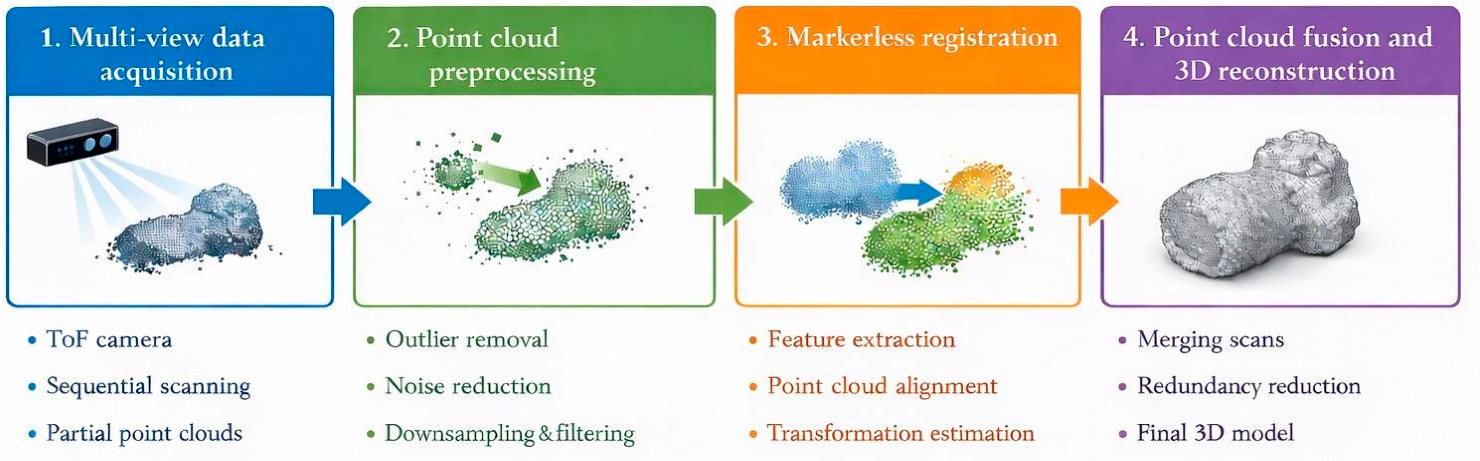
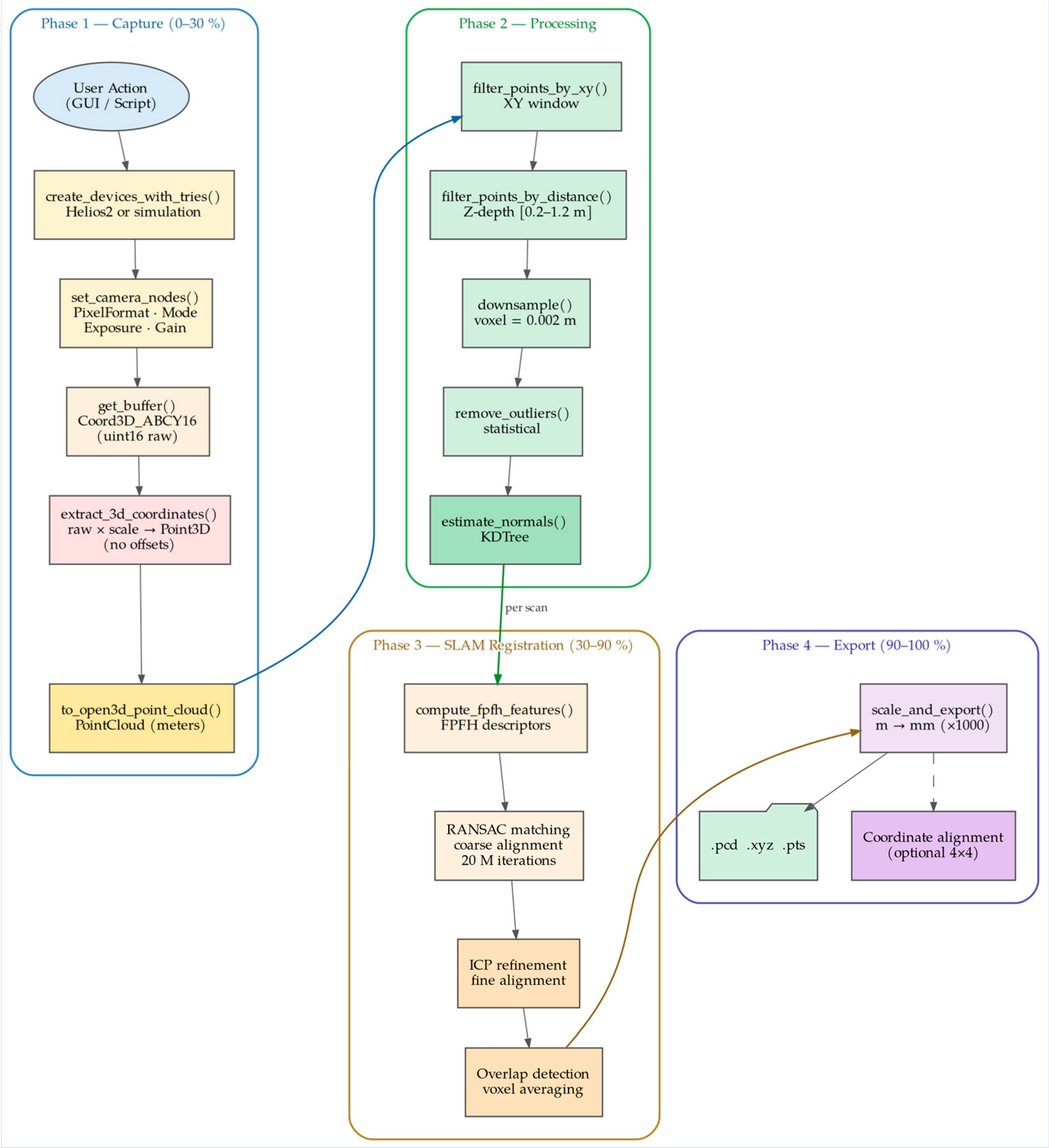
The proposed workflow comprises four main phases. First, partial 3D datasets are acquired from multiple viewpoints. The raw point clouds are then preprocessed to improve their geometric consistency and to reduce measurement artefacts. Subsequently, consecutive scans are automatically registered in a markerless manner. In the final phase, the registered point clouds are fused into a unified 3D model. The overall processing chain is schematically illustrated in
Figure 1. The system architecture is designed to ensure that each phase produces data of sufficient quality for the following stage, which is particularly important in the case of ToF measurements due to their inherent susceptibility to noise, outliers, and incomplete surface coverage. Data processing pipeline is illustrated in
Figure 2.
3.1. Hardware Configuration
The Helios2 time-of-flight 3D camera (sourced from LUCID Vision Labs Inc., Burnaby, BC, Canada) serves as the sensing unit of the proposed system and is used to acquire range data from multiple viewpoints around the scanned object. By directly providing depth information and point cloud output, the sensor enables the capture of 3D surface geometry without the need for stereo-based reconstruction or structured-light pattern decoding. In the developed scanning configuration, the relative position between the sensor and the object is varied to obtain multiple partial views, which are subsequently integrated into a complete or near-complete 3D representation.
The hardware arrangement is based on an object-centred scanning approach in which the sensor position, the object orientation, or a combination of both is altered between individual acquisitions. This configuration allows different object surfaces to be observed while preserving the overlap required between consecutive scans. Such overlap represents a key prerequisite for markerless registration, as it provides the shared geometric content needed to estimate the spatial transformation between point clouds. Accordingly, the acquisition strategy is designed to achieve a compromise between extending surface coverage and maintaining sufficient overlap for reliable registration.
In practical experiments, the physical setup incorporates a rigid sensor mount, a stable placement area for the scanned object, and controlled surrounding conditions in order to limit unwanted sources of variability. Since ToF sensing is affected by surface reflectivity, ambient conditions, and edge artefacts, ensuring repeatable acquisition conditions contributes to greater consistency of the captured point clouds and reduces the risk of unsuccessful registration due to irregular measurement quality.
3.2. Software Architecture and Data Flow
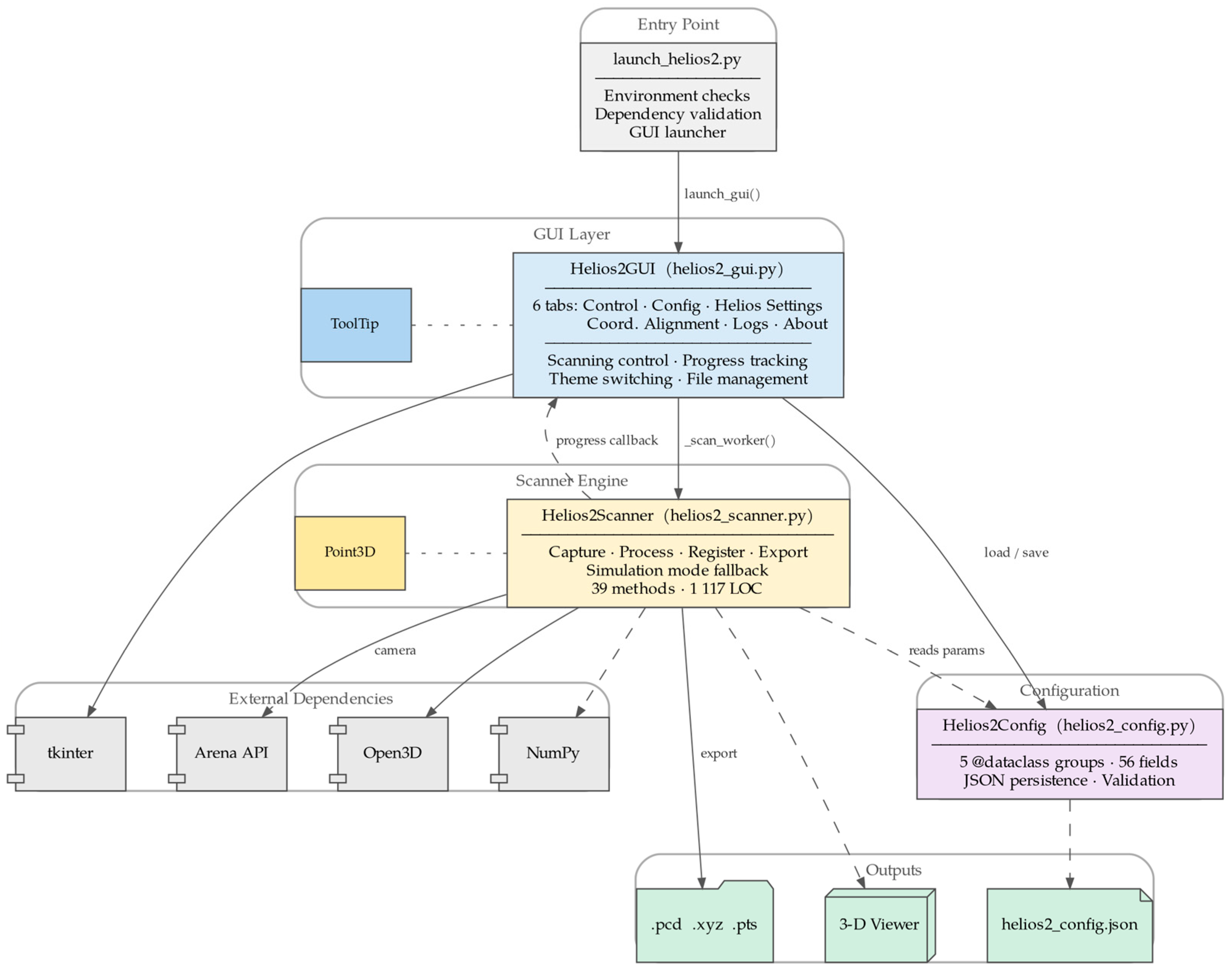
The proposed markerless 3D scanning system is implemented as an integrated software application, as seen in
Figure 3, designed for acquisition, processing, alignment, and export of multi-view point clouds obtained from the Helios2 time-of-flight camera. The software was developed as a complete workflow-oriented platform rather than as a standalone registration script, with the aim of supporting practical object digitization under markerless conditions. Its architecture reflects the need to process raw ToF data reliably while preserving sufficient flexibility for parameter tuning, staged execution, and later extension of the workflow. The system is organized as a sequence of interconnected software layers corresponding to the main phases of the reconstruction process. These layers include data acquisition, raw coordinate conversion, point-cloud preprocessing, automatic alignment, post-registration fusion, visualization, and export. Although these stages operate as a single application workflow, they remain logically separated so that each stage can be configured independently and, when necessary, executed separately. This modular arrangement is particularly important for ToF-based scanning, where the quality of the final reconstruction depends not only on the alignment method, but also on the stability of data acquisition and the conditioning of the measured point clouds before registration. The input to the software consists of raw 3D output from the Helios2 sensor. During acquisition, the system reads the native depth-coordinate representation provided by the camera and converts it into metric three-dimensional point coordinates. This conversion is performed using the camera-specific scaling and offset parameters associated with the measured coordinate channels. The result of this stage is a structured point cloud representing a partial view of the scanned object. Because the correctness of this transformation directly affects all later processing stages, the conversion step forms a critical part of the overall architecture rather than a simple format translation. After conversion into point-cloud form, the acquired scan enters a preprocessing stage intended to improve its suitability for markerless registration. To provide a high-level overview of the internal organization of the developed software platform, the system architecture is illustrated in
Figure 3. The architecture is structured into three main layers: the graphical user interface, the scanning engine, and the configuration subsystem. External dependencies, including Open3D, NumPy, and the Arena SDK, are integrated into the scanning engine layer, while the GUI layer provides user interaction, workflow control, and visualization. The configuration module ensures consistent parameter management, validation, and persistence across the entire workflow.
The processing pipeline is built on functions provided by the Open3D 0.19.0 library and combines several standard point-cloud conditioning operations [
18,
19]. First, the raw point cloud is rescaled into a consistent metric representation suitable for geometric processing. Then voxel-based downsampling is applied to reduce point density while preserving the overall structure of the measured surface. This step decreases computational load and also helps suppress local irregularities that may destabilize correspondence estimation. Next, statistical outlier removal is performed to eliminate isolated points that are unlikely to belong to the true object surface. Since ToF measurements are frequently affected by noise, edge distortions, and unstable returns, this filtering stage plays an important role in improving registration robustness. After geometric cleaning, surface normals are estimated for the remaining points. These normals are required for subsequent registration operations and provide local geometric information used during feature-based matching and pose refinement. Once the point clouds have been preprocessed, they are passed to the automatic alignment stage. In the present system, markerless registration is implemented as a coarse-to-fine rigid alignment process using Open3D registration methods. At the coarse level, local geometric features are computed for the input point clouds and used to establish correspondences between overlapping views. On the basis of these correspondences, an initial rigid transformation is estimated using a RANSAC-based matching procedure. This stage is intended to provide a sufficiently reliable initial pose even when the scans are not yet closely aligned. After this initialization, a refinement step is performed using the Iterative Closest Point (ICP) algorithm, which iteratively minimizes the geometric discrepancy between the overlapping surfaces. In the multi-view workflow, this procedure is applied sequentially to successive scans, resulting in an incrementally aligned set of point clouds within a common coordinate frame. The alignment stage is followed by post-processing and fusion of the registered scans. In the implemented workflow, the aligned point clouds are not merely superimposed and saved directly. Instead, the software applies an additional integration stage in which overlapping data are consolidated and the merged result is regularized. This includes voxel-based averaging of points that fall within common spatial cells and subsequent reduction in redundant samples. The purpose of this step is to reduce duplication and local scatter in overlap regions, thereby producing a cleaner and more coherent reconstructed point cloud. This fused representation forms the final reconstruction output of the system. To support practical scanning scenarios, the software architecture also includes interactive workflow control. The operator may execute the entire sequence as a continuous pipeline, beginning with scan acquisition and ending with export of the fused reconstruction. However, the system also allows staged execution, in which scans are captured first, registration settings are evaluated on temporary datasets, alignment is previewed, and final fusion and export are performed only after verification of satisfactory intermediate results. This capability is particularly useful for markerless scanning of objects with weak geometric features, uncertain overlap conditions, or increased sensitivity to ToF artefacts. In such cases, the possibility of validating intermediate alignment results improves both usability and experimental reliability. The final output of the software may be exported in several standard point-cloud formats suitable for subsequent visualization, measurement, or external processing. The system also supports scaling of the reconstructed geometry into engineering units, which facilitates downstream use in inspection and digital modelling workflows. In addition, visualization of intermediate and final point clouds is supported directly within the processing environment, enabling rapid inspection of capture quality and registration performance.
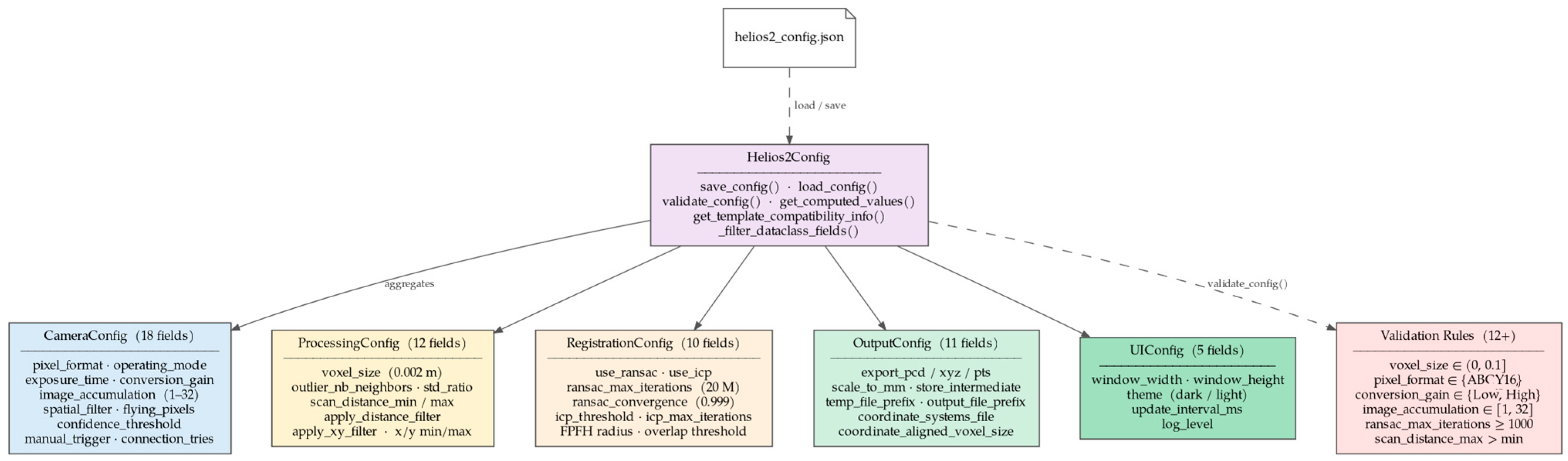
The configuration system is implemented as a structured hierarchy of parameter groups, as shown in
Figure 4. The configuration manager organizes parameters into logical categories, including camera settings, preprocessing parameters, registration configuration, output settings, and user interface options. Each group is defined using data classes and validated through predefined constraints, ensuring consistency and robustness of the scanning workflow.
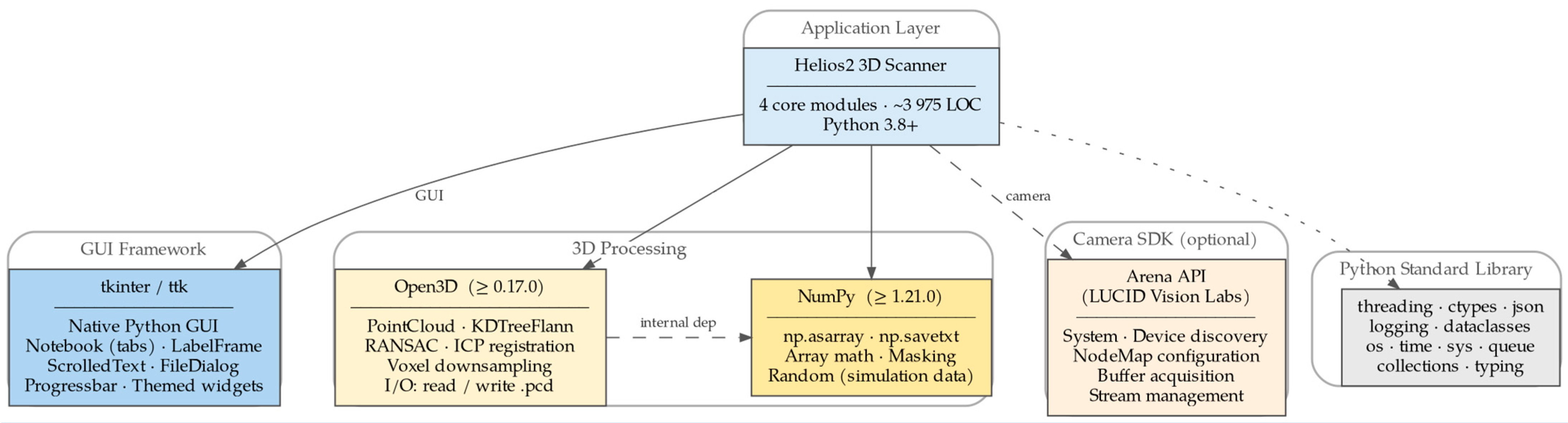
The developed system relies on a combination of standard Python 3.12 libraries and specialized external frameworks for 3D processing and hardware communication. The overall technology stack, including version requirements and functional roles of each component, is summarized in
Figure 5.
3.3. Multi-View Acquisition Strategy
The proposed scanning system uses a multi-view acquisition strategy in which the object is digitized through a sequence of partial point clouds captured from different observation positions. Since a single Helios2 time-of-flight acquisition provides only a limited view of the object surface, multiple scans are required to obtain broader surface coverage and to reduce the influence of occlusion. The acquisition strategy was therefore designed to support gradual reconstruction of object geometry through successive overlapping views while preserving the conditions necessary for reliable markerless alignment. In the developed workflow, acquisition follows an object-centred scan–move–scan principle. After each scan is recorded, the relative position between the sensor and the object is changed before the next acquisition is performed. This change may be introduced by repositioning the camera, rotating the object, or combining both actions, depending on the physical arrangement of the experiment. The key requirement is that neighbouring scans retain sufficient overlap of visible surface geometry. Because the implemented registration method relies on geometric correspondences extracted directly from the point clouds, overlap between consecutive views is essential for successful coarse alignment and subsequent ICP refinement. The acquisition sequence is therefore not defined solely by the goal of maximizing coverage but by the need to balance coverage expansion with preservation of common geometric structure.
The software architecture supports this acquisition strategy in both continuous and staged forms. In a continuous workflow, multiple scans are captured in sequence and then processed automatically as part of a full reconstruction pipeline. In a staged workflow, individual scans are first acquired and stored as temporary point-cloud datasets, after which the operator may inspect the captured views, evaluate whether sufficient overlap has been achieved, and only then proceed to registration and fusion. This staged mode is particularly beneficial in practical markerless scanning, where poor viewpoint spacing or insufficient shared geometry may otherwise lead to unsuccessful alignment. By separating capture from registration, the system makes it possible to verify the adequacy of the acquired scan set before final reconstruction is performed. From a geometric perspective, the acquisition strategy aims to produce a sequence of partial views with moderate viewpoint variation between successive scans. If the viewpoint change is too small, the resulting scans contain excessive redundancy and do not contribute significantly to improved surface coverage. If the viewpoint change is too large, the amount of common visible surface may become insufficient for robust markerless registration. For this reason, the acquisition process was conceived as a gradual progression around the object, where each newly acquired scan extends the observed surface while still preserving enough local similarity with the preceding view to support correspondence estimation. In practice, this means that the scanning trajectory should avoid abrupt viewpoint jumps and should instead follow a smooth sequence of observation angles. The effectiveness of this strategy depends strongly on object geometry. Objects with rich local shape variation, visible edges, and non-repetitive surface structure are generally easier to align because they provide more distinctive geometric information for markerless correspondence matching. By contrast, simple, smooth, or highly symmetric objects are more difficult to scan reliably using a markerless approach, because neighbouring views may contain fewer unique features that would constrain the estimated transformation. The acquisition strategy therefore has to be adapted to the type of object being digitized. For simple objects, smaller incremental viewpoint changes and more carefully controlled overlap are required. For more geometrically complex objects, the system can typically tolerate larger changes between views while still maintaining registration stability.
The strategy also takes into account practical properties of ToF sensing. Helios2 point clouds may contain edge artefacts, isolated noise points, and local depth instability caused by surface reflectivity or measurement geometry. These effects can reduce the effective amount of usable overlap between scans even when the nominal viewpoint change appears acceptable. Accordingly, the acquisition procedure is intended to be performed under stable environmental and geometric conditions, with the object placed in a repeatable measurement scene and the sensor mounted in a manner that minimizes unintended motion or vibration. Controlled acquisition conditions improve consistency between scans and reduce the likelihood that registration will fail because of variations unrelated to object geometry itself. In the context of the developed software, multi-view acquisition is not treated as a separate preliminary activity but as an integral part of the full reconstruction workflow. The order of captured scans determines the sequence in which pairwise markerless registration is performed, and therefore directly influences the quality of the accumulated alignment. Because the current implementation uses sequential coarse-to-fine registration of neighbouring scans, acquisition order should reflect a physically meaningful path around the object, such that each scan is most similar to the one acquired immediately before it. This makes the acquisition sequence itself part of the registration strategy, rather than merely a data collection procedure. Scanning sequence with multi-view acquisition strategy can be seen in
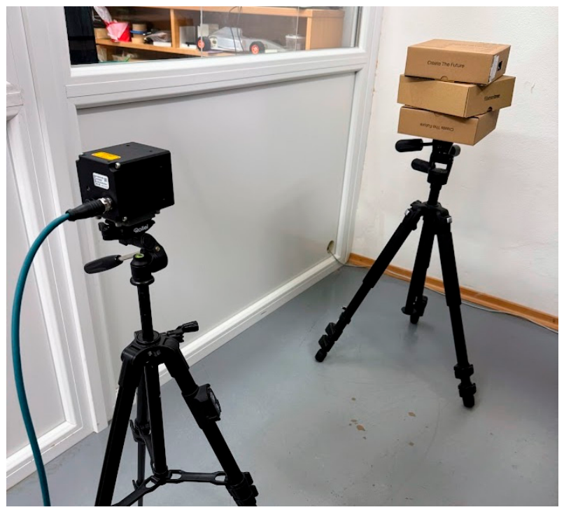
Figure 6. Helios2 was placed at a distance of 1 m from scanned objects.
3.4. Point Cloud Preprocessing Module
In addition to viewpoint planning, the acquisition procedure required adjustment of several Helios2 camera parameters in ArenaSDK v1.0.65.17. The operating distance mode was selected according to the expected object distance and measurement volume, while the exposure time was set manually using one of the camera’s available integration settings (62.5 μs, 250 μs, or 1000 μs). To improve the quality of the acquired point clouds for markerless registration, the confidence threshold was adjusted to suppress unreliable depth measurements, and the flying-pixel filter was used to reduce edge artefacts and mixed-depth pixels that commonly occur in time-of-flight sensing. These parameter settings were important for improving the stability of the acquired partial scans and increasing the amount of usable geometric information for subsequent registration and fusion. Parameters for digitization were chosen based on previous research [
20,
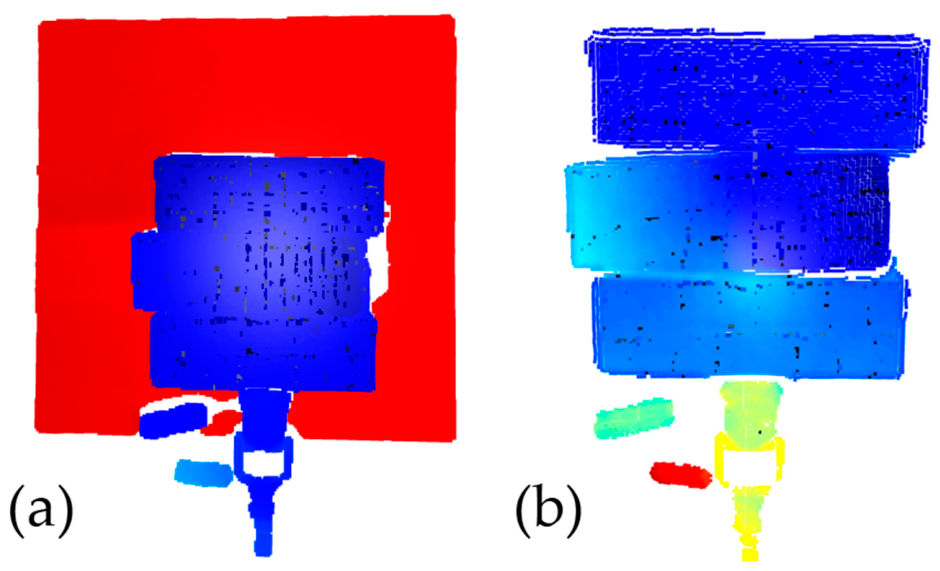
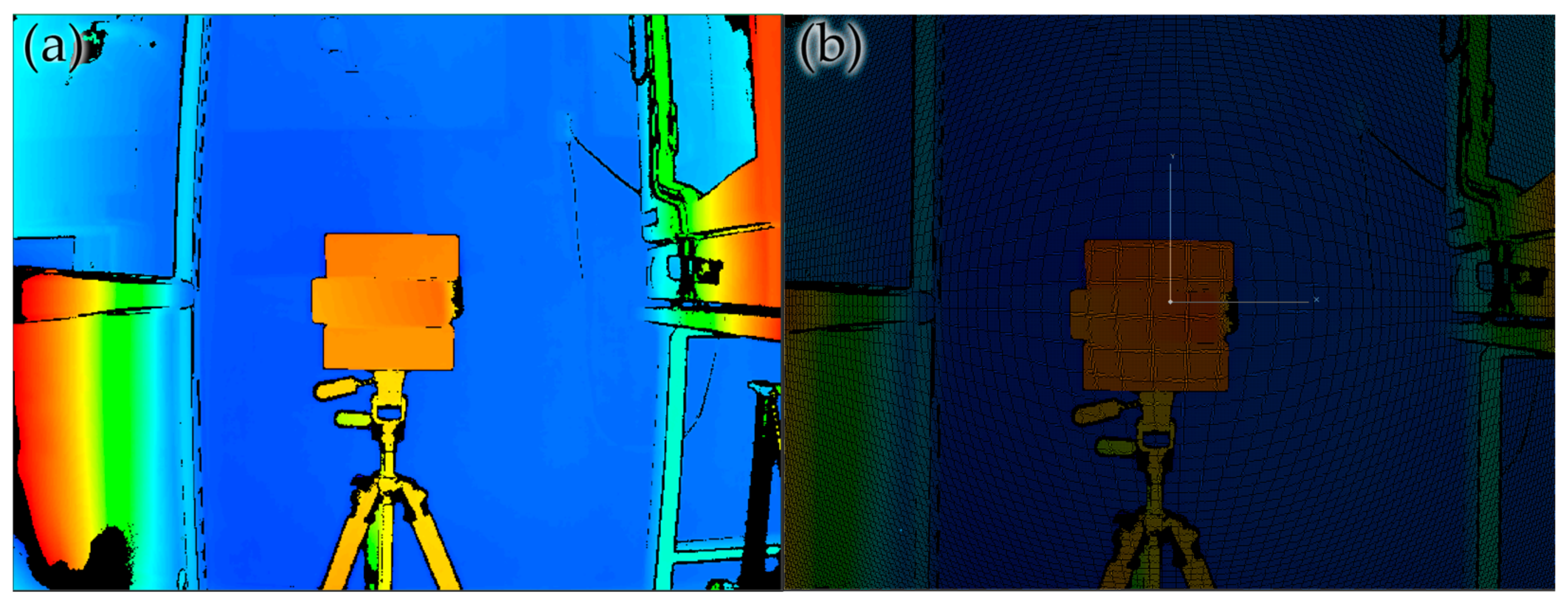
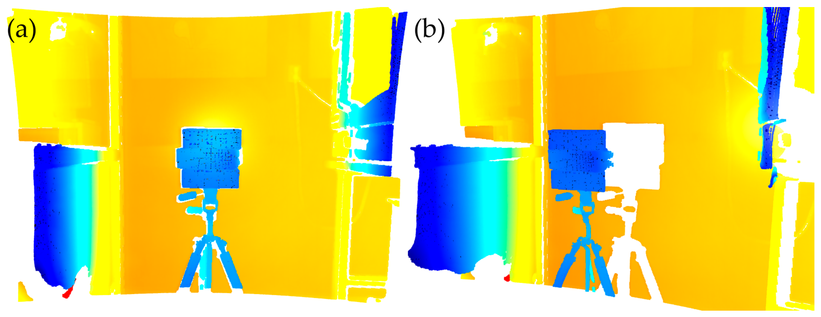
21]. Acquired depth map from one scanning sequence can be seen in
Figure 7a, and the acquired point cloud is in
Figure 7b.
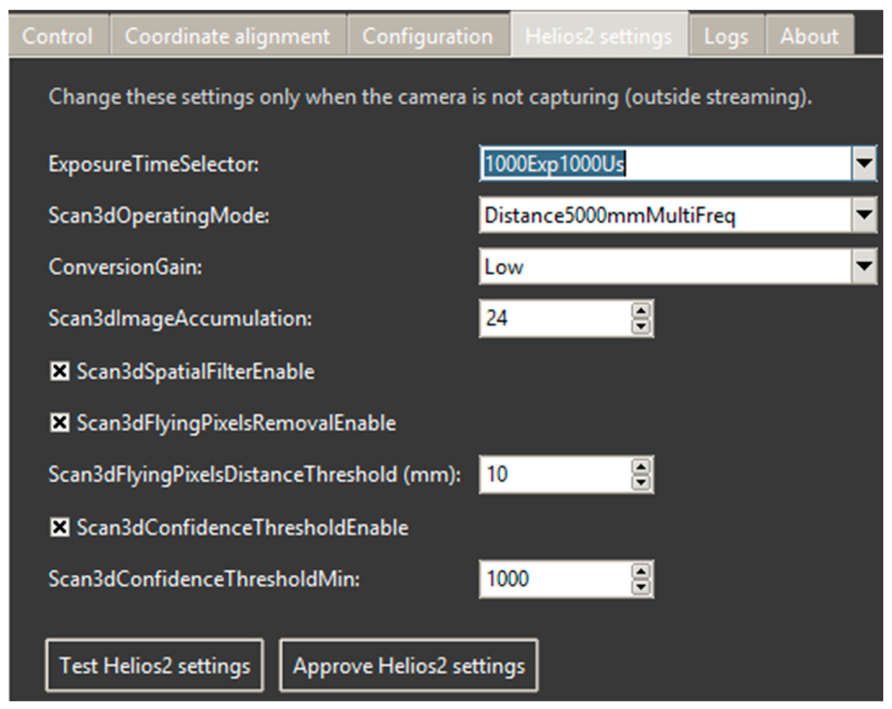
To improve the quality and repeatability of the acquired Helios2 point clouds, the camera was configured with sensor parameters selected specifically for static Time-of-Flight scanning. The ExposureTimeSelector was set to 1000Exp1000Us to maximize depth output stability under the fixed experimental setup. The Scan3dOperatingMode was set to Distance5000mmMultiFreq, which provided the most favorable Accuracy and Precision values for the working distance used in this study according to the manufacturer documentation and preliminary acquisition tests [
11]. ConversionGain was kept at Low because higher gain settings increased surface deformation in planar side regions of the scanned objects.
To further improve the robustness of the acquired data, Scan3dImageAccumulation was set to 24, enabling temporal averaging of repeated measurements and reducing random depth fluctuations in the static scene. Scan3dSpatialFilterEnable was activated to suppress local spatial defects, while Scan3dFlyingPixelsRemovalEnable was enabled to remove isolated pixels and mixed-depth artifacts that are typical of ToF sensing near depth discontinuities. The Scan3dFlyingPixelsDistanceTreshold was set to 10 mm as a conservative rejection threshold for inconsistent measurements. Helios2 Accuracy is ±4 mm and Precision 0.6 mm up to distance 1.25 m based on documentation, so with small reserve no correct points should be behind 10 mm limit from actual surface. In addition, Scan3dConfidenceTresholdEnable was enabled and Scan3dConfidenceTresholdMin was set to 1000, which excluded low-confidence regions while preserving enough surface coverage for subsequent registration. Chosen Helios2 parameters, as seen in
Figure 8, exhibited highest quality 3D point cloud for subsequent processing.
As can be seen in
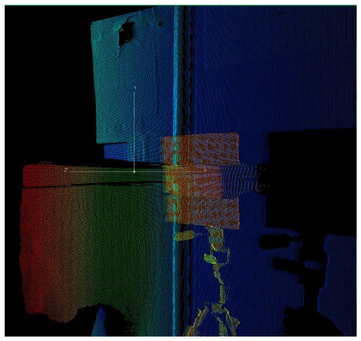
Figure 9, acquired single point cloud from single Helios2 scan only acquires surface from viewpoint, which does not include side view of scanned objects. This confirms the necessity for multi-view approach to digitize physical objects using Helios2 Time-of-Flight 3D camera.
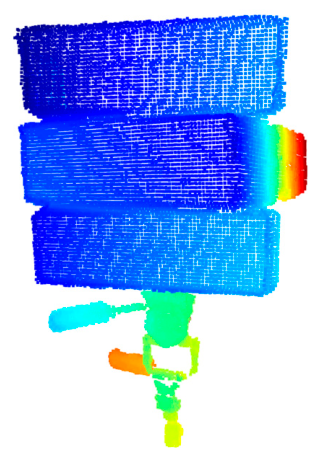
The point cloud preprocessing module is a critical component of the proposed scanning system because raw Helios2 time-of-flight measurements are not immediately suitable for robust markerless registration. The directly acquired point clouds may contain isolated outliers, irregular point density, local surface instability, and artefacts near object boundaries. If such effects are not reduced before alignment, they can degrade correspondence estimation, increase the probability of incorrect transformation hypotheses, and reduce the stability of fine registration. For this reason, preprocessing is implemented as an explicit intermediate stage between scan acquisition and automatic alignment. Acquired point cloud from single scan used for preprocessing can be seen in
Figure 10a, with a side view in
Figure 10b.
The first role of the preprocessing module is to convert the captured data into a geometrically consistent representation suitable for further point-cloud operations. After extraction of the three-dimensional coordinates from the native sensor output, the point cloud is expressed in a metric coordinate system and prepared for subsequent filtering and registration procedures. This step ensures that all scans enter the processing chain in a uniform format and scale, which is essential for consistent thresholding, neighborhood analysis, and transformation estimation in later stages. Concurrently, it was necessary to define the area of interest for the 3D scanning process. The raw point cloud contained an area that was not relevant to the 3D scanning process. It is hypothesised that this area may be conducive to a deterioration in alignment quality. The initial step entailed identifying the region of interest for the 3D scanning process, wherein the x
min and x
max values were selected along the X-axis, and the y
min and y
max values were designated along the Y axis, with outliers being removed. The definition of the region of interest for 3D scanning along the X and Y axes is illustrated in
Figure 11a. Subsequently, a definition was determined for the region of interest for 3D scanning along the Z axis, with values z
min and z
max that were selected in a similar manner. Point cloud after determining region of interest in XYZ can be seen in
Figure 11b.
Once the point cloud has been converted into a usable spatial representation, the software applies voxel-based downsampling using Open3D 0.19.0, specifically through open3d.geometry.PointCloud.voxel_down_sample(voxel_size). Voxel size was chosen of 1.5 mm. This value is small enough to preserve the planar faces, edges, and local surface transitions of the scanned objects, but still large enough to regularize the dense raw Helios2 output and suppress point-to-point jitter. A smaller voxel would preserve more noise and increase computation, while a much larger voxel would remove useful local detail and weaken the geometric descriptors used by FPFH. In practice, 1.5 mm is a reasonable compromise for ToF data with 0.6 mm precision at 1 m distance when the goal is reliable alignment rather than ultra-fine metrology. This operation divides the point cloud into spatial cells of predefined size and replaces the original dense local sampling by a reduced set of representative points. The purpose of voxel downsampling is twofold. First, it decreases computational load during feature extraction and registration, which is particularly important when processing multiple scans in sequence. Second, it regularizes local sampling density, reducing the influence of highly nonuniform point distributions that may otherwise bias correspondence estimation. In practical terms, voxelization acts as an initial simplification step that preserves the global geometry of the scanned object while suppressing unnecessary local redundancy.
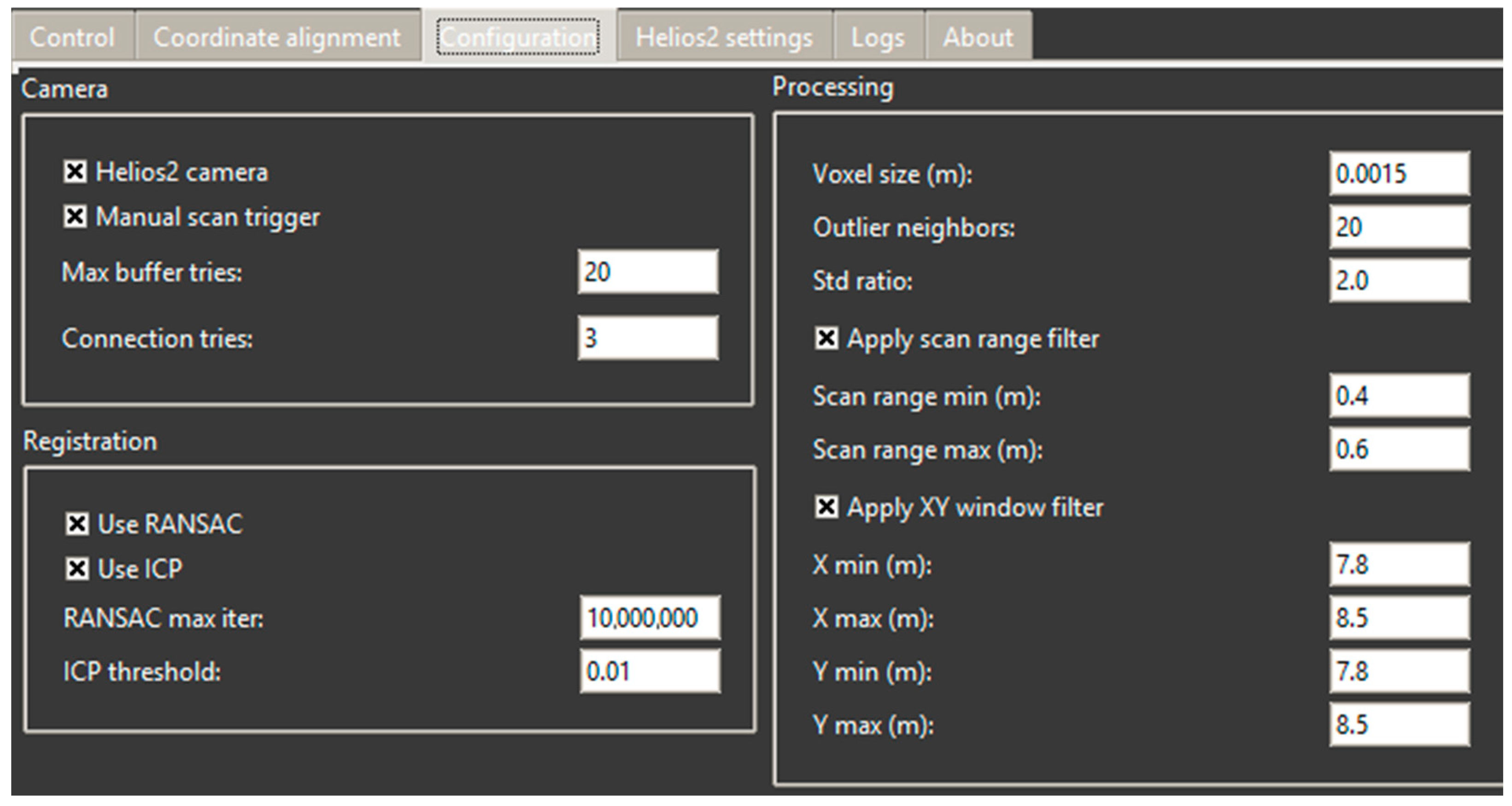
After density reduction, the preprocessing stage applies statistical filtering to remove points that are unlikely to belong to the true object surface. In ToF measurements, such points may arise from unstable returns, multipath effects, edge distortions, or noise in poorly measured regions. In Open3D 0.19.0, this can be done with open3d.geometry.PointCloud.remove_statistical_outlier(nb_neighbors, std_ratio). Statistical outlier removal evaluates the spatial neighbourhood of each point and rejects points whose local distance distribution deviates significantly from that of the surrounding cloud. By eliminating isolated or weakly supported samples, this step improves the structural coherence of the data and reduces the risk that noise points will interfere with geometric matching during the alignment stage. Using 20 neighbors gives the statistical filter enough local context to distinguish true surface structure from isolated noisy samples. For Helios2 data, this matters because ToF measurements often contain small clusters of unstable points near edges, low-confidence regions, or mixed-depth pixels. A very small neighborhood would make the filter too sensitive to local fluctuation, while a very large one could blur genuine geometric boundaries and remove valid points. A standard-deviation ratio of 2.0 is a moderate and defensible filtering strength. It removes points that clearly deviate from the local neighborhood distribution but does not aggressively erase valid surface points. That balance is important for ToF data because the point cloud already contains missing areas and lower-resolution zones. Overly strict filtering would make the cloud too sparse for robust correspondence estimation. With ToF, the aim is to remove outliers without destroying the geometry needed for FPFH and ICP. Configuration parameters for further processing of ToF data for alignment and registration can be seen in
Figure 12.
Following downsampling and outlier suppression, the preprocessing module estimates surface normals for the filtered point cloud. In Open3D 0.19.0, this is performed with open3d.geometry.PointCloud.estimate_normals(search_param). Normal estimation is important because the subsequent registration pipeline uses geometric information derived from local neighbourhood structure rather than relying solely on point coordinates. In a markerless registration workflow, surface normals improve the description of local shape and contribute to the stability of feature-based matching and refinement. Their calculation therefore forms a preparatory step for the coarse-to-fine alignment procedure used later in the pipeline. At the same time, the quality of the estimated normals depends strongly on the outcome of the earlier filtering operations, which further underlines the importance of preprocessing as a structured sequence rather than a collection of independent tasks.
In the implemented system, preprocessing is designed not merely as a cleaning step, but as a conditioning stage that prepares the input data for robust pairwise and multi-view registration. This distinction is important. The objective is not only to improve the visual appearance of individual point clouds, but also to enhance the reliability of geometric relations between successive scans. A well-conditioned point cloud should preserve the structural features necessary for correspondence matching while reducing those measurement artefacts that could mislead transformation estimation. Accordingly, the preprocessing module seeks a balance between simplification and preservation of usable geometric content.
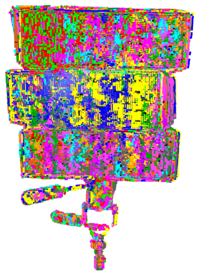
The parameters governing downsampling density, filtering strength, and related operations are configurable within the software architecture. This allows the preprocessing behavior to be adapted to different object sizes, surface conditions, and expected scan quality. Such configurability is particularly relevant for Helios2-based scanning because the optimal compromise between point density, noise suppression, and feature preservation may vary depending on the geometry and reflectivity of the measured object. By exposing these parameters as adjustable workflow settings, the system supports both repeatable experimental evaluation and flexible practical deployment. As part of the multi-view 3D scanning sequence, 12 individual 3D scans were captured, which were not aligned by default. The resulting consecutive 3D scans are shown in
Figure 13.
3.5. Automatic Alignment Module
The automatic alignment module represents the central stage of the proposed markerless 3D scanning system, because it estimates the rigid spatial transformations required to bring multiple partial Helios2 scans into a common coordinate system without the use of artificial markers or manually selected correspondences. In the developed workflow, alignment is based entirely on geometric information contained in the preprocessed point clouds. This approach is consistent with the intended application of the system in practical digitization tasks where placement of reference targets would reduce flexibility and increase preparation time.
The implemented registration procedure follows a coarse-to-fine strategy based on functions available in Open3D version 0.19.0. After preprocessing, local geometric descriptors are computed for each point cloud using the function open3d.pipelines.registration.compute_fpfh_feature(). These Fast Point Feature Histograms (FPFHs) provide a local description of point neighbourhood geometry and are used to establish candidate correspondences between overlapping scans. Because the raw Helios2 point clouds are affected by noise and moderate resolution limitations, the use of local descriptors is important for obtaining an initial alignment that is not dependent on exact point-to-point proximity from the outset.
On the basis of the computed FPFH descriptors, the system performs coarse registration using the Open3D function open3d.pipelines.registration.registration_ransac_based_on_feature_matching(). This function estimates an initial rigid transformation by searching for a geometrically consistent set of correspondences between the source and target point clouds. In the implemented workflow, the procedure is configured to use point-to-point transformation estimation through open3d.pipelines.registration.TransformationEstimationPointToPoint(False), while correspondence consistency is constrained using open3d.pipelines.registration.CorrespondenceCheckerBasedOnEdgeLength(0.9) and open3d.pipelines.registration.CorrespondenceCheckerBasedOnDistance(distance_threshold). The iterative search termination is controlled by open3d.pipelines.registration.RANSACConvergenceCriteria(…). This RANSAC-based stage is responsible for finding an approximate global pose even when the relative position of the point clouds is initially unknown and the overlap is only partial. RANSAC max iter was chosen 10,000,000. A high iteration cap is justified because coarse global alignment on noisy ToF clouds is probabilistic: the more noise, fewer distinctive features, and lower overlap between views, the higher the chance that many RANSAC hypotheses are rejected before a valid correspondence set is found. Increasing the iteration limit improves the probability of reaching a geometrically consistent solution, especially when the object has limited texture or repeating planar regions. In a staged reconstruction workflow, runtime is less critical than avoiding failed registration, so a high iteration budget is acceptable. Increasing max value is not forcing that value, just increasing higher limit. RANSAC iterations are close to 1,000,000 in general.
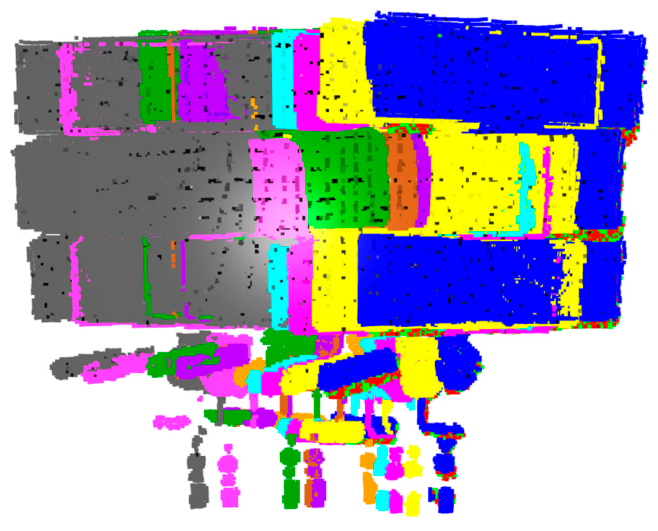
Once a plausible coarse transformation has been determined, the alignment is refined using the Iterative Closest Point method. In the present software, ICP refinement is applied after the RANSAC initialization in order to reduce residual local misalignment between overlapping surfaces. An ICP threshold of 10 mm was chosen. A 10 mm ICP correspondence threshold is a practical refinement distance for Helios2 data after coarse alignment. It is wide enough to absorb residual misalignment and ToF depth uncertainty but still tight enough to prevent ICP from drifting toward incorrect correspondences across unrelated surfaces. Because ICP is used only after preprocessing and RANSAC initialization, the threshold does not need to be overly large; instead, it should reflect the remaining uncertainty after coarse registration. For static scans with moderate resolution, 10 mm is a reasonable refinement bound considering previously chosen Helios2 Scan3dFlyingPixelsDistanceTreshold of 10 mm. Although the implementation logic treats this as a separate refinement step within the registration pipeline, its practical purpose is to iteratively minimize geometric discrepancies after the approximate transformation has already been established. This coarse-to-fine approach is particularly appropriate for ToF-based point clouds, where direct fine registration without reliable initialization would be vulnerable to convergence toward incorrect local minima. Global RANSAC and ICP aligned and overlapped scans can be seen in
Figure 14.
The multi-view reconstruction workflow applies this registration procedure sequentially to successive scans. In other words, each newly acquired point cloud is aligned to the previously aligned point cloud in the acquisition sequence, and the resulting transformed scan is added to the growing set of registered views. This strategy makes the registration process compatible with the scan–move–scan acquisition concept adopted in the system. At the same time, it places practical importance on preserving sufficient geometric overlap between neighbouring scans, since the success of each registration step depends on the availability of shared surface structure between consecutive views.
The alignment module was designed with the understanding that registration quality depends not only on the mathematical optimization process itself but also on the quality of the input clouds delivered by the preprocessing stage. If outliers, edge artefacts, or unstable point density remain too prominent, the FPFH descriptors may become less distinctive and the RANSAC stage may generate incorrect hypotheses or unstable correspondences. Similarly, if the coarse alignment is poor due to insufficient overlap or ambiguous object geometry, ICP refinement may converge to an incorrect local solution. For this reason, the automatic alignment module is treated as part of a broader system-level workflow in which acquisition planning, preprocessing quality, and registration robustness are tightly interconnected.
3.6. Point Cloud Fusion and Reconstruction Output
Once the individual scans have been aligned into a common coordinate system, the next stage of the workflow is their integration into a single reconstructed representation of the scanned object. In the proposed system, this phase is not treated as a simple accumulation of transformed point clouds, but as an additional processing stage intended to reduce redundancy, improve geometric consistency, and prepare the final reconstruction for export and practical use. The quality of the output generated in this stage depends directly on the stability of the preceding alignment process, since even small residual registration errors may propagate into the merged result as local blur, doubled edges, or scattered surface regions.
In the implemented workflow, the registered scans are first combined into a shared geometric dataset representing the accumulated object surface observed from multiple viewpoints. Because neighbouring views contain overlapping regions, direct superposition of all aligned points would typically produce redundant samples and locally increased point density in areas observed repeatedly during acquisition. To address this, the system applies a post-registration consolidation procedure that regularizes the merged cloud after alignment. This stage is intended to reduce duplication in overlap zones and to form a more coherent final representation of the measured geometry.
A key part of this consolidation step is voxel-based spatial integration using open3d.geometry.PointCloud.voxel_down_sample(voxel_size). After the aligned point clouds have been merged, the reconstructed point set is partitioned into three-dimensional voxel cells, and points falling within the same local cell are averaged to produce a representative output sample. This averaging process reduces local scatter and suppresses repeated measurements of the same surface region originating from multiple overlapping scans. In practical terms, it serves as a geometric regularization mechanism that transforms the raw merged dataset into a more compact and visually consistent reconstruction. Since the final cloud is derived from several registered observations rather than from a single acquisition, this step is important for obtaining a stable output suitable for further evaluation and export.
Following voxel-based averaging, the integrated point cloud is further reduced through downsampling so that the final representation remains computationally manageable and structurally uniform. This step also contributes to improved clarity of the reconstruction by removing unnecessary local redundancy that may persist even after averaging. The result is a fused point cloud that preserves the combined surface coverage of the multi-view acquisition while exhibiting a more regular point distribution than the direct union of all aligned scans.
The final reconstruction generated by this stage, as seen in
Figure 15, may be exported in several standard point-cloud formats. The reconstructed point cloud is saved as .pcd, .xyz, or .pts, depending on the intended downstream use. In addition, the system supports optional scaling of the output coordinates into millimetres, which is particularly useful in engineering workflows where metric inspection or further CAD-related processing is required. This export flexibility allows the reconstructed geometry to be transferred to external visualization, metrology, or modelling environments without the need for additional conversion.
4. Results
The experimental evaluation of the proposed markerless 3D scanning system was carried out with emphasis on a practical robotic application scenario. Rather than testing the system on a broad set of unrelated objects, the evaluation was focused on a specific object category relevant to automated handling and pose estimation. For this reason, the experiments were performed on cardboard boxes used as packaging for 3D printing filament. These objects represent a realistic target class for robotic perception systems operating in storage, logistics, and automated manipulation environments, where boxed items frequently need to be detected, localized, and grasped without the aid of artificial markers.
The main objective of the experimental work was to verify whether the proposed Helios2-based workflow can produce geometrically usable multi-view reconstructions of such objects in a markerless manner. In addition to demonstrating successful reconstruction, the evaluation was intended to determine how closely the resulting 3D geometry corresponds to data obtained from a commercially available markerless scanning device. For this purpose, the same objects were scanned both with the developed system and with the Revopoint Miraco scanner (Revopoint 3D Technologies Inc., Shenzhen, China), and the resulting datasets were compared after polygonization in GOM INSPECT 2018. In this comparison, the Revopoint Miraco reconstructions were used as nominal reference data.
4.1. Test Objects and Application Scenario
The experimental validation was performed using three cardboard boxes originally intended as packaging for 3D printing filament. These objects were selected deliberately in order to simulate a realistic use case for robotic scanning and object localization. In many practical robotic systems, packaged objects of this type must be recognized, spatially localized, and picked from storage areas, shelves, bins, or transport surfaces. In such scenarios, the role of a 3D scanning system is not limited to visualization but extends to providing geometric information usable for object pose estimation and for subsequent manipulation planning.
The selected boxes form a simple but relevant class of industrial objects. Their geometry is dominated by planar faces, straight edges, and repeated orthogonal transitions between surfaces. At first sight, such objects may appear easy to scan because their shape is regular and their surfaces are largely continuous. From the perspective of markerless registration, however, they constitute a nontrivial test case. Compared with geometrically rich freeform objects, cardboard boxes provide relatively few distinctive local features. Their repeated planar regions and edge symmetries may reduce the uniqueness of geometric correspondences between neighbouring scans, which can complicate the estimation of reliable transformations in a markerless multi-view workflow. For this reason, successful reconstruction of such objects is relevant not only from an application standpoint, but also as an indicator of the practical robustness of the proposed scanning strategy.
Another reason for selecting filament boxes lies in their direct relationship to potential robotic use. The intended application is not high-precision metrology of complex freeform surfaces, but rather practical 3D perception of manipulable packaged items. In this context, it is more meaningful to evaluate the system on objects resembling real handling targets than on purely abstract calibration shapes. The chosen boxes therefore provide a suitable compromise between simplicity, practical relevance, and moderate geometric ambiguity. They allow the proposed system to be tested under conditions representative of robotic picking and pose-related scene interpretation, while still being sufficiently structured for comparison with a commercial markerless scanner.
All three test objects were scanned using the developed Helios2-based markerless workflow and subsequently scanned again using the Revopoint Miraco device. This ensured that the comparison was performed on identical physical objects and that the measured deviations reflected differences between the two scanning approaches rather than differences in specimen geometry. The resulting datasets were then prepared for geometric comparison as described in the following subsection.
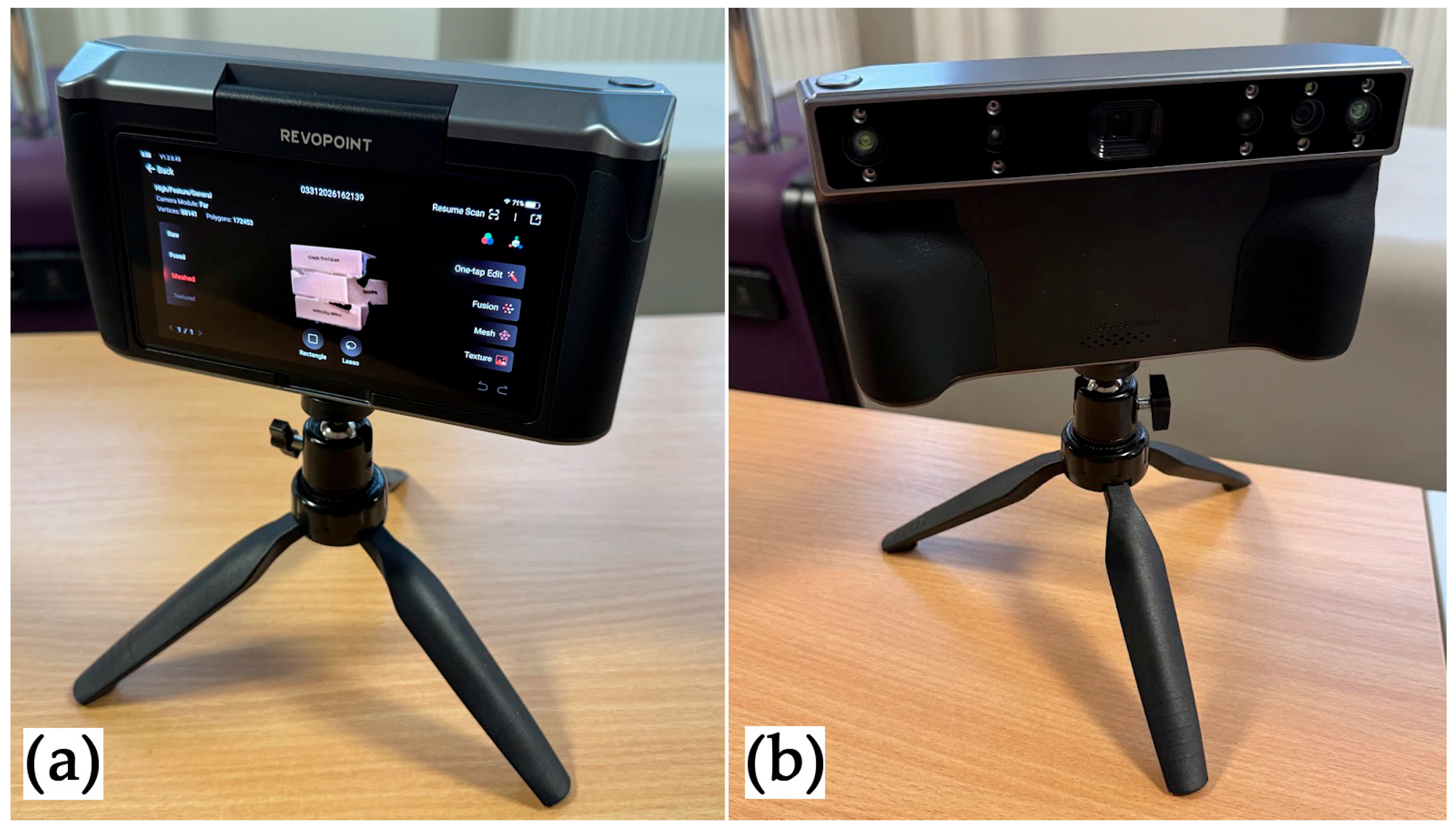
Because the output of the two scanning approaches was not directly comparable in raw acquisition form, both datasets were further processed into polygonal surface models using GOM INSPECT. Polygonization was performed separately for the Helios2-based reconstructed data and for the Revopoint Miraco scan data. This step provided a unified basis for geometric comparison, since surface deviation analysis in GOM INSPECT is more robust and interpretable when both datasets are represented as polygonal models rather than only as unstructured point clouds. In this way, the comparison was based on reconstructed surfaces derived from both technologies under the same evaluation environment. Revopoint Miraco can be seen in
Figure 16.
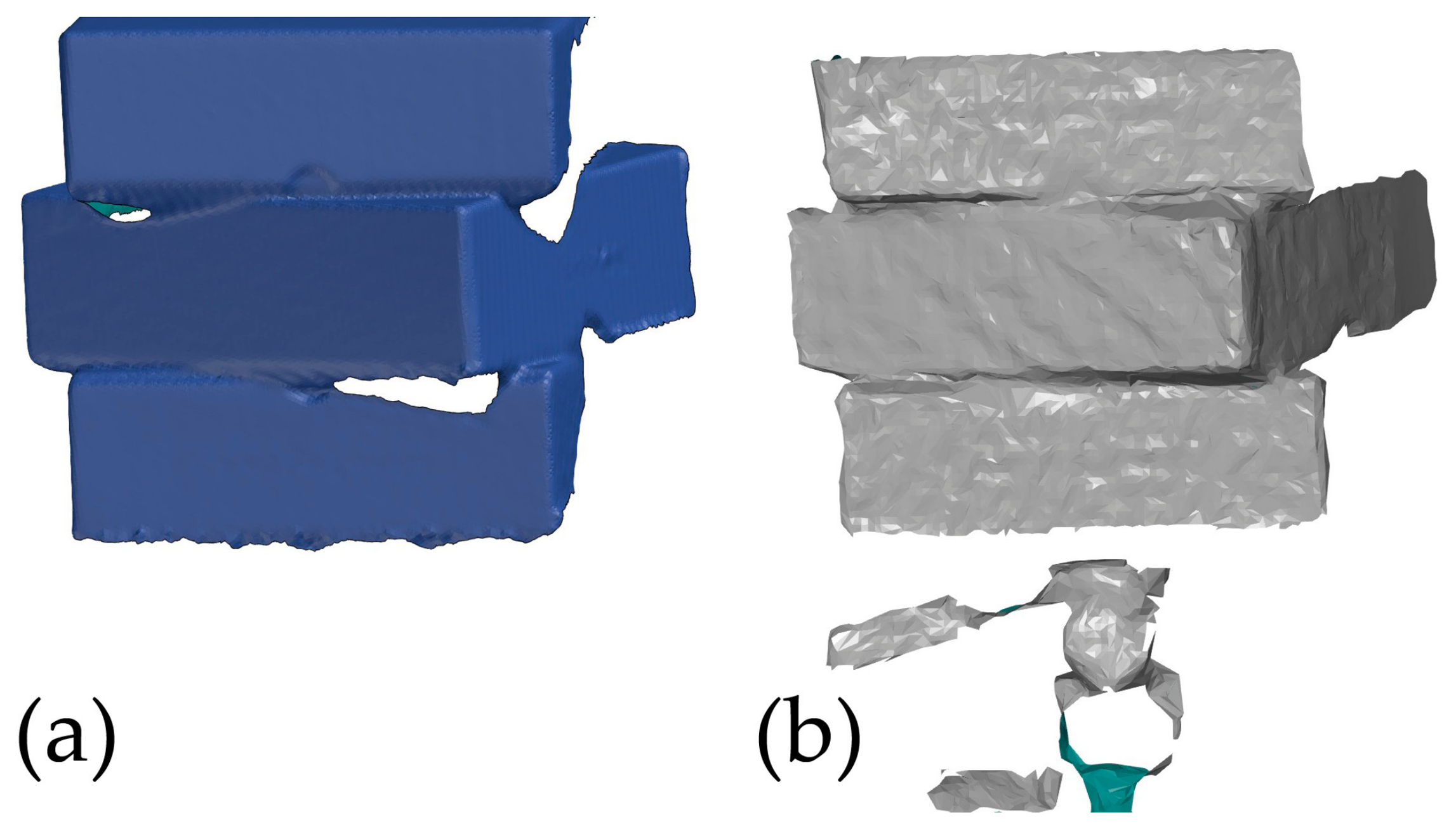
After polygonization, the Revopoint Miraco model of each box was treated as the nominal surface, as seen in
Figure 17a, while the corresponding model generated by the proposed Helios2-based system, as seen in
Figure 17b, was treated as the measured surface. After polygonization of acquired point cloud, surface comparison was then performed in GOM Inspect using standard 3D deviation analysis tools. This procedure made it possible to quantify the geometric differences between the two reconstructed models over the observed object surfaces. The resulting deviation field was used to determine summary statistical indicators describing the agreement between the developed system and the nominal reference data.
In the present study, the principal evaluation measures were the mean deviation and the standard deviation of the measured surface differences. The mean deviation was used as an indicator of overall agreement between the Helios2-based reconstruction and the nominal Miraco model, while the standard deviation sigma was used to express the spread of local geometric deviations over the compared surface. Together, these values provide a compact description of both trueness-like agreement and reconstruction consistency relative to the chosen nominal dataset. Within the context of this evaluation, they serve as practical indicators of how closely the developed markerless scanning workflow approaches the geometry captured by a commercially available markerless scanner.
4.2. Geometric Comparison Results
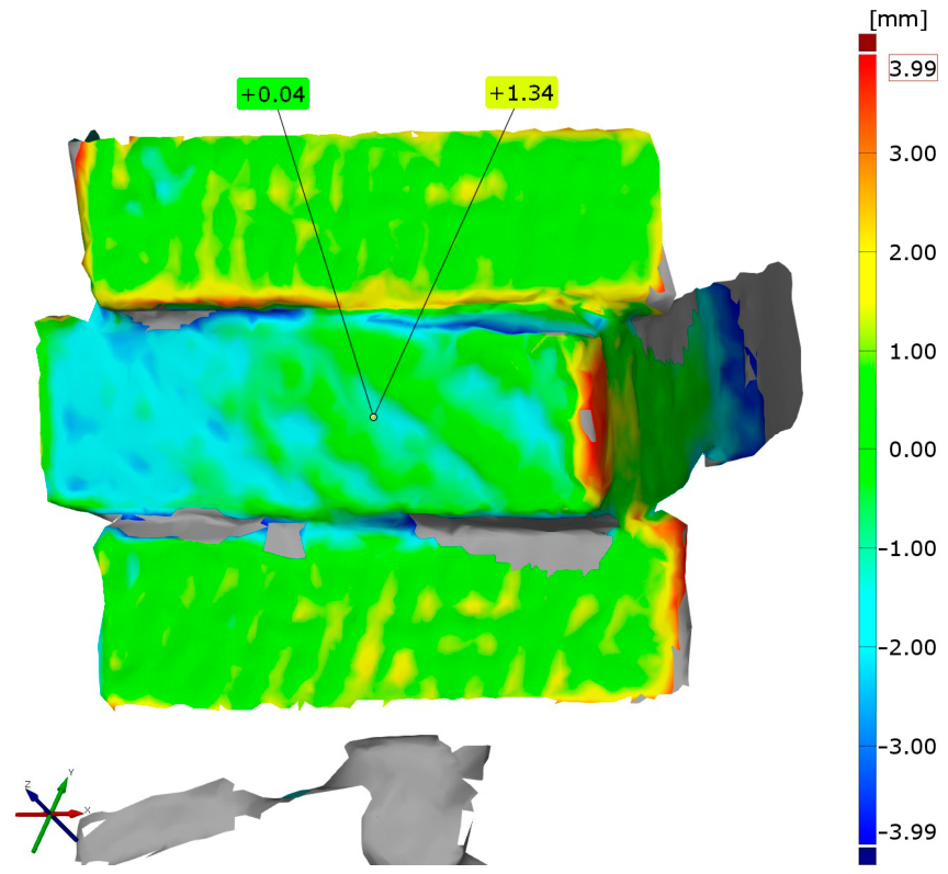
The geometric comparison between the reconstructed models produced by the proposed Helios2-based scanning system and the nominal model obtained from the Revopoint Miraco scanner, as seen in
Figure 18, showed that the developed markerless workflow was capable of reconstructing the tested cardboard boxes with a consistent level of agreement relative to the commercial reference data. For the evaluated set of three filament-box objects, the overall mean surface deviation was 0.04 mm, while the corresponding standard deviation of deviations, expressed as sigma, was 1.34 mm.
The mean deviation indicates that the reconstructed geometry obtained from the proposed system remained, on average, within 0.04 mm of the nominal polygonal surfaces generated from the Revopoint Miraco scans. The standard deviation sigma of 1.34 mm further shows the spread of local surface differences around this mean value and can be interpreted as a measure of reconstruction consistency across the compared object surfaces. Taken together, these values indicate that the developed Helios2-based system is able to generate markerless multi-view reconstructions of the tested packaging objects with a deviation magnitude in the order of 0.04 mm relative to a commercially available markerless scanning technology.
From the viewpoint of the intended application, these results are significant because the tested objects represent box-shaped packages relevant to robotic handling, object localization, and pose estimation. In such use cases, the key requirement is not necessarily the highest achievable metrological precision, but rather a sufficiently faithful representation of the object geometry to support reliable scene interpretation and interaction planning. The obtained deviation levels therefore suggest that the proposed workflow can provide practically meaningful 3D information for these tasks, especially in scenarios where moderate geometric accuracy is acceptable in exchange for a simpler and more accessible ToF-based acquisition system.
At the same time, the achieved results should be interpreted in relation to the specific character of the test objects. The scanned filament boxes are geometrically simple, dominated by planar surfaces and straight edges, and therefore differ from strongly curved or highly detailed freeform objects. Such geometry may influence both the stability of markerless alignment and the nature of local comparison deviations. In particular, broad planar faces may support relatively stable global reconstruction, while edge regions and corners may remain more sensitive to local misalignment, point-cloud sparsity, and polygonization effects. The reported values therefore characterize the agreement of the two scanning approaches for this specific object class rather than for arbitrary shapes in general.
An additional factor affecting interpretation is the comparative nature of the evaluation. Because the Revopoint Miraco data were used as nominal reference geometry, the reported deviation values describe the agreement of the proposed system with a commercial markerless scanner rather than its absolute dimensional error relative to a certified standard. Even so, the results provide a meaningful practical benchmark. They show that the developed Helios2-based workflow is not limited to qualitative visualization but is capable of producing reconstructed geometry that is quantitatively comparable to that obtained from an existing commercial markerless scanning device.
5. Discussion
The presented work addressed the design and evaluation of a markerless multi-view 3D scanning system based on Helios2 time-of-flight data, with particular emphasis on the automatic alignment and integration of successive scans. From a methodological perspective, the proposed solution combines several established point-cloud processing principles into a coherent application-specific workflow: raw coordinate extraction from native ToF output, preprocessing of noisy point clouds, coarse feature-based registration, fine ICP refinement, and voxel-based fusion of aligned views. The contribution of the work therefore lies less in the invention of a fundamentally new registration algorithm and more in the creation and validation of a complete practical scanning system adapted to the limitations and opportunities of Helios2 acquisition.
One of the important methodological outcomes of the study is the confirmation that robust markerless reconstruction depends on the interaction of several processing stages rather than on the alignment algorithm alone. The implemented workflow demonstrates that reliable registration of ToF point clouds is strongly influenced by the correctness of sensor-specific coordinate conversion, the quality of preprocessing, the preservation of sufficient overlap during acquisition, and the stability of the coarse-to-fine registration sequence. This system-level perspective is consistent with the broader understanding of 3D reconstruction as a pipeline in which measurement, data conditioning, and transformation estimation are tightly coupled. In this respect, the developed software architecture supports the main conceptual premise of the study: for practical Helios2-based markerless scanning, successful reconstruction must be treated as an integrated workflow problem.
The results obtained on the three filament-box objects provide an initial practical validation of this approach. The proposed system was able to produce reconstructed geometry that agreed with models obtained from the commercial Revopoint Miraco scanner within mean and standard deviation values of 0.04 mm and 1.34 mm, respectively. These values indicate that the developed workflow can generate geometrically meaningful reconstructions of box-like objects even though the system is based on ToF sensing, which is generally more susceptible to noise, edge artefacts, and lower spatial detail than many dedicated optical scanning technologies. The results are particularly relevant because the chosen objects are not geometrically rich freeform surfaces but rather simple cardboard packages dominated by planar faces and edge structures. From the standpoint of markerless registration, such objects are not trivial, since they provide fewer locally distinctive features and may therefore increase the risk of ambiguous alignment.
The comparison with the Revopoint Miraco scanner should, however, be interpreted carefully. The Miraco dataset was used as nominal reference because it was produced by a commercially available markerless scanning technology, but it does not constitute an absolute metrological standard. The reported deviation values therefore characterize relative agreement between the developed system and an available commercial solution rather than absolute dimensional trueness with respect to a certified reference artefact. Even with this limitation, the performed comparison remains valuable because it situates the proposed Helios2-based workflow within a realistic application-oriented context and shows that the resulting reconstructions are quantitatively comparable to those obtained by an existing market-available scanner.
From an application point of view, the developed system appears particularly suitable for robotic perception tasks involving packaged objects, storage items, or similarly shaped manipulable components. In such scenarios, the purpose of scanning is often not to obtain a metrologically exact digital twin, but to generate sufficiently accurate 3D information for localization, pose estimation, manipulation planning, or scene verification. The tested filament boxes were selected exactly for this reason, and the results suggest that the proposed markerless workflow has practical potential in these domains. The use of a markerless approach is especially advantageous in robotic environments because it reduces scene preparation and makes the system more flexible when handling varying object types.
6. Conclusions
This study presented the design, implementation, and experimental evaluation of a markerless 3D scanning system based on the Helios2 time-of-flight 3D camera, with automatic alignment of multiple scans acquired from different viewpoints. A complete markerless scanning workflow was developed and validated. The proposed system integrates all stages of multi-view 3D reconstruction, meaning data acquisition, raw coordinate conversion, point cloud preprocessing, coarse-to-fine automatic registration, and voxel-based fusion into a unified software platform. The modular architecture allows each stage to be configured independently, supporting both continuous and staged execution modes suited to practical scanning conditions.
Automatic alignment of Helios2 ToF scans was achieved without external markers. The implemented coarse-to-fine registration strategy, combining FPFH-based feature matching with RANSAC initialization and ICP refinement, demonstrated the ability to align successive point clouds using only geometric information contained in the preprocessed data. This confirms that markerless multi-view reconstruction is feasible with Helios2 time-of-flight measurements despite the inherent noise, edge artifacts, and limited spatial resolution characteristic of ToF sensing. The main ToF-specific contribution of the proposed workflow lies in the sensor-level configuration and preprocessing strategy used to condition Helios2 measurements for reliable markerless registration, rather than in the invention of a new registration algorithm.
The system produced geometrically meaningful reconstructions of box-shaped objects. Experimental evaluation on three cardboard filament boxes yielded an overall mean surface deviation of 0.04 mm and a standard deviation of 1.34 mm relative to nominal models obtained from the commercial Revopoint Miraco markerless scanner. These results demonstrate that the proposed Helios2-based workflow can generate reconstructed geometry quantitatively comparable to that of an existing commercially available markerless scanning device.
The importance of a system-level approach to ToF-based markerless reconstruction was confirmed. The experimental work showed that reliable registration depends not only on the alignment algorithm itself but also on the quality of preprocessing, the correctness of sensor-specific coordinate conversion, and the preservation of sufficient geometric overlap during acquisition. This finding reinforces the view that practical markerless scanning must be treated as an integrated pipeline problem rather than as an isolated transformation estimation task.
The developed system is applicable to robotic perception scenarios. The choice of packaging objects as test specimens and the markerless nature of the workflow indicate practical suitability for robotic handling, object localization, and pose estimation tasks, where moderate geometric accuracy combined with simple deployment and reduced scene preparation is preferred over ultra-high metrological precision.
Future work should extend the evaluation to a broader range of object geometries, including curved, asymmetric, and texturally varied surfaces, in order to assess the robustness of the markerless workflow under more demanding conditions. The integration of global optimization techniques, such as pose-graph optimization or loop-closure methods, could mitigate cumulative alignment drift in extended multi-view sequences. Additionally, the incorporation of learning-based registration approaches may further improve correspondence robustness for geometrically ambiguous objects. As part of future research, it is also necessary to develop an algorithm for finding the optimal order for multi-view alignment. Finally, direct integration of the developed system into a robotic manipulation platform would allow evaluation of end-to-end performance in real automated handling and inspection scenarios, thereby bridging the gap between standalone scanning and applied robotic perception.