


Abstract
The ambiguous evolution of the depositional system in the Pinghu Formation of Block K, Xihu Depression, East China Sea Basin, has long constrained the accuracy of reservoir prediction in this area. Based on petrological analysis, sedimentary system identification, and depositional model reconstruction, this study systematically elucidates the sedimentary evolution of the Pinghu Formation in Block K. The results indicate that the Pinghu Formation exhibits diverse lithologies and multiple types of grain-size distribution, reflecting complex hydrodynamic conditions. The early stage was dominated by tidal processes with fluvial influence, transitioning to fluvial dominance in the late stage. The depositional system evolved through a complete sequence: the early stage (E2pSQ1) was characterized by a tide-dominated delta, the middle stage (E2pSQ2) by fluvial-tidal interaction, and the late stage (E2pSQ3) by an overwhelmingly fluvial-dominated system. This evolution was controlled by the combined effects of a persistently increasing sediment supply and episodic relative sea-level fall, with the transition mechanism primarily governed by tectonic-eustatic coupling. In the lowstand systems tract of the middle-upper section, a “high-supply, high-progradation” fluvial-dominated delta developed in the Kongbei fault-step zone, whereas a “low-supply, low-progradation” minor fluvial system formed in the Kongnan fault-step zone. Here, tidal reworking was weak, and tidal flats developed only locally. In contrast, the highstand systems tract in the middle-lower section was dominated by a tide-dominated delta in the Kongnan fault-step zone, while the Kongbei fault-step zone remained a “low-supply, low-progradation” minor fluvial system. The established depositional models provide a geological basis for reservoir prediction and hydrocarbon exploration in the Pinghu Formation of Block K.
1. Introduction and Geological Setting
The K area is a critical target for oil and gas exploration in the Xihu (West Lake) Sag. To enhance exploration efficiency, extensive previous studies have been conducted on the sedimentary systems and characteristics of the sag, yielding significant insights. Regarding the Pinghu Formation, most researchers consider the Xihu Sag to have been a semi-enclosed bay influenced by the Diaoyu Island Uplift to the east [1,2]. However, studies from different locations within the sag reveal notable regional variations in the scale and timing of tidal flat and delta development during the Pinghu deposition [3,4]. Consequently, there has been ongoing debate about its precise depositional environment. The prevailing view posits that the Pinghu Formation was deposited during the Middle to Late Eocene in a marine-continental transitional setting under a regressive sea background [5,6,7]. Alternatively, some scholars have proposed a continental lacustrine environment [8]. Despite some controversy over the dominant sedimentary system, a depositional setting characterized by the interplay of tidal and fluvial processes within a restricted sea is widely accepted. Palynological, drilling, and well-logging data support a marine-terrestrial transitional environment for the western slope zone during Pinghu deposition [9,10]. Research on this tidal-fluvial system dates back to the 1990s, when tidal bedding identified in cores was first recognized as a key indicator of tidal influence [11]. Subsequent discoveries, such as widespread coal seams, were also linked to tidal processes [12,13,14]. With further research, direct evidence from cores, well logs, and seismic interpretation has consolidated the view that the Pinghu Formation was deposited in a deltaic system under combined fluvial and tidal influence [15,16]. While the Pinghu Formation is broadly understood as a fluvial-tidal deltaic deposit, this perspective remains too generalized for the specific context of the K Gas Field. Detailed analysis of facies architecture at the sand layer group scale is still insufficient, and studies on sandbody connectivity within established depositional models continue to yield contradictory results. Although previous studies have generally interpreted the Pinghu Formation as a fluvial–tidal delta deposit, several key issues remain unresolved, including the spatiotemporal transition mechanism from tide-dominated to fluvial-dominated systems, the differential sedimentary architectures between the Kongbei and Kongnan fault-step zones, and the absence of a depositional model constrained by sequence stratigraphy for different systems tracts. These uncertainties directly constrain the accuracy of reservoir prediction and the efficiency of reservoir development in Block K. This study addresses these gaps by establishing differentiated sedimentary models for the lowstand and highstand systems tracts of the Pinghu Formation, revealing the tectono-eustatic coupling mechanism that controlled the tidal–fluvial transition. Therefore, a comprehensive analysis of the sedimentary evolution of the hydrocarbon-bearing Pinghu Formation in the K area is essential. Further delineation of the depositional models for different sedimentary stages will significantly improve sandbody prediction, enhance gas field development outcomes, and optimize the overall efficiency of exploration and production.
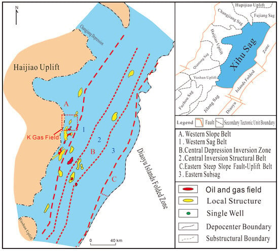
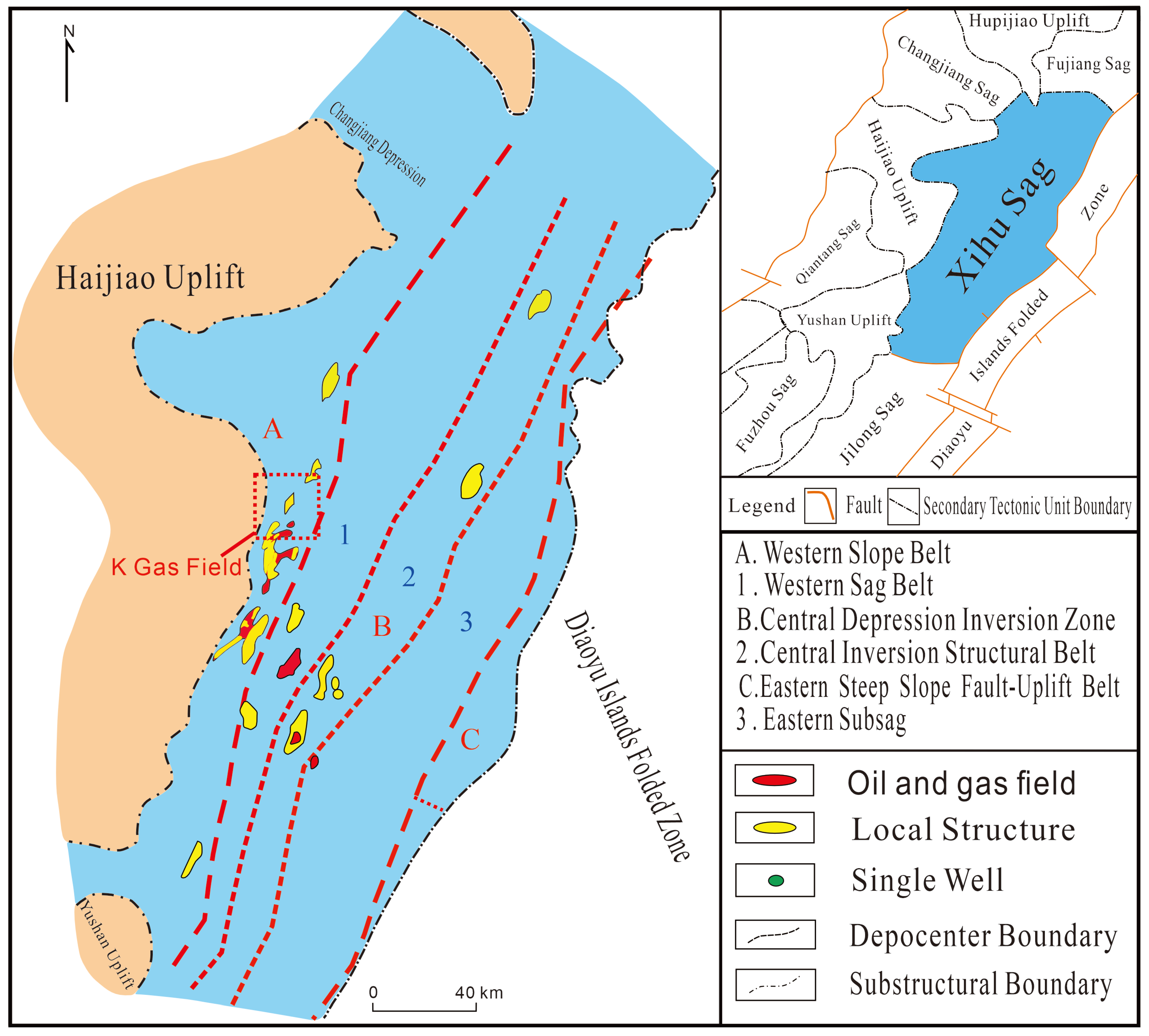
The Xihu Sag is situated in the northeastern part of the East China Sea Basin, trending in a north-northeasterly direction. It is bounded by the Changjiang Sag and the Haijiao Rise to the west, the Diaoyu Island Fold Belt to the east, the Fujiang Sag to the north, and the Jilong Sag to the south [17,18] (Figure 1).
Figure 1.
Tectonic location of the Xihu Depression (modified from Wenbin Jiang, 2012 [19]).
The Xihu Sag exhibits a distinct structural framework characterized by east-west zonation and north-south segmentation. Its secondary structural units include the Western Slope Zone, Western Sub-sag, Central Inversion Structural Belt, Eastern Sub-sag, and Eastern Marginal Fault Zone [20,21]. The overall structural pattern is described as “two sub-sags flanking one central uplift.” The K Gas Field is located in the northern part of the Pinghu Structural Belt within the Western Slope Zone (Figure 1). Specifically, the K Gas Field sits on a nose-shaped uplift belt in the northern Pinghu Structural Belt. Its eastern, central, and western fault blocks form a downward-stepping, dip-ward fault block array [22,23].
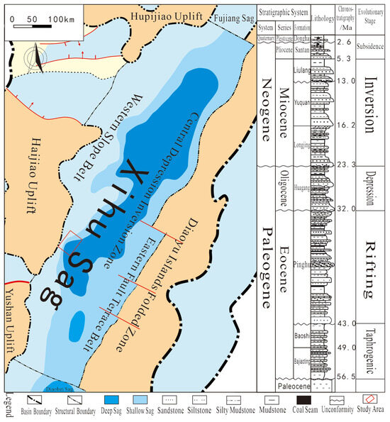
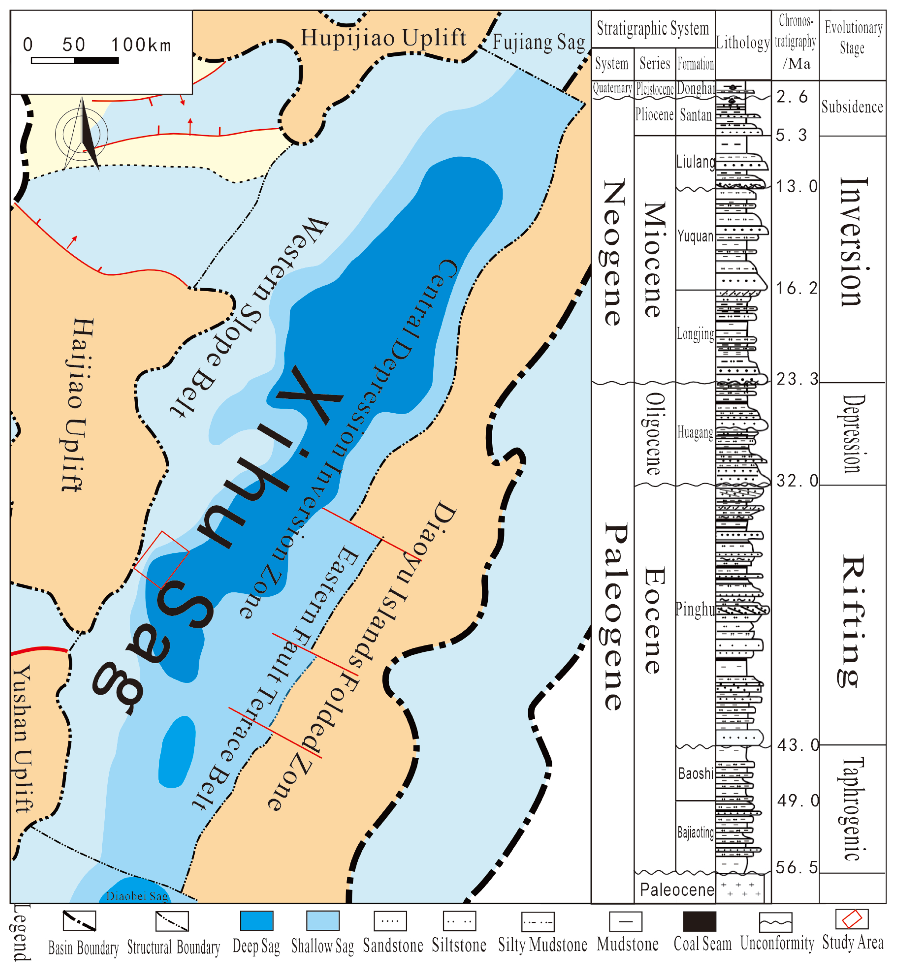
The Xihu Sag features a relatively complete stratigraphic sequence. From bottom to top, it comprises the Lower Eocene Oujiang, Wenzhou, and Baoshi formations; the Middle-Upper Eocene Pinghu Formation; the Oligocene Huagang Formation; the Lower Miocene Longjing Formation; the Middle Miocene Yuquan Formation; the Upper Miocene Liulang Formation; the Pliocene Santan Formation; and the Quaternary Donghai Group [24]. The depositional environment evolved from an early neritic setting through stages of semi-enclosed bay, delta-tidal flat, fluvial, and marine-continental transitional environments, culminating in the present-day shallow marine setting [25]. The Middle-Upper Eocene Pinghu Formation (E2p) consists predominantly of interbedded dark gray mudstone and light gray fine- to coarse-grained sandstone, with well-developed coal seams. It has a thickness ranging from 500 to 1500 m and was primarily deposited in a marine-continental transitional environment. The formation is subdivided into upper, middle, and lower members [5,26]. The Lower Member is characterized by interbedded gray to dark gray mudstone and siltstone/fine sandstone of varying thickness, intercalated with bituminous coal. The Middle Member features an upper part of interbedded siltstone, argillaceous siltstone, coarse sandstone, and mudstone, and a lower part of gray to dark gray mudstone intercalated with fine sandstone and siltstone, with developed coal seams. The Upper Member comprises an upper part of interbedded siltstone, argillaceous siltstone, coarse sandstone, and mudstone, and a lower part of coarse sandstone and pebbly coarse sandstone intercalated with argillaceous siltstone and silty mudstone (Figure 2).
Figure 2.
Tectonic Units Division and Comprehensive Stratigraphic Column of the Xihu Sag (Modified from Niannian Zhang [27]).
2. Materials and Research Methods
2.1. Data Foundation
This study utilizes data from six cored wells (K1–K6) in the K area of the Xihu Depression, including core samples, 3D seismic data, conventional well logs (gamma ray, resistivity, acoustic, etc.), and composite mud logging data. The six cored wells (K1–K6) were selected because they represent all the cored wells in the study area, ensuring comprehensive coverage of the different structural zones—the Kongbei fault-step zone in the north and the Kongnan fault-step zone in the south—and stratigraphic intervals (upper, middle, and lower members of the Pinghu Formation). The coring depths for each well are as follows: K1 (3542.11–3548.31 m, 3565.06–3570.12 m, 3809.01–3814.63 m, and 4047.61–4054.28 m), K2 (3318.64–3325.75 m), K3 (4104–4114 m), K4 (4052–4059 m and 4344–4353 m), K5 (4191.27–4208.99 m), and K6 (4335–4344 m). Conventional coring techniques were employed with a recovery rate exceeding 95%. Core selection followed industry standards, prioritizing intervals with complete core recovery and strong representativeness for detailed observation and description. Through detailed core observation and description, key sedimentological characteristics such as lithology, sedimentary structures (e.g., bedding, scour surfaces), and biogenic traces were systematically documented. Core acquisition and description procedures adhered to industry standards to ensure the accuracy and consistency of sedimentary feature identification.
2.2. Analytical Methods
2.2.1. Petrological Analysis
Lithology identification was conducted through macroscopic core observation combined with thin-section petrographic analysis under a polarized light microscope. Macroscopic observation focused on core color, grain size, sedimentary structures, and bioturbation features. Thin-section analysis was performed on representative samples to determine mineral composition, grain texture, sorting, roundness, and compositional maturity. Based on this integrated approach, the major lithologies of the Pinghu Formation in the study area were identified, including siltstone, fine sandstone, mudstone, argillaceous siltstone, silty mudstone, and coal seams. Sedimentary environments were interpreted by synthesizing lithological assemblages, grain-size characteristics, and sedimentary structures.
2.2.2. Grain-Size Analysis
Grain-size analysis was performed on representative sandstone and siltstone samples using a laser diffraction particle size analyzer (Mastersizer 3000, Malvern Panalytical, Malvern, UK). The grain-size distribution data were processed and plotted using Origin software (2021) to generate probability cumulative curves. Based on the characteristic curve morphologies, such as two-segment saltation, high-gradient two-segment, and three-segment patterns, the transport mechanisms (traction, saltation, suspension) and hydrodynamic conditions were inferred.
2.2.3. Sequence Boundary Identification and Stratigraphic Division
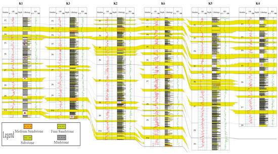
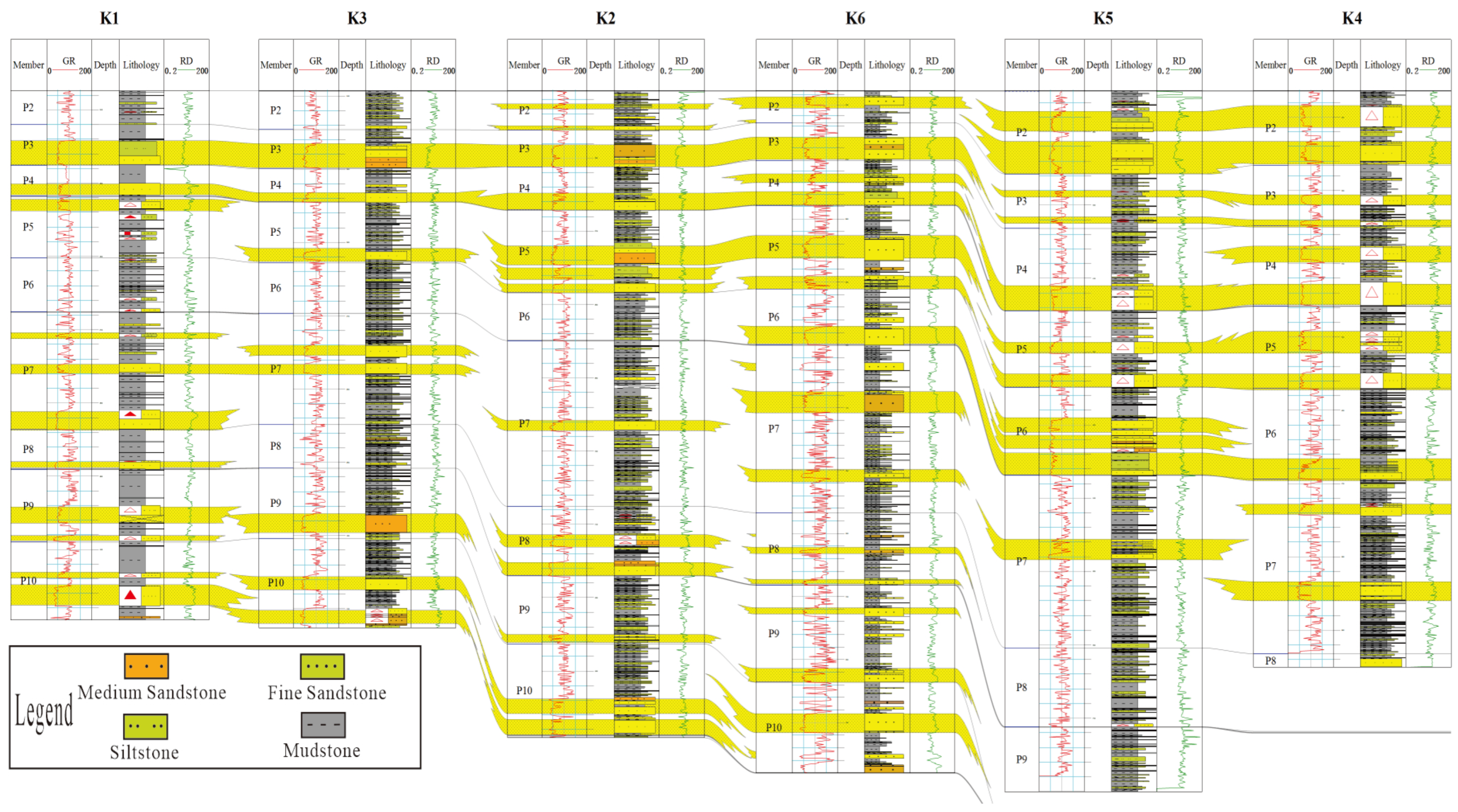
To validate the sequence stratigraphic framework, a comprehensive well-to-well correlation panel was constructed. Figure 3 presents the correlation of six key wells (K1, K3, K2, K6, K5, K4), integrating natural gamma (GR) and deep resistivity (RD) logs with core lithology. This panel illustrates the vertical and lateral continuity of key stratigraphic intervals and sequence boundaries (P2–P10) across the study area. The distinct variations in lithology (e.g., sandstone-mudstone interbedding patterns) and log responses (GR amplitude and RD resistivity) facilitate the identification of depositional packages and their correlation. The continuity of these boundaries demonstrates the regional consistency of the sequence architecture. Notably, sand-rich intervals in wells K3 and K6 suggest potential paleogeographic highs, while thicker mudstone sequences in wells K1 and K5 reflect deeper depositional environments. These observations provide direct evidence for interpreting the spatial distribution of depositional elements within the study area.
Figure 3.
Stratigraphic correlation and logging interpretation of sand groups P2–P10 in wells K1–K6.
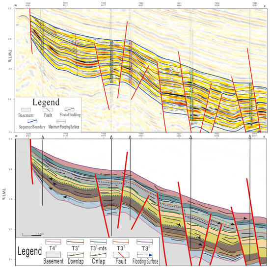
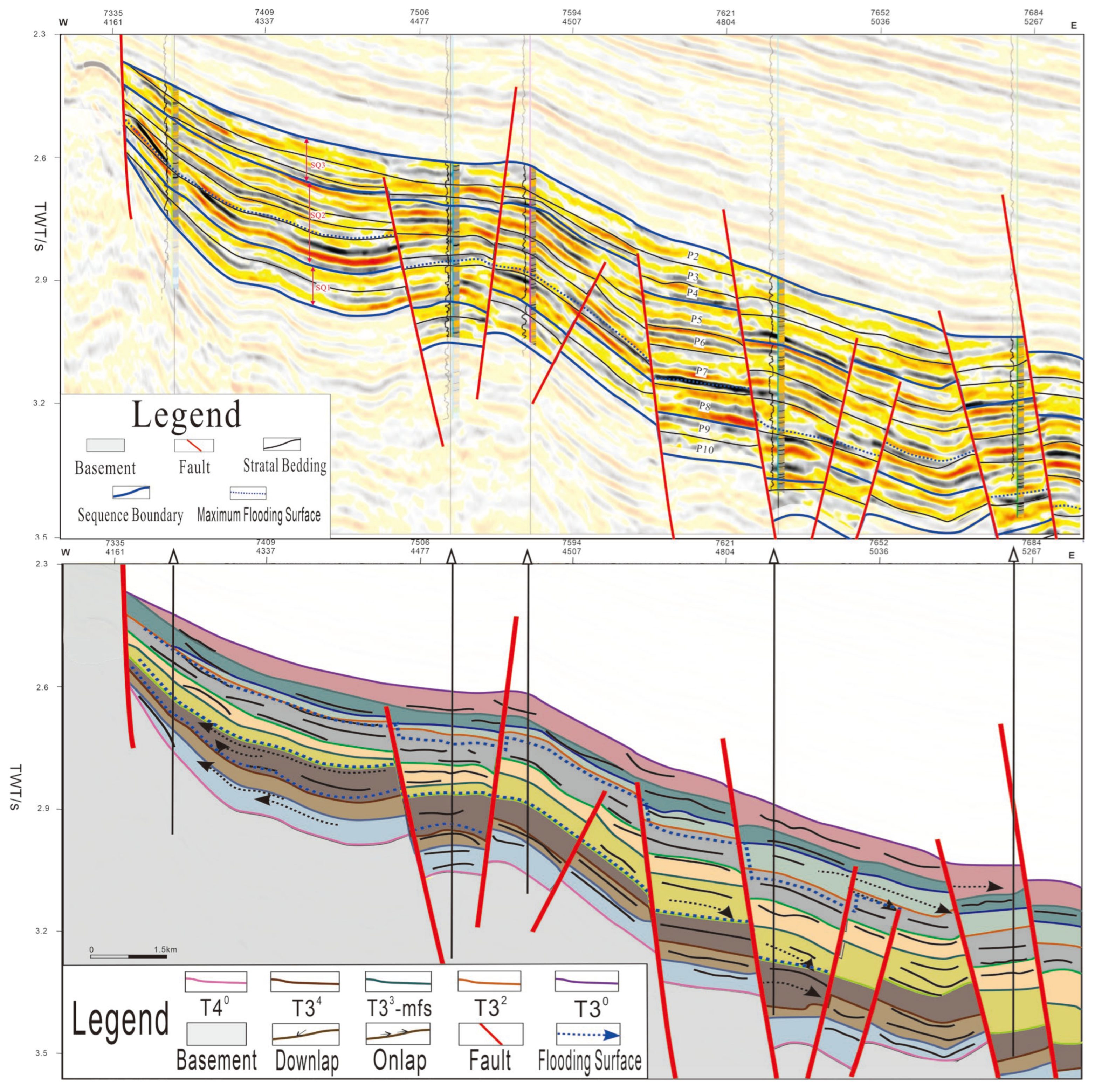
The identification and division of sequence boundaries were conducted based on an integrated dataset comprising 3D seismic data, drilling data, and well logs from the K area of the Xihu Depression. The analysis utilized key diagnostic features, including seismic reflection termination patterns, core characteristics, mud logging responses, and the morphological variations observed in well-logging curves. This integrated approach led to the identification of four sequence boundaries within the Pinghu Formation of the study area. From the base upward, these boundaries are: the base of the Pinghu Formation (base of SQ1/T40), the top of the lower member of the Pinghu Formation (top of SQ1/T34), the top of the middle member of the Pinghu Formation (base of SQ3/T32), and the top of the upper member of the Pinghu Formation (top of SQ3/T30) (Figure 4). The subdivision of the Pinghu Formation into lower, middle, and upper members is therefore based on these regional sequence boundaries, which are recognized by seismic reflection terminations, abrupt shifts in gamma-ray logs, lithological changes, and biostratigraphic constraints from previous studies in the Xihu Sag.
Figure 4.
Sequence Stratigraphic Framework of the Pinghu Formation in the K Gas Field.
2.2.4. Sedimentary Facies Analysis and Model Construction
Within the established sequence stratigraphic framework, sedimentary facies types were identified by integrating lithology, sedimentary structures, vertical sequences, well log responses, and seismic facies characteristics. Through inter-well correlation and planimetric mapping, sedimentary facies distribution maps were constructed for each sequence (SQ1, SQ2, SQ3). This facilitated a comprehensive analysis of the spatiotemporal evolution patterns of the depositional system. Ultimately, differentiated depositional models for the early and late stages within the study area were established. Seismic interpretation and attribute extraction were performed using Petrel software (2024), following standard workflows including horizon picking, fault mapping, and attribute extraction. Sedimentary facies maps and depositional models were compiled using CorelDRAW (2024).
3. Results and Discussion
3.1. Petrological Characteristics
3.1.1. Theoretical Basis
Petrological characteristics represent a fundamental aspect of sedimentological research. Different petrological features are indicative of distinct depositional environments, while the depositional environment, in turn, exerts a primary control on these characteristics.
3.1.2. Rock Types and Characteristics
Based on detailed observation and description of cores from six wells in the Pinghu Formation of the K Gas Field, the main identified rock types are siltstone, fine sandstone, mudstone, argillaceous siltstone, silty mudstone, and coal seams [28].
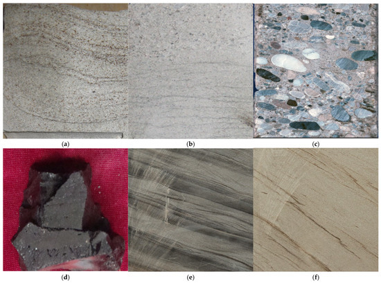
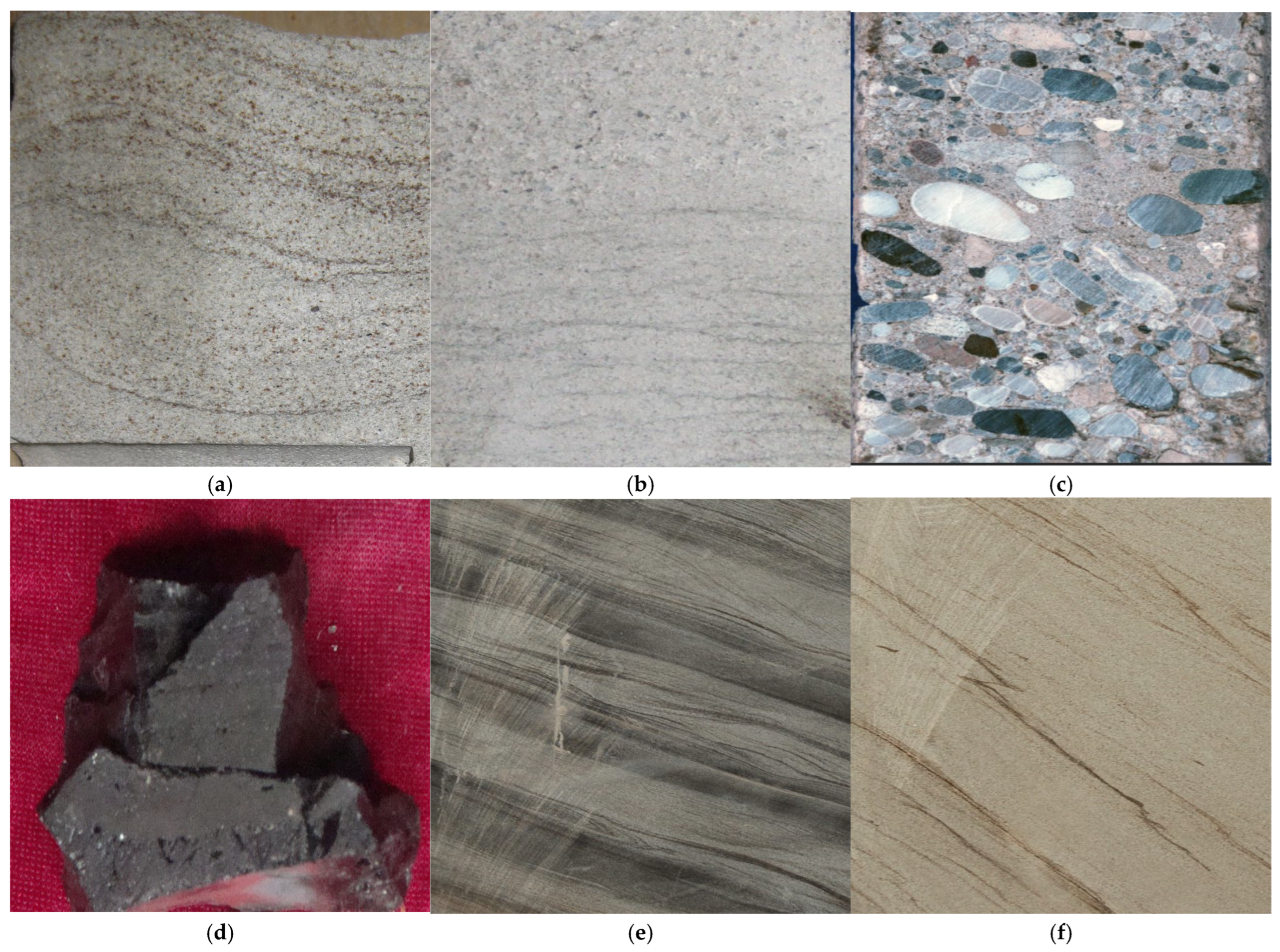
Fine sandstone is predominantly light gray, grayish-white, or yellowish, exhibits normal grading, and shows moderate to good sorting and roundness. It is classified as arkose or lithic sandstone with moderate compositional maturity, indicating a proximal source area and incomplete diagenetic alteration [29] (Figure 5a). Sandy conglomerate displays internal parallel bedding with a basal concentration of lag gravels, suggesting strong hydrodynamic conditions and channel-bottom scouring during deposition [29] (Figure 5b). Grain-supported conglomerate contains well-sorted and rounded clasts arranged in an imbricated fabric, representing a typical indicator of traction current deposition, primarily formed in subaqueous distributary channels of the delta front [30] (Figure 5c).
Figure 5.
Rock types of the Pinghu Formation in the K area. (a) Fine sandstone; tide-influenced subaqueous distributary channel deposits, Well K1, 4047 m. (b) Pebbly coarse sandstone with sharp contact to coarse sandstone; subaqueous distributary channel facies; Well K3, 4111.46 m. (c) Sandy conglomerate; subaqueous distributary channel facies; Well K-5, 4192.72 m. (d) Bituminous argillaceous siltstone; pro-delta facies, Well K-4, 4350.75 m. (e) Silty mudstone; delta plain facies; Well K-6, 4341.8 m. (f) Silty mudstone; delta plain facies; Well K-6, 4340.8 m.
Argillaceous siltstone consists mainly of silt-sized quartz, feldspar, and clay minerals, exhibiting poor sorting and a dark gray to black color. It displays horizontal or massive bedding with weak to no bioturbation. This rock type forms in stratified, anoxic bottom-water environments such as the pro-delta or restricted lagoons, which favor organic matter preservation and often constitute high-quality source rocks [31] (Figure 5d).
Silty mudstone, a low-energy depositional unit of the delta plain subfacies, comprises a heterogeneous mixture of silt and clay minerals. It shows reverse grading vertically, is predominantly gray, and locally exhibits minor cross-bedding, basal scour surfaces, and oriented brown mud clasts (Figure 5f). Some intervals show uneven, banded clay distribution and develop ripple marks, flaser bedding, and lenticular bedding (Figure 5e), reflecting suspended sedimentation in quiet-water environments such as interdistributary depressions or floodplains. This rock type is rich in plant stem and leaf fragments, root traces, and siderite or pyrite nodules. Together with distributary channel sands and peat (coal seams), it forms “sand-mud-coal” sedimentary cycles, recording the aggradational evolution of the delta plain and indicating a broad, low-relief coastal morphology during the depositional period [7,32].
Mudstone is gray to dark gray and contains abundant, diverse biogenic burrows and mixed bedding, accompanied by flaser, lenticular, and wavy bedding. The bioturbation indicates a shallow-water environment with sufficient oxygen and thriving benthos, while the flaser, lenticular, and wavy bedding result from mixed sand-mud deposition under tidal or storm influences. These combined characteristics suggest formation in semi-enclosed bays or interdistributary depressions affected by periodic hydrodynamics, providing key evidence for identifying micro-geomorphic features in marine-continental transitional settings.
The distribution and characteristics of coal seams systematically record the evolution of the deltaic dynamic environment. During the early tide-dominated phase, delta plain peat swamps formed widely distributed, uniformly thick, clay-rich primary coal seams under stable groundwater levels and periodic fresh-to-brackish water influx, with both roof and floor consisting of tidal flat silty mudstone [33]. In the late delta front phase, significantly enhanced hydrodynamics eroded and reworked earlier peat and unconsolidated coal. The redeposited peat debris formed thin coal seams associated with channel sands in low-energy settings. The transition from primary to detrital coal completely reveals the evolutionary history of the deltaic system from a constructional to a reworking phase.
3.1.3. Grain Size Distribution Characteristics
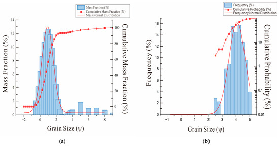
The grain-size probability cumulative curves of the Pinghu Formation in the K area display multiple types [34], including a multi-segment pattern with two saltation components, a high-gradient two-segment pattern, and a three-segment pattern, reflecting distinct hydrodynamic conditions during deposition [34].
The multi-segment pattern with two saltation components exhibits a wide grain-size distribution and poor sorting, with well-developed saltation sub-populations. Composed mainly of fine- to coarse-grained sandstones, it indicates high-energy, unstable, and intermittent (pulsatory) hydrodynamic conditions, characteristic of subaqueous distributary channel deposits in a proximal fan-delta front [35] (Figure 6a).
Figure 6.
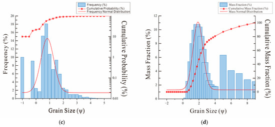
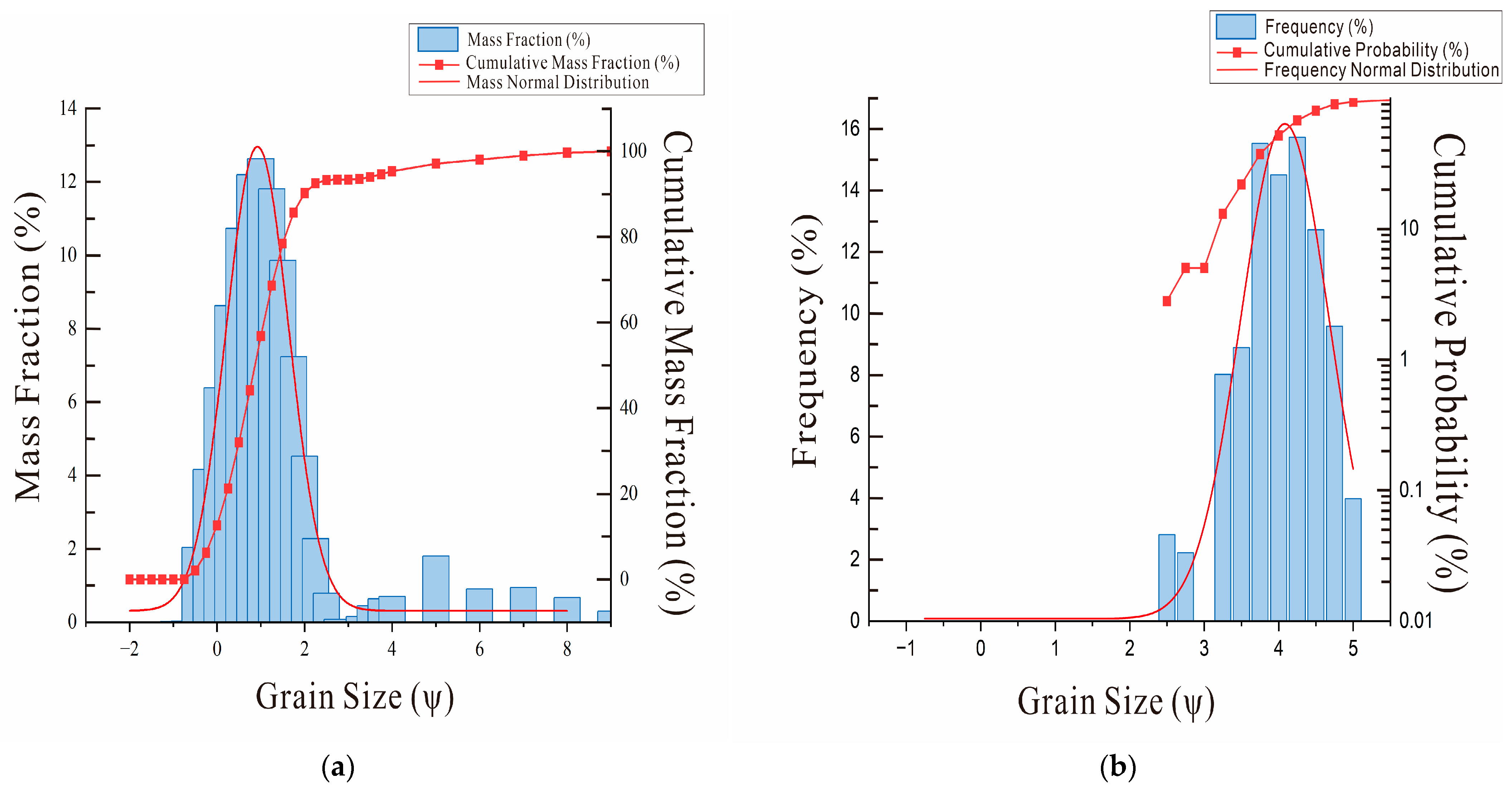
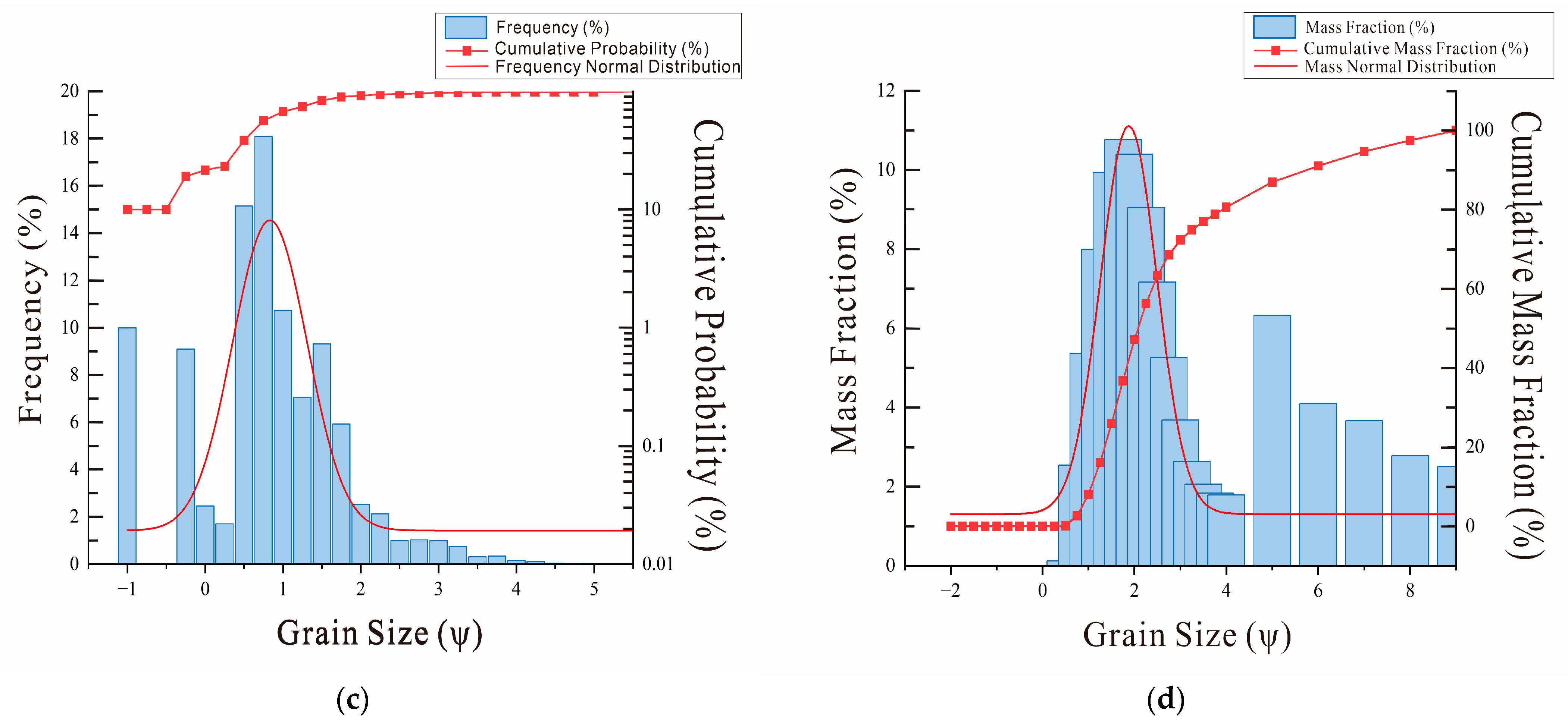
Cumulative probability curves of grain size for the Eocene Pinghu Formation (K). (a) Bimodal saltation multi-segment, K-3, 4105.06 m. (b) High-gradient two-segment, K-2, 4087 m. (c) High-gradient three-segment, K-2, 4099 m. (d) Upward-concave, K-5, 4191.47 m.
The high-gradient two-segment pattern shows a narrow grain-size distribution and good sorting, predominantly of silty mudstone and fine sandstone. With grain-size (Ψ values) mainly concentrated between 3.5 and 5, it reflects a weak but stable current, typical of deposits such as sheet sands and nearshore-shallow lacustrine sand bars (Figure 6b).
The three-segment pattern comprises traction, saltation, and suspension components (Figure 6c). It has a narrow grain-size distribution (mainly siltstone, silty mudstone, and fine sandstone) and good sorting. This pattern suggests complex yet overall traction-current-dominated hydrodynamic conditions [36].
The upward-concave arc pattern (or upward-arc western-segment type) consists of poorly sorted, heterogranular sandstone with a well-developed suspension sub-population. It represents poor sorting and exhibits characteristics of finer-grained, suspension deposition associated with turbidity currents (Figure 6d).
The grain size distribution characteristics of the Pinghu Formation in the K gas field indicate the presence of two distinct types of hydrodynamic conditions: complex hydrodynamic processes dominated during the early stage, while stable and relatively uniform fluvial hydrodynamic conditions prevailed in the late stage.
3.2. Depositional System Evolution in Sequence Stratigraphic Framework
Based on the established sequence stratigraphic framework (Figure 4) and through systematic analysis of sedimentary facies within each sequence unit, the study reveals that the depositional system of the Pinghu Formation in the K area exhibits a clearly staged evolutionary trend. The results indicate that its sedimentary dynamics and sandbody distribution underwent a complete transition, evolving from a tide-dominated regime in the early stage, through a river-tide interactive stage in the middle stage, to an absolutely river-dominated system in the late stage. Specifically, three evolutionary stages are recognized: the early stage (E2pSQ1), characterized by a tide-dominated delta, the middle stage (E2pSQ2), characterized by fluvial–tidal interaction, and the late stage (E2pSQ3), characterized by an overwhelmingly fluvial-dominated system.
3.2.1. Depositional Evolution During the E2pSQ1 Stage
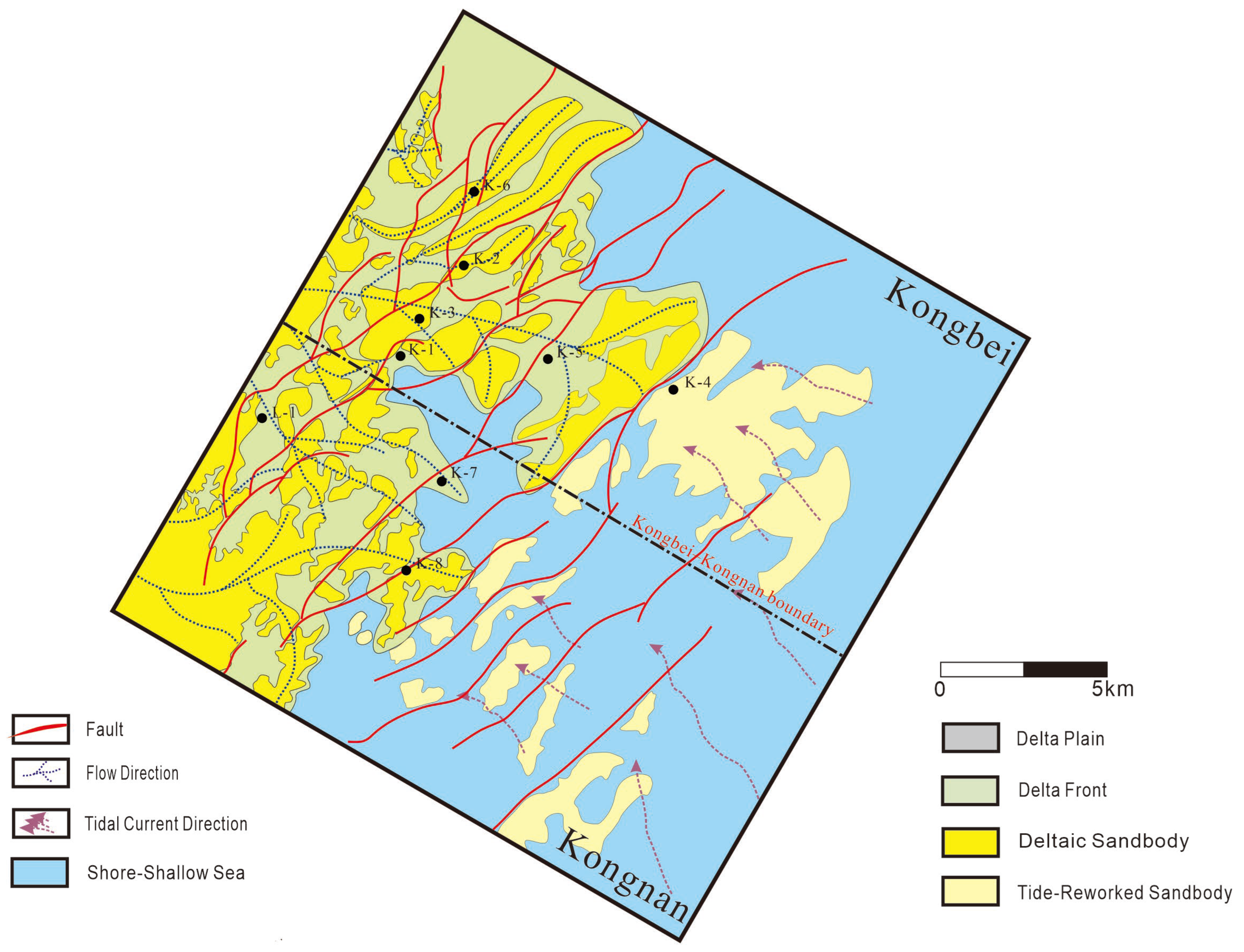
The E2pSQ1 stage represents the initial phase of depositional evolution in the study area, dominated by a tide-influenced deltaic system with pronounced stage-specific characteristics in depositional dynamics and facies distribution. Spatially, the sedimentary facies configuration during this period exhibits a dual-system pattern, comprising a fluvial-dominated delta in the north and a tide-dominated delta in the south (Figure 7). The northern fluvial-dominated delta was sourced by terrigenous clastics delivered through regional drainage networks, with distributary-channel sandbodies as its fundamental architectural elements. However, its development was significantly restricted by the strong tidal regime prevailing in the south, which limited both the spatial extent and hydrodynamic intensity of fluvial processes. As a result, the fluvial-dominated delta remained a subsidiary depositional system within the overall tide-dominated setting, forming a distinct spatial coupling pattern characterized by “fluvial influence in the north versus tidal dominance in the south,” with clear primary-secondary differentiation relative to the extensively developed southern tide-dominated delta.
Figure 7.
Distribution of Sedimentary Faciesin the K Area During the E2pSQ1 Period.
3.2.2. Depositional Evolution During the E2pSQ2 Stage
During the E2pSQ2 period, the sedimentary system in the K region underwent a significant evolutionary phase, marked by a pronounced expansion and a systematic northward migration of the fluvial-dominated sedimentary facies zone compared to the E2pSQ1 period. This spatial reorganization, with the core depocenter shifting from the south to the north, indicates a fundamental change in the regional sedimentary dynamics. A key driver was the systematic intensification of sediment supply. Enhanced terrigenous input directly strengthened fluvial processes and expanded their spatial distribution, resulting in a relatively widespread fluvial-dominated infill pattern that constitutes the most diagnostic sedimentary signature of this stage [37]. Concurrently, the spatial extent of the intertidal depositional environment was significantly compressed, reflecting a co-evolutionary relationship between the sedimentary dynamic regime and environmental conditions.
In terms of specific processes and distribution, the intensified fluvial sedimentation was focused along the K Northern Fault-Terrace Belt, a critical paleogeomorphic unit, where sediments converged and then dispersed. This formed a belt-like, fluvially, dominated system that progressively prograded southward. This distribution pattern was demonstrably constrained by the pre-existing tectonic framework and paleotopographic trends, highlighting the control of structure and geomorphology on sedimentation.
A critical shift in depositional environment also occurred during E2pSQ2. The earlier middle-to-deep marine setting had completely withdrawn from the study area, transitioning to a broad shallow-marine environment. This shift, attributable to relative sea-level fall or sedimentary filling and shallowing of the basin floor, established the essential preconditions for developing large-scale shallow-water delta systems.
Consequently, the deltaic system underwent a marked transformation, evolving from the tide-dominated regime prevalent during E2pSQ1 to one dominated by fluvial processes in E2pSQ2. The river-dominated deltas of this period exhibited distinctive digitate or lobate planform geometries. Their frontal zones featured multiple, sizable, linear tidal sand ridges. This composite sedimentary assemblage reflects a complex hydrodynamic origin: proximal deposition was primarily controlled by strong fluvial construction, with riverine transport dominating sediment delivery. In contrast, in the distal shallow-water setting, sediments were continuously reworked, sorted, and redistributed by tidal currents. The resulting deposits thus record a characteristic fluvial-tidal interaction, capturing the synergistic effects of these forces during this key phase of sedimentary evolution.
3.2.3. Depositional Evolution During the E2pSQ3 Stage
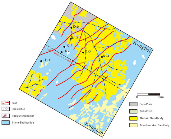
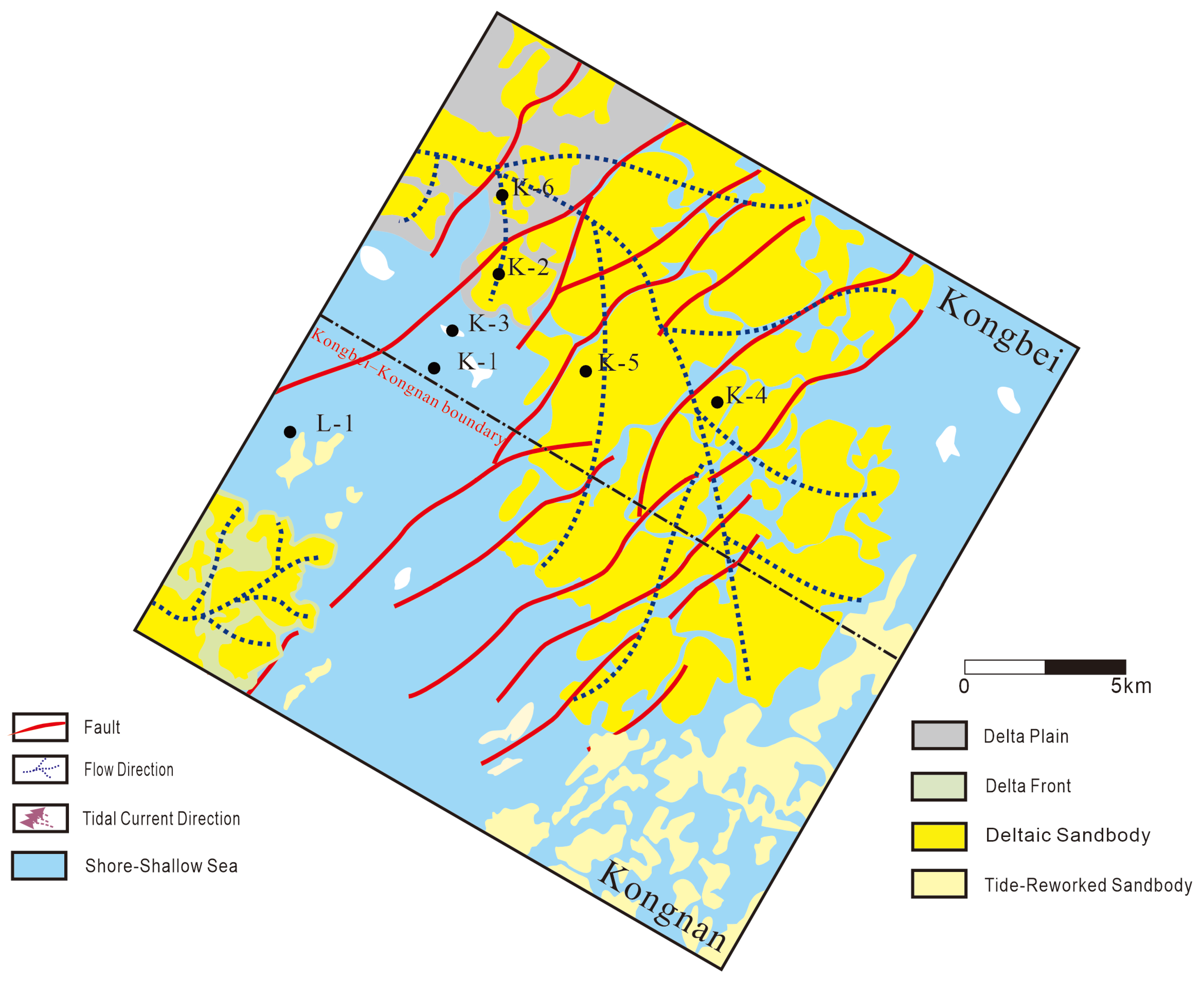
During the E2pSQ3 period, sedimentary evolution in the study area was governed by the coupling of two critical controls: first, the persistent and robust progradation of large-scale fluvial systems, which significantly enhanced sediment transport capacity and sedimentary dynamics; second, a marked, staged decline in regional relative sea level, as indicated by the progressive shallowing of depositional environments and the basinward shift of coastal facies documented in this study, resulting in a continuous contraction of basin accommodation space (Figure 8). The synergy of these factors established fluvial sedimentary dynamics and geomorphic shaping as the overwhelmingly dominant force, constituting the core driver of sedimentary system evolution in this interval.
Figure 8.
Sedimentary Facies Distribution during the E2pSQ3 Period.
Under this dynamic regime, the fluvial-dominated sedimentary facies belt underwent extensive expansion during E2pSQ3, reaching its maximum spatial extent within the documented evolutionary sequence. Its distribution covered most of the study area, forming a widespread and contiguous fluvial-dominated sedimentary infill system. This system represents the most significant paleogeographic indicator of the period, exemplifying the homogenization and large-scale distribution pattern of the sedimentary system. In stark contrast to the supremacy of fluvial processes, tidal influence was severely restricted, confined to only a few highly localized areas, underscoring the absolute dominance of river-driven sedimentation in shaping the regional depositional architecture.
This sedimentary signature clearly indicates that within the regional setting of low sea level and exceptionally strong fluvial dominance, tidal energy could only persist in relatively low-lying topographic zones or remnant depressions adjacent to paleo-tidal channels. Its reworking capacity within the regional sedimentary system was no longer comparable to the dominant fluvial sedimentary dynamics. Consequently, during the E2pSQ3 period, the K region ultimately evolved into a depositional framework overwhelmingly dominated by fluvial-controlled deltas, marking a pivotal transitional phase in the regional sedimentary evolution.
In summary, the depositional system of the Pinghu Formation in Block K exhibits a clear evolutionary trend from tidal dominance in the early stage (E2pSQ1) to fluvial dominance in the late stage (E2pSQ3), with a transitional phase of fluvial–tidal interaction in the middle stage (E2pSQ2).
3.3. Sedimentary Models of the Early and Late Pinghu Formation
The depositional system in the study area is governed by the dynamic interplay between fluvial and tidal processes. This interaction can be conceptualized as a balance between fluvial energy, primarily controlled by sediment supply and discharge, and tidal energy, influenced by basin physiography and relative sea level. The relative dominance of these two energy regimes, modulated by tectonic activity and eustatic sea-level changes, determines the resulting depositional architecture. Based on this conceptual framework, two differentiated sedimentary models are established for the Pinghu Formation in Block K.
Based on the systematic identification of sedimentary facies and microfacies in the study area, it is recognized that competition between tidal and fluvial processes has persistently existed along the western slope belt of the East China Sea Shelf Basin. A systematic analysis of the sedimentary system architecture indicates that multiple types of sedimentary systems have developed in this region. Their genetic mechanisms are constrained not only by fundamental geological elements such as paleogeomorphology and fault structures, but also, critically, by the coupled variations between fluvial intensity (driven by sediment supply) and tidal energy. This coupling represents a core factor controlling the diversification of sedimentary systems within the western slope belt [38]. As a result, the types of sedimentary facies and subfacies in the study area are dominated by fluvial-controlled and tide-controlled depositional systems. Building on the distribution patterns and evolutionary characteristics of these two predominant sedimentary facies, two distinct sedimentary models for the Pinghu Formation have been established.
3.3.1. Early-Stage Tectonically Constrained Fluvial-Tidal Interaction Model
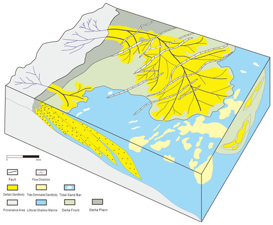
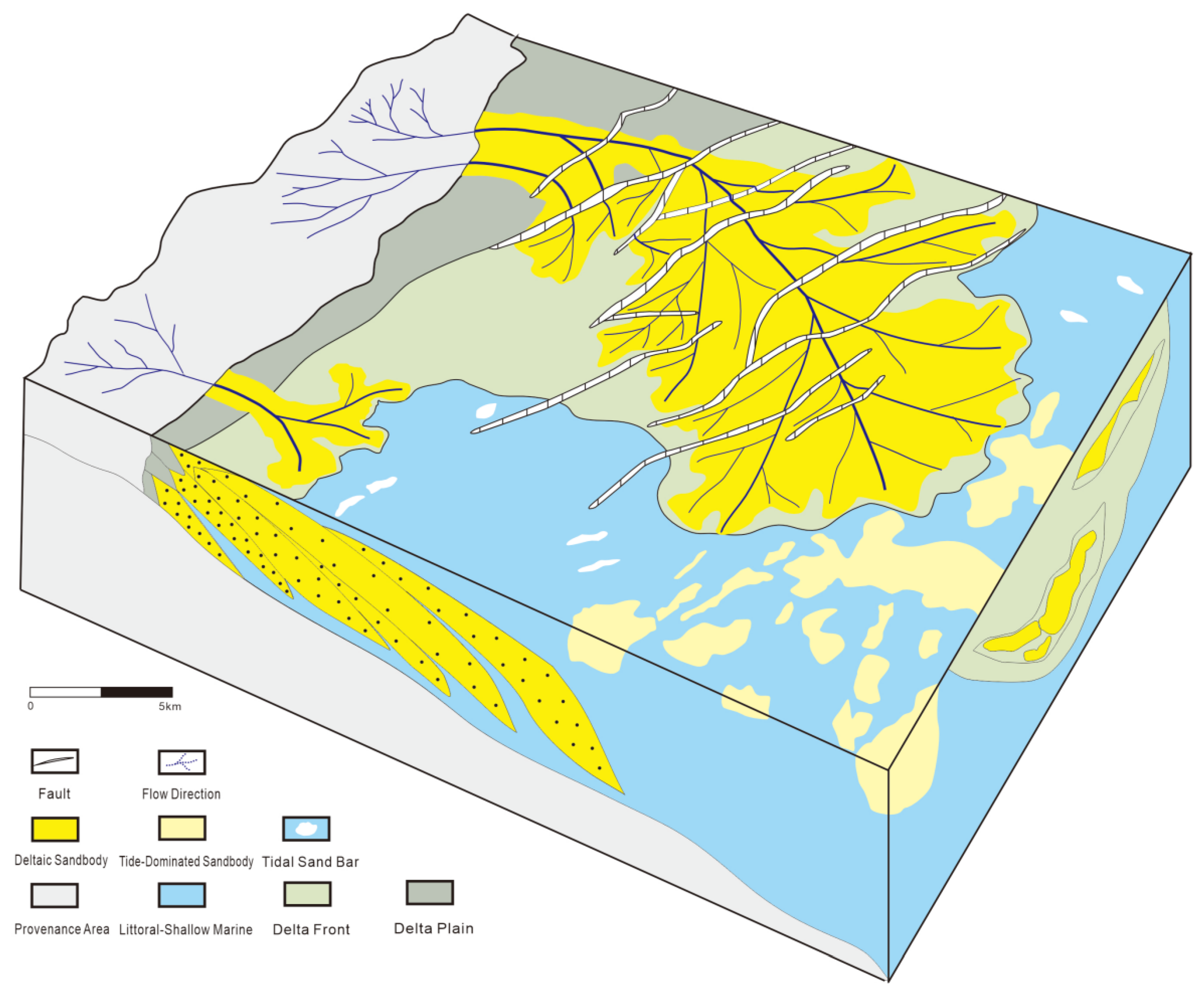
This sedimentary model is primarily developed within the northern K fault-step zone. Clastic materials derived from extrabasinal source areas were transported into the depositional basin through paleo-valley conduits, forming a deltaic system downdip along the slope belt (Figure 9). In the western part of the model, the terrestrial source area provided topographic relief that facilitated sediment transport, with dendritic fluvial networks acting as the primary pathways for clastic delivery. The sediment supply was dominated by terrigenous detritus.
Figure 9.
Sedimentary Model for the Early Pinghu Formation in the KB Platform Area.
Adjacent to the source area, the transitional zone comprises the delta plain facies. Here, delta plain channels exhibit a ribbon-like or belt-like distribution, forming the principal conduits for delivering clastic sediment basinward. Interdistributary bays are developed on both flanks of these channels, characterized by mudstone and silty mudstone lithologies typical of floodplain deposition. Deltaic sand bodies are preferentially concentrated in linear trends at the channel termini, constituting the dominant reservoir facies within the delta plain zone [39].
The delta front progrades basinward into the delta-front facies, a zone situated within the dynamic interplay of fluvial and marine processes. This area retains the tractive current energy from upstream channels, leading to the development of sand bodies such as mouth bars and sheet sands, while simultaneously undergoing tidal reworking which disperses sediments into sheet-like or dendritic patterns. Dominated lithologically by fine sandstone and siltstone, these deposits exhibit superior sorting compared to sand bodies within the delta plain facies [40].
The southeastern sector of the study area comprises the littoral to shallow-marine facies, which acts as the ultimate depocenter for terrigenous clastic material. Depositional dynamics here are governed predominantly by tidal energy. Delta-front sand bodies entering this environment are reworked by tidal hydrodynamics into tide-dominated sand bodies. These occur as patchy accumulations within a shallow-marine muddy matrix, constituting potential reservoir units within the littoral to shallow-marine facies succession [41].
Concurrently, facies-controlling faults exert a fundamental influence: their vertical displacement modulates the creation of accommodation space, while their planar geometry constrains the spatial orientation of sedimentary units. This structural control is evidenced by the preferential concentration and alignment of sand bodies along fault trends, underscoring the “boundary-limiting” role of tectonism on the sedimentary system architecture.
The genesis of this sedimentary model is attributed to the synergistic interaction between fluvial and tidal hydrodynamics. Its evolutionary pathway can be delineated into two distinct stages:
- Source-to-Sink Transport and Sorting Stage: Terrigenous clastics, eroded from the provenance area, are transported via tractive currents through delta-plain channel networks. Initial sorting occurs within these channels, resulting in the retention of coarse-grained lag deposits at the channel base, while finer-grained fractions are carried further basinward by the flow. The formation of interdistributary bays through periodic channel avulsion preserves a record of the intermittent hydrodynamic regime characteristic of the delta plain environment.
- Frontal Depositional and Tidal Reworking Stage: As fluvial effluent enters the delta front zone, the abrupt increase in water body expanse coupled with a rapid decrease in flow velocity triggers the quick deposition of coarse clastics to form mouth bars. Concurrently, landward-intruding tidal currents winnow and rework these newly deposited sands. This tidal modification enhances sediment sorting, further reduces grain size, and redistributes the sands into linear belts along tidally influenced channels. The final product is a composite sand body characterized by an initial fluvial depositional imprint subsequently overprinted by tidal reworking.
3.3.2. Late-Stage Tectono-Eustatic Coupling Fluvially-Dominated Sedimentary Model
The late-stage sedimentary model in the K region underwent a fundamental transformation compared to the early stage, an evolutionary process governed by the coupling of tectonic evolution and sea-level change. During the late phase of tectonic activity, regional tectonism intensified. The Haijiao Uplift in the source area entered a stage of sustained uplift, with significantly enhanced tectonic denudation associated with this process. This led to a sharp increase in sediment supply, providing a substantial detrital foundation for the development of a large-scale deltaic system [42].
Simultaneously, regional sea level entered a cycle of relative fall. The lowering of the base level markedly enhanced the erosional, transportational, and progradational capacity of the fluvial system, driving the river-dominated depositional system to extend progressively basinward [4].
The combined effect of strong sediment influx and the shallow-water setting created by relative sea-level fall caused the zone of tidal influence to contract basinward. The reworking effect of tidal dynamics on the deposits weakened, while fluvial hydrodynamics gradually replaced tidal forces as the dominant agent shaping the sedimentary bodies [4]. During this period, the northern part of the study area, controlled by a multi-level step-fault structural pattern, experienced significantly higher fault activity intensity in the northern fault-step zone than in the southern zone. The intense differential subsidence within this zone, superimposed with the continuous uplift of the adjacent Haijiao source area, generated pronounced tectonic-morphological relief [28].
This relief effect substantially enhanced the downcutting erosional capability and sediment transport efficiency of the fluvial system in the northern fault-step zone, ultimately forming a long-term, stable, and active “high-supply, high-progradation” deltaic channel system.
In stark contrast, the southern fault-step zone, constrained by lower fault activity, gentler topographic relief, and longer sediment transport pathways, developed a “low-supply, low-progradation” system characterized by shallow-water meandering or distributary channels. Its fluvial network was limited in scale, prograding a shorter distance basinward, with both the lateral continuity and vertical stacking thickness of its sedimentary bodies being significantly lower than those in the north [43].
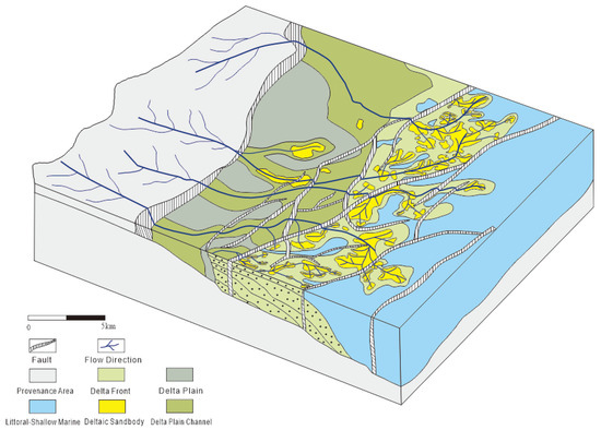
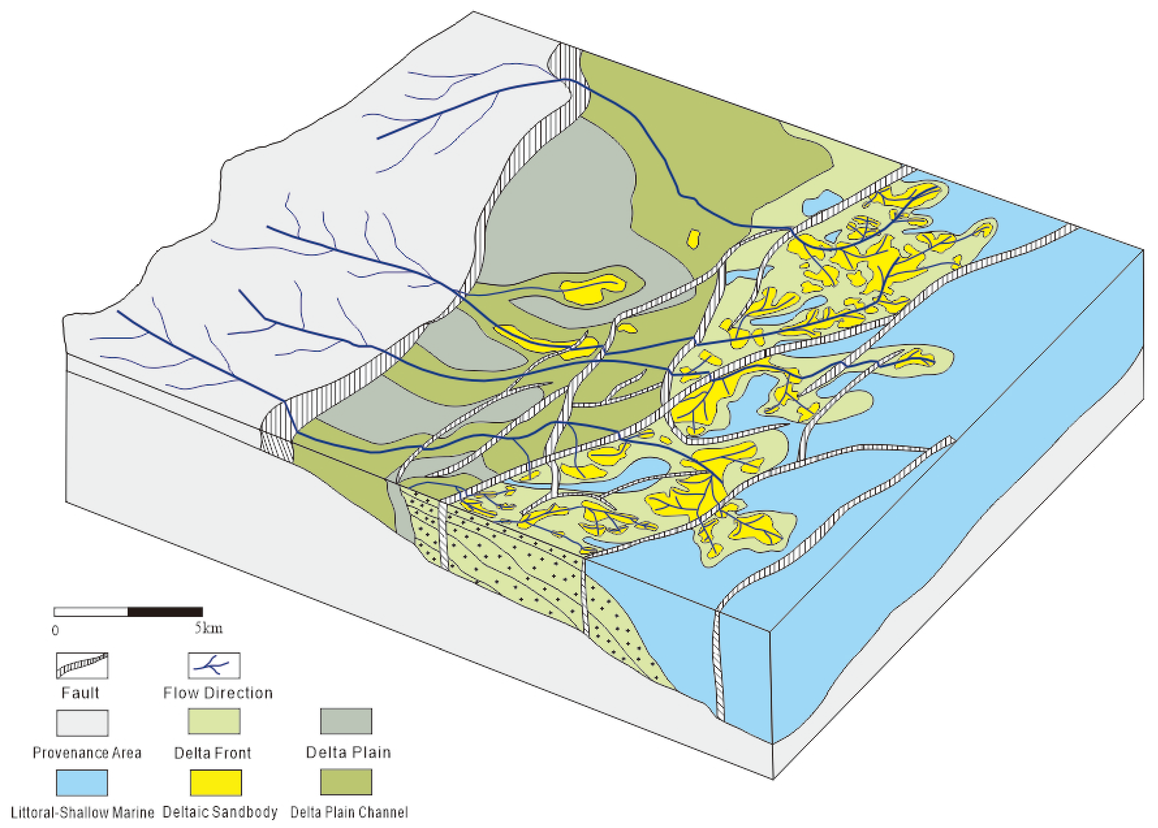
In summary, the depositional model for the lowstand systems tract of the Upper Pinghu Formation in the K region (Figure 10) involved an initial rapid relative sea-level fall followed by a slow rise. Paleotopography exhibited a west-high, east-low trend from the source area to the depositional center, resulting in continuously increasing accommodation space and progressive deltaic progradation toward the depocenter. During this phase, tidal reworking of the delta front diminished, forming tidal sand ridges and tidal channels along the front. Concurrently, with increasing sediment supply and the growing dominance of fluvial processes, channel bifurcation increased, mouth bars became the primary sand bodies, and tidal flat deposits were confined to local development along the flanks of the delta system [44,45].
Figure 10.
Late-stage sedimentary model for the Pinghu Formation in the B Platform area.
The depositional models established in this study demonstrate a complete transition from tide-dominated to fluvial-dominated deltaic systems under the coupled control of sediment supply and relative sea-level change. This evolutionary pattern, characterized by the progressive dominance of fluvial processes and the differential sedimentary responses between fault-step zones, may serve as a reference for understanding similar marine-continental transitional deltaic systems in other basins.
4. Conclusions
- (1)
- The Pinghu Formation in Block K exhibits diverse lithologies and multiple grain-size distribution patterns, reflecting complex hydrodynamic conditions. The early stage was characterized by tidal-dominated processes with fluvial influence, while the late stage was dominated by fluvial processes.
- (2)
- The depositional system evolved through a complete sequence: tide-dominated delta in the early stage (E2pSQ1), fluvial–tidal interaction in the middle stage (E2pSQ2), and fluvial-dominated system in the late stage (E2pSQ3). This evolution was controlled by the combined effects of increasing sediment supply and episodic relative sea-level fall, with the transition mechanism primarily governed by tectono-eustatic coupling.
- (3)
- These differentiated models reveal, for the first time, the contrasting sedimentary responses to tectono-eustatic coupling between the Kongbei and Kongnan fault-step zones. In the lowstand systems tract, a “high-supply, high-progradation” fluvial-dominated delta developed in the Kongbei fault-step zone, whereas a “low-supply, low-progradation” minor fluvial system formed in the Kongnan fault-step zone. In contrast, the highstand systems tract was dominated by a tide-dominated delta in the Kongnan fault-step zone, while the Kongbei fault-step zone remained a minor fluvial system.
- (4)
- The evolutionary pattern documented in this study, characterized by the complete transition from tide-dominated to fluvial-dominated deltaic systems under coupled tectono-eustatic control, may serve as a reference for understanding similar marine-continental transitional deltaic systems in other basins.
Author Contributions
Conceptualization, S.L. and Y.W.; methodology, S.L. and L.Z.; software, Y.W. and Y.Z.; validation, S.J., W.W. and Y.Z.; formal analysis, S.L., L.Z. and Y.W.; investigation, S.J., Y.W., L.Z., W.W., Y.Z. and Y.W.; resources, S.J. and W.W.; data curation, S.J. and Y.W.; writing—original draft preparation, S.L.; writing—review and editing, S.L., Y.W. and Y.W.; visualization, S.L., Y.W. and Y.Z.; supervision, S.J., Y.W. and Y.Z.; project administration, S.J. and L.Z.; funding acquisition, S.J. All authors have read and agreed to the published version of the manuscript.
Funding
This research was funded by the National Key Research and Development Program of China “Key Technologies for Exploration and Development to Ramp Up Natural Gas Production to 7 Billion Cubic Meters per Year and Maintain a Ten-Year Plateau in the East China Sea” (Grant No. E-Y424RY03.05).
Institutional Review Board Statement
Not applicable.
Informed Consent Statement
Not applicable.
Data Availability Statement
All data and materials are available on request from the corresponding author. The data are not publicly available due to ongoing researches using a part of the data.
Conflicts of Interest
Shuangshuang Li, Lan Zhang and Wei Wang were employed by the CNOOC (China) Limited Shanghai Branch, Shanghai, 200030, China. The remaining authors declare that the research was conducted in the absence of any commercial or financial relationships that could be construed as a potential conflict of interest.
References
- Diao, H.; Liu, J.S.; Hou, D.J. Characteristics of coal-measure source rocks in fault-depression transition period in offshore China: A case study of source rocks of Pinghu Formation in Xihu Sag. Mar. Geol. Quat. Geol. 2019, 39, 102–114. [Google Scholar] [CrossRef]
- Jiang, Y.M.; He, X.J.; Tang, X.J. Material Composition of the Diaoyu Island Uplift–Fold Belt and Re-recognition of the Eastern Boundary of the Prototype Basin in the Xihu Sag, East China Sea. Earth Sci. 2019, 44, 773–783. [Google Scholar] [CrossRef] [Scilit]
- Chen, Z.Y.; Du, X.B.; Li, S. Distributional Signatures of Depositional System of Pinghu Formation, Pinghu Slope, Xihu Sag, East China Sea Shelf Basin. Pet. Geol. Exp. 2022, 44, 780–789. [Google Scholar] [CrossRef]
- Yu, S.; Sedimenta Wu, F.; Ren, P.G.; Tan, M.X. Sedimentary Facies Evolution of the Pinghu Formation in Kongqueting Area of the Xihu Sag, East China Sea and Its Main Controlling Factors. Mar. Geol. Quat. Geol. 2022, 42, 119–130. [Google Scholar] [CrossRef]
- Jiang, Y.M.; Zhou, Q.Y.; Li, S.; Zhang, X. Reconsideration of Pinghu Formation Coal-Bearing Rock Series Sedimentary Environment in Western Slope of Xihu Depression. Coal Geol. China 2016, 28, 18–25. [Google Scholar]
- Yu, S. Depositional Genesis of Source Rocks of the Pinghu Formation in the West Slope, Xihu Sag, East China Sea. Earth Sci. 2020, 45, 1722–1736. [Google Scholar] [CrossRef] [Scilit]
- Wei, H.F.; Chen, J.F.; Chen, X.D.; Cao, B.; Guo, W.; Zhang, J.H. The Controlling Factors and Sedimentary Environment for Developing Coastal Coal-Bearing Source Rock of Pinghu Formation in Xihu Depression. Geol. China 2013, 40, 487–497. [Google Scholar]
- Tian, Y.; Ye, J.R.; Lei, C. Developmental Model of Source Rocks of Transitional Facies in Fault Basins: A Case Study of Pinghu Formation, Xihu Sag. Earth Sci. 2019, 44, 898–908. [Google Scholar] [CrossRef] [Scilit]
- Zhou, X.H.; Jiang, Y.M.; Tang, X.J. Basin-forming Setting, Prototype Basin Evolution and Exploration Implications in Xihu Sag, East China Sea. China Offshore Oil Gas 2019, 31, 1–10. [Google Scholar]
- Jiang, Y.M.; Zhao, H.; Tang, X.J. Sedimentary Environment and Facies Types of the Eocene Baoshi Formation in Pingbei Area of Pinghu Slope, Xihu Sag, East China Sea Basin. Pet. Geol. Exp. 2025, 47, 941–950. [Google Scholar]
- Longhitano, S.G.; Mellere, D.; Steel, R.J.; Ainsworth, R.B. Tidal depositional systems in the rock record: A review and new insights. Sediment. Geol. 2012, 279, 2–22. [Google Scholar] [CrossRef] [Scilit]
- Duan, D.P.; Cai, H.; Ruan, J.X. Fine Study on Sedimentary Microfacies of PH Formation in X Oilfield: A Case Study of FHT Area. Offshore Oil 2015, 35, 42–46. [Google Scholar]
- Xu, G.S.; Wang, W.X.; Zhao, Z.S. Peat Accumulation in the Lower Delta Plain Affected by Tides. Coal Geol. Explor. 1997, 25, 9–12. [Google Scholar]
- Wang, J.; Wang, H.; Fan, J.; Zhao, J. Geochemical Characteristics of Late Permian Coal in Western Guizhou, China, and Their Paleoenvironmental Significance. ACS Omega 2025, 10, 24800–24810. [Google Scholar] [CrossRef] [Scilit] [PubMed]
- Guo, G.; Li, X.; Han, Y.K. Diagenetic Facies Types and Their Control on Reservoirs of the Eocene Pinghu Formation in Pinghu Slope, Xihu Sag, East China Sea Basin. J. Jilin Univ. (Earth Sci. Ed.) 2024, 54, 1494–1505. [Google Scholar] [CrossRef]
- Yang, P.; Li, L.; Chen, Z.Y. Complex Geomorphology and River-Tide Interaction with Sedimentary Response of Pinghu Formation in Pingbei Area, Xihu Sag, East China Sea Basin. Geol. Rev. 2025, 71, 1265–1276. [Google Scholar] [CrossRef]
- Zhang, S.L.; Zhang, J.P.; Tang, X.J. Geometric Characteristics and Genetic Mechanism of Fault Systems in the Xihu Sag, East China Sea. Mar. Geol. Quat. Geol. 2014, 34, 87–94. [Google Scholar] [CrossRef] [Scilit]
- Xu, F.; Zhang, J.P.; Zhang, T. Characteristics of Hydrocarbon Migration Pathways and Their Control on Reservoir Formation in Xihu Sag. Mar. Geol. Front. 2012, 28, 24–29+43. [Google Scholar] [CrossRef]
- Jiang, W.B. Study on Hydrocarbon Accumulation Characteristics of Central Inversion Structural Belt in Xihu Sag, East China Sea. Master’s Thesis, China University of Geosciences, Beijing, China, 2012. [Google Scholar]
- Zhou, X.H. Innovation of Geological Understanding and Breakthrough in Oil and Gas Exploration in Xihu Sag. China Offshore Oil Gas 2020, 32, 1–12. [Google Scholar]
- Xu, G.S.; Cui, H.Y.; Liu, Y. Relationship between Densification and Hydrocarbon Charging of Paleogene Huagang Formation Sandstone Reservoirs in Xihu Sag, East China Sea Basin. Bull. Geol. Sci. Technol. 2020, 39, 20–29. [Google Scholar] [CrossRef]
- Shan, C.; Ye, J.R.; Cao, Q. Main Controlling Factors of Hydrocarbon Accumulation in Kongqueting Gas Field, Xihu Sag. Mar. Geol. Quat. Geol. 2015, 35, 135–144. [Google Scholar]
- Li, Z.Y.; Wei, L.; Diao, H. Hydrocarbon Origin and Charging Characteristics of Pinghu Formation in Kongqueting Structure, Xihu Sag. Pet. Sci. Bull. 2021, 6, 196–208. [Google Scholar]
- Zhao, Z.X.; Zhang, X.G.; Dong, C.M. Genesis of Densification of Huagang Formation Reservoir in Xihu Sag, East China Sea Basin. Jilin Univ. (Earth Sci. Ed.) 2019, 49, 165–177. [Google Scholar]
- Cai, H.; Qin, L.Z.; Liu, Y.H. Differences and Coupling Model of Source-to-Sink System of Transitional Facies in Pingbei Slope, Xihu Sag. Earth Sci. 2019, 44, 880–897. [Google Scholar] [CrossRef] [Scilit]
- Li, S.; Yu, W.Z.; Qin, L.Z. Sand Control Model by Coupling of Provenance and Slope Break in Pinghu Slope Belt, Xihu Sag. Mar. Geol. Front. 2024, 40, 36–44. [Google Scholar] [CrossRef]
- Zhang, N.N.; Jiang, Y.M. Potential Evaluation of Lithologic Trap Based on Pre-Stack Seismic Sedimentology: A Case Study of No-Well Area Around a Gas Field in Pinghu Slope Belt, Xihu Sag, East China Sea Basin. Nat. Gas Geosci. 2025, 36, 749–759. [Google Scholar]
- Chen, S.H.; Wang, J.W.; Liu, S. Sedimentary Characteristics of Middle Member of Eocene Pinghu Formation in Kongqueting Area, Xihu Sag, East China Sea. Lithol. Reserv. 2025, 37, 103–114. [Google Scholar]
- Yang, L.Y.; Du, X.B.; Jiang, D.H. Quantitative Characterization of Ichnofabrics and Its Implications for Sedimentary Environment: A Case Study of Pinghu-Baoshi Formations in Pingbei Area, Xihu Sag. Acta Sedimentol. Sin. 2026, 1–18. [Google Scholar] [CrossRef]
- Miao, Q.; Miao, M. Analysis of Magmatic Rock Provenance Conditions of Pinghu Formation in Pingbei Area, Xihu Sag. China Pet. Chem. Stand. Qual. 2023, 43, 148–151. [Google Scholar]
- Cui, F.Z. Formation Environment and Hydrocarbon Generation Characteristics of Paleogene Paralic Coal-Measure Source Rocks. Master’s Thesis, China University of Petroleum (Beijing), Beijing, China, 2021. [Google Scholar] [CrossRef]
- Ni, Z.Y.; Zhang, Z.D.; Li, S.P. Determination of Hydrocarbon Accumulation Periods in Reservoirs of the Pinghu Slope Structural Belt, Xihu Sag. Pet. Sci. Bull. 2022, 7, 281–293. [Google Scholar]
- He, X.K.; Li, W.J.; Duan, D.P. Microscopic Petrological Characteristics and Sedimentological Significance of Thin Coal Seams and Mudstones in Pinghu Formation, Northern Pinghu Slope, Xihu Sag. Mar. Geol. Quat. Geol. 2024, 44, 210–222. [Google Scholar] [CrossRef]
- Zhang, Z.Y.; Zhang, C.M.; Hou, G.W.; Xu, Q.H.; Feng, W.J.; Chen, Z. Sedimentary Microfacies and Depositional Model of Pinghu Formation in Well P Area of a Sag, East China Sea Basin. Geol. Resour. 2020, 29, 142–151+160. [Google Scholar] [CrossRef]
- Li, S.L. Clastic Grain Size Analysis of Pyroclastic Rocks and Its Application. Mineral. Petrol. 1985, 5, 12–25. [Google Scholar] [CrossRef]
- Wang, Z.K.; Li, Y.Z.; Cao, Y.C. Characteristics of Grain Size Probability Cumulative Curves and Sedimentary Environmental Significance of Sand-Gravel Rocks in the Third Member of Shahejie Formation in Yongbei Area, Dongying Sag, Bohai Bay Basin. Oil Gas Geol. 2017, 38, 230–240. [Google Scholar]
- Colquhoun, G.P. Siliciclastic sedimentation on a storm- and tide-influenced shelf and shoreline: The Early Devonian Roxburgh Formation, NE Lachlan Fold Belt, southeastern Australia. Sediment. Geol. 1995, 97, 69–98. [Google Scholar] [CrossRef] [Scilit]
- Yang, C.H.; Zhou, X.H.; Jin, C. Geophysical Identification and Characterization of River-Dominated and Tide-Dominated Delta Systems and Its Significance for Petroleum Geology: A Case Study of Pingbei Area, Xihu Sag, East China Sea Shelf Basin. Pet. Geol. Exp. 2022, 44, 761–770. [Google Scholar]
- Flaig, P.P.; Hasiotis, S.T.; Prather, T.J.; Burton, D. Characteristics of a Campanian delta deposit controlled by alternating river floods and tides: The Loyd Sandstone, Rangely Anticline, Colorado, U.S.A. J. Sediment. Res. 2019, 89, 1181–1206. [Google Scholar] [CrossRef] [Scilit]
- Dou, L.; Hou, J.; Liu, Y. Sedimentary infill of shallow water deltaic sand bodies controlled by small-scale syndepositional faults related paleogeomorphology: Insights from the paleogene Shahejie formation in the Dongying depression, Bohai Bay Basin, Eastern China. Mar. Pet. Geol. 2020, 118, 104420. [Google Scholar] [CrossRef] [Scilit]
- Spalletti, L.A.; Queralt, I.; Matheos, S.D. Sedimentary petrology and geochemistry of siliciclastic rocks from the upper Jurassic Tordillo Formation (Neuquén Basin, western Argentina): Implications for provenance and tectonic setting. J. S. Am. Earth Sci. 2007, 25, 440–454. [Google Scholar] [CrossRef] [Scilit]
- Li, K.; Zhou, X.H.; Ding, F. Analysis on “Multiple Factors Controlling Sand” Mechanism of Pinghu Formation in Pingbei Area, Baochu Slope Belt, Xihu Sag. Mar. Geol. Quat. Geol. 2019, 39, 115–123. [Google Scholar] [CrossRef]
- Li, S.Q.; Zeng, J.H.; Liu, Y.Z. Diagenesis and Pore Evolution of Paleogene Pinghu Formation Reservoirs in Kongqueting Area, Xihu Sag, East China Sea Basin. Lithol. Reserv. 2023, 35, 49–61. [Google Scholar]
- Zhang, S.H.; Huang, J.J.; Li, K. Development Model of Composite Traps and Controlling Factors of Hydrocarbon Enrichment Difference in Kongqueting Area, Xihu Sag. Mar. Geol. Quat. Geol. 2023, 43, 128–137. [Google Scholar] [CrossRef]
- Xue, Y.H.; Li, K.; Shang, Y.M. Characteristics of Fault System and Its Control on Reservoir Formation in Kongqueting Area, Xihu Sag, East China Sea Basin. Lithol. Reserv. 2025, 37, 161–169. [Google Scholar]
Disclaimer/Publisher’s Note: The statements, opinions and data contained in all publications are solely those of the individual author(s) and contributor(s) and not of MDPI and/or the editor(s). MDPI and/or the editor(s) disclaim responsibility for any injury to people or property resulting from any ideas, methods, instructions or products referred to in the content. |
© 2026 by the authors. Licensee MDPI, Basel, Switzerland. This article is an open access article distributed under the terms and conditions of the Creative Commons Attribution (CC BY) license.