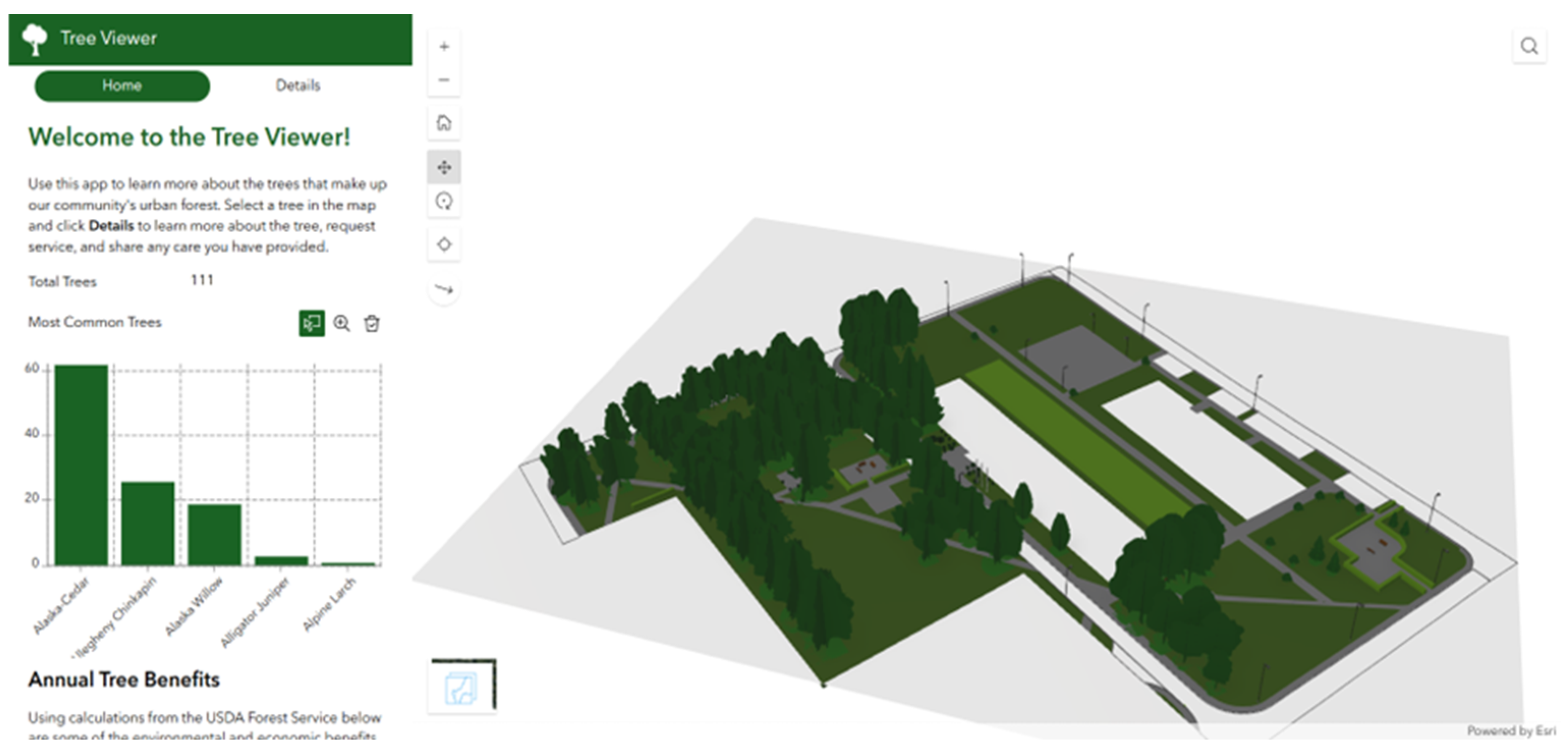
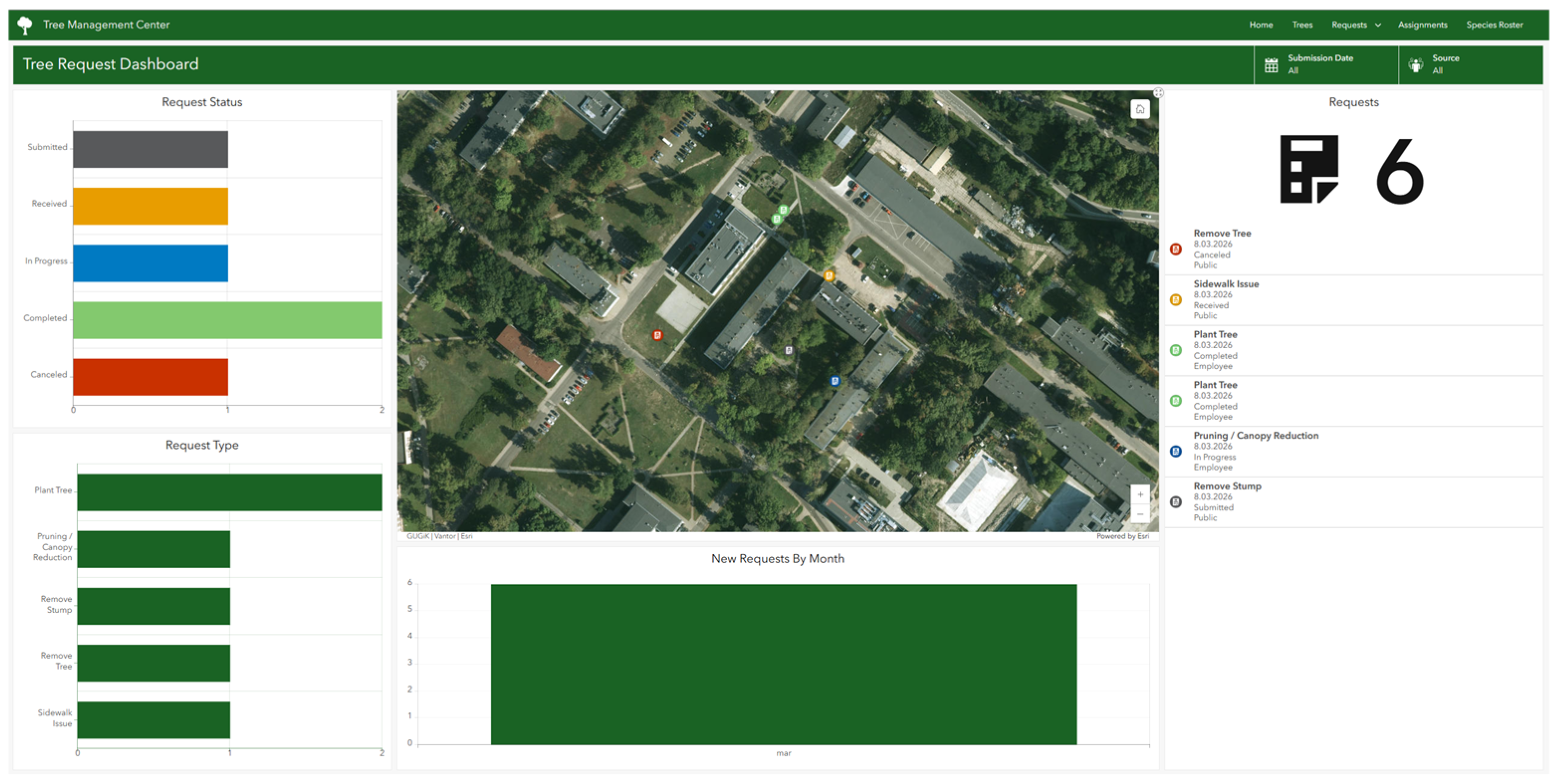
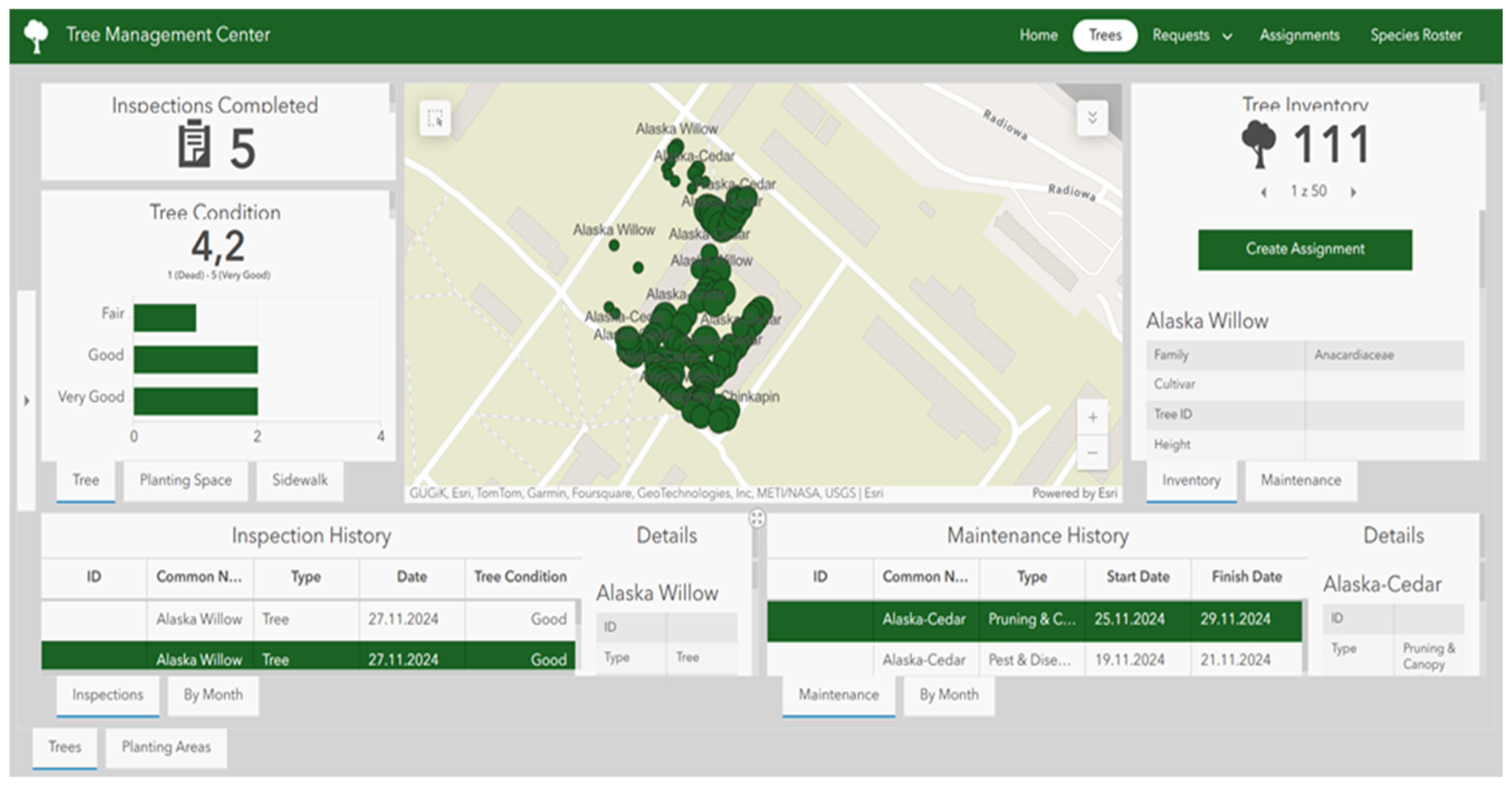
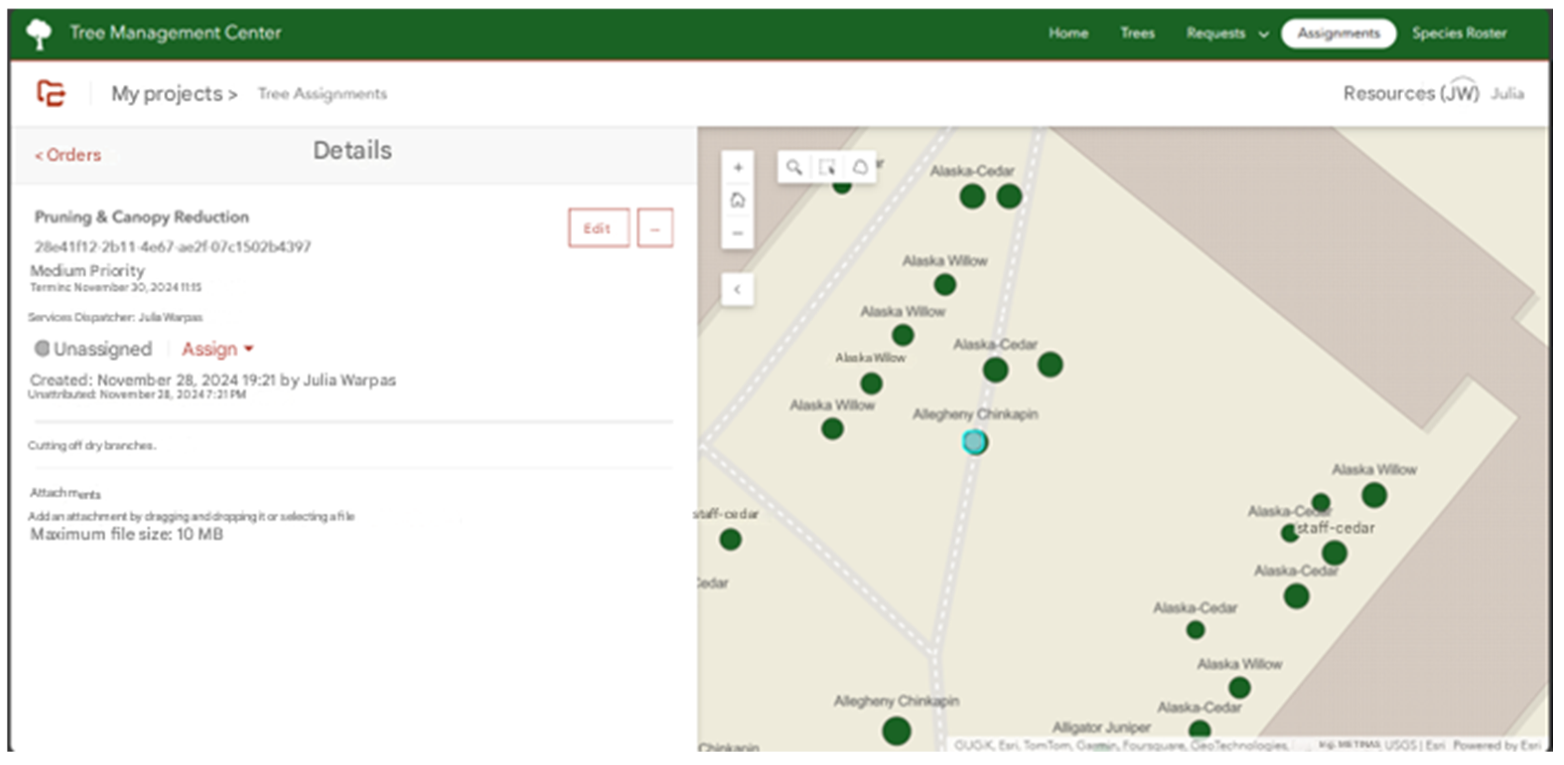
A Case Study on a 7D Landscape Information Model (LIM) for Greenery Maintenance

 , ,
, ,
Abstract
1. Introduction
2. Materials and Methods
2.1. Selection of the Research Site
2.2. Collecting and Creating a Data Structure
2.3. Laser Scanning and Measurement Processing
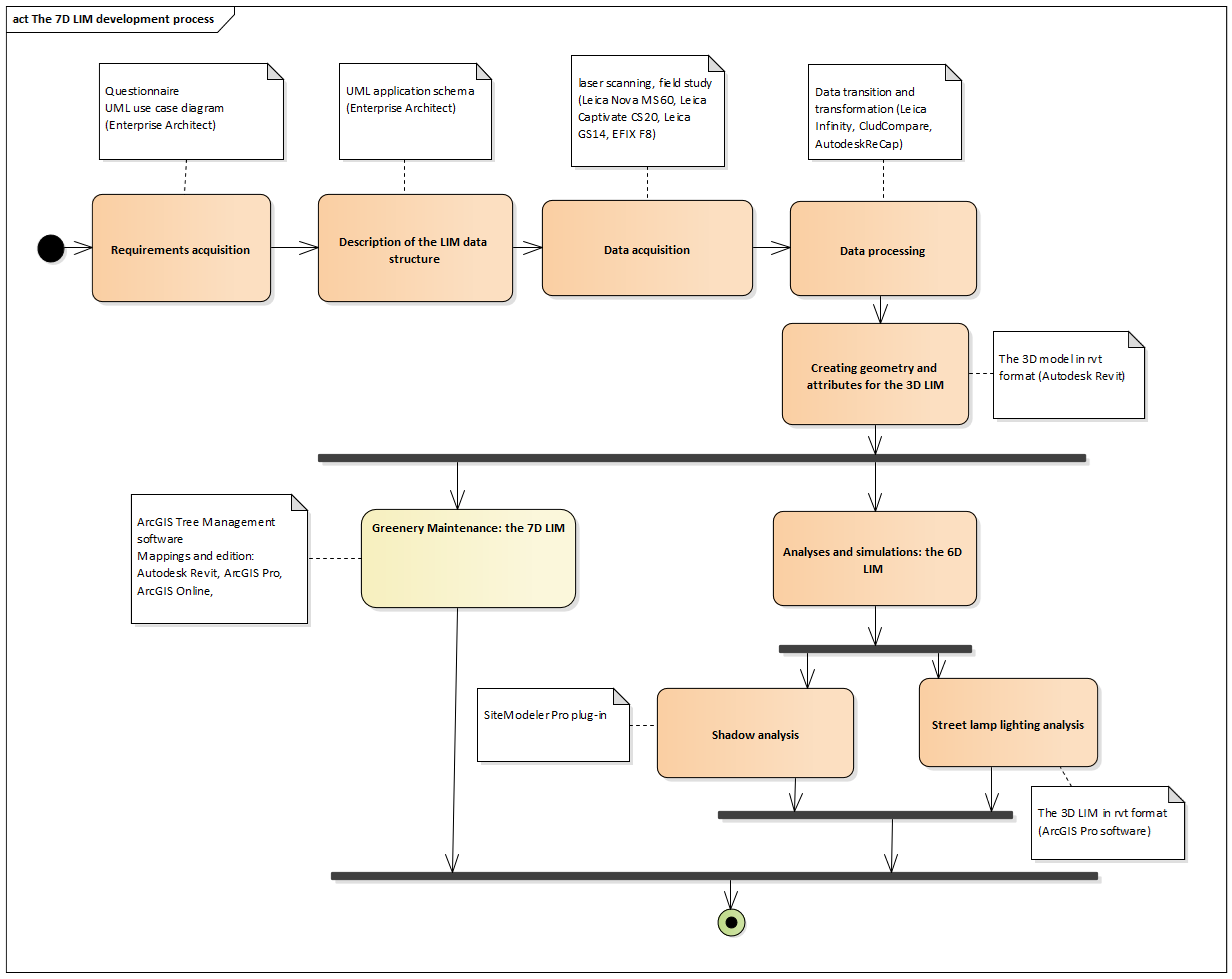
2.4. Development of the 3D LIM
2.5. Development of the 6D LIM
2.6. Development of the 7D LIM
3. Results
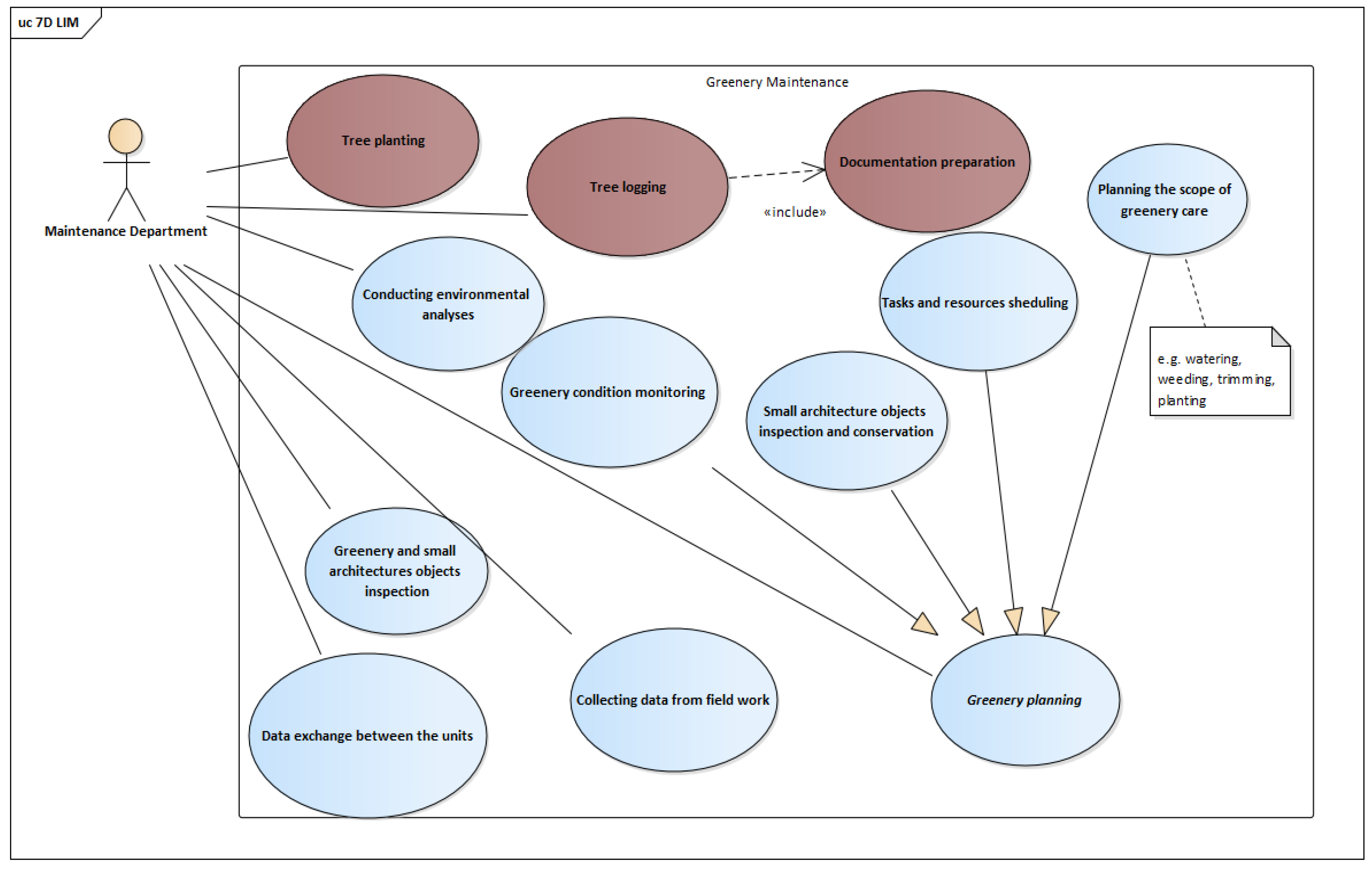
3.1. Requirements Acquisition
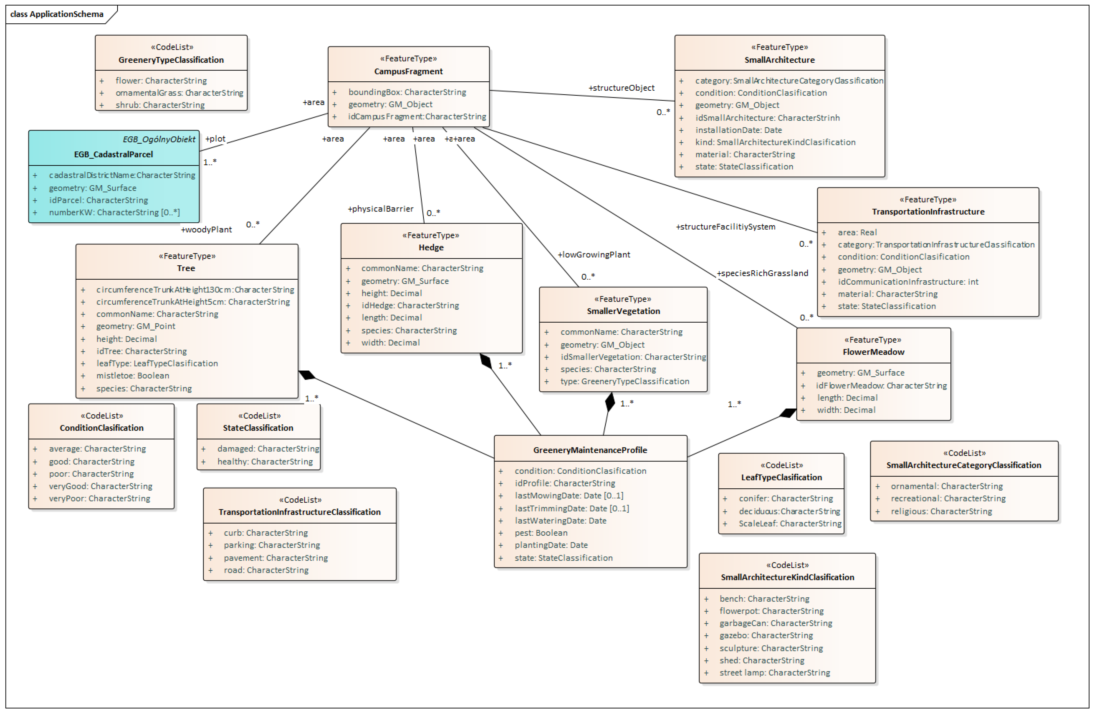
3.2. The UML Model Describing the LIM Data Structure
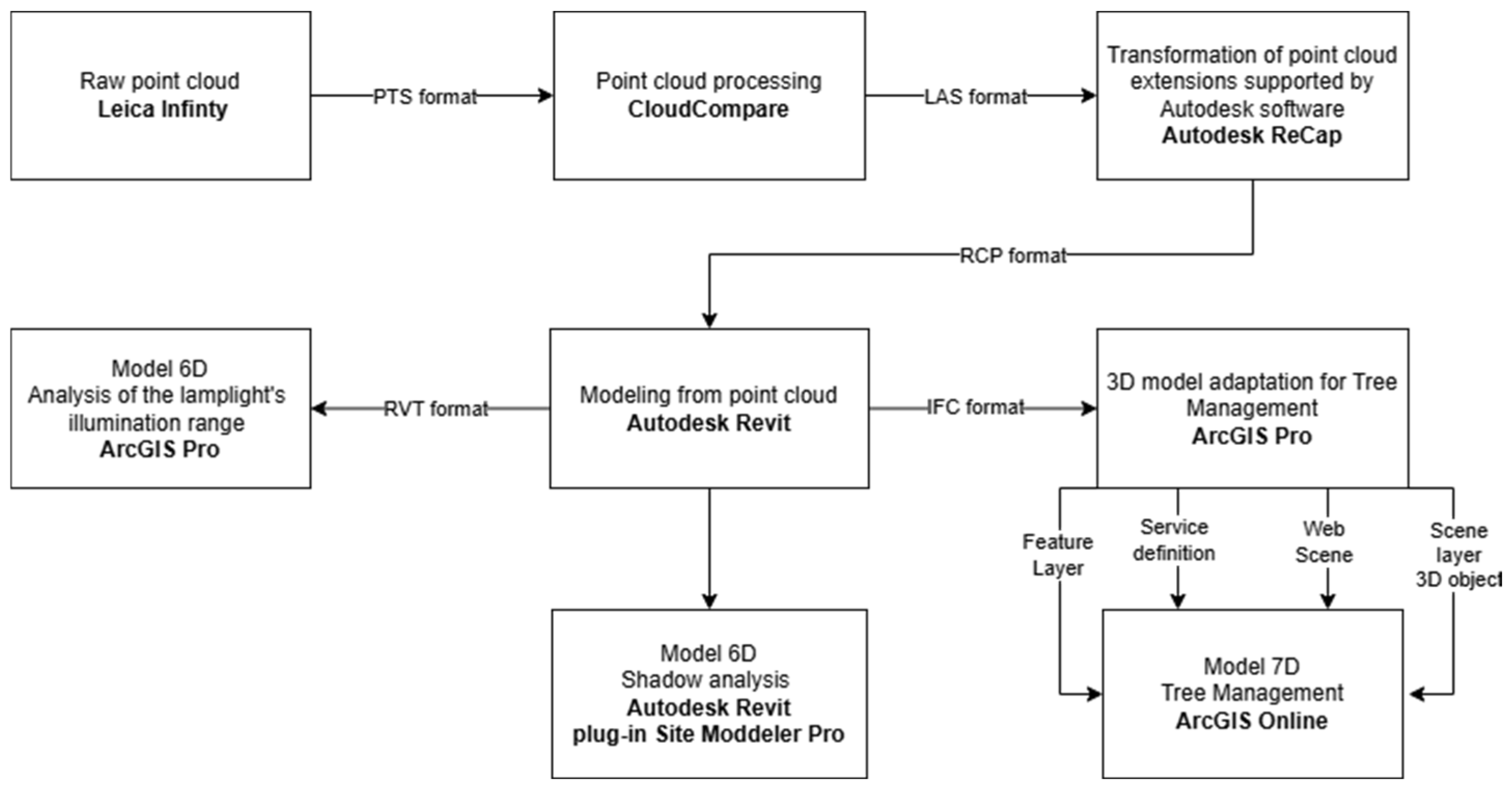
3.3. Data Acquisition and Processing
3.4. The LIM of a Study Area of the Military University of Technology Campus
3.4.1. The 6D LIM
3.4.2. The 7D LIM
4. Discussion
5. Conclusions
Author Contributions
Funding
Institutional Review Board Statement
Informed Consent Statement
Data Availability Statement
Conflicts of Interest
Appendix A

| Feature Type Name | CampusFragment | |
|---|---|---|
| Description | Represents a specific fragment of land within the campus area. | |
| Geometry | GM_Surface | |
| Attributes: | ||
| Name | Data type | Description |
| boundingBox | CharacterString | Represents the spatial boundary of the feature. |
| idCampusFragment | Integer | Unambiguous identification of the feature. |
| Relationships | CampusFragment Hedge SmallerVegetation FlowerMeadow TransportationInfrastructure SmallArchitecture | |
| Feature Type Name | EGB_CadastralParcel | |
|---|---|---|
| Description | Represents an element of the cadastral land division within a fragment of the campus. This class was created based on an interview with the administrative department in order to store information about the cadastral parcel and the cadastral district in which a tree is located. This information is necessary when supplementing applications submitted to administrative authorities. | |
| Geometry | GM_Surface | |
| Attributes: | ||
| Name | Data type | Description |
| cadastralDistrictName | CharacterString | Identification of the administrative unit to which the cadastral parcel is assigned. |
| idParcel | Integer | Unambiguous identification of the feature. |
| numberKW | CharacterString | The number of the feature. |
| Relationships | CampusFragment Tree | |
| Feature Type Name | Tree | |
|---|---|---|
| Description | Represents a single element of tall greenery occurring within the campus area. Attributes such as trunk circumference at specific heights and species were defined based on an interview with the administrative department. This information is necessary when supplementing applications submitted to administrative authorities. | |
| Geometry | GM_Point | |
| Attributes | ||
| Name | Data type | Description |
| species | CharacterString | Allows recording of the tree species. |
| mistletoe | Boolean | Indicates whether mistletoe is present. |
| leafType | LeafTypeClasification | Classification of trees according to leaf type. |
| commonName | CharacterString | Allows recording of the Latin species name. |
| circumferenceTrunkAtHeight130cm | Decimal | Allows recording of the trunk circumference at a height of 130 cm. |
| circumferenceTrunkAtHeight130cm | Decimal | Allows recording of the trunk circumference at a height of 5 cm. |
| idTree | Integer | Unambiguous identification of the feature. |
| height | Decimal | Allows recording of the tree height in meters. |
| Relationships | CampusFragment GreeneryMaintenanceProfile | |
| Feature Type Name | Hedge | |
|---|---|---|
| Description | Represents an element of medium-height greenery, i.e., a hedge. It does not represent a single shrub, but rather the entire linear arrangement of shrubs forming the hedge. | |
| Geometry | GM_Surface | |
| Attributes: | ||
| Name | Data type | Description |
| species | CharacterString | Allows recording of the shrub species from which the hedge is formed. |
| commonName | CharacterString | Allows recording of the Latin species name. |
| length | Decimal | Allows recording of the hedge length in meters. |
| width | Decimal | Allows recording of the hedge width in meters. |
| height | Decimal | Allows recording of the hedge height in meters. |
| idHedge | Integer | Unambiguous identification of the feature. |
| Relationships | CampusFragment GreeneryMaintenanceProfile | |
| Feature Type Name | SmallerVegetation | |
|---|---|---|
| Description | Represents individual elements of low greenery, such as flowers or small shrubs. | |
| Geometry | GM_Object | |
| Attributes | ||
| Name | Data type | Description |
| species | CharacterString | Allows recording of the plant species. |
| commonName | CharacterString | Allows recording of the Latin species name. |
| type | GreeneryTypeClassification | Allows specification of the plant type, e.g., shrub, flower, etc. |
| idSmallerVegetation | Integer | Unambiguous identification of the feature. |
| Relationships | CampusFragment GreeneryMaintenanceProfile | |
| Feature Type Name | FlowerMeadow | |
|---|---|---|
| Description | Represents an area of vegetation composed of diverse species of grasses, herbs, and flowers, often arranged in a natural or designed manner. | |
| Geometry | GM_Surface | |
| Attributes: | ||
| Name | Data type | Description |
| idFlowerMeadow | Integer | Unambiguous identification of the feature. |
| length | Decimal | Allows recording of the meadow length in meters. |
| width | Decimal | Allows recording of the meadow width in meters. |
| Relationships | CampusFragment GreeneryMaintenanceProfile | |
| Feature Type Name | TransportationInfrastructure | |
|---|---|---|
| Description | Represents objects used for movement (e.g., roads, sidewalks), parking areas for vehicles, or elements associated with them (e.g., curbs). | |
| Geometry | GM_Object | |
| Attributes: | ||
| Name | Data type | Description |
| condition | ConditionClasification | Allows assessment of condition. |
| category | TransportationInfrastructureClassification | Allows specification of the type of feature, e.g., road. |
| material | CharacterString | Allows recording of the materials from which the element is made. |
| state | StateClassification | Allows recording of the feature state. |
| area | Decimal | Allows recording of the surface area of the element in . |
| idTransportationInfrastructure | Integer | Unambiguous identification of the feature. |
| Relationships | CampusFragment | |
| Feature Type Name | SmallArchitecture | |
|---|---|---|
| Description | Represents elements of spatial development that are permanent but of small size and serve various functions (e.g., benches, lamps, gazebos). | |
| Geometry | GM_Object | |
| Attributes: | ||
| Name | Data type | Description |
| installationDate | Date | Allows recording of the date when the feature was installed. |
| category | SmallArchitectureCategoryClasification | Allows recording of the feature category, e.g., recreational. |
| condition | ConditionClasification | Allows assessment of feature condition. |
| material | CharacterString | Allows recording of the materials from which the element is made. |
| kind | ObjectTypeClassification | Allows specification of the type of feature, e.g., bench. |
| state | StateClassification | Allows recording of the feature state. |
| idSmallArchitecture | Integer | Unambiguous identification of the feature. |
| Relationships | CampusFragment | |
| Feature Type Name | GreeneryMaintenanceProfile | |
|---|---|---|
| Description | Represents maintenance activities performed on greenery. The class stores information on the dates of planting, mowing, trimming, and watering of plants, as well as data on their condition, state, and the occurrence of pests. When associated with vegetation classes, it enables management and monitoring of greenery elements. | |
| Attributes: | ||
| Name | Data type | Description |
| mowingDate | Date | Allows recording of the date when the plant was mowed. |
| condition | ConditionClasification | Allows assessment of plant condition. |
| pest | Boolean | Allows determination of whether pests occur on the vegetation. |
| plantingDate | Date | Allows recording of the date when the plant was planted. |
| state | StateClassification | Allows recording of the feature state. |
| trimmingDate | Date | Allows recording of the date when the plant was trimmed. |
| wateringDate | Date | Allows recording of the most recent date when the plant was watered. |
| Relationships | Tree Hedge SmallerVegetation FlowerMeadow | |
References
- Zachariasz, A. O architekturze krajobrazu, kompozycji krajobrazu i specjalistycznej terminologii—Rozważania wprowadzające. Pr. Kom. Kraj. Kult. 2016, 32, 11–29. [Google Scholar]
- Bogdanowski, J. Kompozycja i Planowanie w Architekturze Krajobrazu. Zakład Narodowy im Ossolińskich; Wydawnictwo PAN: Wrocław, Poland; Warszawa, Poland; Kraków, Poland; Gdańsk, Poland, 1976; pp. 1–271. [Google Scholar]
- Chmielewski, T.J. Zmierzając ku ogólnej teorii systemów krajobrazowych. Probl. Ekol. Kraj. 2008, 21, 93–110. [Google Scholar]
- Chen, Z.; Yang, H. Research on the Construction Method of Landscape Information Model Based on GIS. In Proceedings of the 2024 4th International Signal Processing, Communications and Engineering Management Conference (ISPCEM), Montreal, QC, Canada, 28–30 November 2024. [Google Scholar] [CrossRef] [Scilit]
- Gnadinger, J.; Roth, G. Applied integration of gis and bim in landscape planning. J. Digit. Landsc. Archit. 2021, 6, 324–331. [Google Scholar]
- Zhao, X.; Li, M.; Sun, Z.; Zhao, Y.; Gai, Y.; Wang, J.; Huang, C.; Yu, L.; Wang, S.; Zhang, M.; et al. Intelligent Construction and Management of Landscapes through Building Information Modeling and Mixed Reality. Appl. Sci. 2022, 12, 7118. [Google Scholar] [CrossRef] [Scilit]
- Gill, A. 3D Landscape Information Model, Using Real-Time 3D Graphics for Site-Based Landscape Design. Ph.D. Thesis, Department of Computer Science, University of Sheffield, Sheffield, UK, 2013. [Google Scholar]
- Li, M.; Liu, S. Research on 3D Courtyard Landscape Modeling Technology Based on Fuzzy Control Algorithm and BIM Technology. In Proceedings of the 2024 Asia-Pacific Conference on Software Engineering, Social Network Analysis and Intelligent Computing (SSAIC), New Delhi, India, 10–12 January 2024. [Google Scholar] [CrossRef] [Scilit]
- Fritsch, M.; Clemen, C.; Kaden, R. 3D landscape objects for building information models (BIM). ISPRS Ann. Photogramm. Remote Sens. Spat. Inf. Sci. 2019, 4, 67–74. [Google Scholar] [CrossRef] [Scilit]
- Borkowski, A.S.; Wyszomirski, M. Landscape Information Modelling: As important aspect of BIM modelling, examples of cubature, infrastructure, and planning projects. Geomat. Landmanag. Landsc. 2021, 1, 7–22. [Google Scholar] [CrossRef] [Scilit]
- Borkowski, A.S.; Kochański, Ł.; Wyszomirski, M. A Case Study on Building Information (BIM) and Land Information (LIM) Models Including Geospatial Data. Geomat. Environ. Eng. 2023, 17, 19–34. [Google Scholar] [CrossRef] [Scilit]
- Zajíčková, V.; Achten, H. Landscape Information Model: Plants as the components for information modelling. In eCAADe 2013: Computation and Performance. Volume 2: Proceedings of the 31st International Conference on Education and Research in Computer Aided Architectural Design in Europe: 18–20 September 2013, Delft, The Netherlands; Stouffs, R., Sariyildiz, S., Eds.; Faculty of Architecture, Delft University of Technology: Delft, The Netherlands, 2013; pp. 515–523. [Google Scholar]
- Wei, W. Research on the Construction of Digital Landscape Information Model Based on BIM Technology. In Proceedings of the Second International Conference on Networks, Multimedia and Information Technology (NMITCON), Bengaluru, India, 9–10 August 2024; IEEE: Piscataway, NJ, USA, 2024. [Google Scholar]
- Mehad, S.E. Toward a suggested proposed model for the use of building information modeling (BIM) in the implementation phase for landscaping. Ain Shams Eng. J. 2022, 13, 101566. [Google Scholar] [CrossRef] [Scilit]
- Döllner, J.; Hagedorn, B. Integrating urban GIS, CAD, and BIM data by service-based virtual 3D city models. In Urban and Regional Data Management; Taylor & Francis Group: London, UK, 2008; pp. 157–170. [Google Scholar]
- Vincenzo Barrile, V.; La Foresta, F.; Calcagno, S.; Genovese, E. Innovative System for BIM/GIS Integration in the Context of Urban Sustainability. Appl. Sci. 2024, 14, 8704. [Google Scholar] [CrossRef] [Scilit]
- Andritsou, D.; Potsiou, C. BIM-GIS Integration for Interactive, Open and Low-Cost 3D Land Use Registration and Urban Neighbourhood Management. Teh. Glas.-Tech. J. 2024, 18, 67–74. [Google Scholar] [CrossRef] [Scilit]
- Jacek, N. Wykorzystanie technologii BIM w procesie eksploatacji budynku. Zesz. Nauk. Politech. Częstochowskiej 2018, 24, 249–254. [Google Scholar]
- Borkowski, A.S. Konstytutywne cechy BIM—Parametryczność, interoperacyjność, wielowymiarowość. Builder 2024, 318, 12–17. [Google Scholar] [CrossRef] [Scilit]
- Ershadi, M.; Jefferies, M.; Davis, P.; Mojtahedi, M. Implementa tion of Building Information Modelling in infrastructure construc tion projects: A study of dimensions and strategies. Int. J. Inf. Syst. Proj. Manag. 2021, 9, 43–59. [Google Scholar]
- Sampaio, A.Z.; Constantino, G.B.; Almeida, N.M. 8D BIM model in urban rehabilitation projects: Enhanced occupational safety for temporary construction works. Appl. Sci. 2022, 12, 10577. [Google Scholar] [CrossRef] [Scilit]
- Jaiswal, S.; Gbadamosi, A.Q.; Olawale, O.; Oluwayemi, B. Ena bling Quality in Lean Construction: Integrating the Principles of Total Quality Management with 9D-BIM. In Proceedings of the International Conference for Sustainable Ecological Engineering Design for Society (SEEDS), Bristol, UK, 31 August–2 September 2022. [Google Scholar]
- ISO 19103:2024; Geographic Information—Conceptual Schema Language. ISO: Geneva, Switzerland, 2024. Available online: https://www.iso.org/obp/ui/en/#iso:std:iso:19103:ed-2:v1:en (accessed on 24 November 2025).
- ISO 19109:2025; Geographic Information—General Feature Model and Rules for Application Schema. ISO: Geneva, Switzerland, 2025. Available online: https://www.iso.org/obp/ui/es/#iso:std:iso:19109:ed-3:v1:en (accessed on 24 November 2025).
- ISO 19107:2019; Geographic Information—Spatial Schema. ISO: Geneva, Switzerland, 2019. Available online: https://www.iso.org/obp/ui/en/#iso:std:iso:19107:ed-2:v1:en (accessed on 24 November 2025).
- Available online: https://smoglab.pl/wp-content/uploads/2024/04/chodnik_smog_warszawapost_WBS.jpg (accessed on 24 November 2025).
- Available online: https://static.kb.pl/media/artykul/45/4568/main-l_l.webp (accessed on 24 November 2025).
- National Geoportal. Available online: https://www.geoportal.gov.pl/ (accessed on 12 December 2025).
- Autodesk App Store. Available online: https://apps.autodesk.com/RVT/pl/Detail/Index?id=1635541306448787441&appLang=en&os=Win64 (accessed on 24 November 2025).
- YouTube. Available online: https://www.youtube.com/watch?v=TWBjbaN5JcQ (accessed on 24 November 2025).
- Available online: https://www.elektriko.pl/jakie-powinno-byc-nowoczesne-oswietlenie-uliczne.html (accessed on 27 November 2025).
- City Hall Website. Available online: https://um.warszawa.pl/ (accessed on 25 November 2025).
- BIMForum. Level of Development Specification, Version 2024, Part I: Public Comment Draft. Available online: https://bimforum.org/wp-content/uploads/2024/11/LOD-Spec-2024-Part-I-public-comment-draft-2024-11-25.pdf (accessed on 25 November 2024).
- Available online: https://bzg.pl/poradnik/artykul/poziomy-rozwoju-modelu-lod/id/11312 (accessed on 29 October 2024).
- Borkowski, A.S.; Łuczkiewicz, N. Landscape Information Model (LIM): A case study of Ołtarzew Park in Ożarów Mazowiecki municipality, Poland. Bud. Archit. 2023, 22, 41–56. [Google Scholar] [CrossRef] [Scilit]
- Kim, M.-K.; Park, D.; Chung, K.-J.; Yun, S.; Park, W.-H.; Lee, D.; Chung, J.-D. Establishment of a Landscape Information Model (LIM) and AI Convergence Plan through the 3D Digital Transformation of Railway Surroundings. Drones 2023, 7, 167. [Google Scholar] [CrossRef] [Scilit]
- Available online: https://www.esri.com/en-us/lg/industry/education/stories/how-mapping-trees-is-helping-to-preserve-institutional-memory-at-the-university-of-north-alabama (accessed on 25 November 2025).
- Cartezan. Available online: https://cartezan.com/products/landscape-information-model/ (accessed on 25 November 2025).
- ArcGIS Solutions. Available online: https://doc.arcgis.com/en/arcgis-solutions/11.2/reference/introduction-to-tree-management.htm (accessed on 22 October 2024).
- Zahrádková, V.; Achten, H. Required Components for Landscape Information Modelling (LIM): A Literature Review. In Peer Reviewed Proceedings of Digital Landscape Architecture 2015 at Anhalt University of Applied Sciences; Buhmann, E., Ervin, S.M., Pietsch, M., Eds.; Herbert Wichmann Verlag, VDE VERLAG GMBH: Berlin/Offenbach, Germany, 2015; ISBN 978-3-87907-555-3. [Google Scholar]
- LAND Research Lab. Available online: https://www.landsrl.com/en/earth-day-land-research-lab-presents-lim-landscape-information-modelling/ (accessed on 5 January 2026).
- GIM 2025. GIM International interviews Ivan Di Federico, CEO, Topcon by Wim van Wegen. GIM Int. 2025, 10–15.
- Pilecki, R. Applications of a Terrestrial Laser Scanner. Tech. J. Crac. Univ. Technol. 2012, 26, 223–233. (In Polish) [Google Scholar]




| Lamp Height [m] | Radius [m] |
|---|---|
| 10.00 | 17.50 |
| 8.00 | 14.00 |
| 6.00 | 10.50 |
Disclaimer/Publisher’s Note: The statements, opinions and data contained in all publications are solely those of the individual author(s) and contributor(s) and not of MDPI and/or the editor(s). MDPI and/or the editor(s) disclaim responsibility for any injury to people or property resulting from any ideas, methods, instructions or products referred to in the content. |
© 2026 by the authors. Licensee MDPI, Basel, Switzerland. This article is an open access article distributed under the terms and conditions of the Creative Commons Attribution (CC BY) license.
Share and Cite
Warpas, J.; Zwirowicz-Rutkowska, A.; Wieczorek, T.; Lisowski, M.; Doskocz, A. A Case Study on a 7D Landscape Information Model (LIM) for Greenery Maintenance. Appl. Sci. 2026, 16, 3067. https://doi.org/10.3390/app16063067
Warpas J, Zwirowicz-Rutkowska A, Wieczorek T, Lisowski M, Doskocz A. A Case Study on a 7D Landscape Information Model (LIM) for Greenery Maintenance. Applied Sciences. 2026; 16(6):3067. https://doi.org/10.3390/app16063067
Chicago/Turabian StyleWarpas, Julia, Agnieszka Zwirowicz-Rutkowska, Tobiasz Wieczorek, Marcin Lisowski, and Adam Doskocz. 2026. "A Case Study on a 7D Landscape Information Model (LIM) for Greenery Maintenance" Applied Sciences 16, no. 6: 3067. https://doi.org/10.3390/app16063067
APA StyleWarpas, J., Zwirowicz-Rutkowska, A., Wieczorek, T., Lisowski, M., & Doskocz, A. (2026). A Case Study on a 7D Landscape Information Model (LIM) for Greenery Maintenance. Applied Sciences, 16(6), 3067. https://doi.org/10.3390/app16063067