Article

Impacts of Holocene Sea Level Rise and the Opening of the Qiongzhou Strait on the Provenance of Sediments in the Beibu Gulf, South China Sea

1
Sanya Geology Institute of South China Sea, Guangzhou Marine Geological Survey, China Geological Survey, Sanya 572025, China
2
Institute for Marine Petroleum Geology, Guangzhou Marine Geological Survey, China Geological Survey, Guangzhou 510075, China
*
Author to whom correspondence should be addressed.
Appl. Sci. 2025, 15(8), 4224; https://doi.org/10.3390/app15084224
Submission received: 11 January 2025 / Revised: 21 March 2025 / Accepted: 3 April 2025 / Published: 11 April 2025
(This article belongs to the Special Issue Recent Advances in Geochemistry)

Abstract

:
The opening of the Qiongzhou Strait during the Holocene was a significant geological event in the Beibu Gulf, profoundly influencing sediment provenance and ocean circulation systems. Due to the scarcity of geological records documenting this event, the understanding of regional Holocene sedimentary evolution has been constrained. To investigate the impact of this event on sediment provenance and ocean currents in the Beibu Gulf, geochemical analyses were conducted on sediment core SO-31 retrieved from the South China Sea. The sediments in core SO-31 were stratigraphically divided into three units based on vertical geochemical profiles, reflecting changes in sea level and shifts in sediment provenance within the study area. The Th/Cr vs. Th/Sc scatter plot for core SO-31 indicate that sedimentary materials primarily originated from the Red River during 11,400–7700 a BP, and a significant change in provenance occurred in the study region around 7700 a BP, characterized by increased contributions from the Qiongzhou Strait and decreased contributions from the Red River. This suggests that the opening of the Qiongzhou Strait significantly influenced the sediment supply to the central Beibu Gulf around 7700 a BP. These findings provide critical geochemical evidence for studying the Qiongzhou Strait opening event and enhance our understanding of Holocene sedimentary evolution and “source–sink” transitions in the Beibu Gulf.

1. Introduction

Marine sediments, serving as carriers of environmental evolution information, are extensively utilized in paleoclimate and paleoenvironmental studies [1,2,3,4,5]. In recent years, the Beibu Gulf, situated in the northwest of the South China Sea, has emerged as a focal area for marine geological research owing to its unique geographical position and topographical conditions [6,7,8,9]. Since the last deglaciation, the Beibu Gulf has undergone significant changes in sedimentary environments due to the continuous rise in global sea levels. Notably, the opening of the Qiongzhou Strait during the early Holocene significantly altered the sedimentary system within the Beibu Gulf [10,11]. To elucidate regional paleoenvironmental and paleoclimatic changes, numerous studies have been conducted on the marine records of the Beibu Gulf, establishing modern sediment source–sink processes and Quaternary paleoclimate evolution based on mineralogical and geochemical analyses of Beibu Gulf sediments [12,13,14,15,16,17]. However, compared to extensive research on modern sediment source–sink processes, studies on sediment provenance transitions since the Holocene remain relatively limited [18,19], particularly concerning significant geological events such as the opening of the Qiongzhou Strait, which have profoundly impacted the source–sink dynamics in this region.
The Qiongzhou Strait, as a critical channel for material exchange between the Beibu Gulf and the eastern sea area, directly influenced the sediment supply and circulation patterns within the Beibu Gulf [20,21]. Previous studies have documented the thick Holocene sediments deposited at the adjacent region of western mouth of the Qiongzhou Strait [22], with contributions from the Qiongzhou Strait also observed in the middle and southern area of the Beibu Gulf [18,19]. Despite its importance, the geological events associated with the opening of the Qiongzhou Strait have not received adequate attention. Consequently, understanding the provenance supply to the Beibu Gulf since the opening of the Qiongzhou Strait remains unclear, and there is a lack of geological evidence effectively reflecting the timing and evolution of this event, which limits our comprehension of Holocene sedimentary evolution and the “source–sink” process. This study provides geochemical characteristics of the sediments based on their major and trace element compositions, deciphering the sedimentary provenance and depositional environment of core SO-31 in the Beibu Gulf, elucidating changes in provenance contributions from the Qiongzhou Strait and other major sediment sources to the central region of the Beibu Gulf. The research findings will provide critical geochemical evidence for a better understanding of the formation and evolution of the Qiongzhou Strait, as well as valuable insights into the paleoenvironmental changes in the Beibu Gulf.

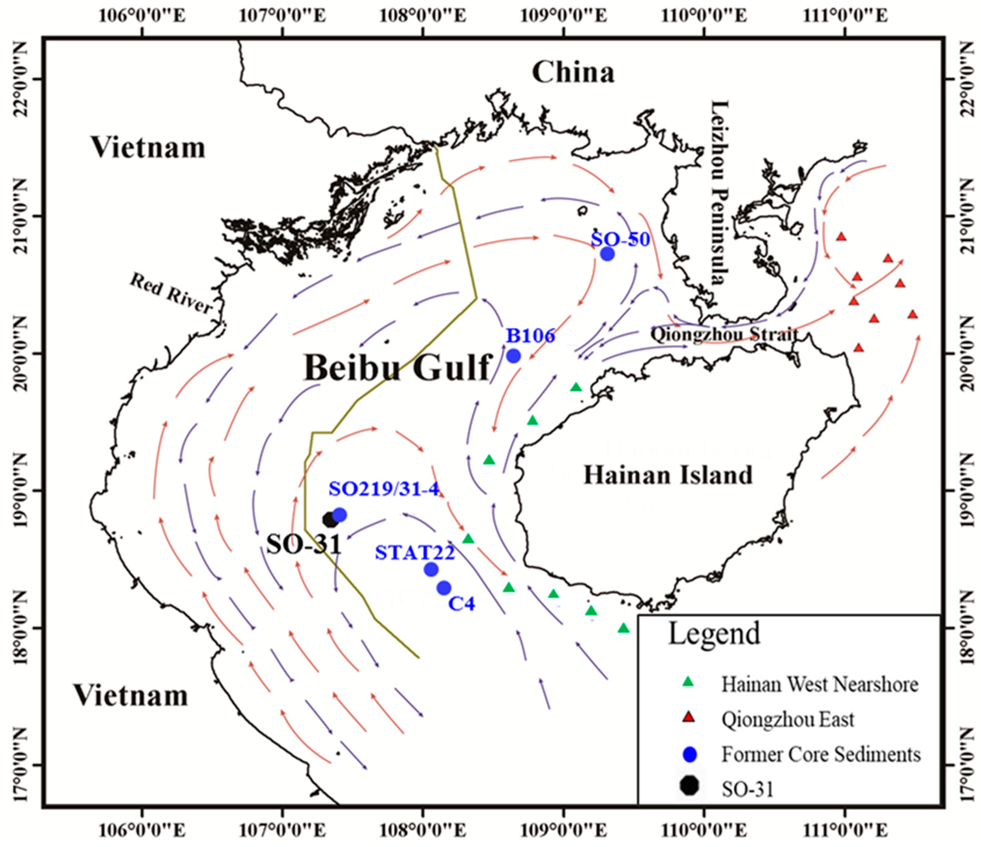
2. Materials and Methods

A gravity core, SO-31, was obtained in the central part of the Beibu Gulf, South China Sea, at coordinates 107°22′19″ E, 18°37′40″ N, by the Chinese–German joint cruise of R/V Sonne 219 in 2011. This sedimentary profile is 738 cm in length and was recovered at a water depth of 75 m. The core site is ~210 km from the Red River mouth in Vietnam and about 150 km from the Changhua River mouth on Hainan Island (Figure 1). The SO-31 core, situated in the central region of the Beibu Gulf, is susceptible to environmental events in its surroundings, which may influence its sedimentary environment and could be recorded in the core sediments. Moreover, no significant depositional discontinuities were observed within the vertical profile of SO-31, suggesting continuous recording of the depositional history since the Holocene epoch. Consequently, this sedimentary column serves as an excellent representative for studying regional sedimentary environmental evolution.
The core was cut into two halves, photographed, described, and then subsampled for grain-size and geochemistry analysis. The core was sampled at 3 cm intervals, and the outer rims of the samples were removed to avoid contamination, yielding a total of 246 samples. Additionally, 16 surface sediment samples were collected from the Qiongzhou east (8 samples) and Hainan west nearshore (8 samples) by box sampler using the China R/V “Fendou 5” in 2012 (Figure 1), and the upper 5 cm of each sample was used for analysis of grain size and elements.
All samples were stored in polyethylene bags and kept frozen at −20 °C until chemical analysis in the laboratory at Guangzhou Marine Geological Survey (GMGS, China). Grain size of the bulk samples was measured by laser particle size analyzer (Mastersizer 2000), after removing organic matter and biogenic carbonate from the samples with 10% H2O2 and 1 N HCl, respectively. Prior to the geochemical analysis, the bulk samples were desalted with distilled water and dried at 60 °C in a clean oven, and then ground to 200 mesh (aperture 0.075 mm) or less in an agate mortar. The 10 major elements (Si, Al, Fe, Mg, Mn, Ca, Na, K, Ti, and P) and 12 trace elements (Sc, V, Cr, Co, Ni, Cu, Zn, Ga, Sr, Ba, Pb, and Zr) were measured by Inductively Coupled Plasma-Optical Emission Spectrometry (ICP-OES, 4300 DV).
To analyze the contents of rare earth elements (REEs), about 100 mg of each sample was first digested by 1 mL 50% HNO3 and 3 mL HF in a tightly closed Teflon vessel on a hotplate at about 160 °C for 48 h. After evaporation to dryness, 1 mL of 55% HClO4 was added to the vessel, which was heated again to about 160 °C until the complete evaporation of the acid. After the sample cooled down to room temperature, 1.5 mL of 50% HNO3 was added, and the sample was again heated at 160 °C for 12 h and then cooled to room temperature. Afterwards, the solution was moved to a measuring cylinder (including the solutions produced by rinsing the vessel with 50% HNO3 to concentrate the remaining sample in the vessel), diluted with 10% HNO3, and measured with an Inductively Coupled Plasma Mass Spectrometer (ICP-MS, X Series 2).
We conducted repeated analysis of several samples and standard sample (GSD-9) analysis to ensure testing accuracy and precision (relative error < 2%). The analysis of grain size and all the elements were done in the Laboratory of Guangzhou Marine Geology Survey (GMGS), Guangzhou, China. The trace elements, including REEs, from the sediments of the Qiongzhou Strait and the Hainan west nearshore were also measured at GMGS using same methods and same accuracy as stated for the SO-31 core sediments.
Nine samples composed of picked foraminifera shells, bivalve shells, and snail fossils were selected for Accelerator Mass Spectrometry (AMS) 14C radiocarbon dating according to the species of shell organisms and depth in the core sediments. When selecting dating samples, bivalves or snail fossils that are easy to find were prioritized. If no bivalves and snail fossils were available at the relevant depth horizon, sediments were collected to select other dating samples like foraminifera shells. This work was completed by the State Key Laboratory of Nuclear Physics and Technology, Peking University, and calibrated with the software Cal. 8.2.0.

3. Results

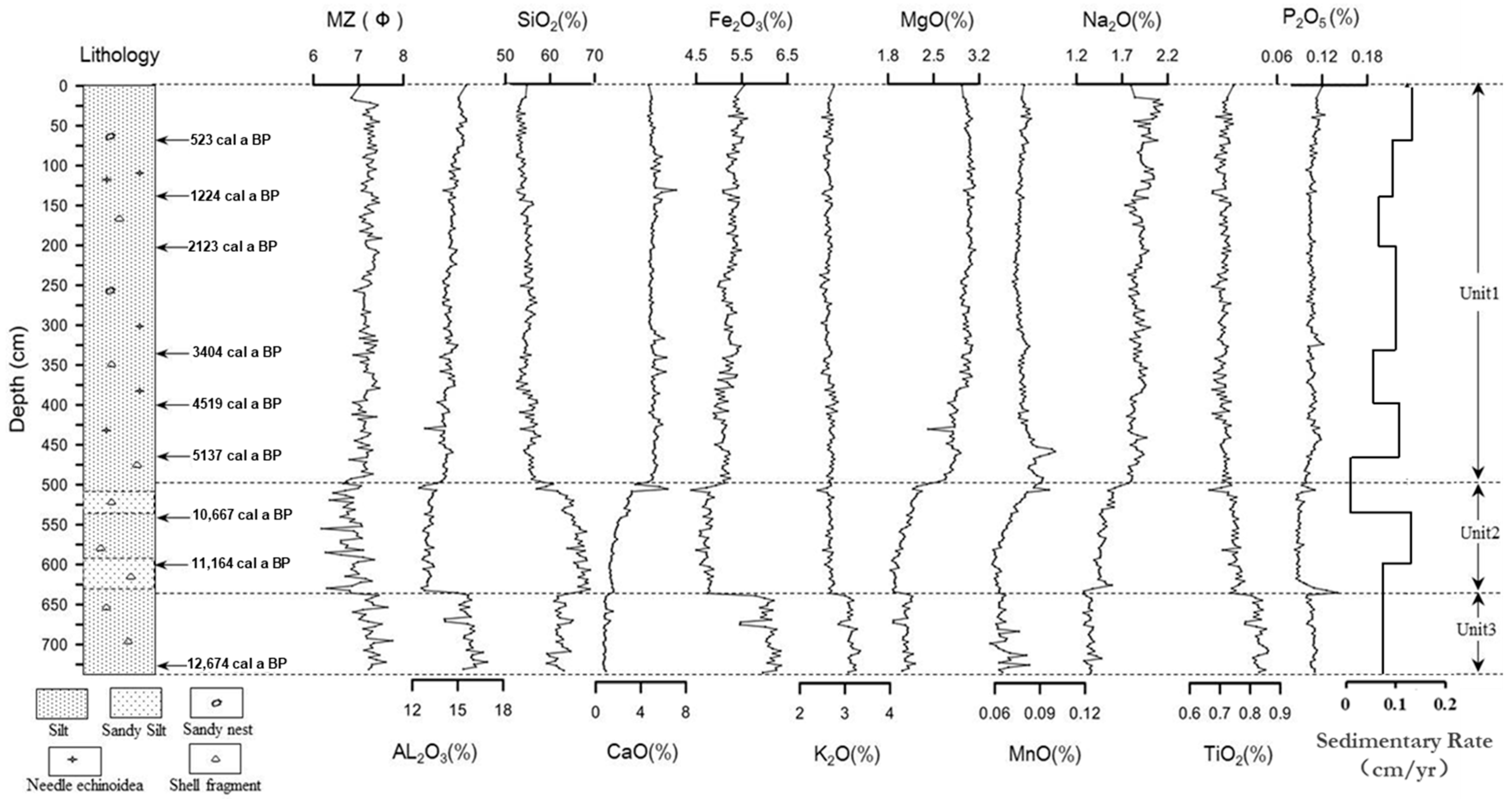
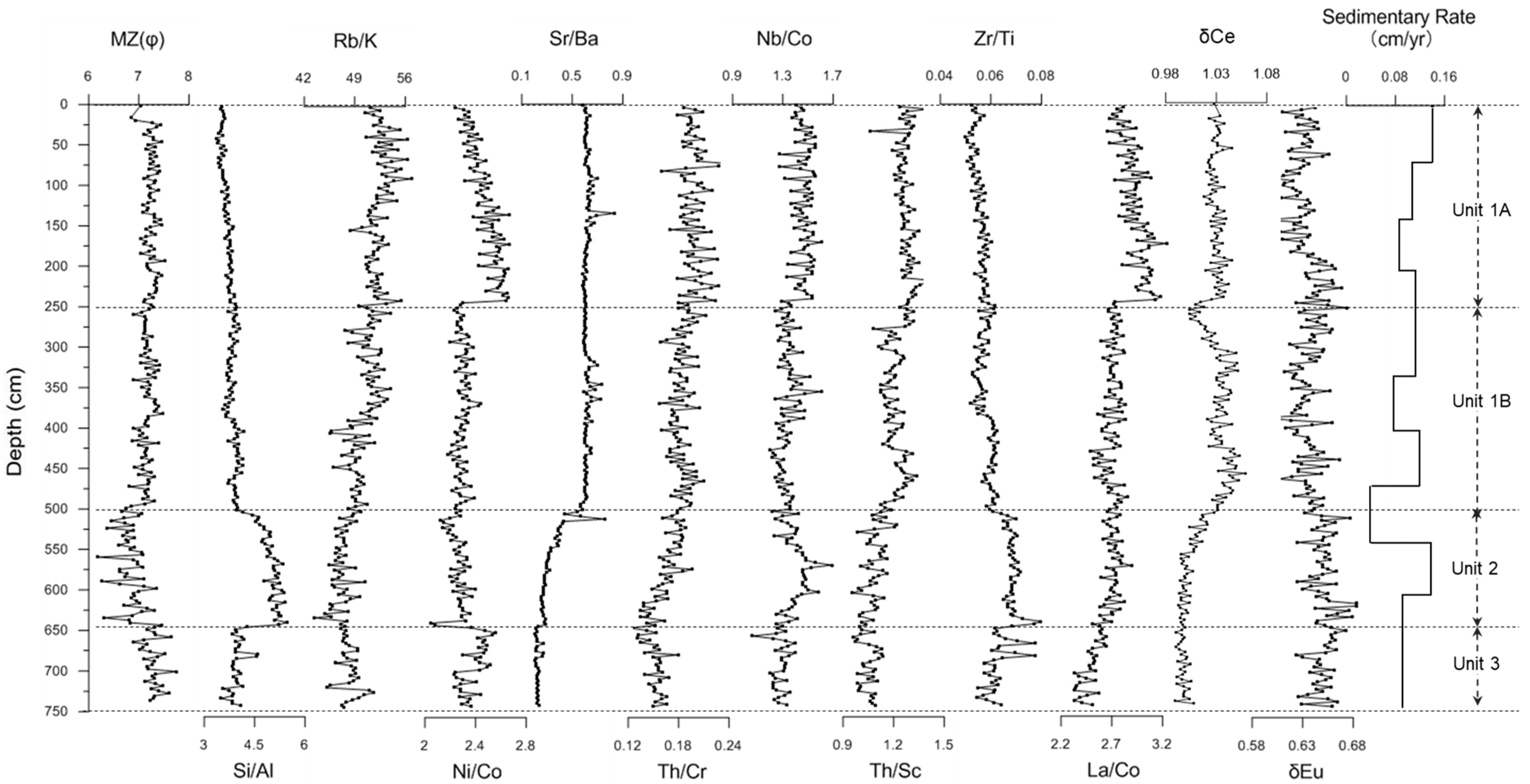
3.1. Chronology Framework and Sedimentary Rates

The chronology for core SO-31 was based on the AMS 14C dating data with a composite age–depth model (Table 1 and Figure 2). The indication of the core had a 2σ basal age of ca. 12,674–13,026 calibrated years before present (cal. yr. BP), which corresponded to a median sedimentation rate of 0.057 cm per year (cm/yr). According to the age–depth model illustrated in Figure 2, the sedimentation rate of this studied core ranged from 0.012 cm/yr to 0.140 cm/yr. Intervals of increased sedimentation accumulation rate (exceeding 0.057 cm/yr) were observed during two periods dated to cal. 12,828–10,667 cal. yr. BP and 5137 cal. yr. BP to the present, whereas the lowest-rate period (below 0.02 cm/yr) occurred ca. 10,667–5137 cal. yr. BP (Figure 2). The sediment dating data of SO-31 are largely consistent with the findings reported by Zhang et al. for SO219/31-4 [13], likely due to the proximity of the two sites (less than 500 m apart). Minor discrepancies of datasets between the SO-31 and SO219/31-4 can be attributed to variations in the specific locations and depths of the sampled sediments.

3.2. Characteristics of Major and Trace Elements

The major and trace element compositions, together with the mean grain size (MZ), for the core sediments are given in Table 2 and Table 3. The mean grain size ranges from 6.18Φ to 7.76Φ, with the average of 7.14Φ, showing that silt-sized or finer grains dominate the core sediments, and the study area had a relatively calm sedimentary environment. Among the major elements measured for the entire profile, SiO2 is a dominant component, averaging 57.72% in the sediment, followed by Al2O3, averaging 14.43%. The two elements amount to an average of more than 70%, indicating that the sediment is dominated by silicate and aluminosilicate. The CaO content is also relatively high, with an average of 4.0%, which is slightly lower than the average of the coastal area of the Hainan Island [23,24], but far higher than the sediment content of the Red River [25,26,27], indicating that bicarbonate deposition is relatively active in this area. Content The content of Al2O3 was slightly higher than the average of shallow sea sediments [18], but lower than that of the Red River [25,26,27], which may be related to the dilution of biocalcinous detritus in the study area, which may be due to the quiet mode of sedimentation. The contents of Fe2O3, K2O, MgO, Na2O, TiO2, P2O5, and MnO in the sediments of SO-31 are close to the average values of the sediments from the shallow sea of the South China Sea, and the contents of most trace elements such as Co, Cu, Ni, Zn, V, Ba, Sc, Ga, Pb, Cr, and La in the core sediments are slightly higher than the average of the shallow area of the South China Sea [18], which may be caused by the difference in the sedimentary environment and material sources between the Beibu Gulf and other areas in the South China Sea. In general, geochemical composition similar to that of the upper crust (UCC) [28] indicates that the surrounding continent is the main source of sediments in this area.
The SO-31 core sediments can be divided into 3 sedimentary units: Unit 1, Unit 2, and Unit 3, in ascending order, according to the vertical variation in grain size and geochemistry (Figure 2 and Figure 3). In Unit 1 (0–501 cm, 0–7700 a BP), the content of SiO2 in sediments showed a gradual increase with depth; conversely, the contents of Al2O3, Fe2O3, and Na2O showed a trend of decreasing with depth. At 501 cm depth, an obvious change in the contents of most of major elements (such as SiO2, Al2O3, Fe2O3, P2O5, MgO, CaO, and Na2O) and trace elements (such as Zn, Cu, Gd, and Sr) can be observed simultaneously. In Unit 2 (501–640 cm, 7700–11,600 a BP), SiO2 content is slightly higher than the average, and the contents of K2O and TiO2 are close to that of the average. In Unit 3 (640–738 cm, 11,600–12,800 a BP), compared with Unit 2, the contents of SiO2 in Unit 3 decreased rapidly, and conversely, the contents of Al2O3, Fe2O3, K2O, TiO2, Co, Cu, Ni, Zn, V, Sc, Ga, Pb, Cr, and Zr increased significantly. Similarly to the major and trace elements, the rare earth elements (REEs and LREEs/HREEs) and the grain size of the core sediments also show similar variation in the vertical direction. The abrupt changes at depths of 501 cm and 640 cm indicate that the sedimentary environment has undergone significant changes.

4. Discussion

4.1. Potential Sources of the Sediments

The Beibu Gulf is a semi-closed gulf located northwest of the SCS and connected with the SCS through the southern end of the gulf and Qiongzhou Strait, which is located between Hainan Island and the Leizhou Peninsula (Figure 1). The Red River (Song Hong River) provides the major riverine discharge into the gulf, along with some smaller coastal rivers [29,30]. Discharge from the Pearl River, about 400 km to the northeast, may reach the gulf through Qiongzhou Strait [31]. Additionally, coastal erosion also is a significant source of sediments; amounts of suspended particulate matter (SPM) from the west area of Hainan Island can even be transported to the center of the Beibu Gulf [18]. Geologically, Cambrian to recent strata are outcropped in the land area around the Beibu Gulf. The granitic rocks, as the dominant rocks, occupy more than 60% of the area west of Hainan Island [32]; the basic igneous rocks of the Tertiary and Quaternary periods compose the basement of the Leizhou Peninsula; and Paleozoic sandstone and shale are widely exposed in the coastal areas of the Guangxi province, People’s Republic of China [33]. In most of the Beibu Gulf surrounding land areas, the solid rocks are unevenly mantled by Quaternary alluvium, regolith, or deeply weathered rocks [33]. The Red River drainage system has considerable differences in its lithologies, including metamorphic rocks, limestone, granitoid rocks, felsic rocks, and ultramafic rocks [25]. The sediments derived from these different rocks are intensively mixed within the Red River estuary. The variation in rock types surrounding the Beibu Gulf inevitably resulted in differences in material composition and geochemical characteristics across these source areas, and this variability offers a valuable opportunity to trace and identify the different origins of sedimentary materials in the study area.

4.2. Identification of the Sediment Provenance

Previous studies have revealed that REEs, La, Sc, Ti, Co, Hf, Th, and Nb are especially useful for monitoring source-area composition [34,35,36,37,38]. In order to further study the sediment provenance, element ratios of Si/Al, Rb/K, Zr/Ti, Th/Sc, La/Co, δCe, and so on were selected for identification of sediment sources of SO-31 (Figure 4), given that the ratios of these elements can better offset the grain size and carbonate dilution effect. Additionally, these elements show distinct differences during magmatic differentiation and can be more effective in discriminating their provenance [39,40]. It is evident from Figure 4 that the vertical distribution of element ratios aligns well with the distribution of individual element contents (Figure 2 and Figure 3). Notably, at a depth of 250 cm, significant variations are observed in indicators such as Ni/Co, Th/Sc, Th/Cr, and δCe. These changes further subdivide Unit 1 into two sub-units, namely, Unit 1A and Unit 1B, reflecting a substantial alteration in sediment sources within this region.
Th/Sc and Th/Cr are commonly utilized as indicators for differentiating sediment sources [41,42]. Tong (2007) demonstrated that Th/Cr and Th/Sc effectively distinguish sediments originating from the Pearl River, Red River, and Mekong River, which are the primary input rivers around the Beibu Gulf [25]. In the study area, Th/Sc and Th/Cr also exhibit marked differences among the three main source end-members: the Red River, the eastern part of the Qiongzhou Strait, and the western part of Hainan Island. Furthermore, the vertical variations in Th/Sc and Th/Cr correspond well with the unit division of SO-31, confirming their utility as effective indicators for analyzing sediment sources of SO-31. The scatter plots of ratios of Th/Sc and Th/Cr show that the three sedimentary units had different distribution characteristics. The scatter plots in Unit 1 (including Unit 1A and Unit 1B) had a similar distance with that of the Red River, the west nearshore of the Hainan Island, and the east side of the Qiongzhou Strait, indicating that the three possible source areas may have similar contributions to the sediments in the sea area. Compared with Unit 1, the scatter plots in Unit 2 moved gradually away from the east side of the Qiongzhou Strait and coastal sediments of the Hainan Island, but closer to the Red River, indicating the increasing contributions of the Red River runoff. Unit 3 is closer to the Red River than Unit 2 and Unit 1, which indicates that the Red River was the main source area for the core sediments in this unit.
The provenance analysis results of the SO-31 sediments differ from the STAT22 sediments reported by Cui (2016) [18]. Geographically, the core STAT22 is situated on the eastern slope of the Beibu Gulf (Figure 1), and its sediments are predominantly influenced by sources from the western part of Hainan Island. Due to the “central depression” topography of the Beibu Gulf, sediments from the western part of the gulf, including those from the Red River, are less likely to be transported to the STAT22 location under the influence of the bottom current. In contrast, SO-31 is located in the central area of the Beibu Gulf, where materials from the surrounding area of the Beibu Gulf, including the Red River and the western part of the Beibu Gulf, can more easily reach this location. Therefore, the sediments at SO-31 provide a more comprehensive record of the provenance changes in the Gulf. In addition, it should also be noted that the scatter plot of Th/Sc vs. Th/Cr (Figure 5) shows that the sediments from the three units in SO-31 are not completely located among the Red River, the western nearshore of Hainan Island, and the eastern Qiongzhou Strait end-member, suggesting the presence of other significant sediment sources influencing this region, especially the western coastal area of the Beibu Gulf.

4.3. Depositional Sedimentation History and Environmental Changes

During the Holocene, with the regional sea level rise associated with climate change, the Beibu Gulf experienced a series of drastic environmental changes. Especially, the Qiongzhou Strait opening event at the end of the Early Holocene [43,44] had a great impact on the hydrodynamic environment and material input of the Beibu Gulf [45,46].
At the beginning of the Holocene (12,800~11,600 a BP), the Beibu Gulf was in the period of relatively low sea level, and the regional sea level was ~60 m lower than in the present [47,48]. During a comparable period (12,900–11,700 a BP), Zhang et al. discovered intermittent occurrences of diatoms mainly composed of typical coastal species and nearshore planktonic species in the adjacent columnar sediment SO219/31-4, suggesting that it was in a fluvial or shallow-water sedimentary environment [13], this is consistent with the low Sr/Ba ratio (<0.25) found in the Unit 3 sediments in the present study. In the period, the Red River, being the largest river discharging into the Beibu Gulf, significantly influenced sedimentation in the region. It extensively incised the continental shelf, extending its channel southward even to the study area [49,50,51,52], potentially allowing direct accumulation of Red River sediments on the mid-outer shelf. Additionally, smaller rivers such as the Changhua, Ma, and Nanliu Rivers also contributed to regional sediment sources, though the Red River remained the predominant contributor. In contrast, the eastern side of the Qiongzhou Strait did not serve as a major sediment source during this period due to the strait’s closure [43,44].
Between 11,600–7700 a BP, the location of SO-31 progressively moved farther from the Red River outlet and surrounding terrestrial areas as regional sea levels rose, which is supported by the reduced abundance of shell remains and CaO, alongside an increase in Sr/Ba ratios in Unit 2 sediments compared to those in Unit 3. This stage corresponds to stage 2 and stage 3 (11,700–9500 a BP and 9500–7200 a BP) as defined by Zhang et al. based on diatom assemblages. Unfortunately, this only illustrated the lowest sedimentation rate observed in the 9500–7200 stage and was attributed to the slowing of sea level rise, while the overall low sedimentation rate in the two stages failed to provide a detailed explanation [13]. Throughout this interval, the Red River continued to dominate sediment supply to the study area (Figure 5). Previous studies indicate that sea levels in the Beibu Gulf were rising rapidly in this period [53,54], and as sea levels increased, sediment deposition gradually shifted away from river mouths, including the Red River and other coastal rivers, leading to a decrease in sediment input and overall sedimentation rates in the region. Notably, at the end of Unit 2 (depth of 501 cm), there was a marked change in sedimentation rates and provenance, suggesting the potential west-to-east connection of the Qiongzhou Strait. Previous studies have shown that during the 11,600–7700 a BP period, the sea level in the Beibu Gulf was still rising rapidly. With the continuous rise in sea level, the sediment area gradually moved away from the estuary area of the Red River and other rivers entering the sea, and the provenance input of the Red River and other rivers entering the sea decreased, resulting in the overall decrease in the sedimentation rate in the area. It is worth noting that at the end of this unit (501 cm, 7700 a BP), there was a significant change in deposition rate and provenance in the area, which may indicate that the Qiongzhou Strait had been connected from east to west. With a significant influx of sediments from the eastern part of the Qiongzhou Strait into the Beibu Gulf, these materials were subsequently transported to the study area by ocean currents. Consequently, the contribution rate of the Red River to the provenance of the area was diminished, leading to a relative reduction in the Red River’s influence on the regional provenance (Figure 5). Collectively, these observations suggest that the Qiongzhou Strait likely opened around 7700 a BP; this is consistent with Zhao et al. and Yao et al.’s assumptions [43,44].
From 7700–0 a BP, sediments originating from the eastern Qiongzhou Strait became one of the primary contributors to the core area sediments, as indicated by the proximity of Unit 1 sediments to Qiongzhou East sediments in Th/Sc vs. Th/Cr plots (Figure 5). Unit 1 sediments are positioned centrally among the three provenance end-members (the Red River, the western Hainan Island, and the eastern Qiongzhou Strait), indicating a mixed sedimentary product derived from all three sources (Figure 5); this aligns with previous interpretations by Dou (2012) and Cui (2015) [55,56]. Compared to Unit 1B, the scatter plot of Unit 1A (2800–0 a BP) in Th/Sc vs. Th/Cr shows closer affinity to the western Hainan Island and Qiongzhou Strait. This stage also corresponds to stages 4–8 (7200–0 a BP), as defined by Zhang et al. However, their focus was primarily on the increase in the sedimentation rate during Stage 6, which they attributed to sea-level drop and abnormal hydrodynamic conditions, while the reasons for the overall increase in the sedimentation rate across stages 4–8 remain unaddressed [13]. According to Shi (2007) [57], sea levels in the Beibu Gulf exhibited a downward trend during this period (2800–0 a BP). The continuous decline in sea level facilitated greater sediment transport to the study area, enhancing local sedimentation rates. Meanwhile, the Qiongzhou Strait channel underwent progressive incision and widening due to tidal currents, increasing sediment input from the east into the Beibu Gulf and, correspondingly, elevating sediment contribution rates in the region.
Several prevailing perspectives exist regarding the formation and evolution of the Qiongzhou Strait, particularly concerning its opening time during the Holocene. Zhao et al. conducted a comprehensive analysis of regional geological, geophysical, and paleontological data, concluding that the east–west waterway of the Qiongzhou Strait formed between 10.5 and 7.1 ka BP [43]. Yao et al., based on relative sea level change curves and sediment thickness data from the northwest South China Sea, determined that the east–west waterway of Qiongzhou Strait primarily developed between 11.0 and 8.5 ka BP, with full penetration occurring at approximately 8.5 ka BP [44]. Chen et al., using grain size analysis and AMS 14C dating of core sediments from both sides of the strait, estimated the penetration time of the Strait to be around 8.0 ka BP [11]. In this study, the significant increase in provenance contribution from Qiongzhou Strait, observed at 7.7 ka BP in core SO-31, aligns well with the aforementioned conclusion despite minor temporal discrepancies. These results further corroborate that the Qiongzhou Strait opened in the early Holocene, approximately 8.0–7.7 ka BP. Additionally, Xu et al. also observed a significant increase in deposition rates at the C4 and B106 core sediment stations in the eastern Beibu Gulf around 7.0 ka BP [20], whereas no such notable increase was observed in the SO-31 sediments; this discrepancy suggests that the increased deposition rates in the two stations should not be attributed to the opening events of the Qiongzhou Strait.

5. Conclusions

(1) The changes in provenance and sedimentary environment within the Beibu Gulf of the South China Sea were primarily driven by regional sea level rise during the Holocene. Additionally, the opening of the Qiongzhou Strait in the early Holocene had a significant impact on the provenance supply to the Beibu Gulf.
(2) Sediments in core SO-31 were stratigraphically divided into three units based on vertical variations in the abundance of major and trace elements, reflecting fluctuations in sea level and shifts in sediment provenance within the study area.
(3) The Th/Cr vs. Th/Sc scatter plot for sediments from core SO-31 indicates that the contribution from the Qiongzhou Strait increased markedly around 7700 a BP, suggesting that the opening event of the Qiongzhou Strait occurred during this period and significantly influenced the source supply to the Beibu Gulf.
(4) The Th/Cr vs. Th/Sc scatter plot shows that sediments from core SO-31 do not fully fall between the three source end elements. This suggests potential biases in identifying major provenance areas in the region. Therefore, additional provenance areas should be considered, especially the western coast of the Beibu Gulf.

Author Contributions

Z.C.: conceptualization, methodology, validation, formal analysis, investigation, data curation, writing—original draft preparation. Y.H.: software, visualization, writing—review and editing. All authors have read and agreed to the published version of the manuscript.

Funding

This research was funded by both geological survey projects of the China Geological Survey (1212010914027, DD20221725, DD20230404, DD20240090) and BMBF in Germany (03F0607A).

Institutional Review Board Statement

Not applicable.

Informed Consent Statement

Not applicable.

Data Availability Statement

The raw data supporting the conclusions of this article will be made available by the authors on request.

Conflicts of Interest

The authors declare no conflicts of interest.

References

  1. Sobrino, M.C.; Parada, C.A.; Cartelle, V.; Carreño, N.M.; Delgado, C.; Cazás, N.; Lázaro, I.; Gil, S.G. Sediment recycling during the Holocene marine transgression in Ría de Vigo (NW Iberia): Multiproxy evidence and environmental implications. Quaternary Sci. Rev. 2024, 344, 109006. [Google Scholar] [CrossRef]
  2. Limoges, A.; Ribeiro, S.; Nieuwenhove, N.V.; Jackson, R.; Juggins, S.; Crosta, X.; Weckström, K. Marine diatoms record Late Holocene regime shifts in the Pikialasorsuaq ecosystem. Global Change Biol. 2023, 23, 6503–6516. [Google Scholar] [CrossRef] [PubMed]
  3. Razjigaeva, N.G.; Ganzey, L.A.; Grebennikova, T.A.; Mokhova, L.M.; Degterev, A.V.; Ezhkin, A.K.; Rybin, A.V.; Arslanov, K.A.; Maksimov, F.E.; Petrov, A. The Records of Environmental Changes in Lacustrine-Swamp Sequences within the Mountain Area of Iturup Island since the Late Glacial Period. Russ. J. Pac. Geol. 2022, 16, 116–130. [Google Scholar] [CrossRef]
  4. Peterson, D.C.; Phipps, B.J. Accommodation space controls on incised-valley sediment accumulation rates during the Holocene marine transgression (0–11ka) in Grays Harbor, a large meso-tidal estuary, Washington, USA. Mar. Geol. 2016, 38, 1–16. [Google Scholar] [CrossRef]
  5. Thong, G.T.; Watitemsu, I.; Temsulemba, W. Geochemical evidences on the origin and paleo-oceanic depositional setting of the Naga Hills Ophiolite cherts, North East India. Geol. J. 2022, 57, 3114–3134. [Google Scholar] [CrossRef]
  6. Andreas, G.; Jan, H. Relative sea-level changes induced by glacial isostatic adjustment and sediment loads in the Beibu Gulf, South China Sea. Oceanologia 2023, 65, 249–259. [Google Scholar]
  7. Van, N.S.; Van, N.K.; Viet, B.D.; Duy, C.T. Biostratigraphy and palaeoenvironments of early Pleistocene deposits in the southern part of the Gulf of Tonkin, Vietnam. Quatern Int. 2021, 604, 1–15. [Google Scholar]
  8. Liu, F.; Zhang, R.; Li, H.; Liu, H.; Yan, A.; Han, M.; Yu, K. Distribution and adsorption-desorption of organophosphate esters from land to sea in the sediments of the Beibu Gulf, South China Sea: Impact of seagoing river input. Stoten 2024, 917, 170359. [Google Scholar] [CrossRef]
  9. Xu, G.; Liang, D.; Jia, L.; Xiao, Y.; Wen, L.; Sang, M.; Li, S.; Chen, B.; Fu, C.; Du, J.; et al. Early-Middle Holocene beach rocks at the western Qiongzhou Strait and their significance for paleo-sea level reconstruction. Acta Geol. Sin. 2023, 97, 2386–2398. [Google Scholar]
  10. Xu, D.; Ge, Q.; Han, X.; Deng, T.; Xiao, T. Driving force of marine sedimentary source to sink; A case study from Beibu Gulf. J. Mar. Sci. 2022, 40, 17–32. (In Chinese) [Google Scholar]
  11. Chen, L.; Zhang, Y.; Li, T.; Yang, W.; Chen, J. Sedimentary Environment and Its Evolution of Qiongzhou Strait and Nearby Seas since Last Ten Thousand Years. J. Earth Sci. China 2014, 39, 696–704. [Google Scholar]
  12. Liang, D.Y.; Wu, S.Z.; Xu, G.Q.; Xia, C.J.; Gao, F.L.; Lin, Y.H.; Jia, L.Y. Paleoenvironmental changes in the coastal zone of the northwest South China Sea during the last 13 kyr. Sci. Rep. 2023, 13, 13540. [Google Scholar] [CrossRef]
  13. Zhang, J.P.; Michal, T.; Andrzej, W.; Xia, Z.; Li, C. A fossil diatom-based reconstruction of sea-level changes for the Late Pleistocene and Holocene period in the NW South China Sea. Oceanologia 2023, 65, 211–229. [Google Scholar] [CrossRef]
  14. Liang, D.; Xu, G.; Gao, F.; Wen, L.; Jia, L.; Liu, L.; Jiao, D.; Yang, C.; Wu, S. Holocene sediment source analysis and paleoclimatic significance of core KZK01 from the eastern part of the Beibu Gulf. Front. Earth Sci. 2023, 11, 1192206. [Google Scholar] [CrossRef]
  15. Li, Y.; Fan, T.; Wang, A.; Zeng, J.; Lv, Y.; Zhang, M.; Liu, D. The Sediments in the Beibu Gulf Reveal Dramatic Paleoenvironmental Changes and Climate Events over the Past 20,000 Years. J. Mar. Sci. Eng. 2024, 12, 615. [Google Scholar] [CrossRef]
  16. Guan, Y.; Chen, Y.; Sun, X.; Xu, L.; Xu, D.; Zhu, Z.; He, W. The Clay Mineralogy and Geochemistry of Sediments in the Beibu Gulf, South China Sea: A Record of the Holocene Sedimentary Environmental Change. J. Mar. Sci. Eng. 2023, 11, 1463. [Google Scholar] [CrossRef]
  17. Li, M.; Ouyang, T.; Roberts, P.A.; Heslop, D.; Zhu, Z.; Zhao, X.; Qiu, Y. Influence of Sea Level Change and Centennial East Asian Monsoon Variations on Northern South China Sea Sediments Over the Past 36 kyr. Geochem. Geophys. Geosyst. 2018, 19, 1674–1689. [Google Scholar]
  18. Cui, Z.; Schulz-Bull, E.; Hou, Y.; Xia, Z.; Waniek, J. Geochemical Characteristics and Provenance of Holocene Sediments (Core STAT22) in the Beibu Gulf, South China Sea. J. Coastal Res. 2016, 32, 1105–1115. [Google Scholar] [CrossRef]
  19. Zhang, A.; Chen, M.; Gan, H.; Chen, Q.; Lan, B.; Fang, Q. Geochemical characteristics and sediment provenance of Core SO-50 sediments in the Beibu Gulf. Hai Yang Xue Bao 2018, 10, 107–117. (In Chinese) [Google Scholar]
  20. Xu, D.; Li, J.; Chu, F.; Long, J.; Ye, L.; Han, X. The Response of Sedimentary Records in Eastern BeibuGulf to the Last Postglacial Transgression and Circulation. Earth Sci. J. China Univ. Geosci. 2013, 38 (Suppl. S1), 70–82. [Google Scholar]
  21. Chen, B.; Shi, M. Advances in Study of Beibu Gulf Circulation. Guangxi Sci. 2019, 26, 595–603. (In Chinese) [Google Scholar]
  22. Ni, Y.; Endler, R.; Xia, Z.; Endler, M.; Harff, J.; Gan, H.; Schulz-Bull, D.; Waniek, J. The butterfly delta system of Qiongzhou Strait: Morphology, seismic stratigraphy and sedimentation. Mar. Geol. 2014, 355, 361–368. [Google Scholar] [CrossRef]
  23. Xu, D.; Long, J.P.; Qian, J. The modern sedimentation rate and the distribution character of 7 cores in Hainan Island offshore. J. Mar. Sci. 2008, 26, 9–17. (In Chinese) [Google Scholar]
  24. Cui, Z.; Lin, J.; Gan, H.; Liu, W.; Zhang, L. Geochemical characteristics of the surface sediments in the eastern Beibu Gulf, South China Sea. Mar. Sci. 2015, 39, 103–111. (In Chinese) [Google Scholar]
  25. Tong, S. Element Geochemistry for Surface Sediments of Pearl, Red and Mekong Rivers. Master’s Thesis, Tongji University, Shanghai, China, 2007. (In Chinese). [Google Scholar]
  26. Tong, S.; Liu, Z.; PhonLe, K.; Huang, W. Chemical Weathering in the Red River Basin: Records of Major and Trace Elemental Geochemistry. Bull. Mineral. Petrol. Geochem. 2006, 3, 218–225. (In Chinese) [Google Scholar]
  27. Taylor, S.; Mclennan, S. The Continental Crust: Its Composition and Evolution: An Examination of the Geochemical Record Preserved in Sedimentary Rocks; Blackwell Scientific Publications: Oxford, UK, 1985; p. 312. [Google Scholar]
  28. Wetzela, A.; Unverricht, D. Sediment dynamics of estuarine Holocene incised-valley fill deposits recorded by Siphonichnus (ancient Red River, Gulf of Tonkin). Palaeogeogr. Palaeocl. 2020, 560, 110041. [Google Scholar] [CrossRef]
  29. Hori, K.; Tanabe, S.; Saito, Y.; Haruyama, S.; Nguyen, V.; Kitamura, A. Delta initiation and Holocene sea-level change: Example from the Song Hong (Red River) delta, Vietnam. Sediment Geol. 2004, 164, 237–249. [Google Scholar] [CrossRef]
  30. Wei, L.; Wang, C.; Cui, H.; Jia, J.; Zeng, L.; Su, M. Provenance of sediments in the northern shelf of the South China Sea: Insights from Pb isotopes in detrital K-feldspar. Mar. Geol. 2025, 480, 107448. [Google Scholar] [CrossRef]
  31. Zhao, J.; Zhang, L.; Wang, X.; Ge, J.; Xu, M.; Chen, W.; Luo, M.; Liang, Q.; Yu, Q.; Luo, S.; et al. Characteristics of Paleontological Communities in Surface Sediments of the Southern South China Sea and Their Paleoclimatic and Paleoenvironmental Significance. J. Earth Sci. 2024, 35, 144–154. [Google Scholar] [CrossRef]
  32. Xu, D. The Research of Sedimentary Geochemistry of the Hainan Island Nearshore Sea Area. Master’s Thesis, The Second Institute of Oceanography, Hangzhou, China, 2007. (In Chinese). [Google Scholar]
  33. Feng, W.K.; Xue, W.J.; Yang, D.Y. The Geological Environment of Late Quaternary in the Northern South China Sea; Guangdong Science and Technology Publishing House: Guangzhou, China, 1988; p. 261. (In Chinese) [Google Scholar]
  34. Hu, M.; Zhu, Y.; Chen, W.; Yu, B.; Zhang, P.; Hu, C.; Jin, R. Investigating the Element Geochemical Behavior and Provenance of Surface Sediments in the Offshore Area of Sierra Leone, Africa: Insights from Major and Trace Elements. Water 2024, 23, 3540. [Google Scholar] [CrossRef]
  35. Paola, G.; Bartolomeo, S.; Federica, B.; Chiara, P.; Beatrice, M.; Roberta, S.; Enzo, G.; Matteo, P.; Alessandro, L.; David, C. Sources and trends of trace elements and polycyclic aromatic hydrocarbons in a shallow lake in the Mediterranean area from sediment archives of the Anthropocene. Environ. Sci. Pollut. Res. 2022, 29, 85815–85828. [Google Scholar]
  36. Ahmad, Z.; Singh, P. REE geochemistry of core sediments of Cauvery delta, India for provenance studies. Acta Geochim. 2020, 39, 512–526. [Google Scholar] [CrossRef]
  37. Jung, H.; Lim, D.; Jeong, D.; Xu, Z.; Li, T. Discrimination of sediment provenance in the Yellow Sea: Secondary grain-size effect and REE proxy. J. Asian Earth Sci. 2016, 123, 78–84. [Google Scholar] [CrossRef]
  38. Lim, D.J.; Hoi, S.; Choi, J.Y. REE partitioning in riverine sediments around the Yellow Sea and its importance in shelf sediment provenance. Mar. Geol. 2014, 357, 12–24. [Google Scholar] [CrossRef]
  39. Brijraj, K.; AL-Mikhlafi, A.; Kaura, P. Geochemistry of Mansar Lake sediments, Jammu, India: Implication for source-area weathering, provenance, and tectonic setting. J. Asian Earth Sci. 2006, 26, 649–668. [Google Scholar]
  40. Wronkiewicz, D.J.; Condie, K.C. Geochemistry of Archean shales from the Witwatersrand Supergroup, South Africa: Source-area weathering and provenance. Geochim. Cosmochim. Acta 1987, 51, 2401–2416. [Google Scholar] [CrossRef]
  41. Guo, Y.; Li, C.; Wang, C.; Xu, J.; Jin, C.; Yang, S. Sediment Routing and Anthropogenic Impact in the Huanghe River Catchment, China: An Investigation Using Nd Isotopes of River Sediments. Water Resour. Res. 2021, 57, e2020WR028444. [Google Scholar] [CrossRef]
  42. Li, Q.; Liu, S.; Han, B.; Wang, Y.; Dang, Q. Geochemical characteristics of the metapelites from the Xingxingxia group in the Eastern Segment of the Central Tianshan: Implications for the provenance and paleoweathering. Sci. China Ser. D Earth Sci. 2005, 48, 1637–1648. [Google Scholar] [CrossRef]
  43. Zhao, H.; Wang, L.; Yuan, J. Origin and time of Qiongzhou Strait. Mar. Geol. Quat. Geol. 2007, 27, 33–40. (In Chinese) [Google Scholar]
  44. Yao, Y.; Harff, J.; Meyer, M.; Zhan, W. Reconstruction of paleocoastlines for the northwestern South China Sea since the Last Glacial Maximum. Sci. China Earth Sci. 2009, 52, 1127–1136. [Google Scholar] [CrossRef]
  45. Shi, M.; Chen, C.; Xu, Q.; Lin, H.; Liu, G.; Wnag, H.; Wang, F.; Yan, J. The Role of Qiongzhou Strait in the Seasonal Variation of the South China Sea Circulation. circulation. J. Phys. Oceanogr. 2002, 32, 103–121. (In Chinese) [Google Scholar] [CrossRef]
  46. Tang, D.; Kawamura, H.; Lee, M.A.; Dien, T.V. Seasonal and spatial distribution of chlorophyll-α concentrations and water conditions in the Gulf of Tonkin, South China Sea. Remote Sens. Environ. 2003, 85, 475–483. [Google Scholar] [CrossRef]
  47. Zhao, H.; Liu, Z.; Zhao, Y. Sea level and East Asian monsoon influenced chemical weathering records in the southern South China Sea over the past 21 ka. Global Planet. Change 2024, 232, 104324. [Google Scholar] [CrossRef]
  48. Thanakorn, J.; Liu, Z. East Asian monsoon and sea-level controls on clay mineral variations in the southern South China Sea since the Last Glacial Maximum. Quatern Int. 2021, 592, 1–11. [Google Scholar]
  49. Yang, H.; Qiao, L.; Liu, X. Shoreline evolution of the Red River Delta in the recent 30 years. Mar. Geol. Quanternary Geol. 2020, 40, 48–57. (In Chinese) [Google Scholar]
  50. Yu, Y.; Mu, Y. The new institutional arrangements for fisheries management in Beibu Gulf. Mar. Policy 2006, 30, 249–260. [Google Scholar] [CrossRef]
  51. Borges, J.; Huh, Y. Petrography and chemistry of the bed sediments of the Red River in China and Vietnam: Provenance and chemical weathering. Sediment. Geol. 2007, 194, 155–168. [Google Scholar] [CrossRef]
  52. Zhou, G.; Cao, X.; Xia, J.; Wang, S.; Song, Z. A dramatic marine environment change in the Beibu Gulf of the South China Sea around 3.2 kyr BP. Lithosphere 2022, 2022(Special 9), 2632112. [Google Scholar]
  53. Tanabe, S.; Hori, K.; Saito, Y.; Haruyama, S.; Vu, V.P.; Kitamura, A. Song Hong (Red River) delta evolution related to millennium-scale Holocene sea-level changes. Quatern. Sci. Rev. 2003, 22, 2345–2361. [Google Scholar] [CrossRef]
  54. Hanebuth, T.J.J.; Voris, H.K.; Yokoyama, Y.; Saito, Y.; Okuno, J. Formation and fate of sedimentary depocentres on South- east Asia’s Sunda Shelf over the past sea-level cycle and biogeographic implications. Earth Sci. Rev. 2011, 104, 92–110. [Google Scholar] [CrossRef]
  55. Dou, Y.; Li, J.; Li, Y. Rare earth element compositions and provenance implication of surface sediments in the eastern Beibu Gulf. Geochimica 2012, 41, 147–157. (In Chinese) [Google Scholar]
  56. Cui, Z.; Gan, H.; Liu, W.; Zhang, L. Geochemical characteristics of major elements and provenance implication of surface sediments in the eastern Beibu gulf. Comput. Tech. Geophys. Geochem. Explor. 2015, 37, 522–531. (In Chinese) [Google Scholar]
  57. Shi, X.; Yu, K.; Chen, G. Progress in researches on sea level changes in South China Sea since Mid-Holocene. Mar. Geol. Quat. Geol. 2007, 27, 121–132. [Google Scholar]
Figure 1. Geographical setting of the Beibu Gulf and location of the gravity core SO-31. The black triangles and black dots show the surficial sediments from Qiongzhou east and Hainan west nearshore, respectively. The yellow line indicates the boundary between Vietnam and The People’s Republic of China. The arrows indicate the main current direction for the SW (red color)/NE (blue color) monsoon.
Applsci 15 04224 g001
Figure 2. Geological column and down-core variations in mean grain size (MZ) and major elements of the core SO-31 sediments show the change in the sedimentary environment. Dashed horizontal lines indicate the boundaries between depositional units (Unit 1, Unit 2, and Unit 3). The nine ages marked with arrows in geologic column were obtained by the AMS 14C dating.
Applsci 15 04224 g002
Figure 3. Down-core variations of trace elements and rare earth elements of the core SO-31 sediments show the change in the sedimentary environment. Dashed horizontal lines indicate the boundaries between depositional units (Unit 1, Unit 2, and Unit 3).
Applsci 15 04224 g003
Figure 4. Down-core variations of selected indexes of the core SO-31 sediments show the changes in the source and the environment. Dashed horizontal lines indicate the boundaries between depositional units.
Applsci 15 04224 g004
Figure 5. Discrimination plot of Th/Cr vs. Th/Sc for SO-31 core sediments.
Applsci 15 04224 g005
Table 1. AMS 14C dates from the SO-31 sediment core.
No.Depth (cm)SourceConventional 14C Age, YearCal. Year BP (2σ)
173Bivalve shell940 ± 30382–655
2142Spiral Shell1680 ± 301060–1366
3205Bivalve shell2460 ± 301939–2307
4337Foraminifera3510 ± 303217–3580
5403Bivalve shell4370 ± 304320–4736
6469Foraminifera4860 ± 304912–5318
7538Bivalve shell9710 ± 4010,442–10,937
8601Bivalve shell10,060 ± 5010,908–11,389
9733Foraminifera11,350 ± 5012,674–13,026
Table 2. Concentrations of major (%) and trace (10−6) elements and mean grain size (Φ) in SO-31 sediments and the surficial sediments; n is the sample number.
MZSiO2Al2O3Fe2O3CaOMgOK2ONa2OMnOP2O5TiO2CoNiCrSrZrScVGaBaRbNbTh
All samples
(n = 246)
Min6.1851.812.44.350.681.842.391.280.060.080.6712.329.569.090.513911.081.716.633311810.011.6
Max7.7669.016.96.367.123.143.342.140.100.140.8619.445.010930325615.911922.845416024.617.5
Mean7.1457.714.45.264.002.682.711.740.080.100.7314.734.685.119317812.992.819.238513620.215.3
Unit 1
(n = 171)
Min6.6651.812.44.353.202.192.391.550.070.090.6712.329.570.916313911.681.716.733312617.213.6
Max7.5161.715.65.617.123.142.842.140.100.120.7415.935.810530319214.798.121.342714723.317.5
Mean7.1854.814.55.235.132.952.641.890.080.110.7114.233.683.322916512.890.019.337213619.815.9
Unit 2
(n = 43)
Min6.1862.212.64.501.121.842.521.280.060.080.7113.630.569.095.419411.082.816.638111810.011.6
Max7.3569.015.05.803.182.253.001.610.080.140.8116.639.310716824313.310619.742114123.014.8
Mean6.8366.013.14.761.862.022.681.470.070.090.7514.332.581.312421012.388.617.440212619.713.3
Unit 3
(n = 32)
Min6.8859.314.15.460.681.882.861.280.060.100.7816.038.881.990.518212.810219.241013718.013.4
Max7.7665.116.96.361.512.213.341.470.080.110.8619.445.010911925615.911922.845416024.616.6
Mean7.2962.115.76.080.862.083.131.350.070.110.8317.942.599.998.521014.511321.543615122.815.2
Qiongzhou East (n = 8)Min6.1255.310.94.461.801.662.031.090.070.100.6210.724.351.111116511.56613.22658415.213.3
Max7.2268.716.56.376.462.232.441.880.090.150.9715.936.281.024126014.011021.234814223.138.4
Mean6.8460.613.75.273.391.982.281.580.080.120.7913.229.971.715220512.68517.332711820.225.5
Hainan West Nearshore
(n = 8)
Min4.5054.37.952.733.021.471.970.950.060.080.506.8814.936174739.0408.9128410412.411.1
Max7.6469.317.06.1110.62.502.712.010.080.130.8815.435.38846934013.810121.537016521.623.1
Mean6.1660.112.14.725.631.972.311.460.070.100.6511.625.56526320611.47015.230713016.917.4
Red River (mean) 15.5244.211.611.29.8911.41.683.030.180.812.265.05-21.123.516.815.1128-56414725.318.0
UCC 26.0061.715.06.175.393.672.583.180.090.170.6710.020.035.035019011.060.017.05501122510.5
1 Data from Tong et al., 2007 [25]; 2 Data from Taylor et al., 1985 [28].
Table 3. Concentrations of REEs (10−6) and REE characteristic parameters in SO-31 sediments and the surficial sediments; n is the sample number.
LaCePrNdSmEuGdTbDyHoErTmYbLuREEsLREE 3/HREE 4δCe 5δEu 6
All samples
(n = 246)
Min36.672.88.2930.35.591.094.840.754.460.842.340.362.320.36172.88.50.920.59
Max46.792.110.639.27.671.496.661.036.891.203.440.543.440.56221.09.80.980.68
Mean40.281.29.1233.56.291.225.490.845.080.952.720.422.660.42190.19.30.950.64
Unit 1
(n = 171)
Min36.674.68.2930.35.591.094.960.754.460.842.340.362.360.36173.79.10.930.59
Max41.985.49.4634.86.831.275.770.905.421.012.880.452.820.44197.69.80.980.67
Mean39.781.19.0133.16.171.195.410.824.960.922.650.412.600.40188.49.40.960.63
Unit 2
(n = 43)
Min36.772.88.4230.85.761.144.840.774.610.882.380.372.320.36173.08.80.920.62
Max42.984.89.7735.46.821.365.950.895.561.082.940.472.940.45201.39.50.950.68
Mean38.876.98.7932.56.111.205.300.814.880.932.580.402.540.39182.19.20.930.65
Unit 3
(n = 32)
Min40.881.09.4035.06.781.275.700.905.561.042.970.462.900.45194.48.50.920.62
Max46.792.110.639.27.671.496.661.036.891.203.440.543.440.56221.08.90.930.67
Mean44.487.810.137.47.131.406.220.975.991.133.230.503.170.50210.18.70.920.65
Qiongzhou East
(n = 8)
Min33.770.67.6929.45.431.084.660.744.210.772.170.322.000.31173.08.50.880.62
Max46.295.310.539.77.471.546.161.006.061.163.360.513.050.49163.39.01.120.68
Mean39.582.59.1133.86.481.285.490.855.070.942.740.412.570.40222.69.71.050.66
Hainan West Nearshore
(n = 8)
Min25.258.25.8321.63.810.733.370.482.790.501.600.251.460.27191.29.40.960.60
Max47.297.910.939.77.441.416.210.975.851.083.230.493.180.53126.18.71.060.65
Mean40.682.69.1733.546.251.215.480.854.970.912.740.422.690.43225.510.71.030.63
Red River (mean) 152.0311211.543.37.731.677.991.035.671.093.150.432.850.40250.510.11.070.65
UCC 236.973.88.0130.15.581.114.860.784.550.862.430.392.530.39172.39.31.100.65
1 Data from Tong et al., 2007 [25]; 2 Data from Taylor et al., 1985 [28]; 3 LREE = La + Ce + Pr + Nd + Sm + Eu; 4 HREE = Gd + Tb + Dy + Ho + Er + Tm + Yb + Lu; 5 δCe = 2CeN/(LaN + PrN); 6 δEu = 2EuN/(SmN + GdN); CeN, LaN, PrN, EuN, SmN, and GdN are the normalized values of chondrites measured for the corresponding elements.
Disclaimer/Publisher’s Note: The statements, opinions and data contained in all publications are solely those of the individual author(s) and contributor(s) and not of MDPI and/or the editor(s). MDPI and/or the editor(s) disclaim responsibility for any injury to people or property resulting from any ideas, methods, instructions or products referred to in the content.

