Abstract
Seismic sedimentology and sequence stratigraphy, as emerging interdisciplinary fields, demonstrate unique advantages in characterizing seismic geomorphological responses of various system tracts within the stratigraphic frameworks of rift lacustrine basins. Focusing on the Paleogene Dainan Formation in the Gaoyou Sag of the Subei Basin, eastern China, this study integrates seismic termination patterns, sedimentary cyclicity analysis, and well-to-seismic calibration to subdivide the formation into three third-order sequences containing lowstand (LST), transgressive (TST), and highstand (HST) system tracts. The distribution of five distinct sedimentary facies exhibits pronounced sub-tectonic zonations controlled by the basin’s architecture and structural evolution, with steep slope zones dominated by nearshore subaqueous fan–fan delta complexes, gentle slopes developing normal deltaic systems, and deep-semi-deep lacustrine facies with slump turbidite fans concentrated in depositional centers. Through a novel application of 90° phase adjustment, spectral decomposition, and multi-attribute fusion techniques, the relationship between seismic amplitude attributes and lithologies are established via seismic lithology calibration. Detailed sequence evolution analyses and seismic geomorphological interpretation systematically elucidate the spatio-temporal evolution of depositional systems within different system tracts in rift lacustrine basins, providing a novel methodological framework for sequence stratigraphic analysis in continental rift settings.
1. Introduction
Sequence stratigraphy is a geological discipline which systematically investigates the influence of base-level fluctuations on sedimentary responses, the genetic mechanisms of basin filling, and the internal architectural configurations of sedimentary basins. Central to this field is the analysis of dynamic interactions between accommodation space and sedimentary processes, which have driven innovative advancements in the classification of stratigraphic units, the spatio-temporal distribution patterns of depositional systems, and predictive modeling of sedimentary mineral resources. Distinguished by its interdisciplinary nature and strong scientific predictability, the discipline has achieved widespread recognition in both academic research and the hydrocarbon exploration industries through its rigorous integration of diverse datasets [1,2,3,4,5,6].
Seismic sedimentology extends sequence stratigraphic principles by emphasizing seismic termination patterns and attribute analysis in chronostratigraphic interpretation, creating synergistic linkages between seismic stratigraphy and traditional sequence stratigraphic methods. This discipline capitalizes on the lateral continuity of 3D seismic data to extract high-resolution geomorphic signatures that directly inform depositional environmental reconstructions. Its two operational branches, seismic lithology and seismic geomorphology, serve complementary functions; the former converts seismic volumes into lithofacies distribution models while the latter translates geomorphic units into depositional systems through morphological diagnostics. The methodological toolkit integrates 90° phase rotation or shift, stratal slicing, frequency decomposition, RGB attribute blending, and geomorphic interpretation to quantitatively delineate the evolution of system tracts [7,8,9,10,11,12].
With the continuous improvement of resolution in 3D seismic imaging, modern seismic exploration has achieved enhanced capability in identifying complex sandbody geometry and conducting high-precision sedimentological interpretations. However, critical challenges persist during the transformation of seismic data into geological models, particularly regarding the accurate identification of reservoir structural units and the establishment of reliable verification criteria through analog analysis. Notably, when operating at sufficiently high resolutions, 3D seismic techniques enable precise spatial analyses of stratigraphic architecture, thereby providing robust constraints for constructing isochronous stratigraphic frameworks. The Dainan Formation of the Paleogene in the Gaoyou Sag serves as an exemplary case study, offering not only comprehensive geological datasets but also an ideal testing ground for seismic sedimentology methodologies. Building upon this technical foundation, this study employs a seismic sedimentology framework to systematically investigate the sequence stratigraphy characteristics of the Gaoyou Sag, a typical faulted lacustrine basin in eastern China. This integrated approach effectively combines the advantages of 3D seismic interpretation with lithostratigraphic analysis and depositional pattern recognition, establishing a novel perspective for deciphering the evolutionary processes of basin filling in rift lacustrine basins.
2. Geological Setting
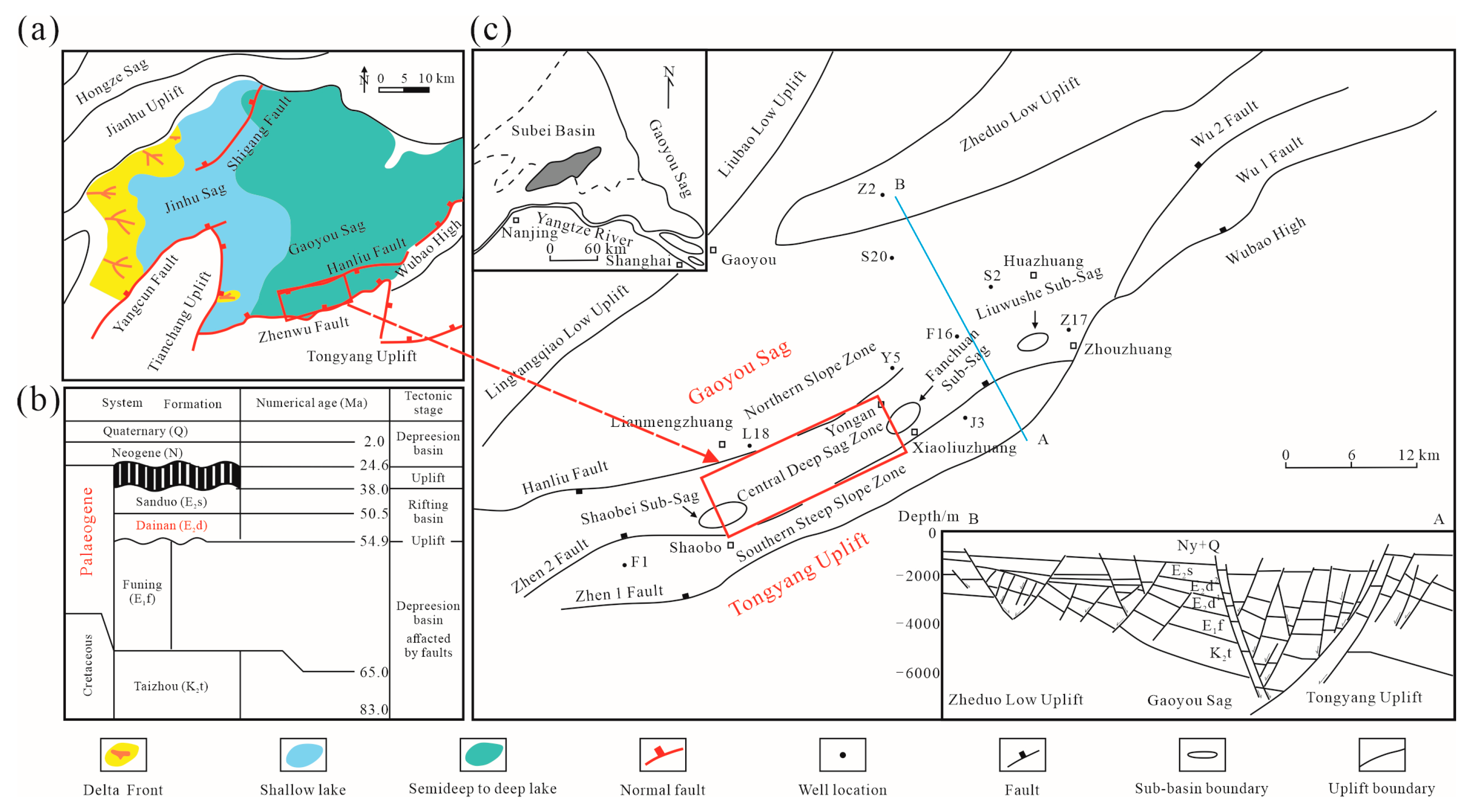
The Subei Cenozoic Basin in eastern China constitutes a characteristic multi-convex and multi-concave faulted basin system, demonstrating significant tectonic differentiation. Located along the southern margin of the Subei Basin (32°30′–33°00′ N, 119°20′–120°30′), the Gaoyou Sag study area is structurally bounded by four major basement uplift units: the Wubao High to the east, the Tianchang Uplift and Lingtangqiao Low High to the west, the Tongyang Uplift to the south, and the Zheduo Low Uplift to the north, collectively forming a NE-trending rhombic tectonic framework (Figure 1). This sag extends 100 km longitudinally with a 25–30 km latitudinal width, encompassing a total area of 2670 km2. Its architecture exhibits a distinctive half-graben configuration characterized by southern fault-bounded subsidence and northern onlap deposition [13,14].
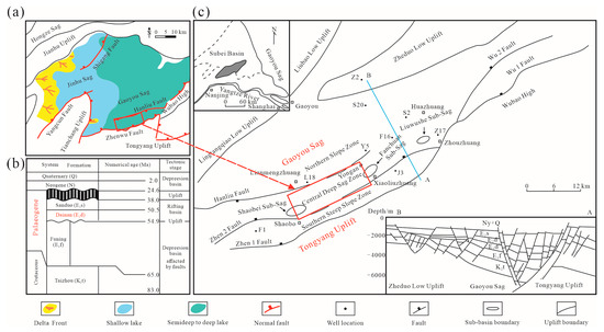
Figure 1.
Location and filling strata of the Gaoyou Sag, eastern China. (a) Location and sedimentary background of the Gaoyou Sag; (b) Filling strata and tectonic evolution in Dainan Formation of the Gaoyou Sag; (c) Structural units and tectonic profile of the Gaoyou Sag (red rectangle covered by the 3D seismic data).
The Gaoyou Sag represents a classic half-graben rift lacustrine basin, formed during the Late Cretaceous Yizheng Movement and the Late Paleocene Wubao Movement, primarily controlled by differential block subsidence. Within this sag, faulting activity was the principal manifestation of Meso-Cenozoic tectonism, exerting fundamental controls on the basin’s configuration, stratigraphic deposition/erosion patterns, and hydrocarbon accumulation. The southern boundary is demarcated by the Zhenwu Fault Zone (Figure 1), comprising listric normal faults (Zhen 1, Zhen 2, etc.) with vertical throws exceeding 3500 m. Internally, the Hanliu Fault Zone (800–1200 m throw) subdivides the sag into three structural zones: the southern fault terrace zone, the central deep depression, and the northern gentle slope zone. Additionally, over 650 NE-striking subsidiary faults (density: 2.8 faults/km2) mechanically associated with basin evolution govern the spatial distribution of depositional microfacies [15,16].
The sedimentary stratigraphy of the Gaoyou Sag contains primarily the Paleogene to Upper Cretaceous Taizhou Formation, with an accumulated thickness exceeding 7000 m. This stratigraphic column includes, in ascending order: the Upper Cretaceous Taizhou Formation, the Paleocene Funing Formation, the Lower Eocene Dainan Formation, the Middle Eocene Sanduo Formation, and the Miocene-Pliocene Yancheng Formation. The Lower Eocene Dainan Formation is of particular significance due to its hydrocarbon enrichment, attaining maximum thicknesses approaching 2000 m and exhibiting pronounced lithologic cyclicity characterized by coarse-fine-coarse-fine alternations. The lower Dainan Formation (E2d1) consists primarily of deltaic and sublacustrine fan deposits, comprising interbedded gray-black mudstones, sandstones, and pebbly sandstones with a cumulative thickness of −1000 m, showing an unconformable contact with the underlying Funing Formation. This interval is subdivided into three electrofacies-defined subunits (E2d13, E2d12, and E2d11) based on lithologic and geophysical log characteristics. The upper Dainan Formation (E2d2) is dominated by a braided delta with variable intercalations of light gray sandstones, siltstones, and brown to gray-black mudstones (100–900 m thick). This succession has been further partitioned into five subunits (E2d25 to E2d21) through integrated lithostratigraphic and electrofacies analysis.
Hydrocarbon exploration in the Gaoyou Sag has revealed that the Paleogene Dainan Formation hosts relatively small-scale and thin-bedded sand bodies that frequently form composite hydrocarbon reservoirs through lithologic-fault configurations. Particularly promising exploration targets occur in the central deep depression, where source rocks interface with sandstone in different depositional system tracts. This study focuses on a detailed analysis of the Lower Eocene Dainan Formation’s E2d1 interval (including E2d11, E2d12, and E2d13) and the basal E2d25 subunit. Through a systematic investigation of the sequence’s stratigraphic architecture, depositional system classification, spatio-temporal distribution of sedimentary facies, and seismic geomorphology, this research aims to establish a theoretical sequence and sedimentary framework and provide empirical support for hydrocarbon exploration in the sag.
3. Data and Method
The investigation focuses on the central deep depression of the Gaoyou Sag, where the study area encompasses 81 drilling and logging wells, including 28 cored wells yielding a total core length of 1080 m. The 3D seismic dataset exhibits dominant frequency ranges of 20–30 Hz, providing effective coverage across 240 km2 (red rectangle in Figure 1).
The 3D seismic data acquisition and processing for the central deep depression of the Gaoyou Sag were carried out through a systematic and multi-step workflow to ensure high-quality subsurface imaging. Seismic sources, including vibrator trucks, were strategically deployed across the 240 km2 survey area, with seismic receivers arranged on the surface and in boreholes to ensure comprehensive spatial coverage. The seismic frequency range of 20–30 Hz was selected to capture high-resolution data from the target depth, considering the complex geological conditions. Preprocessing steps, including noise suppression, static correction, and time-to-depth conversion, were essential for enhancing the clarity and accuracy of the data. Seismic imaging employed conventional stacking and advanced depth migration methods to account for the structural complexities of the region, allowing for precise subsurface modeling. The final 3D seismic volume was integrated with core and logging data from 81 wells, including 28 cored wells, to validate and refine the interpretation. This integration enabled the identification of key geological features and hydrocarbon reservoirs, providing a solid foundation for further seismic sedimentological research and exploration-development in the Gaoyou Sag.
Building upon seismic stratigraphy and seismic sedimentology, this investigation has achieved substantial improvements in the recognition and interpretation of depositional system tracts through the implementation of high-resolution stratal slice imaging techniques [1,15,16]. Compared to conventional seismic profile analysis, the proposed methodology demonstrates interpretation fidelity approaching core-scale resolution under specific lithostratigraphic conditions, therefore effectively reducing the seismic interpretation cycle by 32–45% in case study applications. The progressive development of 3D seismic exploration technologies and interpretation workflows has positioned seismic sedimentology as an indispensable analytical tool for basin evolution studies, system tract analyses, reservoir characterization, and hydrocarbon accumulation pattern analyses.
As an emerging post-stack seismic processing and interpretation method, spectral decomposition relies on the thin-bed tuning principle, serving as a critical tool for seismic sedimentological investigations. This technique transforms time-domain seismic data into frequency-domain representations through wavelet or Fourier transforms. Under the assumptions of constant seismic velocity, high-frequency components are sensitive to thin-bedded strata, whereas low-frequency responses primarily reflect thick-bed tuning characteristics. For sandbodies of indeterminate thickness, systematic frequency scanning identifies tuning-compliant frequencies, enabling thickness inversion through velocity-frequency relationships, thereby facilitating thin-bed detection [7,8,9,10].
4. Sequence Framework
The establishment of a robust sequence stratigraphic framework hinges on the integrated interpretation of geological and geophysical datasets to precisely delineate sequence boundaries and system tract interfaces. Specifically, three diagnostic markers: (1) seismic reflection termination patterns, (2) sedimentary lithofacies associations, and (3) well log facies signatures—have demonstrated superior reliability and operational feasibility in stratigraphic subdivision within continental sedimentary basins [1].
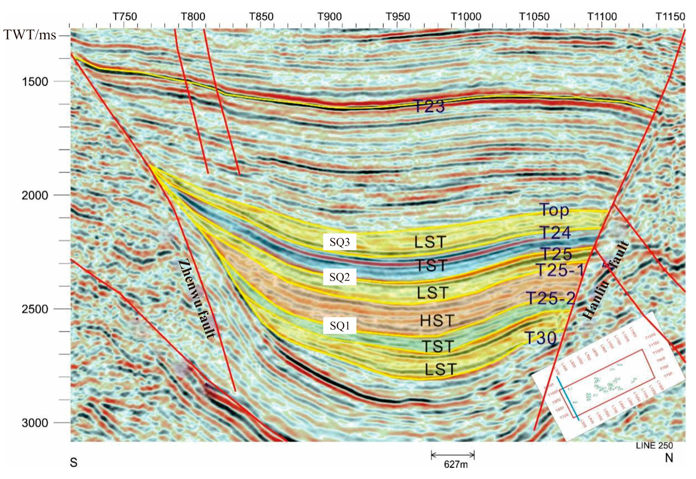
In this investigation of the Dainan Formation within the Gaoyou Sag, we systematically analyzed the third-order sequence boundaries and system tract interfaces through a detailed characterization of seismic event termination patterns (including truncation, onlap, downlap, and toplap configurations). A critical stratigraphic discovery reveals that along the Hanliu Fault Terrace Zone: (1) the initial coastal onlap point corresponds to the first flooding surface (FFS) controlled by the Hanliu Fault, while (2) the most distal coastal onlap point marks the maximum flooding surface (MFS) (Figure 2).
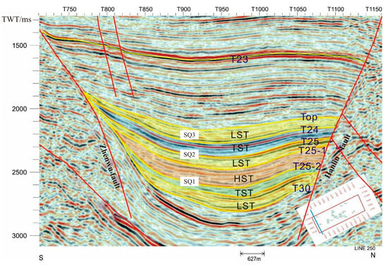
Figure 2.
Sequence stratigraphic framework and their seismic reflections in the Dainan Formation of the Gaoyou Sag (line 250).
Based on the constraints of seismic sequence boundaries, this study integrates core data characteristics including paleosols, basal conglomerates, and abrupt sedimentary facies changes. Through a comprehensive analysis of the lithological properties and electrofacies curve mutation interfaces of the Dainan Formation, combined with the identification of parasequence set stacking patterns (including retrogradational, progradational, aggradational, symmetrical retrogradation-progradation, and asymmetrical retrogradation-progradation types), we systematically determined sequence and system tract boundaries. The stratigraphic framework was ultimately established through well-seismic integration using synthetic seismogram calibration from 20 boreholes, achieving high-resolution sequence stratigraphic division. This integrated approach successfully constructed a robust sequence stratigraphic framework for the Dainan Formation, demonstrating remarkable consistency between well log responses and seismic reflection configurations.
Through a comprehensive integration of core analysis, well logging, and seismic interpretation, three third-order sequences (SQ1–SQ3) and eight system tracts were identified within the Paleogene Dainan Formation of the Gaoyou Sag, specifically encompassing the E2d11, E2d12, and E2d13 sub-members and the lower E2d25 interval. The stratigraphic architecture demonstrates a systematic progression (Figure 2). SQ1 (corresponding to E2d13 and lower E2d12) comprises lowstand (LST), transgressive (TST), and highstand (HST) system tracts. SQ2 (upper E2d12 to E2d11) contains LST and TST assemblages. SQ3 (equivalent to the Dainan Formation’s second member) exhibits a complete LST-TST-HST cyclicity (Figure 2). Spatio-temporal analysis reveals distinct lithofacies distributions controlled by structural dynamics. The LST deposits, constrained by dual tectonic controls from the Hanliu Fault-induced slope break zone and the southern Zhenwu Fault system, manifest as heterolithic successions of light gray sandstone/mudstone of variable thickness. In contrast, the TST and HST units demonstrate basin-wide continuity, characterized by dark gray mudstone interbedded with light gray sandstone, reflecting stable depositional conditions during maximum flooding.
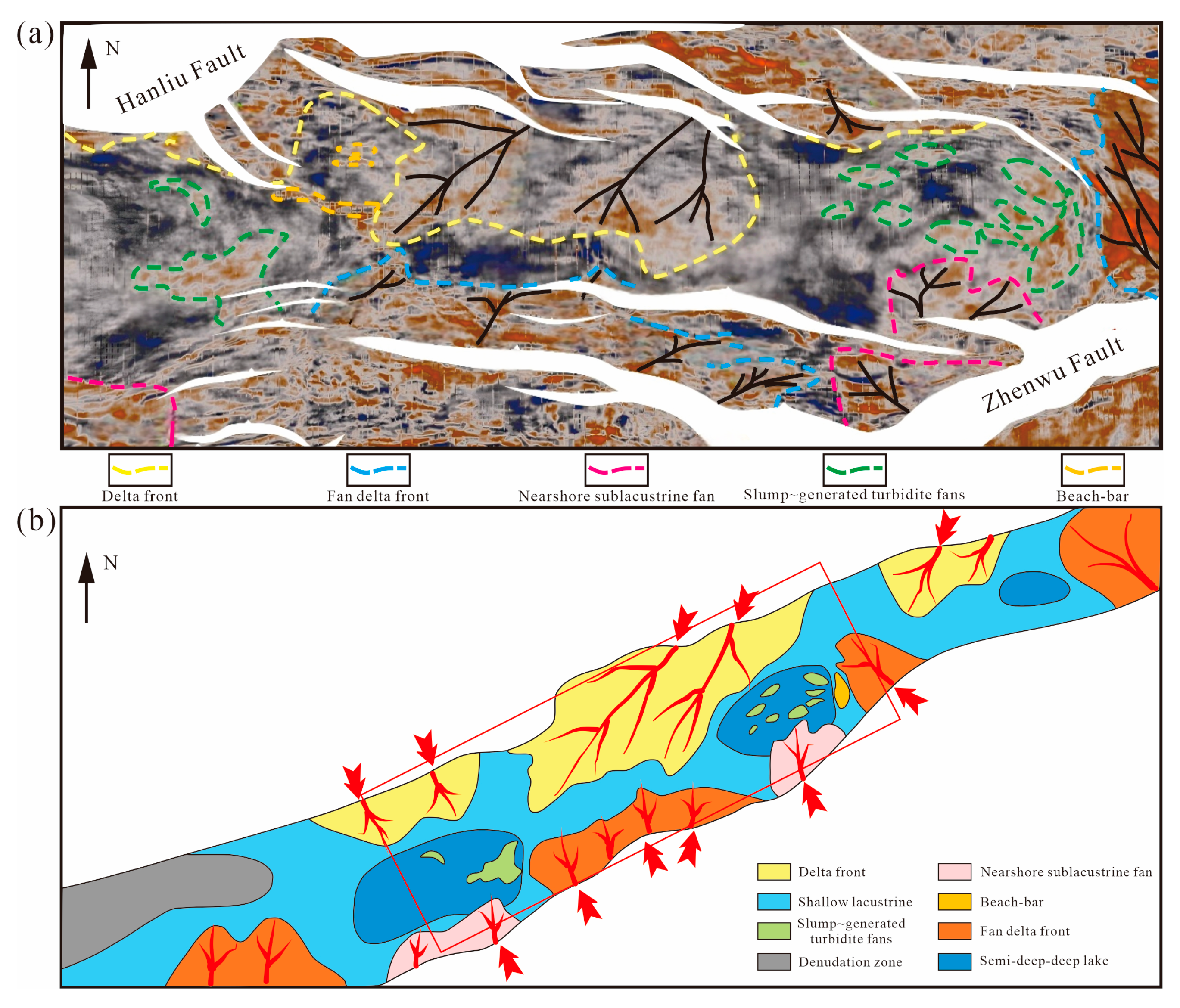
5. Depositional Systems
Integrating multiple geological controls including tectonic activity, sediment supply, and climatic conditions, this study identifies five depositional systems within the Dainan Formation of the Gaoyou Sag through systematic analysis of core facies, log facies, and seismic facies. These depositional systems are classified as deltaic, nearshore subaqueous fans, fan deltas, slump turbidite fans, and lacustrine systems. Their development and spatial distribution are fundamentally governed by the three-dimensional constraints of basin architecture, evolutionary stages of structural deformation, and sequence framework. Detailed facies mapping reveals significant structural control on depositional patterns. (1) The southern steep slope zone, characterized by intense faulting, predominantly hosts nearshore subaqueous fans and fan delta complexes. (2) The northern gentle slope domain features well-developed normal deltaic systems, indicating stable sedimentary conditions. (3) Littoral-shallow lacustrine facies encircle the basin margins, while deep and semi-deep lacustrine environments with slump turbidite fans are concentrated in central basin depocenters. This tripartite distribution demonstrates distinct zonal differentiation controlled by syndepositional fault activity and paleogeomorphological evolution [13].
Among the diverse depositional systems, deltaic facies constitute the principal reservoir sand bodies in the Dainan Formation of the Gaoyou Sag. The delta plain subfacies is dominated by conglomeratic sandstones exhibiting prominent scouring surfaces with sporadic clasts. Well-developed upward-fining sequences transition from medium- to fine-grained sandstones to silt-fine sandstones. These sandstones display massive bedding, trough cross-bedding, and parallel lamination, frequently interbedded by brown mudstone. The delta front subfacies consists predominantly of light gray to brown fine sandstones and siltstones intercalated with gray to dark gray mudstones. Basal scouring surfaces with well-rounded mud clasts are prevalent, accompanied by well-developed cross-bedding, parallel bedding, and climbing ripples. Progressing basinward, the prodelta environment is characterized by deep-water dark mudstones with intercalated slump-generated sandy mudstones or muddy sandstones that exhibit diagnostic soft-sediment deformation structures, including ball-pillow structures and convolute beddings (Figure 3). This vertical succession records distinct hydrodynamic energy gradients ranging from proximal high-energy fluvial-dominated settings to distal low-energy basinal environments.
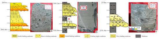
Figure 3.
Sedimentary characteristics of deltaS in the Dainan Formation of the Gaoyou Sag. (a) Delta plain, well Y24, 2841.37m; (b) Delta front, well Y38, 3181.85m; (c) Prodelta, well L24, 2374.2 m. Star symbols indicate the depth locations corresponding to the core photographs in the right pane.
The slump-generated turbidite fans are predominantly distributed within the central subsag zone of the Gaoyou Sag, developing along the hanging walls of the Hanliu and Zhenwu faults. These gravity-flow deposits exhibit distinctive characteristics: coarse-grained turbiditic sandstones and conglomerates are interbedded with deep to semi-deep lacustrine dark gray mudstones, forming fining-upward rhythmic successions. Well log responses show distinctive finger-shaped or serrated bell-shaped patterns on spontaneous potential (SP) curves, with individual sand bodies measuring 2–3 m in thickness. The deposits preserve classic gravity-driven sedimentary structures, including massive bedding, parallel lamination, and graded bedding as well as syndepositional deformation features such as scour-fill structures, ball-pillow configurations, loaded casts, and slump-induced contortions.
The nearshore sublacustrine fan (NSF), as a diagnostic depositional system in steep slope zones of faulted lacustrine basins, is preferentially developed along the hanging wall of the southern boundary fault in the Gaoyou Sag. This coarse-grained system exhibits distinct lithofacies cyclicity, characterized by rhythmic alternations of medium to fine-grained conglomerates (45–68% gravel content) and deep gray mudstone beds (2–5 m thick), demonstrating a strong provenance affinity. Provenance-ward grain-size coarsening is evidenced by an increase in mean gravel diameter from 8.2 mm to 23.5 mm (n = 157 measurements), accompanied by a 12.3 ± 1.8% quartz content reduction. Sedimentary architecture reveals: (1) gravity-flow signatures featuring well-developed imbrication structures (Imbrication Index = 0.72–0.85), clast-supported fabric, and basal scours; (2) the absence of tractive current sedimentary structures. Wireline log responses display blocky-bell motifs with gamma ray (GR) values ranging from 80 to 120 API, indicative of normal grading sequences. Seismically, these fans exhibit wedge-shaped seismic facies with chaotic reflections proximal to fault zones (continuity index < 0.3), transitioning basinward to parallel-continuous reflections (continuity index > 0.7). This seismic and geological configuration records a depositional continuum from proximal high-energy to distal low-energy environments, controlled by decreasing sediment supply rates and increasing hydrodynamic sorting toward the sag center.
The fan delta (FD), formed by alluvial fans prograding into lacustrine environments, constitutes a prominent depositional system within the southern steep slope zone of the Gaoyou Sag. The delta plain subfacies is dominated by sandy-gravel braided channel deposits, comprising matrix-supported conglomerates (sorting coefficient σ = 2.8–3.5) interbedded with brownish-gray mudstones, exhibiting low compositional and textural maturity. Characteristic sedimentary structures include scour surfaces, tabular and trough cross-bedding, and massive bedding, forming vertically stacked upward-fining sequences. The delta front subfacies features conglomeratic sandstones and sandstones intercalated with grayish-green to gray silty mudstones. These coarse-grained deposits display scour bases, large scale cross-bedding, and parallel laminations. The interbedded fine-grained facies (light grayish-green, brown, purplish-red, and pale gray mudstones/siltstones) exhibit horizontal bedding, wavy bedding, and lenticular bedding, often containing abundant mica flakes on bedding planes. Diagnostic biogenic features include plant-derived charcoal fragments and bioturbation structures.
The lacustrine facies, extensively developed throughout the Dainan Formation, consist predominantly of fine-grained lithologies. Shore-shallow lacustrine deposits, influenced by frequent lake level fluctuations, are composed of brown-gray siltstones, argillaceous siltstones, silty mudstones, and dark brown mudstones. These deposits display horizontal bedding, wavy bedding, subvertical burrows, bio-perturbation structures, and plant rhizome fossils (Figure 4). Corresponding well log responses feature low-amplitude linear patterns on spontaneous potential (SP) curves and serrated medium-low resistivity values. In contrast, semi-deep to deep lacustrine facies developed under anoxic, weakly reducing to reducing conditions are characterized by dark gray to black mudstones and calcareous mudstones with horizontal lamination. Diagnostic components include pyrite nodules and well-preserved ostracod fossils (Figure 4). These deposits exhibit stable SP curve baselines and slightly undulating apparent resistivity profiles, reflecting persistent deep-water depositional environments
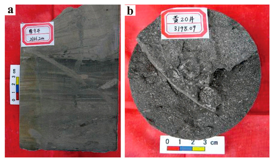
Figure 4.
Core photos of lake sediments of the Dainan Formation of the Gaoyou Sag (a) Fine sandstone with burrow pore in littoral-shallow lake, well Y9, 2686.2 m (b) Gray mudstone of semi-deep lake with horizontal bedding, well H20, 3198.1 m.
6. Seismic Sedimentology Technology
Seismic sedimentology is based on the theoretical frameworks of modern sedimentology and geophysics. This discipline uses 3D seismic datasets with sequence stratigraphic analysis, seismic attribute interpretation, and stratal slicing techniques (calibrated with core data) to investigate macroscopic lithological characteristics, sandbody distribution patterns, depositional systems, and their evolutionary history within sedimentary basins [1,15,16,17,18,19]. Stratal slicing not only provides geomorphological imagery for reconstructing the evolution of depositional systems within sequence stratigraphic frameworks, but also reveals the spatio-temporal distribution characteristics of depositional configurations across different system tracts [15,16]. The principal methodological approaches in seismic sedimentology encompass:
6.1. 90° Phase Adjustment
When seismic reflections originate from thin-bedded sandbodies, direct correlations between sandstone layers and seismic events are inherently ambiguous. This challenge is addressed through 90° phase rotation or shift, a technique that aligns the central lobe of the seismic wavelet with the geometric centers of thin sandbodies. This allows for the establishment of a robust correlation between seismic events and subsurface lithology. Comparative analysis of 0°and 90° phase seismic models demonstrates that phase-adjusted data significantly enhances the interpretability of thinly layered geological features. Furthermore, 90° phase models exhibit improved agreement with acoustic impedance profiles and well logging data. Direct waveform comparison with impedance data enables systematic analysis of the relationship between seismic events and stratigraphic architecture [15,16]. This phase adjustment methodology substantially reduces the uncertainties associated with thin-bedded sandbody identifications and streamlines workflow efficiency.
Post-rotation seismic profiles of the Dainan Formation reveal enhanced phase-to-lithology correlation. Notably, nearly all of the penetrated sandstone units correlate with seismic troughs (denoted in red, see Figure 2), rendering the seismic sections more geologically intuitive. This transformation clarifies the litho-seismic relationship. Interpreted seismic events directly represent sandbody geometries, thereby assigning seismic reflections explicit stratigraphic significance. The optimized phase alignment enables direct mapping of sandstone distributions through continuous event tracking, effectively bridging geophysical data with sedimentological interpretations.
6.2. Spectral Decomposition Technique
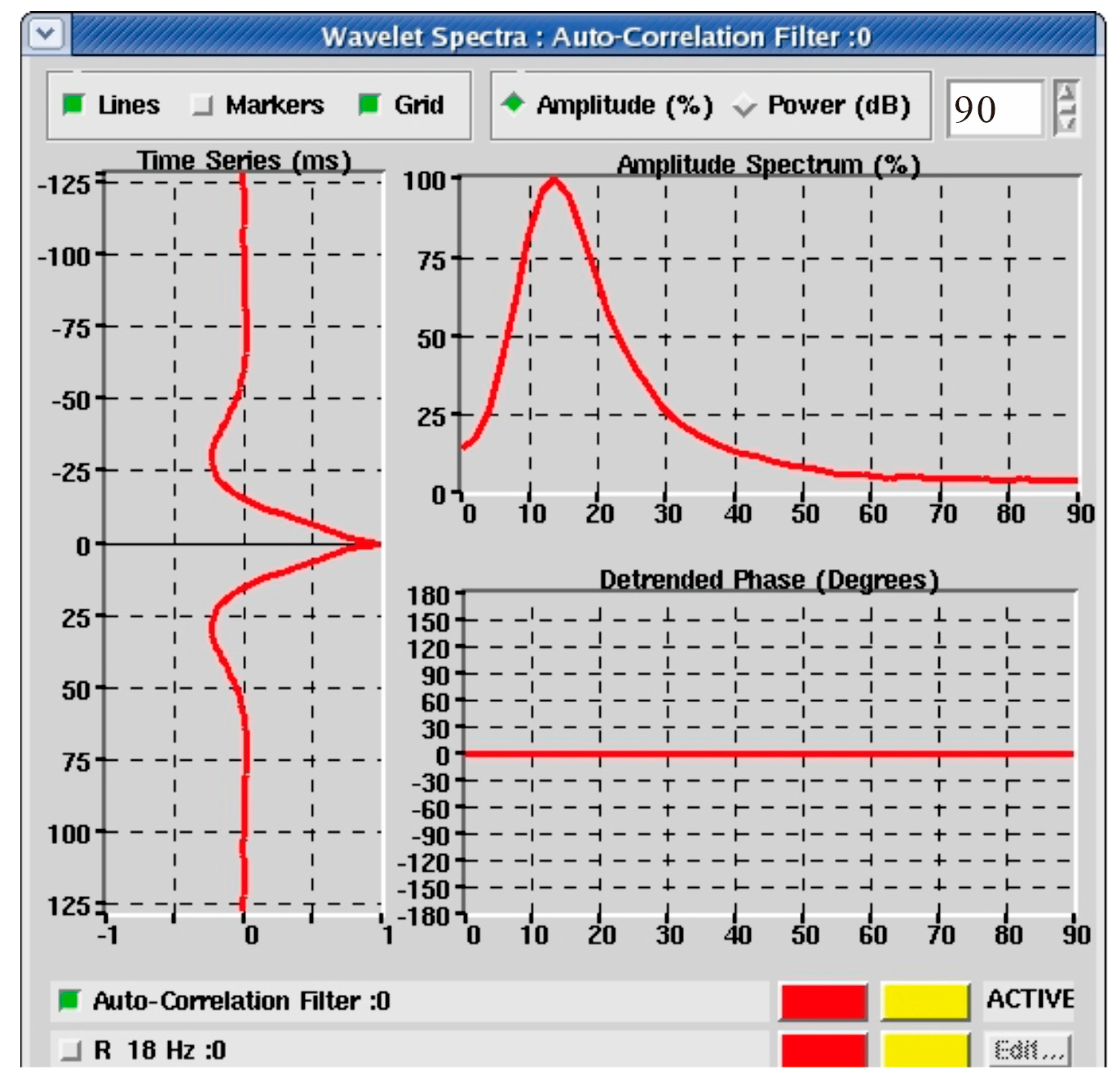
Spectral analysis of seismic data from the Dainan Formation in the Gaoyou Sag revealed a dominant frequency range of 20–30 Hz (Figure 5). The study computed spectral energy distributions across 8–64 Hz, segmenting 3D seismic volumes into six frequency bands (8–12 Hz, 12–16 Hz, 16–24 Hz, 24–32 Hz, 32–48 Hz, and 48–64 Hz). Each band generates a corresponding root mean square (RMS) amplitude slice. Comparative analyses have demonstrated significant frequency-dependent geological responses, with the 16–24 Hz band exhibiting exceptional resolution for thin-bed identification.
Figure 5.
Seismic wavelet amplitude spectrum in the Dainan Formation of the Gaoyou Sag.
Frequency-partitioned slices surpass conventional amplitude/phase slices in detecting subtle lateral depositional variations and resolving heterogeneous sedimentological features. Notably, spectral energy maps maintain diagnostic clarity even when attribute boundaries appear ambiguous. The technique’s primary advantage lies in its capacity to reveal subtle attribute variations through animated frequency slice visualization. When integrated with core-derived sedimentary sequences and depositional models, this approach enables effective analysis of lateral reservoir heterogeneity within target intervals.
6.3. Stratal Slicing
Stratal slicing has emerged as a novel technique in basin analysis and sandbody characterization, distinguished by its high resolution and ability to delineate depositional interfaces with enhanced precision. This approach facilitates the generation of numerous sequence framework-constrained slices, thereby providing robust support for basin-scale investigations and sequence stratigraphic studies [10,11].
As extensively documented in sedimentological research, sedimentary bodies typically exhibit lateral dimensions significantly exceeding their vertical thickness [2]. Consequently, seismic attributes derived from planar distributions prove particularly effective in identifying thin-bedded deposits, which often challenge detection through vertical resolution-limited seismic interpretation. This fundamental characteristic underpins the development of stratal slicing technology. The interpretation of stratal slices constitutes an integrated research process that synthesizes well log data, core analysis, and depositional geomorphological patterns to systematically characterize depositional systems and their domains [10,11,15,16]. The litho-seismic relationship manifests through specific amplitude patterns. (1) Positive amplitudes typically correspond to shale intervals, whereas negative amplitudes indicate sandstone layers or condensed sections. (2) Variable/low-amplitude responses may represent thin-bedded sandstone/shale alternations, while prominent negative amplitudes often correspond to gas-bearing sandstones [17,18,19,20,21,22,23]. These diagnostic relationships demonstrate the critical value of stratal slicing in reconstructing sedimentary facies and evolutionary histories from seismic datasets. The seismic profiles from the Dainan Formation in the Gaoyou Sag’s deep depression zone present exceptional characteristics for seismic sedimentological analysis, including superior data quality, a high signal-to-noise ratio, and well-defined seismic waveform features. This investigation employs stratal slicing combined with seismic attribute interpretation to reconstruct the dynamic evolution of depositional systems and associated sandbodies within sequence stratigraphic frameworks. The resultant findings provide substantial geological evidence supporting the exploration of lithologic traps in this hydrocarbon-prone basin.
7. Seismic Image of Different System Tracts
The investigation reveals that stratal slices derived from amplitude-based attributes exhibit pronounced energy signatures of depositional elements. The sandbody distribution patterns within the Dainan Formation across distinct structural zones of the Gaoyou Sag—including the northern gentle slope, southern steep slope, and central deep depression—demonstrate favorable geological conditions for detailed depositional system characterization and sandbody geometry analysis. These findings establish a critical foundation for systematic sedimentological investigations in this hydrocarbon-bearing basin.
However, direct lithology prediction using polarity or amplitude attributes from stratal slices necessitates rigorous petrophysical calibration. This process requires an integrated analysis of well logging data and core observations to establish robust correlations between lithological units and acoustic impedance variations [24,25,26,27,28,29]. In operational practice, empirical relationships between acoustic transit time and sand/shale thickness ratios serve as principal diagnostic tools.
Petrophysical analysis of the Dainan Formation in the Gaoyou Sag indicates systematic lithologic differentiation. Shale intervals exhibit elevated acoustic transit time values (typically 280–320 us/m) while sandstone units display significantly lower values (210–250 us/m), enabling clear lithologic discrimination. Building upon this diagnostic relationship, our research team implemented stratal slice partitioning constrained by system tract boundaries, integrating well calibration and seismic geomorphologic analysis to delineate spatio-temporal distributions of depositional systems within discrete stratigraphic frameworks.
The following analysis focuses on sequence SQ1 of the Gaoyou Sag’s Dainan Formation to elucidate the evolutionary characteristics of depositional systems across different system tracts (Figure 2).
7.1. Temporal and Spatial Distribution of SQ1 Lowstand System Tract
The SQ1 lowstand system tract (LST) of the Dainan Formation in the Gaoyou Sag represents an early depositional phase corresponding to the lower part of the E2d13 sequence (Figure 6). The sediment thickness can reach up to 400 m, although its distribution is relatively limited. During this period, sedimentation primarily exhibited infill deposition characteristics, with significant fault activity influencing the development of the sequence’s stratigraphy. The southern Zhenwu Fault delineates the boundary of the depression while the northern Hanliu Fault acts as a slope break zone, thereby determining the spatial distribution of the LST.
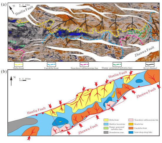
Figure 6.
Stratal slicing and depositional system of SQ1 LST in the Dainan Formation of the Gaoyou Sag (Slice 3305). (a) Stratal Slice 3305 Representing the LST of SQ1 in the Dainan Formation, Gaoyou Sag; (b) Planar Interpretation of Sedimentary Facies Corresponding to Representative Stratal Slices in the LST of SQ1, Dainan Formation, Gaoyou Sag.
In Figure 6, slice 3305 is located at the base of the SQ1 LST. Analysis of core and logging data reveals that red amplitudes correspond to sandstone facies while black or deep blue amplitudes correspond to mudstone facies. Based on the classification results from the core data, it is evident that in the northern part of the study area, the sandstone facies primarily exhibit characteristics of delta front deposition, with a relatively large distribution area that allows for the identification of five clearly defined lobe bodies (Figure 6). In contrast, the southern region displays sandstone facies indicative of fan delta front or nearshore subaqueous fan deposition, which is significantly influenced by fault activity, resulting in a relatively smaller distribution range of the fan bodies. Additionally, a small number of slump turbidite fans can be observed in the deep trough, characterized by an elliptical shape and sporadic distribution (Figure 6).
Statistical analysis of sandstone thickness and sand-to-mud ratio data from the SQ1 LST in the Dainan Formation of the Gaoyou Sag reveals that the northeastern Fumin area, the vicinity of Well Zhen 2 in the central region, and the Yong’an area exhibit greater sandstone thicknesses, reaching 50 to 75 m, while other areas generally have sandstone thicknesses of less than 15 m. Furthermore, the sand-to-mud ratio demonstrates a significant directional trend, gradually increasing from the lake basin toward the provenance area. By integrating the contour maps of sandstone thickness and sand-to-mud ratio with the amplitude attribute analysis of stratal slices and referencing the sequence stratigraphic framework, a sedimentary facies map of the SQ1 LST was ultimately constructed (Figure 6).
The study indicates that during the LST deposition period, the Dainan Formation in the Gaoyou Sag was in the early developmental stage of a faulted lake basin, characterized by intense tectonic activity, significant topographic relief, and deeper water in the deep trough. In the southern steep slope zone, provenance materials could directly enter deeper water areas, leading to the formation of nearshore subaqueous fan deposits. In the northern part of the study area, provenance materials originated from the northern Zheduo Low Uplift, primarily developed delta front deposits and a small number of slump turbidite fans. In the deep trough, the distribution area of semi-deep to deep lacustrine facies is relatively small, with the predominant facies being shallow lacustrine deposits (Figure 6).
7.2. Temporal and Spatial Distribution of SQ1 Transgressive System Tract
The transgressive system tract (TST) of the Dainan Formation SQ1 corresponds to the upper part of the E2d13 sequence (Figure 2) and represents the lake expansion phase. During this period, the lake basin significantly expanded, with the sedimentary boundary crossing the Hanliu Fault to the north and the sedimentary center located in the central region of the deep trough, where the maximum sediment thickness reaches 150 to 250 m.
In the stratal slices of the TST (Figure 7), black amplitudes, which are indicative of mudstone facies, occupy the vast majority of the study area. However, in the northern Yong’an area, lobate red amplitudes, indicatives of delta front sands, remain discernible, albeit with a weaker amplitude intensity and a reduced distribution area. In the southern regions of Zhenwu and Caozhuang, the distribution of red amplitudes representing fan delta front sands is relatively stable. Additionally, in the southern steep slope zone, particularly in the Shaobo and Xiaoliuzhuang areas, red amplitudes primarily develop as nearshore subaqueous fans (Figure 7). Notably, in the area west of Zhenwu, near the Shaobei sub-trough (e.g., around Well Shaoshen 1), the distribution of slump turbidite fans is relatively stable and retains the distribution characteristics previously observed in the slump turbidite fans of the SQ1 LST. Furthermore, numerous elliptical red amplitude bodies, attributed to slump turbidite fans, have also developed within the Fanchuan sub-trough (Figure 7).
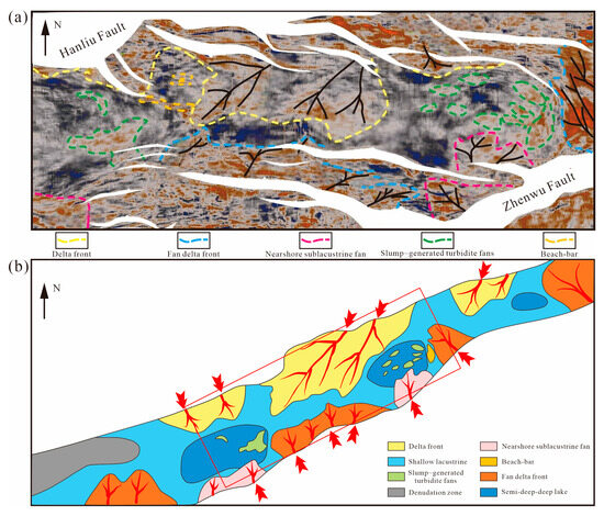
Figure 7.
Stratal slicing and depositional system of SQ1 TST in Dainan Formation of the Gaoyou Sag (Slice 2510). (a) Stratal Slice 2510 Representing the TST of SQ1 in the Dainan Formation, Gaoyou Sag; (b) Planar Interpretation of Sedimentary Facies Corresponding to Representative Stratal Slices in the TST of SQ1, Dainan Formation, Gaoyou Sag.
Regarding sandstone thickness and the sand-to-mud ratio, the overall sandstone deposition thickness during the TST period is relatively low (less than 30 m). However, approaching the provenance source, the sand-to-mud ratio gradually increases, reaching a maximum of 0.5. This indicates that during the TST period, the lake basin continued to expand, accompanied by a slight retreat of the deltaic sedimentary belt on the northern slope. Within the Shaobo sub-trough, located on the downthrown side of the Hanliu Fault, slump turbidite fans are well developed (Figure 7). The nearshore subaqueous fans in the southern Shaobo sub-trough and Fanchuan sub-trough also exhibit a landward retreat. Meanwhile, the supply of source materials from the southeastern Wubao low uplift is relatively abundant, leading to the sustained development of fan delta deposits in the Zhouzhuang area (Figure 7).
7.3. Temporal and Spatial Distribution of SQ1 Highstand System Tract
The highstand system tract (HST) of SQ1 corresponds to the E2d12 sublayer of the Dainan Formation, with its sedimentary region largely consistent with that of the transgressive phase. The HST sedimentation center is primarily distributed within the Shaobo and Fanchuan sub-trough structural belts, with a maximum sediment thickness of up to 200 m.
Analysis of the HST stratal slices reveals that the northern region exhibits strong characteristics of deltaic systems, with significantly enhanced amplitude intensity and a distribution area substantially larger than that of the TST. From east to west, five progressively larger deltaic lobes can be identified. In contrast, the southern regions of Zhenwu and Caozhuang show a northward trend in red amplitudes indicative of fan delta sands, contrasting with the northern area (Figure 8). The sedimentary characteristics in the Huangjue, Zhenwu, Caozhuang, and Fumin regions indicate that these areas are dominated by fan delta systems as the primary depositional types. In terms of sedimentary environment, the SQ1 HST phase performs during the mid-evolution of a faulted lake basin, with the Shaobo sub-trough, Fanchuan sub-trough, and Liu Wushe sub-trough exhibiting a sedimentary setting ranging from semi-deep to deep lake conditions. Nearshore subaqueous fan deposits are well-developed in the southern faulted slope zone, particularly in the Shaobo, Xiaoliuzhuang, and southern Zhouzhuang areas adjacent to the Liu Wushe sub-trough. Conversely, the Huangjue, Zhenwu, Caozhuang, and Fumin regions are characterized by a typical fan delta system (Figure 8). The northern Majiazui area serves as a major provenance area west of Weizhuang, developing a typical deltaic system. In the northern slope regions of Yong’an, Fumin, and Lianhezhuang, the sediment supply primarily originates from the northern Zheduo Low Uplift, resulting in the development of delta front subfacies with a higher compositional maturity. Notably, the SQ1 HST period is marked by large scale and inherited development, leading to the extensive formation of slump turbidite fans within the Shaobo and Fanchuan sub-troughs.

Figure 8.
Stratal slicing and depositional system of SQ1 HST in Dainan Formation of the Gaoyou Sag (Slice 1412). (a) Stratal Slice 1412 Representing the HST of SQ1 in the Dainan Formation, Gaoyou Sag; (b) Planar Interpretation of Sedimentary Facies Corresponding to Representative Stratal Slices in the HST of SQ1, Dainan Formation, Gaoyou Sag.
7.4. Sedimentary Distribution and Lithological Traps in Different System Tracts
During the deposition of the SQ1 LST of the Dainan Formation, intense fault activity was prevalent. The southern Zhenwu Fault formed the southern boundary of the sag, while the northern Hanliu Fault acted as a boundary of a faulted slope break zone, resulting in sedimentation being confined to the deep trough area between the Zhenwu Fault and the Hanliu Fault. The subsidence center is located within the Shaobo sub-trough, where the sandstone thickness exhibits a distinct spatial variation characterized by a higher thickness in the east and lower thickness in the west, with maximum values exceeding 60 m, particularly prominent in the eastern Yong’an and Fumin areas. During this period, fan delta systems developed in the southern regions, including Huangjue, Zhenwu-Caozhuang, Fumin, and Zhouzhuang. The northern provenance materials originated from the Zheduo Low Uplift, entering the lake basin via two pathways, forming large deltas in the Yong’an and Fumin areas, while smaller-scale deltas developed in the Lianhezhuang area. The central part of the depression primarily featured a shallow lacustrine sedimentary environment, with smaller semi-deep to deep lake deposits developing in the Shaobo, Fanchuan, and Liuwushe sub-troughs.
During the SQ1 TST and HST of the Dainan Formation, tectonic activity significantly decreased, leading to a gradual deepening of the water body. The sedimentary boundary extended southward across the Zhenwu Fault and northward beyond the Hanliu Fault. In the southern region, fan deltas developed sequentially from west to east, including Huangjue, Zhenwu-Caozhuang, Fumin, and Zhouzhuang, while the Shaobo and Xiaoliuzhuang areas preserved earlier sedimentary features, forming nearshore subaqueous fans. The northern regions of Yong’an, Fumin, and Lianhezhuang continued to develop deltaic systems. Due to the increased accommodation space and abundant sediment supply during this period, the overall scale of fan body development expanded considerably, with slump turbidite fans primarily distributed within the Shaobo and Fanchuan sub-troughs.
Overall, during the SQ1 deposition of the Dainan Formation, the Gaoyou Sag was in the rifting phase of a faulted basin, exhibiting a graben-like structure. The northern gentle slope zone was dominated by deltaic to shallow lacustrine sedimentary systems, particularly in the Yong’an to Fumin area. The southern part of the Lianhezhuang area, located on the downthrown side of the Hanliu Fault, exhibited a multi-sediment supply, initially receiving delta front deposits from the northeastern Zheduo Low Uplift and later influenced by provenance materials from the northwestern Lingtangqiao area. The southern faulted slope zone was characterized by a depositional system comprising fan deltas, nearshore subaqueous fans, and lake deposits, reflecting multiple provenances, multiple sedimentary centers, and overlapping fan bodies. Due to the influence of sediment supply and paleogeographic conditions, the distribution scale of each fan delta and nearshore subaqueous fan varied, generally showing an eastward increase in size. Within the central deep trough, the dominant depositional system consisted of slump turbidite fans, semi-deep lakes, and deep lakes, with a favorable symbiotic relationship between slump turbidite fans and deltaic, fan delta, and nearshore subaqueous fan deposits (Figure 9).
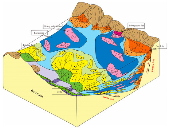
Figure 9.
SQ1 sedimentary schematic diagram of the Dainan Formation in the Gaoyou Sag.
Exploration results indicate that lithological-structural traps are primarily distributed within the LST of the Dainan Formation, with their formation attributed to four main factors: First, various sandstone bodies in the LST are concentrated in the deep trough area (e.g., deep lake Figure 7), adjacent to hydrocarbon source rocks. The major faults within the trough serve as natural oil migration pathways, providing favorable conditions for hydrocarbon accumulation. Second, the single-layer thickness of sandstone bodies in the LST generally ranges from 3 to 6 m and exhibits favorable physical properties. Third, the overlying strata of the LST are primarily composed of mudstone formations resulting from the TST, which provide excellent sealing conditions. Finally, the basin is predominantly characterized by reverse normal faults, which can facilitate hydrocarbon accumulation during fault activity and effectively seal hydrocarbons with the mudstones of the TST after trap formation. These combined factors create favorable conditions for the formation of lithological-structural traps of oil and gas pools.
8. Discussions
This study conducts a comprehensive analysis of the sequence stratigraphy and seismic sedimentology of the Dainan Formation in the Gaoyou Sag, highlighting the types and temporal-spatial development patterns of depositional systems within a faulted lake basin. The findings indicate that the sedimentary environment of the faulted lake basin was controlled by tectonic activity, the evolution of the lake basin, and variations in the sediment supply. Specifically, the LST, TST, and HST exhibit distinct sedimentary characteristics, and the spatial distribution and evolutionary processes of these depositional systems are influenced by the sequence framework and the different tectonic stages of the Gaoyou Sag.
8.1. Sedimentary Characteristics and Tectonic Control in the LST
During the LST phase of SQ1, the sediments primarily exhibit characteristics of delta front and fan delta deposits, with sedimentary areas significantly influenced by tectonic activity. Seismic data reveal that the depositional systems in the southern steep slope zone are controlled by fault activity, resulting in the formation of nearshore subaqueous fans and small fan deltas, while the northern gentle slope zone is predominantly dominated by more stable delta front deposits. Sandstone deposition during the LST is concentrated in the deep trough, displaying distinct lobe body sedimentary features, with substantial thickness and high sand-to-mud ratios. Statistical analysis of sandstone thickness and sand-to-mud ratios indicates significant regional variations, which are closely related to tectonic activity (Figure 6).
8.2. Evolution and Sedimentary Characteristics of the TST
In the TST phase of SQ1, the Gaoyou Sag significantly expands and the distribution of sediments migrates toward the deeper parts of the basin. The area of deep lake facies expands considerably while the sediment scale of the northern delta front declines significantly. Throughout the sedimentation process, the thickness of sand bodies gradually decreases, indicating a progressive reduction in sediment supply rates. During the TST, the spatial distribution of sediments is less influenced by tectonic activity, as the expansion of lake waters drives the sedimentary center to gradually migrate toward deeper water areas. Notably, in the southern fault zones, the sedimentary areas of fan deltas and nearshore subaqueous fans exhibit relatively stable distribution characteristics, maintaining a degree of inheritance from the sedimentation patterns observed during the LST of SQ1 (Figure 7).
8.3. Sedimentary Characteristics of the HST and Their Genetic Analysis
During the HST phase of SQ1, the sedimentation pattern is characterized by a combination of delta, fan delta, and nearshore subaqueous fan deposits. The sandstone deposits of the HST exhibit higher compositional maturity, with an expanded distribution range, particularly in the southern faulted slope zone, where the combination of fan deltas and nearshore subaqueous fans displays complex superimposed relationships. In the deep trough, the development of slump turbidite fans shows a distinct paired pattern, closely related to tectonic uplift and variations in sediment supply. By integrating seismic attributes and lithological data, we can further clarify the temporal-spatial evolution patterns of sediments during the HST and their relationship with fault zones (Figure 8).
8.4. Coupling Mechanism of Depositional Systems and Lake Basin Evolution
This study reveals a close coupling between depositional systems and tectonic evolution. Throughout the LST, TST, and HST phases, changes in depositional systems are influenced not only by lake transgression but also by fault activity and variations in provenance supply. Notably, during the TST and HST phases, tectonic activity results in significant differences in the spatial distribution of depositional systems, with the symbiotic relationship between slump turbidite fans and deltaic, nearshore subaqueous fan deposits reflecting the complex evolutionary processes of the lake basin. This coupling mechanism profoundly impacts the temporal-spatial evolution patterns of depositional systems, providing valuable insights for subsequent oil and gas exploration efforts.
9. Conclusions
On the basis of the analysis of sequence stratigraphy and seismic sedimentology of the Dainan Formation in the Gaoyou Sag, the developmental types and spatio-temporal evolution of depositional systems in each system tract in the faulted lake basin are discussed.
- (1)
- Based on the relationships of seismic reflection terminations and sedimentary cyclic characteristics in the Dainan Formation of the Gaoyou Sag, the Paleogene Dainan Formation can be divided into three third-order sequences, each comprising corresponding LST, TST, and HST system tracts. The sediment thickness of each third-order sequence ranges from 300 to 500 m, with the stratigraphic distribution primarily controlled by the boundary faults of the sag, intra-basin fault activity, and fluctuations in lake level.
- (2)
- The Dainan Formation in the Gaoyou Sag comprises five sedimentary types: normal deltas, fan deltas, nearshore subaqueous fans, slump turbidite fans, and lake deposits. The distribution and characteristics of these sedimentary facies are influenced by the tectonic activities of the lake basin and the various stages of tectonic evolution. Specifically, the steep slope zone is dominated by nearshore subaqueous fans and fan deltas, while the gentle slope zone primarily develops normal deltas. Shallow lacustrine facies are distributed along the margins of the lake basin, whereas deep to semi-deep lake and slump turbidite fans are found in the central regions of the faulted lake basin.
- (3)
- The optimal seismic tuning frequency for sandstone thickness in the Dainan Formation of the Gaoyou Sag is between 16 and 24 Hz, based on the methods of seismic sedimentology. Amplitude-based seismic attributes effectively characterize the morphology of sandstone bodies and the distribution features of depositional systems in the northern gentle slope, southern steep slope, and central deep trough across different system tracts. Specifically, during the LST and HST deposition periods, the northern gentle slope zone develops multiple lobe-shaped deltas, while the southern steep slope zone is primarily characterized by fan deltas or nearshore subaqueous fans. Slump turbidite fans are primarily distributed in the deep trough. In contrast, during the TST deposition period, the scale of deltas in both the northern gentle slope and southern steep slope zones decreases significantly, while the deep trough develops deeper lake deposits.
Author Contributions
Conceptualization, X.Z. and Q.Z.; Methodology, X.Z. and X.H.; Software, X.H.; Validation, Y.X.; Formal Analysis, X.H., Y.D. and Q.Z.; Investigation, X.H.; Resources, X.Z.; Data Curation, X.H., Y.D. and X.W.; Writing—Original Draft Preparation, X.Z., X.H., Y.D. and X.W.; Writing—Review & Editing, X.Z., Y.D., X.W. and Y.X.; Visualization, Q.Z.; Supervision, X.Z.; Project Administration, X.Z.; Funding Acquisition, Y.X. All authors have read and agreed to the published version of the manuscript.
Funding
This research received no external funding.
Institutional Review Board Statement
Not applicable.
Informed Consent Statement
Not applicable.
Data Availability Statement
The raw data supporting the conclusions of this article will be made available by the authors on request.
Acknowledgments
We want to express our thanks to Jiangsu Oilfield Company, SINOPEC. They allowed us to use their geological and geophysical data. Many special thanks are given to Wei Li, who provided earnest guidance and support. We also thank Thomas Bernard for polishing the article and the reviewers for their constructive comments.
Conflicts of Interest
The authors declare no conflict of interest.
References
- Zhu, X. Sequence Stratigraphy; China University of Petroleum Press: Dongying, China, 2000. [Google Scholar]
- Galloway, W.E. Genetic stratigraphic sequences in basin analysis I: Architecture and genesis of flooding-surface bounded depositional units1. AAPG Bull. 1989, 73, 125–142. [Google Scholar]
- Embry, A.F.; Johannessen, E.P. T–R sequence stratigraphy, facies analysis and reservoir distribution in the uppermost Triassic–Lower Jurassic succession, western Sverdrup Basin, Arctic Canada. In Norwegian Petroleum Society Special Publications; Vorren, T.O., Bergsager, E., Dahl-Stamnes, Ø.A., Holter, E., Johansen, B., Lie, E., Lund, T.B., Eds.; Elsevier: Amsterdam, The Netherlands, 1993; Volume 2, pp. 121–146. [Google Scholar]
- Catuneanu, O. Principles of Sequence Stratigraphy; Elsevier: Amsterdam, The Netherlands, 2006. [Google Scholar]
- Catuneanu, O.; Abreu, V.; Bhattacharya, J.P.; Blum, M.D.; Dalrymple, R.W.; Eriksson, P.G.; Fielding, C.R.; Fisher, W.L.; Galloway, W.E.; Gibling, M.R.; et al. Towards the standardization of sequence stratigraphy. Earth-Sci. Rev. 2009, 92, 1–33. [Google Scholar] [CrossRef]
- Catuneanu, O. Sequence stratigraphy in the context of the ‘modeling revolution’. Mar. Pet. Geol. 2020, 116, 104309. [Google Scholar] [CrossRef]
- Zeng, H. From seismic stratigraphy to seismic sedimentology: A sensible transition. AAPG Bull. 2001, 85, 937–948. [Google Scholar]
- Zeng, H.; Hentz, T. High frequency sequence stratigratigraphy fromseismic sedimentology: Applied to Miocene, Vermiliao Block50, Tiger shoal area, offshore Louisiana. AAPG Bull. 2004, 88, 153–174. [Google Scholar] [CrossRef]
- Zhu, X.; Pan, R.; Li, S.; Wang, H.; Zhang, X.; Ge, J.; Lu, Z. Seismic sedimentology of sand gravel bodies on steep of rift basin: A case study of Shahejie Formation, Dongying Sag, Eastern China. Interpretation 2018, 6, SD13–SD27. [Google Scholar] [CrossRef]
- Zeng, H.; Backus, M.M.; Barrow, K.T.; Tyler, N. Stratal slicing, Part I: Realistic 3-D seismic model. Geophysics 1998, 63, 502–513. [Google Scholar] [CrossRef]
- Zeng, H.; Henry, S.C.; Riola, J.P. Stratal slicing, Part II: Real 3-D seismic data. Geophysics 1998, 63, 514–522. [Google Scholar] [CrossRef]
- Zeng, H.; Wood, L.J. Using quantitative seismic sedimentology to predict reservoir architecture and lithology: A Gulf Coast Miocene-Pliocene example (abs.). In American Association of Petroleum Geologists Annual Convention, Official Program. Technol. Dev. Nat. Gas Explor. Prod. Process. 2002, 11, A197. [Google Scholar]
- Tang, X.; Yu, Y.; Yu, W.; Tang, H.; Wang, X. Characteristics of fault system and its influence on hydrocarbon accumulation in Gaoyou Sag, Subei Basin. Geoscience 2023, 37, 316–327. [Google Scholar]
- Li, W.; Zhu, X.; Liu, Q. Reservoir characteristics of lacustrine mixed siliciclastic-carbonate sedimentary rocks: A case study of Paleogene Funing Member in Subei Basin, China. Interpretation 2023, 11, T459–T473. [Google Scholar] [CrossRef]
- Zeng, H.; Backus, M.M. Interpretive advantages of 90°–phase wavelets: Part 1-Modeling. Geophysics 2005, 70, C7–C15. [Google Scholar] [CrossRef]
- Zeng, H.; Backus, M.M. Interpretive advantages of 90°–phase wavelets: Part 2-Seismic applications. Geophysics 2005, 70, C17–C24. [Google Scholar] [CrossRef]
- Wang, G.; Wu, W.; Li, Q.; Liu, W.; Zhou, Y.; Liang, S.; Sui, Y. Seismic geomorphology and reservoir conditions of a middle Miocene submarine channel system in the Taranaki basin, New Zealand. Mar. Pet. Geol. 2025, 172, 107219. [Google Scholar] [CrossRef]
- Posamentier, H.W.; Paumard, V.; Lang, S.C. Principles of seismic stratigraphy and seismic geomorphology I: Extracting geologic insights from seismic data. Earth-Sci. Rev. 2022, 228, 57. [Google Scholar] [CrossRef]
- Lou, M.; Cai, H.; He, X.; Liu, Y.; Huang, X.; Zhang, X.; Liu, H. Application of seismic sedimentology in characterization of fluvial-deltaic reservoirs in Xihu sag, East China Sea shelf basin. Petrol Explor. Dev. 2023, 50, 138–151. [Google Scholar] [CrossRef]
- Kamaruzaman, E.H.; La Croix, A.D.; Kamp, P.J.J. Quantitative seismic geomorphology of sediment conduits on an evolving Miocene slope in Taranaki Basin (New Zealand): The influence of increasing slope gradient through time. Mar. Pet. Geol. 2023, 152, 106233. [Google Scholar] [CrossRef]
- Hu, X.; Zhu, X.; Jin, X.; Huang, C.; Cheng, C.; Xiu, J.; Ren, X.; Zheng, D. Seismic sedimentology analysis of meter-scale thin sand bodies in the Jurassic Qigu Formation, Yongjin area, Junggar Basin. Mar. Pet. Geol. 2024, 169, 107079. [Google Scholar] [CrossRef]
- Oguadinma, V.O.; Reynaud, J.; Delhaye-Prat, V.; Akpi, T.; Thackrey, S.; Lanisa, A.; Dall Asta, M. Gravity tectonics controls on reservoir-scale sandbodies: Insights from 3D seismic geomorphology of the canyons buried in the upper slope of the Eastern Niger delta basin. Energy Geosci. 2024, 5, 100293. [Google Scholar] [CrossRef]
- Ni, C.; Su, M.; Yuan, C.; Liu, H.; Cui, X. Thin-interbedded reservoirs prediction based on seismic sedimentology. Petrol Explor. Dev. 2022, 49, 851–863. [Google Scholar] [CrossRef]
- Lutome, M.S.; Lin, C.Y.; Dong, C.M.; Zhang, X.G.; Harishidayat, D. Seismic sedimentology of lacustrine delta-fed turbidite systems: Implications for paleoenvironment reconstruction and reservoir prediction. Mar. Pet. Geol. 2020, 113, 104159. [Google Scholar] [CrossRef]
- Mo, W.; Wu, C.; Su, N.; Zhang, S.; Wang, M. Seismic imaging of the sedimentary system of the upper Cretaceous Nenjiang Formation in the Northern Songliao Basin. J. Earth Sci. 2019, 30, 788–798. [Google Scholar] [CrossRef]
- Zhu, X.; Zeng, H.; Li, S.; Dong, Y.; Zhu, S.; Zhao, D.; Huang, W. Sedimentary characteristics and seismic geomorphologic responses of shallow-water delta of Qingshankou Formation in Songliao Basin, China. Mar. Pet. Geol. 2017, 79, 131–148. [Google Scholar] [CrossRef]
- Hosseinyar, G.; Moussavi-Harami, R.; Fard, I.A.; Mahboubi, A.; Rad, R.N. Seismic geomorphology and stratigraphic trap analyses of the lower Cretaceous siliciclastic reservoir in the Kopeh Dagh-Amu Darya Basin. Pet. Sci. 2019, 16, 776–793. [Google Scholar] [CrossRef]
- Zheng, X.; Zhu, H.; Liu, Q. Seismic geomorphology applied to sediment dispersal patterns and an analysis of the stages of channel-lobe systems in the Yinggehai Basin, northern South China Sea. Mar. Pet. Geol. 2022, 139, 105602. [Google Scholar] [CrossRef]
- Anjos, J.V.; Silva, C.G.; Filho, J.R.D.S. Seismic geomorphology of the deepwater sediment dispersals systems in the drift phase of the Mundau sub-basin, equatorial margin, Brazil. J. S. Am. Earth Sci. 2024, 134, 104736. [Google Scholar] [CrossRef]


Disclaimer/Publisher’s Note: The statements, opinions and data contained in all publications are solely those of the individual author(s) and contributor(s) and not of MDPI and/or the editor(s). MDPI and/or the editor(s) disclaim responsibility for any injury to people or property resulting from any ideas, methods, instructions or products referred to in the content. |
© 2025 by the authors. Licensee MDPI, Basel, Switzerland. This article is an open access article distributed under the terms and conditions of the Creative Commons Attribution (CC BY) license (https://creativecommons.org/licenses/by/4.0/).