Article

Analysis of the Spatial Distribution Pattern of Grassland Fire Susceptibility and Influencing Factors in Qinghai Province

1
College of Geographic Sciences, Qinghai Normal University, Xining 810008, China
2
School of National Safety and Emergency Management, Qinghai Normal University, Xining 810008, China
3
Academy of Plateau Science and Sustainability, Qinghai Normal University, Xining 810008, China
*
Author to whom correspondence should be addressed.
Appl. Sci. 2025, 15(6), 3386; https://doi.org/10.3390/app15063386
Submission received: 11 February 2025 / Revised: 11 March 2025 / Accepted: 18 March 2025 / Published: 20 March 2025
(This article belongs to the Section Ecology Science and Engineering)

Abstract

:
Grassland fires represent a significant natural disaster affecting global grassland ecosystems, posing serious threats to ecological safety, livestock production, and the lives and property of herders. This study focuses on Qinghai Province, utilizing historical grassland fire data to pre-screen the factors influencing both natural and anthropogenic grassland fires. By applying the maximum entropy model and analyzing data from 150 fire incidents, this research predicts the spatial distribution of grassland fire susceptibility within the study area. The outcomes were as follows. (1) A maximum entropy–Kvamme gain statistical model was developed and validated for reliability. (2) The natural grassland fire-prone areas are predominantly located in southern Qinghai, covering a vast portion of the Guoluo Tibetan Autonomous Prefecture, as well as Zeku County, Henan Mongolian Autonomous County, Yushu City, and Mado County in the Yushu Tibetan Autonomous Prefecture. These regions are distinguished by their proximity to rivers and the presence of abundant vegetation. In contrast, grassland areas prone to anthropogenic fires are mainly concentrated in eastern Qinghai Province, where human activities are more intensive and population centers are located nearby. (3) The prediction results identify dominant grassland fire factors and their thresholds. (4) Natural grassland fires in Qinghai Province primarily result from spontaneous combustion, while anthropogenic grassland fires are primarily caused by electrical faults from high-voltage power lines, heating activities related to grazing, and the use of firecrackers. This study presents a disaster prediction model to support grassland management and fire prevention in Qinghai Province, providing a scientific basis for effective fire control strategies.

1. Introduction

In terrestrial ecosystems, fire serves as a key ecological driver [1,2,3]. Grassland fires, a natural phenomenon within ecosystems, drive community evolution and facilitate vegetation recovery [4]. These fires promote community succession, support rapid vegetation recovery, and drive nutrient cycling and species renewal [5], all contributing to grassland ecosystem health. However, grassland fires are unpredictable, spread rapidly, and are difficult to control, posing a significant threat to life and property in pastoral areas with limited preventive capacities [6]. Frequent grassland fires weaken livestock carrying capacity [7], intensify desertification, and degrade ecosystems by depleting grassland resources [8]. They also reduce air visibility in affected regions [9] and pose serious health risks to local populations [10]. Furthermore, these fires diminish the carbon sink functions of grassland systems and may trigger chain reactions, leading to secondary ecological disasters like landslides and mudslides [11].
Grassland fires, as typical combustion phenomena, can be categorized into open fires and smoldering combustion [12,13]. Open fires primarily consist of typical surface grassland fires. Smoldering combustion, often referred to as “zombie fires”, mainly occurs in tropical rainforests, vegetation humus, and organic peat layers below the surface of temperate and cold zones [12,14]. “Zombie fires” primarily occur in the peat layers of tropical rainforests and temperate to boreal regions [14]. Once ignited, these fires can spread underground and continue burning for months or even years. Due to challenges in accurately detecting underground fire locations and assessing suppression effectiveness, “zombie fires” are exceedingly difficult to extinguish completely [15]. Wildfires near the Arctic Circle have garnered significant attention [16,17,18,19], as these fires can persist beneath Arctic peat, reemerging in early spring as temperatures rise [20]. Additionally, these fires can release significant amounts of carbon into the atmosphere, alter soil hydrophilicity, and lead to severe grassland erosion [21,22].
Most research has focused on forest fires, while studies on grassland fires remain relatively limited. Since the 1960s, researchers have explored techniques for collecting and managing data on grassland fires. For instance, Liu Xingpeng [23] and Zhang Jiquan [24] examined the spatiotemporal patterns of grassland fires and assessed fire risk distribution based on historical fire data. Their findings laid the groundwork for early Chinese grassland fire prevention efforts, aiding decision-making in fire management and disaster mitigation. Due to the complexity of grassland fire dynamics, fire risk cannot be precisely quantified using a single indicator, nor can historical data alone adequately capture the status of influencing factors. With technological advancements, machine learning techniques and remote sensing have been extensively applied to fire spatial pattern analysis, prediction, and forecasting. Scholars globally have made substantial contributions to understanding the spatiotemporal characteristics of wildfires through remote sensing data [25,26,27]. Their research has developed fire occurrence risk models and examined the spatiotemporal distribution of wildfires, incorporating factors such as fire evolution [6], occurrence probability [28], and fire density [29].
Grassland fires result from multiple factors, including meteorological conditions, fuel availability, topography, and human activities. Their spatial and temporal distribution exhibits significant heterogeneity, with key influencing factors differing across regions [30,31,32]. For instance, Zhou Fenfen’s [27] study on grassland fires in Hulun Buir found that meteorological factors play the most significant role in fire occurrence, while combustible loads are correlated with burned area. Similarly, Jiao Miao [25] found that grassland fires are negatively correlated with rainfall, relative humidity, fuel moisture content, and the leaf area index while being positively correlated with wind speed and temperature. Among these factors, the correlation with relative humidity is the strongest, whereas that with the leaf area index is weaker. These findings provide a scientific basis for local governments and forestry departments to develop targeted grassland fire management strategies tailored to local conditions.
In China, research on grassland fires has predominantly focused on the Inner Mongolian Plateau [33] and the Northeast Plain. However, there is limited research analyzing the factors influencing grassland fires and fire susceptibility on the Tibetan Plateau. The alpine grasslands of the Tibetan Plateau, characterized by an alpine tundra environment, differ fundamentally from the fire-prone temperate grasslands of Inner Mongolia. Recent grassland fires, such as those in Dari County, Qinghai Province, in 2021, exhibited characteristics of both surface fires and conditions conducive to underground fires. These fires showed weak surface fire activity, while underground combustion was similar to the “zombie fires” observed near the Arctic Circle, warranting further research attention.
Building on this foundation, this study examines Qinghai Province, identifying key factors influencing natural and anthropogenic grassland fires. By integrating historical grassland fire data, this study employs the MaxEnt model and other analytical methods to examine grassland fire occurrences over the past 20 years, aiming to identify high-susceptibility areas. The findings aim to offer a scientific basis for grassland fire management in Qinghai Province.

2. Materials and Methods

2.1. Overview of the Study Area

According to the Third National Land Survey, Qinghai Province had 394,425 km2 of grassland in 2022, accounting for approximately 54.61% of its total area. Grasslands form the foundation of Qinghai Province’s livestock economy and serve as a critical ecological barrier on the Qinghai–Tibetan Plateau. As precipitation decreases from southeast to northwest, grassland types in Qinghai Province vary from temperate desert and alpine desert to temperate grassland, alpine grassland, temperate meadow, swamp, and alpine meadow. Spatially (Figure 1), grassland fires in Qinghai Province predominantly occur in alpine meadows, with a higher frequency in the east than in the west. Fire occurrences are concentrated in forest–grassland transition zones and agricultural–pastoral intersections, particularly in Huangnan Tibetan Autonomous Prefecture and Hainan Tibetan Autonomous Prefecture in eastern Qinghai. Temporally, the seasonal distribution of grassland fires is distinct, with a bimodal pattern peaking in autumn and winter, following a normal distribution. The overall trend shows increasing fire frequency and decreasing burned area [34]. In 2022, Qinghai Province experienced 8 grassland fires, affecting 616 hectares of grassland and resulting in an economic loss of CNY 165,500.

2.2. Research Data and Pre-Processing

The causes of grassland fires can be broadly categorized into three types: anthropogenic fires, natural fires, and cross-border fires [35]. Anthropogenic grassland fires primarily result from human activities, including improper heating, industrial accidents, burning of ridge grass, outdoor cooking, smoking, and contact with high-voltage power lines. Natural grassland fires originate from natural ignition sources, including thunderstorms, lightning strikes, spontaneous combustion, and volcanic eruptions. Cross-border fires refer to forest and grassland fires occurring in border regions. Since Qinghai Province does not share a border with other countries, and given the lack of available thunderstorm data and the uncertainty in volcanic eruptions, this study focuses solely on natural grassland fires and anthropogenic fires resulting from spontaneous combustion. Assuming that all grassland fire occurrences are restricted to grassland areas, and considering the spatial and temporal distribution characteristics of grassland fires in Qinghai Province, 14 influencing factor indicators were pre-selected from aspects such as topography, meteorology, hydrology, grassland type, human activities, and vegetation cover (Table 1) to assess factors contributing to grassland fire susceptibility.

2.2.1. Topographic Factors

Digital elevation models (DEMs) with 90 m resolution were obtained from the Geospatial Data Cloud website: “https://www.gscloud.cn (accessed on 6 May 2024)”. These data were processed in ArcGIS 10.8 to extract slope, aspect, and elevation layers.

2.2.2. Vegetation Data

China’s 1 km resolution monthly NDVI dataset (2001–2020) was sourced from the National Earth System Science Data Center, “https://www.geodata.cn (accessed on 6 May 2024)”, and processed through synthesis, mosaicking, and cropping based on MODIS MOD13A2 data. Vegetation-type data were obtained from the 1:1,000,000 scale China Vegetation Atlas edited by Academician Xueyu Hou from the CAS Center for Resource and Environment [36].

2.2.3. Meteorological Data

China’s monthly climate dataset, including precipitation, mean temperature, and mean wind speed data (1 km resolution, 2000–2020), was obtained from the National Earth System Science Data Center, “https://www.geodata.cn (accessed on 6 May 2024)”, generated through the Delta spatial downscaling program, based on CRU’s 0.5° global climatic data and WorldClim’s high-resolution global climatic data, using ArcGis 10.8 to derive average annual precipitation, average annual temperature, average annual wind speeds. Relative humidity data, representing China’s first monthly atmospheric relative humidity dataset at 1 km resolution (2003–2020), were sourced from the National Tibetan Plateau Science Data Center: “https://mulu.tianditu.gov.cn/ (accessed on 6 May 2024)”.

2.2.4. Human-Related Data

The 2020 human footprint index (1 km resolution) was obtained from the Columbia University Center for Socioeconomic Data and Applications (SEDAC) database: “https://sedac.ciesin.columbia.edu/data/set/wildareas-v1-human-footprint-geographic (accessed on 6 May 2024)”. This dataset was developed using eight variables representing human pressures, including built environment, population density, nighttime lighting, farmland, pastureland, roads, railways, and navigable waterways, based on the methodology of Sanderson and Venter et al. Population density data (1 km resolution, UN-adjusted) were obtained from WorldPop: “https://hub.worldpop.org (accessed on 6 May 2024)”.

2.2.5. Other Data

Road, settlement, and river vector data were sourced from the 1:1 million public version of the 2021 Basic Geographic Information Data provided by the National Geographic Information Resource Catalog Service System: “https://mulu.tianditu.gov.cn/ (accessed on 6 May 2024)”. Using ArcGIS, the Euclidean distances from each raster to the nearest road, settlement, and river were calculated, and corresponding raster layers were generated.

2.2.6. Sample Point Data

Historical grassland fire data were primarily sourced from records maintained by forestry and emergency management departments at multiple government levels, resulting in a dataset of 150 fire incidents. Due to regional variations in grassland fire reporting practices, the data collected from Huangnan Prefecture are the most complete, while records from other states and counties are less comprehensive. Nevertheless, these data limitations did not significantly affect the analyses conducted in this study.

2.3. Research Methods and Ideas

2.3.1. Maximum Entropy Model

The maximum entropy (MaxEnt) model is a predictive model for species distribution, developed through machine learning and statistical methods based on the principle of maximum entropy [37]. Its core principle involves predicting a probability distribution that maximizes entropy, selecting the distribution with the highest entropy that meets known constraints on the unknown distribution. The MaxEnt model has already been successfully applied to forest fires [38], mudslides [39], and landslides [40]. The MaxEnt model has demonstrated higher accuracy than traditional information models and artificial neural networks in assessing the susceptibility and spatial distribution of these disasters [41,42]. This model is favored in susceptibility assessments due to its operational simplicity and compatibility with datasets containing as few as five data points, allowing for effective modeling even with limited sample data [43,44]. Compared to models with strict variable requirements, the MaxEnt model imposes fewer restrictions on input data, allows flexibility in constraint settings, and achieves high predictive accuracy. For grassland fire susceptibility analysis, the MaxEnt model requires only the influencing factors for the sample points and the region to fit a probability distribution that maximizes entropy. This enables the simulation model to identify key influencing factors and predict areas with high susceptibility to grassland fires.

2.3.2. Research Ideas

To avoid overfitting, excessive redundancy, and pseudo-correlation among influencing factors, and to improve model realism, the Pearson correlation coefficient was applied to test and screen the influencing factors. When the correlation coefficient of two influence factors is greater than or equal to 0.8, it indicates a strong correlation between the two influence factors. For factors showing strong correlation, their contribution rates in the MaxEnt model pre-simulation were compared, retaining the factor with the higher contribution to grassland fire. Based on both the correlation and contribution rate, the selected factors for natural grassland fire model training included distance to river, relative humidity, mean annual wind speed, mean annual precipitation, slope, slope aspect, and vegetation type. The factors selected for anthropogenic grassland fire model training included NDVI, relative humidity, population density, distance to settlements, distance to roads, slope, slope aspect, mean annual temperature, the human footprint index, and distance to rivers.
In the modeling process, 75% of the fire point samples were randomly selected as the training set, while the remaining 25% served as the test set for model prediction. To minimize errors, the MaxEnt model was run 10 times, and the results were averaged to generate the ROC curve, the spatial distribution map of grassland fire susceptibility, and the response curves of the influencing factors. Additionally, the model’s maximum training sensitivity and specificity (WTSS), balanced training omission rate, and predicted area-level threshold (TPT) were employed as categorization thresholds for identifying high-susceptibility and low-susceptibility zones.
The reliability and accuracy of the grassland fire susceptibility evaluation results were evaluated using the receiver operating characteristic (ROC) curve. The area under the ROC curve (AUC) serves as a key metric for evaluating the model’s performance, with AUC values ranging from 0 to 1; a value closer to 1 signifies greater prediction accuracy. The evaluation criteria are typically defined as follows: [0, 0.6) indicates prediction failure; [0.6, 0.7) is considered poor; [0.7, 0.8) is average; [0.8, 0.9) is good; and [0.9, 1] is classified as excellent. The AUC value for the natural grassland fire susceptibility prediction model was 0.947 (±0.024), while the AUC for anthropogenic grassland fires was 0.978 (±0.002) (Figure 2). These results demonstrate that the accuracy and reliability of the model’s predictions in both scenarios are at an excellent level, confirming a high accuracy in simulating grassland fire susceptibility distribution areas.
Assessing accuracy exclusively through the AUC presents several limitations [45]. Kvamme gain statistics mainly reflect the overall accuracy of the model but do not account for the accuracy of geospatial partitioning, and they may, at times, fail to accurately represent the actual conditions. For example, an overly broad delineation of high-susceptibility areas may increase government funding and management costs. Consequently, Kvamme gain statistics are a valuable tool for validating the accuracy of site prediction models [46,47].
G = 1 P a P s
where G represents the gain statistic value; P a denotes the proportion of the predicted area to the total study area; and P s denotes the proportion of prairie fire sites within the predicted area to the total number of fire sites in the study area. If G > 0, it indicates that the model is effective in predicting prairie fires, with values closer to 1 signifying better prediction accuracy. When G = 0, it suggests that the model has limited or no predictive capability for prairie fires, whereas when G < 0, the model demonstrates inverse predictive ability, predicting the likelihood of non-existence of grassland fires.
Based on Table 2 the grassland fire susceptibility evaluation model developed in this study effectively identifies high-susceptibility areas for grassland fire occurrence, which facilitates targeted grassland fire control; the probability of fire occurrence in low-susceptibility areas is negligible.

3. Results

3.1. Spatial Distribution Patterns of Natural Grassland Fire Susceptibility

In the MaxEnt model, the MTSS and TPT values were 0.4639 and 0.1042, respectively. Based on these values, the natural grassland fire susceptibility area (Figure 3a) was categorized into three susceptibility areas: low [0–0.1042), medium [0.1042–0.4639), and high [0.4639–1]. The high-susceptibility zone is primarily located in the southeastern and northeastern regions of Qinghai Province, encompassing most of the Guoluo Tibetan Autonomous Prefecture, Zeku County, and Henan Mongolian Autonomous County within Hainan Tibetan Autonomous Prefecture, as well as the western part of Yushu Tibetan Autonomous Prefecture. Medium-susceptibility areas are mainly concentrated in the east and south of Qinghai Province, with sporadic occurrences in the west. Low-susceptibility areas are scattered, predominantly in the central and western parts of the province. These areas display distinct geographic characteristics, typically found in grasslands, near rivers, and abundant in water sources. This distribution suggests that natural grassland fires are likely to occur in alpine marsh meadows, characterized by dense vegetation and abundant combustible materials.

3.2. Spatial Distribution Patterns of Anthropogenic Grassland Fire Susceptibility

In the MaxEnt model, the MTSS and TPT values were 0.1563 and 0.0273, respectively. Based on these values, the anthropogenic grassland fire susceptibility area (Figure 3b) was categorized into three susceptibility areas: low [0–0.0.0273), medium [0.0273–0.1563), and high [0.1563–1]. High-susceptibility areas are primarily located in Huangnan Tibetan Autonomous Prefecture, Haidong City, Hainan Tibetan Autonomous Prefecture, and Haibei Tibetan Autonomous Prefecture in the east, with sporadic occurrences in Nangqian County, Chengduo County, and Yushu City within Yushu Tibetan Autonomous Prefecture, as well as in the southeast of Guoluo Tibetan Autonomous Prefecture. Medium-susceptibility areas surround the high-susceptibility zones in the east, displaying a general trend of fragmentation. Low-susceptibility areas are patchily distributed throughout the central and western regions of the province. The distribution pattern suggests that anthropogenic grassland fires were more likely to occur in areas with high surface biocontainment and proximity to settlements.

3.3. Key Factors in Natural Grassland Fires

Influence factors are critical in assessing grassland fire susceptibility, as their selection can significantly impact model accuracy. Table 3 details the contribution rates of various influence factors to the MaxEnt model. Distance from rivers, vegetation type, average annual precipitation, and average wind speed collectively contribute 86.9% to the model, identifying them as the primary factors influencing natural grassland fire susceptibility. Elevation and slope direction contribute 7.5% and 4.7%, respectively, and are considered secondary factors. In contrast, relative humidity contributes less than 1%, indicating a minimal impact on fire susceptibility.
This study analyzes the response curve (Figure 4) to clarify the relationships between grassland fires and key influencing factors. A probability exceeding 0.5 is widely recognized as indicative of a significant influence of the corresponding factor on grassland fire likelihood. Grassland fire susceptibility demonstrates an inverse correlation with distance from rivers, reaching a probability of 0.77 when closer to water sources. As the distance from rivers increases, the probability of grassland fires diminishes accordingly. This trend indicates that areas nearer rivers are characterized by higher soil moisture, lush vegetation, and a greater abundance of combustible material. Alpine meadows exhibit the highest susceptibility index due to robust vegetation, high belowground biomass, and substantial combustible material loads. In contrast, other vegetation types display reduced growth and lower combustible loads, leading to a decreased probability of grassland fires. Grassland fire susceptibility significantly increases when the multi-year average precipitation exceeds 480 mm. The probability of occurrence peaks at 0.99 when precipitation exceeds 756 mm, underscoring that higher precipitation levels correlate with increased combustible material loads. Furthermore, adequate water supply in swamps promotes peatification. Grassland fire susceptibility decreases with increasing wind speed; however, this effect becomes negligible at wind speeds exceeding 1.55 m/s.

3.4. Key Factors in Anthropogenic Grassland Fires

Table 4 presents the contributions of various factors influencing anthropogenic grassland fire susceptibility in the MaxEnt model, taking into account both natural and anthropogenic influences. Specifically, NDVI, relative humidity, population density, distance from settlements, and the human footprint index collectively account for 91.2% of the total contribution. These five factors exhibit the highest contribution rates in the model, each exceeding 15%, and can therefore be considered primary factors influencing susceptibility to anthropogenic grassland fires. Contribution rates for elevation and slope direction range from 2.7% to 4.8%, categorizing them as secondary influencing factors. The remaining influencing factors each contribute less than 2%, indicating minimal impact within the model.
As illustrated in Figure 5, grassland fire susceptibility becomes apparent when NDVI exceeds 0.39, peaking at 1 within the range of 0.52–0.63. The probability of grassland fire susceptibility initially increases and then decreases with rising relative humidity, reaching 0.85 at a relative humidity of 0.69%. The probability of grassland fire susceptibility decreases as population density increases, with a peak susceptibility of 0.97 at 35.86 people per square kilometer, and the probability of grassland fires decreases with higher population densities. Susceptibility to grassland fires is particularly sensitive to proximity to settlements, exhibiting higher probabilities as distance to settlements decreases. Additionally, the probability of grassland fire susceptibility increases and then decreases with a rising human footprint index, peaking at 0.94 at a value of 27.19. In summary, anthropogenic grassland fires are most likely to occur in areas characterized by low relative humidity, robust vegetation, abundant combustible materials, low population density, proximity to settlements, and high levels of human activity.

3.5. Analysis of the Causes of Grassland Fires

To further investigate the factors influencing grassland fires in Qinghai Province, this study analyzes historical fire cause data recorded by forestry, grassland, and emergency management departments at various levels of government from 2000 to 2020. The direct causes of grassland fires in Qinghai Province were classified into eight categories: high-voltage line contact, improper heating, firecrackers, domestic fires, simmering, smoking, industrial fires, and spontaneous combustion. Grassland fires resulting from human activities, including high-voltage line contact, improper heating, firecrackers, domestic fires, simmering, smoking, and industrial fires, were classified as anthropogenic factors, while spontaneous combustion was categorized as a natural factor. This study examines the causes of grassland fires in Qinghai Province from both anthropogenic and natural perspectives.

3.5.1. Natural Factor

According to historical fire records from forestry, grassland, and emergency management departments at various levels of government, natural grassland fires in Qinghai Province accounted for 6.67%, with the majority attributed to spontaneous combustion. In the grasslands of Qinghai Province, particularly in alpine marsh regions, the combustible load is high, and methane, along with other flammable gases, accumulates. Under intense solar radiation, these gases heat up, igniting combustible materials and triggering grassland fires. For example, field investigations by the research team confirmed that the “3·15” grassland fire in Dari County in 2021 was caused by spontaneous combustion.

3.5.2. Anthropogenic Factor

Among the identified causes of fires, the proportion of anthropogenic grassland fires (93.33%) was much higher than that of natural grassland fires (6.67%), and thus, this study concluded that human activities were the main factor contributing to the occurrence of grassland fires in Qinghai Province.
(1)
High-voltage line contact: These fires accounted for 40.40% of the anthropogenic grassland fires. Qinghai Province is a key hub for new energy development and a major energy-exporting province in China’s “West-to-East” power transmission strategy. As a result, rapid expansion of the power grid has led to an increase in high-voltage transmission lines. The long span between high-voltage transmission poles makes the wires susceptible to swaying in strong winds. This movement can cause wires to come into contact, generating electric sparks that ignite dry vegetation and trigger grassland fires. For example, in 2019, a high-voltage line contact incident in Delong Village, Youganning Township, Henan County, led to a grassland fire that burned 89.01 ha and resulted in an estimated economic loss of approximately CNY 224,800.
(2)
Improper heating: These fires accounted for 22.22% of the anthropogenic grassland fires. For example, in 2018, herders in Xiawute Village, Toyema Township, He’nan County, unintentionally ignited a grassland fire while using fire during grazing activities. The fire burned 7.99 ha of grassland and caused an estimated economic loss of approximately CNY 11,935.
(3)
Firecrackers: Grassland fires caused by firecrackers, whether set off by children or herders attempting to drive away wolves or bears, accounted for 19.19% of the anthropogenic grassland fires. For example, a grassland fire in Xiazhidawa Village, Dosong Township, He’nan County, in 2010 burned 21.01 ha and resulted in an estimated economic loss of approximately CNY 30,000.
(4)
Grassland fires resulting from domestic fires accounted for 13.13% of the anthropogenic grassland fires. For example, in 2011, a grassland fire in Hezheheng Village, Yougan’ning Township, He‘nan County, burned 13.87 ha.
(5)
Simmering: Grassland fires resulting from improper handling of simmering activities by herders accounted for 12.12% of the anthropogenic grassland fires. For example, in 2010, a grassland fire in Kesheng Township, Henan County, near the edge of Twin Fish Lake, burned 21.68 ha.
(6)
Smoking: Grassland fires resulting from smoking accounted for 8.08% of the anthropogenic grassland fires. For example, in 2010, a grassland fire in Langjia Village, Bao’an Township, Tongren County, caused an estimated economic loss of approximately CNY 20,000 due to improperly discarded cigarette butts.
(7)
Industrial fires: Grassland fires resulting from industrial activities accounted for only 2.02% of the anthropogenic grassland fires. For example, in 2011, during the construction of a mobile base station in Xiujia Village, Yougan’ning Township, He’nan County, improper fire use by workers led to a grassland fire that burned 33.6 ha, resulting in an estimated economic loss of up to CNY 300,000.

4. Discussion

4.1. Analysis of Causes Affecting Spontaneous Grassland Fires in Qinghai Province

The alpine meadow region, particularly the alpine swamp meadow area, experiences a high frequency of grassland fires in Qinghai Province [34]. Alpine meadow vegetation thrives, with high underground biomass and a substantial combustible load. Due to the high altitude and cold climate of the Tibetan Plateau, microbial decomposition of withered grasses, roots, and plant and animal residues occurs at a slower rate. The weak mineralization process and limited nutrient release result in insufficient soil nutrients, affecting vegetation growth and leading to significant organic matter accumulation. Consequently, swamping and humification processes intensify, forming thick layers of humus and peat underground, where underground fires predominantly occur near swamps and wetlands. Underground fires are primarily found near swamps and wetlands where soil pores are saturated with water [48]. In these anaerobic environments, bacterial activity increases, producing large amounts of flammable gases such as methane and phosphine, which can spontaneously combust at room temperature. Seasonal freezing and thawing in alpine swamp meadows contribute to the expansion of depressions between grass mounds [49]. During the summer half-year, these depressions are waterlogged, and in the winter half-year, ice forms. As spring arrives, the lower ice layers melt while the upper ice layer remains, creating enclosed cavities where combustible gases, such as methane, accumulate. Under strong solar radiation, these gases are heated, leading to spontaneous combustion and triggering surface grassland fires, a phenomenon consistent with the findings of Zeng Shuangbei [50]. Additionally, when large amounts of organic matter accumulate in poorly ventilated conditions, microbial decomposition generates heat, raising temperatures and triggering spontaneous combustion. If rat holes and soil fissures are present on both sides of the depression, they can form chimney-like channels, drawing air into the fire zone. This accelerates combustion, allowing the fire to spread rapidly along these pathways. Hot air and smoke are expelled through the openings, intensifying underground flames. Consequently, accurately detecting the fire’s location and assessing suppression effectiveness becomes challenging, leading to the formation of underground grassland fires [51] (Figure 6).
The humus or peat layer is the primary factor limiting the spatial distribution of underground fires. Studies by foreign scholars have shown a high incidence of underground fires in areas with extensive peat distribution [12,52]. Climatic conditions play a crucial role in underground fires [53,54], while their spread rate is influenced by vegetation recovery and moisture content [55]. Garlough [56] conducted indoor experiments comparing the effects of moisture content, ash content, and compactness on humus combustibility, concluding that compactness has a relatively minor impact. Once a subsurface fire reaches a certain scale, its spread becomes difficult to contain, even in peat with high moisture content [57]. In undisturbed North American forests and Indonesian peat wetlands, underground fires can persist for days or even weeks. Ignition can still occur in peat wetlands with a combustible moisture content exceeding 120% [58,59]. In Qinghai Province, spontaneous underground fires primarily occur in alpine swamp meadows near rivers, where abundant combustible materials and thick peat layers provide fuel for combustion. These fires can still ignite despite the high moisture content, aligning with previous studies that explain the occurrence of underground fires in high-moisture alpine swamp meadows. Forest underground fires generally occur during dry seasons with high temperatures and low rainfall, whereas in Qinghai Province, underground fires are primarily concentrated in spring (March–May) when temperatures are lower. The factors influencing grassland fires vary by region, and their occurrence exhibits seasonal differences.

4.2. Human Activity-Driven Impacts

This study analyzes the causes of grassland fires in Qinghai Province and identifies human activities as the primary factor contributing to their occurrence, a finding consistent with the research by Huang Yongsheng [34], Xu Shunyue [60], and colleagues. In autumn, as precipitation decreases, surface vegetation dries out, and herdsmen engaged in transhumance often have limited fire awareness. Inadvertent heating can lead to grassland fires. Additionally, to promote pasture regeneration and improve forage quality and quantity, some herdsmen burn artificial pasture after harvesting, a practice consistent with the findings of Yanxia Liu [61] and Fenfen Zhou [62]. In late winter and early spring, grasslands become extremely dry, and fire incidents caused by Spring Festival rituals and firecrackers increase significantly. Increased human activity during this period further contributes to the high incidence of grassland fires. In human settlements, high population density increases the likelihood of fire incidents. Domestic fires caused by simmering, smoking, and garbage burning, along with industrial fires resulting from short-circuited electrical facilities, aging wiring, and traffic accidents, can serve as ignition sources. Additionally, climate change, driven by global warming and urbanization, contributes to localized heat island effects, exacerbating drought conditions and increasing grassland flammability [63]. However, vegetation cover reduction due to grazing, agricultural expansion, or land-use changes in grasslands near human settlements alters fire propagation patterns and temporarily reduces fire risk. Additionally, settlements are often equipped with wells and firefighting pools, along with specialized fire stations capable of rapid emergency response. However, in remote grassland areas, inadequate water sources for fire suppression, unstable communication signals, and a shortage of firefighting teams hinder timely fire reporting and suppression efforts. Therefore, the rational planning of human settlements, enhancement of firefighting infrastructure, and strict management of anthropogenic fire sources are essential measures to reduce fire incidence and mitigate the ecological and economic losses caused by grassland fires.

4.3. Characterization of the Spatial and Temporal Distribution of Grassland Fires in Qinghai Province and Analysis of Influencing Factors

This study employs the MaxEnt model to analyze the spatial distribution patterns of grassland fire susceptibility in Qinghai Province. By incorporating grassland type, settlement distribution, and meteorological factors, this study identifies key determinants influencing fire susceptibility. The AUC values in this study exceed 0.9, indicating high predictive accuracy. The results demonstrate the model’s ability to effectively capture the relationship between dynamic influencing factors and fire occurrence probability, even with a limited number of fire samples. Moreover, the model accurately simulates the spatial distribution of fire susceptibility and captures its spatial trends. These findings provide critical data support for fire prevention and management while extending the applicability of the MaxEnt model across various regional scales. Furthermore, the findings extend the model’s applicability to diverse grassland ecosystems at multiple spatial scales, facilitating fire prediction under future climate change scenarios.
Anthropogenic grassland fires in Qinghai Province primarily occur in the eastern forest–grassland transition zone and the agricultural–pastoral ecotone, where population density is high and human activities are frequent. The spatial distribution of these fires is closely linked to population density, settlement patterns, and other geographic factors, aligning with the findings of previous studies [34,60]. The occurrence of natural grassland fires is directly influenced by combustible load [64] and vegetation type. The grassland types in Qinghai Province transition from temperate desert, alpine desert, and temperate grassland in the northwest to alpine grassland, temperate meadow, swamp, and alpine meadow in the southeast. Vegetation growth increases sequentially along this gradient. As combustible load increases and temperatures decrease, more combustible material accumulates, leading to a gradual rise in fire incidence.
According to historical fire data from forestry, grassland, and emergency management departments at various governmental levels, as well as research conducted by our team [34], the number of fires in recent years has shown an increasing trend, while the burned area has decreased. Grassland fires exhibit distinct seasonal patterns, with fall (October–November) and winter (December–February) being peak periods for anthropogenic grassland fires in Qinghai Province, followed by spring (March–April), displaying a clear bimodal distribution. In contrast, natural grassland fires primarily occur in spring (March–May). In the context of global warming, temperature and precipitation in Qinghai Province have shown an upward trend, leading to lush vegetation growth. The annual average net primary productivity (NPP) of vegetation is significantly higher than in other regions, resulting in a substantial combustible load [65]. However, the burned area of grassland fires has decreased, indicating continuous improvements in fire suppression capabilities.
On a monthly scale, anthropogenic grassland fires are influenced by a combination of human activities, precipitation, air temperature, wind speed, and relative humidity [60]. The likelihood of grassland fires rises during the transition from fall to winter, as surface vegetation dries, precipitation remains scarce, and dry climatic conditions prevail. During this period, combustible loads are high, the moisture content is low, and fuel accumulation intensifies. In late winter, coinciding with the Spring Festival, human activities intensify, and vehicle use increases, marking a peak period for grassland fires. Fire frequency remains high in March and April when temperatures rebound, wind speeds increase, and rituals and barn-burning activities are prevalent.

5. Conclusions and Outlook

5.1. Conclusions

This paper pre-selects grassland fire influencing factors from 2000 to 2020 and analyzes the primary factors affecting grassland fires in Qinghai Province based on historical fire data records. It further discusses grassland fire susceptibility by employing the MaxEnt model alongside historical data to examine the underlying causes of these fires. The results indicate the following:
(1)
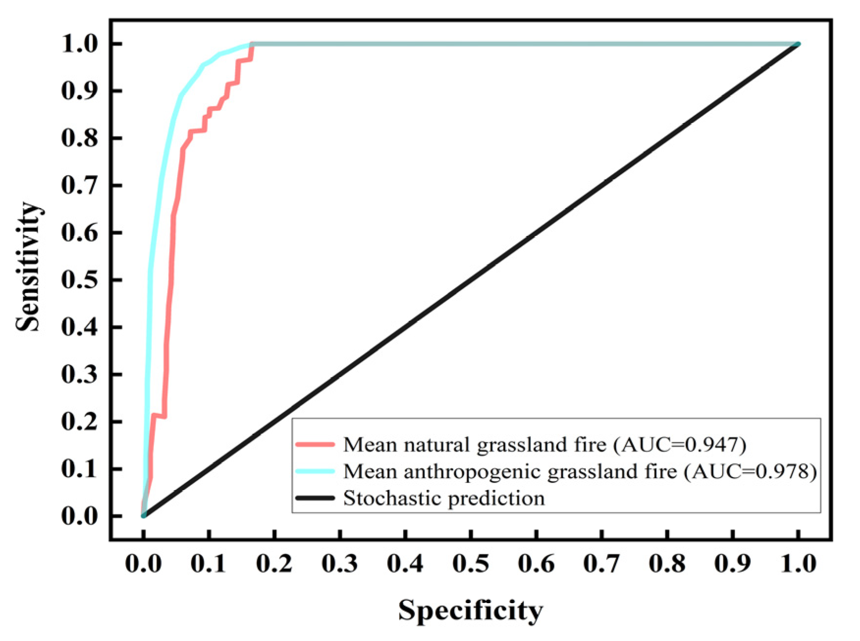
The model simulated natural grassland fire susceptibility with an AUC of 0.947 (±0.024) and anthropogenic grassland fire susceptibility with an AUC of 0.978 (±0.002). The high-susceptibility zones had G values of 0.87 and 0.92, respectively. The model demonstrated high precision, reliability, and accuracy, making it suitable for evaluating grassland fire susceptibility in Qinghai Province.
(2)
Grassland fire susceptibility in Qinghai Province exhibits clear regional and geographical characteristics. High-susceptibility areas for natural grassland fires are primarily located in the southern region, encompassing most of Guoluo Tibetan Autonomous Prefecture, Zeku County in Hainan Tibetan Autonomous Prefecture, Henan Mongolian Autonomous County, and Yushu City in Yushu Tibetan Autonomous Prefecture. Conversely, high-susceptibility areas for anthropogenic grassland fires are found in the eastern parts of Huangnan Tibetan Autonomous Prefecture, Haidong City, and eastern Hainan and Haibei Tibetan Autonomous Prefectures, where the intensity of human activities is high and settlements are prevalent.
(3)
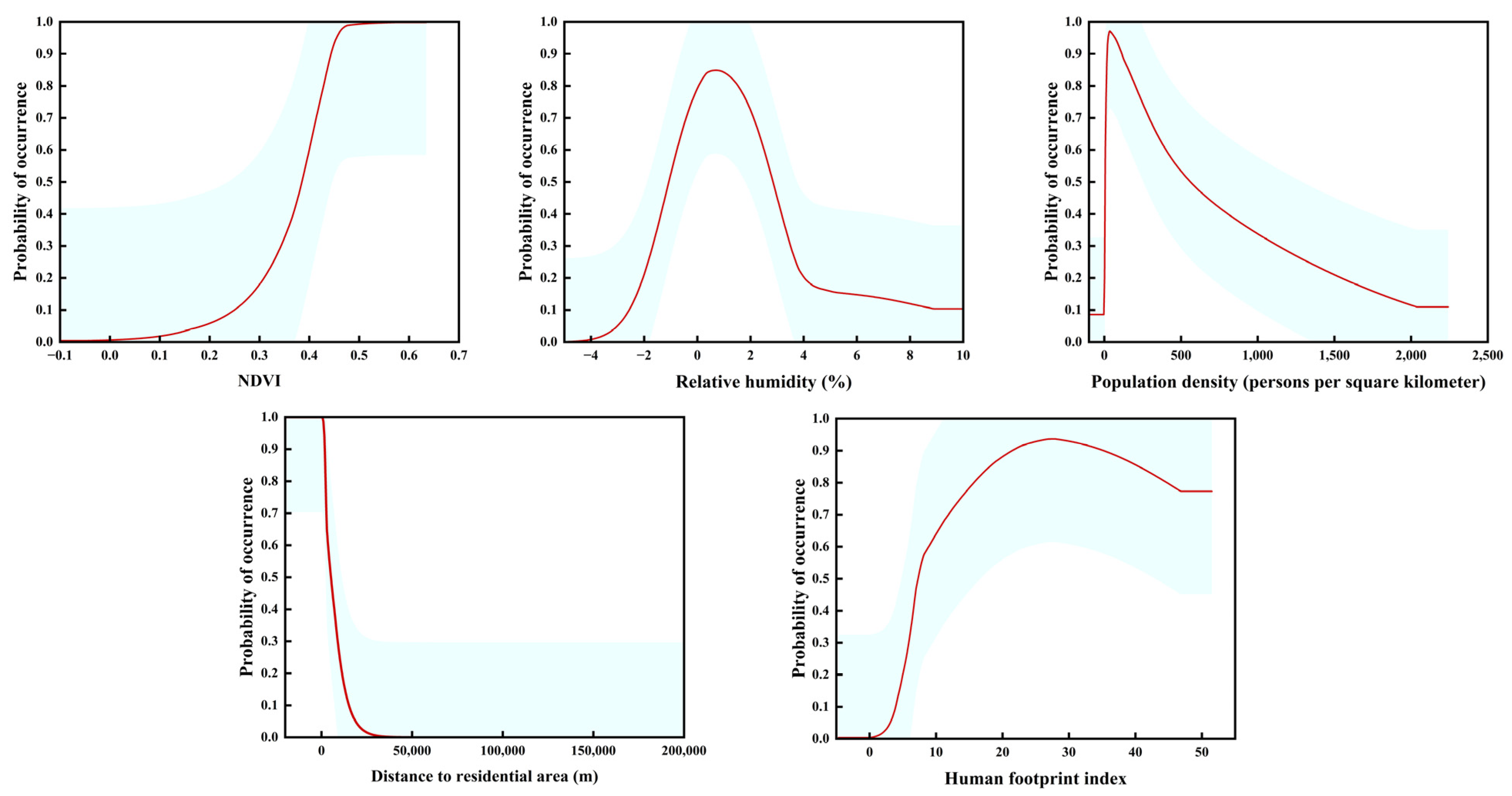
The influencing factors for natural grassland fire susceptibility include distance to rivers, vegetation type, multi-year average precipitation, and average wind speed. For anthropogenic grassland fire susceptibility, the key influencing factors are NDVI, relative humidity, population density, distance to settlements, and the human footprint index. Additionally, water sources and combustible loads act as accelerators for natural grassland fire occurrences, whereas human activities serve as an accelerating factor for anthropogenic grassland fires.
(4)
Among the grassland fires with identified causes, natural fires were predominantly caused by spontaneous combustion, accounting for 6.67%. Fires attributed to human activities accounted for 93.33%, with high-voltage-line contact, heating during grazing, and firecrackers being the primary causes.

5.2. Outlook

Global climate change presents significant challenges to the study of grassland fires. It is essential to continuously enhance the analysis and monitoring of factors influencing these fires while promoting multidisciplinary integration and interdisciplinary research to optimize resource allocation. Currently, the majority of scholars in China focus on grassland fire studies in the Inner Mongolia Plateau, with insufficient attention directed towards the Qinghai–Tibetan Plateau. Grassland fires exhibit spatial heterogeneity characterized by markedly different conditions for fire initiation, patterns, and characteristics. This variability complicates the effective management of grassland fires on the Tibetan Plateau and throughout China, thereby hindering governmental prevention and control efforts as well as ecological protection research and development.
In light of the characteristics of grassland fires in Qinghai Province, several recommendations are proposed: By conducting precise fire risk assessments, financial institutions and insurance companies can optimize insurance pricing, develop catastrophe bonds, and foster growth in the reinsurance market. Governments and relevant organizations can also leverage these data to establish policy-driven insurance mechanisms aimed at strengthening the resilience of grassland ecosystems. We also propose establishing a specialized grassland monitoring system for the Qinghai–Tibetan Plateau to facilitate effective disaster data sharing; improving the monitoring and early warning mechanisms in high-risk regions and during peak fire months; integrating early warning systems with community-led preventive strategies as a fundamental approach for fire detection, reduction, and control; and conducting regional studies on the patterns and characteristics of natural grassland fires across the Qinghai–Tibetan Plateau, incorporating insights from spontaneous peat fires in the Arctic Circle, which exhibit similar combustion dynamics. Currently, grassland fires occur frequently on the Tibetan Plateau, and thorough risk assessment and monitoring could offer valuable support for governmental decision-making. Spontaneous peat fires near the Arctic Circle show similarities with spontaneous grassland fires on the Tibetan Plateau, profoundly impacting the carbon cycle, secondary disasters, and ecological stability. Therefore, research on grassland fires on the Tibetan Plateau, particularly those involving spontaneous combustion, is essential. Analyzing the influencing factors and identifying high-risk areas with high fire incidence and susceptibility are critical steps toward strengthening regional grassland fire risk management capacity and effectiveness.

Author Contributions

Writing—original draft preparation, W.X.; conception and writing—review and editing, Q.Z.; writing—review and editing, methodology, W.M.; collection of data, Y.H. All authors have read and agreed to the published version of the manuscript.

Funding

This study was supported by the Qinghai Provincial Key R&D and Transformation Program for the Transformation of Scientific and Technological Achievements Special Project, China, under Grant (number 2023-SF-109).

Institutional Review Board Statement

Not applicable.

Informed Consent Statement

Not applicable.

Data Availability Statement

The data presented in this study are available upon request from the corresponding author. The data are not publicly available due to privacy.

Acknowledgments

We are very grateful to the academic editors and reviewers for their valuable suggestions, as well as to the subject students for their contributions in data collection.

Conflicts of Interest

The authors declare no conflicts of interest.

References

  1. Bowman, D.M.J.S.; Kolden, C.A.; Abatzoglou, J.T.; Johnston, F.H.; van der Werf, G.R.; Flannigan, M. Vegetation fires in the Anthropocene. Nat. Rev. Earth Environ. 2020, 1, 500–515. [Google Scholar] [CrossRef]
  2. Keith, D.A.; Ferrer-Paris, J.R.; Nicholson, E.; Bishop, M.J.; Polidoro, B.A.; Ramirez-Llodra, E.; Tozer, M.G.; Nel, J.L.; Mac Nally, R.; Gregr, E.J.; et al. A function-based typology for Earth’s ecosystems. Nature 2022, 610, 513–518. [Google Scholar] [CrossRef] [PubMed]
  3. Pausas, J.G.; Bond, W.J. On the Three Major Recycling Pathways in Terrestrial Ecosystems. Trends Ecol. Evol. 2020, 35, 767–775. [Google Scholar] [CrossRef] [PubMed]
  4. Wang, B.; Zhang, J.; Meng, M.; Zhang, Q. Study on vegetation restoration characteristics of daxing’anling Burned area based on EVI. For. Sci. Res. 2021, 34, 32–41. [Google Scholar] [CrossRef]
  5. Sonnier, G.; Boughton, E.H.; Whittington, R. Long-term response of wetland plant communities to management intensity, grazing abandonment, and prescribed fire. Ecol. Appl. 2023, 33, e2732. [Google Scholar] [CrossRef]
  6. Tan, N.; Alatengtuya; Bao, Y.; Gao, Y.; Aorigele. Spatiotemporal evolution characteristics of high-frequency Grassland fire Area in Mongolian plateau based on a space-time cube. Pratacultural Sci. 2023, 40, 2763–2774. [Google Scholar] [CrossRef]
  7. Zhang, J.; Shen, L.; Tong, Z.; Liu, X.; Liang, C. Spatial Prediction of Human-caused Grassland Fire Risk in Hulunbeier Region Based on Weights of Evidence. J. Nat. Disasters 2012, 21, 99–107. [Google Scholar] [CrossRef]
  8. Zhou, H.; Wang, Y.; Zhou, G. Temporal and Spatial Dynamics of Grassland Fires in Lnmer Mongolia. Acta Prataculturae Sin. 2016, 25, 16–25. [Google Scholar] [CrossRef]
  9. Jin, Q.; Ma, X.; Wang, W.; Yang, X.; Guo, F. Temporal and Spatial Characteristics of Particulate Matter Emission from Forest Fires in Subtropical China during 2000–2014. Acta Sci. Circumstantiae 2017, 37, 2238–2247. [Google Scholar] [CrossRef]
  10. Jin, Q.; Chen, L.; Huang, J.; Jia, D. Influence of Indoor Formaldehyde on Physiological and Biochemical Characteristics of Dracaena Sanderiana. Environ. Sci. Technol. 2016, 39, 45–50. [Google Scholar] [CrossRef]
  11. Thomas, M.A.; Lindsay, D.N.; Cavagnaro, D.B.; Kean, J.W.; McCoy, S.W.; Graber, A.P. The rainfall intensity-duration control of debris flows after wildfire. Geophys. Res. Lett. 2023, 50, e2023GL103645. [Google Scholar] [CrossRef]
  12. Page, S.E.; Siegert, F.; Rieley, J.O.; Boehm, H.-D.V.; Jaya, A.; Limin, S. The amount of carbon released from peat and forest fires in Indonesia during 1997. Nature 2002, 420, 61–65. [Google Scholar] [CrossRef] [PubMed]
  13. Zhu, M. Design and Experimental Study of a Lidar System for Detecting Initial Fires in the Field. Master’s Thesis, Xi’an University of Technology, Xi’an, China, 2024. [Google Scholar]
  14. Turetsky, M.R.; Benscoter, B.; Page, S.; Rein, G.; van der Werf, G.R.; Watts, A. Global vulnerability of peatlands to fire and carbon loss. Nat. Geosci. 2015, 8, 11–14. [Google Scholar] [CrossRef]
  15. Stracher, G.B.; Prakash, A.; Rein, G. Coal and Peat Fires: A Global Perspective, 1st ed.; Elsevier: Amsterdam, The Netherlands, 2015; Volume 4, pp. 1–11. [Google Scholar] [CrossRef]
  16. Brazhnik, K.; Hanley, C.; Shugart, H.H. Simulating changes in fires and ecology of the 21st century Eurasian boreal forests of Siberia. Forests 2017, 8, 49. [Google Scholar] [CrossRef]
  17. Liu, Z.; Wimberly, M.C. Direct and indirect effects of climate change on projected future fire regimes in the western United States. Sci. Total Environ. 2016, 542, 65–75. [Google Scholar] [CrossRef] [PubMed]
  18. McCarty, J.L.; Aalto, J.; Paunu, V.-V.; Arnold, S.R.; Eckhardt, S.; Klimont, Z.; Fain, J.J.; Evangeliou, N.; Venäläinen, A.; Tchebakova, N.M. Reviews & syntheses: Arctic fire regimes and emissions in the 21st century. Biogeosciences 2021, 18, 5053–5083. [Google Scholar] [CrossRef]
  19. Running, S.W. Is global warming causing more, larger wildfires? Science 2006, 313, 927–928. [Google Scholar] [CrossRef]
  20. Irannezhad, M.; Liu, J.; Ahmadi, B.; Chen, D. The dangers of Arctic zombie wildfires. Science 2020, 369, 1171. [Google Scholar] [CrossRef]
  21. Luo, B.; Luo, D.; Dai, A.; Xiao, C.; Simmonds, I.; Hanna, E.; Overland, J.; Shi, J.; Chen, X.; Yao, Y. Rapid summer Russian Arctic sea-ice loss enhances the risk of recent Eastern Siberian wildfires. Nat. Commun. 2024, 15, 5399. [Google Scholar] [CrossRef]
  22. Robinson, S.D.; Moore, T.R. The influence of permafrost and fire upon carbon accumulation in high boreal peatlands, Northwest Territories, Canada. Arct. Antarct. Alp. Res. 2000, 32, 155–166. [Google Scholar] [CrossRef]
  23. Liu, X.; Zhang, J.; Fan, J. Historical data-based risk assessment of fire in grassland of northen China. J. Nat. Disasters 2007, 22, 61–65. [Google Scholar]
  24. Zhang, J.; Liu, X.; Tong, Z. The study of grassland fire disaster risk assessment and regionalization: A case study in the western Jilin Province. Geogr. Res. 2007, 26, 755–762. [Google Scholar]
  25. Jiao, M.; Quan, X.; He, B.; Yao, J. Remote sensing-based spatial-temporal characteristics of forest grassland fires in Sichuan Province from 2001 to 2021. Natl. Remote Sens. Bull. 2024, 28, 2984–3001. [Google Scholar] [CrossRef]
  26. Ramo, R.; Roteta, E.; Bistinas, I.; van Wees, D.; Bastarrika, A.; Chuvieco, E.; van der Werf, G.R. African burned area and fire carbon emissions are strongly impacted by small fires undetected by coarse resolution satellite data. Proc. Natl. Acad. Sci. USA 2021, 118, 7. [Google Scholar] [CrossRef]
  27. Zhou, F.; Guo, M.; Zhong, C.; Chang, Y.; Yu, F. Spatial-temporal Patterns and Characteristics of GrasslandFire in the Hulunbuir Grassland. Geogr. Sci. 2022, 42, 1838–1847. [Google Scholar] [CrossRef]
  28. Zapata-Ríos, X.; Lopez-Fabara, C.; Navarrete, A.; Torres-Paguay, S.; Flores, M. Spatiotemporal patterns of burned areas, fire drivers, and fire probability across the equatorial Andes. J. Mt. Sci. 2021, 18, 952–972. [Google Scholar] [CrossRef]
  29. Ji, Q.; Ju, Y.; Yang, X.; Wang, W.; Guo, F. Temporal and spatial patterns of emissions and pollutants from grassland burned in Inner Mongolia during 2005–2014. Acta Prataculturae Sin. 2017, 26, 21–29. [Google Scholar]
  30. Cruz, M.G.; Sullivan, A.L.; Gould, J.S.; Hurley, R.J.; Plucinski, M.P. Got to burn to learn: The effect of fuel load on grassland fire behaviour and its management implications. Int. J. Wildland Fire 2018, 27, 727–741. [Google Scholar] [CrossRef]
  31. Jaafari, A.; Zenner, E.K.; Panahi, M.; Shahabi, H. Hybrid artificial intelligence models based on a neuro-fuzzy system and metaheuristic optimization algorithms for spatial prediction of wildfire probability. Agric. For. Meteorol. 2019, 266, 198–207. [Google Scholar] [CrossRef]
  32. Wang, Z.; Huang, R.; Yao, Q.; Zong, X.; Tian, X.; Zheng, B.; Trouet, V. Strong winds drive grassland fires in China. Environ. Res. Lett. 2023, 18, 015005. [Google Scholar] [CrossRef]
  33. Wei, Y.; Sun, J.; Yuan, Q. Temporal and Spatial Distribution of Grassland Fires in Heilongjiang Province. For. Sci. Technol. 2023, 48, 50–54. [Google Scholar] [CrossRef]
  34. Huang, Y.; Xia, X.; Zhou, Q.; Pan, Y.; Chen, Y.; Li, H. Spatial and Temporal Patterns and Causes of Grassland Fires in Qinghai Province. Prog. Geogr. 2023, 42, 1973–1983. [Google Scholar] [CrossRef]
  35. Li, N.; Bao, Y.L.; Yin, S.; Na, R.S. Spatiotemporal Characteristics of Grassland Fire in China-Mongolia Border Regions. J. Catastrophology 2016, 31, 207–210. [Google Scholar]
  36. Zhang, X. Vegetation Map of the People’s Republic of China (1:1 000 000); Institute of Botany, Chinese Academy of Sciences: Beijing, China, 2007. [Google Scholar] [CrossRef]
  37. Phillips, S.J.; Anderson, R.P.; Schapire, R.E. Maximum entropy modeling of species geographic distributions. Ecol. Model. 2006, 190, 231–259. [Google Scholar] [CrossRef]
  38. Liu, S.; Yang, J. Modeling Spatial Patterns of Forest Fire in Heilongjiang Province Using Generalized Linear. Chin. J. Ecol. 2013, 32, 1620–1628. [Google Scholar] [CrossRef]
  39. Qu, X.; Li, D.a.; He, Y.; Yu, L.; Yan, W. Evaluation of Landslide Susceptibility Based on Maxent Model—Taking Panzhihua City as an Example. Soil Water Conserv. Res. 2021, 28, 224–229. [Google Scholar] [CrossRef]
  40. Tang, X.; Wang, H.; Huang, D.; Zhang, J. Evaluation of Landslide Susceptibility in Middle and Lower Reaches of Yangtze River—Taking Jiangxi Province as a Case Study. Soil Water Conserv. Bull. 2021, 41, 166–172. [Google Scholar] [CrossRef]
  41. Chen, W.; Pourghasemi, H.R.; Kornejady, A.; Zhang, N. Landslide spatial modeling: Introducing new ensembles of ANN, MaxEnt, and SVM machine learning techniques. Geoderma 2017, 305, 314–327. [Google Scholar] [CrossRef]
  42. Thiery, Y.; Malet, J.-P.; Sterlacchini, S.; Puissant, A.; Maquaire, O. Landslide susceptibility assessment by bivariate methods at large scales: Application to a complex mountainous environment. Geomorphology 2007, 92, 38–59. [Google Scholar] [CrossRef]
  43. Graham, C.H.; Elith, J.; Hijmans, R.J.; Guisan, A.; Peterson, A.T.; Loiselle, B.A. The Influence of Spatial Errors in Species Occurrence Data Used in Distribution Models. J. Appl. Ecol. 2008, 45, 239–247. [Google Scholar] [CrossRef]
  44. Xu, W.; Luo, C. Application of MAXENT Model in Rhinopithecus Roxllanae Habitat Assessment in Qinling Mountain. For. Eng. 2010, 26, 1–3+26. [Google Scholar] [CrossRef]
  45. Lobo, J.M.; Jiménez-Valverde, A.; Real, R. AUC: A misleading measure of the performance of predictive distribution models. Glob. Ecol. Biogeogr. 2008, 17, 145–151. [Google Scholar] [CrossRef]
  46. Qiao, W.; Bi, S.; Wang, Q.; Guo, Y. Predictive Model of Archaeological Sites of Longshan Culture in Zhengzhou-luoyang Area. Surv. Mapp. Sci. 2013, 38, 172–174+181. [Google Scholar] [CrossRef]
  47. Wu, R.; Gan, S.; Yu, L.; Zhu, J.; Liu, F. The Study of Predictive Distribution of Pakistani Sites Based on Maxent Model. Surv. Mapp. Sci. 2021, 46, 96–103. [Google Scholar] [CrossRef]
  48. He, L. Effects of Temperature and Water Level Changes on Enzyme Activities in North Peatlands: A Case Study in Xiao’Xing’An’Ling Mountain. Master’s Thesis, China University of Geosciences, Wuhan, China, 2010. [Google Scholar]
  49. Bertschi, I.; Yokelson, R.J.; Ward, D.E.; Babbitt, R.E.; Susott, R.A.; Goode, J.G.; Hao, W.M. Trace gas and particle emissions from fires in large diameter and belowground biomass fuels. J. Geophys. Res. Atmos. 2003, 108, 8472. [Google Scholar] [CrossRef]
  50. Zeng, S.; Zhang, T. Analysis on the Current Situation and Protection Countermeasures of Maidika Wetland in Xizang. Compr. Util. Resour. China 2023, 41, 139–141. [Google Scholar] [CrossRef]
  51. Huang, X.; Lin, S.; Liu, N. A Review of Smoldering Wildfire:Research Advances and Prospects. J. Eng. Thermophys. 2021, 42, 512–528. [Google Scholar]
  52. Reardon, J.; Curcio, G.; Bartlette, R. Soil moisture dynamics and smoldering combustion limits of pocosin soils in North Carolina, USA. Int. J. Wildland Fire 2009, 18, 326–335. [Google Scholar] [CrossRef]
  53. Shu, L.; Wang, M.; Tian, X.; Li, Z.; Xiao, Y. Fire environment mechanism of ground fire formation in Daxing’an Mountains. J. Nat. Disasters 2003, 12, 62–67. [Google Scholar]
  54. Tacconi, L.; Moore, P.F.; Kaimowitz, D. Fires in tropical forests—What is really the problem? lessons from Indonesia. Mitig. Adapt. Strateg. Glob. Change 2007, 12, 55–66. [Google Scholar] [CrossRef]
  55. Frandsen, W.H. Ignition probability of organic soils. Can. J. For. Res. 1997, 27, 1471–1477. [Google Scholar] [CrossRef]
  56. Garlough, E.C.; Keyes, C.R. Influences of moisture content, mineral content and bulk density on smouldering combustion of ponderosa pine duff mounds. Int. J. Wildland Fire 2011, 20, 589–596. [Google Scholar] [CrossRef]
  57. Reardon, J.; Curcio, G. Estimated smoldering probability: A new tool for predicting ground fire in the organic soils on the North Carolina Coastal Plain. Fire Manag. Today 2011, 4, 95–104. [Google Scholar]
  58. Benscoter, B.W.; Vitt, D.H. Spatial Patterns and Temporal Trajectories of the Bog Ground Layer Along a Post-Fire Chronosequence. Ecosystems 2008, 11, 1054–1064. [Google Scholar] [CrossRef]
  59. Turetsky, M.R. Decomposition and organic matter quality in continental peatlands: The ghost of permafrost past. Ecosystems 2004, 7, 740–750. [Google Scholar] [CrossRef]
  60. Xu, Y.; Qian, Y.; Da, H.; Li, B.; Guan, Q. Forest and Grassland Fire Risk Prediction and Early Warning Service in Qinghai Province. Adv. Meteorol. Sci. Technol. 2023, 13, 107–110. [Google Scholar]
  61. Liu, Y. Study on the Causes of Grassland Fires in Gannan Area and Fire Prevention and Extinguishing Measures. Guangdong Seric. 2024, 58, 40–42. [Google Scholar] [CrossRef]
  62. Zhou, F. The Study of Spatio-Temporal Pattern Andinfluencing Factors of Fires in Hulunbuir Grassland. Master’s Thesis, Northeast Normal University, Changchun, China, 2023. [Google Scholar]
  63. Li, Z.; Fraser, R.; Jin, J.; Abuelgasim, A.A.; Csiszar, I.; Gong, P.; Pu, R.; Hao, W. Evaluation of satellite-based algorithms for fire detection and mapping within North America. J. Geophys. Res. 2003, 108, 4076. [Google Scholar]
  64. Feng, Z. Spatiotemporal Changes of Grassland Fire in InnerMongolia in Recent 30 Years. Master’s Thesis, Inner Mongolia Normal University, Hohhot, China, 2015. [Google Scholar]
  65. Liu, M.; Jiao, J.; Pan, J.; Song, J.; Che, Y.; Li, L. Spatial and temporal patterns of planting NPP and its driving factors in Qinghai Province. Acta Ecol. Sin. 2020, 40, 5306–5317. [Google Scholar]
Figure 1. Vegetation type map of Qinghai Province.
Applsci 15 03386 g001
Figure 2. ROC curve for grassland fires.
Applsci 15 03386 g002
Figure 3. Distribution of natural grassland fire (a) and anthropogenic grassland fire (b) susceptibility in Qinghai province.
Applsci 15 03386 g003
Figure 4. Response curves of key influence factors for natural grassland fires.
Applsci 15 03386 g004
Figure 5. Anthropogenic grassland fire key influencing factor response curves.
Applsci 15 03386 g005
Figure 6. Spontaneous combustion process of underground grassland fires in Qinghai Province.
Applsci 15 03386 g006
Table 1. Influence factors of grassland fires in Qinghai Province.
Factor DescriptionUnit of Measure
Average Multi-year Precipitationmm
Average Annual Temperature°C
Average Annual Wind Speedm/s
Normalized Difference Vegetation Index
Height Above Sea Levelm
Elevation°
Slope Aspect
Relative Humidity%
Vegetation Type
Distance to Riversm
Human Footprint Index
Distance to Roadsm
Distance from Settlementsm
Population DensityPersons/km2
Table 2. Grassland fire spontaneous combustion process gain statistics of grassland fire susceptibility evaluation model in Qinghai Province.
TypologyHierarchyArea Proportion (%)Fire points Proportion (%)G
Natural grassland fireUpper Hierarchy8.98700.87
Middle Hierarchy36.6330−0.22
Lower Hierarchy54.3901
Anthropogenic grasslandUpper Hierarchy7.8295.350.92
Middle Hierarchy10.114.65−1.17
Lower Hierarchy82.0701
Table 3. Contribution of influence factors to the MaxEnt model.
Impact FactorContribution (%)
Distance to river33.6
Vegetation type23.4
Average multi-year precipitation16.9
Average annual wind speed13
Elevation7.5
Slope direction4.7
Relative humidity1
Table 4. Contribution of influence factors to the MaxEnt model.
Impact FactorContribution (%)
NDVI23.4
Relative humidity20.5
Population density16.1
Distance to populated areas16
Human footprint index15.2
Elevation4.8
Slope direction2.7
Average multi-year precipitation0.7
Distance to rivers0.4
Distance to roads0.3
Disclaimer/Publisher’s Note: The statements, opinions and data contained in all publications are solely those of the individual author(s) and contributor(s) and not of MDPI and/or the editor(s). MDPI and/or the editor(s) disclaim responsibility for any injury to people or property resulting from any ideas, methods, instructions or products referred to in the content.

