
Research on the Cultural Landscape Features and Regional Variations of Traditional Villages and Dwellings in Multicultural Blending Areas: A Case Study of the Jiangxi-Anhui Junction Region


Abstract
1. Introduction
2. Materials and Methods
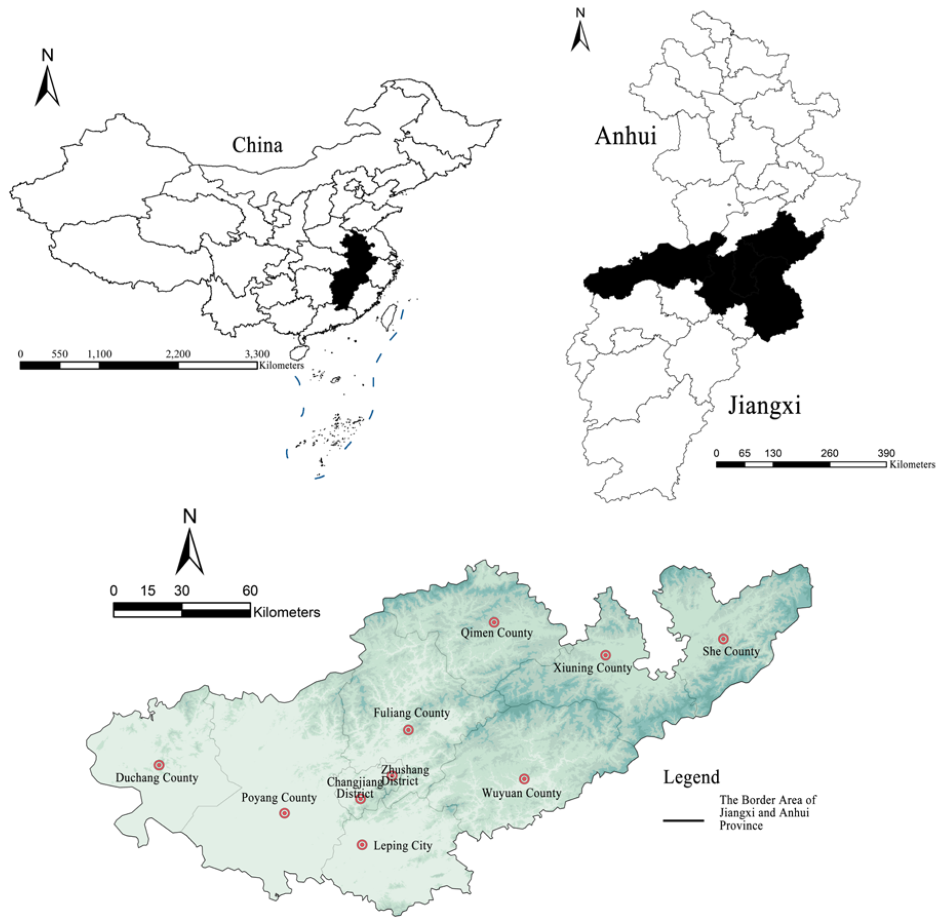
2.1. Delineation of the Study Area
2.2. Characterization of the Study Area
2.2.1. Physical Geography: Mountain Ranges and River Connections
2.2.2. Cultural District Location: Gan Cultural and Hui Cultural Intermingling Area
2.3. Study Object
2.4. Data Source
2.5. Research Methodology
2.5.1. Deconstruction of Cultural Landscape
2.5.2. ArcGIS Spatial Analysis Method
2.5.3. Principal Component Analysis
- (1)
- Calculate the eigenvalues of the correlation coefficient matrix R:
- (2)
- Determine the number of principal components, m so that the extraction rate of principal component factor information reaches more than 80%:
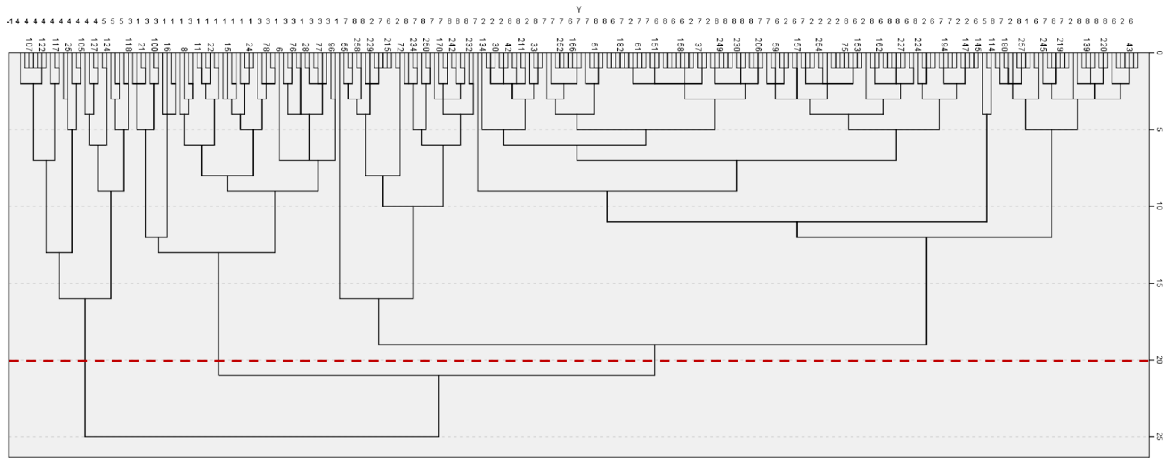
2.5.4. Systematic Cluster Analysis
2.6. Overview of Research Methodology
3. Traditional Villages and Dwellings Cultural Landscape Zoning Analysis
3.1. Selection of Cultural Landscape Factors and System Construction
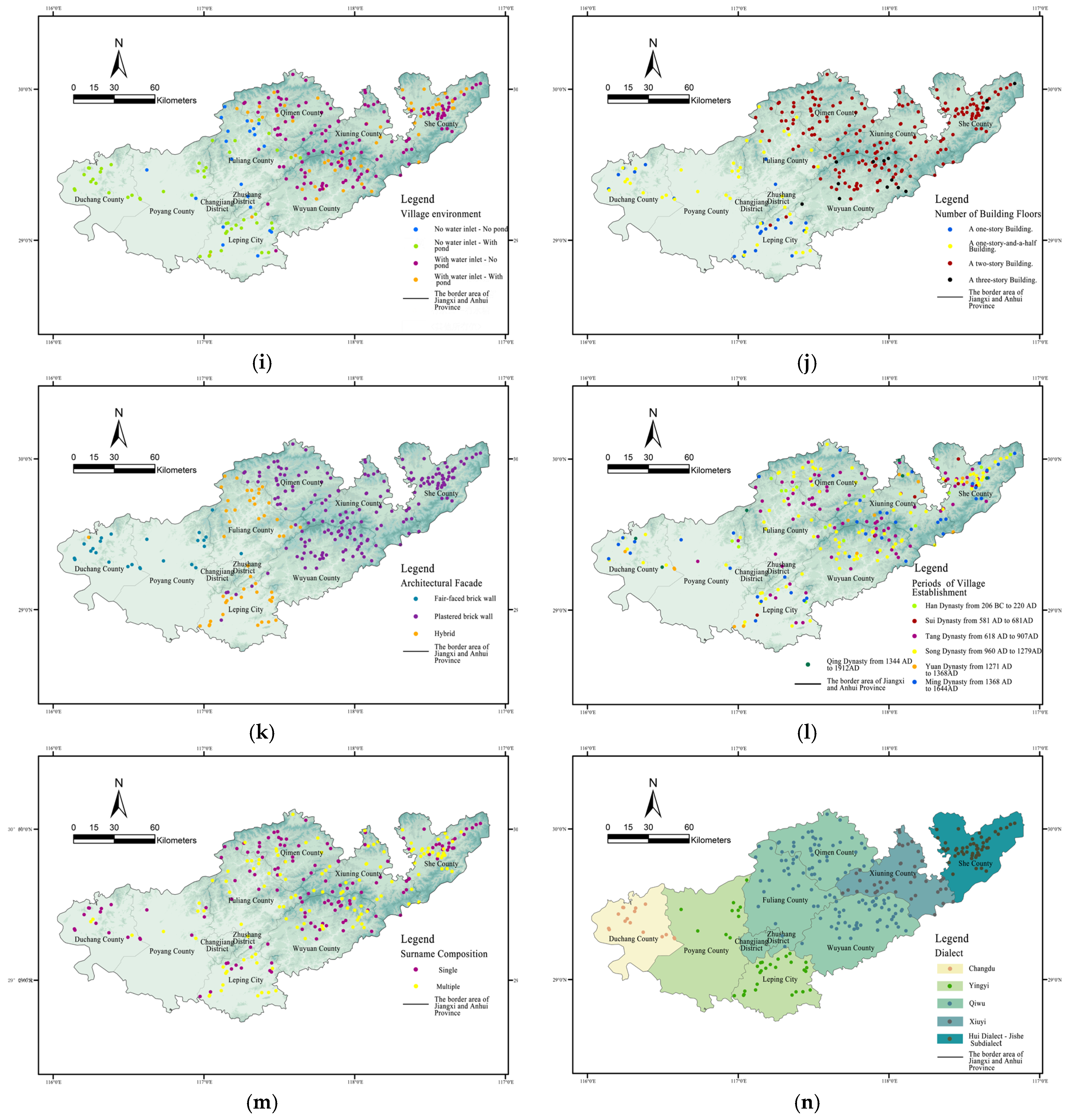
3.2. Characteristics of Spatial Distribution of Data-Driven Cultural Landscape Factors
3.3. Principal Component Analysis of Data-Driven Cultural Landscape Factors
3.3.1. Model Testing
3.3.2. Determination of Principal Components
3.4. Cluster Analysis of Data-Driven Cultural Landscape Factor Systems
4. Results
4.1. Typical Characteristics of Traditional Villages and Residential Cultural Landscape Areas in the Border Region of Jiangxi and Anhui Provinces
4.1.1. Characteristics of Water Culture-Dominated Traditional Village Cultural Landscape Area in the Western Plains
4.1.2. Characteristics of Multi-Cultural Symbiosis Traditional Village Cultural Landscape Area in the Central Hilly Plains
4.1.3. Characteristics of Clan Culture-Dominant Traditional Village Cultural Landscape Area in the Eastern Hilly Mountainous
4.2. Traditional Villages and Dwellings Cultural Landscapes in the Jiangxi-Anhui Junction Region
4.2.1. Zonal Differentiation of Village Sites
4.2.2. Zonal Differentiation of Settlement Patterns
4.2.3. Zonal Differentiation of Architectural Aesthetics
4.3. Mechanisms of Formation for Traditional Villages and Distinctions in Dwellings and Cultural Landscapes
4.3.1. Endogenous Dynamics: Natural Geographic Environment
4.3.2. Exogenous Dynamics: The Social and Human Environment
- Regional Culture as a Spiritual Guiding Mechanism
- 2.
- Historical Migration and the Sequence of Regional Development as Mutation Mechanisms
- 3.
- Commercial trade development as a promotion mechanism
- 4.
- Changes in Institutional History
5. Discussion
5.1. Methodological Validation and Application as a Reference for Other Multicultural Regions
5.2. Scientific Guidance for China’s Rural Revitalization Strategy
5.3. Providing Scientific Guidance for the Conservation and Sustainable Development of the World’s Cultural Heritage
5.4. Limitations and Future Prospects
6. Conclusions
Author Contributions
Funding
Institutional Review Board Statement
Informed Consent Statement
Data Availability Statement
Acknowledgments
Conflicts of Interest
References
- De Blij, H.J. Human Geography: Culture, Society, and Space, 4th ed.; Wiley: New York, NY, USA, 1993; p. 225. [Google Scholar]
- Situ, S. Cultural Geography of Guangdong, 3rd ed.; Guangdong People’s Publishing House: Guangzhou, China, 2013; p. 114. [Google Scholar]
- Antrop, M. Landscape change and the urbanization process in Europe. Landsc. Urban Plan. 2004, 67, 9–26. [Google Scholar] [CrossRef]
- Iwata, Y.; Fukamachi, K.; Morimoto, Y. Public perception of the cultural value of Satoyama landscape types in Japan. Landsc. Ecol. Eng. 2011, 7, 173–184. [Google Scholar] [CrossRef]
- Taylor, K. New Lives, New Landscapes. Landscape, Heritage and Rural Revitalisation: Whose Cultural Values? Built. Herit. 2019, 3, 50–63. [Google Scholar] [CrossRef]
- Fagerholm, N.; Eilola, S.; Kisanga, D.; Arki, V.; Käyhkö, N. Place-based landscape services and potential of participatory spatial planning in multifunctional rural landscapes in Southern highlands, Tanzania. Landsc. Ecol. 2019, 34, 1769–1787. [Google Scholar] [CrossRef]
- Wang, X. Artificial intelligence in the protection and inheritance of cultural landscape heritage in traditional village. Sci. Program. 2022, 2022, 9117981. [Google Scholar] [CrossRef]
- Cloke, P. Country backwater to virtual village? Rural studies and ‘the cultural turn. J. Rural Stud. 1997, 13, 367–375. [Google Scholar] [CrossRef]
- Liu, P.; Liu, C.; Deng, Y.; Shen, X.; Li, B. Research on the Zoning of Traditional Settlement Landscapes and Identification of Landscape Gene Elements in China. Acta Geogr. Sin. 2010, 65, 1496–1506. [Google Scholar]
- Antrop, M. Sustainable landscapes: Contradiction, fiction or utopia? Landsc. Urban Plan. 2006, 75, 187–197. [Google Scholar] [CrossRef]
- Wang, J.; Sun, Q.; Zou, L. Spatial-temporal evolution and driving mechanism of rural production-living-ecological space in Pingtan islands, China. Habitat Int. 2023, 137, 102833. [Google Scholar] [CrossRef]
- Liu, Y.; Zhang, X.; Xu, M.; Zhang, X.; Shan, B.; Wang, A. Spatial patterns and driving factors of rural population loss under urban–rural integration development: A micro-scale study on the village level in a hilly region. Land 2022, 11, 99. [Google Scholar] [CrossRef]
- Zhao, X.; Xue, P.; Wang, F.; Qin, Y.; Duan, X.; Yang, Z. How to become one? The modern bond of traditional villages in centralized contiguous protection and utilization areas in China. Habitat Int. 2024, 145, 103018. [Google Scholar] [CrossRef]
- Wang, W.; Shi, Q.; Wang, G. Analysis of Performance and Genetic Characteristics of Cultural Landscapes in Traditional Villages along the Jinzhong Section of the Wanli Tea Road from a Landscape Gene Information Chain Perspective: A Case Study of Xiamen Village. Sustainability 2024, 16, 8131. [Google Scholar] [CrossRef]
- Wang, F.; Yu, F.; Zhu, X.; Pan, X.; Sun, R.; Cai, H. Disappearing gradually and unconsciously in rural China: Research on the sunken courtyard and the reasons for change in Shanxian County, Henan Province. J. Rural Stud. 2016, 47, 630–649. [Google Scholar] [CrossRef]
- Fang, Y.; Liu, J. Cultural landscape evolution of traditional agricultural villages in North China—Case of Qianzhai Village in Shandong Province. Chin. Geogr. Sci. 2008, 18, 308–315. [Google Scholar] [CrossRef]
- Lu, Y.; Ahmad, Y. Heritage Protection Perspective of Sustainable Development of Traditional Villages in Guangxi, China. Sustainability 2023, 15, 3387. [Google Scholar] [CrossRef]
- Ma, H.; Tong, Y. Spatial differentiation of traditional villages using ArcGIS and GeoDa: A case study of Southwest China. Ecol. Inform. 2022, 68, 101416. [Google Scholar] [CrossRef]
- Aono, H. Shin Chiri B; Ninomiya Shoten: Tokyo, Japan, 1979; pp. 48–51. [Google Scholar]
- Sun, Y.; Ou, Q. Research on the traditional zoning, evolution, and integrated conservation of village cultural landscapes based on “production-living-ecology spaces” – A case study of villages in Meicheng, Guangdong, China. Open Geosci. 2021, 13, 1303–1317. [Google Scholar] [CrossRef]
- Wang, L.; Sun, C.; Wang, M.; Xiao, X. Construction and Characterization of Traditional Village Landscape Cultural Genome Atlases: A Case Study in Xupu County, Hunan, China. Sustainability 2024, 16, 9524. [Google Scholar] [CrossRef]
- Zhuo, X.; Xiao, D. A Study on the Regional Differences in the Landscape of Hakka Traditional Villages on the Borders of Jiangxi, Fujian, and Guangdong. Urban Plan. 2023, 47, 110–122+132. [Google Scholar]
- Cao, K.; Liu, Y.; Cao, Y.; Wang, J.; Tian, Y. Construction and characteristic analysis of landscape gene maps of traditional villages along ancient Qin-Shu roads, Western China. Heritage Sci. 2024, 12, 37. [Google Scholar] [CrossRef]
- Liu, P. Research on the Construction and Application of Landscape Genomic Atlas of Traditional Settlements in China. Ph.D. Thesis, Peking University, Beijing, China, 2011. [Google Scholar]
- Wang, X.; Li, S.; Li, L.; Guo, Y.; Liu, J. The representation of regional cultural gene and the concept of spatial control of transgene based on human perspective. Hum. Geogr. 2014, 29, 1–9. [Google Scholar]
- Xiang, H.; Qin, Y.; Xie, M.; Zhou, B. Study on the “space gene” diversity of traditional dong villages in the Southwest Hunan Province of China. Sustainability 2022, 14, 14306. [Google Scholar] [CrossRef]
- Li, B.; Zeng, R.; Liu, P.; Liu, Y.; Dou, Y. Study on the evolution of human settlements in traditional villages based on CAS theory: A case study of Zhang Guying Village. Geogr. Res. 2018, 37, 1982–1996. [Google Scholar]
- Zheng, W.; Deng, Y.; Luo, L.; Liu, P.; Liu, X. Quantitative Evaluation and Zoning of Traditional Settlement Cultural Landscapes in Western Hunan. Hum. Geogr. 2016, 31, 55–60. [Google Scholar]
- Mo, M.; Ye, Y. Characteristics of Jiangxi Regional Culture and Geographical Factors of Its Formation. J. Jiangxi Norm. Univ. (Nat. Sci.) 2004, 29, 555–558. [Google Scholar]
- Luan, C. The Formation and Evolution Process of Huizhou Culture. Anhui Hist. 2014, 58, 109–113+121. [Google Scholar]
- Hou, W. Discussing to comprehensive evaluation by principal component. Appl. Stat. Manag. 2006, 25, 211–214. [Google Scholar]
- Yang, W.; Zhang, T. SPSS Statistical Analysis and Industry Application Case Studies, 4th ed.; Tsinghua University Press: Beijing, China, 2011; p. 158. [Google Scholar]
- Zhou, S.; Kong, X.; Zhu, H. Cultural Geography, 1st ed.; Higher Education Press: Beijing, China, 2004; pp. 226–227. [Google Scholar]
- Shen, X.; Liu, P.; Deng, Y. Landscape Regionalization and Utilization Value of Traditional Settlements in Southern China. Geogr. Res. 2006, 25, 485–494. [Google Scholar]
- Li, J.; Yang, D.; Xiao, D. Regional Differentiation and Formation Mechanism of Cultural Landscapes of Traditional Settlements and Vernacular Dwellings on Hainan Island. Urban Dev. Stud. 2020, 27, 1–8. [Google Scholar]
- Sun, L. Analysis on the Site Selection Pattern of Traditional Villages Influenced by Traditional Feng Shui Culture. Shanxi Archit. 2021, 47, 18–21. [Google Scholar]
- Li, J.; Wang, J.; Li, X. Heritage Value Assessment and Landscape Preservation of Traditional Chinese Villages Based on the Daily Lives of Local Residents: A Study of Tangfang Village in China and the UNESCO HUL Approach. Land 2024, 13, 1535. [Google Scholar] [CrossRef]
- Liu, P. Genetic Expression of Ancient Village Cultural Landscape and Landscape Identification. J. Hengyang Norm. Univ. (Soc. Sci. Ed.) 2003, 24, 1–8. [Google Scholar]
- Han, X.; Zhang, Y.; Sun, F. Method for determining index weight based on principal component analysis. J. Sichuan Ordnance 2012, 33, 124–126. [Google Scholar]
- Liu, R.X.; Kuang, J.; Gong, Q.; Hou, X.L. Principal component regression analysis with SPSS. Comput. Methods Programs Biomed. 2003, 71, 141–147. [Google Scholar] [CrossRef]
- Maitra, S.; Yan, J. Principle component analysis and partial least squares: Two dimension reduction techniques for regression. Appl. Multivar. Statist. Models 2008, 79, 79–90. [Google Scholar]
- Li, F. Principle and Application of Factor Analysis. Ind. Technol. Forum 2014, 13, 76–77. [Google Scholar]
- Duan, Y.; Ni, S.; Liu, J. Comparative Study on the Morphology of Traditional Residences at the Border of Jiangxi and Anhui from the Perspective of Cultural Geography: A Case Study of Ancient Huizhou Wuyuan County and Ancient Raozhou Fugan County. Urban Archit. 2019, 16, 74–76+126. [Google Scholar]
- Shan, W. Research on Village Landscape Design at the Interprovincial Border of Jiangxi and Anhui from the Perspective of Sharing Concept. Master’s Thesis, Jingdezhen Ceramic Institute, Jingdezhen, China, 2022. [Google Scholar]
- Long, H.; Zou, J.; Li, T.; Liu, Y. Evaluation and Regional Typology of Rural Transformation Development: A Case Study of the “Southern Jiangsu-Northern Shaanxi” Belt. Geogr. Res. 2012, 31, 495–506. [Google Scholar]
- Duan, Y.; Guo, Y. A Preliminary Exploration of Quantitative Methods for Studying Traditional Dwelling Morphology: A Case Study of the Border Region Between Jiangxi and Anhui. Archit. Cult. 2020, 17, 77–78. [Google Scholar]
- Liu, B. Basic Concepts and Historical Status of Huizhou Culture. J. Anhui Univ. (Nat. Sci.) 2002, 27, 28–33. [Google Scholar]
- Zhang, X. Northern Immigrants and Economic Development in Huizhou During the Late Tang and Five Dynasties Periods. J. Anhui Norm. Univ. (Humanit. Soc. Sci.) 2006, 51, 687–691. [Google Scholar]
- Xu, Y. A Study on the Landscape of Traditional Villages in Jiangxi Province Influenced by Immigrant Culture. Ph.D. Thesis, Beijing Forestry University, Beijing, China, 2021. [Google Scholar]
- Li, J.; Chu, J.; Ye, J. Spatial Evolution Characteristics and Driving Mechanisms of Ancient Huizhou Traditional Villages. Econ. Geogr. 2018, 38, 153–165. [Google Scholar]
- Zhong, Y.; Tang, L. The Symbiotic Integration of Traditional Dwelling Architectural Forms and Regional Culture: A Case Study of Ming Dynasty Dwellings in Jingdezhen. Sino-Foreign Archit. 2017, 23, 36–38. [Google Scholar]
- Wuyuan County Committee Office. Gazetteer of Placenames in Wuyuan County, Jiangxi Province; Wuyuan County Committee: Shangrao, China, 1985; pp. 1–2. [Google Scholar]
- Boyang County Office. Gazetteer of Placenames in Boyang County, Jiangxi Province; Boyang County Committee: Shangrao, China, 1983; pp. 1–2. [Google Scholar]


| Level | Types of Cultural Landscape Factors | Cultural Landscape Factor Content Classification | Data Source | Data Type |
|---|---|---|---|---|
| Natural Environment | Topography and Geomorphology | Plain; Hill; Mountainous Region; River Valley; Basin; Valley | https://www.gscloud.cn (accessed on 1 December 2024) | Quantitative indicators |
| Elevation | H ≤ 100 m; 101 m~250 m; 251 m~500 m; H ≥ 501 m | |||
| River Flow Pattern Through the Villages | Adjacent River System; River system penetrating through; Surrounding River System; Non-Riverine System. | |||
| Spatial configuration | Settlements Size | Micro ≤ 2 ha; small: 2~5 ha; Medium:5~10 ha; large: 10~20 ha; mega-large ≥ 20 ha. | Field research | |
| Orientation of Settlements | Oriented North-South; Oriented South-North; Oriented West-East; Oriented East-West; Multiple Orientations. | |||
| Settlements Pattern | Compact Block Type; Strip Type; Clustered Type; Stepped Type | Classification; field research based on morphology and typology | ||
| Location Selection for Villages | Completely Surrounded by Mountains; Flatlands Adjacent to Mountains. Nestled in Valleys; Encircled by Water on Three Sides; Backed by Mountainsand Facing Water; Flatlands Along the Water; Surrounded by Ponds | |||
| Street Pattern | Grid Pattern; Branching Pattern; Comb Pattern; Fishbone Pattern; Free-form Pattern. | |||
| Villages Environment | No Water Inlet—No Pond; No Water Inlet—With Pond; With Water Inlet—No Pond; With Water Inlet—With Pond. | |||
| Dwelling typology | Appearance of Dwellings | Fair-faced Brick Wall; Plastered Brick Wall; Hybrid. | ||
| Stories of Dwellings | A one-story Dwelling; A one-story-and-a-half Dwelling; A two-story Dwelling; A three-story Dwelling | |||
| Types of Courtyards | Water-shaped Courtyard; Water-shaped Tiger’s Eye Courtyard; Earth-shaped Courtyard; Earth-shaped Tiger’s Eye Courtyard; Straight-line Courtyard; Straight-line Tiger’s Eye Courtyard. | Field research; Photo documentation and description of records | Descriptive Indica Tors | |
| Roof Types | Double-pitch Roof; Single-pitch Combined With Double-pitch Roof; Double-pitch Roof Interconnected; Composite Roof | |||
| Dwelling Profiles | Overlapping Type; Straight Type; Zigzag Type | |||
| Entrance Forms | Door Canopy Style; Archway Style; Straight-line Style. | |||
| Architectural Decorations | Sculpture/Carving; Ink Painting; Combination; Without Obvious Decoration. | |||
| Historical and Cultural Historical and Cultural | Dominant Cultures | Agricultural Culture, Clan Culture; Water Gate Culture; Academy Culture; Theatre Culture; Merchant Culture, etc. | ||
| Origins of Migration | Henan Province; Zhejiang Province; Shandong Province, etc. | |||
| Periods of Villages Establishment | Han Dynasty; Sui Dynasty; Tang Dynasty; Song Dynasty; Yuan Dynasty; Ming Dynasty; Qing Dynasty. | |||
| Clan structure of Villages | Single-clan settlements; multiple-clan settlements. | |||
| Dialect | Gan Dialect—Changdu Subdialect; Gan Dialect—Yingyi Subdialect; Hui Dialect—Qiwu Subdialect; Hui Dialect—XiuyiSubdialect; Hui Dialect—JisheSubdialect. | Based on language-specific atlases | Quantitative indicators |
| KMO and Bartlett’s Test | ||
|---|---|---|
| KMO Sample Size | 0.775 | |
| Bartlett’s Test of Sphericity | Approximate Chi-Square | 1341.929 |
| Degrees of Freedom | 105 | |
| Significance | 0.000 | |
| Component | Initial Eigenvalues | Extracted Loadings Squared Sum | ||||
|---|---|---|---|---|---|---|
| Total | Percentage of Variance | Cumulative Percentage | Total | Percentage of Variance | Cumulative Percentage | |
| 1 | 7.021 | 50.153 | 50.153 | 7.021 | 50.153 | 50.153 |
| 2 | 2.114 | 15.102 | 65.255 | 2.114 | 15.102 | 65.255 |
| 3 | 1.447 | 10.333 | 75.589 | 1.447 | 10.333 | 75.589 |
| 4 | 1.057 | 7.550 | 83.139 | 1.057 | 7.550 | 83.139 |
| 5 | 0.804 | 5.742 | 88.881 | |||
| 6 | 0.556 | 3.971 | 92.851 | |||
| 7 | 0.387 | 2.766 | 95.617 | |||
| 8 | 0.172 | 1.230 | 96.847 | |||
| 9 | 0.108 | 0.768 | 97.616 | |||
| 10 | 0.097 | 0.692 | 98.307 | |||
| 11 | 0.078 | 0.558 | 98.865 | |||
| 12 | 0.059 | 0.418 | 99.283 | |||
| 13 | 0.054 | 0.383 | 99.666 | |||
| 14 | 0.047 | 0.334 | 100.000 | |||
| Indicator Codes | Cultural Landscape Factors | Principal Components | |||
|---|---|---|---|---|---|
| F1 | F2 | F3 | F4 | ||
| X1 | elevation | 0.868 | −0.229 | −0.204 | −0.030 |
| X2 | topography and geomorphology | 0.825 | −0.308 | −0.051 | 0.010 |
| X3 | river flow pattern through the villages | 0.773 | 0.184 | 0.054 | 0.118 |
| X4 | location selection for villages | −0.745 | 0.257 | 0.245 | −0.049 |
| X5 | settlement size | −0.508 | −0.339 | 0.073 | 0.211 |
| X6 | settlements pattern | 0.370 | −0.285 | 0.281 | 0.021 |
| X7 | orientation of the settlements | 0.044 | 0.674 | −0.148 | 0.063 |
| X8 | street pattern | −0.196 | 0.625 | −0.226 | 0.219 |
| X9 | villages environment | 0.142 | 0.550 | −0.180 | −0.016 |
| X10 | appearance of dwelings | 0.373 | 0.487 | 0.481 | 0.091 |
| X11 | stories of dwellings | −0.190 | −0.168 | 0.716 | −0.012 |
| X12 | periods of villages establishment | 0.489 | 0.451 | 0.505 | 0.103 |
| X13 | clan structure of villages | 0.024 | 0.085 | 0.290 | −0.733 |
| X14 | dialect | −0.061 | −0.220 | 0.258 | 0.621 |
| Cluster Category | Area Codes | Regions |
|---|---|---|
| Category I | 4,5 | Duchang County, Poyang County |
| Category II | 1,3 | Fuliang County, Leping City |
| Category III | 2,6,7,8 | Wuyuan County, Qimen County, Xiuning County, She County |
| Region | Main Cities and Counties | Settlement Pattern | Plan Form of Dwellings | Dialect | |
|---|---|---|---|---|---|
| Zone I | Duchang County, Poyang County | mainly compact block type |  compact block type compact block type |  | Gan dialect-Changdu subdialect, Gan Dialect-Yingyi subdialect |
| Zone II | Fuliang County, Leping City | Mainly compact block type with a Few strip types | 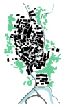 compact block type |  | Gan dialect-Yingyi subdilect, Hui dialect-Qiwu subdialect |
| Zone III | Wuyuan County, Qimen County, Xiuning County, She County | Mainly compact block and strip types with a few stepped types | 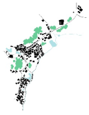 strip type strip type |  | Hui dialect-Qiwu subdialect, Hui dialect-Xiuyisubdialect, Hui dialect-Jixi She subdialect |
| Region | Facade Characteristics | Entrance Forms | Typical Settlement Examples |
|---|---|---|---|
| Zone I | 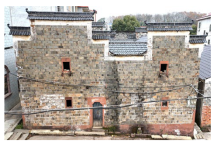 |  |  |
| Shishuwei Village, Duchang County | Heshe Ancient Village, Duchang County | BaishuQinjia Village, Duchang County | |
| Zone II |  | 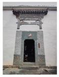 |  |
| Yaoli Town, Fuliang County | Cangxi Village, Fuliang County | Cangxi Village, Fuliang County | |
| Zone III |  | 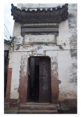 |  |
| Sixi Village, Wuyuan County | Huang Village, Xiuning County | Shangtan Village, Wuyuan County |
Disclaimer/Publisher’s Note: The statements, opinions and data contained in all publications are solely those of the individual author(s) and contributor(s) and not of MDPI and/or the editor(s). MDPI and/or the editor(s) disclaim responsibility for any injury to people or property resulting from any ideas, methods, instructions or products referred to in the content. |
© 2025 by the authors. Licensee MDPI, Basel, Switzerland. This article is an open access article distributed under the terms and conditions of the Creative Commons Attribution (CC BY) license (https://creativecommons.org/licenses/by/4.0/).
Share and Cite
Duan, Y.; Chen, M.; Liu, Y.; Wang, Y.; Zhang, L. Research on the Cultural Landscape Features and Regional Variations of Traditional Villages and Dwellings in Multicultural Blending Areas: A Case Study of the Jiangxi-Anhui Junction Region. Appl. Sci. 2025, 15, 2185. https://doi.org/10.3390/app15042185
Duan Y, Chen M, Liu Y, Wang Y, Zhang L. Research on the Cultural Landscape Features and Regional Variations of Traditional Villages and Dwellings in Multicultural Blending Areas: A Case Study of the Jiangxi-Anhui Junction Region. Applied Sciences. 2025; 15(4):2185. https://doi.org/10.3390/app15042185
Chicago/Turabian StyleDuan, Yapeng, Mingxia Chen, Yue Liu, Yuan Wang, and Li Zhang. 2025. "Research on the Cultural Landscape Features and Regional Variations of Traditional Villages and Dwellings in Multicultural Blending Areas: A Case Study of the Jiangxi-Anhui Junction Region" Applied Sciences 15, no. 4: 2185. https://doi.org/10.3390/app15042185
APA StyleDuan, Y., Chen, M., Liu, Y., Wang, Y., & Zhang, L. (2025). Research on the Cultural Landscape Features and Regional Variations of Traditional Villages and Dwellings in Multicultural Blending Areas: A Case Study of the Jiangxi-Anhui Junction Region. Applied Sciences, 15(4), 2185. https://doi.org/10.3390/app15042185