Article

GIS-Based Analysis of Distribution Patterns and Underlying Motivations of Prehistoric Settlements in the Middle and Lower Yuanjiang River Basin, Central China

1
School of Earth Sciences and Resources, China University of Geosciences, Beijing 100083, China
2
College of Resource Environment and Tourism, Capital Normal University, Beijing 100048, China
*
Authors to whom correspondence should be addressed.
Appl. Sci. 2025, 15(4), 2064; https://doi.org/10.3390/app15042064
Submission received: 2 December 2024 / Revised: 8 January 2025 / Accepted: 5 February 2025 / Published: 16 February 2025

Abstract

:
Exploring prehistoric settlement patterns and their relationship to natural environments is a key focus in geological research, particularly in historically significant regions. The middle and lower reaches of the Yuanjiang River in northwestern Hunan Province are central to the development of early civilizations. Unlike previous studies that focused on individual sites, this research analyzed settlement distribution and migration trends across the entire catchment area. Combining field research with geological, geomorphological, archaeological, remote sensing data, and Geographic Information System techniques, the study revealed a clear pattern: prehistoric settlements increased from higher elevations to lower areas in the east, with concentrations along rivers, especially at river junctions. High floodplains and terraces, offering flat terrain, abundant water, and rich vegetation, were key to supporting early communities. The analysis showed that climate change significantly impacted prehistoric occupations, limiting population growth and stability due to natural disasters. A regional comparison within the Yuanjiang basin indicated that ancient cultures in the downstream area were more similar to those of the Lishui River Basin, while the Wushui cultural group in the middle reaches displayed distinct differences. These findings highlight the complex relationship between geography and cultural development, with the lower reaches being more influenced by climatic fluctuations and natural disasters, especially during the Shijiahe and Shang-Zhou periods. Additionally, the middle reaches of the Yangtze River may have originated in the Xiajiang Area and shifted southward, leading to the rise of cultural centers in the Lishui River Basin. These results emphasize the significance of the Yuanjiang River catchment in Hunan Province in shaping ancient cultures and offer insights for contemporary sustainable practices.

1. Introduction

The relationship between sociocultural environments and natural geographical settings is intricate and interconnected, with human societies and civilizations profoundly shaped by the landscapes they inhabit [1,2,3,4,5,6]. Geography forms the foundation of cultural development, and, in turn, human activities leave enduring imprints on the natural world [7,8]. Over the past several decades, advancements in research on environmental change and archaeology have reinvigorated interest in the distribution, evolution, and transformation of prehistoric settlements. This interaction between environment and culture is especially evident in historically rich regions, where scientific studies have yielded invaluable insights into the interplay between geography, settlement patterns, and social evolution [7,8,9,10,11,12,13,14,15].
The middle and lower reaches of the Yuanjiang River have long held significant historical importance, emerging as central hubs for the development of Chinese civilization [16,17]. Archaeological evidence suggests that human activity in this region dates back approximately 300,000 years [18,19]. Early artifacts, including stone tools, pottery, and ancient dwellings, offer crucial glimpses into the lives of the prehistoric societies that once flourished here. The region’s prominence was deeply connected to the unique geographical features of the Yuanjiang catchment area, which greatly influenced settlement patterns and human activities. The middle reaches of the river, surrounded by mountainous terrain, provided a relatively secluded environment, while the lower reaches open up into the expansive Dongting Lake area, known for its rich ecological diversity. These varied ecological zones were ideal for agriculture, hunting, and tool-making. Moreover, the river itself served as a natural corridor, facilitating both cultural exchange and migration between the Yangtze and Pearl Rivers [16]. Positioned between China’s second-tier plateau and the central southern hills, the Yuanjiang River offers a distinctive environmental context for studying the region’s ancient human history.
Despite the region’s historical and archaeological importance, systematic prehistoric research in the Yuanjiang River Basin began relatively late in comparison to neighboring areas, such as the Lishui River Basin. Major archaeological discoveries in the Yuanjiang Basin only emerged in the 1970s [16]. However, from the 1980s onwards, the scope and intensity of archaeological efforts, particularly led by the Hunan Provincial Museum, greatly expanded. Key sites, such as the Gaomiao and Daqiaoxi settlements, underscore the region’s critical role in Paleolithic studies [16,17,18,20]. Scholars have observed that Paleolithic cultures in central and southern China often developed near river confluences, where the availability of water, fertile soil, and flat land provided a conducive environment for human settlement [19,21,22]. In subsequent research, a rich and complex cultural history emerged, with multiple Neolithic phases documented across the region. These phases include the Lower Zaoshi Culture, Daxi Culture, Qujialing Culture, and Shijiahe Culture [19,20,23,24,25,26,27,28]. To date, over 804 prehistoric settlements have been recorded along the Yuanjiang River [28,29,30,31,32].
While significant progress has been made in understanding the ancient cultures of the Yuanjiang River Basin, several key challenges remain in fully appreciating its historical significance. A major gap in research is the absence of a comprehensive, integrated analysis of the entire catchment area, which has limited the exploration of inter-site interactions and broader cultural patterns that may have existed across the region. Additionally, the factors driving cultural evolution in the Yuanjiang Basin remain inadequately understood. Of particular interest is the ancient cultural landscape of the lower reaches of the river, located between the middle reaches of the Yuanjiang River and the Lishui River. This area has been insufficiently explored, particularly concerning the interactions between the two major cultural groups historically occupying the region [28,31]. Further research into these cultural dynamics is essential for understanding how environmental changes and cultural shifts influenced one another in the middle and lower reaches of the Yuanjiang River [31,33]. Investigating these relationships is crucial for elucidating how varying geographical environments may have shaped the trajectory of cultural development in this important region.
By synthesizing existing research and conducting new analyses, this study aims to shed light on the intricate interactions between environmental change and cultural evolution in the middle and lower reaches of the Yuanjiang River. Understanding these dynamics will not only enhance our comprehension of how geography influenced the development of ancient civilizations but will also highlight the Yuanjiang River basin as a central hub for early human settlement and cultural exchange in northwestern Hunan Province. Ultimately, the findings from this research will provide valuable insights into the evolutionary processes of ancient human cultures in the region, contributing to a deeper understanding of how environmental factors have shaped the course of human history. Additionally, the insights gained will offer a foundation for sustainable future development in the region, ensuring that the lessons of the past inform the trajectory of modern human-environment interactions.

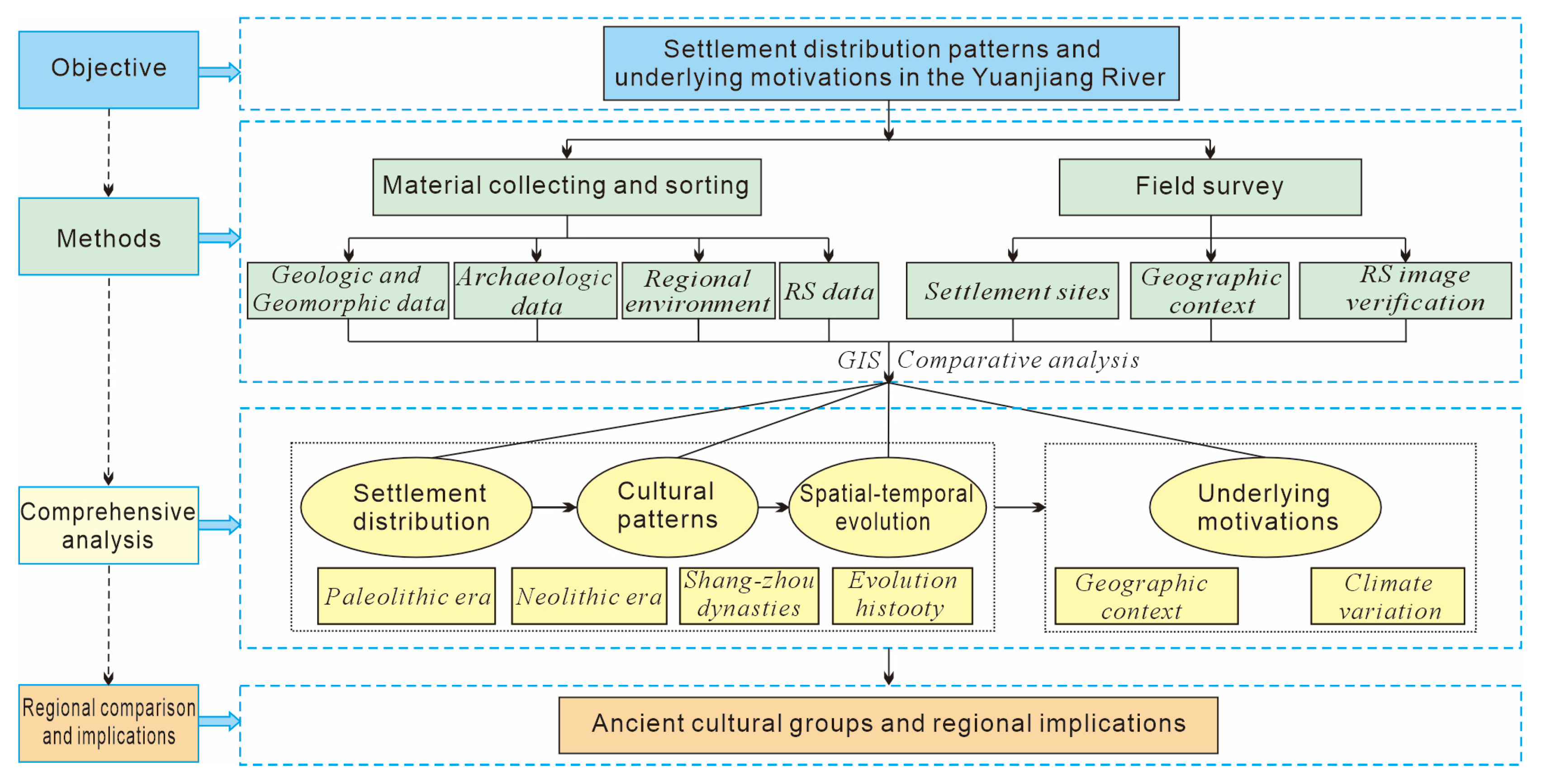
2. Materials and Methods
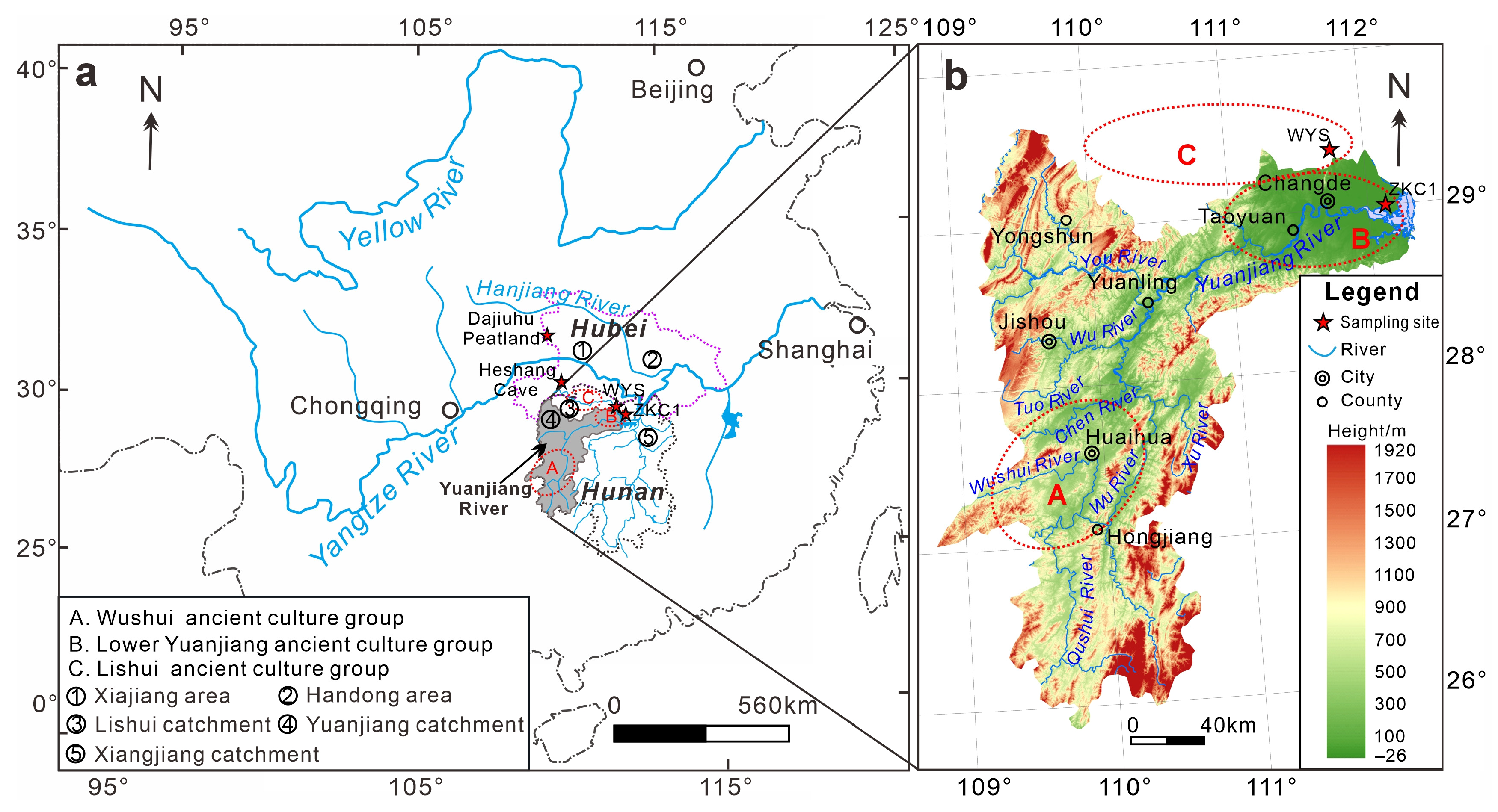
This study utilized a comprehensive approach to examine the relationship between environmental changes and prehistoric settlement patterns. Data were collected and organized to provide an overview of the geological context and features of prehistoric sites. Using field surveys, remote sensing (RS), and Geographic Information System (GIS) data, we validated the distribution patterns of key sites. This methodology enabled us to systematically analyze the spatial and temporal distribution of settlements, identify cultural trends, and explore the key drivers behind these developments. Additionally, this approach facilitated the proposal of human adaptation strategies and the formulation of a long-term sustainability plan for the region (Figure 1).

2.1. Study Area

The Yuanjiang River is a significant tributary of Dongting Lake in the middle Yangtze River basin, flowing eastward into Zhijiang County before entering into the Hunan Province [34,35] (Figure 2a). This river runs predominantly from south to north, traversing the western region of the Hunan Province and passing through several areas, such as Huitong, Huaihua, Shupu, Chenxi, Luxi, Yuanling, and Taoyuan, ultimately emptying into Dongting Lake at Deshan in Changde City. The river stretches 1033 km and drains an area of 89,163 square kilometers, of which 51,066 square kilometers are within the study area. The main river channel extends approximately 568 km between latitudes 26–30° N and longitudes 109–112° E (Figure 2b). The river originates in the Yunnan–Guizhou Plateau, where elevations reach around 2000 m. The middle reaches, extending from Hongjiang to Yuanling, feature hilly banks and intermountain basins. In the lower reaches, the landscape shifts as the hills gradually lower, with a 75-km-long canyon extending from central Yuanling County to Mayihui District. Below Taoyuan, the topography further transforms, with the north bank transitioning into alluvial plains while the south bank retains its hilly terrain (Figure 2b).
The Yuanjiang River Basin is within a subtropical monsoon climate zone, characterized by cold, dry winters with low precipitation and hot, humid summers featuring heavy rainfall. As a typical rain-fed river, the Yuanjiang experiences annual precipitation ranging from 1,090 to 1,506 mm, with rainfall distributed unevenly throughout the year [31]. Approximately 66% of total precipitation occurs from April to August, while the period from December to February contributes only 9%. Average annual temperatures range between 14.3 to 17.2 °C, with warmer temperatures noted in the eastern and southern regions and cooler conditions in the west and north [34].
The river basin is marked by numerous tributaries, particularly as the Yuanjiang enters Hunan Province. The region’s geological landscape features alternating canyons and basins, with the Quaternary system extensively developed in river bends or valley areas. In the downstream regions, plains and hilly terrains dominate, with wide valleys serving as the primary accumulation zones for the Quaternary deposits [31,34]. The region has undergone significant tectonic activity, including major uplift and erosion, influenced by the Indosinian and Yanshanian movements, as well as the east–west structural formations of the Neocathaysian system. Since the Quaternary period, the continental crust has experienced notable uplift and subsidence, resulting in a general topographic pattern of elevated areas in the south and depressions in the north. This tectonic evolution has been characterized by both continuity and intermittency throughout the region [34,35,36].

2.2. Data Source

By compiling and organizing data from archaeological sites located in the middle and lower reaches of the Yuanjiang River, sourced from references, such as The Atlas of Chinese Cultural Relics, Branch of Hunan Province [29], excavation reports, and scholarly research [16,17,18,19,20,21,22,23,24,25,26,27,28,29,30,31,32,37,38,39,40,41,42,43,44], we developed a comprehensive dataset. This dataset, enriched by recent field investigations, encompassed a total of 804 sites spanning from the Paleolithic to the Shang and Zhou dynasties. Specifically, it included 117 Paleolithic sites, 155 Neolithic sites, and 532 suites from the Shang and Zhou periods. Among these, 9 sites contained artifacts from multiple periods, demonstrating cultural continuity across the Paleolithic, Neolithic, and Shang-Zhou eras. The study used 90-m resolution SRTM DEM data for Hunan Province, obtained from the Geospatial Data Cloud website. These data were processed and vectorized using ArcGIS software to generate Digital Elevation Model (DEM) elevation maps of the middle and lower reaches of the Yuanjiang River. Additionally, vector data for water systems and administrative boundaries in China and the Hunan Province were obtained from the Geoinformation Network forum. These datasets were registered and cropped using ArcGIS software to create final vector maps tailored to the water systems and administrative divisions relevant to the study area.

2.3. GIS-Based Analysis Method

This study applied GIS spatial analysis techniques to investigate the spatiotemporal distribution of archaeological sites in the middle and lower reaches of the Yuanjiang River, spanning from the Paleolithic to the Shang and Zhou dynasties. ArcGIS 10.7 software was used to process and vectorize 90-m resolution SRTM DEM data, generating elevation maps for the study area. The DEM data were first cleaned to remove noise and then cropped to align with the study area’s boundaries, ensuring data accuracy. Additionally, vector data for water systems and administrative divisions in China and Hunan Province were obtained from the Geoinformation Network forum. After registration and precise cropping, relevant data for the study area were extracted, forming the basis for further spatial and environmental analysis.
The analysis focused on three key dimensions: temporal distribution, planar spatial distribution, and vertical spatial distribution. Although precise age data were unavailable for many sites, estimates were made based on the terraces on which the sites were located and published chronological data from the region and surrounding areas [35,40,45,46,47]. Paleolithic sites were estimated to date from 300,000 to 10,000 years ago, Neolithic sites were estimated to date from 10,000 to 3600 years ago, and sites from the Shang and Zhou dynasties were estimated to date from 3600 to 2300 years ago. These timeframes allowed for the classification of the sites into three periods: Paleolithic, Neolithic, and Shang-Zhou.
By analyzing artifacts and site characteristics from 804 locations, the cultural evolution of the region was divided into sequential stages. Detailed data from these sites were compiled into a comprehensive dataset and mapped using ArcGIS to generate vector layers for each period. These data were integrated with DEM maps, enabling statistical analysis of various factors, such as elevation and proximity to riverine water sources. This approach provided valuable insights into the spatial distribution of ancient cultural sites and demonstrated how natural environmental factors influenced settlement patterns and cultural development throughout history.

3. Results

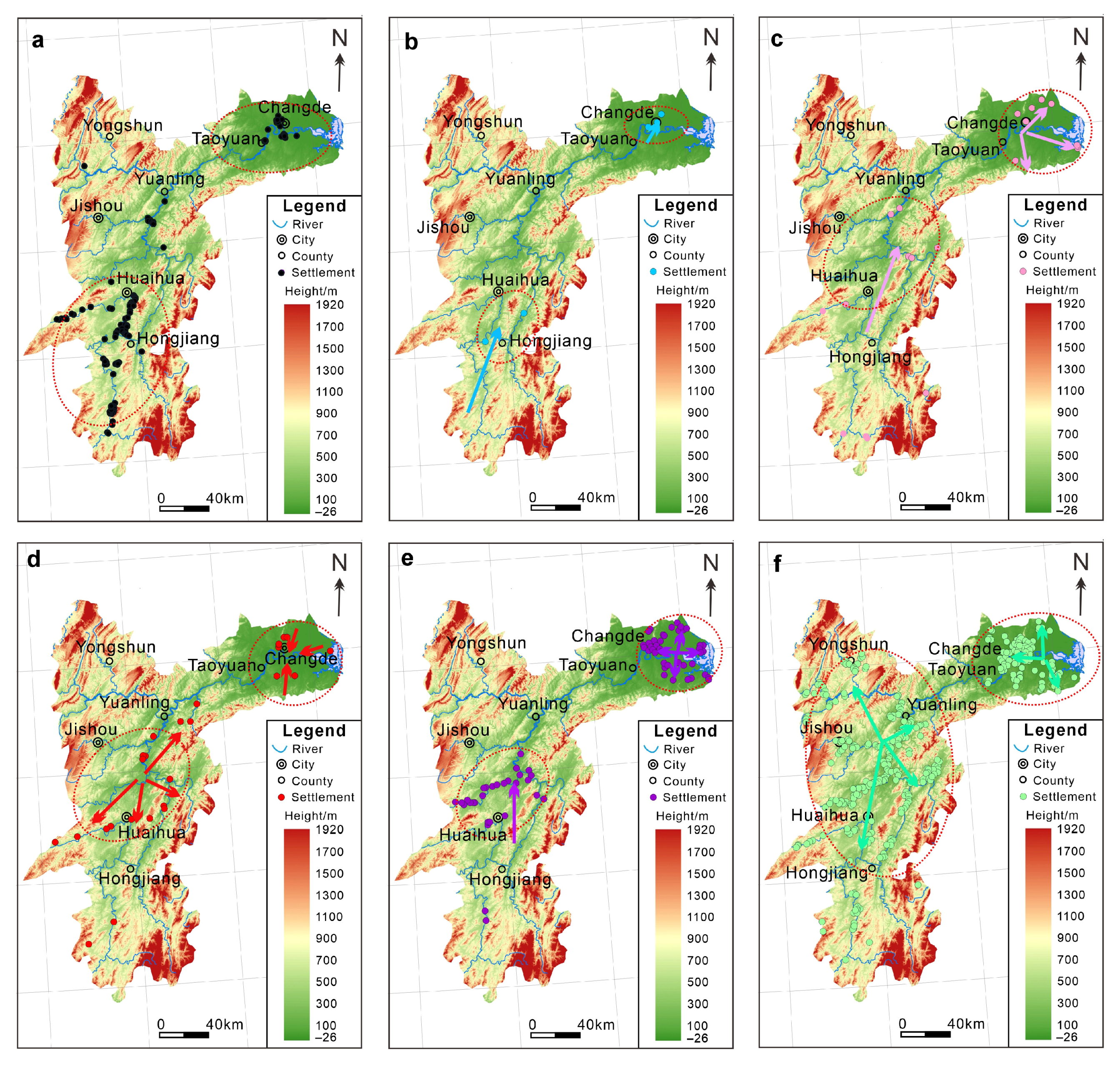
3.1. Patterns of Prehistoric Settlement Distribution Across Different Periods

A total of 804 prehistoric sites have been identified in the middle and lower reaches of the Yuanjiang River (Figure 3). During the Paleolithic era (spanning from 300,000 to 10,000 years ago), 117 sites were mainly concentrated in the flatter middle reaches, at elevations between 100 and 500 m (Figure 3a), while only 17 sites were located in the lower reaches, all below 100 m. Many of these sites were clustered along the Wushui River, forming a distinct cultural group.
During the Neolithic period, archaeological sites in the region expanded significantly, reaching 155, particularly in the lower reaches of the Yuanjiang River, where concentrations of 88 sites emerged in the flat plains. In contrast, the sites of Wushui catchment became more scattered and showed a northward shift, with a notable increase along the Chen River. Other tributaries also experienced a rise in site numbers, reflecting a transition from a centralized distribution to a more even spread in the middle reaches of the Yuanjiang River. Notably, most sites were located at altitudes of 100–300 m, often near riverine water sources, indicating a shift toward a more evenly distributed pattern. During the Lower Zaoshi period, 5 sites were identified near the river (Figure 3b), with numbers rising to 22 in the Daxi period (Figure 3c). The Qujialing period saw 25 mostly small sites (Figure 3d), while the Shijiahe period peaked with 96 sites, leading to the establishment of central urban areas and significant agricultural practices (Figure 3e).
By the Shang and Zhou dynasties, 532 archaeological sites had been established, including new locations in the steep mountain valleys of Yongshun and Baojing counties. This period saw the expansion of the Wushui cultural group and the emergence of larger, more complex communities, especially around Changde City. Sites in the middle reaches were mainly situated in intermountain basins, while those in the lower reaches of the Yuanjiang River resembled Neolithic distributions. However, the number of sites near Doning Lake significantly declined due to the lake’s expansion, affecting local habitation.

3.2. Spatial–Temporal Evolution

From the Paleolithic era to the Shang and Zhou dynasties, the overall number of ancient cultural sites along the Yuanjiang River increased, yet growth trends differed between the middle and lower reaches. In the lower reaches, the total number of sites continued to rise, although the growth rate during the Shang and Zhou dynasties was notably lower than that during the Neolithic period, which saw the establishment of a broad distribution of cultural sites (Figure 3). In contrast, the middle reaches experienced a decline in the number of ancient cultural sites during the Neolithic, diverging from the trend in the lower reaches (Figure 3). However, there was a substantial increase during the Shang and Zhou dynasties, surpassing the growth in the lower reaches. This comparison suggested that the development of ancient cultural sites in these regions evolved independently over time, exhibiting distinct evolutionary characteristics.
Spatially, archaeological sites in the middle and lower reaches of the Yuanjiang River can be divided into two primary areas: the downstream plain, with elevations below 100 m, and the middle intermountain basin, which typically ranges from 100 to 500 m (Figure 3). The central areas of these two regions have undergone shifts over time. From the Paleolithic to the Neolithic period, the center of ancient cultural development in the middle reaches shifted northward. Notably, the number of sites in the downstream areas of the Wushui River and Wushui River systems—where Paleolithic cultures thrived—declined during the Neolithic. Conversely, the Chen River system, extending northward from the Wushui River, experienced a significant increase in sites, forming a new cultural center within a circular area comprising the Chen River, Wushui River, and the mainstream of the Yuanjiang River. From the Neolithic to the Shang and Zhou dynasties, ancient culture in the middle reaches of the Yuanjiang River flourished, with a substantial expansion in the overall distribution. Numerous ancient sites have been identified across various tributaries, resulting in a relatively uniform distribution. Nevertheless, the northward shift in the center of cultural development remains evident (Figure 3). Clusters of sites emerged where the You, Wu, and Chen rivers intersected with the mainstream of the Yuanjiang River, particularly in Chenxi, Luxi, and Yuanling counties, while the significance of the Wushui River system diminished. During the Shang and Zhou dynasties, additional concentrated archaeological sites appeared in Yongshun and Baojing counties, located in the northwest of the middle and lower reaches. This region, characterized by a higher altitude and distance from the main river, formed a relatively independent cultural zone (see Figure 3).
In the lower reaches, ancient cultural sites from the Paleolithic to the Shang and Zhou dynasties were primarily concentrated in the modern urban area of Changde City (Figure 3). Sites from different periods tended to shift either westward or eastward around this urban center. The number of ancient cultural sites in the lower reaches significantly increased from the Paleolithic to Neolithic periods, rising from 17 to 88 sites. This expansion resulted in a rapid increase in cultural distribution, with the center of development still located in Changde City but showing a clear eastward migration toward the Dongting Lake area. Numerous archaeological sites have been discovered around the lake, with some even being submerged. From the Neolithic to the Shang and Zhou dynasties, the number of archaeological sites continued to grow, with a uniform expansion in all directions (Figure 3f). However, during this time, the center of ancient cultural development shifted southwest of Changde City, leading to a decrease in sites to the east. In the Dongting Lake area, only a few archaeological sites were found, and none were located within the lake itself.

4. Discussion

4.1. Geographic Context Controlling the Spatial–Temporal Distribution

The study area presents a diverse landscape of canyons and prominent river valley basins, including the Shupu, Zhijiang, Yuanma, Anhong, and Qushui basins [27,34,35,48]. This is primarily the result of the Neocathaysian tectonic system’s influence, which plays a key role in shaping its unique geomorphic environment [45]. Bordered by majestic mountains to the north, west, and south, the area contrasts sharply with the expansive Dongting Lake Plain to the east (Figure 1). The stunning Wuling Mountains and the Yunnan–Guizhou Plateau, both known for their snow-capped peaks, further enhance the landscape. A significant geographical feature is the intersection of the Xuefeng and Wuling mountain ranges, forming a distinctive Chinese “eight” shape around Yuanling County. This configuration has facilitated the development of two prominent ancient cultural groups: the “Wushui Ancient Cultural Group” from the middle Yuanjiang catchment and the “Lower Yuanjiang Ancient Cultural Group”, as depicted in Figure 1.
Our literature analysis indicated that the first to fourth-level terraces were widely distributed along the lower reaches of the Yuanjiang River, while the fifth and sixth terraces were less common [34,35,40]. Taoyuan County was notable for its well-developed terraces, serving as a key reference point for analyzing surface height ratios, which were measured at 8–14, 14–21, 34–46, 71–82, 80–110, and 120–140 m above river level (a.r.l.) based on our field survey, consistent with previous studies [25,34,35,47,49] (Table 1).
The terrace deposits exhibited a binary phase structure, reflecting the complex geological and hydrological processes that have shaped the region over time. Sites on the fourth level and some third-level terraces might date back to the late early-Paleolithic period or early mid-Paleolithic period, while those on the second level and certain third-level terraces correspond to the middle or late mid-Paleolithic period. The first and some second-level terraces are associated with the late Paleolithic period. Distinct vertical migration patterns in Paleolithic culture were attributed to tectonic movements. Previous studies suggested that high river marshes and low terraces near rivers were most conducive to human survival, offering low-lying terrain, abundant water sources, lush vegetation, and ample stone resources [19,25,27,40]. Consequently, Paleolithic humans typically inhabited high floodplains and low terraces near rivers. Based on these findings and the analysis in Figure 3 and Table 1, it could be inferred that the lower terraces from the Paleolithic era would rise to higher elevations due to subsequent tectonic uplift.
Additionally, the middle and lower reaches of the Yuanjiang River have undergone at least five or six cycles of erosion base level decline or tectonic uplift movements (as indicated by Table 1). The last four tectonic uplifts likely had the most significant impact on the development of prehistoric settlements. This geomorphological landscape not only influenced the natural environment but also played a crucial role in the region’s historical and cultural evolution. The diverse topography likely affected settlement patterns, agricultural practices, and the distribution of ancient cultural sites, enriching the complex narrative of human history in the middle and lower reaches of the Yuanjiang River.

4.1.1. Topographic Feature in Relation to Prehistoric Settlements

The elevation of the middle and lower reaches of the Yuanjiang River is closely linked to the region’s terrain and landforms. The middle reaches are characterized by intermountain basin landforms with altitudes between 100 and 500 m, while the lower reaches primarily feature flat plain landforms below 100 m. Both types of terrain consist of low, flat, and open areas, which have played a significant role in human settlement and cultural development. Statistical analyses using ArcGIS software highlighted distinct patterns in the distribution of archaeological sites across various elevations (see Figure 4a). The distribution of Paleolithic sites was concentrated in relatively flat and open regions around 100–500 m above sea level. In contrast, there were fewer sites located below 100 m [29]. During the Neolithic period, archaeological sites became more widely distributed, with many found below 500 m. This broader distribution reflected the rapid cultural development occurring in the lower reaches of the Yuanjiang River, resulting in a significant number of sites below 100 m. By the Shang and Zhou dynasties, patterns of human habitation evolved, as the number of archaeological sites above 500 m began to increase (Figure 4a). This shift indicated that communities were moving beyond low-lying areas near riverine water sources, motivated largely by the need to avoid floods and other environmental hazards. As agricultural practices expanded, there was a growing reliance on stable living conditions, allowing populations to settle at higher altitudes to mitigate flooding risks [19,25,32].
In summary, the impact of altitude on ancient cultural changes was particularly evident in the middle reaches of the Yuanjiang River, especially between 100 and 500 m. The site distribution from the Paleolithic period suggests a preference for higher altitudes, driven by the challenges that early humans faced in adapting to their environment and the necessity of finding safer, flood-resistant locations. From the Neolithic to the Shang and Zhou dynasties, the altitude distribution of ancient cultural sites remained relatively stable, with a predominant concentration below 300 m. This stability implied that human habitation patterns in the middle reaches have been fairly consistent since the Neolithic, offering valuable insights into site selection for ancient communities [19,25]. Although the research area spans nearly 100,000 square kilometers, there is an error of approximately 100 m in the location data on the cultural relic map. However, the integration of 90-m resolution SRTM data is sufficient to capture the macroscopic geomorphic features of the site. Furthermore, the terrain pattern within the study area is not expected to undergo significant changes across such a vast area, allowing for the identification of correlations between topographic features and prehistoric settlements.
Regionally, an altitude of 100 m serves as a boundary between the middle and lower reaches of the Yuanjiang River. Archaeological sites below this elevation were located in the lower reaches, while those above were found in the middle reaches. Over time, the number of archaeological sites in the lower reaches increased steadily from the Paleolithic through the Shang and Zhou dynasties, maintaining a consistent growth rate. In contrast, the middle reaches experienced a significant decline in site number during the Neolithic, followed by a rapid resurgence in the Shang and Zhou periods. These cultural developments reflected the profound influence of geological environments on ancient societies. During the warmer Neolithic period, human activities thrived in the low-altitude plains, which provided more favorable conditions for growth compared to the more enclosed mountain basins. By the Shang and Zhou dynasties, the middle reaches underwent accelerated development, primarily fueled by agricultural advancements. The fertile river basins became crucial for agricultural production, underscoring the role of altitude in shaping cultural transitions and settlement patterns. As agriculture emerged as the dominant mode of production, areas suitable for cultivation became key sites for cultural change and development [19,25,27,31,40].

4.1.2. Distance Away from the River

Statistical data analysis clearly showed a continuous increase in the distance to riverine water sources in site distributions since the Paleolithic era. Most archaeological sites from the Paleolithic and Neolithic periods were located between 500 and 1000 m from water. However, by the Shang and Zhou dynasties, settlements typically ranged from 1000 to 3000 m away, reflecting a notable shift in settlement patterns (Figure 4b). The concentration of Paleolithic sites within 3000 m of water highlighted the critical dependence of ancient humans on nearby water for survival. This reliance underscored their limited production capabilities and vulnerability to natural disasters, like flooding and waterlogging, making access to water essential for drinking, fishing, and other subsistence activities.
During the Neolithic period, while the overall proximity to water remained relatively stable, there was a notable increase in the number of sites located within 500 m of water. This change suggested that Neolithic communities developed strategies to mitigate flood risks, aided by advancements in tools and the emergence of social tribes [19,25,27]. With more secure and diverse livelihoods, such as agriculture and animal husbandry, Neolithic humans enjoyed greater flexibility in choosing settlement locations. They balanced the need for water accessibility with protection from natural hazards, leading to more strategic site selection. Notably, seven sites were identified over 5000 m from water in the water-surrounded area of Nanpinggang Town, Changde City, during this period. These clustered settlements, though distanced from direct water access, were located on elevated terrain that protected against flooding [31]. This adaptive response to environmental challenges allowed communities to prioritize safety while still accessing essential resources.
By the Shang and Zhou dynasties, most archaeological sites were found 1000 to 3000 m from river water. In contrast to the Neolithic period, the overall distance of archaeological sites from water increased, with a significant rise in the number of sites situated over 5000 m away (Figure 4b). This shift suggested that, during this time, humans had developed greater self-sufficiency, reducing their reliance on proximity to water. Innovations, such as irrigation systems, facilitated more intensive agricultural development, resulting in a transition from a survival-based lifestyle to one that was more sustainable and productive. As a result, humans’ capability to manage environmental risks improved significantly.
Overall, the trend in archaeological site locations from the Paleolithic onward demonstrated that most sites were situated within a range of 500 to 3000 m from water. This pattern indicated that this distance range was optimal for human development, balancing resource accessibility with the need to mitigate environmental risks [19,25]. These insights hold valuable implications for modern settlement planning, emphasizing the importance of considering both resource access and environmental safety in community establishment.

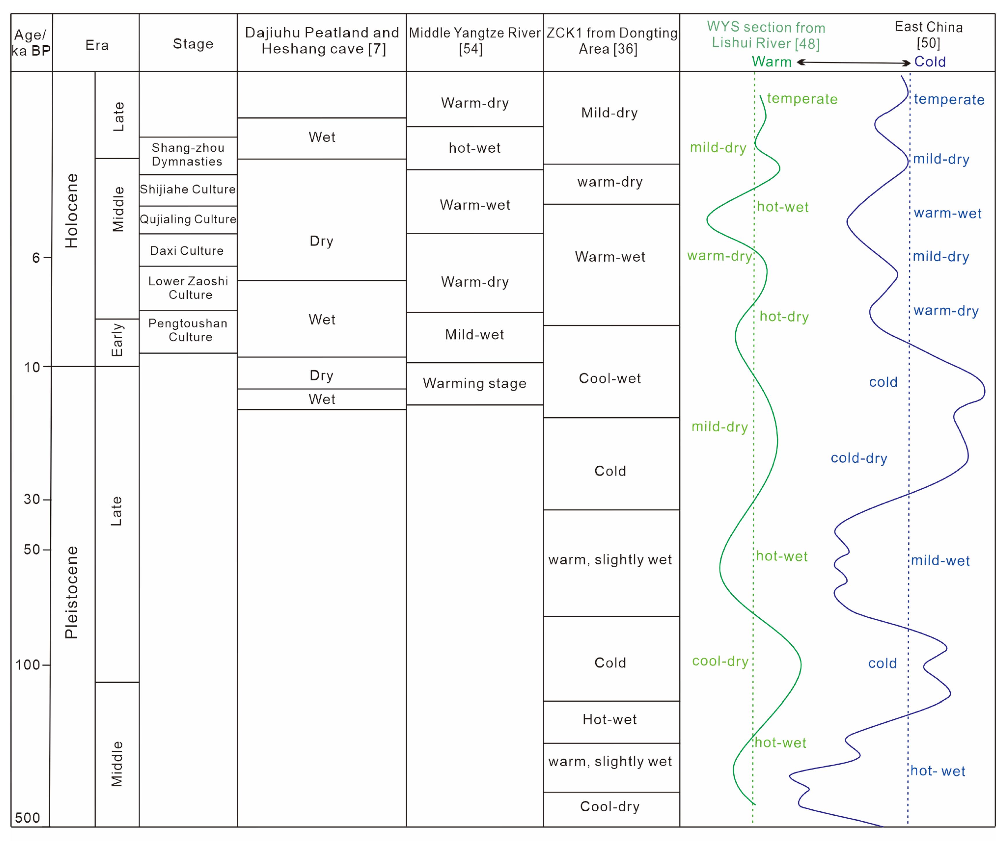
4.2. Climate Variations in Linkage to Prehistoric Occupation

Research on the Paleolithic climate in the middle reaches of the Yuanjiang River was somewhat limited, primarily relying on insights derived from glacial deposits. However, the lower reaches, particularly the Dongting Lake Plain, have yielded more extensive climate studies [30,36,48,49,50,51,52,53,54]. Analysis of Paleolithic sites in both the middle and lower reaches of the Yuanjiang River revealed that their distribution across the first, second, and third level terraces, with 39, 63, and 15 sites, respectively. Despite potential discrepancies between the archaeological data and regional climate records, a clear relationship between site numbers and climate conditions emerged (Figure 5).
During the early Middle Pleistocene, a cold and dry climate created unfavorable conditions for human development. However, as temperatures warmed during the middle Pleistocene, human activity in the region increased and continued into the late Pleistocene. This warming trend supported greater human occupation, as evidenced by the rising number of archaeological sites (Figure 3 and Figure 5). A subsequent cooling phase in the late Pleistocene, however, hindered further expansion, leading to a decline in site numbers.
During the Lower Zaoshi culture period (7800–6300 BP), which coincided with the river or lake-cutting phase and the expansion of Dongting Lake, the number of archaeological sites remained relatively low. This suggests a weak correlation between environmental changes and human activity. In contrast, the Daxi culture period (6300–5300 BP) aligned with a “warm and slightly dry” Holocene optimum climate and the peak expansion of Dongting Lake (Figure 5). To avoid flooding, human populations likely sought higher ground, although some sites within the lake area indicate an adaptation to living near or on the water, showcasing an important development in environmental manipulation. In the Qujialing culture period (5300–4600 BP), the warm Holocene climate persisted, but trends toward hotter and wetter conditions emerged. The number and distribution of archaeological sites remained similar to those of the Daxi period. The transition from the Qujialing to the Shijiahe culture marked a period of rapid cultural development differing from earlier patterns. This shift suggests that sudden external factors, such as the climate change event around 4.2 ka BP, played a crucial role in human development, as highlighted in previous studies [55,56,57]. This event, part of the larger mid-to-late Holocene climate shift, proved to be a significant turning point for human civilizations. In some regions, ancient cultures declined, while in others, such as the middle reaches of the Yuanjiang River, agricultural development accelerated after a period of adaptation, leading to rapid human expansion. These findings align with the results of the current study. During the subsequent Shijiahe culture period (4600–3600 BP), ancient cultures flourished, particularly in the lower reaches of the Yuanjiang River, where human settlements expanded significantly. Environmental constraints that had previously influenced settlement patterns diminished, allowing communities to inhabit areas beyond high river floodplains or terraces. Evidence of small dwellings suggested the emergence of private spaces, marking a shift away from communal living.
In the Shang and Zhou dynasties (1600–256 BC), cultural sites, particularly those associated with the Wushui cultural group, became more widespread, forming large communities along the river basins. While the distribution of sites in the lower reaches overlapped with those of the Neolithic period, the number of lakeside settlements decreased significantly. This decline was attributed to the expansion of Dongting Lake and frequent flooding during the Shang and Zhou periods, consistent with prior research on rising lake levels during this time [19,25,31,58] (Figure 3).

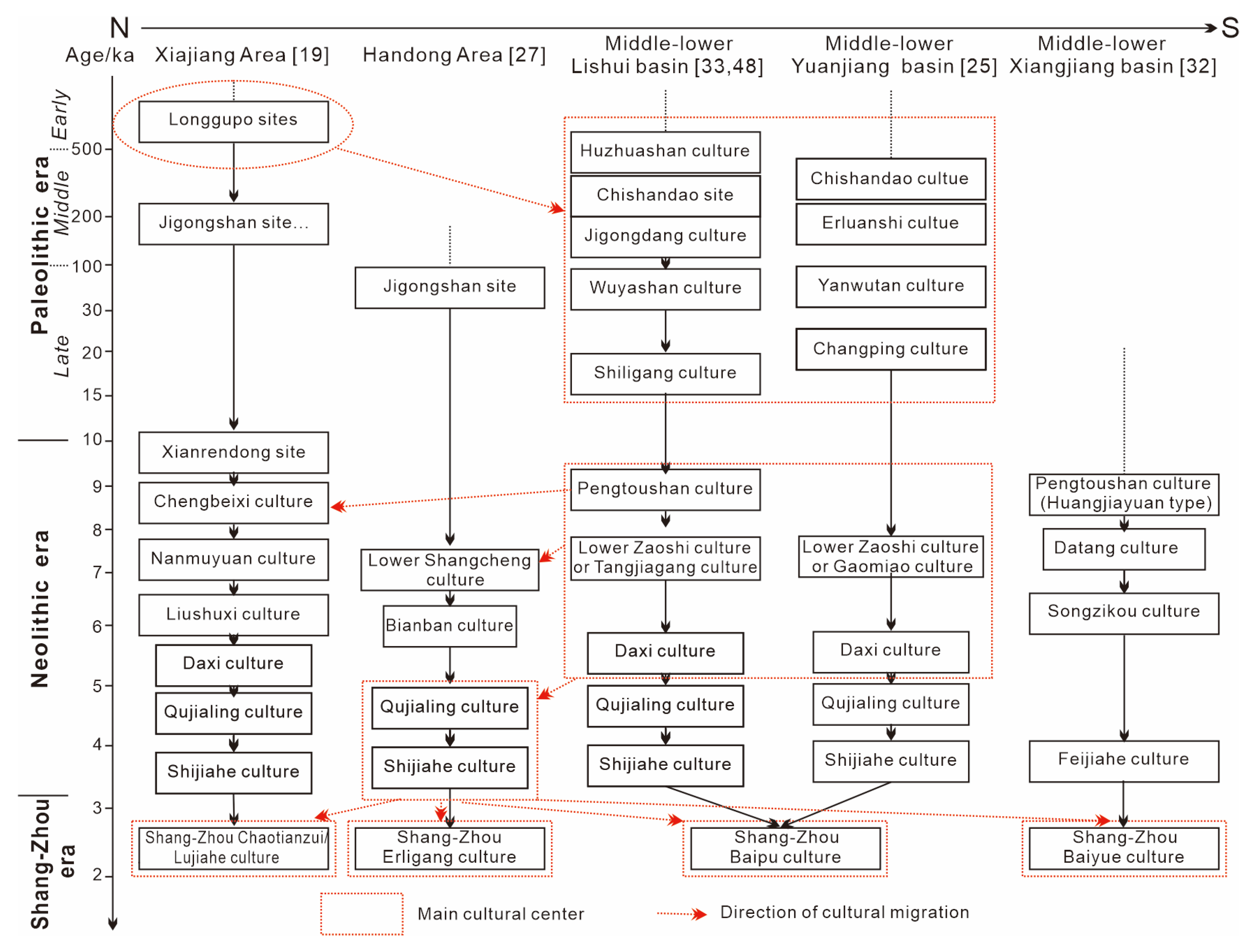
4.3. Attribution of Ancient Cultural Groups

A comparative analysis was conducted between the lower reaches of the Yuanjiang River and both the middle reaches of the Yuanjiang and the Lishui River Basins to explore the influence of different geographical environments on ancient cultures. The study revealed several similarities between the Wushui ancient cultural group and the lower Yuanjiang River ancient culture region, particularly in their use of riverbed gravel for making stone tools [19,25]. Both cultures primarily produced single-sided blades approximately 15 cm long and emphasized large chopping and smashing tools. However, significant differences also existed. The Wushui group predominately utilized banded metamorphic sandstone, while the lower Yuanjiang River region is characterized by a variety of siliceous rocks, with fewer occurrences of metamorphic sandstone. The sharp edge smashing technique seen in the Wushui ancient cultural group, akin to methods from Guizhou’s Maomao Cave, was absent in the lower Yuanjiang River, where stone fragments were generally thicker and featured flat gravel tabletops with concentrated impact points. In terms of chip production, the lower Yuanjiang River employed both single-sided and double-sided strikes, processing both the fracture and back surface of stones. In contrast, the Wushui cultural group exclusively used single-sided slicing without any secondary processing. The Wushui cultural group displayed a more uniform range of vessel types, lacking the slender triangular pointed vessels presented in the Wushui cultural group. Both cultures utilized chopping tools, but the Wushui cultural group typically struck one side of a long piece of flat gravel, while tools from the lower Yuanjiang River might have involved single-sided, double-sided, or bi-directional strikes.
The paleolithic rocks in the lower reaches of the Yuanjiang River also shared significant similarities to those of the Lishui cultural group [19,25,40]. Both regions employed riverbed gravel for stone tools, including quartz, flint, quartzite, siliceous rock, and sandstone, though the proportions of these materials varied. Hammering techniques for chip production and tool repair were common in both areas, with single-sided chip cutting being prevalent, alongside some instances of double-sided techniques. Tool processing generally involved striking both the fracture surface and the back, yielding thick stone fragments with flat gravel surfaces and concentrated impact points, notably different from the sharp-edged fragments of the Wushui cultural group. Both regions predominantly featured large stone tools, with small tools being rare. However, a trend towards miniaturization emerged in the Lishui River Basin during the late Paleolithic era. Similar combinations of stone tools existed in both areas, including pointed tools, scrapers, stone balls, and chopping tools, with triangular pointed objects being common. The pointed tools in the lower Yuanjiang River were slender and elongated, differing from the short dorsal pointed vessels found in the Wushui cultural group. The production processes and shapes of triangular pointed vessels and stone balls were consistent between the two regions [19,25,40]. Despite these similarities, the stone tools in the lower Yuanjiang River appear to be more monotonous. Although there were some similarities in production techniques and shapes of pointed vessels, the Lishui cultural group exhibited greater diversity. The lower Yuanjiang River contained fewer large chopping tools, likely due to its shorter archaeological development compared to the Lishui River Basin [25,31]. While both regions predominantly featured large stone tools, those in the lower Yuanjiang River tended to be smaller and less robust than those in the Lishui cultural group, resembling tools from the Wushui cultural group. Additionally, while both regions share similar lithological characteristics, the metamorphic siltstone commonly used in the Wushui cultural group was less prevalent in the lower Yuanjiang River.
Overall, these differences suggested that while the Paleolithic cultures of the lower Yuanjiang River and the Wushui cultural group were related, they represented distinct archaeological cultures. In contrast, the lower Yuanjiang River and Lishui cultural groups shared numerous commonalities, indicating that the former might exhibit transitional characteristics between the two [19,25,31,33,40]. Its specific geographic context, characterized by broad floodplains, made this area favorable for agriculture and settlement. The middle Yuanjiang River, which originates in southeastern Guizhou Province and flows through Hunan into West Dongting Lake, is bordered by the Yunnan–Guizhou Plateau to the west and the high Xuefeng and Wuling Mountains to the east and north, creating a relatively isolated geographical area associated with the Wushui cultural group. The cultural practices here would have the potential for more transient or mixed economies due to the geographical constraints. The Lishui River, flowing from Sangzhi County in northwestern Hunan into West Dongting Lake, is bordered by the Wuling Mountains to the south and separated from the Qingjiang River to the north. This would be conducive to a rich cultural tapestry reflecting both agricultural and fishing communities. Paleolithic artifacts were primarily found in the middle and lower reaches of the Yuanjiang River [27,32]. Despite being part of different water systems, the Lishui River and the lower Yuanjiang River form a cohesive geographical area, reflecting the interconnectedness of their respective Paleolithic cultures [31,32].

4.4. Regional Implications of Ancient Culture Lineages in the Middle Yangtze Catchmen

This study provided an in-depth analysis of the archaeological culture in the middle and lower Yuanjiang River Basin, highlighting its unique characteristics compared to neighboring regions of the middle Yangtze River (Figure 6). By meticulously examining various archaeological sites, artifact assemblages, and cultural practices, the research aimed to shed light on the distinct developments in this basin, shaped by both its geographical features and historical contexts (Table 2).
During the Paleolithic era, cultural development was primarily concentrated in the southern regions, especially within the middle and lower reaches of the Lishui and Yuanjiang River Basins, while the northern region centered around Jianghan [55,58,59,60] (Figure 6; Table 2). Early to mid-Paleolithic sites in Xiajiang Area, found along the river terraces of the Hanjiang River Basin, revealed a variety of stone tools, including chopping and pointed implements. In contrast, the late Paleolithic period showcased smaller tools, like scrapers. The tool assemblages from the Yuanjiang River Basin predominantly included chopping and smashing tools, with fewer miniaturized implements emerging later. Despite their geographical proximity, the cultures of the Lishui and Yuanjiang Basins exhibited significant differences and connections, influenced by their unique terrains and external cultural interactions [25,32] (Figure 6). The low hills of the Lishui River Basin facilitated exchanges with Jianghan, while the mountainous environment of the Yuanjiang River Basin fostered a more isolated cultural development.
Figure 6. Regional genealogy of prehistoric cultures in the middle Yangtze catchment (referring to [19,25,27,32,33,48]).
Applsci 15 02064 g006
Table 2. Comparative analysis of Paleolithic cultures in the study area and the middle Yangtze River basin (Modified from [33,48,61,62]).
AreaEarly PaleolithicMiddle PaleolithicLate Paleolithic
Jianghan Plain [61]Large tools including chopping implements, pointed tools, stone balls, and scrapers in the third–fourth-level terraces in Hanshui catchmentLarge tools, such as chopping tools, pointed tools, and stone balls in the second- or third-level terraces in Hanshui catchmentLightweight scrapers and small stone flakes (indicative of miniaturization) in Jianghan Plain
Along the Yangtze River [27]---Large chopping and scraping tools in caves along the river---
Lishui River [33]Large chopping tools, pointed tools, and scrapers in the third- or fourth-level terraces in middle-lower Lishui RiverLarge chopping tools, triangular pointed tools, stone balls, and others in the second- or third-level terraces in the middle-lower Lishui RiverSharp-shaped scrapers, standard scrapers, and small stone flakes indicative of iniaturization in the second- or first-level terraces in the middle-lower Lishui River
Yuanjiang River [41,62]Large-sized chopping and scraping tools in the third- and second-level terraces in the middle Yuanjiang RiverLarge long-bodied side-blade choppers and double-sided blade choppers found in the second-level terraces of the middle Yuanjiang RiverLarge short-bodied sharp-edged choppers in the first or second-level terraces
In the Neolithic era, the cultural landscape of the middle Yangtze region became more self-contained, leading to the development of various local cultures. The Pengtoushan culture in the Liyang Plain evolved into several local cultures, including Chengbeixi, Nanmuyuan, and Liulinxi. Other important cultures, such as the Datang and Duiziling cultures along the Xiangjiang River together with the Gaomiao and Songxikou cultures in the Yuanjiang River, enriched this cultural mosaic. The Dongting Lake area emerged as a cultural center, fostering early agriculture and walled settlements, although its limited external communication resulted in cultural isolation (Figure 6). During the Qujialing culture period, cultural exchanges intensified with the integration of the Daxi culture, but the influence of the Liyang Plain diminished, shifting toward the Handong region [25,32,40]. Hunan’s cultural landscape became increasingly marginalized, particularly with the southward transmission of Erlitou culture. Despite the discovery of Erlitou pottery in Hunan, the region remained peripheral, notably lacking any bronze artifacts from this period.
In contrast, during the Shang and Zhou dynasties, significant bronze artifacts comparable to the early Yinxu culture were discovered in Hunan. Notable finds at Tonggu Mountain in Yueyang and the Huangcai site along the Tanhe River in Ningxiang included diverse bronze items, such as the Four Sheep Square Zun and the Man Faced Cauldron, alongside numerous local-style artifacts [27,33,48]. The origins of these bronze items were debated, raising questions about their production, i.e., whether they were crafted locally, imported from the Central Plains, or crafted by local artisans using techniques acquired from that region. The social structure of Hunan during this period remains ambiguous, with uncertainties regarding whether it was organized as a state or local group. This period may have marked a cultural shift southward, with the study area serving as a vital cultural conduit between the Yangtze River and the Pearl River basins. Despite these complexities, Hunan emerged as a distinct local entity, forging intricate connections to the south and playing a significant role in the early unity and diversity of Chinese civilization [19,25,31,32,33,41,48,61,62,63].

5. Conclusive Remarks

This article examined prehistoric settlement patterns and cultural transformations in the middle and lower reaches of the Yuanjiang River, utilizing geological, geomorphological, archaeological, and RS data as well as GIS techniques to trace the developments from the Paleolithic to the Shang-Zhou dynasties. This study revealed significant shifts in site distribution over time: Paleolithic and Neolithic sites were typically situated at higher altitudes and farther from riverine water sources, while those from the Shang-Zhou period were found in lower, more flood-prone areas, reflecting different adaptive strategies to environmental conditions. Geological context was a critical factor in shaping these cultural shifts, with northward migrations in the middle reaches and eastward or eastward movements in the lower reaches, particularly influenced by the evolution of Dongting Lake near Changde City. An analysis of 804 sites revealed a clear trend: as one moves eastward, altitude decreases and proximity to water increases, predominantly in low-lying areas. The region’s distinctive geomorphology, defined by mountainous borders and the Dongting Lake Plain, features significant landmarks, such as the Wuling Mountains and the Yunnan–Guizhou Plateau. Key cultural groups, like the Wushui and Lishui cultures, developed within these varied landscapes. Cultural changes in the lower reaches were closely tied to climatic variations and natural disasters, particularly during the Shijiahe and Shang-Zhou periods. In contrast, the middle reaches were less affected by environmental factors due to their more enclosed landscapes. This study emphasized the complex relationship between environmental factors and cultural evolution in the Yuanjiang River region, revealing distinct trajectories shaped by geology, climate, and human adaptability. Additionally, a regional comparative analysis suggested that the middle reaches of the Yangtze River might have originated in the Xiajiang Area, gradually shifting southward with the development of the Lishui River Basin, leading to several cultural centers that underscored the unique significance of the Yuanjiang region in Hunan Province. Ongoing research in this area promises to further enhance our understanding of human history and ancient cultures, offering valuable insights for modern sustainable practices and highlighting the relevance of past lessons to contemporary challenges.

Author Contributions

Conceptualization, G.Y.; methodology, G.Y.; formal analysis, C.Y.; investigation, G.Y.; writing—review and editing, G.Y. and C.Y.; funding acquisition, G.Y. All authors have read and agreed to the published version of the manuscript.

Funding

This research was funded by the National Natural Science Foundation of China (Grant number 41172167) and the Fundamental Research Funds for the Central Universities (Grant numbers 2652017216 and 2652017285).

Data Availability Statement

The original contributions presented in the study are included in the article; further inquiries can be directed at the corresponding authors.

Acknowledgments

We extend our sincere gratitude to Y.Q. Meng for his participation in the field survey.

Conflicts of Interest

The authors declare no conflicts of interest.

References

  1. Timmermann, A.; Friedrich, T. Late Pleistocene climate drivers of early human migration. Nature 2016, 538, 92–95. [Google Scholar] [CrossRef] [PubMed]
  2. Tan, B.; Wang, H.W.; Wang, X.Q.; Zhou, J.; Ma, C.; Dai, X.Y. The study of early human settlement preference and settlement prediction in Xinjiang, China. Sci. Rep. 2022, 12, 5072. [Google Scholar] [CrossRef] [PubMed]
  3. Curdy, P. Prehistoric settlement in middle and high altitudes in the Upper Rhone Valley (Valais-Vaud, Switzerland): A summary of twenty years of research. Preist. Alp. 2007, 42, 99–108. [Google Scholar]
  4. Da, H.B. The Research on the Relations Between Culture and Ecological Environment of Neolithic Age in the Middle Reaches of Yangtze River. Ph.D. Thesis, Central China Normal University, Wuhan, China, 2009. (In Chinese with English abstract). [Google Scholar]
  5. Li, J.C.; Han, L.Y.; Zhang, G.M.; Su, Z.Z.; Zhao, Y.F. Temporal-spatial variations of human settlements in relation to environment change during the Longshan culture and Xia-Shang periods in Shanxi Province, China. Quat. Int. 2017, 436, 129–137. [Google Scholar] [CrossRef]
  6. Lü, J.Q.; Mo, D.W.; Zhang, Y.J.; Jiang, J.Q.; Liao, Y.N.; Lu, P.; Ren, X.L. Holocene geomorphic evolution and settlement distribution patterns in the mid-lower Fen River basins, China. Quat. Int. 2019, 521, 16–24. [Google Scholar] [CrossRef]
  7. Xie, S.; Evershed, R.P.; Huang, X.; Zhu, Z.; Pancost, R.D.; Meyers, P.A.; Gong, L.; Hu, C.; Huang, J.; Zhang, S.; et al. Concordant monsoon-driven postglacial hydrological changes in peat and stalagmite records and their impacts on prehistoric cultures in central China. Geology 2013, 41, 827–830. [Google Scholar] [CrossRef]
  8. Zhang, X.L.; Ha, B.B.; Wang, S.J.; Chen, Z.J.; Ge, J.Y.; Long, H.; He, W.; Da, W.; Nian, X.M.; Yi, M.J.; et al. The earliest human occupation of the high-altitude Tibetan Plateau was 40 thousand to 30 thousand years ago. Science 2018, 362, 1049–1051. [Google Scholar] [CrossRef]
  9. Mandel, R.D.; Simmons, A.H. Prehistoric occupation of late Quaternary landscapes near Kharga Oasis, Western Desert of Egypt. Geoarchaeology 2001, 16, 95–117. [Google Scholar] [CrossRef]
  10. Magny, M. Holocene climate variability as reflected by mid-European lake-level fluctuations and its probable impact on prehistoric human settlements. Quat. Int. 2004, 113, 65–79. [Google Scholar] [CrossRef]
  11. Nicoll, K. Recent environmental changes and prehistoric human activity in Egypt and Northern Sudan. Quat. Sci. Rev. 2004, 23, 561–580. [Google Scholar] [CrossRef]
  12. Yasuda, Y.; Fujiki, T.; Nasu, H.; Kato, M.; Morita, Y.; Mori, Y.; Kanehara, M.; Toyama, S.; Yano, A.; Okuno, M.; et al. Environmental archaeology at the Chengtoushan site, Hunan Province, China, and implications for environmental change and the rise and fall of the Yangtze River civilization. Quat. Int. 2004, 123–125, 149–158. [Google Scholar] [CrossRef]
  13. Chen, Z.Y.; Zong, Y.Q.; Wang, Z.H.; Wang, H.; Chen, J. Migration patterns of Neolithic settlements on the abandoned Yellow and Yangtze River deltas of China. Quat. Res. 2008, 70, 301–314. [Google Scholar] [CrossRef]
  14. Liu, T.; Chen, Z.Y.; Sun, Q.L.; Finlayson, B. Migration of Neolithic settlements in the Dongting Lake area of the middle Yangtze River basin, China: Lake-level and monsoon climate responses. Holocene 2011, 22, 649–657. [Google Scholar] [CrossRef]
  15. Wu, L.; Li, F.; Zhu, C.; Li, L.; Li, B. Holocene environmental change and archaeology, Yangtze River valley, China: Review and prospects. Geosci. Front. 2012, 3, 875–892. [Google Scholar] [CrossRef]
  16. Shan, X.J. Investigation of ancient cultural sites in the middle and lower reaches of the Yuanjiang River in Hunan. Archaeology 1980, 1–6. (In Chinese) [Google Scholar]
  17. Xi, D.H. Survey report on Paleolithic materials in the lower reaches of the Yuanjiang River. Hunan Archaeol. J. 1994, 8–13. (In Chinese) [Google Scholar]
  18. Xi, D.H.; Xu, X.L.; Ma, Y.H. Second survey report on Paleolithic tools in the lower reaches of the Yuanshui River. Archaeology 1997, 41–50. (In Chinese) [Google Scholar]
  19. He, J.J. A century review of Hunan archaeology. Archaeology 2001, 4, 3–12, (In Chinese with English abstract). [Google Scholar]
  20. He, J.J. The Neolithic culture in the Dongting Lake area. J. Archaeol. 1986, 385–408, (In Chinese with English abstract). [Google Scholar]
  21. Lin, S.J.; Liu, C.Z. Overview of the Paleolithic culture in Shangbao, Huxi County, Western Hunan. J. Jishou Univ. Soc.Sci. 1990, 12, 110–113. (In Chinese) [Google Scholar]
  22. Xi, D.H.; Lei, F. Prehistoric archaeological review in northwest Hunan in the past ten years. Jianghan Archaeol. 1993, 30–34. (In Chinese) [Google Scholar]
  23. Cao, C.S. A brief discussion on the stone age culture on the north shore of Dongting Lake. Southeast Cult. 1994, 6, 59–71. (In Chinese) [Google Scholar]
  24. Xiang, K.W. Exploration of Beiqiu Site in the middle reaches of the Yuanjiang River. J. Huaihua Teach. Coll. 1998, 17, 39–41. (In Chinese) [Google Scholar]
  25. Xi, D.H. Discussion on Paleolithic remnants along lower reaches of Yuan River. Jianghan Archaeol. 2002, 41–49, (In Chinese with English abstract). [Google Scholar]
  26. Wu, C.C.; Lv, J.M.; Qi, S.M.; Yu, J.S.; Yu, P.R. Human sites and ecological survey in northwest area of Hunan Province. J. Jishou Univ. Nat. Sci. Ed. 2007, 28, 117–120, (In Chinese with English abstract). [Google Scholar]
  27. Guo, W.M. Culture and Society on Liyang Plain and Handong Area During the Neolithic Period; Central Relics Press: Beijing, China, 2010; pp. 1–336. (In Chinese) [Google Scholar]
  28. Yang, L.S. From Huzhao Mountairo Tangjiagang: A study on ‘Huxiang Characteristics’ in the Process of Prehistoric Culture. Ph.D. Thesis, Central China Normal University, Wuhan, China, 2022. (In Chinese with English abstract). [Google Scholar]
  29. Bureau of Chinese Cultural Relics. The Atlas of Chinese Cultural Relics, Branch of Hunan Province; Cartographic Press of Hunan: Changsha, China, 1997; pp. 1–542. (In Chinese) [Google Scholar]
  30. Du, Y. Neolithic sites and historical environment in the Dongting Lake area. J. Cent. Norm. Univ. Nat. Sci. 2002, 36, 516–520, (In Chinese with English abstract). [Google Scholar]
  31. Meng, Y.Q. Distribution and Migration of Paleoculture Sites in the Middle and Lower Reaches of the Yuanjiang River. Master’s Thesis, China University of Geoscience, Beijing, China, 2019. (In Chinese with English abstract). [Google Scholar]
  32. Guo, W.M. Archaeological observation of the prehistoric era in Hunan Province. Yueshan J. 2022, 89–105. (In Chinese) [Google Scholar]
  33. Zhu, P.C. Correlations Between Archaeological Culture and Natural Environment in the Lishui River Basin. Master’s Thesis, China University of Geosciences, Beijing, China, 2015. (In Chinese with English abstract). [Google Scholar]
  34. Hunan Bureau of Geology and Mineral Resources. Hunan Regional Geology; Geological Publishing House: Beijing, China, 1988; pp. 1–718. (In Chinese) [Google Scholar]
  35. Chen, C.M. On the new tectogenesis of northwestern Hunan. Hunan Geol. 1988, 7, 64–72, (In Chinese with English abstract). [Google Scholar]
  36. Bai, D.Y.; Li, C.A.; Chen, D.P.; Zhou, K.J.; Huang, W.Y. Geochemical recording of sediments responding to the Quaternary climatic evolution in Dongting Basin. J. Shandong Univ. Sci. Technol. 2012, 31, 1–9, (In Chinese with English abstract). [Google Scholar]
  37. Shan, X.J.; Deng, Q.H. Shijunshan site in Yuajiang County. Archaeology 1984, 846–848. (In Chinese) [Google Scholar]
  38. Deng, B.H. On the formation and development of ethnic towns in western Hunan. J. Jishou Univ. Soc. Sci. Ed. 1986, 19–25. (In Chinese) [Google Scholar]
  39. He, G. Neolithic site at Gaokanlong, Huaihua. J. Archaeol. 1992, 301–328. (In Chinese) [Google Scholar]
  40. Yuan, J.R. A brief discussion on several issues of the Paleolithic era in Hunan Province. In Proceedings of the Seventh Annual Meeting of the Chinese Archaeological Society; Cultural Relics Publishing House: Beijing, China, 1992; pp. 1–12. (In Chinese). [Google Scholar]
  41. Yuan, J.R. Regional types and status of Paleolithic culture in Hunan Province. Proceedings of the Second Asian Civilization Academic Symposium on Prehistoric Culture in the Middle Reaches of the Yangtze River. Yuelu Bookstore 1996, 20–47. (In Chinese) [Google Scholar]
  42. State Administration of Cultural Heritage. Cultural Relics Maps of China: Hunan Province; Map Press of Hunan: Changsha, China, 1997; pp. 1–772. (In Chinese) [Google Scholar]
  43. Mo, L.H.; Xu, J.L. Excavation of the paleolithic sites of Shiwuxi, Antian, and Changleping in Xinhuang County of Huaihua City, Hunan Province. Hunan Archaeol. Ser. 2018, 8, 7–16. (In Chinese) [Google Scholar]
  44. Tang, G.B.; Wu, B. Research on the Culture of the Yuanjiang River Basin; Social Science Academic Press: Beijing, China, 2022; pp. 1–205. (In Chinese) [Google Scholar]
  45. Li, J.J.; Xie, S.Y.; Kuang, M.S. Geomorphic evolution of the Yangtze Gorges and the time of their formation. Geomorpholology 2001, 41, 125–135. [Google Scholar] [CrossRef]
  46. Ping, Y.M.; Yang, G.F.; Zhang, X.J.; Tian, M.Z.; Chen, A.Z.; Ge, Z.L.; Ni, Z.Y.; Yang, Z. Timing of Zhangjiajie sandstone landforms: Evidence from fluvial terraces and karst cave. Geol. Rev. 2011, 57, 118–124, (In Chinese with English abstract). [Google Scholar]
  47. Yang, G.F.; Zhang, X.J.; Tian, M.Z.; Brierley, G.; Chen, A.Z.; Ping, Y.M.; Ge, Z.L.; Ni, Z.Y.; Yang, Z. Alluvial terrace systems in Zhangjiajie of northwest Hunan, China: Implications for climatic change, tectonic uplift and geomorphic evolution. Quat. Int. 2011, 233, 27–39. [Google Scholar] [CrossRef]
  48. Yang, G.F.; Yao, C.H. Prehistoric cultural migration in the middle–lower Lishui Catchment of Central China in response to environmental changes. Sustainability 2024, 16, 10074. [Google Scholar] [CrossRef]
  49. Chen, H.; Fang, M.X. The stages and zoning of paleolithic culture in the middle and lower reaches of the Yangtze River. Archaeol. J. 2020, 21–42. (In Chinese) [Google Scholar]
  50. Yang, H.R.; Xu, X. Quaternary environmental changes in eastern China. J. Nanjing Univ. Nat. Sci. 1980, 1, 121–144, (In Chinese with English abstract). [Google Scholar]
  51. Wu, X.P.; Wu, J.M. The relationship between the distribution of Neolithic sites in the Dongting Lake area and changes in an ancient environment. Southeast Cult. 1998, 119, 35–39, (In Chinese with English abstract). [Google Scholar]
  52. Lai, H.Z.; Mo, D.W.; Li, X.P. Research on the Quaternary laterite and paleoclimate in the Dongting Basin. Acta Sedimentol. Sin. 2005, 23, 130–137, (In Chinese with English abstract). [Google Scholar]
  53. Li, B.; Liu, H.; Wu, L.; McCloskey, T.A.; Li, K.F.; Mao, L.M. Linking the vicissitude of Neolithic cities with mid-Holocene environment and climate changes in the middle Yangtze River, China. Quat. Int. 2014, 321, 22–28. [Google Scholar] [CrossRef]
  54. Zhang, X.Y.; Cai, S.M.; Sun, S.C. Evolution of Dongting Lake since Holocene. J. Lake Sci. 1994, 6, 13–21, (In Chinese with English abstract). [Google Scholar]
  55. Peng, Y.J.; Sun, Q.L.; Chen, J.; Li, M.T. Spatial characteristics of climate around 4.0 ka BP and its impacts on the evolution of prehistoric civilization in China. Geol. Rev. 2013, 59, 248–266, (In Chinese with English abstract). [Google Scholar]
  56. Weiss, H. Global megadrought, societal collapse and resilience at 4.2–3.9 ka BP across the Mediterranean and West Asia. Glob. Change Mag. 2016, 24, 62–63. [Google Scholar] [CrossRef]
  57. Ran, M.; Chen, L. The 4.2 ka BP climatic event and its cultural responses. Quat. Int. 2019, 521, 158–167. [Google Scholar] [CrossRef]
  58. Qu, X.L. The Study on the Sacrificial Remains in the Region West of Dongting Lake and Handong Area During the Neolithic Period. Master’s Thesis, Shandong University, Ji’nan, China, 2012. (In Chinese with English abstract). [Google Scholar]
  59. Zheng, C.G.; Zhu, C.; Zhong, Y.S.; Yin, P.L.; Bai, J.J.; Sun, Z.B. Relationship between the temporal-spatial distribution of archaeological sites and natural environment from the Paleolithic Age to the Tang and Song Dynasties in the Three Gorges Reservoir of Chongqing area. Chin. Sci. Bull. 2008, 53, 107–128. [Google Scholar] [CrossRef]
  60. Zhao, C.S.P.; Mo, D.W. Holocene hydro-environmental evolution and its impacts on human occupation in Jianghan-Dongting Basin, middle reaches of the Yangtze River, China. J. Geogr. Sci. 2020, 30, 423–438. [Google Scholar] [CrossRef]
  61. Zhu, H.F. Preliminary study on Paleolithic culture in Hubei Province. Huaxia Archaeol. 2002, 13–22, (In Chinese with English abstract). [Google Scholar]
  62. Yuan, J.R. A study on the transition from Paleolithic culture to Neolithic culture in the western plain of Dongting Lake. Archaeological Study 2008, 317–332. (In Chinese) [Google Scholar]
  63. Yin, J.S. A preliminary discussion on the primitive culture of the Xiangjiang River Basin. Relics South 1999, 51–63, (In Chinese with English abstract). [Google Scholar]
Figure 1. Diagram of the research framework for our study.
Applsci 15 02064 g001
Figure 2. Location of the Yuanjiang River on the map of China with numbered areas representing various cultures (a); Topographic features in the study area (b), with special emphasis on the sampling sites in previous studies, including Dajiuhu Peatland and Heshang Cave from the middle of the Yangtze River [7], the ZCK1 Borehole from the Dongting Area [36], and the WYS Section from the Lishui River [33].
Applsci 15 02064 g002
Figure 3. Distribution of prehistoric settlements during the Paleolithic era (a), Lower Zaoshi period (b), Daxi period (c), Qujialing period (d), Shijiahe period (e), and Shang-Zhou dynasties (f), in the middle and lower reaches of the Yuanjiang River (modified from [29]).
Applsci 15 02064 g003
Figure 4. Distribution of archaeological sites by elevation (a) and distance away from water (b).
Applsci 15 02064 g004
Figure 5. Paleoclimate changes in the Dongting lake and neighboring areas since the mid-Pleistocene [7,36,48,50,54].
Applsci 15 02064 g005
Table 1. Dating of fluvial terraces in the Yuanjiang River and neighboring regions.
RiverTerrace LevelHeight/m
a.s.l.
Height/m
a.r.l.
Age/ka
Maoxi River from the middle Lishui River [47]T7
T6
T5
T4
T3
T2
T1
311
297
272
256
235
206
188
136
122
94–100
78–83
57–62
28–33
10–15
928 ± 92 (ESR)
574 ± 57 (ESR)
689 ± 68 (ESR)
347 ± 34 (ESR)
151.05 ± 12.84/201.24 ± 17.11 (TL)
60.95 ± 5.18 (TL)
Qh
Suoxi River from the middle Lishui River [46,47]T4
T3
T2
T1

205
188
173

55
28
13
Qp2-2
104.45 ± 8.88 (TL)/117.62 ± 9.99 (TL)
Qp3
Qh
Middle-lower reaches of the Lishui River [48]T4 in Huzhuashan site
T3 in Houerpo site
T2 in the Wuyashan site
T1 in Yanerdong site
95
80
55
40
63
40
22
13
500 ± 50 (ESR)
200 ± 15 (ESR)
57.8 ± 5.0 (ESR)
20-30 ± 2.0 (ESR)
Yuanjiang River [35,41]T6
T5
T4
T3
T2
T1


120–140
80–87
78
38
16
10
Early Early Pleistocene
Late Early Pleistocene
Early Middle Pleistocene
Middle Middle Pleistocene
Late Middle Pleistocene
Late Pleistocene
Yuanjiang River
(our study)
T5
T4
T3
T2
T1


80–110
71–82
34–46
14–21
8–14
Late Early Pleistocene
470 ± 47 (ESR)
151–305 ± 20 (ESR)
56–58 ± 5.0 (ESR)
9–31 ± 2.0 (ESR)
Disclaimer/Publisher’s Note: The statements, opinions and data contained in all publications are solely those of the individual author(s) and contributor(s) and not of MDPI and/or the editor(s). MDPI and/or the editor(s) disclaim responsibility for any injury to people or property resulting from any ideas, methods, instructions or products referred to in the content.

