Review

Industrial Site Selection: Methodologies, Advances and Challenges

1
China Nuclear Power Engineering Co., Ltd., Beijing 100840, China
2
School of Artificial Intelligence, China University of Geosciences, Beijing 100083, China
*
Author to whom correspondence should be addressed.
Appl. Sci. 2025, 15(21), 11379; https://doi.org/10.3390/app152111379
Submission received: 28 August 2025 / Revised: 7 October 2025 / Accepted: 22 October 2025 / Published: 23 October 2025
(This article belongs to the Special Issue Applications of Big Data and Artificial Intelligence in Geoscience)

Abstract

Industrial site selection holds strategic importance in the layout of industrial facilities. Scientific decision-making in site selection not only enhances the economic and technical feasibility of a project but also lays the foundation for sustainable development. However, industrial site selection is considered an NP-hard problem. The criteria used to evaluate site suitability, the methods proven effective under different conditions, big data sources introduced, and the key data gaps, methodological limitations, and research priorities to improve decision quality are important for researchers and engineers. Based on the Web of Science (WOS) core collection as the data source, this paper retrieved the literature related to the themes of “industrial site selection” and “facility location decision making”, and selected 149 highly relevant papers. It systematically categorizes three mainstream site selection methods: operations research-based methods; the application of geographic information systems in site selection; and the application of artificial intelligence in site selection. On this basis, this paper provides a systematic review of the overall industrial site selection process and methodologies, aiming to offer references for subsequent site selection analysis research and practical site selection work. An “MCDM–GIS–AI” technology convergence roadmap is also proposed for industrial site selection to identify remaining research gaps and offer a set of “good-practice guidelines” to inform both practical applications and future analytical studies.

1. Introduction

Industrial site selection, as the core link from planning to implementation of industrial projects, involves numerous and complex factors. Systematic and forward-looking scientific evaluation and optimization decision-making are not only the fundamental prerequisite for ensuring the safe and reliable operation of industrial projects throughout their entire lifecycle, but also the key cornerstone for achieving project economic feasibility and social acceptability. However, industrial site selection is considered an NP-hard problem [1]. What criteria should be used to evaluate site suitability, which methods have proven effective under different conditions, how can big data sources be introduced, and what are the key data gaps, methodological limitations, and research priorities to improve decision quality are questions for researchers and engineers.
This article is based on the Web of Science (WOS) database index, following searches for the literature related to “industrial site selection” and “facility location decision making”. Through further manual screening, a total of 149 highly relevant studies were selected for summary. After systematic analysis, site selection methods mainly cover three categories: traditional operations research (OR) methods [2], geographic information technology (GIS) methods, and artificial intelligence (AI) methods.
Before the rise of AI technologies, industrial site selection decisions primarily relied on OR methods, combined with expert knowledge, GIS foundational data, and cost–benefit analysis [3]. The core lies in constructing mathematical models to abstract and simplify complex real-world problems. Traditional methods mainly include Multi-Criteria Decision-Making (MCDM), Mathematical Programming, and geospatial analysis techniques [4]. Although these methods have the advantages of strong interpretability and clear mathematical logic, their limitations have gradually become apparent with the development of the economic market and the increasing complexity of site selection requirements: high computational costs when dealing with large-scale, multi-level, and dynamic scenarios [5]. At the same time, when dealing with high-dimensional data and real-world location problems involving subjective descriptive requirements, there are problems such as poor scalability and oversimplification of reality. In response to these issues, the traditional OR academic community has already provided a summary explanation and proposed prospects for the application of heuristic methods [6].
With the rapid advancement of GIS and AI, research and practice in industrial site selection are demonstrating new trends characterized by multidisciplinary integration and multi-technology convergence [7]. Compared to traditional approaches, a series of new technologies represented by AI can often reveal implicit nonlinear relationships within multidimensional site selection data, while enabling more efficient and cost-effective site recommendations and evaluations. In the following article, we align with technological development trends to systematically review and analyze relevant cutting edge technological progress, aiming to provide valuable references for subsequent research.
This article is divided into six sections. Following the introduction, the Section 2 outlines the research materials and analytical approaches on which this review is based. The Section 3 focuses on categorizing the classification systems of industrial site selection criteria, systematically organizing the main criteria discussed in existing studies to establish a reference framework for subsequent discussions on different site selection methodologies. In the Section 4, three representative techniques are reviewed from the perspective of a methodological spectrum, along with an evaluation of their respective advantages, limitations, and applicable scenarios. The Section 5 identifies key research gaps in the field of industrial site selection (ISS) and offers recommendations as well as standardized guidelines for future studies. In the Section 6, the article summarizes existing research on industrial site selection methods.
In summary, this study examines the evolution and integration of industrial site selection methodologies—from traditional operations research and geographic information technologies to artificial intelligence—against the backdrop of sustainable development and complex system modeling in recent years. The core contribution lies in a systematic methodological comparison that identifies the research frontiers and directions of the “GIS–MCDM–AI” integrated framework, while establishing a detailed set of “good practice” guidelines to lay a theoretical foundation for the standardization and scientization of future research.

2. Materials and Method

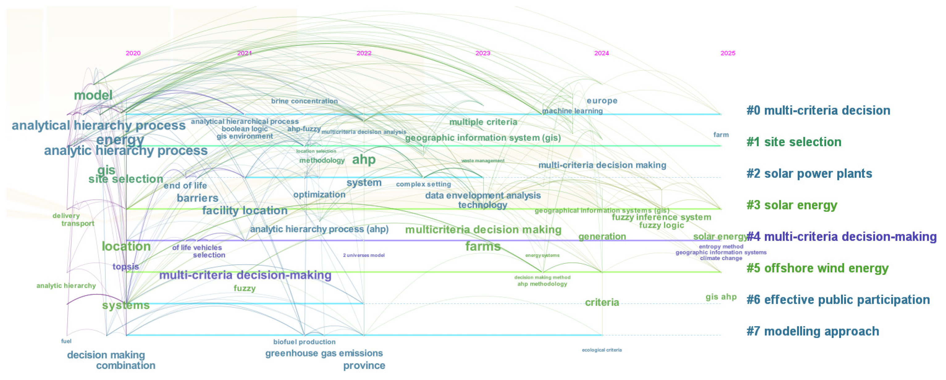
This study employed a systematic literature review (SLR) methodology and searched the Web of Science (WOS) core database using the keywords “industrial site selection” and “industrial facility site selection decision-making”, with the publication years are set from 1995 to 2025. Then, 4393 relevant articles were obtained. Through further manual screening, this study retained 149 articles that specifically addressed the location selection of industrial facilities and clearly explained the research methods adopted, for in-depth analysis and discussion. The keywords clustering result of the 149 articles is shown in Figure 1, which indicates that traditional OR methods like MCDM, Analytic Hierarchy Process (AHP), and Fuzzy AHP remain dominant. GIS is also widely adopted. The timeline analysis from 2020 to 2025 is shown in Figure 2, which reveals that AI technologies such as machine learning and knowledge graphs are rapidly emerging, highlighting a clear trend toward intelligent transformation in the field.
Besides the above bibliometric analysis, this study further employed systematic reading and content analysis to summarize and compare the methods used in the literature. Based on an in-depth understanding of the essence, technical pathways, and application characteristics of these methods, the industrial site selection methodologies were categorized into three main types for review: traditional OR methods, GIS-enabled methods, and AI methods.

3. Site Selection Criteria System

Establishing a scientific set of site selection criteria is the foundational step of the entire site selection process. Whether based on traditional industrial site selection models rooted in operations research or emerging methods leveraging artificial intelligence, their effective operation fundamentally relies on a system of qualitative or quantitative criteria. Even when dealing with end-to-end black-box models that do not depend on explicit rule inputs, the inherent preferences in their training data and the design of optimization objectives essentially represent an integration and internalization of site selection criteria.
This study aims to explore a general framework for industrial site selection from a methodological perspective. To ensure the systematic nature of subsequent analytical methods and provide decision-makers with a scientific reference, we conducted a literature review to systematically synthesize existing research. From the three dimensions of safety factors, economic factors, and socio-ecological–political factors, we summarized and refined a set of relatively universal core indicators for site selection (Table 1).

3.1. Safety Factors

Safety factors typically serve as critical exclusion criteria in site selection. Neglecting these factors can lead to disastrous consequences for the siting decision. In the context of industrial site selection, this paper primarily discusses safety factors under natural conditions, mainly categorized into geological and meteorological aspects.
From a geological perspective, a suitable slope is a key condition for the construction of most plant sites, as it can reduce construction and design costs [8]. The rock and soil structure is a crucial factor ensuring the stability of engineering facilities; areas with highly foliated and fractured metamorphic and sedimentary rocks should be avoided where possible, preferring areas with structurally intact igneous rocks to ensure regional stability [9]. Simultaneously, regarding topography and landforms, a comprehensive assessment of natural disaster risks such as landslides, mudflows, and floods is necessary, along with considering the potential impact of local microclimates on pollutant dispersion [10,11]. The distance from water sources is often used to ensure the operational safety of high-risk industrial facilities like chemical plants and nuclear power plants. Site selection must consider the needs of key emergency response links such as fire rescue and equipment cooling [12]. Seismic activity and distance from the coastline are used to mitigate the impact of major natural disasters like earthquakes, typhoons, and tsunamis. Relevant research suggests establishing a buffer zone of at least 1000 m from the coastline to effectively control risks [13].
From a meteorological standpoint, a stable meteorological environment is a crucial prerequisite for the long-term safe operation of industrial facilities. Compared to geological factors, meteorological indicators are more targeted. In siting practice, facilities should first be graded based on their own sensitivity to meteorological disasters, followed by consideration of factors like precipitation, temperature, and humidity [14]. For instance, ultra-high voltage transmission corridors and offshore wind turbines, which are extremely sensitive to wind loads and icing, require careful consideration of hurricanes and ice coating thickness. In contrast, chip fabrication plants, which primarily involve indoor processes, are more concerned with average humidity and the impact of dust particles on cleanliness. This section merely outlines the standard items that need reference during the site selection process.

3.2. Economic Factors

Economic factors are central to site selection decisions. For cost-sensitive enterprises, they directly affect long-term profitability, while for public sectors like the government, they relate to whether the project can achieve sustainable public operation. Here, this study subdivides economic factors into cost factors and revenue factors.
From the perspective of cost factors, industrial projects typically require large land areas, making land cost a rigid constraint that must be prioritized. Taking photovoltaic power stations as an example, evaluating land price in conjunction with local electricity demand can directly lead to significantly different siting conclusions [15]. Simultaneously, site selection decisions need to proactively consider the expandability of the land, reserving space for facility updates and capacity expansion within the project’s lifecycle. For projects with high electricity energy demands, the industrial electricity price is a key factor in their cost structure. Minor fluctuations in electricity prices can have a magnified effect on long-term operational costs, thereby directly impacting the project’s overall profitability [16]. For energy production industries like power stations, greater attention must be paid to the nearby transmission lines and their capacity to reduce installation and new infrastructure costs. One can opt for sites near existing transmission lines (e.g., within 600 m) with a voltage level equal to or higher than 35 kV [17]. Furthermore, for industrial production projects, the economic radius of transportation and labor supply are also two key strategic elements in site selection decisions. Regarding labor supply, it is necessary to comprehensively evaluate its cost competitiveness, the scale and structure of the local talent pool, and the completeness of relevant living and industrial supporting facilities [18]. At the transportation level, the economic radius directly affects logistics efficiency and cost. Sites should prioritize locations with high road accessibility to shorten delivery times and reduce operational expenses. Regarding this factor, Huang Ruopeng et al. proposed a bi-level hybrid model based on a heuristic algorithm, providing an effective tool for related analysis [19].
From a revenue perspective, site selection must closely align with the core revenue sources of different projects. For instance, the profitability of a photovoltaic power station highly depends on local solar irradiance, whereas wind power or marine energy facilities are primarily constrained by natural conditions such as wind speed, wind direction, and water depth. These factors directly determine the foundational structure form and construction costs, constituting the key boundaries for the project’s economic feasibility [20].

3.3. Socio-Ecological and Political Factors

Beyond the factors mentioned above, social, ecological, and policy factors also play crucial roles in site selection decisions, especially in modern project evaluation systems where these non-technical constraints often have a “veto power.” Social acceptance and legal compliance directly determine whether a project can proceed, while ecological sensitivity affects its sustainability and social responsibility image. Therefore, systematically evaluating such factors is essential for achieving scientific site selection. This section will analyze these from three dimensions: social, ecological, and legal and policy.
From a social perspective, public acceptance is the social foundation for the smooth implementation of a project. Public perception and attitudes towards industrial projects directly affect the project’s social license to operate. Especially for projects with environmental NIMBY (Not-In-My-Backyard) effects, such as chemical and energy projects, public communication and community engagement have become necessary components of preliminary feasibility studies [21]. Simultaneously, site selection must strictly avoid legally defined sensitive areas such as military restricted zones and ecological protection red lines, and maintain an appropriate distance from residential areas to mitigate the impact of environmental, noise, and safety risks on communities, thereby enhancing the project’s social compatibility [8,22]. Furthermore, for industrial facilities with radiological risks, the potential impact of radiation on surrounding communities and the environment must be a primary consideration in site selection and subject to prudent assessment [23].
From an ecological perspective, site selection should strive to avoid ecologically functional or high conservation value land types such as farmland, woodland, and grassland, strictly adhering to ecological protection red lines. In ecologically sensitive areas like nature reserves, rare flora and fauna habitats, and bird and fish migration corridors, project construction must strictly follow ecological protection requirements, implementing avoidance or ecological compensation measures when necessary [23]. Additionally, projects near water bodies should focus on assessing their impact on the water environment, strictly controlling pollutant discharge, and protecting watershed ecological health [22].
From a legal and policy perspective, compliance is the basic premise of site selection. Projects must comply with relevant national and local laws and regulations, especially rigid constraints in areas like land use approval, environmental impact assessment review, and industrial market access. The land ownership attribute directly relates to the project’s legality and the risk of subsequent ownership disputes, and must be clarified during the site selection stage. Furthermore, policy support also provides significant impetus for project advancement, including supporting measures such as land supply, fiscal and tax incentives, and approval green channels, all of which can significantly enhance the feasibility and comprehensive benefits of the chosen site [21].

4. Methods Map

4.1. Traditional Operations Research Methods for Industrial Site Selection

Industrial site selection, as a core issue in the spatial allocation of resources, fundamentally aims to achieve the synergistic optimization of technical feasibility, economic efficiency, and social benefits under multiple constraints. Traditional operations research methods address the NP-hard nature of the site selection problem through structured modeling [1]. primarily forming two technical paradigms: MCDM for quantifying unstructured indicators, and mathematical programming for optimizing hard constraints. MCDM techniques mainly include the Entropy Weight Method, Analytic Hierarchy Process (AHP), Best–Worst Method (BWM), Technique for Order Preference by Similarity to Ideal Solution (TOPSIS), and Elimination and Choice Translating Reality (ELECTRE); mathematical programming methods encompass Mixed Integer Linear Programming (MILP), Mixed Integer Nonlinear Programming (MINLP), chance-constrained programming, and Binary Integer Linear Programming (BILP).

4.1.1. Multi-Criteria Decision-Making

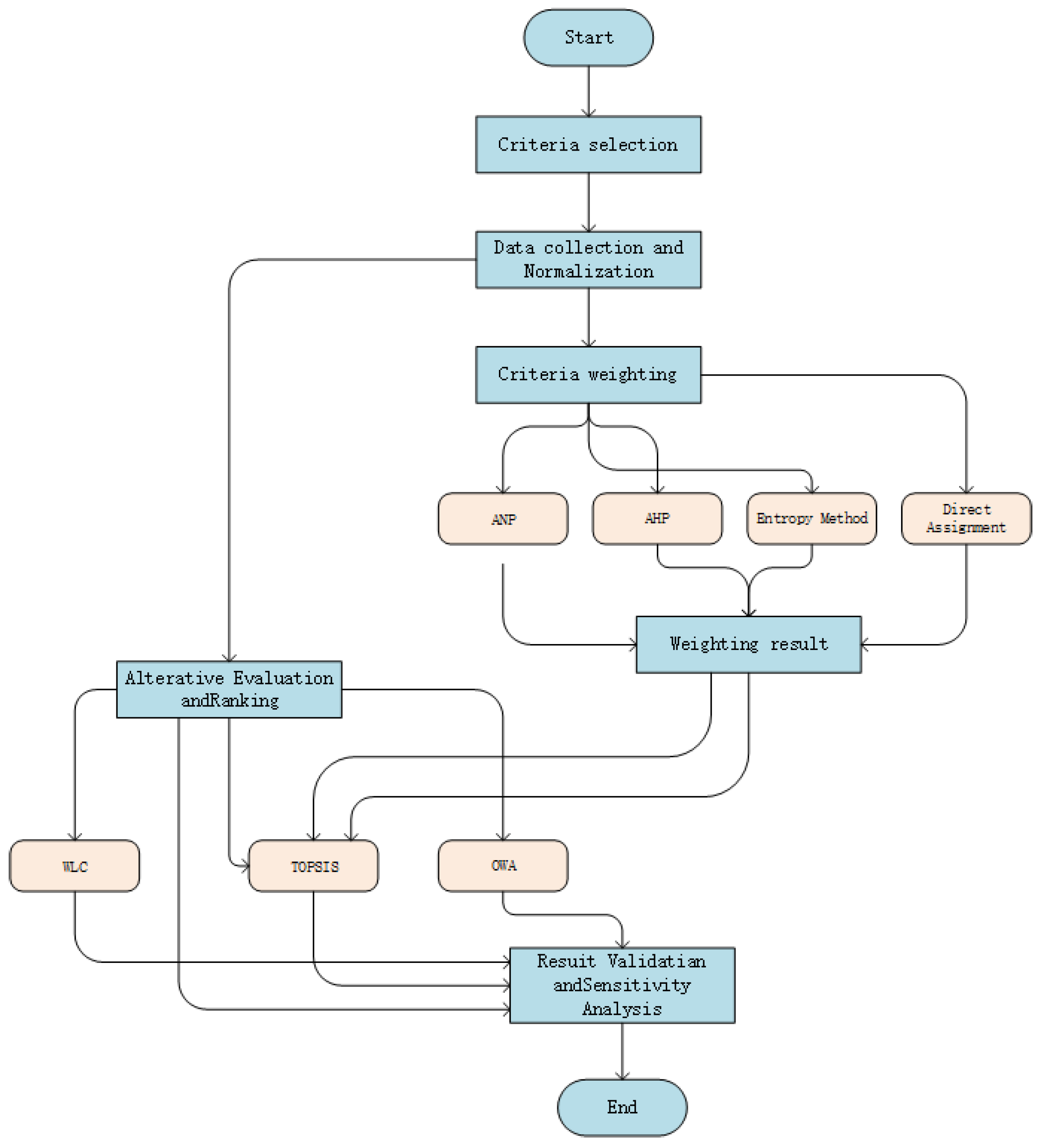
The MCDM framework decomposes the complex site selection problem into five interrelated core stages, ensuring the transparency and scientific rigor of the decision-making process [24], including criteria selection, data collection and normalization, determination of criteria weights, evaluation and ranking of alternatives, and result validation and sensitivity analysis. The overall flowchart is shown in Figure 3, which is referenced from [25].
(1)
Criteria Selection
This stage serves as the cornerstone of the entire decision-making process, aiming to establish a comprehensive and rational evaluation index system. The selection of criteria is primarily based on the literature review and expert opinions. Through a systematic review of previous studies, widely recognized core indicators can be identified. Standards are generally divided into two categories [26]: Exclusion Criteria, also referred to as restrictive or limiting criteria, are used to directly exclude areas entirely unsuitable for construction, such as legally designated nature reserves, military restricted zones, or technically infeasible areas (e.g., active fault zones, regions with insufficient wind speed). This step is often facilitated by GIS; Evaluation Criteria are employed to rank the merits of candidate sites that have passed the preliminary screening. Multi-dimensional attributes such as economic performance, technical feasibility, and environmental and social impact—for example, construction cost, operational efficiency, ecological sensitivity, and community acceptance—are typically encompassed. These attributes can be quantified and aggregated using Multi-Criteria Decision-Making methods to support the final site selection decision [20]. As systematically discussed in Chapter 3 of this paper, these criteria are commonly encountered in industrial site selection. Various MCDM methods are applicable for the integration and trade-off analysis of such criteria.
(2)
Data Collection and Normalization
Once the criteria are defined, site-specific data for each candidate location must be collected under every criterion. Because these data are heterogeneous in both source and unit (e.g., wind speed in m s−1, distance in km, cost in JPY), they must be normalized into dimensionless, comparable values. Three normalization techniques are commonly employed:
Reclassification: Widely used in GIS environments, continuous raster data (e.g., slope) are classified into discrete levels (e.g., highly suitable, suitable, unsuitable) and assigned ordinal scores (e.g., 5, 3, 1).
Fuzzy Membership Function: Each criterion value is mapped to the interval [0, 1], representing the degree of membership in the fuzzy set “most suitable.” A value of 0 indicates complete non-membership, whereas 1 indicates full membership.
Linguistic Variables and Fuzzy Theory: When handling qualitative or vague information (e.g., “high public acceptance”), linguistic terms (very high, high, medium, low) are converted into fuzzy numbers for computation.
(3)
Criteria Weighting
Appropriate weights reflecting the relative importance of each criterion in the final decision are assigned through the following methods:
AHP: The most widely applied subjective weighting technique. Experts perform pairwise comparisons of criteria to construct a judgment matrix, from which weights are derived and checked for consistency.
Analytic Network Process (ANP): An extension of AHP that accommodates interdependencies and feedback among criteria.
Entropy Method: An objective weighting approach in which the dispersion of data for each indicator determines its weight; greater dispersion implies higher information content and thus a larger weight.
Direct Assignment/Equal Weighting: In some studies, weights are assigned directly by experts or all criteria are given equal weights when information is insufficient.
(4)
Alternative Evaluation and Ranking
This stage is the core of MCDM, and the goal of this stage is to use a scientific aggregation model to integrate the importance of information scattered under various criteria, calculate a comprehensive evaluation value or priority order for each alternative solution, and generate a clear ranking. Most aggregation methods calculate comprehensive scores based on normalized standard values and their corresponding weights, while a few methods use different strategies, such as the Ordered Weighted Averaging (OWA) operator. The mainstream aggregation models are as follows:
Weighted Linear Combination (WLC): As one of the most intuitive and widely used methods, particularly in GIS, its composite score is calculated by directly summing the products of each criterion’s normalized value and its corresponding weight.
TOPSIS: This method ranks alternatives by evaluating their relative closeness to the ideal best solution and the ideal worst solution. Its core procedure involves first constructing a weighted decision matrix based on the normalized criterion values and their weights, then calculating the distance between each alternative and the positive or negative ideal solutions, and finally ranking them according to their relative closeness.
OWA: Unlike WLC or TOPSIS, the OWA operator incorporates the decision-maker’s risk attitude by reordering criterion values and assigning weights accordingly.
(5)
Result Validation and Sensitivity Analysis
To ensure the robustness and reliability of the decision outcome, validation is performed using the following:
Sensitivity Analysis: The most common technique, systematically varying criterion weights to determine whether the final ranking changes significantly; stability indicates model robustness.
Cross Model Comparison: Solving the same problem with different MCDM models (e.g., validating WLC results with TOPSIS) and assessing consistency.
Benchmarking Against Existing Sites: Comparing the model’s top ranked areas with locations of successfully implemented projects in the study region to verify model validity.
MCDM commonly includes the Analytic Hierarchy Process (AHP), the Preference Ranking Organization METHod for Enrichment Evaluations (PROMETHEE), the Technique for Order Preference by Similarity to Ideal Solution (TOPSIS), the ELimination and Choice Expressing REality (ELECTRE) method, and various improved models based on these methods.
PROMETHEE is widely applied in the site selection and evaluation of energy projects. Its core advantage lies in defining preference functions for different criteria, constructing the decision-maker’s preference structure in a flexible and robust manner. Compared to simple direct weighting methods, PROMETHEE can more precisely depict the trade-off relationships between criteria. This method can also be integrated with fuzzy set theory to effectively incorporate hard-to-quantify qualitative criteria into the decision-making framework, thereby enhancing the objectivity of the results and supporting in-depth sensitivity analysis [27,28].
AHP systematically decomposes complex site selection problems into multiple hierarchical levels by constructing a hierarchical structure. It determines the relative weights and rankings of various criteria and alternative solutions through pairwise comparisons of elements within each level. Compared to other MCDM methods, AHP has the advantages of intuitive principles and a clear computational process. However, the method also has certain limitations: its weight determination heavily relies on the subjective judgments of experts or decision-makers. Inappropriate expert team composition or cognitive biases can easily lead to results deviating from reality. Furthermore, when the number of included site selection criteria is excessive, AHP is prone to reduced model flexibility due to inconsistent judgment matrices, making it difficult to apply directly in engineering projects with high precision requirements or complex problem structures. Despite this, AHP still holds significant value in the preliminary screening stage of location selection, effectively narrowing down the candidate pool. Therefore, in current research, AHP is often used as a fundamental analytical tool in combination with other site selection methods to compensate for its shortcomings when applied independently [29].
TOPSIS ranks alternatives by calculating their relative distance to an idealized target. Its core concept involves defining a “positive ideal solution” and a “negative ideal solution”, where the former represents the set of optimal values across all criteria. The decision is made by approximating the positive ideal solution and distancing from the negative ideal solution. Also a deterministic algorithm, TOPSIS not only offers higher computational efficiency and greater scalability compared to the numerous comparisons required by AHP, but also imposes no limit on the number of alternatives that can be included. However, due to its inability to handle high degrees of fuzziness or qualitative criteria reliant on linguistic descriptions, practical site selection applications often utilize improved TOPSIS methods or a combination with fuzzy methods [30].
ELECTRE is a category of MCDM methods based on outranking relationships. Its core idea is to construct a graph of superiority relationships between alternatives through systematic pairwise comparisons. By introducing “concordance” and “discordance” tests, the method effectively simulates the “veto logic” present in human decision-making. In industrial site selection applications, the ELECTRE method is widely used in energy planning. For such problems, where disadvantages in certain critical indicators (e.g., seismic risk, distance from ecological protection zones) cannot be compensated for by advantages in other criteria, ELECTRE handles these “non-compensatory criteria” effectively by setting discordance thresholds. This provides a more comprehensive and reliable analytical perspective for complex decisions [31,32].
In practical applications, given the inherent complexity and multi-factorial nature of site selection problems, mainstream research typically integrates multiple MCDM techniques into a comprehensive decision-making framework. This integrated approach leverages the respective advantages of each method and enhances the scientific rigor of the overall evaluation. Hao Wang [33] proposed a WSR (Wu-li/Shi-li/Ren-li) framework. At the Wu-li level, objective hard criteria are applied for initial screening and exclusion; at the Shi-li level, entropy weighting and TOPSIS quantify the proximity of each candidate site to the ideal solution; at the Ren-li level, expert knowledge is introduced for fuzzy judgments, integrating the BWMwith interval type 2 fuzzy TOPSIS to produce a scientifically defensible score for emergency-medical-facility siting during public health crises. Abdulrahman and Farsat Heeto [34] quantify eight spatially heterogeneous indicators—including waste distribution and daylight availability—through an entropy weighted TOPSIS and GIS integrated approach, demonstrating livability advantages of western building clusters. To reconcile ranking discrepancies across methodologies, Ahmed El-Araby [35] used Spearman’s rank correlation coefficient to assess divergence among different MCDM outputs under entropy-based weights. Mingyu Li [36] developed a GIS–multi-criteria decision analysis (MCDA) hybrid model that first prescreens photovoltaic site candidates in East Africa via spatial clustering, then applies entropy weighted TOPSIS to quantify transmission cost constraints, overcoming the limitation of conventional GIS analyses that ignore economic factors. Saleh, Roqaia Farouk [37] applied fuzzy TOPSIS to handle linguistic ambiguities in airport siting, converting qualitative indicators such as “high noise pollution” into triangular fuzzy numbers (e.g., (70, 80, 90) dB) and using α-cut techniques to balance multiple objectives under EU sustainability criteria. Badi, Ibrahim [38] designed a Grey-CODAS (COmbinative Distance-based Assessment) model for data scarce African contexts. Grey relational analysis imputes missing indicators such as “route network density”, while a hybrid of Euclidean and Manhattan distances, moderated by a significance threshold, produces a closeness coefficient that designates the Moroccan airport as the North African hub.

4.1.2. Mathematical Programming Methods

Compared with MCDM approaches, mathematical programming constructs a rigorous siting model for problems sensitive to cost by explicitly defining decision variables, formulating an objective function, and prescribing a set of constraints. In facility location contexts, decision variables are typically encoded as (i) binary variables x_i ∈ {0,1} indicating whether a facility is to be established at candidate site i, or (ii) continuous variables y_ij ≥ 0 representing the allocation of resources from facility i to demand node j. The objective function pursues either cost minimization—e.g., aggregate construction and transportation expenditures—or benefit maximization—e.g., maximized service coverage. Constraints subsume essential considerations such as capacity limitations, technological feasibility, and logical interdependencies. In accordance with modeling requirements, four canonical paradigms are distinguished: MILP, MINLP, BILP, and chance-constrained programming, as summarized in Table 2.
MILP formulates both the objective function and the constraints as linear relationships, thereby enabling the joint optimization of discrete siting decisions and continuous resource allocations. Representative applications encompass transmission-network design in power systems—where logical constraints couple line capacities with substation siting—and logistics-hub location planning under capacity restrictions. In practice, MILP is frequently integrated with complementary techniques: Weijun Pan [39] proposed a two-phase hybrid algorithm that first applies X-means clustering to prescreen candidate drone station sites, then refines response time performance via an MILP model, and finally employs Bayesian optimization for the dynamic adjustment of service capacities. Under uncertainty, Fahad Saleh Alismail [40] developed a chance-constrained MILP model to determine the optimal siting and sizing of energy-storage systems for mitigating wind power fluctuations.
MINLP is used to model nonlinear technical relationships, such as the cubic dependence of wind turbine power output on wind speed in wind farms, and requires the integration of meta-heuristics to solve profit or energy maximization problems. Emin Sertaç Ari et al. [41] formulated an MINLP that simultaneously optimizes wind farm siting and turbine-specific parameters, with the objective of maximizing annual energy production E_prod. Arunabha Sen et al. [42] introduce a hierarchical decomposition into (i) a coarse-grained model that disregards transmission costs and attains an approximation guarantee for interval utility, and (ii) a fine-grained model that explicitly incorporates line costs and line capacities; the latter is cast as an integer linear program to achieve joint optimization of the transmission network and the facility locations.
Chance-constrained programming addresses stochastic parameters—such as demand volatility and renewable energy generation—by embedding probabilistic guarantees (e.g., Pr (storage absorption ≥ load) ≥ 95%) into a robust optimization framework, and has been widely applied to facility location and urban planning problems. Yong Liu et al. [43] confront the land use conflict at peri-urban lake districts under the dual pressures of urban sprawl and ecological conservation, and develop an Interval Chance-Constrained Linear Programming (ICCLP) model. The objective is to maximize Net Economic Benefit (NEB), while Total Environmental Capacity of water bodies (TEC) and Public Fiscal Investment (PFI) are formulated as principal chance constraints. In addition, sixteen deterministic constraints covering land suitability, structural proportions of land use, facility compatibility, and technological restrictions are incorporated. The resulting model is subsequently reformulated into an equivalent deterministic linear program, thereby furnishing a viable paradigm for applying chance-constrained programming to urban spatial siting decisions.
BILP is designed to handle bilinear terms in the objective function or constraints-typified by expressions such as z = x·y, where x and y denote facility coordination costs—under the condition that all decision variables are restricted to binary values, i.e., {0, 1}. In the siting context, strategic questions of “where to locate, how many facilities to deploy, and which demand nodes to serve” can be encoded as combinatorial optimization over binary variables, making BILP a natural modeling choice. G. Guastaroba [44] proposes a Kernel Search metaheuristic framework for the single source capacitated facility location problem. The core idea is to exploit the linear relaxation solution to identify a “promising” subset of variables—termed the kernel—and to iteratively solve a sequence of restricted subproblems defined on this kernel. Each sub-problem progressively augments the variable set and dynamically updates the kernel, thereby converging toward the global optimum. To enhance computational efficiency, the author further introduces two variable fixation variants that substantially reduce problem size and accelerate solution times.
Furthermore, the methodological arsenal of mathematical programming for siting problems continues to evolve. Lei Fan et al. [45] introduce a two-stage stochastic programming framework that employs scenario tree analysis to forecast demand volatility and robustly optimize the location of emergency medical supply warehouses; empirical validation demonstrates a 32% reduction in stock-out probability. Concurrently, geospatial intelligence techniques enhance decision robustness through the integration of remote sensing data. Adimasu Tafesse Gontte [46] argues that, when applying mathematical programming to urban siting in Africa, it is imperative to strengthen the assimilation of dynamic layers to adequately address climate related risks.
Table 2. Mathematical-programming-based approaches for industrial facility location.
Method CategoryDecision VariablesObjective FunctionKey Technical Constraints
MILP [41]Binary siting variables and continuous resource variablesLinear cost or coverage functionCapacity constraints, logical relationships
MINLP [47]Integer parameters and continuous flow variablesNonlinear technological benefit functionPhysical parameter coupling
Chance-Constrained Programming [48]Stochastic demand/supply variablesExpected cost minimizationProbabilistic feasibility threshold
BILP [44]Facility-interaction variables (xi xj t)Bilinear cost functionSynergistic interaction constraints

4.1.3. Challenges of MCDM and Mathematical Programming-Based Approaches

In multi-stakeholder games, where participants with divergent goals, information, and strategies interact strategically to maximize their own interests amid scarce and interdependent resources, MCDM is the method of choice owing to its inherent inclusiveness. Conversely, for capital-intensive infrastructures exhibiting pronounced cost elasticity, mathematical programming confers a pronounced Pareto-efficiency advantage. Arunabha Sen [33] empirically demonstrates the epistemic limitations inherent in multicriteria siting paradigms: their GIS-AHP architecture exhibits sub-optimal tractability when confronted with transmission network cost constraints, necessitating a recourse to a secondary mathematical-programming optimization phase. Md Imran Hasan Tusar et al. [49] corroborate that, despite its elevated computational complexity, mathematical programming yields statistically significant improvements in the accuracy of annual electricity generation estimations relative to simulation-based alternatives, thereby exhibiting superior alignment with long-term strategic planning horizons.
However, industrial siting decisions constitute a complex arena characterized by the reconciliation of multi stakeholder demands and acute cost sensitivity; in practice, the two methodological families are neither mutually exclusive nor operationally disjoint, but rather co-evolve in a nested symbiosis that jointly reinforces locational decision-making. Kyeong Ryong Kim et al. [50] adopt an AHP Integer Linear Programming (ILP) hybridization in which expert elicitation first secures compliance with hydrogen refueling station safety regulations, after which an integer linear program maximizes demand coverage. Baoku Du et al. [51] construct an interval valued intuitionistic fuzzy TOPSIS framework for AG600 maritime rescue bases, employing fuzzy entropy weighting to mitigate epistemic ambiguity in subjective assessments. The fuzzy TOPSIS paradigm advanced by Saleh, Roqaia Farouk et al. [37] and the grey CODAS (COmbinative Distance-based Assessment) approach proposed by Badi, Ibrahim et al. [38] form complementary archetypes: the former is calibrated for sustainability tradeoffs under the high data quality conditions prevalent in the EU, whereas the latter dismantles the “poor data, poor information” bottleneck typical of African contexts. Molina Gómez et al. [52] embed dynamic transformer rating (DTR) within an MILP formulation, increasing wind power grid integration capacity by 30%. Arunabha Sen et al. [33] devise an ILP model that, at the fine-grained optimization stage, simultaneously accounts for specific site costs and transmission costs, enforcing logical coherence between transmission line deployment and facility construction via constraints. Lei Fan et al. [45] extend the classical deterministic cost paradigm by integrating multistage stochastic programming, dynamically reallocating warehouse capacities in response to emergent demand shocks; its principal merit lies in transforming static cost optimization into risk-adaptive decision-making.
When tackling complex systems, hierarchical decoupling has become a key tactic: the vast, tightly coupled siting task is split along logical or functional layers into smaller, nested subsystems and subproblems that can be handled more or less on their own. MCDM or mathematical programming techniques are then applied tier-wise, and cross-layer coordination mechanisms propagate local optima toward global optimality, effectively reducing decision dimensionality and attenuating variable coupling. Khorasani Nejad et al. [53] develop a DSS that integrates constructability assessment with MCDA throughout the entire life cycle of bridge projects. Carlos M. Chang et al. [54] construct a Climate Informed Vulnerability Score (CIVS) and combine it with K-means clustering to quantify climate-driven risks for road infrastructure.
Although extant operations and research methodologies have yielded fruitful outcomes in site selection contexts, they continue to confront three overarching methodological bottlenecks: data dependency, subjective bias, and algorithmic efficiency. Adimasu Tafesse Gontte [46] demonstrates that paucity of geospatial data renders GIS-MCDA inoperative across Africa. Olcay Kalan et al. [55] reveal that ELECTRE and ratio analysis-based multi-objective optimization diverge in identifying the optimal location for a Turkish hub airport, evidencing decision ambiguities induced by subjective weight elicitation. While Badi & Ibrahim’s [38] grey CODAS (COmbinative Distance-based Assessment) attenuates data scarcity issues, its dual distance metric still incurs prohibitive computational complexity for large scale deployment. Christos N. Efrem et al. [1] emphasize the NP-hard nature of the BILP model for ground-station siting, necessitating branch-and-bound schemes to curtail combinatorial explosion.
Driven by continuous advances in artificial intelligence and geospatial technologies, traditional operations research-based location models are increasingly seeking extra disciplinary reinforcement to overcome extant methodological bottlenecks. The resultant technological trajectory is crystallizing into a tripartite breakthrough paradigm, summarized in Table 3: (i) AI-augmented decision accuracy enhancements exemplified by Weijun Pan et al. [39], who employed Bayesian optimization to dynamically adjust the service capacity of drone stations. (ii) Using GIS technology and a hybrid multi-criteria approach, Younes Noorollahi et al. [56] developed an automated decision framework that combines GIS-based Fuzzy-Boolean logic with the AHP to screen suitable sites for photovoltaic power plants in Khuzestan Province. (iii) By expanding the siting scope into a closed-loop framework spanning design, construction, and O&M, the DSS of Khorasani Nejad, Mansoureh et al. [53] embeds whole life cycle management, thereby transforming the traditional “stage-based” approach into an “iterative” life-cycle optimization and significantly boosting the resilience planning capability of complex systems in uncertain environments.

4.2. Geospatial Information Technology-Empowered Industrial Site Selection

As noted in Section 4.1.3, traditional operations research still faces several pressing challenges in the field of industrial site selection. Geospatial Information Technology (GIT), with its characteristics of full area coverage, real time updating, multi-dimensional integration, and spatial computability, systematically complements and upgrades conventional location models, thereby overcoming the three key bottlenecks of data dependency, subjective bias, and algorithmic efficiency. GIT-based industrial site selection methods are now widely applied in energy development, resource extraction, urban infrastructure construction, and other domains. By leveraging spatial data analysis and multi-criteria decision-making models, GIT enables decision-makers to optimize siting solutions in complex environments, achieving a balance among economic benefits, environmental protection, and social impact.

4.2.1. Empowering Traditional Operations-Research-Based Industrial Site Selection with Geospatial Information Technology

Zeki Mehmet Baskurt et al. [58] proposed a GIS-based WLC approach specifically for nuclear power plant siting. They classified the relevant factors into exclusion criteria and discretionary criteria to screen potential site areas. Their work on quantifying siting factors and devising weighting strategies within a GIS environment has provided important reference for subsequent nuclear siting studies. A. M. Abudeif et al. [59] employed GIS software (v. 10.1) to apply multi-criterial decision analysis: First, they built binary masks to screen out restricted zones. Guided by suitability criteria, they then applied Weighted Linear Combination with the AHP to rank locations, yielding a shortlist of viable sites. Wu [60] proposed a two-stage decision framework that integrates GIS with interval type 2 fuzzy PROMETHEE II (preference ranking organization method for enrichment evaluations II). In the first stage, GIS-based spatial analysis and predefined exclusionary criteria (e.g., seismic activity, population density, protected-area restrictions) are used to filter out unsuitable areas and generate a shortlist of candidate sites. In the second stage, interval type 2 fuzzy sets capture uncertainty, while an improved PROMETHEE II method ranks the candidates. This method dynamically assigns six distinct preference functions to the attribute criteria. A case study covering Hunan, Hubei, and Jiangxi provinces shows that site S8 is the best choice, thanks to strong government support, convenient fuel transport, and ample land. The study not only enriches the inland nuclear power plant siting database but also offers a theoretical reference for siting similar facilities.
Underpinned by GIT, the field of site selection has now crystallized into a three-dimensional theoretical framework of “MCDM–Mathematical Programming–Spatial Intelligence “. Its evolutionary logic has advanced from single-objective cost optimization (e.g., Md Imran Hasan Tusar’s wind power capacity maximization [33]) to multi-objective synergy (e.g., Hao Wang et al.’s balance of technical [54], managerial, and humanistic dimensions in healthcare facilities, and Kyeong Ryong Kim et al.’s integration of safety, economy, and coverage for hydrogen refueling stations [50]). It has further incorporated the sustainable development dimension (Saleh, Roqaia Farouk et al.’s [37] economic–environmental–social triple bottom line) and data robustness mechanisms (Badi, Ibrahim et al.’s [38] grey compensation), while embedding climate risk response mechanisms such as Carlos M. Chang’s CIVS scoring [54] and Fahad Saleh Alismail’s [40] accommodation of wind-power volatility. Mingyu Li et al.’s [36] quantification of spatial economic constraints and Lei Fan et al.’s [45] multistage risk adaptive model have collectively propelled siting decisions from static optimization toward dynamic robustness.
Future advances will require a deeper integration of geographic information systems and machine learning throughout the entire decision life cycle, transforming siting methodology from an empirical exercise into a scientific framework grounded in data-driven insight, model validation, and dynamic adaptation to meet the emerging challenges of climate change and complex social systems.

4.2.2. Core Technologies of Geospatial Information Technology in Industrial Site Selection

Geospatial information technologies have increasingly become pivotal in industrial site selection methodologies. From a core technology perspective, they can be disaggregated into three mutually nested and complementary components—GIS, remote sensing, and the Global Positioning System (GPS)—which collectively furnish indispensable decision support for industrial siting.
(1)
Geographic Information Systems
As a powerful tool for spatial data analysis, GIS has demonstrated outstanding value across numerous fields. In nuclear power plant siting, an increasing variety of selection methods are integrating GIS to markedly enhance the scientific rigor of the process and the precision of the results. GIS is a computer-based platform for managing and analyzing spatial data, capable of seamlessly integrating both spatial and attribute information. Through functions such as spatial database construction, spatial querying, overlay analysis, and buffer analysis, GIS supports comprehensive evaluation of multiple factors—terrain, land use, environmental constraints, and infrastructure in industrial site selection. The fundamental applications of GIS are shown in Figure 4.
Research shows that GIS has played a pivotal role in mine siting, wind farm siting, and the layout of urban infrastructure. Its spatial analysis capabilities can efficiently handle large scale, multi-source, multi-dimensional geospatial data, thereby improving the scientific soundness and rationality of siting alternatives. Malczewski [61] provides a systematic review of the integration of GIS with MCDA in siting studies, noting that GIS effectively fuses spatial and attribute information, thereby increasing the scientific rigor and transparency of siting decisions. The paper details multi-layer overlay methods for spatial data and weight-allocation mechanisms, emphasizing GIS’s wide application in resource development, environmental management, and urban planning.
(2)
Remote Sensing
Remote sensing (RS) refers to the acquisition of Earth surface information via aerial or satellite sensors. Distinguished by wide area coverage, high timeliness, and multispectral data capabilities, RS is extensively employed in the preliminary stages of industrial site selection for resource assessment, environmental monitoring, and land use change analysis. It rapidly furnishes spatial information on topography, land cover, vegetation status, water distribution, and urban expansion, enabling researchers to conduct comprehensive evaluations of candidate areas.
In industrial site selection, RS is commonly integrated with GIS to delineate areas suitable or unsuitable for development. For example, Weng [62] highlights RS’s central role in identifying impervious surfaces in urban areas—a critical input for siting urban infrastructure, transportation hubs, and industrial facilities. By extracting built up areas, water bodies, woodlands, and other land cover types from RS data, planners obtain scientific evidence to avoid ecologically sensitive zones, flood risk zones, or high-density urban districts.
Advances in RS image classification techniques have refined land use change monitoring, facilitating long term trend analyses of candidate sites. Jensen [63], in his seminal textbook, systematically summarizes RS image acquisition, preprocessing, classification, and interpretation methods, providing a universal technical framework for industrial site selection. The deep integration of RS with geospatial analysis enhances the scientific rigor, timeliness, and accuracy of site evaluations.
Beyond providing baseline imagery, RS supplies dynamic and quantifiable data on environment and resources that siting decisions require, especially when urban expansion, mountain development, or projects within ecologically sensitive regions are under consideration.
(3)
Global Navigation Satellite Systems
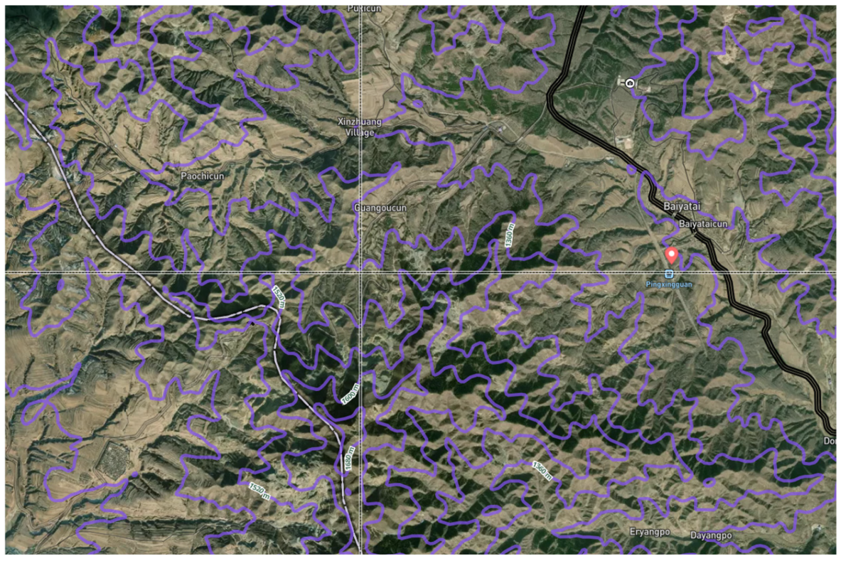
Global Navigation Satellite Systems (GNSSs), including GPS, GLONASS, Galileo, and others, provide high-precision spatial positioning services that are indispensable in industrial site selection, especially during field surveys, on-site measurements, and construction monitoring. The fundamental principles of GNSS are illustrated in Figure 5. GNSS receivers can acquire real time, centimeter-level coordinates of target locations via the updating of survey information. This real-time intelligent positioning workflow not only enhances data accuracy but also supports dynamic adjustments and risk identification during the siting phase.
GNSS and GIS can be jointly employed for survey planning. By evaluating GNSS signal coverage and obstruction effects on a sub-regional basis, and by coupling these assessments with GIS-based simulation analyses, survey tasks can be optimally deployed [64]. This approach avoids field deployments at sites with high occlusion or insufficient accuracy, thereby improving both measurement efficiency and data quality. In industrial surveying and structural monitoring, GNSS has become the standard technology for positioning and deformation monitoring of critical infrastructure such as bridges and tunnels. Offering all-weather, continuous, and high precision positioning capabilities, GNSS is now a foundational asset in modern surveying engineering [65].
The integrated application of GNSS and GIS not only streamlines on-site surveying workflows for site selection but also supplies high-quality spatial data for subsequent construction monitoring and safety assessments. This integration is therefore pivotal for advancing the scientific rigor and precision of industrial site selection.

4.2.3. Trends and Challenges in Geographic Information Technology Empowering Traditional Operations Research

GIT is playing an increasingly pivotal role in industrial siting. Through GIS, vast and complex geospatial datasets can be integrated with traditional operations-research models, yielding powerful capabilities for data fusion and visualization. This integration enables decision-makers to analyze and process siting problems more intuitively, comprehend spatial relationships and geographic characteristics, and thereby formulate more precise decisions [66]. Concurrently, the widespread adoption of big-data and machine-learning technologies has further enhanced both the efficiency and accuracy of siting decisions. By processing extensive historical and real-time datasets, machine-learning algorithms can forecast trend shifts and optimize siting alternatives, ensuring flexibility and adaptability in decision-making. The emergence of intelligent decision-support systems has rendered automated alternative evaluation and optimization feasible, furnishing decision-makers with tools for dynamic planning and scenario simulation [67]. These innovations allow decisions to be grounded not only in conventional economic and technical indicators, but also in environmental protection and social factors, thereby supporting sustainable development principles more comprehensively.
Nevertheless, the application of GIT is confronted by a series of challenges. Data quality and completeness are often the foremost concerns; obtaining high-quality, complete geospatial data remains subject to technical and legal barriers, while non-uniform data formats can lead to misinterpretation or loss of information [68]. Moreover, siting decisions entail multi-objective optimization problems that require complex trade-offs to satisfy technical, economic, and social constraints while reconciling the demands of diverse stakeholders. As project scales expand, the complexity of spatial data and operations-research models increases correspondingly. This complexity imposes computational challenges that necessitate novel algorithms and technologies to enhance computational efficiency and accuracy, thereby preventing decision delays or errors. Finally, privacy and security issues are unavoidable when handling sensitive geospatial information. While ensuring analytical efficacy, it is imperative to safeguard user privacy and address ethical concerns regarding data sharing and utilization [69].
GIT is propelling industrial siting toward greater precision and intelligence; yet, resolving the aforementioned challenges remains crucial for fully unlocking its potential. Through continuous technological innovation and strategic adaptation, GIT will continue to serve as an enabler in industrial siting.

4.3. Exploring AI-Based Site Selection Methods

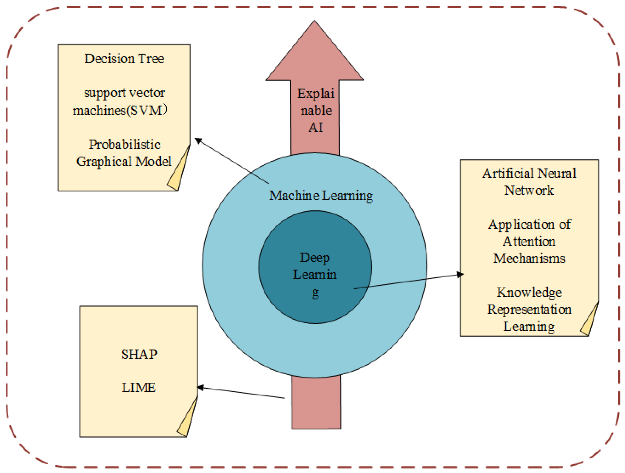
In recent years the rapid advances in information technology and artificial intelligence have begun to permeate the siting domain. Depending on the specific technical branch, these AI approaches can be broadly categorized into three strands: machine learning, deep learning, and explainable artificial intelligence. The structure of AI-based site selection is shown in Figure 6.

4.3.1. Machine Learning-Driven Industrial Site Selection Method

Machine learning is a technology that enables computers to improve their performance autonomously from data rather than through explicit human instructions. Its essence lies in algorithms that automatically discover patterns in data and use them to make predictions or decisions. In site selection studies, machine learning-driven modeling effectively tackles the traditional challenges of fusing multi-source heterogeneous data and fitting complex Nonlinear relationships, making it the preferred AI approach for siting tasks. For problems characterized by ample data and complex patterns, machine learning methods are a well-suited choice to strike a balance between decision quality and computational complexity. The mainstream techniques currently applied include decision tree-based models, support vector machines (SVM), probabilistic graphical models, and location allocation methods grounded in genetic algorithms.
(1)
Decision Tree-Based Site Selection Method
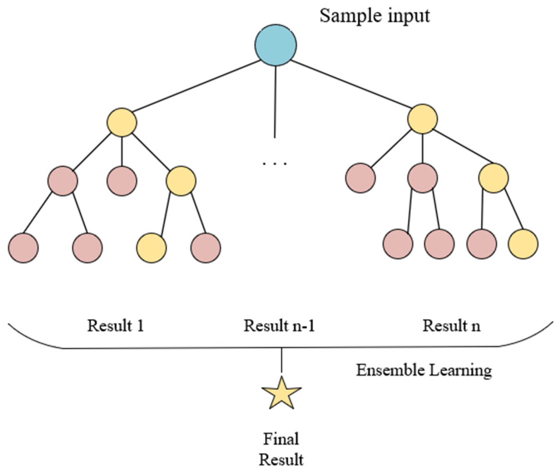
A decision tree is a family of machine learning models that make decisions in a tree-like structure. Its core idea is to recursively partition the data space and construct a set of if/then rules that approximate the target variable. In site selection research, the most commonly used tree-based models are CART, Random Forest (RF), and Extreme Gradient Boosting (XGBoost). The tree and forest structures are shown in Figure 7 and Figure 8, respectively.
To tackle electricity shortages in Punjab, Pakistan, Hafiz Adnan Ashraf et al. [70] employed 14 conditional factors and three machine learning algorithms, Random Forest, XGBoost, and Multilayer Perceptron (MPL), to screen all potential solar PV sites within the Bahawalnagar and Bahawalpur districts. Also using tree-based models, Atakan Bilgili [71] addressed the ambiguities and imprecision arising from artificially assigned weights in MCDM. To improve the reliability of wind farm siting, the authors built an automated decision framework based on seven ML models: Logistic Regression (LR), Naïve Bayes (NB), Classification and Regression Tree (CART), RF, Histogram-based Gradient Boosting (HGB), XGBoost, and Light Gradient Boosting Machine (LightGBM). SHapley Additive exPlanations (SHAP) was further introduced to interpret model outputs and render the decision process transparent.
For wind farm siting as well, Patrick D. Cerna [72] combined MCDM with SVM and trained a Random Forest model on variables such as wind speed, wind direction, topography, land use, population density, and slope, creating an effective approach to identifying high-potential areas.
Auliyani [73] assessed existing micro hydro power (MHP) projects by integrating geomorphic indices (Dd, Ns, TWI, and S), landslide hazard potential (RSI), climatic data (SPI), and socio-economic variables. A hybrid model that couples Geodetector with Recursive Feature Elimination–Random Forest (REF-RF) was developed to support decision-makers in the preliminary evaluation of MHP sites.
(2)
SVM-Based Site Selection Method
SVM entered the site selection arena through early needs for classifying remote sensing imagery (shown in Figure 9). Its core idea is to use kernel functions to map samples that are linearly inseparable in low dimensional space into a higher dimensional space where an optimal decision boundary can be found. Wenchuan Jing [74] proposed a fully automated GIS-based site selection workflow that couples SVM with geographic information extraction and classification. Notably, instead of the prevalent graph neural network (GNN) approach for image feature extraction, the author employs Sobel operators to compute image gradients, extracts edge information, and generates Histograms of Oriented Gradients (HOGs) as training inputs, an effective remedy for boundary feature extraction in small image scenes.
The selection of Emergency Shelter and Evacuation Sites (SSE) is a quintessential application of geospatial feature recognition and analysis. Traditional questionnaire-based AHP approaches are prone to bias and error caused by spatial limitations in survey areas. Amirmasoud Amiran et al. [75] explored machine learning alternatives aligned with SSE criteria, focusing on the high-seismic-risk city of San Francisco. They benchmarked SVM against KNN, logistic regression, Gaussian Process (GP), and artificial neural networks. The Gaussian Process Classifier (GPC) achieved the highest accuracy, while SVM still surpassed 0.7; logistic regression performed the worst. This comparison underscores that, for urban emergency siting tasks with limited samples and high-dimensional features, kernel-based methods remain competitive.
(3)
Probabilistic Graphical Model-based Industrial Site Selection Method
Probabilistic graphical models recast siting as an inference query: given evidence, they estimate the probability that a parcel is optimal. They rely on probability distributions, not deterministic rules, to handle geological uncertainty, regulatory shifts, and social preferences. Under conditions of high uncertainty in factors such as geological conditions, policy environment, or social acceptance, probabilistic graphical models and Bayesian methods can provide probability-informed site selection recommendations through modeling randomness.
Geothermal energy, a clean and renewable resource with vast potential, faces high costs and legal permit barriers caused by intrusive site investigations. Gianpaolo Coro et al. addressed this issue by employing a maximum entropy model together with geospatial data; using environmental vectors from existing geothermal plants and background points, they estimated the probability that any given location is suitable and produced the first global map of prospective geothermal site suitability [76].
Most current siting methods rely on quantitative analysis alone. Seyedmohsen Hosseini incorporated qualitative criteria as well, subdividing 11 subcriteria within economic, environmental, social, and technical dimensions [77]. He constructed a Bayesian network for electric vehicle charging station siting and used the model to evaluate and select the best site from four alternatives.

4.3.2. Deep Learning-Driven Industrial Site Selection Method

Deep learning employs deep neural networks with multiple nonlinear processing layers. Compared with the machine learning models discussed earlier, these architectures possess far stronger automatic feature learning capabilities: they can autonomously learn abstract, hierarchical representations directly from raw data. This gives deep learning a distinct advantage when dealing with high dimensional, unstructured data. As artificial intelligence technology continues to evolve, deep learning is emerging as the new growth curve in siting research. The principal techniques currently applied include artificial neural network-based siting methods, the use of attention mechanisms, and knowledge representation learning.
(1)
Artificial Neural Network-Based Site Selection Method
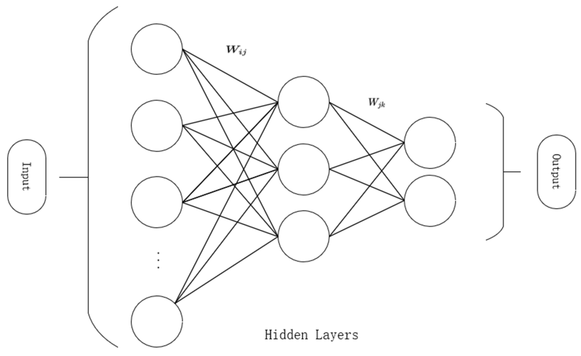
As early as 2007, Tahsin Alp Yanar [78] pioneered the use of artificial neural networks (ANNs) for siting: fuzzy datasets were first constructed with FuzzyCell and then fed into the network, successfully identifying relevant location patterns. Solar photovoltaic plants as representative industrial facilities are strongly influenced by infrastructure and meteorological factors common to most construction projects. Ouammi [79] employed an ANN to model the relationship among longitude, latitude, elevation, and solar irradiance using solar radiation data, enabling irradiation predictions and site selection for PV plants in Morocco. In Ae Yeo et al. [80] integrated nationwide, multi-source data, including topography and water availability from an Environment and Energy GIS (E-GIS) database, trained ten independent ANNs via the Levenberg Marquardt and scaled conjugate gradient algorithms, and ultimately produced suitability maps for different energy facility types. In practical applications, the ANN ensemble achieved an average R2 of 0.85, markedly outperforming conventional methods and confirming the effectiveness of nonlinear modeling.
As a highly scalable, simple, and efficient technique, ANN offers valuable insights for developing generic industrial siting methodologies. The basic structure of ANN is shown in Figure 10.
(2)
Application of Attention Mechanisms in Site Selection
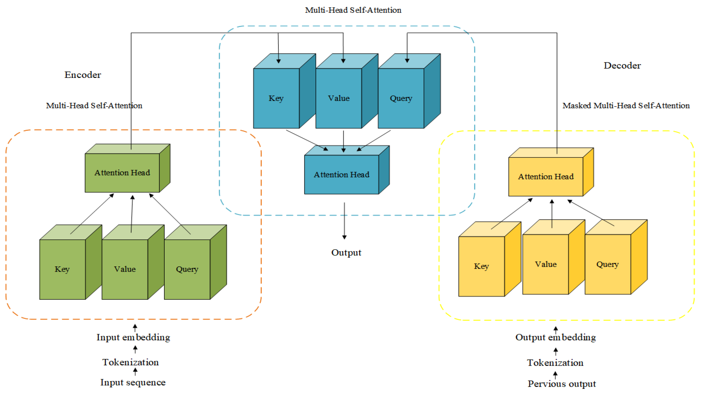
Attention mechanisms can dynamically focus on key spatial information while enhancing sensitivity to long distance correlations, effectively preventing “short sighted” decisions that often arise in multi-source heterogeneous siting data. The basic structure of attention mechanism is shown in Figure 11. Yanan Xu et al. [81] leveraged satellite and urban data to propose an attention-based neural network called AR2Net. The architecture comprises four components: a data embedding representation module, an attention-enhanced feature-extraction module, a location popularity predictor, and a loss function module. Experiments show that AR2Net outperforms baseline methods and demonstrate that using satellite imagery as raw input is both low-cost and effective.
Traditional base station siting not only involves selecting sites based on industrial feature suitability, but also incurs high computational costs from exhaustive searches over radio maps. Yi Zheng et al. [82] address this by introducing an end-to-end, transformer-based siting model named OSSN. Its three-part architecture consists of a Vision Transformer self-attention feature fusion block, an Information Fusion Pyramid Module (IFPM), and a recommendation module. By incorporating end-to-end parallelism and knowledge distillation, OSSN produces the optimal site in a single inference step within constrained areas. The model abandons the conventional two-stage serial pipeline, boosts inference efficiency, and substitutes knowledge distillation for brute force search, thereby improving decision-making robustness under complex conditions and offering a generalizable paradigm for related siting studies.
(3)
Application of Knowledge Representation Learning in Site Selection
Knowledge representation learning unifies heterogeneous entities in siting problems, such as geographic units, facilities, and demographic attributes, by encoding them into low-dimensional continuous vectors. This transformation converts traditionally discrete, symbolic siting knowledge into a differentiable numerical space, thereby liberating data-driven methods from the twin constraints of limited domain generalization and cumbersome feature engineering.
Inspired by the concept of knowledge graphs, Yu Liu [83] proposed a knowledge-driven siting model that integrates multi-source urban data into a semantic network, obviating the need for complex feature engineering. The model consists of two stages: knowledge graph construction and site selection. During construction, schema definition and fact extraction are performed separately; for site selection, the author devised a GNN-based encoder and a relation path-based decoder, enhancing both the richness of learned knowledge and the interpretability of the model. Tian Lan et al. [84] introduced Graph Convolutional Networks (GCNs) into the retail-store siting problem. They fused multi-source heterogeneous data, including public housing, bus and metro networks, and Points of Interest (POIs) to create the Land Transport Social Graph (LTSG) dataset, constructing a geo transport heterogeneous graph for knowledge representation. A two-layer GCN was then designed to simultaneously aggregate local features and interaction information propagated through the transport network. Experimental results showed that GCN models significantly outperformed local feature-only baselines (linear regression, Random Forest, and multilayer perceptron) on MSE, MAE, and MAPE, confirming the critical role of knowledge-representation networks in siting decisions.

4.3.3. Explainable AI-Driven Industrial Site Selection Method

Explainable Artificial Intelligence (XAI) is a critical branch of AI that brings transparency and credibility to siting decisions, thereby enhancing decision-making efficacy. In the siting domain, the two most frequently used XAI techniques are SHAP and LIME.
Mohammed Al Awadh et al. [85] addressed the gap between conventional approaches and XAI integration by developing a robust decision framework for landfill siting. The methodology first employs Multi-Criteria Decision-Making (MCDM) coupled with Fuzzy AHP to quantify scoring criteria. GIS, Self-Organizing Maps (SOM), and K-means clusteri ng are then used to generate a refined Landfill Siting Potential Index (LSPI) map. Finally, the team applied SHAP and LIME, two ensemble learning-based XAI techniques to conduct global and local analyses of feature importance, providing actionable guidance for management strategies. Alqahtani et al. [86] focused on mountainous residential construction. Using Fuzzy AHP, they built a suitability model incorporating sixteen parameters and employed a Deep Neural Network (DNN) guided by XAI for sensitivity analysis to evaluate each parameter’s impact on the optimal site decision. When applied to the ABHA region in Saudi Arabia, the model successfully identified 12.21% of the area as suitable for construction.
Existing studies confirm that AI and machine learning technologies have been widely adopted in the siting of diverse facilities, including medical centers, geothermal plants, solar PV farms, and micro hydro stations, significantly improving accuracy and efficiency by integrating multi-source data with advanced algorithms. As AI continues to evolve, future research must further explore how to organically integrate these cutting-edge technologies with traditional methods, enhancing siting efficiency and precision, boosting operational safety and reliability, and ultimately providing more comprehensive and effective solutions for industrial site selection siting.

4.3.4. Trends and Challenges in Applying Artificial Intelligence Methods to Site Selection

Existing research confirms that AI and machine learning technologies have been widely applied to site selection processes for various facilities, including medical facilities, geothermal power plants, solar photovoltaic power stations, and micro-hydropower stations. By integrating multi-source data and advanced algorithms, these technologies have significantly enhanced the accuracy and efficiency of site selection.
However, numerous challenges remain to be overcome in practical application. Firstly, concerning data quality and availability, multi-source heterogeneous data often suffers from issues such as inconsistent spatiotemporal resolution, high proportions of missing values, and significant labeling errors. Inputting such data directly into models without rigorous cleaning and validation can easily lead to systemic bias. Secondly, in high-dimensional, small-sample scenarios, the risk of model overfitting is particularly acute. When the training dataset cannot adequately cover the full spectrum of complex geological, meteorological, and socio-economic conditions, the model may yield overconfident predictions in unknown regions, consequently leading to site selection errors. Simultaneously, regulations and liability attribution remain unclear: should an AI-recommended plan lead to geological instability or NIMBY (Not In My Backyard) conflicts, there is still a lack of a legal framework defining how responsibility should be shared among developers, data providers, and decision-making bodies [69].
Therefore, as AI technology continues to evolve, future research needs to make concerted efforts in areas such as data governance, model robustness, and ethical compliance. Exploring how to organically integrate advanced technologies with traditional methods will be crucial to improve site selection efficiency and precision, enhance operational safety and reliability, and ultimately provide more comprehensive and effective solutions for nuclear power plant site selection.

5. Key Research Gaps and Practical Recommendations

5.1. Location Selection Methods Under Climate Challenges and Sustainable Development Imperatives Are Incomplete

Global warming is on the verge of breaching the 1.5 °C critical threshold, pushing the world’s climate towards its first tipping point. The climate crisis has evolved from a future forecast to a present reality demanding collective global action. As an interdisciplinary and systematic decision-making process, industrial location selection faces new challenges and requires fresh research perspectives against this backdrop of intensifying global climate crisis.
(1) From the perspective of location factors, multiple Earth system tipping points are nearing activation, whose cascading effects are giving rise to a series of emerging risk factors over short-to-medium-term timescales [87]. However, these factors have not yet been systematically identified or incorporated into location impact assessment frameworks. Developing climate-resilient location selection frameworks has thus become an urgent task.
(2) From the dimension of sustainable development, industrial location models fostering cross-national and regional cooperation represent an effective proactive response to climate challenges [88]. Decision-making for large-scale industrial project locations should systematically integrate a whole-chain perspective, from supply chains to markets, comprehensively evaluating resource efficiency and environmental impact. The aim is to achieve systematic optimization of the carbon footprint and promote the formation of an environmentally friendly, low-carbon, and resilient sustainable regional synergy.
(3) From the perspective of the siting objects themselves, priority should be given to incorporating climate-positive assets—such as clean energy bases, green manufacturing parks, and ecological infrastructure—into the scope of location planning. This approach leverages spatial layout as a strategic pivot to accelerate technological learning curves and unlock systemic decarbonization dividends.

5.2. The Deep Application of Artificial Intelligence Methods Awaits Exploration

As an emerging technological approach, AI demonstrates significant potential in advancing industrial location selection towards greater intelligence, multi-dimensionality, and efficiency. Nevertheless, substantial research gaps persist in this field.
(1)
Insufficient Data Usability, Validity, and Standardization: The depth of AI application in location decision-making is severely constrained by shortcomings in data availability, quality, and standardization. As a highly data-dependent methodology, AI models are extremely sensitive to the quality and consistency of input data. The field currently lacks credible, authoritative, and open datasets, while data from diverse sources exhibit significant discrepancies in format, precision, and timeliness. Therefore, research focused on establishing unified data standards and enhancing data governance and full lifecycle management is critically needed [89].
(2)
Inadequate Integration and Application of Multimodal Technology: Multimodal technologies remain underexplored in industrial location contexts. Multi-source information—such as imagery, text, remote sensing, GIS, and IoT data—can provide more comprehensive decision support for site selection. However, most current research remains confined to single data dimensions, lacking effective mechanisms for multimodal information synergy.
(3)
Challenge of Model “Hallucination” and Uncertainty: Furthermore, against the backdrop of prevalent “hallucinations” and inherent uncertainties in large models, ensuring the validity of location selection outcomes through technical means like explainable AI research or knowledge graphs remains a prominent shortcoming and a significant research gap.
(4)
Lack of Agent-Based Approaches and Toolchains: Finally, a significant gap exists in research on location selection based on intelligent agent technology and its associated toolchains. As integrated embodiments of AI capabilities, agents hold strong potential for translating location algorithms into practical applications. Currently, research is notably scarce on how to systematically integrate operations research optimization engines, geographic information systems, and large location models into a unified, operable intelligent agent framework to form end-to-end location applications.

5.3. Integrated Macro–Micro Full-Scale Location Method Frameworks Are Urgently Needed

Current research commonly suffers from a scale fragmentation problem: studies either focus on macro-level location selection based on economic and market factors, or are confined to micro-level site evaluation centered on engineering technology and geological conditions. There is a pronounced lack of frameworks that organically integrate these perspectives. However, industrial location selection is inherently a full-scale decision-making process spanning macro, meso, and micro levels, requiring the systematic integration of lifecycle elements ranging from supply chain layout and market reach to engineering construction and operational maintenance [90]. Consequently, developing an integrated full-scale framework capable of merging macro-strategic orientation with micro-level constraints represents a crucial yet underexplored breakthrough direction in this field.

5.4. Normative Recommendations for Future Research: A Checklist of Good Practices

Looking ahead, to promote the standardization and scientific development of the industrial site selection (ISS) field, and to enhance the credibility, reproducibility, and decision-making value of research outcomes, this study proposes the following “good practice” recommendations for future research reference:
(1)
Improve data reporting mechanisms: The most common limitation in site selection studies is data availability [89]. Research should comprehensively and transparently report the sources of data used, their spatiotemporal resolution, collection time, and key preprocessing steps (such as normalization and methods for handling missing data). This ensures the reproducibility of the study and supports the accumulation of knowledge in the field.
(2)
Strengthen sensitivity analysis: To ensure the robustness and usability of decision outcomes, sensitivity analysis or uncertainty quantification should be conducted for methods that rely on parameters or weights. In [91] the authors employed a set of spatially explicit sensitivity analysis methods to precisely quantify the uncertainty in land suitability assessment, providing a replicable paradigm for spatial site selection research.
(3)
Enhance the transparency of decision logic: For MCDM methods involving weights, the process of weight assignment and the basis for decisions should be disclosed. For “black-box” AI models, techniques from Explainable AI (XAI), such as SHAP or LIME, should be considered to interpret predictions and enhance the effectiveness of decision-making.
(4)
Standardize spatial layer management: When using geographic information tools like GIS for analysis, standardized management of spatial layers is essential [92]. This includes clearly reporting the coordinate system used, detailing reclassification rules and the core logic of overlay analysis, and documenting the rationale behind key parameter settings. This fundamentally ensures the accurate association and logical consistency between spatial data and attribute data.

6. Conclusions and Prospects

Industrial site selection is highly complex and requires the comprehensive application of interdisciplinary knowledge such as geology, ecology, economics, engineering, and law. This paper systematically reviews the workflows of industrial site selection under three representative disciplinary lenses. Traditional operations research, with multi-criteria decision-making and mathematical programming at its core, offers the advantages of logical rigor and strong interpretability but faces limitations such as computational complexity and oversimplification of reality. Geographic information technology achieves a breakthrough from abstraction to concreteness through spatial analysis and dynamic monitoring, yet its decision-making capabilities are limited and constrained by data quality. Artificial intelligence methods significantly enhance prediction accuracy with their powerful nonlinear fitting capabilities but are hindered by their “black-box” nature and data dependency. As a decisive step in translating projects from blueprint to ground, a single method can hardly tackle the full complexity of location selection issues, making the deep integration of multiple disciplines an inevitable trend in future industrial location research: The traditional operations research, centered on multi-criteria decision-making and mathematical programming, has evolved into an interdisciplinary domain that tightly couples geospatial technologies such as GIS, RS, and GNSS with artificial intelligence techniques, including machine learning and deep learning.
Driven by the rapid iteration of large-scale AI models, domain-specific applications are emerging through multimodal geoscience foundation models such as “Sigma Geography” (Kunyuan). However, systematic and in-depth research on the potential, mechanisms, and implementation pathways of such multimodal large models in site selection tasks remains scarce. Moving forward, it is imperative to address the key research gaps by strengthening the exploration of the “GIS–MCDM–AI” integrated framework, resolving challenges in data standardization and model interpretability, establishing a climate-resilient site evaluation system, and advancing integrated methodologies that bridge macro and micro scales. These efforts will lay a theoretical foundation for standardizing and advancing site selection methodologies, thereby supporting the development of comprehensive best practice guidelines.

Author Contributions

Conceptualization, X.M.; methodology, D.W. and Y.Z.; validation, X.M. and X.J.; data curation, D.W., Y.Z. and J.W.; writing—original draft preparation, D.W., and J.W.; writing—review and editing, Y.Z., X.M. and X.J.; visualization, J.W.; supervision, X.J.; project administration, X.M. and X.J.; funding acquisition, X.M. and X.J. All authors have read and agreed to the published version of the manuscript.

Funding

This research was funded by the Nuclear Power Plant Site Selection Integrated System Development Project of China Nuclear Power Engineering Co., Ltd. (No. KY24040) and the High-performance Computing Platform of China University of Geosciences Beijing.

Data Availability Statement

The data that support the findings of this study are available on request from the corresponding author, X.J.

Conflicts of Interest

Authors Dongbo Wang, Yubo Zhu, and Xidao Mao are employed by the company China Nuclear Power Engineering Co., Ltd. The remaining authors declare that the research was conducted in the absence of any commercial or financial relationships that could be construed as a potential conflict of interest. The authors declare that this study received funding from China Nuclear Power Engineering Co., Ltd. The funder was not involved in the study design, collection, analysis, interpretation of data, the writing of this article, or the decision to submit it for publication.

References

  1. Efrem, C.N.; Panagopoulos, A.D. Globally Optimal Selection of Ground Stations in Satellite Systems with Site Diversity. IEEE Wirel. Commun. Lett. 2020, 9, 1101–1104. [Google Scholar] [CrossRef]
  2. Fardi, K.; Ghanizadeh, G.; Bahadori, M.; Chaharbaghi, S.; Hosseini Shokouh, S.M. Location selection criteria for field hospitals: A systematic review. Health Promot. Perspect. 2022, 12, 131–140. [Google Scholar] [CrossRef]
  3. Al Garni, H.Z.; Awasthi, A. Solar PV power plants site selection: A review. Adv. Renew. Energ. Power Technol. 2018, 1, 57–75. [Google Scholar]
  4. Tang, X.; Zou, C.; Shu, C.; Zhang, M.; Feng, H. Research on site selection planning of urban parks based on POI and machine learning—Taking Guangzhou city as an example. Land 2024, 13, 1362. [Google Scholar] [CrossRef]
  5. Ayyildiz, E.; Erdogan, M. Literature analysis of the location selection studies related to the waste facilities within MCDM approaches. Environ. Sci. Pollut. Res. 2025, 32, 19574–19595. [Google Scholar] [CrossRef] [PubMed]
  6. Daskin, M. Network and discrete location: Models, algorithms and applications. J. Oper. Res. Soc. 1997, 48, 763–764. [Google Scholar] [CrossRef]
  7. Mahmud, N.; Habib, M.A. A comprehensive business location choice model leveraging machine learning in systematic choice set. Transp. Res. Rec. 2024, 2678, 1856–1871. [Google Scholar] [CrossRef]
  8. Brewer, J.; Ames, D.P.; Solan, D.; Lee, R.; Carlisle, J. Using GIS analytics and social preference data to evaluate utility-scale solar power site suitability. Renew. Energy 2015, 81, 825–836. [Google Scholar] [CrossRef]
  9. Ehsan, M.; Anees, M.T.; Bakar, A.F.B.A.; Ahmed, A. A review of geological and triggering factors influencing landslide susceptibility: Artificial intelligence-based trends in mapping and prediction. Int. J. Environ. Sci. Technol. 2025, in press. [Google Scholar] [CrossRef]
  10. Lin, J.; Chen, W.; Qi, X.; Hou, H. Risk assessment and its influencing factors analysis of geological hazards in typical mountain environment. J. Clean. Prod. 2021, 309, 127077. [Google Scholar] [CrossRef]
  11. Demirarslan, K.O. Effects of topographic variables on traffic-related pollutant concentrations: Comparison of AERMOD and CAL3QHCR models. Front. Environ. Sci. 2025, 13, 1577330. [Google Scholar] [CrossRef]
  12. International Atomic Energy Agency. Development and Application of Level 1 Probabilistic Safety Assessment for Nuclear Power Plants; IAEA Safety Standards Series No. SSG-3 (Rev. 1); International Atomic Energy Agency: Vienna, Austria, 2024; ISBN 978-92-0-130623-4. [Google Scholar]
  13. Kassim, M.; Heo, G.; Kessel, D.S. A systematic methodology approach for selecting preferable and alternative sites for the first NPP project in Yemen. Prog. Nucl. Energy 2016, 91, 325–338. [Google Scholar] [CrossRef]
  14. Yang, C.; Pan, A.; Li, J.; Wang, Y. Classification of units sensitive to meteorological disasters based on comprehensive emergency management. Zaihaixue 2018, 33, 27–31. [Google Scholar]
  15. Liao, Y.; Miao, S.; Fan, W.; Liu, X. A Novel Hybrid Fuzzy Comprehensive Evaluation and Machine Learning Framework for Solar PV Suitability Mapping in China. Remote Sens. 2025, 17, 2070. [Google Scholar] [CrossRef]
  16. Deng, N.; Wang, B.; He, L.; Liu, J.; Wang, Z. Does electricity price reduction bring a sustainable development of business: Evidence from fine-grained industrial electricity consumption data in China. J. Environ. Manag. 2023, 335, 117522. [Google Scholar] [CrossRef]
  17. Azman, M.N.A.; Ahamad, M.S.S.; Majid, T.A.; Yahaya, A.S.; Hanafi, M.H. Statistical evaluation of pre-selection criteria for industrialized building system (IBS). J. Civ. Eng. Manag. 2013, 19, S131–S140. [Google Scholar] [CrossRef]
  18. Perez-Ramos, J.L.; Herrera-Navarro, A.M.; Jimenez-Hernandez, H. Connecting Cities: Solving Optimal-Resource-Distribution Problem Using Critical Range Radius. Infrastructures 2025, 10, 249. [Google Scholar] [CrossRef]
  19. Bryden, I.G.; Couch, S.J. ME1—Marine energy extraction: Tidal resource analysis. Renew. Energy 2006, 31, 133–139. [Google Scholar] [CrossRef]
  20. Alves, C.J.P.; da Silva, E.J.; Müller, C.; Borille, G.M.R.; Guterres, M.X.; Arraut, E.M.; Peres, M.S.; dos Santos, R.J. Towards an objective decision-making framework for regional airport site selection. J. Air Transp. Manag. 2020, 89, 101888. [Google Scholar] [CrossRef]
  21. Swallow, S.K.; Opaluch, J.J.; Weaver, T.F. Siting noxious facilities: An approach that integrates technical, economic, and political considerations. Land Econ. 1992, 68, 283–301. [Google Scholar] [CrossRef]
  22. Kirkwood, C. A Case History of Nuclear Power Plant Site Selection. J. Oper. Res. Soc. 1982, 33, 353–363. [Google Scholar] [CrossRef]
  23. Yin, J.; Wei, Q.; Shao, D.; Luo, Z.; Ji, L. The impacts of power transmission and transformation projects on ecological corridors and landscape connectivity: A case study of Shandong province, China. Sci. Rep. 2025, 15, 6709. [Google Scholar] [CrossRef] [PubMed]
  24. Khanlari, A.; Alhuyi Nazari, M. A review on the applications of multi-criteria decision-making approaches for power plant site selection. J. Therm. Anal. Calorim. 2022, 147, 4473–4489. [Google Scholar] [CrossRef]
  25. Lenton, T.M.; Milkoreit, M.; Willcock, S.; Abrams, J.F.; Armstrong McKay, D.I.; Buxton, J.E.; Donges, J.F.; Loriani, S.; Wunderling, N.; Alkemade, F.; et al. The Global Tipping Points Report 2025; University of Exeter: Exeter, UK, 2025. [Google Scholar]
  26. Yousefi, H.; Motlagh, S.G.; Montazeri, M. Multi-Criteria Decision-Making System for Wind Farm Site-Selection Using Geographic Information System (GIS): Case Study of Semnan Province, Iran. Sustainability 2022, 14, 7640. [Google Scholar] [CrossRef]
  27. Tong, L.; Pu, Z.; Chen, K.; Yi, J. Sustainable maintenance supplier performance evaluation based on an extend fuzzy PROMETHEE II approach in petrochemical industry. J. Clean. Prod. 2020, 273, 122771. [Google Scholar] [CrossRef]
  28. Wang, L.; Gao, R.X.; Nam, H.O.; Jang, H.; Ko, W.I.; Zhang, C.-D.; Ye, G.-A.; Jing, W.-H. Sustainability-oriented prioritization of nuclear fuel cycle transitions in China: A holistic MCDM framework under uncertainties. Nucl. Sci. Tech. 2024, 35, 158. [Google Scholar] [CrossRef]
  29. Reisi, M.; Afzali, A.; Aye, L. Applications of analytical hierarchy process (AHP) and analytical network process (ANP) for industrial site selections in Isfahan, Iran. Environ. Earth Sci. 2018, 77, 537. [Google Scholar] [CrossRef]
  30. Peng, H.-M.; Wang, X.-K.; Wang, T.-L.; Liu, Y.-H.; Wang, J.-Q. A Multi-Criteria Decision Support Framework for Inland Nuclear Power Plant Site Selection under Z-Information: A Case Study in Hunan Province of China. Mathematics 2020, 8, 252. [Google Scholar] [CrossRef]
  31. Erdin, C.; Ozkaya, G. Turkey’s 2023 Energy Strategies and Investment Opportunities for Renewable Energy Sources: Site Selection Based on ELECTRE. Sustainability 2019, 11, 2136. [Google Scholar] [CrossRef]
  32. Govindan, K.; Jepsen, M.B. ELECTRE: A comprehensive literature review on methodologies and applications. Eur. J. Oper. Res. 2016, 250, 1–29. [Google Scholar] [CrossRef]
  33. Wang, H.; Luo, P.; Wu, Y. Research on the location decision-making method of emergency medical facilities based on WSR. Sci. Rep. 2023, 13, 18011. [Google Scholar] [CrossRef] [PubMed]
  34. Abdulrahman, F.H.; Foroughi, S. Investigating livability of residential sectors using TOPSIS model and GIS: A case study: South Malta neighborhood in Duhok City, Iraq. AIP Conf. Proc. 2023, 2651, 020051. [Google Scholar] [CrossRef]
  35. El-Araby, A.; Sabry, I.; El-Assal, A. A Comparative Study of Using MCDM Methods Integrated with Entropy Weight Method for Evaluating Facility Location Problem. Oper. Res. Eng. Sci. Theory Appl. 2022, 5, 121–138. [Google Scholar] [CrossRef]
  36. Li, M.; Lu, Y.; Wu, Q.; Ma, C.; Gao, J. Study on Risk Assessment of Project Site Selection Decision. In Proceedings of the 6th International Seminar on Education, Management and Social Sciences, Chongqing, China, 28–30 December 2022. [Google Scholar]
  37. Saleh, R.F.; Kaml, B.S.; Hameed, L.M. Utilizing Fuzzy TOPSIS for Sustainable Development: A Case Study in Selection of Airport Location. J. Inf. Syst. Eng. Manag. 2024, 9, 30116. [Google Scholar] [CrossRef]
  38. Badi, I.; Alosta, A.; Elmansouri, O.; Abdulshahed, A.; Elsharief, S. An application of a novel grey-codas method to the selection of hub airport in north africa. Decis. Mak. Appl. Manag. Eng. 2023, 6, 18–33. [Google Scholar] [CrossRef]
  39. Pan, W.; Gao, J.; Wang, X.; Zuo, Q.; Tan, S. Urban drone stations siting optimization based on hybrid algorithm of MILP and machine learning. Heliyon 2024, 10, e32928. [Google Scholar] [CrossRef]
  40. Alismail, F.S. Chance Constraints Optimal Planning Strategy of Energy Storage Systems and Tie-Lines under Wind Power Uncertainties to Improve the Reliability. Arab. J. Sci. Eng. 2021, 46, 9935–9944. [Google Scholar] [CrossRef]
  41. Ari, E.S.; Gencer, C. Proposal of a novel mixed integer linear programming model for site selection of a wind power plant based on power maximization with use of mixed type wind turbines. Energy Environ. 2020, 31, 825–841. [Google Scholar] [CrossRef]
  42. Sen, A.; Sumnicht, C.; Choudhuri, S.; Adeniye, S.; Sen, A.B. Methodologies for Selection of Optimal Sites for Renewable Energy Under a Diverse Set of Constraints and Objectives. In Proceedings of the Hawaii International Conference on System Sciences, Honolulu, HI, USA, 3–6 January 2023. [Google Scholar]
  43. Liu, Y.; Qin, X.; Guo, H.; Zhou, F.; Wang, J.; Lv, X.; Mao, G. ICCLP: An Inexact Chance-Constrained Linear Programming Model for Land-Use Management of Lake Areas in Urban Fringes. Environ. Manag. 2007, 40, 966–980. [Google Scholar] [CrossRef]
  44. Guastaroba, G.; Speranza, M.G. A heuristic for BILP problems: The Single Source Capacitated Facility Location Problem. Eur. J. Oper. Res. 2014, 238, 438–450. [Google Scholar] [CrossRef]
  45. Fan, L.; Karimi, N.; Feylizadeh, M.R.; Khorshidnia, M.; Li, Y. Location-Allocation of a Biorefinery Based on Linguistic Mixed Integer Nonlinear Mathematical Modeling. IEEE Access 2025, 13, 83373–83393. [Google Scholar] [CrossRef]
  46. Gontte, A.T. Review on Potential Urban Development Site Selection Using Geospatial-Based Multi-Criteria Decision Analysis (MCDA) Techniques in the Context of Ethiopia. Sci. Front. 2024, 5, 102–109. [Google Scholar] [CrossRef]
  47. Lira-Barragán, L.F.; Ponce-Ortega, J.M.; Serna-González, M.; El-Halwagi, M.M. An MINLP model for the optimal location of a new industrial plant with simultaneous consideration of economic and environmental criteria. Ind. Eng. Chem. Res. 2011, 50, 953–964. [Google Scholar] [CrossRef]
  48. Luo, B.; Huang, G.; Chen, J.; Zhang, X.; Zhao, K. A chance-constrained small modular reactor siting model—A case study for the Province of Saskatchewan, Canada. Renew. Sustain. Energy Rev. 2021, 148, 111320. [Google Scholar] [CrossRef]
  49. Tusar, M.I.H.; Sarker, B.R. Location and turbine parameter selection for offshore wind power maximization. Wind Eng. 2023, 47, 833–851. [Google Scholar] [CrossRef]
  50. Kim, K.R.; Cho, J.H. Prioritization and Optimal Location of Hydrogen Fueling Stations in Seoul: Using Multi-Standard Decision-Making and ILP Optimization. Processes 2023, 11, 831. [Google Scholar] [CrossRef]
  51. Du, B.; Xiong, W.; Wang, H.; Sun, C.; Du, H. AG600 Maritime Base Location Decision Based on the Interval Intuitionistic Fuzzy TOPSIS Method. IEEE Access 2022, 10, 82483–82492. [Google Scholar] [CrossRef]
  52. Molina Gómez, A.; Morozovska, K.; Laneryd, T.; Hilber, P. Optimal sizing of the wind farm and wind farm transformer using MILP and dynamic transformer rating. Int. J. Electr. Power Energy Syst. 2022, 136, 107645. [Google Scholar] [CrossRef]
  53. Khorasani Nejad, M.; Rashidi, M.; Mousavi, V. Application of Hybrid MCDA Tools for Constructability Review in Infrastructure Projects: A Bridge Case Study. Appl. Sci. 2025, 15, 3923. [Google Scholar] [CrossRef]
  54. Chang, C.M.; Hossain, A. A Climate Adaptation Asset Risk Management Approach for Resilient Roadway Infrastructure. Infrastructures 2024, 9, 226. [Google Scholar] [CrossRef]
  55. Kalan, O.; Işık, M.; Yüksel, F.Ş. An Application Using ELECTRE and MOORA Methods in the Selection of International Airport Transfer Center (Hub) in Türkiye. Appl. Sci. 2024, 14, 7678. [Google Scholar] [CrossRef]
  56. Noorollahi, Y.; Senani, A.G.; Fadaei, A.; Simaee, M.; Moltames, R. A framework for GIS-based site selection and technical potential evaluation of PV solar farm using Fuzzy-Boolean logic and AHP multi-criteria decision-making approach. Renew. Energy 2022, 186, 89–104. [Google Scholar] [CrossRef]
  57. Benzaghta, M.; Geraci, G.; López-Pérez, D.; Valcarce, A. Cellular network design for UAV corridors via data-driven high-dimensional Bayesian optimization. IEEE Trans. Wirel. Commun. 2025, 24, 7530–7545. [Google Scholar] [CrossRef]
  58. Baskurt, Z.M.; Aydin, C.C. Nuclear power plant site selection by weighted linear combination in GIS environment, Edirne, Turkey. Prog. Nucl. Energy 2018, 104, 85–101. [Google Scholar] [CrossRef]
  59. Abudeif, A.M.; Moneim, A.A.; Farrag, A.F. Multicriteria decision analysis based on analytic hierarchy process in GIS environment for siting nuclear power plant in Egpty. Ann. Nucl. Energy 2015, 75, 682–692. [Google Scholar] [CrossRef]
  60. Wu, Y.; Liu, F.; Huang, Y.; Xu, C.; Zhang, B.; Ke, Y.; Jia, W. A two-stage decision framework for inland nuclear power plant site selection based on GIS and type-2 fuzzy PROMETHEE II: Case study in China. Energy Sci. Eng. 2020, 8, 1941–1961. [Google Scholar] [CrossRef]
  61. Malczewski, J. GIS-based multicriteria decision analysis: A survey of the literature. Int. J. Geogr. Inf. Sci. 2006, 20, 703–726. [Google Scholar] [CrossRef]
  62. Weng, Q. Remote sensing of impervious surfaces in the urban areas: Requirements, methods, and trends. Remote Sens. Environ. 2012, 117, 34–49. [Google Scholar] [CrossRef]
  63. Jensen, J.R. Remote Sensing of the environment: An earth resource perspective. In Remote Sensing of the Environment: An Earth Resource Perspective, 2nd ed.; Pearson Education India: Delhi, India, 2009; pp. 1–672. [Google Scholar]
  64. Bartoněk, D.; Opatřilová, I. The use of GIS technology for planning of GNSS measurement. Adv. Intell. Syst. 2014, 53, 281–294. [Google Scholar]
  65. Yi, T.H.; Li, H.N.; Gu, M. Recent research and applications of GPS-based monitoring technology for high-rise structures. Struct. Control Health Monit. 2013, 20, 649–670. [Google Scholar] [CrossRef]
  66. Aronoff, S. Geographic Information Systems: A Management Perspective. In Geographic Information Systems: A Management Perspective, 1st ed.; WDL Publications: Ottawa, ON, Canada, 1993; pp. 1–294. [Google Scholar]
  67. Turban, E.; Aronson, J.E. Decision Support Systems. In Decision Support Systems, 1st ed.; Prentice Hall: Upper Saddle River, NJ, USA, 2001; pp. 1–867. [Google Scholar]
  68. Batini, C.; Scannapieco, M. Data Quality: Concepts, Methodologies and Techniques. In Data Quality: Concepts, Methodologies and Techniques; Springer: Berlin, Germany, 2006; pp. 1–121. [Google Scholar]
  69. Burke, S.A.; Akhtar, A. The shortcomings of artificial intelligence: A comprehensive study. Int. J. Libr. Inf. Sci. 2023, 15, 8–13. [Google Scholar] [CrossRef]
  70. Ashraf, H.A.; Li, J.; Li, Z.; Sohail, A.; Ahmed, R.; Butt, M.H.; Ullah, H. Geographic Information System and Machine Learning Approach for Solar Photovoltaic Site Selection: A Case Study in Pakistan. Processes 2025, 13, 981. [Google Scholar] [CrossRef]
  71. Bilgili, A.; Arda, T.; Kilic, B. Explainability in wind farm planning: A machine learning framework for automatic site selection of wind farms. Energy Convers. Manag. 2024, 309, 118441. [Google Scholar] [CrossRef]
  72. Cerna, P.; Evangelista, R.; Castillo, C.; Muallam-Darkis, J.; Velasco, M.A.; Legaspi, J.; Darkis, A.; Gatdula, M. Wind power plant site selection using integrated machine learning and multiple-criteria decision making technique. E3S Web Conf. 2023, 405, 02030. [Google Scholar] [CrossRef]
  73. Auliyani, D.; Setiawan, O.; Nugroho, H.Y.S.H.; Wahyuningrum, N.; Hardjo, K.S.; Videllisa, G.A.; Insani, A.F.; Lailiyya, L.N.; Istiqomatunnisa; Ardiyanti, N. Micro hydro power site characterization in Indonesia: Variable optimization for site selection using GeoDetector and RFE-Random Forest. IOP Conf. Ser. Earth Environ. Sci. 2024, 1357, 012025. [Google Scholar] [CrossRef]
  74. Jing, W.; Qiang, W.; Yang, J.; Wang, T.; Li, G. Automatic Geographic Information Classification Method Based on SVM for Site Selection of Stretch Field. J. Phys. Conf. Ser. 2023, 2508, 012051. [Google Scholar] [CrossRef]
  75. Amiran, A.; Behnam, B.; Seyedin, S. AI-Based model for site-selecting earthquake emergency shelters. Sci. Rep. 2024, 14, 29033. [Google Scholar] [CrossRef] [PubMed]
  76. Coro, G.; Trumpy, E. Predicting geographical suitability of geothermal power plants. J. Clean. Prod. 2020, 267, 121874. [Google Scholar] [CrossRef]
  77. Hosseini, S.; Sarder, M.D. Development of a Bayesian network model for optimal site selection of electric vehicle charging station. Int. J. Electr. Power Energy Syst. 2019, 105, 110–122. [Google Scholar] [CrossRef]
  78. Yanar, T.A.; Akyüre, Z. Artificial Neural Networks as a Tool for Site Selection Within GIS; Geodetic and Geographic Information Technologies, Natural and Applied Sciences: Ankara, Turkey, 2007; p. 6531. [Google Scholar]
  79. Ouammi, A.; Zejli, D.; Dagdougui, H.; Benchrifa, R. Artificial neural network analysis of Moroccan solar potential. Renew. Sustain. Energy Rev. 2012, 16, 4876–4889. [Google Scholar] [CrossRef]
  80. Yeo, I.-A.; Yee, J.-J. A proposal for a site location planning model of environmentally friendly urban energy supply plants using an environment and energy geographical information system (E-GIS) database (DB) and an artificial neural network (ANN). Appl. Energy 2014, 119, 99–117. [Google Scholar] [CrossRef]
  81. Xu, Y.; Shen, Y.; Zhu, Y.; Yu, J. AR2Net: An attentive neural approach for business location selection with satellite data and urban data. ACM Trans. Knowl. Discov. Data 2020, 14, 20. [Google Scholar] [CrossRef]
  82. Zheng, Y.; Liao, C.; Wang, J.; Liu, S. A Transformer-Based Network for Unifying Radio Map Estimation and Optimized Site Selection. In Proceedings of the 2024 IEEE International Conference on Acoustics, Speech, and Signal Processing Workshops (ICASSPW), Seoul, Republic of Korea, 14–19 April 2024. [Google Scholar]
  83. Liu, Y.; Ding, J.; Li, Y. Knowledge-driven Site Selection via Urban Knowledge Graph. arXiv 2021, arXiv:2111.00787. [Google Scholar] [CrossRef]
  84. Lan, T.; Cheng, H.; Wang, Y.; Wen, B. Site Selection via Learning Graph Convolutional Neural Networks: A Case Study of Singapore. Remote Sens. 2022, 14, 3579. [Google Scholar] [CrossRef]
  85. Al Awadh, M.; Mallick, J. A decision-making framework for landfill siteselection in Saudi Arabia using explainable artificial intelligence and multi-criteria analysis. Environ. Technol. Innov. 2024, 33, 103464. [Google Scholar] [CrossRef]
  86. Alqahtani, D.; Mallick, J.; Alqahtani, A.M.; Talukdar, S. Optimizing Residential Construction Site Selection in Mountainous Regions Using Geospatial Data and eXplainable AI. Sustainability 2024, 16, 4235. [Google Scholar] [CrossRef]
  87. Talmor, I. Implementing a multi-criteria decision-making approach to a new party’s election campaign—A case study. MethodsX 2021, 8, 101328. [Google Scholar] [CrossRef]
  88. Zhang, J.; Zhao, L.; Jin, L.; Zhu, C.; Wang, H.; Wang, L. Optimizing Regional CCUS Clusterization Deployment for Multi-industrial Sectors: A Carbon Neutrality Pathway for Emission-intensive Region. Carbon Capture Sci. Technol. 2025, 17, 100495. [Google Scholar] [CrossRef]
  89. Kuhaneswaran, B.; Chamanee, G.; Kumara, B.T.G.S. A comprehensive review on the integration of geographic information systems and artificial intelligence for landfill site selection: A systematic mapping perspective. Waste Manag. Res. 2025, 43, 137–159. [Google Scholar] [CrossRef]
  90. Deichmann, U.; Lall, S.V.; Redding, S.J.; Venables, A.J. Industrial Location in Developing Countries; World Bank: Washington, DC, USA, 2008; pp. 219–246. [Google Scholar]
  91. Ligmann-Zielinska, A.; Jankowski, P. Spatially-explicit integrated uncertainty and sensitivity analysis of criteria weights in multicriteria land suitability evaluation. Environ. Model. Softw. 2014, 57, 235–247. [Google Scholar] [CrossRef]
  92. Awange, J.; Kiema, J.B. Environmental Geoinformatics; Springer: Berlin/Heidelberg, Germany, 2013; Volume 10, pp. 978–983. [Google Scholar]
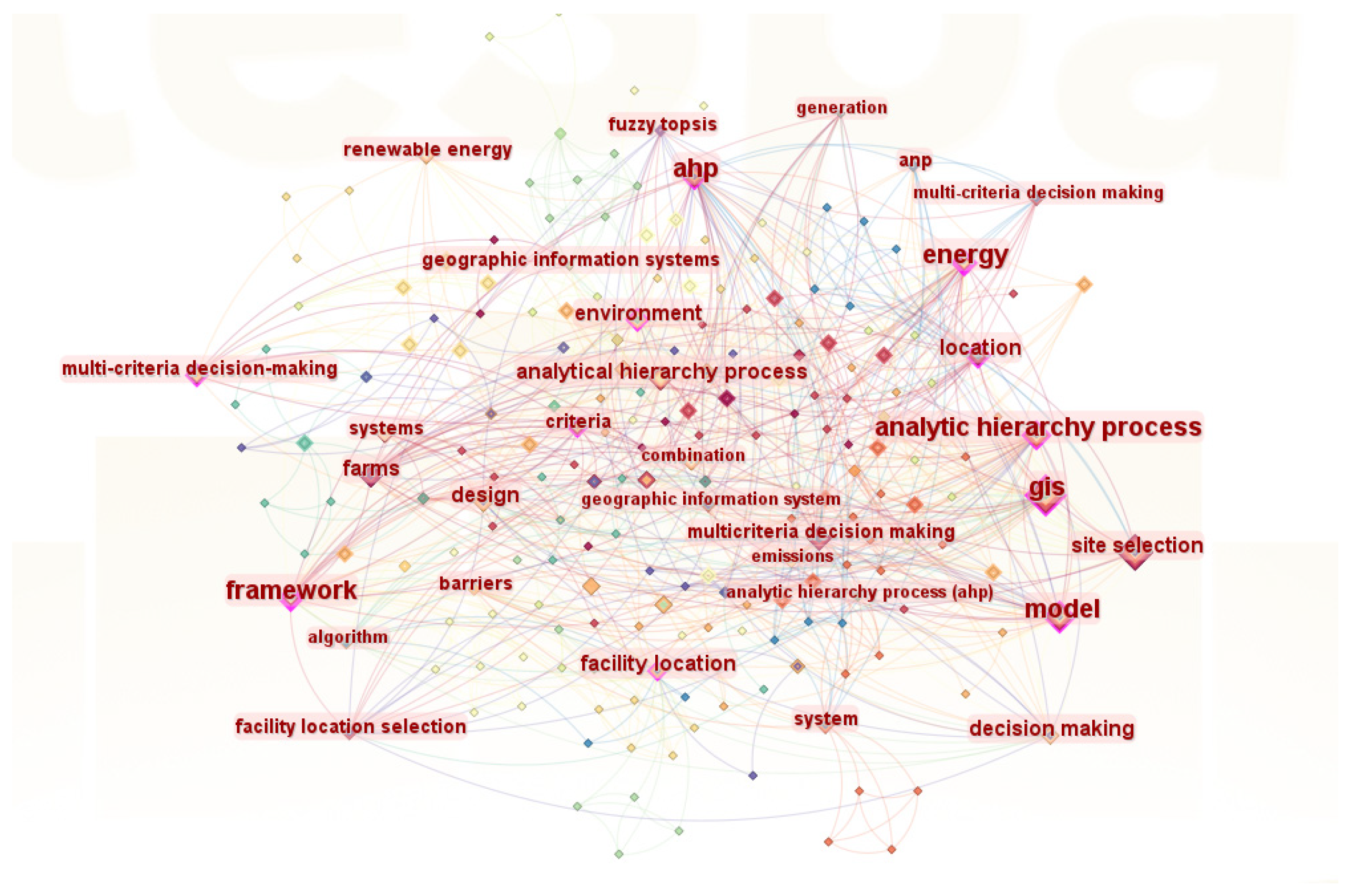
Figure 1. Keyword clustering-based Citespace.
Applsci 15 11379 g001
Figure 2. Timeline analysis-based Citespace.
Applsci 15 11379 g002
Figure 3. MCDM framework in site selection.
Applsci 15 11379 g003
Figure 4. GIS-based topographic and geomorphological analysis.
Applsci 15 11379 g004
Figure 5. Fundamental principles of GNSS positioning.
Applsci 15 11379 g005
Figure 6. Schematic of artificial intelligence-based site selection methods.
Applsci 15 11379 g006
Figure 7. Decision tree (the path marked by the yellow asterisk is the one leading to the optimal result).
Applsci 15 11379 g007
Figure 8. Random Forest (the yellow nodes in each tree highlighting the decision path).
Applsci 15 11379 g008
Figure 9. SVM (the black and white circles denote samples of the two classes, while the red dots lying on the margin boundaries constitute the support vectors).
Applsci 15 11379 g009
Figure 10. ANN structure.
Applsci 15 11379 g010
Figure 11. Attention mechanism.
Applsci 15 11379 g011
Table 1. Site selection criteria.
Primary DimensionSecondary DimensionCore Indicators
Safety FactorsGeological FactorsSlope
Rock and Soil Structure
Land Elevation
Topography and Landforms
Seismic Activity
Distance from Water Sources
Distance from Coastline
Meteorological FactorsHurricanes, Sandstorms, Ice Cover
Average Precipitation
Average Temperature
Average Humidity
Economic FactorsCost FactorsTransmission Line Route and Capacity
Land Cost
Availability of Land for Expansion
Labor Supply
Economic Radius of Transportation
Industrial Electricity Price
Revenue FactorsSolar Irradiance Value
Wind Speed and Direction
Water Depth
Social, Ecological, and Political FactorsSocial FactorsPublic Acceptance and Social Impact
Military Restricted Zones
Radiation Impact
Distance from Residential Areas
Ecological FactorsFarmland, Woodland, Grassland
Nature Reserves
Rare Flora and Fauna Habitats
Bird and Fish Migration Routes
Visual Landscape Impact
Water Bodies
Legal and Policy FactorsLegal Restrictions
Land Ownership
Policy Support
Table 3. Evolutionary directions of operations-research-based industrial site-selection methods.
Evolutionary DirectionsTechnological ApproachesApplication ExamplesOptimization OutcomesSystem ScalabilityTechnological Convergence
AI-Enhanced OptimizationBayesian Optimization [57]Dynamic capacity adjustment of drone stationsService response speed improvedReal-time self-adaptationAI-MCDA integration
Hybrid Multi-Criteria Decision-Making Integrated with GISHybrid Multi-Criteria Decision-Making [56]Solar PV Power Plant Site SelectionEnhanced Suitability in Site SelectionAutomated Site-Selection FrameworkGIS Technology Embedding
Whole-Life-Cycle Management ExtensionDecision Support System (DSS) [53]Integrated bridge design–construction–operation and maintenanceWhole-life-cycle cost reductionMulti-stage closed-loop optimizationCRP-MCDA fusion
Disclaimer/Publisher’s Note: The statements, opinions and data contained in all publications are solely those of the individual author(s) and contributor(s) and not of MDPI and/or the editor(s). MDPI and/or the editor(s) disclaim responsibility for any injury to people or property resulting from any ideas, methods, instructions or products referred to in the content.