Article

Evaluation of Deterioration in Cultural Stone Heritage Using Non-Destructive Testing Techniques: The Case of Emir Ali Tomb (Ahlat, Bitlis, Türkiye)

Department of Civil Engineering, Batman University, Batman 72100, Turkey
Appl. Sci. 2025, 15(19), 10404; https://doi.org/10.3390/app151910404
Submission received: 28 August 2025 / Revised: 22 September 2025 / Accepted: 24 September 2025 / Published: 25 September 2025

Abstract

Stone cultural heritage structures built from pyroclastic rocks are susceptible to deterioration due to their sensitivity to atmospheric processes. Detecting such deterioration and periodically examining it using non-destructive testing (NDT) techniques is one of the most critical measures for ensuring its transmission to future generations. In recent years, assessing the properties of building stones through NDT methods has been widely applied in planning the preservation of stone cultural heritages. In this study, deterioration observed on the interior walls of the Emir Ali Tomb, a structure distinguished from other tombs in the region by its exceptional architecture, was investigated through laboratory tests and NDT techniques, including deep moisture measurement, P-wave velocity, and infrared thermography. It was determined that the monument was constructed from four different types of pyroclastic rock, classified according to their textural and geomechanical characteristics. Using data obtained from in situ tests, NDT distribution maps were generated. The deep moisture, P-wave velocity, and infrared thermography maps revealed that the primary cause of deterioration in the monument was related to capillary water rise.

1. Introduction

Monumental stone structures such as temples, theaters, fortresses, and tombs, built by numerous civilizations from antiquity to the present, constitute an integral part of cultural heritage. Pyroclastic rocks make up the majority of materials used in cultural stone heritage due to their workability, abundance, and esthetic qualities [1]. However, their low mechanical strength increases their susceptibility to atmospheric processes, such as freeze–thaw, wetting–drying, and salt crystallization [2]. Freezing pressure, formed by the freezing of water in the pores of low-strength rocks, or crystalline pressure, caused by the crystallization of salts in the solution, exceeds the strength of the rock and leads to the formation of new cracks in the rock. The cyclicity of these processes significantly increases the speed of deterioration. When rocks used as building materials are directly or indirectly exposed to hydrospheric and atmospheric conditions, they undergo changes, which are defined as deterioration. In general, deterioration refers to a set of physical and mechanical processes in the rock structure, usually progressing slowly under environmental influences, which can cause significant engineering problems [3]. In cultural stone heritage, deterioration processes related to interaction with water may lead to irreversible structural damage. Detecting the damage and assessing its extent in such monuments is one of the primary measures for their preservation. For this purpose, non-destructive tests (NDTs) have recently been increasingly applied by many researchers to detect damage and assess the structural integrity of cultural heritage [4,5,6,7,8,9,10,11,12,13,14,15,16,17,18].
There is a limited number of studies investigating deterioration in monuments built from pyroclastic rocks susceptible to atmospheric processes using NDT methods [10,17,18]. Korkanç et al. [10] investigated the origin of deterioration on the portal of the İnce Minaret, one of the unique examples of Seljuk-period cultural stone heritage, using portable XRF and infrared thermography. Özer et al. [17] in their study, evaluated the changes on the façades of selected structures carved into pyroclastic rocks in the Ancient City of Kilistra using NDT methods (P-wave velocity, Schmidt hammer, and surface moisture meter). Korkanç et al. [18] examined the effect of surface-hardening treatments—contributing to the preservation of the Fraktin rock relief monument, carved by the Hittites—on the physical properties of the rock using both in situ and laboratory NDTs (P-wave velocity, Schmidt hammer, Karsten tube, and surface moisture meter).
The city of Bitlis, with its strategically important location, has been home to various civilizations throughout history, including the Hittite, Assyrian, Urartian, Persian, Seljuk, Byzantine, and Ottoman empires [19,20]. Within its borders, stone cultural heritage structures belonging particularly to the Islamic civilization of the Seljuk and Ottoman periods—such as mosques, cemeteries, tombs, madrasas, and fortresses—are noteworthy. Many monumental tombs, constructed with exceptional stone craftsmanship following the Turks’ adoption of Islam, are also located in Ahlat and are referred to as kümbets. The term kümbet literally means “mound.” The architectural style of the kümbet can be found in every region inhabited by Turks, from East Turkestan to Anatolia. Particularly after the establishment of the Great Seljuk Empire and the conquest of Anatolia, the tomb (kümbet) architecture spread rapidly and can be encountered in many parts of the region [21]. Ahlat is particularly rich in tombs (kümbet). The Ahlat tombs, characterized by cylindrical and polygonal bodies covered by conical or pyramid-shaped covers, were constructed during the Seljuk, Ilkhanid, Qara Qoyunlu, and Aq Qoyunlu periods (Figure 1). The Ahlat tombs were built between the 13th and 15th centuries. In the construction of these tombs, Ahlat stone was preferred as the natural building material.
In this study, the deterioration and interior wall alterations observed in the Emir Ali Tomb (Ahlat–Bitlis, Turkey), a cultural stone heritage monument from the Ilkhanid period (1256–1335) [22], were investigated using NDT methods (P-wave velocity, deep moisture, and infrared thermography). The objective was to characterize the building materials (determining the petrographic and physico-mechanical properties of building stones and their durability against deterioration processes) of this cultural heritage structure and to identify changes associated with deterioration processes, thereby providing a fundamental basis for future restoration projects to ensure its preservation for future generations. The stones on the interior walls of the tomb that were not examined are part of a recent restoration project and were not evaluated as part of this study.

2. Description of the Emir Ali Tomb

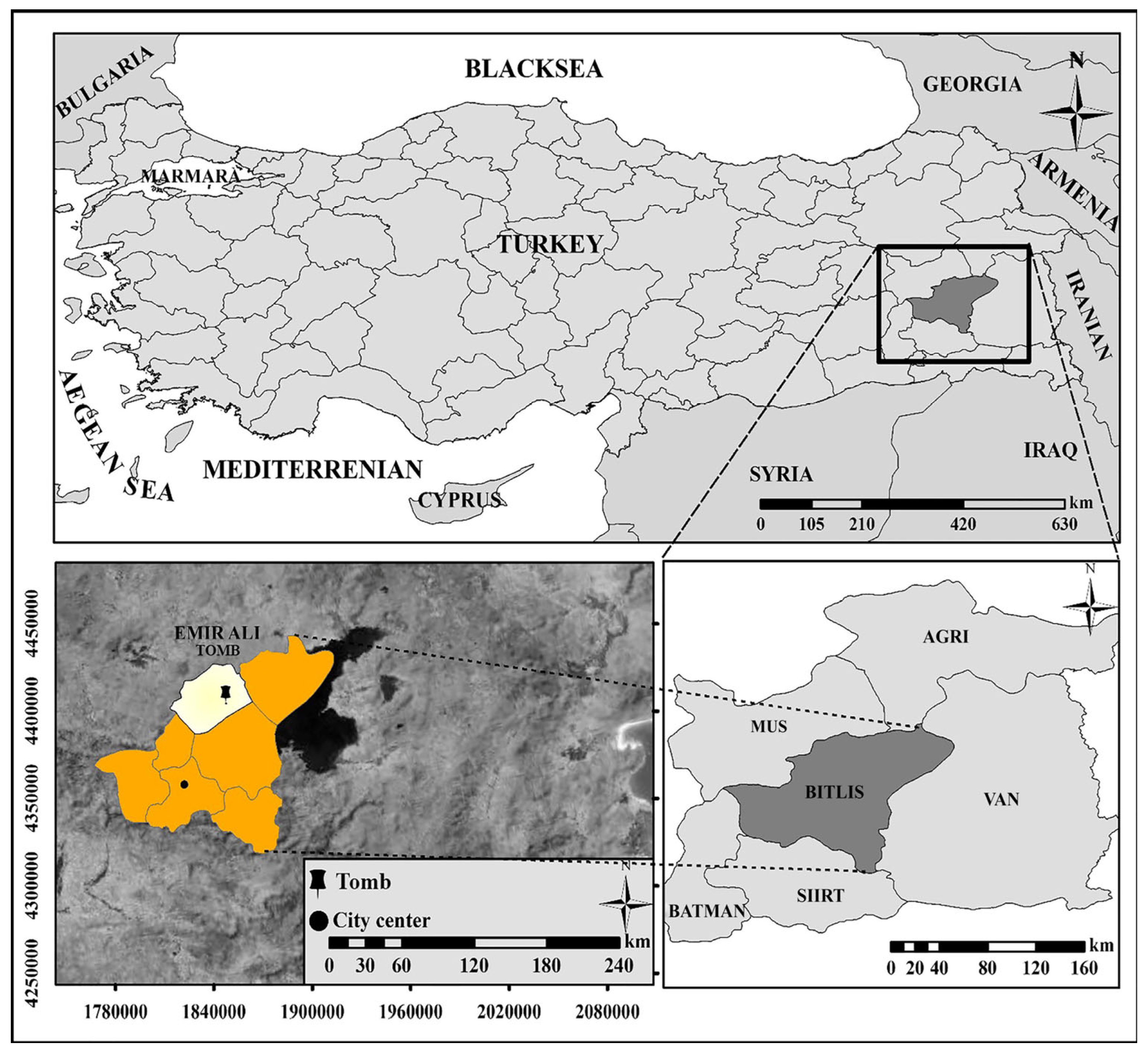
The Emir Ali Tomb, examined within the scope of this study, is located in the district of Ahlat in the province of Bitlis, situated in the Upper Murat–Van section of the Eastern Anatolia Region of Türkiye. The location map of the study area is shown in Figure 2. The district of Ahlat has a harsh continental climate. The winter season, which plays a decisive role in weathering processes, begins early and ends late in this region. Severe winter conditions occur in January, February, and March. Spring is short-lived. July and August are hot and dry. Precipitation generally occurs in winter and spring, predominantly in the form of snow [23]. The meteorological characteristics of Bitlis Province, where the monument is located, are presented in Table 1.
Ignimbrite, a pyroclastic rock type, is characterized by its light weight, ease of workability, and high sound and thermal insulation. For this reason, ignimbrites have been extensively used as building stone material in both historical monuments and contemporary structures in Ahlat and its vicinity, located on the western shore of Lake Van [24]. The ignimbrites quarried from the pyroclastic stone deposits in the region are known as “Ahlat stone”. Some chemical, physical, and mechanical properties of Ahlat stone in different colors, as identified by Özvan et al. [25], are given in Table 2. From a cultural heritage perspective, Ahlat is notable for the Seljuk Cemetery—known as the largest historic monumental cemetery in the Islamic world and included on UNESCO’s World Heritage Tentative List (Figure 3).
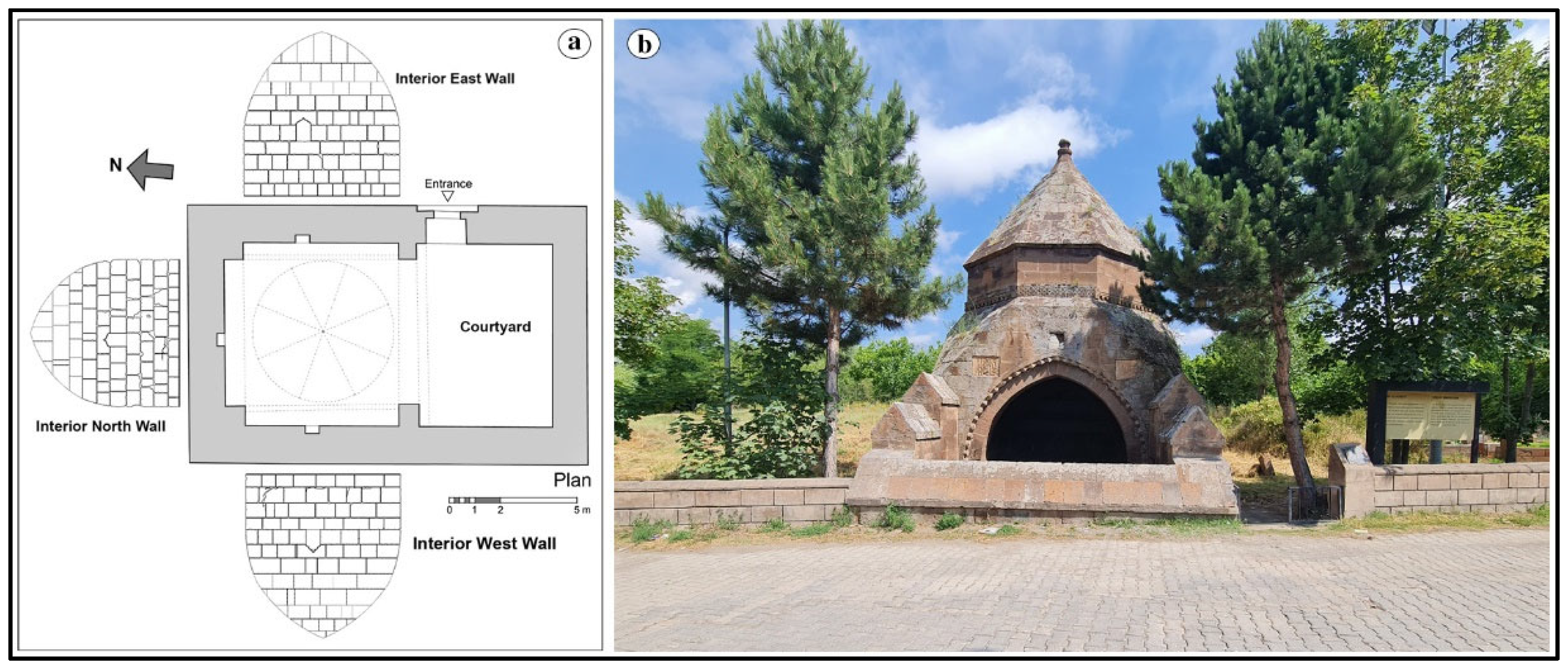
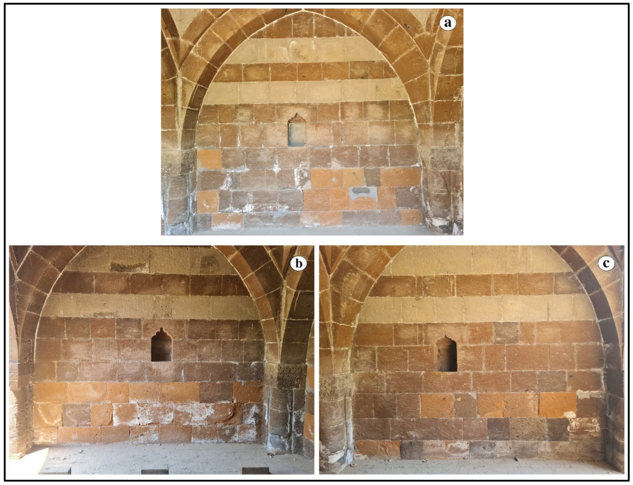
The Emir Ali Tomb was constructed either in the late 13th century or the early 14th century (1306). Among the Ahlat tombs, the Emir Ali Tomb stands out from the others due to its distinctive design and construction. It belongs to the group of tombs with an iwan, and it has a rectangular plan measuring 6.05 m × 5.35 m. As with other tombs, there is no burial chamber (mummy chamber) where the deceased was laid to rest. The tomb is on the same level as the ground [26]. The general and plan views of the Emir Ali Tomb are presented in Figure 4, while the views of its interior walls are shown in Figure 5.

3. Materials and Methods

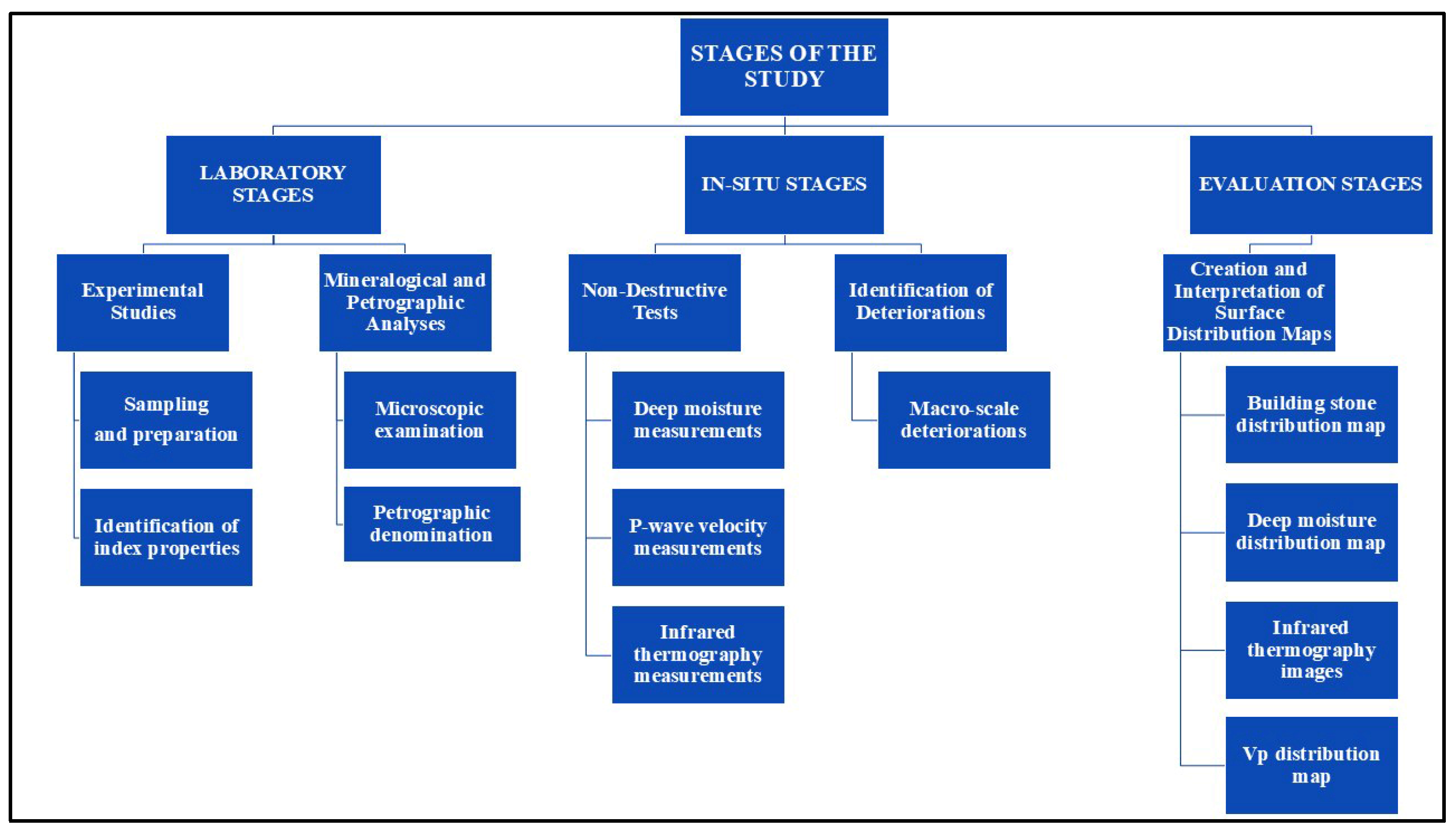
In this study, the investigations conducted to identify the deteriorations observed in the Emir Ali Tomb, located in the district of Ahlat, Bitlis Province, and to evaluate them using NDT techniques were carried out in three distinct stages. The first stage comprised experimental studies and mineralogical–petrographic analyses conducted in the laboratory. The second stage involved in situ NDT and the identification of deteriorations in the building stones used in the monument. The third stage consisted of the evaluation of the data obtained from both laboratory and fieldwork. The study stages are shown in Figure 6.
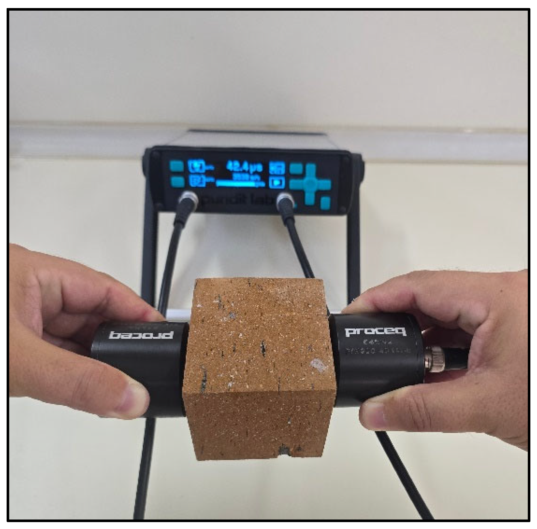
In the laboratory stage, homogeneous block samples representing the rock unit used in the monument and possessing similar textural characteristics were collected from actively operating stone quarries in the region. The macro- and micro-properties of the building stones used in the monument were identified in situ. Based on these properties, the type of building stone was determined. Subsequently, P-wave velocity (Vp) measurements were taken in situ for these types, and their differences were determined; stones similar to them were collected from nearby quarries. The probable location of the ancient quarries from which the stones used in the monument were extracted during its construction is unknown. It is thought that these old quarries have disappeared over time. However, the rocks extracted from quarries actively operating in the region near the monument are quite similar to the monument’s actual building stone in terms of macro properties and NDT characteristics. The physical properties obtained from samples taken from the quarry in operation are provided to better understand the deterioration changes in the monument. For this purpose, for each rock type used in the monument, block samples measuring 30 cm × 30 cm × 25 cm were first obtained from the quarries. Subsequently, from these blocks, five cube samples with an edge length of 7 cm were prepared for each rock type in accordance with the standards specified in TS EN 1936 [27]. These cube samples were used to determine the dry density (ρd), porosity (n), water absorption by weight (Wa), P-wave velocity (Vp), and Schmidt Hammer Rebound (SHR) values of the rocks in the laboratory. The dry density, porosity, and water absorption by weight values were determined according to the methods specified in TS EN 1936 [27]. The P-wave velocity values of the collected samples were measured using a Proceq Pundit Lab Plus tester (Proceq, Schwerzenbach, Switzerland) (Figure 7), following the method recommended in ASTM E494 [28]. This device is equipped with two transducers—a transmitter and a receiver—operating at a frequency of 54 kHz and capable of recording measurements within a range of 0.1 s to 9999 s. The direct measurement method, which involves measuring across flat and smooth opposite surfaces, was employed for the P-wave velocity measurements.
The SHR values of the rocks were determined using an ELE brand L-type hammer (ELE International, Milton Keynes, UK). The Schmidt hammer rebound test was performed in accordance with the standard method recommended in ASTM D5873 [29]. The numerical data selection criteria for the measurements taken from each test sample and the method for determining the specified SHR value of the sample were performed according to the ASTM D5873 [29] standard. As stated in ASTM D5873 [29], firstly, ten measurements were taken from each rock sample to determine the average Schmidt rebound number. Then, rebound values deviating by more than seven units from the average were discarded, and the mean SHR value for the samples was recalculated from the remaining measurements. The mineralogical–petrographic analyses, which formed part of the first stage of the study, involved the microscopic examination of thin sections prepared from the rocks used in the construction of the monument, following the method recommended in TS EN 12407 [30], using a LEICA DM 2700 P (Leica Microsystems GmbH, Wetzlar, Germany) polarizing light microscope.
During the in situ stage of the study, in addition to deep moisture and P-wave velocity measurements of the rocks using NDT techniques, the infrared thermography (IRT) imaging method was also applied (Figure 8). Deep moisture measurements were carried out using a Trotec T610 device (Trotec GmbH & Co. KG, Heinsberg, Germany) (Figure 8a), which operates on the microwave measurement principle and has a maximum penetration depth of 300 mm. The deep moisture measurement method mentioned in this study is not a conventional test method but rather a non-destructive test method that has become widely used in recent years. The measurement unit is expressed as a % (percentage). Measurements were taken three times from the center point of each building block on the walls of the monument, and the average of these measurements was recorded as the deep moisture value for the building block [16,17,18,31]. In situ P-wave velocity measurements of the monument were indirectly determined with a UK 1401 device (Acoustic Control Systems Company, Moscow, Russia), in accordance with the method recommended in ASTM D5873 [29]. This device consists of two integrated probes—a transmitter and a receiver—spaced 20 cm apart and has a measurement capacity of 1500–9990 μs. Measurements on each stone block were repeated at least three times according to the relevant experimental methods, and the average values were recorded [17,18,31] (Figure 8b).
Another NDT measurement conducted in situ was infrared thermography. Thermal images showing the temperature distribution on the surfaces of the Emir Ali Tomb were obtained using a Hikmicro Pocket 2 (Hangzhou Microimage Software Co., Ltd., Hangzhou, China) infrared camera (Figure 8c). This device has a temperature measurement range of −20 °C to 400 °C, with an accuracy of ±2 °C. From the obtained images, the direct effects of solar radiation on the monument and the resulting changes in the stone blocks were evaluated. The identification of the macro-scale deterioration types caused by atmospheric processes on the monument was performed in accordance with the definitions recommended by the International Council on Monuments and Sites–International Scientific Committee for Stone (ICOMOS–ISCS) [32].
In the third stage of the study, which involved data evaluation, the distribution of deep moisture and P-wave velocity measurements obtained in situ through NDT was processed using Surfer 22.3.185 [33]. These distributions were overlaid onto the plan drawing of the monument to create surface deterioration maps corresponding to the NDT methods assessed within the scope of the study.
Moreover, statistical relationships between some of the NDT results were also investigated within the scope of this study. In this context, a simple regression analysis was performed between the Vp values measured in the field and the DM values, and the linear model was estimated as follows:
V p i = β 0 + β 1 D M i + ϵ i
where V p i and D M i   represent the difference between the in situ P-wave velocity and the DM, which is the deep moisture measurement from each stone i respectively; β 0 is the constant term of the linear regression; β 1 measures the sensitivity of Vp to changes in DM; and ϵ i is the error term of the regression. The equation is estimated in Stata/IC 15.1 [34] using the built-in regress command. The number of observations is 176. Huber–White robust standard errors are calculated. F (1, 174) = 8.18 with a p-value of 0.0048, indicating that overall the model is statistically significant at α = 0.01 .

4. Results and Discussion

4.1. Petrographic and Physical Properties of Rocks

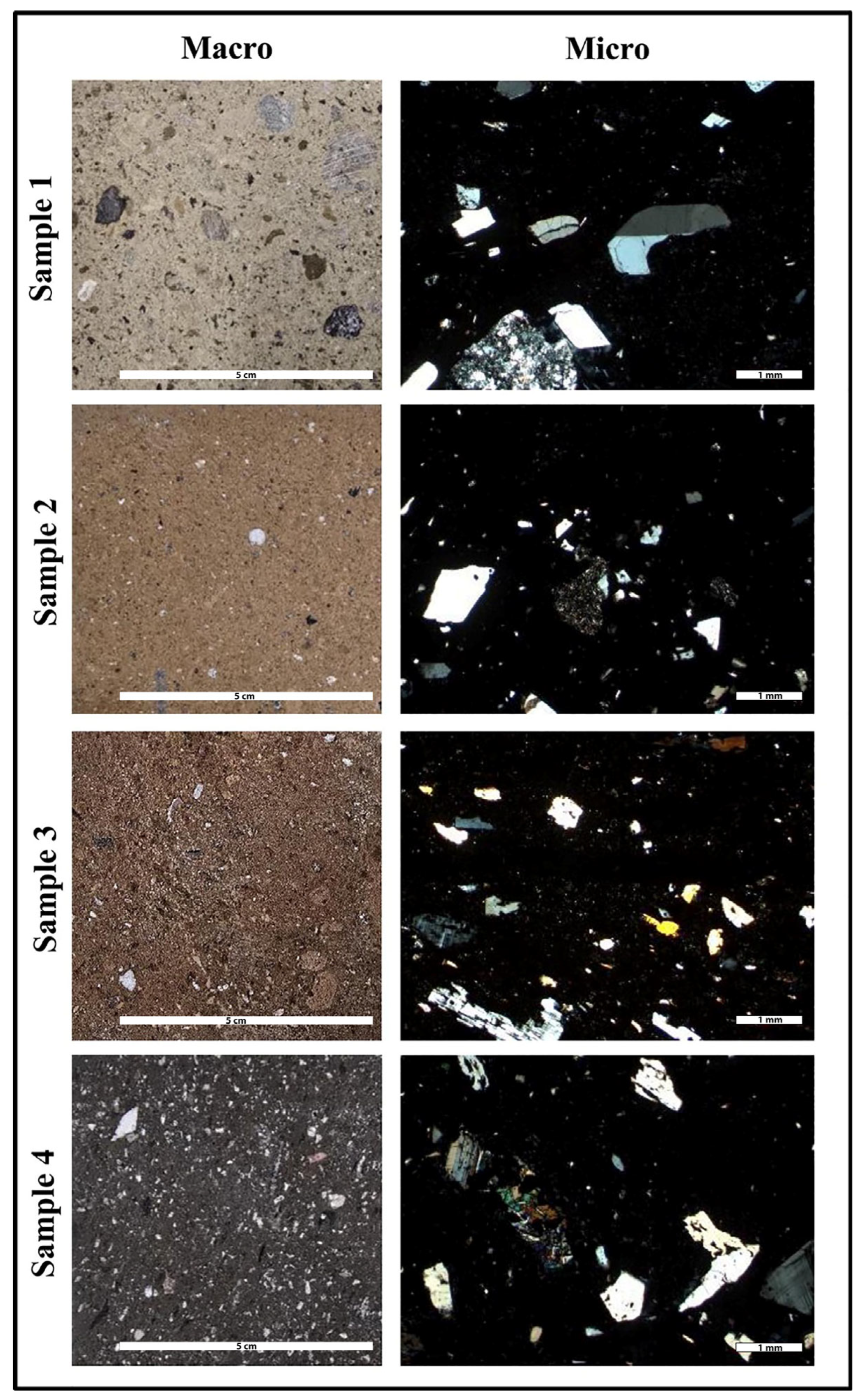
Considering the macro-, micro-, and geomechanical characteristics of the Ahlat stones used in the construction of the Emir Ali Tomb, it has been determined that they consist of four different rock types. The macro- and textural properties of these building stones are presented in Table 3. Although the mineralogical compositions of these rocks are similar, differences exist in their color and macro-texture (Figure 9). A fiamme texture is observed in all samples, and the rock is classified as “ignimbrite.”
The geomechanical properties of the Ahlat stones used in the monument (dry density, porosity, water absorption by weight, P-wave velocity, and Schmidt hammer rebound) are given in Table 4. According to the NBG [35] dry density classification, all samples fall into the low-density rock category; however, according to the NBG [35] porosity classification, they belong to the very high rock category.
The types of deterioration observed in the Emir Ali Tomb were named according to the definitions recommended by ICOMOS-ISCS [32]. Differential erosion, contour scaling, cracks, black crust, efflorescence, graffiti, and biological colonization (lichen, moss, and higher plants) were observed in various parts of the monument (Figure 10). Cracks observed in the monument have developed over time as a result of structural problems (Figure 10a). Scaling deterioration, ranging from millimeters to centimeters in the building stone blocks and related to atmospheric processes, is defined as contour scaling (Figure 10b). Due to the difference in elevation in the area where the monument is located, efflorescence has developed extensively in the interior walls situated below the topography (Figure 10c). Efflorescence appears on the surfaces of the building stones as whitish, granular deposits, generally with weak cohesion. Black crust formations were detected on the exterior surfaces of the building stones (Figure 10d). As a result of compositional differences in the building stones, differential erosion was identified (Figure 10e,f). On the exterior surfaces of the monument, algae, lichens, mosses, and higher plants were observed (Figure 10g). In addition, graffiti-type deteriorations were found in various parts of the monument’s exterior surface due to anthropogenic effects (Figure 10h).

4.2. NDT Results

Three different NDT measurements were performed in situ as part of the study. The IRT device used in this study cannot display IRT data for each stone simultaneously. It provides an IRT image for general viewing in one shot. However, the other NDT data, namely DM and Vp values, are marked on the stones accordingly (Figure 11).
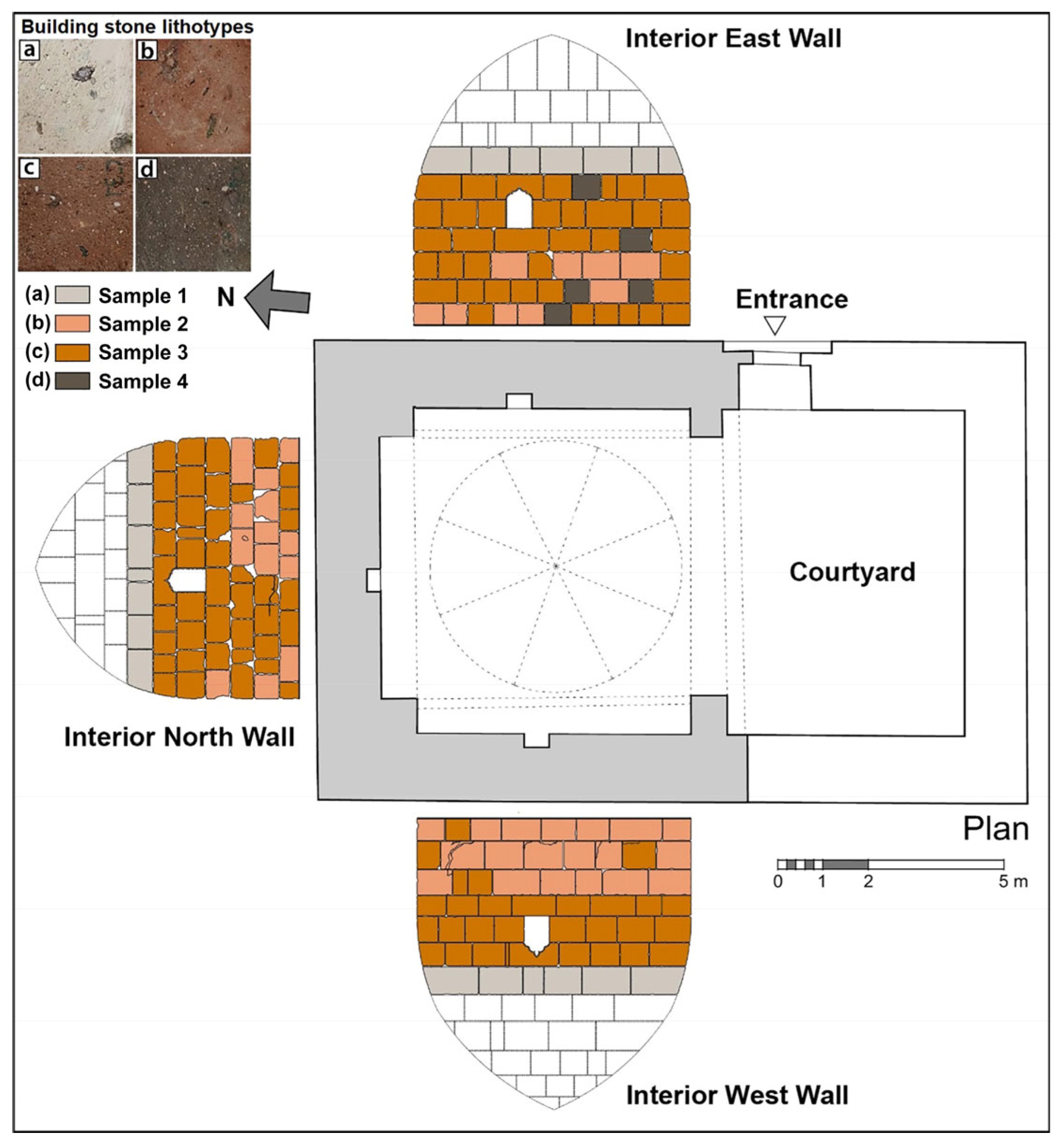
Different Ahlat stones were used in the construction of the Emir Ali Tomb. Their distribution within the interior walls of the monument is shown in Figure 12. Figure 12 enables the NDT maps to be more understandable and interpretable. The deep moisture (DM) and P-wave velocity (Vp) variation maps obtained from the NDT data of the tomb, along with the infrared thermography (IRT) images, are explained in the following subsections.

4.2.1. Deep Moisture Measurements

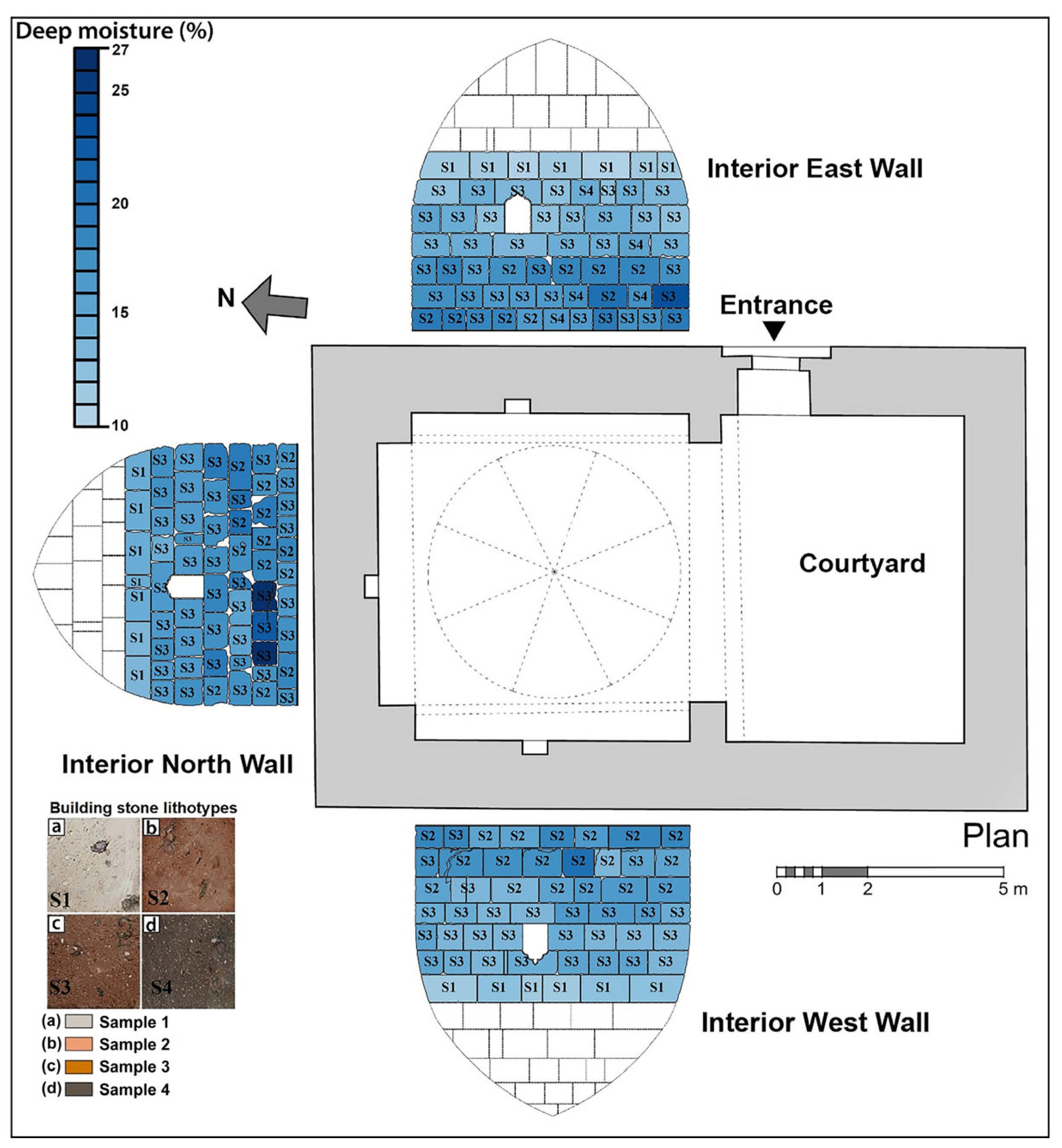
The susceptibility of weak pyroclastic rocks to atmospheric processes increases as their degree of saturation rises [36]. In the deterioration process of cultural stone heritage, one of the most important agents is water. Determining the presence of water and its distribution across the walls of monuments is the first step in planning restoration processes [17]. For this purpose, the moisture distribution on the interior walls of the Emir Ali Tomb was determined for each building stone using a deep moisture meter, and deep moisture (DM) variation maps were prepared (Figure 13).
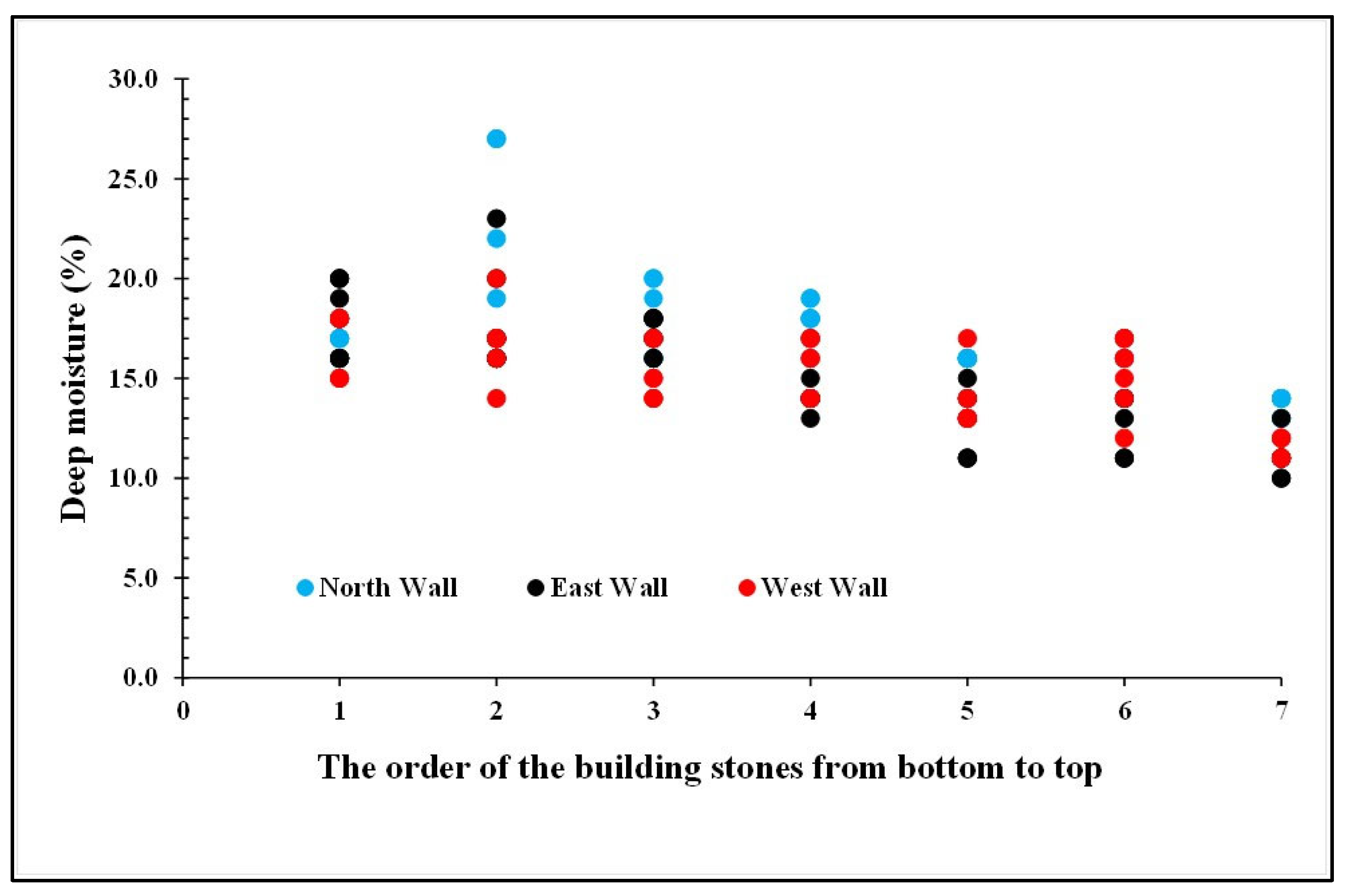
The DM values in the interior walls of the monument were found to range between 10% and 27%. The highest values are generally observed at the base elevations of the monument. These values decrease toward the upper elevations of the monument in direct proportion to the capillary rise in groundwater. Depending on the properties of the different Ahlat stones used in the construction, different DM values were observed at the same elevation. The capillarity effect has caused water to rise on all sides of the monument. This effect has directly influenced the DM value within each building stone. This relationship is shown in Figure 14. The base level of the monument walls was taken as the reference level. The stones on the monument walls were assigned a sequence number starting from the reference level (base) and moving upward. As the distance of the stones on the walls from the base level increased, the capillary effect reduced, and the DM values also decreased.

4.2.2. Infrared Thermography Measurement

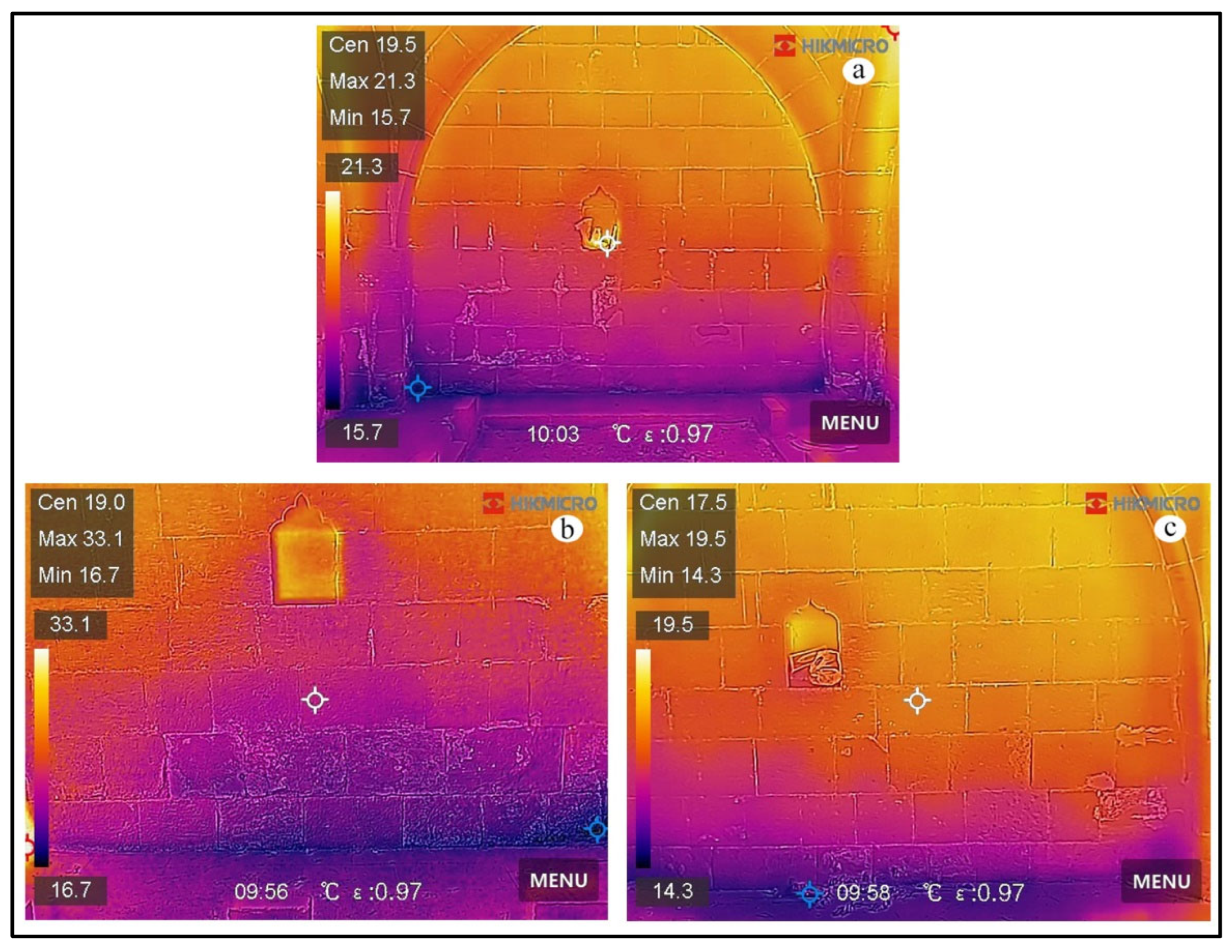
Infrared thermography (IRT) is a method based on detecting and visualizing the infrared (IR) radiation emitted by an object. Recently, this NDT method has been widely preferred in the investigation of historic structures due to its rapid applicability and cost-effectiveness. Thermal images of the monument’s interior walls are shown in Figure 15. The temperature values of the northern interior wall range from 15.7 °C to 21.3 °C (Figure 15a). In the thermal image of the western interior wall, the temperature variation ranges from 16.7 °C to 33.1 °C (Figure 15b). The eastern interior wall temperatures range between 14.3 °C and 19.5 °C (Figure 15c).
An examination of the thermal images of all interior walls shows that the temperature distribution data are consistent with the exterior topographic elevation and the capillary water rise zone. As the capillary rise increases, moisture decreases, leading to an increase in temperature values. This observation is also consistent with the DM maps.

4.2.3. P-Wave Velocity Measurements

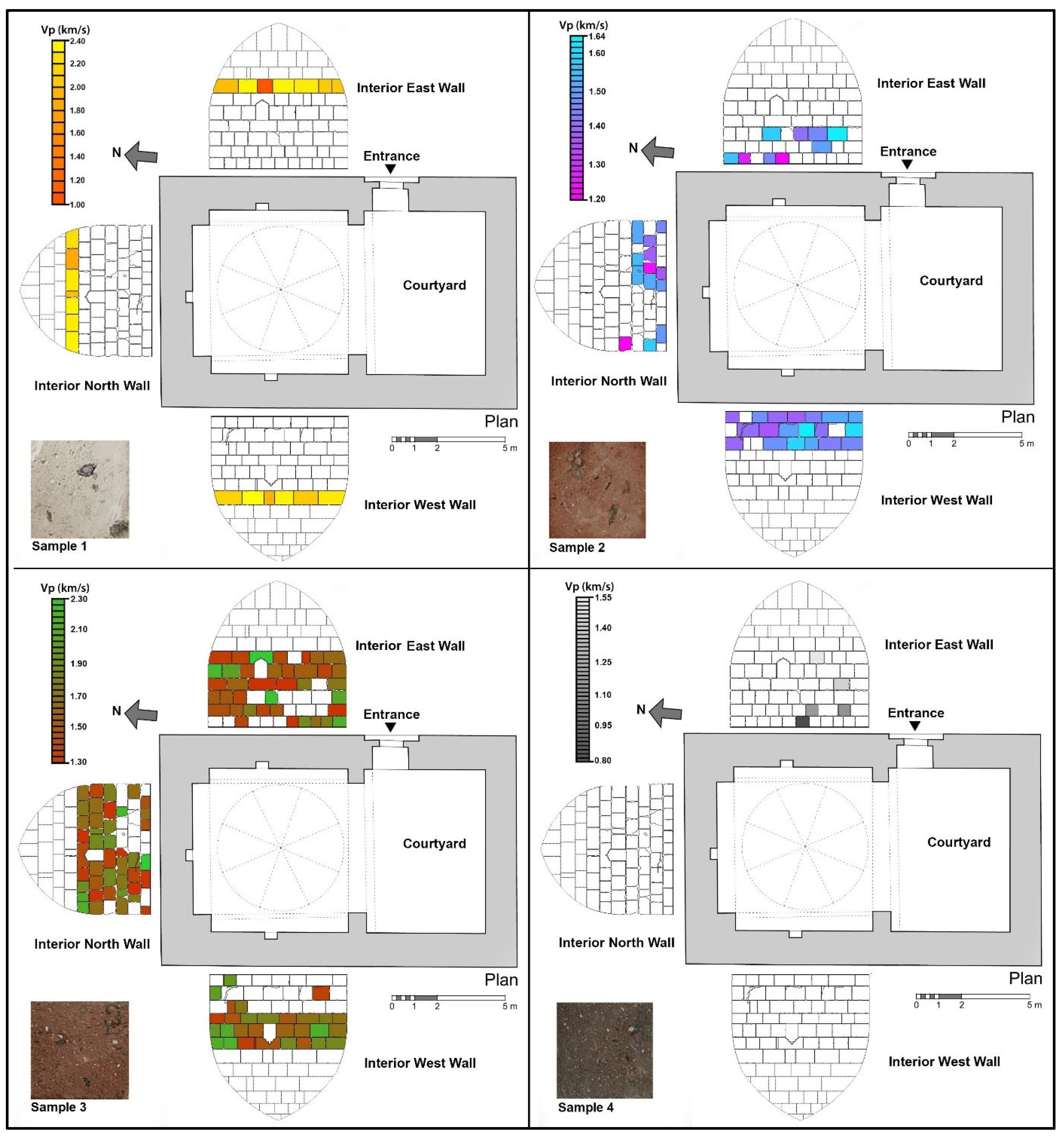
P-wave velocity is one of the most commonly used NDTs for determining the strength, porosity, and deterioration characteristics of rocks [37]. In the Emir Ali Tomb, Vp varies according to the different building stones, and these variations are shown in Figure 16. Examination of Figure 16 reveals that the most important factors affecting P-wave velocity variations are the geomechanical properties of the rocks, the location of the building stones, and their dimensions. The greatest changes compared to the initial Vp values are observed in the building stones located in the capillary rise zone.
The primary reason for this is the damage caused by the recrystallization of salts dissolved in water that enters the rock during summer months as temperatures rise (Figure 17). In this process, the intensity of solar radiation is one of the main factors directly determining the type and degree of deterioration observed in the building stones of the monument [38]. When data on the building stone properties (geomechanical properties, location, and size) and the solar radiation to which they are exposed are evaluated together, the wide range of Vp variations in the interior walls of the monument can be explained. Furthermore, the diversity of components forming the rocks [39,40] and differences in measurement techniques [41] should not be overlooked, as they may also influence these values.
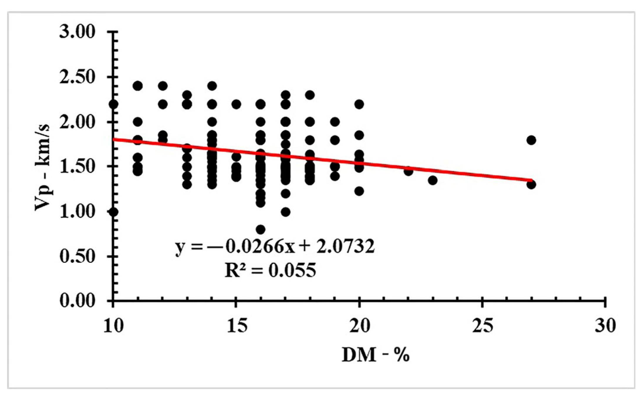
Statistical relationships between non-destructive test results obtained from in situ tests were also examined. For this purpose, data obtained from P-wave tests were compared with deep moisture measurement data (Figure 18). In particular, the following linear model was estimated:
V p i = β 0 + β 1 D M i + ϵ i
The estimated value of β 1 is −0.02666 (Figure 18). The t-value is −2.86 and the p-value is reported as 0.005, using Huber—White robust standard errors. This rejects the null hypothesis that β 1 = 0 at α = 0.01 statistical significance and implies that increasing DM is negatively and significantly associated with lower Vp. However, as reflected in the R-squared of 0.055, deep moisture can explain only a small part of the variation in Vp. This situation is due to the fact that water content is a related but not primary parameter directly affecting the P-wave velocity of rocks, as previously emphasized by other researchers [42,43].
In previous investigations, the relationship between P-wave velocity and the number of cycles for rapid deterioration test results was statistically evaluated. It was observed that the graphs explained the changes in the rocks with high correlation [44,45]. The success of the NDT methods presented in this study in detecting deteriorations was also assessed. Figure 19 shows that the deterioration in the rocks within the red areas, where the lowest P-wave velocity values are observed, is quite obvious and visible. P-wave velocity values provide information about changes in the internal structure of the rock, in addition to visible deterioration. Among NDTs, measuring P-wave velocity test is one of the most effective methods for determining deterioration-related changes.

5. Conclusions

The findings obtained from laboratory and in situ investigations of the Emir Ali Tomb, a stone cultural heritage from the Ilkhanate period, can be summarized as follows:
  • The building material of the monument is Ahlat stone, widely used in the region, and four different rock types were identified based on their color and geomechanical properties.
  • On the interior and exterior surfaces of the monument, deterioration types such as differential erosion, contour scaling, cracks, black crust, efflorescence, graffiti, lichens, moss, and higher plants were identified. The most prominent type of deterioration is efflorescence, which is widespread in the capillary zone of the monument.
  • Deep moisture distributions in the interior walls range from 10% to 27%, with the capillary zone being the most significant factor controlling this distribution.
  • In infrared thermography images, the lowest temperature was measured on the east interior wall (14.3 °C), and the highest on the west interior wall (33.1 °C). This temperature variation is related to the monument’s exterior topographic elevation and capillary water rise.
  • P-wave velocity values vary widely depending on the atmospheric processes to which the monument is exposed. The geomechanical properties (water absorption value by weight, porosity, P-wave velocity, etc.), location (geographical direction, height from the base, duration of sunlight exposure, etc.), and size of the building stones are important factors in this variation.
For the preservation of cultural stone heritage structures built with weak pyroclastic rocks for future generations, the most critical factor is controlling the ingress of water into the monument. The most effective methods for determining this, without causing damage to the monument, are NDTs such as deep moisture measurement and infrared thermography. Additionally, the most effective method for detecting changes in the monument’s building stones due to deterioration is to measure the P-wave velocity, which also provides information about changes in the internal structure of the material. This study demonstrates that the non-destructive testing (NDT) methods described herein can provide useful information about the external and internal structure of building stones for conservators, architects, and engineers, thereby ensuring the passing on of cultural stone heritage for future generations.

Funding

This research received no external funding.

Institutional Review Board Statement

Not applicable.

Informed Consent Statement

Not applicable.

Data Availability Statement

The original contributions presented in the study are included in the article, further inquiries can be directed to the corresponding author.

Acknowledgments

I would like to express my appreciation to the Republic of Türkiye Ministry of Culture and Tourism, Directorate General of Foundations, Bitlis Regional Directorate of Foundations, for the necessary permissions provided for this work.

Conflicts of Interest

The author declares no conflicts of interest.

References

  1. Bozdağ, A.; Bayram, A.F.; İnce, İ.; Asan, K. The relationship between weathering and welding degree of pyroclastic rocks in the Kilistra ancient city, Konya (Central Anatolia, Turkey). J. Afr. Earth Sci. 2016, 123, 1–9. [Google Scholar] [CrossRef]
  2. İnce, İ.; Bozdağ, A.; Korkanç, M. Leeb Hardness Approach in the Determination of Strength after Accelerated Weathering Tests. Stud. Conserv. 2025, 70, 332–342. [Google Scholar] [CrossRef]
  3. Tuğrul, A. Niksar Yöresindeki Bazaltların Mühendislik Özelliklerine Ayrışmanın Etkileri. Ph.D. Thesis, İstanbul Üniversitesi, Fen Bilimleri Enstitüsü, İstanbul, Turkey, 1995. [Google Scholar]
  4. Mol, L.; Preston, P.R. The writing’s in the wall: A review of new preliminary applications of electrical resistivity tomography within archaeology. Archaeometry 2010, 52, 1079–1095. [Google Scholar] [CrossRef]
  5. Fort, R.; de Buergo, M.A.; Perez-Monserrat, E.M. Non-destructive testing for the assessment of granite decay in heritage structures compared to quarry stone. Int. J. Rock Mech. Min. Sci. 2013, 61, 296–305. [Google Scholar] [CrossRef]
  6. Jo, Y.H.; Lee, C.H. Quantitative modeling and mapping of blistering zone of the Magoksa Temple stone pagoda (13th century, Republic of Korea) by graduated heating thermography. Infrared Phys. Technol. 2014, 65, 43–50. [Google Scholar] [CrossRef]
  7. Kilic, G. Using advanced NDT for historic buildings: Towards an integrated multidisciplinary health assessment strategy. J. Cult. Herit. 2015, 16, 526–535. [Google Scholar] [CrossRef]
  8. Fais, S.; Cuccuru, F.; Ligas, P.; Casula, G.; Bianchi, M.G. Integrated ultrasonic, laser scanning and petrographical characterisation of carbonate building materials on an architectural structure of a historic building. Bull. Eng. Geol. Environ. 2017, 76, 71–84. [Google Scholar] [CrossRef]
  9. İnce, İ.; Bozdağ, A.; Tosunlar, M.B.; Hatır, M.E.; Korkanç, M. Determination of deterioration of the main facade of the Ferit Paşa Cistern by non-destructive techniques (Konya, Turkey). Environ. Earth Sci. 2018, 77, 420. [Google Scholar] [CrossRef]
  10. Korkanç, M.; Hüseyinca, M.Y.; Hatır, M.E.; Tosunlar, M.B.; Bozdağ, A.; Özen, L.; İnce, İ. Interpreting sulfated crusts on natural building stones using sulfur contour maps and infrared thermography. Environ. Earth Sci. 2019, 78, 378. [Google Scholar] [CrossRef]
  11. Valero, L.R.; Sasso, V.F.; Vicioso, E.P. In situ assessment of superficial moisture condition in façades of historic building using non-destructive techniques. Case Stud. Constr. Mater. 2019, 10, e00228. [Google Scholar] [CrossRef]
  12. Bozdağ, A.; İnce, İ.; Bozdağ, A.; Hatır, M.E.; Tosunlar, M.B.; Korkanç, M. An assessment of deterioration in cultural heritage: The unique case of Eflatunpınar Hittite Water Monument in Konya, Turkey. Bull. Eng. Geol. Environ. 2020, 79, 1185–1197. [Google Scholar] [CrossRef]
  13. Tosunlar, M.B.; Beycan, A.D.O.; Korkanç, M. Non-destructive test investigations on the deterioration of roman mausoleum in Karadağ central anatolia, Turkey. Mediterr. Archaeol. Archaeom. 2020, 20, 199. [Google Scholar] [CrossRef]
  14. Wu, Y.; Li, Q.; Tong, H.; He, Z.; Qu, J.; Zhang, B. Monitoring the deterioration of masonry relics at a UNESCO World Heritage site. KSCE J. Civ. Eng. 2021, 25, 3097–3106. [Google Scholar] [CrossRef]
  15. Hatir, M.E.; Barstuğan, M.; İnce, İ. Deep learning-based weathering type recognition in historical stone monuments. J. Cult. Herit. 2020, 45, 193–203. [Google Scholar] [CrossRef]
  16. Hatır, M.E.; Ince, I.; Bozkurt, F. Investigation of the effect of microclimatic environment in historical buildings via infrared thermography. J. Build. Eng. 2022, 57, 104916. [Google Scholar] [CrossRef]
  17. Özer, F.; Söylemez, M.; İnce, İ.; Günaydin, O. Detection of deteriorations in cultural structures created by carving into low-strength rocks by the non-destructive test (NDT) method. Front. Archit. Res. 2023, 12, 788–802. [Google Scholar] [CrossRef]
  18. Korkanç, M.; İnce, İ.; Hüseyinca, M.Y.; Tosunlar, M.B.; Hatır, M.E. The effect of case hardening on the natural preservation of stone monuments, Fraktin monument, Türkiye. Bull. Eng. Geol. Environ. 2025, 84, 258. [Google Scholar] [CrossRef]
  19. Yılmaz, V. İç göçün nedenleri ve değerlendirilmesi: Bitlis ili örneği. OPUS Int. J. Soc. Res. 2019, 11, 1709–1735. [Google Scholar] [CrossRef]
  20. Güleryüz, U. Bitlis in İnanç Turizmi Potansiyeli Üzerinde Ohin Norşin ve Hizan Medreselerinin Etkileri. In Proceedings of the 6th Uluslararası Marmara Bilimsel Araştırmalar ve İnovasyon Kongresi, İstanbul, Turkey, 7–8 October 2023. [Google Scholar]
  21. Bektaşoğlu, M. Anadolu’da Türk İslam Sanatı; Diyanet İşleri Başkanlığı: Ankara, Turkey, 2009. [Google Scholar]
  22. Biran, M. Il-Khanate Empire. In The Encyclopedia of Empire; John, M.M., Ed.; John Wiley & Sons, Ltd.: Chichester, UK, 2016. [Google Scholar] [CrossRef]
  23. Available online: https://www.mgm.gov.tr/veridegerlendirme/il-ve-ilceler-istatistik.aspx?k=undefined&m=BITLIS (accessed on 29 July 2025).
  24. Akın, M.; Dinçer, İ.; Özvan, A.; Oyan, V.; Tapan, M. İgnimbiritlerdeki kılcal su emme özelliğinin Ahlat Selçuklu mezar taşlarının bozunmasındaki rolü. Jeol. Mühendisliği Derg. 2016, 40, 149–166. [Google Scholar] [CrossRef]
  25. Özvan, A.; Dinçer, İ.; Akın, M.; Oyan, V.; Tapan, M. Experimental studies on ignimbrite and the effect of lichens and capillarity on the deterioration of Seljuk Gravestones. Eng. Geol. 2015, 185, 81–95. [Google Scholar] [CrossRef]
  26. Ötüken, S.Y. Türkiyeʼde Vakıf Abideler ve Eski Eserler: Balıkesir. Bilecik. Bingöl. Bitlis. Bolu. Burdur; Vakıflar Genel Müdürlüğü: Kizilay, Turkey, 1977; Volume 2. [Google Scholar]
  27. TS EN-1936: 2010; Natural Stone Test Methods—Determination of Real Density and Apparent Density and of Total and Open Porosity. Turkish Standards Institution: Ankara, Turkey, 2010.
  28. ASTM E494; Standard Practice for Measuring Ultrasonic Velocity in Materials. ASTM International: West Conshohocken, PA, USA, 2010.
  29. ASTM D5873; Standard Test Method for Determination of Rock Hardness by Rebound Hammer Method. ASTM International: West Conshohocken, PA, USA, 2014.
  30. TS EN-12407; Natural Stone Test Methods—Petrographic Examination. Turkish Standards Institution: Ankara, Turkey, 2019.
  31. İnce, İ.; Korkanç, M.; Hatır, M.E. Evaluation of weathering effects due to surface and deep moisture in a Roman rock tomb: Lukianos Monument Konya (Turkey). Mediterr. Archaeol. Archaeom. 2020, 20, 121. [Google Scholar] [CrossRef]
  32. International Council on Monument and Sites International Scientific Committee for Stone (ICOMOS-ISCS). Illustrated Glossary on Stone Deterioration Patterns; Ateliers 30 Impresión; International Council on Monument and Sites International Scientific Committee for Stone: Champigny-sur-Marne, France, 2008. [Google Scholar]
  33. Golden Software. Environmental Services: Accurately Assess Your Site and Confidently Advise Stakeholders; Golden Software, LLC.: Golden, CO, USA, 2025; Available online: https://www.goldensoftware.com (accessed on 23 August 2025).
  34. StataCorp. Stata Statistical Software: Release 15; StataCorp LLC.: College Station, TX, USA, 2017. [Google Scholar]
  35. NBG. Engineering Geology and Rock Engineering; Norwegian Group of Rock Mechanics: Fornebu, Norway, 1985. [Google Scholar]
  36. Chen, T.C.; Yeung, M.R.; Mori, N. Effect of water saturation on deterioration of welded tuff due to freeze-thaw action. Cold Reg. Sci. Technol. 2004, 38, 127–136. [Google Scholar] [CrossRef]
  37. Korkanç, M.; İnce, İ.; Hatır, M.E.; Tosunlar, M.B. Atmospheric and anthropogenic deterioration of the İvriz rock monument: Ereğli-Konya, Central Anatolia, Turkey. Bull. Eng. Geol. Environ. 2021, 80, 3053–3063. [Google Scholar] [CrossRef]
  38. Hatır, M.E.; İnce, İ.; Korkanç, M. The effect of wind and solar radiation on deterioration developments in historic buildings: Şeyh Osman Rumi Tomb, Central Turkey. Environ. Earth Sci. 2024, 83, 617. [Google Scholar] [CrossRef]
  39. Fener, M. The effect of rock sample dimension on the P-wave velocity. J. Nondestruct. Eval. 2011, 30, 99–105. [Google Scholar] [CrossRef]
  40. Liao, Z.; Xu, J.; Zhang, K.; Zhou, C. Exploring wave propagation behaviors in rock: A grain-based perspective on mineral structures. Deep Undergr. Sci. Eng. 2025, 1–15. [Google Scholar] [CrossRef]
  41. İnce, İ.; Karakaya, E.; Balci, M.C.; Tosunlar, M.B. Investigation of the relationships between direct and semi-direct P-wave velocity measurement techniques in igneous rocks. Sādhanā 2025, 50, 145. [Google Scholar] [CrossRef]
  42. Karakul, H.; Ulusay, R. Empirical correlations for predicting strength properties of rocks from P-wave velocity under different degrees of saturation. Rock Mech. Rock Eng. 2013, 46, 981–999. [Google Scholar] [CrossRef]
  43. Kahraman, S.; Fener, M.; Kilic, C.O. Estimating the wet-rock P-wave velocity from the dry-rock P-wave velocity for pyroclastic rocks. Pure Appl. Geophys. 2017, 174, 2621–2629. [Google Scholar] [CrossRef]
  44. Fener, M.; Ince, I. Effects of the freeze–thaw (F–T) cycle on the andesitic rocks (Sille-Konya/Turkey) used in construction building. J. Afr. Earth Sci. 2015, 109, 96–106. [Google Scholar] [CrossRef]
  45. Gökçe, M.V.; İnce, İ.; Fener, M.; Taşkıran, T.; Kayabali, K. The effects of freeze–thaw (F–T) cycles on the Gödene travertine used in historical structures in Konya (Turkey). Cold Reg. Sci. Technol. 2016, 127, 65–75. [Google Scholar] [CrossRef]
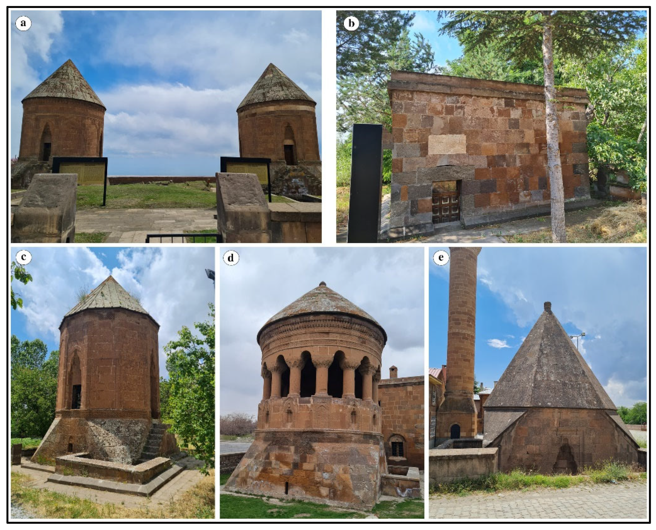
Figure 1. Some examples of Ahlat tombs: (a) Double tomb, (b) Dede Maksut tomb, (c) Kesis tomb, (d) Emir Bayındır tomb, (e) Mirza Muhammed tomb.
Applsci 15 10404 g001
Figure 2. Location map of Emir Ali Tomb.
Applsci 15 10404 g002
Figure 3. Seljuk cemetery in Ahlat.
Applsci 15 10404 g003
Figure 4. Emir Ali Tomb: (a) plan view, (b) general view.
Applsci 15 10404 g004
Figure 5. Interior walls of Emir Ali Tomb: (a) north wall, (b) west wall, (c) east wall.
Applsci 15 10404 g005
Figure 6. Workflow diagram for the stages of the study.
Applsci 15 10404 g006
Figure 7. Measurement of P-wave velocity in the laboratory.
Applsci 15 10404 g007
Figure 8. NDT techniques applied to the tomb: (a) deep moisture measurement, (b) P-wave measurement, (c) thermal measurements.
Applsci 15 10404 g008
Figure 9. Macro-and micro-appearance of the Ahlat stones used in the tomb.
Applsci 15 10404 g009
Figure 10. Deteriorations observed in the Emir Ali Tomb: (a) crack, (b) contour scaling, (c) efflorescence, (d) black crust, (e,f) differential erosion, (g) biological colonization (lichen, moss, and higher plants), (h) graffiti.
Applsci 15 10404 g010
Figure 11. Numerical representation of DM and Vp data on the monument’s walls.
Applsci 15 10404 g011
Figure 12. Distribution of building stones on the interior walls of the tomb.
Applsci 15 10404 g012
Figure 13. Deep moisture distribution map of the monument’s interior walls.
Applsci 15 10404 g013
Figure 14. The relationship between DM values and elevation.
Applsci 15 10404 g014
Figure 15. Thermal images of the tomb’s interior walls: (a) north wall, (b) west wall, (c) east wall.
Applsci 15 10404 g015
Figure 16. Vp distribution maps of building stones in the interior walls.
Applsci 15 10404 g016
Figure 17. Variations in deterioration according to the geomechanical properties, location, and dimensions of different building stones.
Applsci 15 10404 g017
Figure 18. Comparison of the statistical relationship between P-wave velocity (Vp) and deep moisture (DM) measurements.
Applsci 15 10404 g018
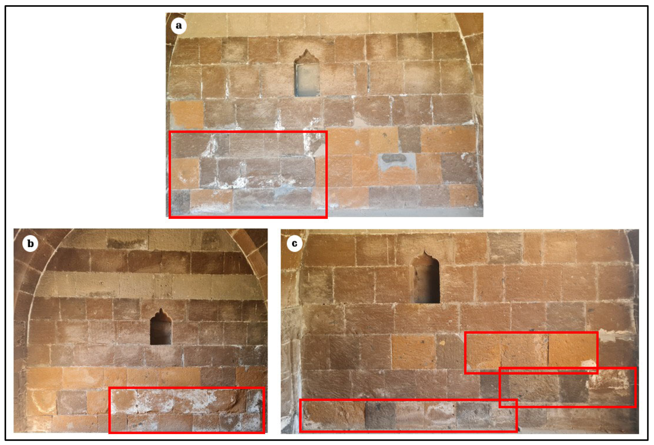
Figure 19. The most visible deterioration areas on the monument interior walls: (a) north wall, (b) west wall, (c) east wall.
Applsci 15 10404 g019
Table 1. Meteorological data for Bitlis [23].
Measurement Period (2011–2024)
MonthsAverage Temperature (°C)Average Maximum Temperature (°C)Average Minimum Temperature (°C)Monthly Average Total Precipitation (mm)Maximum Temperature (°C)Minimum Temperature (°C)
January−4.2−0.4−7.9157.010.1−24.1
February−3.21.1−7.1110.221.9−21.3
March 0.95−2.8205.816.7−20.3
April7.512.52.9124.422.9−10.0
May12.317.67.1107.527.40.0
June18.424.411.715.831.55.2
July22.729.015.88.634.68.1
August23.029.616.27.334.39.9
September18.324.611.726.932.22.7
October11.216.66.389.226.4−1.7
November4.28.70.690.921.7−12.5
December−1.52.4−4.9128.113.3−24.4
Annual9.114.34.11071.734.6−24.4
Table 2. Some chemical, physical, and mechanical properties of four different Nemrut ignimbrites (Ahlat stone) [25].
SamplesReddish Brown IgnimbriteDark Brown IgnimbriteYellowish Gray IgnimbriteBlack Ignimbrite
SiO266.2566.8072.4366.04
Al2O316.0315.5312.4416.24
Fe2O34.474.494.284.62
MgO0.210.200.040.23
CaO1.451.460.451.55
Na2O5.905.854.965.73
K2O5.115.115.105.01
TiO20.400.380.260.40
P2O50.060.070.010.06
MnO0.140.140.110.14
* Dry unit weight (kN/m3)15.1315.7716.8214.85
* Uniaxial compressive strength (MPa)15.7812.1028.9212.43
* Mean values of Özvan et al. [25].
Table 3. Mineralogical compositions and textural properties of the building stones (MS: matrix + shard, Q: quartz, Rf: rock fragments, P: plagioclase, B: biotite, Py: pyroxene).
Sample No.ColorMineralogical CompositionTextureRock Name
1BeigeMS 43%, Q 22%, Rf 18%, P 12%, B 3%, Py 2%FiammeIgnimbrite
2BrownMS 49%, Q 23%, Rf 13%, P 13%, Py 2%FiammeIgnimbrite
3Dark brownMS 41%, Q 33%, Rf 12%, P 11%, Py 3%FiammeIgnimbrite
4BlackMS 52%, Q 21%, Rf 13%, P 12%, Py 2%FiammeIgnimbrite
Table 4. Geomechanical properties of the building stones used in the tomb (mean ± std dev).
Sample Noρd—g/cm3n—%Wa—%Vp—km/sSHR
11.71 ± 0.0122.59 ± 0.6013.42 ± 0.282.40 ± 0.0221.40 ± 1.02
21.63 ± 0.0130.75 ± 0.9519.80 ± 0.341.64 ± 0.0515.50 ± 0.75
31.66 ± 0.0129.13 ± 0.8218.83 ± 0.292.30 ± 0.0614.30 ± 0.85
41.52 ± 0.0131.70 ± 0.7320.55 ± 0.371.55 ± 0.0513.50 ± 0.78
NST55555
NST: Number of samples tested.
Disclaimer/Publisher’s Note: The statements, opinions and data contained in all publications are solely those of the individual author(s) and contributor(s) and not of MDPI and/or the editor(s). MDPI and/or the editor(s) disclaim responsibility for any injury to people or property resulting from any ideas, methods, instructions or products referred to in the content.