Article

Evaluating Transport Corridors for the Integration of Water-Transfer Infrastructures—A Case Study from the Czech Republic

1
Research Institute for Soil and Water Conservation, Department of Hydrology and Water Conservation, Žabovřeská 250, 156 27 Prague, Czech Republic
2
Vodohospodářský Rozvoj a Výstavba a.s., Nábřežní 4, 150 56 Praha, Czech Republic
*
Author to whom correspondence should be addressed.
Appl. Sci. 2025, 15(18), 9990; https://doi.org/10.3390/app15189990
Submission received: 14 August 2025 / Revised: 4 September 2025 / Accepted: 5 September 2025 / Published: 12 September 2025

Abstract

This article evaluates the potential for integrating planned water transfer infrastructure with existing transport corridors. A novel method was developed to assess the suitability of major road, highway, and railway corridors based on the availability of adjacent state-owned land for water pipeline construction. A five-category classification was introduced, reflecting the ratio of available land area (m2) to corridor segment length (m). This approach was first applied across the whole Czech Republic and then tested in detail on a regional pilot case study involving a planned water pipeline from the Nýrsko reservoir to the city of Plzeň with a total length of 72 km, supplying 250,000 inhabitants. Results showed a promising share of highly suitable corridors (23.6% nationwide; 20.6% in the case study). The method offers a tool for cost-effective planning of water transfer systems and can help to minimize land acquisition costs by utilizing state land along transport infrastructure. It is transferable and replicable for similar applications in other regions.

1. Introduction

Water scarcity affects many countries worldwide. With the growing population and further climate changes, its severity is increasing across the world and is anticipated to profoundly manifest also in central Europe; thus, the security of water resources is threatened here [1,2,3]. There is an urgent call towards governments and water regulatory authorities to address especially the heightened drinking water scarcity in regional environments by establishing improved water management, including policy interventions, mechanisms to fund water investments as well as non-structural measures such as pricing mechanisms and quotas that influence the demand, in conjunction with supply management tools [4,5]. One of the extraordinary policy interventions is the construction of infrastructures to move water from areas with plenty to those facing shortages. Such interventions are known as intra- and inter-basin transfers (IBTs), and they have been increasingly planned or practiced in many watersheds around the world in recent years, such as in Brazil, Germany, Morocco, Spain, USA and Canada, UK, China, or Iran [6,7,8,9,10,11,12,13].
When considering and planning water transfers from one location to another, complex technical, managemental, and societal issues arise, along with the issues of sustainability, benefits, and costs. Studies [14,15,16] provided meta-analyses of 121 planned or realized water transfers conducted worldwide, examining their effects on (1) overall transfer efficiency, (2) cost–benefit analysis (CBA) regarding drinking water security and irrigation development, (3) environmental restoration, (4) environmental impact, and (5) environmental justice. The results indicate the necessity for deep, thorough cooperation across engaged actors from the government, regional administration offices, and private sector subjects. Moreover, there is a need of an agreed-upon procedure for CBA of IBTs, being a crucial aspect for the effective and sustainable proposals and solutions, as well as the necessity of a holistic assessment for the incorporation of these interventions into water management strategies as confirmed by several other recent studies [8,17,18,19].
In the Czech Republic, the supply of drinking water is generally at a high level, with 94.5% of the total population connected to various drinking water supply sources [20]. However, there is a greater risk of issues with drinking water supplies in smaller settlements (up to 1000 inhabitants) [21]. One option for improving drinking water supply, even at the level of smaller municipalities, is by connecting to a regional water supply system [22,23]. Current experiences with the consequences of repeated droughts, together with the climate change scenarios as projected in the provision of potable water, led the Czech Ministry of Agriculture and water supply stakeholders to plan effective measures that could contribute to eliminating regional shortages of water resources, including drinking water [20,24]. The challenging or lengthy implementation of new reservoirs to increase water resources head towards maximum efforts to utilize existing water accumulations and sufficiently capacitated water sources when simultaneously considering and planning water transfers [25,26].
The fundamental topics to address when considering the scenarios of IBTs are the current and especially the anticipated climatic and hydrological conditions, balance of water resources, demography, water needs, and the routing of IBTs. Indeed, land availability may profoundly influence the design, course, and especially the costs of the anticipated water conveyance routes. It is referred to be a result of many requirements and options, selecting the most efficient trajectory and solution that includes, apart from the abovementioned issues, the assessment of topography and land availability, which ultimately minimizes construction costs and environmental disruption while maximizing water delivery efficiency [10,12,13,16,27]. While for short-distance water conveyance objectives, e.g., within cities, an approach to delineate a route for potential water transfers based on the actual existing and the planned settlement structure and terrain topology has been documented [28,29] for longer intra- or inter-basin water transfers, deeply elaborated procedures and approaches for IBT conveyance routes are rather scarce. In Iran, [30] mentioned in general the availability of transportation layers to identify the best path for water transmission lines, reducing the need for additional land acquisition and simplifying the construction process, using the Analytic Hierarchy Process (AHP). In the USA, the California Aqueduct, an extensive system of canals, tunnels, and pipelines, transports water from Northern California to Southern California, runs parallel to major highways in several sections, utilizing existing transport corridors to minimize environmental disruption and construction costs. Within the Tagus-Segura Water Transfer, Spain, the conveyance system, including pipelines and canals, is reported to partly follow the existing transport routes, such as roads and highways, to streamline construction and maintenance [8]. Indeed, the implementation of water conduits directly to consumption points also faces very limited feasibility due to resolving property relations with landowners, who generally tend not to agree to the placement of these structures on parts of their land—even if these facilities are underground [16]. The designated protective zones of these constructions usually partially restrict the typical use of the land and its management, especially regarding construction possibilities. Searching for routes exclusively on state land or municipal property, which would more likely allow the implementation of conduits, is not only difficult but also generally lengthens the routes, thereby increasing financial demands [13].
To the best of our knowledge, the potential for the simultaneous use of current or planned transport corridors such highways, main roads, or railways for water transfer purposes has not been frequently scientifically addressed or thoroughly analyzed so far.
The present study introduces a novel GIS-related approach for the assessment of existing transport corridors for the co-installation of new water-transfer infrastructures. The associated methods and assessments are presented for the main transport network (highways, main roads, and railways) for the whole country, where data sources of road, rail network and cadastral data were analyzed in detail to identify the potentially available land for possible installation of water-transfer infrastructure. The results of the analysis can be considered as an initial input to water pipeline route planning, along with other related data on available and anticipated water resources. The main motivation is to search for solutions to save land acquisition costs compared to land already owned by the state. At the same time, the methods described below were applied to a specific pilot site in the southwestern region of the Czech Republic on the considered route of the water supply infrastructure for strengthening and stabilizing the drinking water supply to the city of Pilsen.

2. Materials and Methods

For the assessment of IBT possible routing, we focused this study on the within-existing-transport corridors land availability only. There certainly exist many other aspects to be analyzed and considered when a particular IBT routing is planned, such as topology, other installed or anticipated linear structures, soil and geological conditions, technical solutions of the pipeline, etc. These items were not analyzed in this study but, nevertheless, should be always assessed in detail at a pre-project documentation phase.
To ensure the required data sources related to linear transport infrastructure, the cooperation was established with the Ministry of Agriculture, the Directorate of Roads and Highways of the Czech Republic, the Czech Railways Administration, as well as with the Ministry of Transport, the Transport Research Centre, and related entities—the Czech Office for Surveying, Mapping and Cadastre, and the National Geoportal INSPIRE.
Data on state-owned land were obtained from RÚIAN (Register of Territorial Identification, Addresses, and Properties), a key public Czech administration register. It is a public geodatabase that does not contain personal data and serves as a unique source of addresses for public administration. It also includes information about territorial elements, spatial units, and their relationships, being provided and operated by the Czech Office for Surveying, Mapping and Cadastre. For this analysis, the geometries of land parcels occupied by linear infrastructure were obtained, specifically roads and railways. The above specified data were obtained for the entire territory of the Czech Republic and are presented in Table 1.
The datasets used in this study differ in their level of detail and positional accuracy. RTN1 represents a generalized centerline of highway, expressway, and first-class road corridors, primarily serving for route segmentation. The positional accuracy of the centerlines is estimated at ±3–7 m under standard conditions, and locally up to ±10–20 m in complex interchanges [31]. Therefore, RTN1 was employed mainly as a topological guide and was spatially checked and harmonized against the more detailed RTN2 dataset. RTN2 provides detailed geometries of individual traffic lanes at a scale of 1:10,000, with a positional accuracy of approximately ±3 m. This layer also includes attributes such as carriageway width and road numbers and is updated quarterly, with selected features revised continuously. The railway transport network has similar parameters (scale 1:10,000, ±3 m accuracy, quarterly updates) and contains attributes on the number of tracks, which were used to derive track width parameters [32]. Cadastral and land-ownership data have very high positional accuracy (on the order of decimeters, i.e., ±0.1–0.3 m), are updated daily, and were used to delineate state-owned parcels managed by the Road and Motorway Directorate and the Railway Administration [33]. Given the different levels of generalization among these two datasets, quantitative calculations (available area in m2/m) were based solely on the detailed RTN2 polygon datasets (railway networks, RÚIAN), while RTN1 served only for segmentation and route identification.

2.1. Method for Evaluating the Suitability of Installing Water Infrastructure

The feasibility of installing water infrastructure was assessed using a newly invented GIS workflow (see Figure 1), employing spatial information about existing road and railway lines in the Czech Republic, as well as the land owned by the state, managed by the Road and Motorway Directorate and the Railway Administration. Since the land for future linear transportation routes is not known in detail, this detailed analysis could only be carried out for existing transport linear structures. The spatial analysis was performed in ArcGIS Pro 3.3.0 and QGIS 3.2.3, using standard GIS operations including buffering, overlay, spatial joins, and difference analysis between cadastral land parcels and transport corridor polygons.
The RTN1 data layer was used to create polygons for the evaluation (see Figure 1). The dataset required only minor editing, limited to adjusting several line segments to ensure geometric continuity. The positional accuracy of RTN1 was subsequently verified against the more detailed RTN2 dataset, which represents the currently constructed roads and is harmonized with the INSPIRE directive [34]. This step ensured that all road segments represented in RTN1 were spatially aligned and fully covered by the RTN2-based road polygon layer. This was ensured by employing spatial analysis between the RTN1 layers and the road polygon layer. In some areas, the RTN1 layer was adjusted to ensure a perfect match between both layers. A 40-meter-wide buffer was then added on both roadsides, creating a corridor for evaluation. This width was chosen by the authors in relation to the maximal corridor width of land under the management of the Roads and Motorways Directorate and the Railway Administration (RMDRA) in Czechia. To assess the feasibility of installing water-transfer infrastructure, the road corridor was divided into two parts (left and right), which were evaluated separately. Finally, the corridor was divided into consecutive segments of about 500 m, each assigned a unique ID for further processing. The road transportation evaluation corridor is a clean dataset that serves as a base for adding relevant details for each segment.
To assess the feasibility of installing water-transfer infrastructure along roads, a polygon road transportation layer was necessary to create. This layer represents all evaluated roads with precise location data. It was created using the linear RTN2 layer edited to remove roundabouts and overpasses.
In some sections, missing width data was added. The specific width for each road segment was then used to create a buffer zone, resulting in the polygon layer representing the total area of the roads.
Data on state-owned land parcels managed by the RMDRA were merged into a single polygon to enable clearer and more efficient processing within the spatial analysis. This enabled the evaluation and further analysis to be processed in a Geographic Information System. The processed data sources entered into the spatial analysis are presented in detail in Figure 2.
In the next step, the polygons of the evaluated roads were removed from the data layer of land owned by the state with the right to manage the Road and Motorway Directorate and the Railway Administration, in order to obtain information about the area of adjacent land on which the road is not located. It allowed the calculation of the available land in each segment of the road corridor. The final step was to calculate the evaluation ratio, which was the area of available land (m2) per unit length (m) for each segment. The maximum value was set at 40 m2/m, meaning the entire corridor could be used, while the minimum value was 0 m2/m, meaning no available land was present. Based on this calculation, five categories were set for further evaluation (see Table 2). All results are given as discrete values.
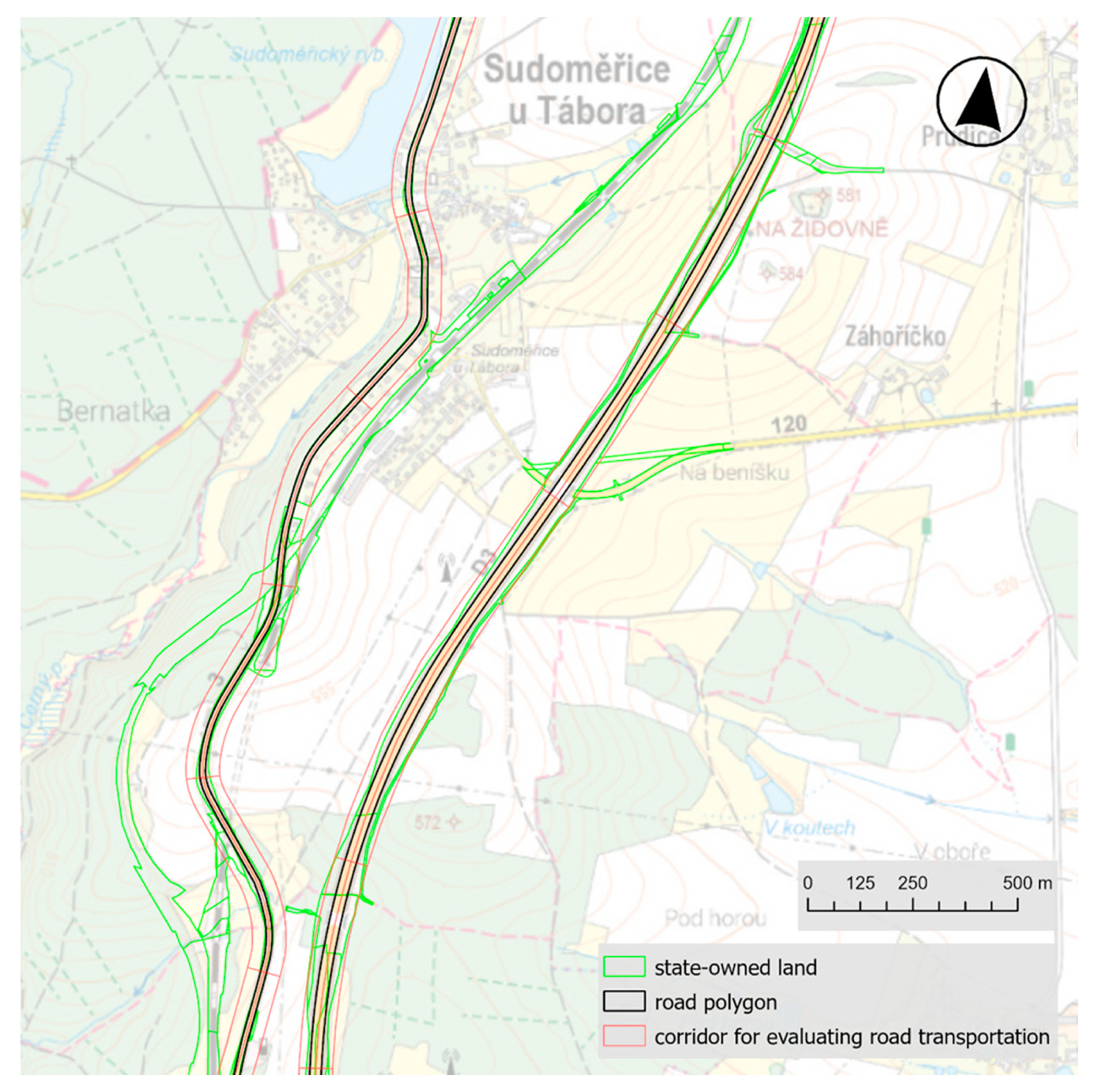
The detailed perspective of the road traffic assessment is presented in Figure 3. In this detailed view, the assessment of the transport network of the Czech Republic (road and rail) was published in a set of specialized maps [35].

2.2. Evaluation of Railway Transportation

To assess the feasibility of installing water-transfer infrastructure along the existing railway tracks, a similar approach was used; nevertheless, the process of obtaining the railway line data was different. A linear dataset was provided, which included information about the number of tracks on each line. After reviewing the data, the collective of authors kept only the lines with 1 or 2 tracks. Lines with more tracks were removed, as they mostly represented stations in urban areas, not corridors connecting different regions.
In the next step, a corridor layer for the railway lines was created, using the same method as for the road transportation corridors (40 m wide on each side and 500 m long). Then, the railway line polygons were made. As already mentioned, the number of tracks was used as an attribute. A width of 7 m was chosen for a single track and 10 m for two tracks [36]. These widths were derived from current aerial maps of the Czech Republic. A buffer zone was then created around the dataset to represent the area of railway corridors. The subsequent procedure for assessing the suitability of installing water-transfer infrastructure was the same as for road transportation, including the evaluation scale (see Table 2).
The requirements for computing technology were not an issue for the present study. The primary variable in relation to the complexity of the analysis is the size of the area being analyzed. The presented spatial analyses were carried out on a high-performance desktop computer equipped with an Intel Core i9-13900K processor (24 logical cores), 64 GB of RAM, and the Windows 11 Pro operating system.

2.3. Case Study—Connecting the Nýrsko Water Source with the City of Plzeň

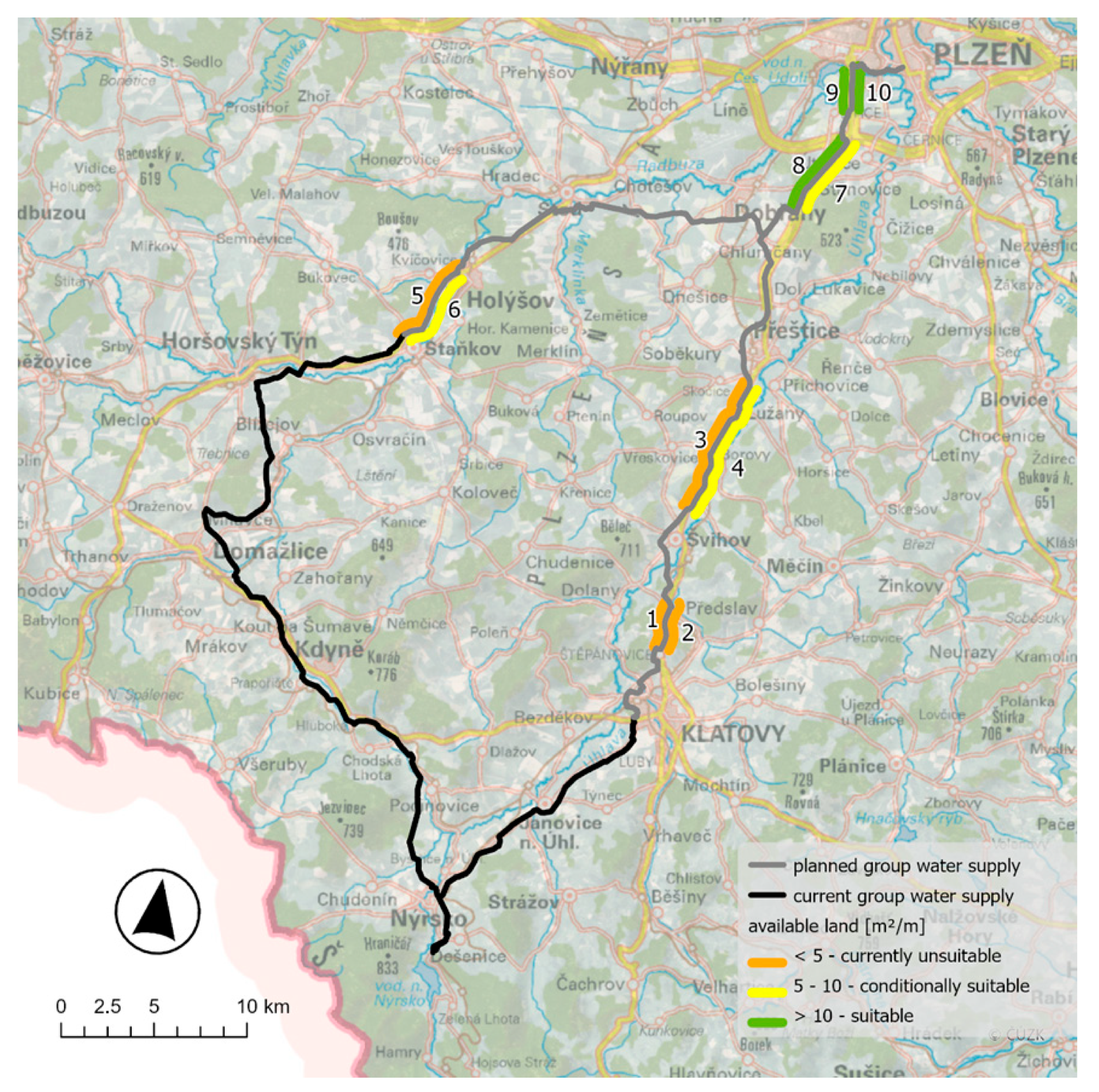
A thorough analysis was conducted to assess the capacities of local water resources and the feasibility of establishing connections through transport infrastructure at a pilot case study located in southwest Bohemia. The main objective is to connect the existing water supply systems to the local water sources and to ring-fence the water supply network in the area, which would improve the availability of drinking water in the region. The area is delineated from the city of Pilsen to Klatovy town, with a branch through the towns of Holýšov and Domažlice. The aim is to ensure the supply of drinking water from a stable and quality source in the Nýrsko surface reservoir to the maximum extent of the territory for the districts of Klatovy, Domažlice, and Plzeň-South using the existing group water supply. An overview of the Pilsen—Nýrsko case study (P–N case study) is presented in Figure 4.
The proposed and analyzed routing of the planned group water supply system is based on the idea to expand the area around Domažlice—Horšovský Týn—Holýšov (Domažlice branch) and Švihov—Přeštice (Klatovy branch) and to build a new connection to Pilsen, where this new system will be connected to the existing Pilsen water supply network. Thanks to the proposed new connection from Nýrsko to Plzeň, the entire water supply system would be ringed. The final situation is expected to ensure security of the water supply and will strengthen the current sources of the local group water supply systems of the adjacent areas. This interconnection will also create the possibility of connecting municipalities that do not have a water supply system or those having a low-capacity water supply, as an option for emergency supply.
The water system interconnection case study focuses on supplying approximately 120,000 residents along the water pipeline route. The Domažlice branch includes a new 25 km long supply pipeline with a capacity of 124l/s, which will provide water for 58,000 people. The Klatovy branch includes a new 43.55 km long supply pipeline with a capacity of 222l/s, which will serve 62,000 inhabitants [37].

3. Results

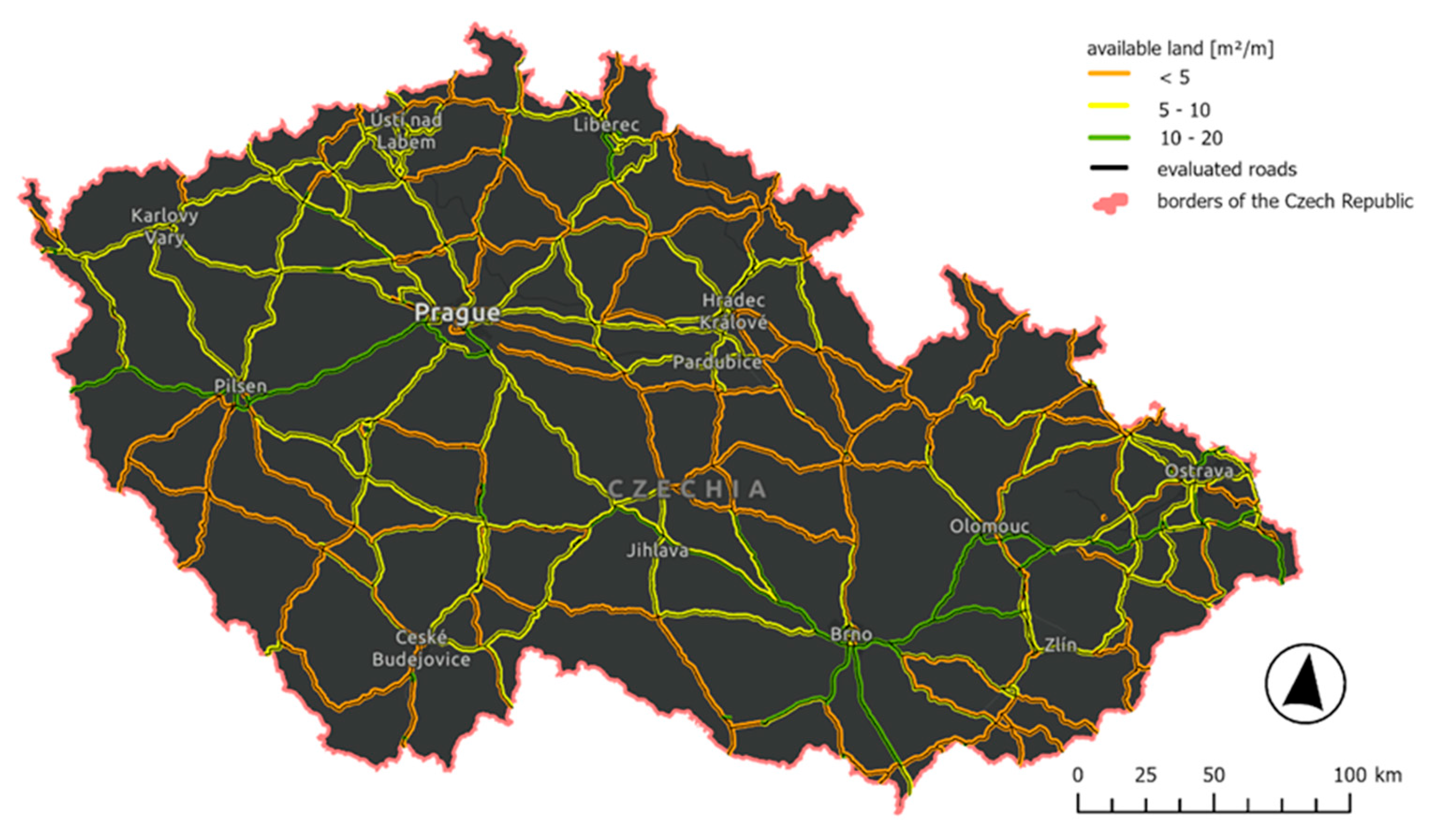
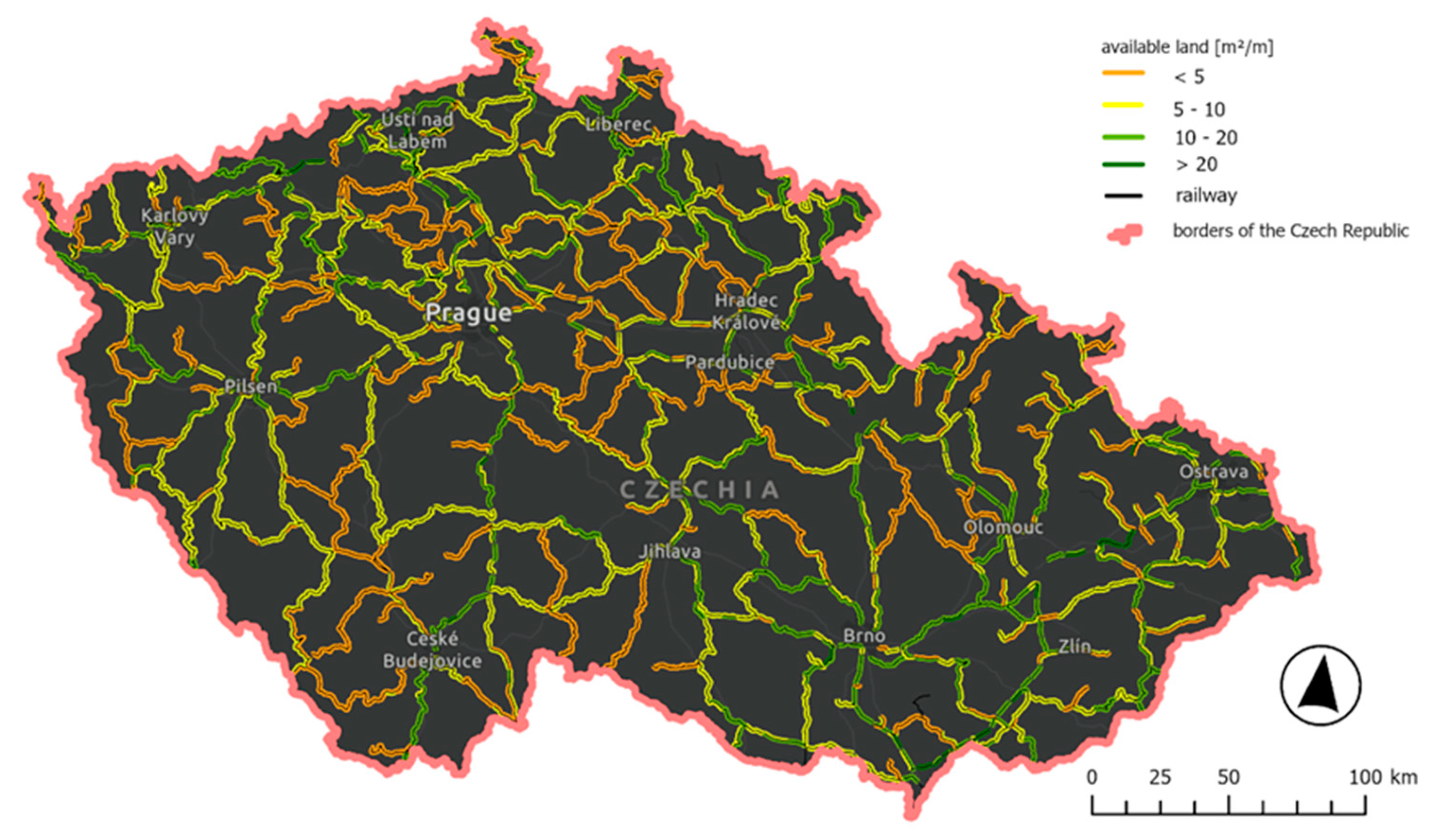
The following results were achieved by the assessment of all existing main transport corridors across the whole country. The individual sections of the transport network were assessed on both route sides, with a total of 26,852 road sections (500 m) with a total length of 7105.8 km and 31,243 railway sections (500 m) with a total length of 7812.9 km. For the presentation in Figure 5 and Figure 6, the 500 m sections were merged into longer sections. In the case of roads, these are the sections from intersection to intersection. In the case of railways, these are the sections that resulted from data cleaning (removing multi-track sections); see Figure 5 and Figure 6.
The presented spatial analysis carried out on the actual data of railway lines and roads in combination with state-owned land can be considered as an initial input for the possible planning of water supply infrastructure. This is a so-called 2D study, i.e., the spatial distribution of available land for possible water supply infrastructure for transporting drinking water or utility water. Aspects such as the morphology or the routing and cross-intersection of other technical infrastructure (electricity networks, telecommunications infrastructure, etc.), especially in the case of railways, were not taken into account due to the scale of the study. The overall results for all the sections assessed are presented in Table 3.
For the assessment of the availability of land for the water supply infrastructure in the presented case study, the same method was applied as for the whole country assessment, and the same input data were used. The difference was the evaluation of the total length of the selected section rather than a section-by-section evaluation of approximately 500 m. In summary, five road sections with a total length of 21.8 km were evaluated for the case study. As for the national scale, the sections were assessed at both route sides. The results of the available land for water supply infrastructure for the P–N case study are presented in Figure 7.
Detailed information on the sections evaluated (length, available area) in the P–N case study is presented in Table 4. The sections are sorted downwards according to the proportion of available land in each section.

4. Discussion

As revealed by the results of the present study, routing water infrastructures along roads and railways has certain advantages, but also specific risks and limitations. The main advantage is the already implemented infrastructure corridor, which means that the surrounding land is more suitable for public use than land in open space. This also reduces the cost, depending on the need to purchase smaller areas of such land. It also reduces the likelihood to expropriate land rather than build new corridors. Another advantage is better accessibility for pipeline repair or maintenance. Road and rail corridors are often protected from changes in zoning, minimizing the risk of changes during future commercial or residential development.
The main disadvantages of routing water supply infrastructure in road and rail corridors include conflicts with existing technical infrastructure. This can increase costs when dealing with avoidance of the already installed electrical cables, gas pipelines, sewers, etc. In the case of railways, the need for vibration protection should also be considered. Another potential risk that could arise in the event of a pipeline accident is the restriction of traffic at the site of the accident. In the event of a major incident, the accident itself could damage the road or railway [38]. Transport corridors also have protection zones in which established regulations regarding the subsequent installation of technical infrastructure must be respected.
The current legal framework regulating protective zones around transport corridors in Czechia is primarily based on safety and operational requirements of roads and railways. Water pipelines can be located within these zones with the consent of the relevant authority, which means that the proposed approach is feasible under the existing legislation. The question of whether the extent of protective zones should be modified goes beyond the scope of this study and should be addressed in a broader interdisciplinary context.
Although Czech legislation does not define a uniform minimum distance between roads or railways and water pipelines, the placement of technical infrastructure is regulated by protective zones of transport corridors. According to the Act on Roads, the protective zone is 100 m from the axis of the adjacent lane for motorways and expressways, 50 m for first-class roads, and 15 m for second- and third-class roads [39]. According to the Act on Railways, the protective zone of railways is generally 60 m from the axis of the outer track [40]. Water pipelines can be located within these zones only with the consent of the respective authority (road administration office, Railway Authority). In addition, water pipelines have their own protective zone defined by the Act on Water Supply and Sewerage Systems [41] and by the relevant technical standard (ČSN 75 5409—Design of Water Mains), which requires 1.5 m on each side of the pipe wall [42]. These requirements must be considered in project-level documentation, while the method presented in this study serves as a screening-level spatial analysis.
From an environmental perspective, routing water pipelines along existing road corridors generally reduces land take and landscape fragmentation by concentrating infrastructure within already developed zones. However, this may introduce cumulative environmental pressures due to the coexistence of multiple utility networks and carries a higher risk of contamination in the event of pipeline failure. In contrast, routing outside road corridors offers more spatial flexibility but often results in greater environmental disruption, including increased habitat fragmentation, land acquisition demands, and impacts on ecologically sensitive areas.
From the perspective of road and rail corridor assessment elaborated in this study, the biggest challenge was the preparation or harmonization of input datasets and the establishment of a methodological procedure. The harmonization of data for the whole country and the methodological procedure for their processing were developed gradually regarding the relevance of the results achieved.
The results of the whole country assessment are presented in Table 3, and illustrate that the potential for routing water supply infrastructure in road and rail corridors is significant in terms of the spatial distribution of available land. For the road corridors assessed, 23.6% of the road segments fall into the very suitable (20–40 m2/m) and suitable (10–20 m2/m) categories, with a total road length of up to 3303.7 km. In the case of rail corridors, 25.7% of the assessed sections with a total length of 4 018.4 km fall into the two most suitable categories. Information on land availability is only a small part of water infrastructure planning but can be very useful in terms of costs.
Routing water supply pipelines in road and rail corridors appears to be a promising option, given land prices and the unwillingness of current owners to sell/provide them. A profoundly greater potential for water-transfer infrastructure allocation can be seen in the planned transport corridors. Here, it is advisable to anticipate the routing of both lines in advance and reflect this when purchasing land for the transport corridor. Determining the need for water transfers, as well as the appraisal of water resources also in relation to the anticipated climate change and the demographic development, were addressed by the authors in the follow-up part of the research [43].
When evaluating the results for the N–P case study (Table 4), we can see relatively good results for half of the evaluated sections (ID—10, 8, 9, 4, 7) with a total length of 21.15 km. However, in the case of sections 10, 9, 8, and 7, there is a duplication of evaluation of the same road section, only from each side separately. The remaining sections on average did not show much availability of state-owned land, and the area will still need to be secured when the drinking water supply pipeline is implemented.
It should be emphasized that this study represents a screening approach aimed at assessing the potential of state-owned land along transport corridors at the national scale. The method has been intentionally simplified and relies on available national datasets, which makes it suitable for a rapid identification of areas with higher potential. However, for detailed project planning of water supply pipelines, it is necessary to integrate additional factors, in particular geological and topographic conditions, hydrogeological characteristics, as well as the presence and capacity of other utility networks. Therefore, the proposed procedure should be understood as a first step of the assessment, providing a baseline layer for subsequent, more detailed analyses at the local scale.
When considering such an approach and solution, the appropriate data and techniques for the inquiry of other installed linear structures, such as electrical cables, gas pipelines, sewers, etc., are to be applied. Further, especially regarding the railway corridors, the issue of vibration protection is to be inevitably considered. All these aspects were not analyzed in this study; nevertheless, the authors are aware of these items and consider them as necessary, in particular at the local scale of such a study.
Future research will focus on a variant assessment of water pipeline routes—both with the maximum use of road and railway corridors and outside these corridors—with particular emphasis on the comparison of economic factors, especially differences in land acquisition costs (state vs. private ownership) and related investment expenditures.

5. Conclusions

Water transfers from surplus to deficit areas appear as an inevitable and reasonable solution to overcome water scarcity, which tends to increase across the planet and Europe as well. In densely populated regions, the availability of land for effective placement of water-transfer infrastructures may be challenging as related to landscape permeability, reflecting landowner unwillingness to participate or the related financial outlays. As discovered in this study, the routing of water-transfer infrastructures along roads and railways can be advantageous in terms of lower land acquisition costs, access to infrastructure, and easier coordination. However, it is also necessary to carefully consider technical, legal, and safety factors that can affect the feasibility and the costs of construction and maintenance. The results of the present study, whether for the whole country assessment or within the case study, show that the potential for a given use of already state-owned land is considerable. However, there exist many other factors that influence the final routing of the water pipeline, which were not considered within the scope of the study. Therefore, future research will focus on variant pipeline routing assessments (e.g., different corridor distances from roads and railways) and ownership-based comparisons between state and private land, in order to validate and refine the presented screening approach.

Author Contributions

Conceptualization, Š.M., P.F., T.H., Š.Z. and O.M.; formal analysis, Š.M. and T.H.; resources, Š.M. and T.H.; writing—original draft preparation, Š.M. and P.F.; writing—review and editing, Š.M., P.F., T.H., M.K., Š.Z. and O.M. All authors have read and agreed to the published version of the manuscript.

Funding

This research was funded by the National Agricultural Research Agency, Grant numbers QK21010310 and QL24020321, and by the Ministry of Agriculture of the Czech Republic, Grant No. MZE-RO0223.

Institutional Review Board Statement

Not applicable.

Informed Consent Statement

Not applicable.

Data Availability Statement

The data that support the findings of this study were provided under license for the purposes of this research project. The datasets (including transport networks and cadastral layers) are not publicly available due to licensing restrictions, but are available upon request from the respective authorities: Road transport networks 1—Transport Research Centre (CDV) (2025); Centre for Transport Research [online], available at: https://www.cdv.cz/en/ (accessed on 21 January 2025); Road transport networks 2—Czech Office for Surveying, Mapping and Cadastre (ČÚZK) (2025); ZABAGED—Metadata for road layer (CZ-CUZK-TN_ROAD-V) [online], available at: https://geoportal.cuzk.cz/(S(t4uthtfesbahufhkxqzcvbly))/Default.aspx?lng=EN&mode=TextMeta&side=zabaged&metadataID=CZ-CUZK-TN_ROAD-V&mapid=8&menu=248 (accessed on 21 January 2025); Railway transport networks—Czech Office for Surveying, Mapping and Cadastre (ČÚZK) (2025). ZABAGED—Metadata for rail layer (CZ-CUZK-TN_RAIL-V) [online], available at: https://geoportal.cuzk.cz/(S(t4uthtfesbahufhkxqzcvbly))/Default.aspx?lng=EN&mode=TextMeta&side=zabaged&metadataID=CZ-CUZK-TN_RAIL-V&mapid=8&menu=247 (accessed on 21 January 2025); Cadastral data—Czech Office for Surveying, Mapping and Cadastre (ČÚZK) (2025); RÚIAN—Metadata for dSady layer [online], available at: https://geoportal.cuzk.cz/(S(t4uthtfesbahufhkxqzcvbly))/Default.aspx?mode=TextMeta&text=dSady_RUIAN&menu=31 (accessed on 21 January 2025).

Conflicts of Interest

The authors declare no conflicts of interest.

References

  1. WHO/UN-Water, Water-Related Challenges, UN.org. 2023. Available online: https://www.un.org/en/global-issues/water (accessed on 9 July 2025).
  2. Söller, L.; Luetkemeier, R.; Müller Schmied, H.; Döll, P. Groundwater stress in Europe—Assessing uncertainties in future groundwater discharge alterations due to water abstractions and climate change. Front. Water 2024, 6, 1448625. [Google Scholar] [CrossRef]
  3. Wojkowski, J.; Wałęga, A.; Młyński, D.; Radecki-Pawlik, A.; Lepeška, T.; Piniewski, M.; Kundzewicz, Z.W. Are we losing water storage capacity mostly due to climate change? Analysis of the landscape hydric potential in selected catchments in East-Central Europe. Ecol. Indic. 2023, 154, 110913. [Google Scholar] [CrossRef]
  4. Debaere, P.; Kapral, A. The potential of the private sector in combating water scarcity: The economics. Water Secur. 2021, 13, 100090. [Google Scholar] [CrossRef]
  5. European Environment Agency. Europe’s State of Water 2024: The Need for Improved Water Resilience; EEA Report No 07/2024; Publications Office of the EU: Luxembourg, 2024. [Google Scholar] [CrossRef]
  6. Siddik, M.A.B.; Dickson, K.E.; Rising, J.; Emanuel, R.E.; Duvall, A.; Lin, Y.-P.; Ruddell, B.L. Interbasin water transfers in the United States and Canada. Sci. Data 2023, 10, 27. [Google Scholar] [CrossRef] [PubMed]
  7. Cirilo, J.A.; Ribeiro Neto, A.; Ramos, N.M.R.; Fortunato, C.F.; de Souza, J.D.S.; Bezerra, S.d.T.M. Management of water supply systems from interbasin transfers: Case study in the Brazilian semiarid region. Urban Water J. 2021, 18, 660–671. [Google Scholar] [CrossRef]
  8. Bernabé-Crespo, M.B.; Loáiciga, H. Managing potable water in southeastern Spain, Los Angeles, and Sydney: Transcontinental approaches to overcome water scarcity. Water Resour. Manag. 2024, 38, 1299–1313. [Google Scholar] [CrossRef]
  9. Dobbs, G.R.; Liu, N.; Caldwell, P.V.; Doyle, M.W.; Konar, M. Inter-basin surface water transfers database for public water supplies in conterminous United States, 1986–2015. Sci. Data 2023, 10, 255. [Google Scholar] [CrossRef]
  10. Laassilia, O.; Ouazar, D.; Bouziane, A.; Hasnaoui, M.D. Estimation of excess water in the Sebou basin for an interbasin water transfer. J. Appl. Water Eng. Res. 2021, 9, 69–87. [Google Scholar] [CrossRef]
  11. Murgatroyd, A.; Gavin, H.; Becher, O.; Coxon, G.; Hunt, D.; Fallon, E.; Wilson, J.; Cuceloglu, G.; Hall, J.W. Strategic analysis of the drought resilience of water supply systems. Philos. T. Roy. Soc. A 2022, 380, 20210292. [Google Scholar] [CrossRef]
  12. Liu, Y.; Xin, Z.; Sun, S.; Zhang, C.H.; Fu, G. Assessing environmental, economic, and social impacts of inter-basin water transfer in China. J. Hydrol. 2023, 625 Pt A, 130008. [Google Scholar] [CrossRef]
  13. Kuhn, D.; Luetkemeier, R.; Frick-Trzebitzky, F.; Söller, L.; Fehrs, K. Infrastructural lock-ins in the temporal and spatial development of a long-distance water transfer in Germany. J. Hydrol. 2024, 634, 131070. [Google Scholar] [CrossRef]
  14. Faúndez, M.; Echeverría, D.; Díaz, A.; Peña, H.; Vargas, X. Sustainability of water transfer projects: A systematic review. Sci. Total Environ. 2023, 860, 160500. [Google Scholar] [CrossRef]
  15. Wang, X.; Dong, Z.; Wang, W.; Tan, Y.; Zhang, T.; Han, Y. Regional water allocation for coordinated development among the social, economic and environmental systems. AQUA—Water Infrastruct. Ecosyst. Soc. 2021, 70, 550–569. [Google Scholar] [CrossRef]
  16. Purvis, L.; Dinar, A. Are intra- and inter-basin water transfers a sustainable policy intervention for addressing water scarcity? Water Secur. 2020, 9, 100058. [Google Scholar] [CrossRef]
  17. Khadem, M.; Watts, G.; Dadson, S.; Tanguy, M.; Hannaford, J. The feasibility of inter-basin water transfers to manage climate risk in England. Clim. Risk Manag. 2021, 33, 100322. [Google Scholar] [CrossRef]
  18. Rollason, E.; Sinha, P.; Bracken, L.J. Interbasin water transfer in a changing world: A new conceptual model. Prog. Phys. Geog. 2022, 46, 371–397. [Google Scholar] [CrossRef]
  19. Zhong, H.; Liao, T.; Fang, G.; Ren, K.; Zhang, S. Exploring optimal joint operating rules for large-scale inter-basin water transfer projects with multiple water sources, diversion routes, and water demand areas. J. Hydrol. Reg. Stud. 2023, 49, 101504. [Google Scholar] [CrossRef]
  20. Ministry of Agriculture of the Czech Republic. Report on the State of Water Management in the Czech Republic in 2023. 2023. Available online: https://mze.gov.cz/public/portal/mze/-a52982---T_okw9lF/zprava-o-stavu-vodniho-hospodarstvi-ceske-republiky-v-roce-2023?_linka=a597886 (accessed on 9 July 2025).
  21. Caithamlová, M.; Kročová, Š.; Mariňáková, J. Operation of water supply systems in the Czech Republic—Risk analysis. Appl. Sci. 2024, 14, 1572. [Google Scholar] [CrossRef]
  22. Hejduková, P.; Marval, Š.; Roub, R.; Zrostlík, Š.; Kopp, J.; Hejduk, T.; Sychová, P.; Kureková, L.; Pavlíčková, L.; Bureš, L.; et al. Dostupnost Pitné Vody pro Obyvatele Malých Obcí jako Indikátor Socio-Ekonomického Rozvoje Společnosti. Certifikovaná Metodika. 2021. Available online: https://agronavigator.cz/sites/default/files/users/user291/Metodiky/e_metodika_zapivo.pdf (accessed on 9 July 2025).
  23. Hejduková, P.; Zrostlík, Š.; Hejduk, T. Propojování Vodárenských Soustav jako Efektivní Řešení pro Zajištění Kvalitního Zdroje Vody. TZB-info. 2022. Available online: https://voda.tzb-info.cz/vlastnosti-a-zdroje-vody/23440-propojovani-vodarenskych-soustav-jako-efektivni-reseni-pro-zajisteni-kvalitniho-zdroje-vody (accessed on 9 July 2025).
  24. Meitner, J.; Štěpánek, P.; Skalák, P.; Dubrovský, M.; Lhotka, O.; Penčevová, R.; Zahradníček, P.; Farda, A.; Trnka, M. Validation and selection of a representative subset from the ensemble of EURO-CORDEX EUR11 regional climate model outputs for the Czech Republic. Atmosphere 2023, 14, 1442. [Google Scholar] [CrossRef]
  25. Kundzewicz, Z.W.; Mata, L.J.; Arnell, N.W.; Döll, P.; Kabat, P.; Jiménez, B.; Miller, K.A.; Oki, T.; Sen, Z.; Shiklomanov, I.A. The implications of projected climate change for freshwater resources and their management. Hydrol. Sci. J. 2008, 53, 3–10. [Google Scholar] [CrossRef]
  26. Vizina, A.; Vysoč, P.; Kožín, R.; Nováková, H. Potenciál chráněných území pro akumulaci povrchových vod pro zmírnění dopadů klimatické změny na zásobování pitnou vodou. Vodohospodářské Tech.-Ekon. Inf. 2023, 65, 32–41. [Google Scholar] [CrossRef]
  27. Raj, S.; Bansal, V.K. Use of GIS for selection of optimal route for water pipelines in hill areas. Innov. Infrastruct. Solut. 2024, 9, 13. [Google Scholar] [CrossRef]
  28. Minaei, A.; Abusamra, S.; Hajibabaei, M.; Savic, D.; Zecchin, A.C.; Creaco, E.; Sitzenfrei, R. Optimized phased planning for dynamic rehabilitation of integrated municipal infrastructure. AQUA—Water Infrastruct. Ecosyst. Soc. 2024, 73, 1389–1405. [Google Scholar] [CrossRef]
  29. Mosbach, J.; Krämer, M.; Fiedler, J.E.; Sonnenburg, A.; Urban, W. Combined districting and main line routing—A method to implement a basic drinking water supply infrastructure in informal settlements. Water 2022, 14, 2805. [Google Scholar] [CrossRef]
  30. Motiee, H.; Khalili, R.; Gholami, B.; Ghorbani, M.A.; Dastorani, M.T. A decision making approach for water transfer systems by Analytical Hierarchy Process (AHP) and GIS. Water Resour. Manag. 2023, 37, 4623–4637. [Google Scholar] [CrossRef]
  31. Czech Office for Surveying, Mapping and Cadastre (ČÚZK). INSPIRE Theme—Transport Networks—Road Transport; Data Specification and Accuracy of ZABAGED®; ČÚZK: Prague, Czech Republic, 2020; Available online: https://geoportal.cuzk.cz/(S(k5ihzevprysew0wfuwb0flko))/Default.aspx?lng=CZ&mode=TextMeta&side=zabaged&metadataID=CZ-CUZK-TN_ROAD-V&mapid=8&menu=248 (accessed on 2 September 2025).
  32. Czech Office for Surveying, Mapping and Cadastre (ČÚZK). INSPIRE Theme—Transport Networks—Rail Transport; Data Specification of ZABAGED; ČÚZK: Prague, Czech Republic, 2020; Available online: https://geoportal.cuzk.cz/(S(k5ihzevprysew0wfuwb0flko))/Default.aspx?lng=CZ&mode=TextMeta&side=zabaged&metadataID=CZ-CUZK-TN_RAIL-V&mapid=8&menu=247 (accessed on 2 September 2025).
  33. Czech Office for Surveying, Mapping and Cadastre (ČÚZK). Register of Territorial Identification, Addresses and Real Estate (RÚIAN); Data Documentation; ČÚZK: Prague, Czech Republic, 2024; Available online: https://vdp.cuzk.cz (accessed on 2 September 2025).
  34. European Parliament and Council of the European Union. Directive 2007/2/EC Establishing an Infrastructure for Spatial Information in the European Community (INSPIRE). Off. J. Eur. Union 2007, L 108, 1–14. [Google Scholar]
  35. Marval, Š.; Zrostlík, Š.; Hejduk, T.; Fučík, P.; Mašek, O.; Zajíček, A.; Poláková, L.; Slavík, P.; Kasal, R.; Anderlová, B. Využití Koridorů Dopravních Liniových Staveb k Dodávce Pitné a Závlahové vody do Deficitních Oblastí. In Specializovaná mapa s odborným obsahem; VUMOP: Prague, Czech Republic, 2024; p. 133. ISBN 978-80-88664-08-6. [Google Scholar]
  36. ČSN 73 6360-1; Czech Technical Standard ČSN 73 6360-1: Structural and Geometric Arrangement of Railway Tracks and Their Spatial Position—Part 1: Design. Czech Office for Standards, Metrology and Testing (ÚNMZ): Prague, Czech Republic, 2014.
  37. Zrostlík, Š.; Hyšplerová, M.; Mašek, O. Sjednocení Studií Proveditelnosti „Propojení Skupinových vodovodů Nýrsko-Klatovy, Švihov, Přeštice, Dobřany a Plzeňská aglomerace” a „Propojení vodovodu Nýrsko-Domažlice-Holýšov s Plzeňskou Aglomerací-SP”. 2022. Available online: https://www.plzensky-kraj.cz/sjednoceni-studii-proveditelnosti-propojeni-skupi (accessed on 9 July 2025).
  38. Mazumder, R.K.; Salman, A.M.; Li, Y.; Yu, X. Asset Management Decision Support Model for Water Distribution Systems: Impact of Water Pipe Failure on Road and Water Networks. J. Water Res. Plan. Man. 2021, 147, 04021022. [Google Scholar] [CrossRef]
  39. Act No. 13/1997 Coll., on Roads [Zákon č. 13/1997 Sb., o Pozemních Komunikacích]. Collection of Laws of the Czech Republic. Available online: https://www.zakonyprolidi.cz/cs/1997-13 (accessed on 2 September 2025).
  40. Act No. 266/1994 Coll., on Railways [Zákon č. 266/1994 Sb., o Drahách]. Collection of Laws of the Czech Republic. Available online: https://www.zakonyprolidi.cz/cs/1994-266 (accessed on 2 September 2025).
  41. Act No. 274/2001 Coll., on Water Supply and Sewerage Systems [Zákon č. 274/2001 Sb., o vodovodech a kanalizacích]. Collection of Laws of the Czech Republic. Available online: https://www.zakonyprolidi.cz/cs/2001-274 (accessed on 2 September 2025).
  42. ČSN 75 5409; ČSN 75 5409: Design of Water Mains [ČSN 75 5409: Navrhování vodovodních řadů]. Czech Office for Standards, Metrology and Testing: Prague, Czech Republic, 2012.
  43. Mašek, O.; Zrostlík, Š.; Hejduk, T.; Fučík, P.; Marval, Š.; Zajíček, A.; Poláková, L.; Kasal, R. Vyhodnocení Potřeby Vody pro Vodárenské Účely 2030+. In Specializovaná mapa s odborným obsahem; VUMOP: Prague, Czech Republic, 2024; 43p, ISBN 978-80-88664-02-4. [Google Scholar]
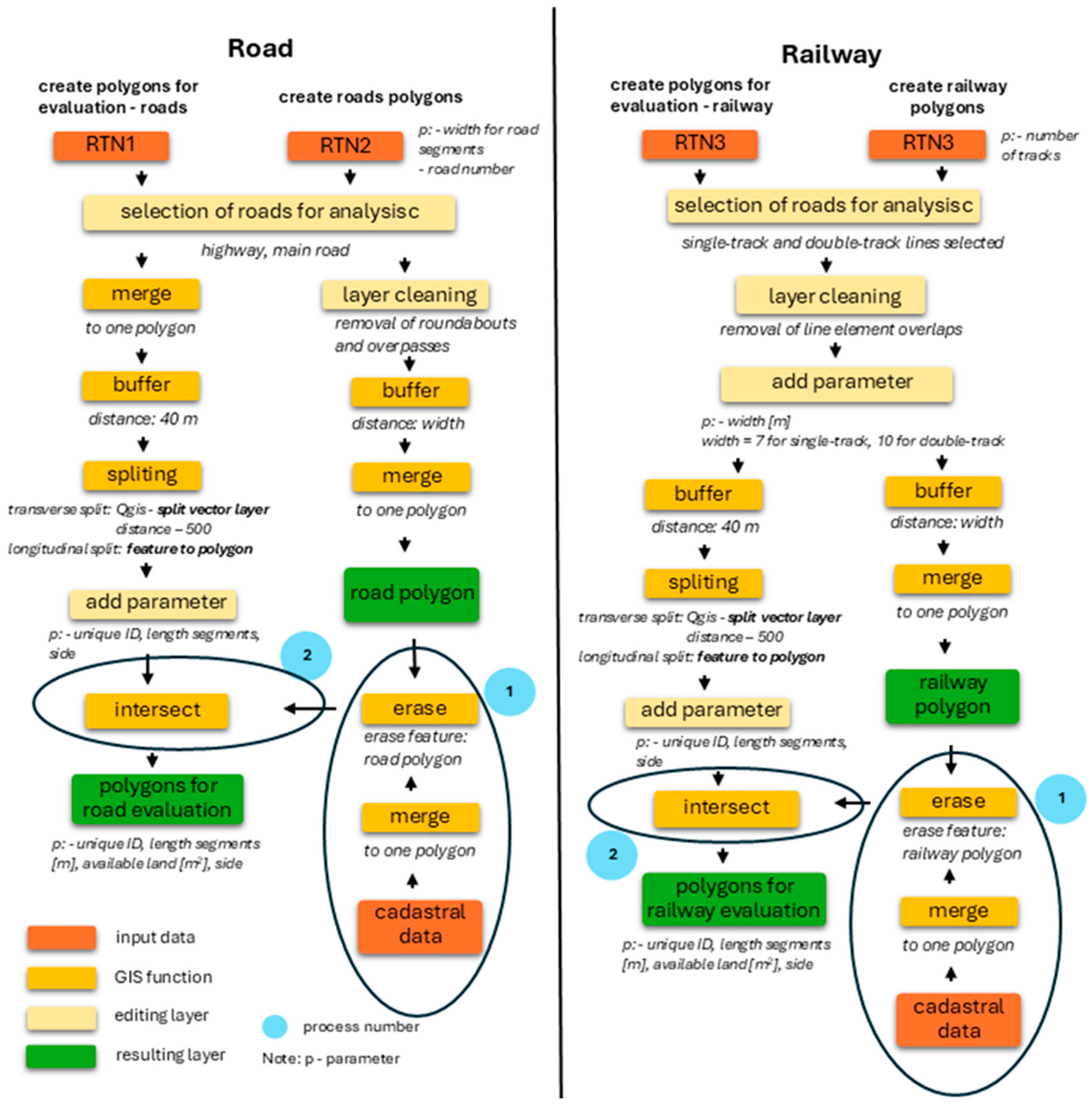
Figure 1. GIS workflow employed in this study to assess land availability for water transfers in transportation corridors.
Applsci 15 09990 g001
Figure 2. Overview of prepared data sources entered into the spatial analysis—an example for a highway, main road, and railway corridors.
Applsci 15 09990 g002
Figure 3. Example of the results of analyzing water infrastructure installation along the existing road.
Applsci 15 09990 g003
Figure 4. P–N case study overview. As part of the case study, a total of five road sections (evaluated on both sides) were selected for assessing the suitability of water-transfer infrastructure installation. The selection was based on the spatial proximity of the planned pipeline route to major roads, as identified in the study by [37].
Applsci 15 09990 g004
Figure 5. Network of assessed transport roads.
Applsci 15 09990 g005
Figure 6. Network of assessed railways.
Applsci 15 09990 g006
Figure 7. Assessment of selected sections within the P–N case study.
Applsci 15 09990 g007
Table 1. Overview of the original datasets used for analysis.
Dataset nameDataset DescriptionParametersData Source
Road transport networks 1 (RTN1)Spatial layout of road transportation—only single line for a road corridor (highways, expressways, and first-class roads); line.shpRoad transport networks geometryThe Transport Research Center
Road transport networks 2 (RTN2)Spatial layout of traffic lanes includes road width data—a line for each traffic lane (highways, expressways, and first-class roads), line.shpRoad transport networks geometry, road number, width for roadINSPIRE—Theme—Transport Networks—Road Transport—Dataset for Defining the Road Body
Railway transport networksSpatial layout of the railway transportation includes number of railway tracks, line.shpRailway transport networks geometry, number of tracksINSPIRE—Theme—Transport Networks—Rail Transport—Dataset for Defining the Railway Body
Cadastral dataLocalization of lands owned by the Czech Republic—Management rights for the Road and Motorway Directorate and the Railway Administration (RMDRA), polygon.shpLand parcel geometryCzech Office for Surveying, Mapping and Cadastre—Register of Territorial Identification, Addresses, and Real Estate
Table 2. Categories for assessing the suitability of water-transfer infrastructure installation. Not Assessed—category was created due to incomplete digitization of cadastral data.
Available Land (m2/m)Suitability of Water-Transfer Infrastructure Installation
0.00–40.00Very Suitable
10.00–20.00Suitable
5.00–10.00Conditionally Suitable
0.01–5.00Currently Unsuitable
0.00Not Assessed
Table 3. Results of the whole country assessment of the transport network.
Type of TransportCategoriesNumber of 500 m SectionsTotal Length [km]% by Type of Transport
roadvery suitable1411728.665.3
roadsuitable49022575.0418.3
roadconditionally suitable46882484.7817.5
roadcurrently unsuitable14,0927526.9952.5
roadnot assessed1759896.056.6
railwayvery suitable1534766.454.9
railwaysuitable65013251.9320.8
railwayconditionally suitable93254675.4529.8
railwaycurrently unsuitable12,5806289.0940.3
railwaynot assessed1303642.874.2
Table 4. Evaluation of road sections for water supply infrastructure in the P–N case study, ordered from most suitable.
Section IDType of RoadSuitability of Water-Transfer Infrastructure InstallationLength [km]Available Land [m2]Available Land [m2/m]
10expresswayssuitable2.2832,355.514.2
8expresswayssuitable4.4548,425.710.9
9expresswayssuitable2.2724,287.410.7
4first-class roadsconditionally suitable7.7172,626.39.4
7expresswaysconditionally suitable4.4440,846.99.2
6first-class roadsconditionally suitable4.9025,463.85.2
5first-class roadscurrently unsuitable4.8524,164.25.0
3first-class roadscurrently unsuitable7.7130,181.33.9
2first-class roadscurrently unsuitable2.488888.13.6
1first-class roadscurrently unsuitable2.468195.23.3
Disclaimer/Publisher’s Note: The statements, opinions and data contained in all publications are solely those of the individual author(s) and contributor(s) and not of MDPI and/or the editor(s). MDPI and/or the editor(s) disclaim responsibility for any injury to people or property resulting from any ideas, methods, instructions or products referred to in the content.