Abstract
The reconstruction of historic buildings requires the integration of diverse data sources, both geometric and non-geometric. This study presents a multi-source data analysis methodology for heritage reconstruction using 3D modeling and Historic Building Information Modeling (HBIM). The proposed approach combines geometric data, including point clouds acquired via Terrestrial Laser Scanning (TLS), with architectural documentation and non-geometric information such as photographs, historical records, and technical descriptions. The case study focuses on a wooden Orthodox church in Żmijowiska, Poland, analyzing geometric changes in the structure over multiple decades. The reconstruction process integrates modern surveys with archival sources and, in the absence of complete geometric data, utilizes semantic, topological, and structural information. Geometric datasets from the 1990s, 1930s, and the turn of the 20th century were analyzed, supplemented by intermediate archival photographs and technical documentation. This integrated method enabled the identification of transformation phases and verification of discrepancies between historical records and the building’s actual condition. The findings confirm that the use of HBIM and multi-source data fusion facilitates accurate reconstruction of historical geometry and supports visualization of spatial changes across decades.
1. Introduction
Documentation, analysis, and reconstruction of historic buildings represent key challenges in cultural heritage preservation. Heritage structures undergo numerous transformations over decades due to both natural degradation processes and conservation interventions [1,2,3]. Reconstruction is the process of restoring these structures to their original or presumed state based on available source data, analytical models, or machine learning algorithms. These efforts are particularly significant for historic and cultural heritage assets because of the need for their protection and documentation. Reconstruction encompasses not only geometric aspects (e.g., volume, proportions, surface morphology) but also non-geometric elements such as textures, materials, spatial context, and the symbolic meaning of the object or its components.
Contemporary approaches leverage integrated data sources and multi-level models to reconstruct both the structure of buildings and the changes they have undergone as accurately as possible [4]. Understanding these changes require an interdisciplinary approach that unifies geometric data—such as point clouds obtained through terrestrial laser scanning (TLS) [5,6], mobile scanning (MLS) [7], close-range photogrammetry [8], or UAV (Unmanned Aerial Vehicle) imaging [9] —with non-geometric data like iconography, monographs, and technical descriptions to enable a precise reconstruction of the building’s former state [1,3]. A significant tool supporting these efforts is Historic Building Information Modeling (HBIM)—an adaptation of BIM methodology tailored for heritage buildings, enabling the creation of semantically enriched parametric 3D models supplemented by historical data [1,10]. HBIM has evolved into not only a tool for inventory and reconstruction of heritage structures but also a technology that facilitates the monitoring of their technical condition and supports conservation decision-making. It can function as an interactive database that aids in heritage resource management [2].
For many years, photogrammetry and remote sensing tools and solutions have been used to generate technical documentation of heritage structures (orthophotos, technical documentation, and 3D object models) [11]. Thanks to their high accuracy and comprehensive data acquisition, these tools also provide valuable information for reconstruction efforts, offering detailed data on the current state of a structure [7]. A point cloud serves as an excellent basis for creating precise 3D models of historic structures, as it faithfully reproduces real geometry and spatial distribution. Due to its high density and measurement accuracy, even fine architectural details can be captured, making it an extremely valuable geospatial data source. Such data enable the creation of a reliable metric representation of a building, which forms the starting point for HBIM. Point clouds allow segmentation and parameterization of objects in ways that support heritage management and conservation documentation [12,13]. The popular recent “scan-to-HBIM” process, encompassing point cloud acquisition, semantic segmentation, and conversion into a BIM model, enables the faithful reconstruction of complex, irregular forms [14,15]. However, due to the fragmentation of historical data, it is necessary to supplement it with archival, descriptive, and photogrammetric information—an approach known as multi-source data fusion [16].
The integration of BIM and GIS data in a single environment significantly expands the capabilities for analyzing historical and contemporary spatial data, and also supports conservation planning. Combining information about a building’s structure with its geographic location enables better planning of conservation activities, documentation of changes over time, and analysis of environmental impact. This approach supports both 3D visualization and data interoperability in interdisciplinary environments [17]. A popular and increasingly used multi-scale approach allows spatial analysis at both the city level and the level of individual structures. Temporal change modeling (4D) allows tracking of building evolution, supporting design and protective decisions [18]. Extremely important in the context of historical reconstruction is the use of multi-source data. The basis for acquiring a complete set of information necessary for reconstruction is the development of an integrated methodology for documentation and analysis of building changes, taking into account various data sources (photographs, plans, TLS), aimed at reconstructing architectural evolution and integration in an HBIM environment [19]. Even with limited geometric data, thanks to support from semantic sources and other non-geometric forms of documentation and descriptions of the object, it is possible to reconstruct its historical state based on architectural records and narratives of change [14].
The synergy of data has become the primary tool ensuring comprehensive information acquisition and model development. Integrating data from terrestrial laser scanning (TLS) and UAV photogrammetry provides an extremely effective solution for comprehensive 3D modeling in HBIM technology. Combining these methods allows full representation of both architectural details and hard-to-access elements of roofs and facades. This data synergy increases model completeness and georeferencing accuracy, which is crucial for further conservation and design analyses. The combination of TLS and UAV has become a standard approach in heritage documentation, especially for structures with complex spatial configuration [20,21]. The fusion of these data particularly fills in information gaps where standalone methods are limited—TLS provides high-precision facade documentation, while UAV data enables capturing inaccessible roof surfaces and high-altitude architectural details. Thanks to this integration, it is possible to more effectively monitor the technical condition of historical structures, diagnose damage, and plan conservation actions, significantly enhancing the value of cultural heritage documentation and analyses [22]. Hybrid 3D models, based on integration of UAV, TLS, MLS, and terrestrial photogrammetry data, enable documentation of extensive and complex heritage structures within a unified reference system. The fusion of data with varying resolutions, accuracies, and scales preserves full geometry, texture, and spatial context of structures. Key quality factors of the model include geometric completeness, radiometric consistency, and format interoperability [23]. Multiplatform integration of measurement data enables achieving consistency and accuracy comparable to direct field measurements. The synergy of techniques (GNSS, TLS, total station, orthophoto mapping) ensures a more complete spatial representation and eliminates gaps arising from single-source limitations. A shared geodetic reference enables precise integration of data in various formats. Statistical methods support quality assessment of integration, thus enhancing result reliability. This approach is applied not only in map preparation, database updates, and documentation of urbanized areas but also in 3D modeling within BIM technologies [24]. Automated HBIM model generation via semantic segmentation of point clouds using deep neural networks is also becoming increasingly popular. This method relies on automatic object detection algorithms, enabling classification of architectural elements and their transformation into parametric BIM objects. Applying this approach can significantly accelerate geometric reconstruction of historic architectural structures, especially for large 3D datasets [6,20].
The mentioned approaches clearly demonstrate the potential of modern data acquisition methods in cultural heritage reconstruction; however, there remains a lack of methodology allowing comprehensive mapping of the geometry of historical structures over a long temporal horizon. A clear research gap exists in integrating data from different eras, of varying nature and accuracy—particularly in combining geometric data, such as point clouds or 3D models, with non-geometric information, including historical photographs, technical plans, and architectural descriptions. There is also a lack of clear methods for comparative analysis of building geometry across different periods of their existence, which significantly hinders understanding of transformation processes and their documentation within the HBIM environment.
1.1. Aim and Novelty of the Paper
The aim of this study is to develop and test an integrated methodology for reconstructing historical architectural objects based on multi-source data, both geometric and semantic. Particular emphasis is placed on analyzing geometric changes over several decades and applying the HBIM environment as a platform for data integration and reconstruction support. The research focuses on correlating contemporary and archival data, analyzing discrepancies between the actual and documented states of a building, and attempting to recreate its earlier development phases despite limited geometric data availability.
The presented approach demonstrates clear innovation, primarily resulting from its profound interdisciplinarity and the high level of accuracy and reliability maintained in the developed models. The novelty of the proposed methodology lies in its integration of diverse fields of knowledge—from heritage conservation, through historical, architectural, and artistic studies, to precise geodetic and technical analyses. Applying a reverse-chronological method enabled a comprehensive and credible reconstruction covering all architectural transformations that the studied object underwent throughout the last 144 years. The innovative aspect of this method involves simultaneously combining interdisciplinary data sources, ranging from precise geometric information obtained via terrestrial laser scanning and photogrammetry, through archival technical documentation and historical photography, to stylistic, historical, and semantic analyses. All gathered information was integrated into a precise, metric-based 3D model integrated with a timeline, allowing thorough tracking and detailed analysis of the object’s evolution over nearly a century and a half. Unlike typical HBIM studies, which often focus on a selected period or a few fragmented phases, this research leaves no stage of transformation unaddressed, meticulously reconstructing even minimally documented elements. Such an approach marks a significant step forward for digital cultural heritage reconstruction, setting new standards for chronological accuracy and geometric precision that can guide future studies.
1.2. Organization of the Article
This article is organized into five main sections. The Section 1 introduces the background of the study, defining its objectives and scope. The Section 2 details the materials and methods, including the methodology for digital reconstruction, the data sources, and the case study of the wooden Orthodox church in Żmijowiska. The Section 3 presents the results of the multi-stage digital reconstruction and an analysis of the geometric transformations of the church across four key historical periods. The Section 4 discusses these findings in the context of heritage reconstruction and HBIM methodology. Finally, the Section 5 concludes the paper and suggests directions for future research and practical applications.
2. Materials and Methods
2.1. Research Methodology
The aim of this study is to develop and verify a methodology for reconstructing historic buildings through analysis of changes in their geometry over time. The work focuses on integrating geometric and non-geometric data to accurately represent earlier developmental phases of a chosen heritage object. A key assumption is the use of diverse sources—including terrestrial laser scanning (TLS) data, architectural documentation, archival photographs, as well as semantic and topological information—to build a coherent, chronological 3D model within an HBIM environment.
The study attempts to answer how to effectively integrate technologically diverse data from multiple disciplines and periods, how to coordinate and ensure their consistency, and how to accurately identify and represent geometric changes in a structure over a defined time span. The specific subject of analysis is the case of the wooden Orthodox church in Żmijowiska (Poland), which represents a historical structure with a complex form that has undergone several transformations over more than 100 years. The scope includes four selected time points, listed in reverse chronological order: the current state (2024/2025), the state of the structure as of 1990, 1930, and the building layout from 1881. Each stage was reconstructed based on the most complete available source data: TLS point clouds (for the present state), architectural, iconographic, and descriptive documentation (for the 1990s), and architectural, iconographic, primary sources, art-historical studies, and architectural surveys (for 1930 and 1881). In cases where geometric data were incomplete or unavailable, the reconstruction of shapes and dimensions of specific elements was based on the above-mentioned information, as well as construction schematics, stylistic and comparative analysis, conservation research, and spatial context analysis, allowing for the most precise reconstruction of the structure given source constraints.
The proposed methodology includes documenting the current state, followed by—using reverse chronology—a gradual reconstruction of earlier forms based on the available diverse sources of knowledge about the structure. This approach treats non-geometric data as a fully legitimate information source used in 3D modeling and visualization. Such an approach enables faithful reproduction of the shape of the object as it existed in the past, even with limited access to geometric data. This methodology assumes comprehensive integration of data from various sources and of differing structures, allowing for precise analysis of the building’s spatial transformation in a historical context. As a result, HBIM becomes not only a modeling environment but also a tool supporting documentation, analysis, and interpretation of architectural heritage. The interdisciplinary nature of the study combines knowledge from civil engineering, architecture, art history, and computer science. The conducted research provides new tools for historical building reconstruction, enabling precise representation of their geometric changes and supports the development of HBIM as a documentation platform in the field of cultural heritage protection.
In the reconstruction process of the historic heritage object, diverse sources of geometric and non-geometric (semantic) data were utilized, along with intermediate data types blending both categories. The fundamental and most precise geometric data source was the point cloud obtained through Terrestrial Laser Scanning (TLS). The TLS data, characterized by high spatial resolution and measurement reliability, formed the basis for a detailed inventory of the current state of the object and served as the initial reference for reconstructing its historical forms. Additionally, supplementary geometric data were derived from historical technical documentation, enabling the restoration of original spatial arrangements, proportions, and architectural details that had been altered or lost over time. In cases where technical documentation was insufficient, archival photographs provided essential support, supplying geometric information regarding the form, dimensions, and composition of structural elements, as well as semantic details for identifying characteristic construction materials, technical features, and stylistic approaches. Semantic (non-geometric) data were acquired primarily from historical records, conservation documentation, literature sources, and expert analyses conducted by architectural historians and heritage conservators. These sources offered profound insights into the object’s historical background, regional and period-specific construction techniques, material characteristics, and stylistic and symbolic attributes of individual architectural components. In instances where the availability of precise geometric data was particularly limited or insufficient, comparative stylistic analysis was employed, based on analogous historical objects sharing similar periods of origin, geographic locations, and construction styles. This methodological approach facilitated the credible reconstruction of poorly documented or entirely destroyed architectural components. By integrating these interdisciplinary sources—comprising detailed TLS measurements, historical documentation analyses, iconographic interpretations, assessments of preserved and dismantled architectural elements, and comparative methodologies—it was possible to comprehensively, accurately, and reliably reconstruct successive phases of the historical development of the studied heritage object.
2.2. Case Study
The research object is the former Greek Catholic church of the Dormition of the Mother of God in Żmijowiska (Wielkie Oczy commune, Jarosław County, Podkarpackie Voivodeship, Poland (Figure 1)). It is a monument from the second half of the 18th century, registered in the Podkarpackie Voivodeship heritage register under No. A-779. The church complex is located on the eastern edge of the village, on a small elevation away from rural buildings, approximately 500 m west of the state border. The church, erected in the northern part of the church cemetery, is oriented and surrounded by old-growth trees. Nearby there is the site of the former church bell tower, which has not been preserved, and a historic cemetery with several dozen folk-style tombstones from the workshop in Bruśnie Nowe [25,26].
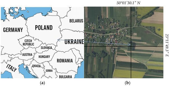
Figure 1.
Location of the study site—Żmijowiska, Podkarpackie Voivodeship, Poland (50°01′30.1″ N 23°11′49.3″ E): (a) location of the study area on the map of Europe, (b) detailed location of the studied building within the village of Żmijowiska.
Material, structure, and construction technique of the object: The church is wooden, built in a log construction using softwood placed on oak sill beams measuring up to 30 × 30 cm. The sacristy and the new part of the nave were appended to the old nave using post-and-bean construction. The building rests on granite boulders at the corners, with the spaces between the stones filled in with a brick foundation wall. The wall between the old and new parts of the nave was later cut through in the form of an arcade. The old part of the nave is covered by a pyramidal log dome, while the new part lacks a ceiling. The sanctuary is covered with a barrel vault. The sacristy has a flat ceiling at the upper level. The roofs follow a rafter–purlin structure, incorporating king-posts that support the substructure for the turrets and spires. The roof slopes and the domes of the turrets are covered with galvanized steel sheeting. In the lower parts of the corner joints of the old nave, sanctuary, and sacristy, there are exposed log ends and remnants of braces (rysie) that once supported a now-lost skirt roof (opasanie) removed before 1930. Board cladding with battens covers the walls of the old nave, sanctuary, and sacristy above the former skirt roof line, as well as the entire eastern wall of the sacristy. Plain board cladding (without battens) is used on the walls of the new nave and partially below the line of the former skirt roof on the southern walls of the old nave and sanctuary. Rectangular doorway openings are present in the external walls: the main portal is located in the west wall of the new nave, while a side entrance is placed in the north wall of the sanctuary. The iconostasis wall features openings for the royal doors and a pair of deacon’s doors. On the exterior of the main portal door, there is an iron knob bearing the initials and the year “HP 1881”; on the interior side, a lock is stamped with the year 1860. All windows are rectangular and framed: eight in the nave, two in the sanctuary, and one in the sacristy. The windows in the west wall of the nave were relocated from the narthex (babiniec), which was dismantled in 1930 [25,26].
The church in plan view is two-part, with the widest nave (comprising the old and new sections) and a narrower sanctuary with the sacristy aligned on its axis. From the west there are foundations of the porch (kruchta). All spaces are laid out in near-square plans except for the rectangular sacristy.
The church (Figure 2a,b) consists of two main volumes: a combined volume for the old and new sections of the nave and a smaller one for the sanctuary and sacristy, both covered with separate ridge roofs—the former with four slopes, the latter with three slopes. Positioned at the midpoint of the nave roof ridge is an octagonal tower topped with a bulbous (bania-shaped) dome and a cross mounted on a sphere. At the junction of the sanctuary and sacristy roof slopes rises a smaller tower with a similar arrangement.
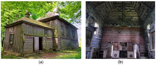
Figure 2.
Church of the Dormition of the Mother of God in Żmijowiska: (a) exterior view, (b) interior of the building.
Most of the furnishings were transported in 1969 to the Składnica Zabytków Ruchomych in Łańcut. Inside, there are two side altars, a prestoł, a mensa altaris (altar mensa), and small fragments of equipment. In the western part, relics of the choir loft remain. The walls of the old nave and sanctuary are covered with polychromy featuring architectural divisions in the lower sections and a star-studded sky on the vaults. The church is currently in poor condition. The walls of the old nave, sanctuary, and sacristy below the belt line have been exposed for decades to destructive atmospheric conditions. A significant portion of the log structure is infested by colonies of wood-boring insects. Despite its deteriorated condition, the monument remains an extremely valuable object for scientific research, as it consists almost entirely of original historic fabric [25,26].
Historical Background—State of Research on the Object and Description of Non-Geometric—Data Sources Across Different Periods of the Building’s History
The earliest references to a church in Żmijowiska date back to 1531 [27]. The currently existing church was built in 1770, as suggested by an inscription preserved on the northern wall of the priest’s section. Originally, it was a tripartite church consisting of a narthex, nave, and sanctuary. Some materials from an earlier structure were reused in its construction. In 1881, the church underwent renovation, the scope of which included the reconstruction of the vault over the sanctuary, the addition of a porch in front of the western entrance to the narthex, the widening of the western portal opening and installation of a new door wing in the main portal, covering the interior with polychromy, the construction of the sacristy, and the reconstruction of the skirt roof [25]. In 1930, the church was significantly expanded [28]. The original narthex was dismantled and replaced by an extension of the nave, to which a porch was added on the west side; the roof slopes were covered with metal sheets, the skirt roof was removed, and the external walls were boarded [25]. Since the late 1940s, following the displacement of the Ukrainian population, the church has remained out of use [26]. After 1944, the Border Protection Troops partially dismantled the porch, the ruins of which remained until the late 1950s [26,29]. The remains of its roof structure and the turret with dome are still located inside the church. In 1990, protective measures were undertaken: the sill beams, exposed log ends, and part of the unboarded wall structure were shielded with wooden shed roofs, and the foundation wall was supplemented.
The first known iconographic source of the object is a photograph taken by Stefan Wenhrynowycz between 1927 and 1930, showing the church from the northeast, prior to its expansion in 1930 [25]. In the 1950s, the church attracted the interest of conservation services. On 8 April 1956, Krzysztof Wolski took four photographs of the exterior elevations, and in June of the same year, Stefan Pągowski took three additional images, including one showing the iconostasis [30]. In 1959, S. Gumiński and B. Kleszczyńska completed the so-called green heritage register card, which included two photographs, a ground plan, and a brief inventory description [31]. The materials from the 1950s are the only known iconographic source showing the ruins of the now-lost porch, located along the western wall of the narthex. In 1961, staff of the newly established Repository of Movable Monuments at the Castle Museum in Łańcut conducted a descriptive inventory of the church, with special emphasis on its furnishings [32]. In 1965, Wacław Górski from the Photographic Studio of the State Enterprise for the Conservation of Monuments, Warsaw Branch, created a photographic documentation of the interior furnishings that were still present in the church at that time [33]. By the late 1960s, the church was included in the “Album of Church Structures in the Rzeszów Voivodeship” [34]. In 1969, part of the church furnishings, along with the already incomplete iconostasis, was transported to the Castle Museum in Łańcut [35]. In the 1960s, 70s, and 80s, valuable iconographic materials were produced by long-time heritage preservation specialists Jerzy Tur and Barbara Tondos [36]. In the 1980s, valuable information was also gathered by Wojciech Sobocki [26,29,36]. One of his most important findings was obtaining a sketch, architectural description, and postwar history of the now non-existent church bell tower—currently the most extensive source of information about this structure. In the 1990s, a second postwar generation of researchers of Eastern Church art, associated with the milieu of Jerzy Tur and Barbara Tondos, undertook work on documentation and a monographic study of the church in Żmijowiska. In July 1990, the Student Scientific Circle of General Construction at the Faculty of Architecture, Cracow University of Technology, under the supervision of Dr. Eng. Arch. Jan Kurek, organized a documentation and research camp during which the first comprehensive architectural survey and drawing documentation of the church was produced at a 1:50 scale [37]. In 1996, Eugeniusz Zawałeń, commissioned by the Regional Centre for Studies and Protection of the Cultural Environment in Rzeszów, conducted a detailed archival query in the records of the Greek Catholic Bishopric in Przemyśl at the State Archive in Przemyśl, concerning 14 churches from the Nadsanie region, including the church in Żmijowiska [38]. That same year, Jarosław Giemza prepared the so-called white heritage register card, containing a detailed architectural description, historical overview, and results of archival research of the Church Art Department of the Castle Museum in Łańcut [26]. A year later, Janusz Mazur completed his monumental master’s thesis “Wooden Churches in the Vicinity of Lubaczów,” which includes to date the most extensive monographic description of the church complex in Żmijowiska [39]. In 2013, the architectural firm M. Skwarek, J. Hulimka SP.J., commissioned by the ARTA Foundation and based on materials from the PWUOZ Archive in Przemyśl, developed a construction renovation project for the church, including a proposal for reconstructing the western porch and “restoring” the wooden shingle roofing of the building [40]. It should be noted here that chronological stratigraphy analysis definitively excluded the historical use of wooden shingles on the roof slopes of the church after its expansion in 1930 [25]. In July 2022, Andrzej Żygadło conducted a preliminary iconographic and architectural analysis of the monument in situ, along with chronological layer analysis, as part of work on the “Report on the Condition of Wooden Architecture in Poland” [25]. Between 2 and 5 May 2024, the Geodesy Student Scientific Circle of the University of Agriculture in Krakow, led by Dr. Eng. Przemysław Klapa and Dr. Hab. Eng. Bartosz Mitka, together with Andrzej Żygadło representing the K.W. Kielisiński Social Centre for Monument Documentation, conducted a documentation and research camp in Żmijowiska. During the fieldwork, point clouds, photographs for orthophotomaps, and direct measurements were collected to generate high-quality technical documentation, a detailed 3D model, and a realistic visualization of the church [41,42].
2.3. Reverse Chronology—Object Reconstruction
The reconstruction process was based on a reverse chronological approach, which involves analyzing the object’s history starting from the most recent state and progressively moving backward in time. This method is particularly effective in heritage studies, as it enables cross-verification of existing structures with prior documentation and facilitates identification of physical or functional transformations. It also supports incremental hypothesis building where earlier stages are interpreted in light of later, better-documented phases. The scope of analysis includes four selected temporal milestones, arranged in reverse chronological order: the current state (2024/2025), the condition of the building around 1990, its configuration circa 1930, and the original layout from approximately 1900. Each of these stages was reconstructed based on the most complete set of available source materials. These include Terrestrial Laser Scanning (TLS) point clouds for the present state, architectural documentation and photographic archives for the 1990s, technical records and historical archives for the 1930s, and constructional descriptions alongside period iconography for the turn of the 20th century. This temporal segmentation enabled a structured assessment of geometric transformations, constructional interventions, and material alterations over more than a century.
2.3.1. Inventory of the Current State (2024/2025)
Geometric Data
The basis for reconstructing the individual development phases of the object was a detailed inventory of its current state, conducted in 2024–2025. Data acquisition was based primarily on geometric data—most importantly, a dense, comprehensive, and high-resolution point cloud obtained through terrestrial laser scanning (TLS). Measurements were carried out using a multi-station method with a Leica ScanStation P40 laser scanner (Heerbrugg, Switzerland) (Figure 3a,c), which enabled full coverage of all elevations (Figure 3b), the roof, and the building’s interior (Figure 3d). The resulting point cloud allowed for a detailed representation of the architectural and spatial structure of the entire object. The building’s condition and geometric form were also recorded using photogrammetric techniques. Photographs taken during the survey were used both to validate the TLS data and to supplement information on architectural details, textures, and surface conditions. Additionally, the photographs enabled visual analysis of deformations, damage, and material transformations that are not visible in the point cloud itself.
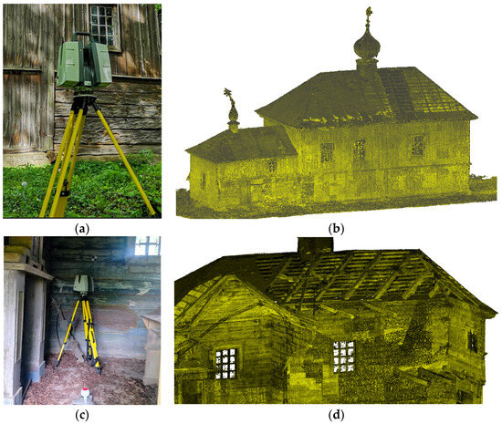
Figure 3.
Point cloud acquisition for the object: (a) Leica P40 scanner, (b) point cloud—exterior of the building, (c) interior scanning, (d) point cloud cross-section—interior part of view of structural elements.
The model created using HBIM technology is not only a representation of the building’s geometry but, above all, a structure containing descriptive information that assigns meaning to the model’s elements and enables their interpretation in historical, material, and functional contexts. A key aspect of the modeling process was the assignment of non-geometric attributes to BIM components—such as object types, materials, functions, or structural affiliation. The basis for identifying and supplementing non-geometric information for individual building elements was semantic source material. An important role was also played by the results of the on-site inspection, which allowed for the identification of construction materials, spatial arrangement, and current technical condition (Figure 4b). Supplementary information came from iconographic documentation (Figure 4c,d), which enabled visual analysis of details and verification of data contained in archival documents.
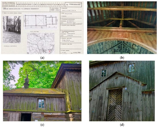
Figure 4.
Sources of non-geometric data: (a) Excerpt from the Monument Inventory Card [26], (b) structural components of the building, (c) decorative and finishing elements, (d) window and door joinery.
Object Modeling—HBIM Generation
Based on the geometric data obtained from terrestrial laser scanning and the aforementioned non-geometric information, a complete representation of the analyzed structure was created within the BIM environment (Figure 5). The modeling covered all architectural elements visible in the point cloud, as well as those identified through the analysis of archival materials, technical documentation, and photographs. Each model component was assigned to the appropriate family and object type, according to its function, material, structural affiliation, and preserved historical features. This process was based on prior identification and classification of elements using non-geometric data such as architectural descriptions, field observations, and information on construction techniques used. The model was developed using Autodesk Revit 2024 software, which allows for the creation of parametric 3D objects and the assignment of semantic attributes. Through the integration of geometric and descriptive data, a coherent model was obtained, serving as a basis for further analysis of changes and reconstruction of earlier phases of the object’s existence.
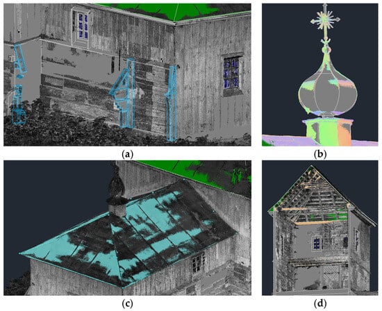
Figure 5.
3D Modeling in BIM technology: (a) walls and structural components, (b) decorative elements—tower, (c) roof, (d) obstructive roof elements.
2.3.2. Reconstruction of the Building’s Condition in the 1990s
Collected Materials Documenting the State of the Object
The year 1990 marks a key moment in the history of documentation and research on the church in Żmijowiska, due to the completion of its first comprehensive architectural and surveying inventory. In July of that year, during a scientific camp organized by the Student Scientific Circle of General Construction at the Faculty of Architecture of the Cracow University of Technology, under the supervision of Dr. Eng. Arch. Jan Kurek, detailed drawing and descriptive documentation was produced at a 1:50 scale (Figure 6) [37]. This was the first such precise survey of the building, covering both its spatial structure and architectural details, as well as its condition. Six years later, Jarosław Giemza prepared the Heritage Register Card for the church [26], including information on its history, construction, materials, and technical condition, as well as photographs showing the building’s appearance in the mid-1980s. Although some of the information presented therein has become outdated in light of recent research, it remains a highly valuable contribution to the monument’s history. The HBIM model reconstruction in the version corresponding to the state of the building in 1990 was largely based on the above-mentioned documentation. Graphic data (plans, sections, elevations), technical descriptions, and photographic material (Figure 7) enabled accurate reconstruction of the building’s geometry prior to the modernization and preservation measures carried out in 1990–1991. Based on these materials, the volume layout, structural divisions, and basic material characteristics were modeled, preserving the characteristic proportions and architectural detail.
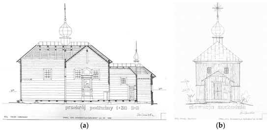
Figure 6.
Technical documentation: (a) building cross-section, (b) elevation drawing; source: [37].
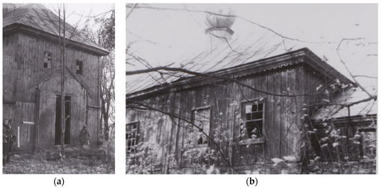
Figure 7.
Photographic documentation of the object: (a) main entrance—west elevation, (b) nave and part of the narthex; source: [26].
A comparison of the 1990 documentation with the current 3D model revealed a number of changes introduced shortly after the inventory was completed. Among the most significant conservation interventions was the installation of wooden shed roofs protecting the braces, exposed log ends, selected wall structure areas, and sill beams. On the western elevation, a board covering was added, integrated into the negative space left by the now-lost porch. In the eastern window of the southern wall of the old part of the nave, a new window wing was installed, and parts of the foundation wall were supplemented. Inside the building, missing floorboards under the choir loft were replaced, and along the entire length of the sill beam, a horizontal bitumen felt insulation was applied to prevent capillary moisture rise. Additionally, missing panes in some window casements were replaced or supplemented, and the sheet metal roofing was conserved by repairing gaps and damage.
The geometric reconstruction for the year 1990 (Figure 8) reflects the condition of the building prior to the aforementioned interventions, allowing for their clear identification and distinction within the HBIM model. This stage also provides a reference point for further reconstruction of earlier phases in the church’s existence, including its state before the Second World War [25,26].
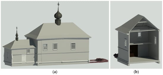
Figure 8.
Reconstruction of the geometric form of the church based on the 1990 technical documentation, supported by descriptive records and iconographic sources compiled after the conservation works: (a) presentation of the entire object; (b) cross-section through the object.
2.3.3. Reconstruction of the Building’s Condition in the 1930s
In 1930, the church underwent a major reconstruction, the main objective of which was to increase its volume and adapt it to the functional and aesthetic requirements of the time. The old narthex was dismantled, and a large opening was cut into the western wall of the nave. The roof over the nave dome and the skirt roof surrounding the church were also dismantled, leaving behind remnants of the latter in the form of braces on the northern wall of the sanctuary and the northeast corner joint of the nave walls. The wooden shingle roofing on the remaining roofs of the building was removed. The nave was extended westward, incorporating remnants of the old narthex into its structure, such as a door, a side window with grilles, a few old beams, and two boulders from the original foundation, which were placed beneath the corner joints. The enlarged nave body was covered with a new hipped roof crowned by an octagonal tower with a dome, sphere, and cross. A new cornice was installed beneath the eaves of the new part of the nave, while the original cornice was preserved on the older section. In front of the western entrance, a log-frame porch was added, built partly from material salvaged from the dismantled narthex. The roofs were clad with galvanized steel sheets. The walls of the newly built parts of the church, as well as the lower sections of the older walls beneath the removed skirt roof, were covered with plain boarding without battens. Between the granite boulders forming the original foundation, a brick underpinning was added and plastered on the face. A similar underpinning was also constructed for the porch, including a three-step staircase spanning the entire width of the building on the western side [25].
The geometric reconstruction of the church as it appeared in the 1930s was carried out based on preserved archival information, construction traces visible in the building’s structure, and descriptive materials contained in historical documentation [25,30,31]. Of particular importance were the traces of the dismantled porch roof and the remains of its foundations (Figure 9), the presence of which made it possible to determine the original extent and configuration of the volume. A crucial stage of the process was the in situ architectural investigation, during which it was found, among other things, that the northeastern corner of the nave contained nails from now-lost boarding, as well as remnants of braces removed during surface preparation for cladding. Fragments of boarding without battens were preserved on the north wall of the nave and sanctuary. On the corner joints of the sacristy, traces of battens fitted to the shape of log ends and braces were discovered, indicating their earlier protective function. The spaces between the granite boulders forming the foundation had been secondarily filled with a brick underpinning faced with mineral mortar. The same construction technique—typical of the 1930s—was used for the foundations of the new section of the nave, as well as the foundations and steps in front of the porch entrance. The lower parts of the southern walls of the nave, sacristy, and sanctuary were, like those on the north elevation, protected with plain boarding and an overhanging skirt roof, as evidenced by a row of nail holes along the seventh log of the sanctuary wall [25]. The poor condition of the braces and corner joints on the southern elevation of the nave and sanctuary, already noted in 1956, suggests that they were either not protected in 1930 or that the protective elements were damaged or destroyed prior to 1956. As for the apron protecting the sill beam, there is no certainty regarding its presence—except for the eastern wall of the sacristy and the side walls of the porch, where preserved traces visible in iconographic materials confirm the existence of such a solution. However, it remains unclear whether it was a shingle-covered element or one made of boards [30].
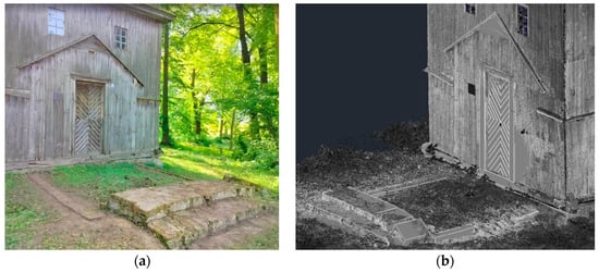
Figure 9.
Traces on the structure—remnants of earlier construction phases: (a) photographic evidence of structural changes, (b) point cloud—geometry of architectural elements.
Porch Reconstruction
The reconstruction of the porch’s volume and structure was based on a multi-source analysis of geometric and archival materials. A critical role was played by the point cloud obtained from a contemporary TLS inventory, which enabled the recording of preserved remnants of the foundation beam and geometric traces on the west façade—allowing precise determination of the location, shape, and dimensions of the now-lost porch (Figure 9). The collected data were complemented by descriptive documentation and archival photographs from the 1950s (Figure 10). The porch was situated on the axis of the church, attached by a post to the western wall of the nave. Its log walls were erected atop a brick, plastered plinth, integrally connected with three-tiered steps to the west mirroring the wall’s width. On the south and north sides, the foundation beam was protected by a wooden skirt. The remnants of the western foundation beam were cut diagonally to accommodate this skirt. The external surfaces of the walls were most likely covered with boarding without molding, similar to other boarded areas in 1930. The porch was topped by a roof featuring a rafter-purlin framework. At the intersection of the roof slopes, a small tower with a helmet-shaped roof, ball, and cross was mounted—supported on a king post bearing on the purlins. The roof slopes were covered with sheet metal, consistent with the rest of the building [25,26,30,31].
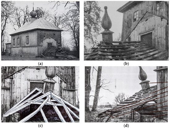
Figure 10.
Archival photographic documentation of the collapsed porch: (a) frontal view, (b) side view; source: [31], (c) reconstruction of the roof truss based on the photograph, (d) reconstruction and identification of structural elements based on the photograph [25,30].
A rectangular portal, located on the axis of the west façade, had a tripartite-arched lintel and was closed by double-leaf plank doors reinforced with battens and iron strap hinges. Inside, the porch featured a floor made of tongue-and-groove boards fastened to joists running east–west. The porch plan was nearly square, and its volume took the form of a compact cuboid covered by a three-sloped gable roof topped by a spired turret. Remnants of the porch’s roof frame and the mentioned turret—crowned the narthex before 1930—have survived within the interior of the church to this day. The preserved parts of the porch, together with iconographic materials, served to reconstruct its geometry and structural arrangement. Especially valuable iconographic sources supporting the porch reconstruction were archival photographs from the 1950s, taken during the first inventory efforts (Figure 11) [30,31].
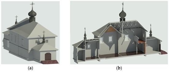
Figure 11.
Reconstructed model of the church as of ca. 1930: (a) front view of the structure, (b) cross-section through the building’s volume.
2.3.4. Reconstruction of the Church’s Condition from the Late 19th Century
The reconstruction of the church in Żmijowiska as it appeared in 1881, like in the previous cases, was based on a multi-source analysis. Key to the interpretation of this phase were data concerning the major renovation of the church carried out in 1881, which included the reconstruction of the sanctuary vaults, construction of the sacristy, addition of a porch at the western entrance, widening of the western portal opening, installation of new doors, and a change in the pitch of the skirt roof [25]. As a result of these interventions, the building’s form was transformed, acquiring characteristic functional and aesthetic features typical of the late 19th century. An important tool for supplementing knowledge about the western elevation—particularly its parts not visible in iconographic sources—was a stylistic and comparative analysis with the historic church in Wólka Żmijowska, erected or rebuilt in 1894 and located near Żmijowiska. This analysis is justified by the shared history of both churches, which belonged to the same parish, and their formal analogies—particularly the original layout of the sacristy aligned on the central axis behind the sanctuary [25,26,31].
The most important source enabling verification and supplementation of the data is a photograph taken by S. Wenhrynowycz between 1927 and 1930 (Figure 12), showing the church from the northeast before its reconstruction in 1930. This image provides numerous details about the form of the building, including the skirt roof, the turret with a dome above the nave, the architecture of the now-lost narthex with a vestibule, the roofing materials used at the time, and the window joinery. One of its most significant contributions is the ability to clarify the chronology of renovations undertaken at the end of the 19th and the beginning of the 20th century—a timeline otherwise obscured by the secondary reuse of 19th-century, date-bearing architectural elements in the new nave constructed in 1930.
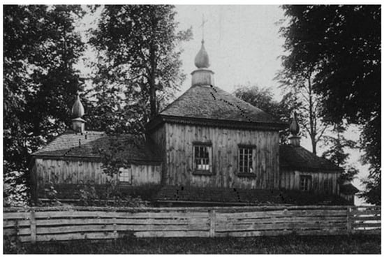
Figure 12.
Żmijowiska. Church of the Dormition of the Mother of God. View from the northeast, captured before the renovation works carried out in 1930. Photo by S. Wenhrynowycz, 1927–1930.
This photograph (Figure 12) clearly confirms the existence of a roofed entrance preceding the porch on the western side—an element that is no longer visible in later documentation, yet essential for understanding the composition of the church’s entrance. The image also provides valuable insights into the form of the roof covering, the arrangement of openings, and the characteristics of the window joinery. By comparing the geometric data with constructional relics and historical source materials, it was possible to reconstruct the functional layout and architectural form of the church as it appeared at the end of the 19th and the beginning of the 20th century. The outcome of this work was a digital reconstruction of the building at this stage of its development (Figure 13), which serves as a basis for comparisons with subsequent phases of transformation.
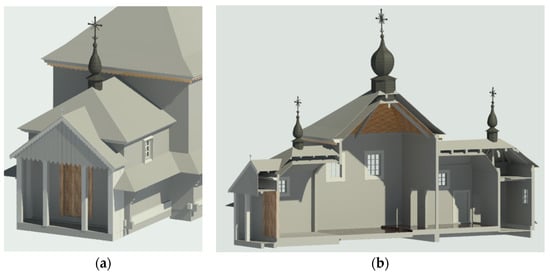
Figure 13.
Reconstruction of the building’s condition at the turn of the 19th and 20th centuries: (a) view of the front elevation, (b) cross-section through the building’s structure.
3. Results
As a result of the conducted analysis and multi-stage reconstruction, four geometric models of the building were developed (Figure 14, Figure 15, Figure 16 and Figure 17), corresponding to its state in four key periods: the contemporary condition (2024/2025), 1990, the interwar period (ca. 1930), and the turn of the 19th and 20th centuries (ca. 1881–1930). For each of these stages, the architectural form of the church was recreated based on available geometric data (point clouds, technical documentation, and direct measurements) and non-geometric information (architectural descriptions, photographs, and historical analyses). The reconstruction enabled an in-depth analysis of geometric changes, including transformations of the main building volume, architectural details, roof structure, window and door arrangements, as well as the configuration of the entrance zone. The models were compared in terms of spatial layout, relationships between structural elements, and dimensions of the building’s main components. Based on this comparison, key phases in the development and transformation of the church were identified, accounting for conservation interventions, adaptive modifications, and degradation processes that occurred over the span of more than 100 years.
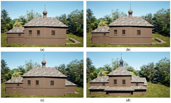
Figure 14.
Overall Massing of the Object: (a) 2024, (b) 1990, (c) 1930, (d) 1881.
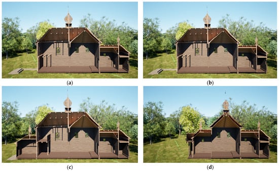
Figure 15.
Cross-section through the building mass: (a) 2024, (b) 1990, (c) 1930, (d) 1881.
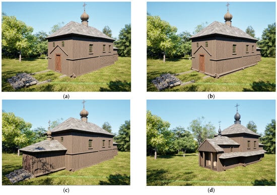
Figure 16.
View of the front elevation: (a) 2024, (b) 1990, (c) 1930, (d) 1881.
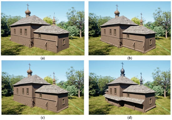
Figure 17.
View of the church from the sacristy side: (a) 2024, (b) 1990, (c) 1930, (d) 1881.
Comparative analysis of four temporal models of the Church in Żmijowiska—corresponding to the years 2024/2025, 1990, 1930, and the turn of the 19th and 20th centuries (1881–1900)—enabled detailed identification of key geometric transformations and the spatial evolution of the building’s form. The models differ both in terms of construction details and the overall composition of the massing, reflecting successive stages of adaptation, renovation, and ongoing material degradation. The comparison was based on 3D model analysis, section comparisons, control points, and relational measurements of selected components. The most significant transformations were identified in the western part of the building—primarily affecting the porch and front elevation. Originally constructed as a simple log structure, the porch was rebuilt in the 1930s and enhanced with additional elements such as a roof with a turret, protective skirts, and stairs. After its later dismantling, traces of its former structure remained only as foundation relics and geometric deformations recorded in the point cloud. The model representing the 1990 condition revealed numerous changes related to protective interventions—including the installation of wooden skirts shielding the log walls, protective eaves, and replacement of windows and doors. The current geometry of the building is simplified compared to its condition from a century ago, both in form and in the number of architectural details. This simplification results from material losses and the streamlined methods used in subsequent conservation efforts. The identified differences are of key importance for future conservation work, reconstruction planning, and the documentation of structural changes.
As part of the reconstruction process, a systematic evaluation of all data sources was carried out to assess their usefulness in faithfully representing the historical object. It should be emphasized that Table 1 below does not refer solely to spatial precision or positional accuracy, but rather to the overall level of trust with which each source allows the actual appearance, form, and structural character of the object to be reconstructed. Table 1 takes into account both the informational value of the materials in modeling shape, proportions, and architectural details, as well as their interpretive potential in the historical and descriptive context.

Table 1.
Comparative assessment of data sources used in the reconstruction process with respect to metric accuracy and interpretive reliability.
The metric accuracy of the data sources utilized varies significantly based on measurement technology and the precision of historical documentation. Terrestrial Laser Scanning (TLS) offers the highest accuracy (2–5 mm), forming a robust geometric baseline. Close-range photogrammetry with ground control points achieves centimeter-level precision (2–3 cm) and provides valuable semantic details. Historical technical documentation typically enables accuracy within several centimeters (~5 cm). Archival photographs alone yield lower geometric fidelity (~10–20 cm), but accuracy can improve significantly (~5–15 cm) when integrated with precise geometric references. Historical descriptions and records allow approximate decimeter-level (~10 cm) accuracy, while purely descriptive sources and stylistic comparisons remain broadly indicative, with precision in the order of tens of centimeters.
To verify the geometric accuracy and semantic consistency of the developed models, validation was conducted through comparisons with a reference model derived from the TLS point cloud, detailed records found in historical technical documentation, and—most importantly—through meticulous analysis conducted directly on-site. Crucial to this verification process were the tangible physical remnants still present on the object, such as fragments of ruins and structural relics, traces of missing architectural elements, distinctive carpentry marks, incisions, and impressions that revealed the original spatial layout and construction details. Comparing the models against these authentic physical indicators confirmed a high degree of geometric precision and validated the semantic interpretations concerning the chronological and stylistic phases in the historical evolution of the studied heritage object.
4. Discussion
The collected data confirm that documentation, analysis, and reconstruction of historic buildings represent key challenges in the process of cultural heritage preservation. These structures, subjected to numerous interventions and natural deterioration, require an interdisciplinary approach that integrates geometric data—such as point clouds from TLS or photogrammetric models—with non-geometric information, including archival photographs, technical records, conservation documentation, and entries from heritage registers. Only the integration of these diverse sources enables a credible reconstruction of a building’s earlier phases. In this context, the use of HBIM platforms and technologies supports not only the creation of accurate 3D metric models but also their enrichment with semantic and historical components. In an HBIM model, individual elements can be assigned to specific historical phases, which significantly facilitates the analysis of transformation processes. HBIM thus gains the status of a heritage management tool, enabling digital documentation, change analysis, and the design of conservation scenarios [1,10,43]. Archival data—such as photographs, heritage register entries, historical documentation, and descriptive records—prove particularly valuable. In our case, photographs taken by Stefan Pągowski, Krzysztof Wolski, and other conservators in the mid-20th century serve as unique iconographic sources that depict, for example, the ruined porch or original cladding, no longer preserved today. Their integration with modern scanning and photogrammetry techniques enabled the digital reconstruction of lost architectural elements. Without the photograph taken by S. Wenhrynowycz between 1927 and 1930, it would not have been possible to reconstruct the geometry or form of the church prior to the major renovation undertaken in 1930. This approach—combining historical data with 3D modeling technologies—results in the creation of three-dimensional reconstructions of the building in various phases of its existence [44].
The developed HBIM models achieved a very high level of detail in terms of both geometry and semantic information. These models are based on integrated data acquired through terrestrial laser scanning (TLS), photogrammetry, as well as technical and photographic documentation, enabling the precise representation of the building’s complex architecture and detailed semantic annotations. The models correspond to the Level of Detail (LOD) and the Level of Information (LOI) standards. From a geometric standpoint, the models closely match LOD 4 (equivalent to LOD 350 according to BIM specifications), meaning that the primary components of the structure are represented virtually in their as-built state [45]. Such a level of detail also aligns with the CityGML LoD4 classification, encompassing detailed modeling of both the exterior and interior of the heritage structure [46]. However, it is important to emphasize that not all components require maximum detailing—exceptionally irregular elements were represented through simplified geometry or directly as surface meshes generated from point clouds, which is a recommended practice in modeling historical changes in heritage structures [47]. The variation in detail levels within a single model aligns with best practices in HBIM, often resulting from incomplete or fragmentary information about certain elements of the reconstructed object. In such cases, modeling at a lower level of detail is a justified solution, allowing for maintaining scientific integrity and interpretative accuracy. In terms of semantic detail, the models exhibit an equally high level—each component was attributed information mainly concerning materials, colors, and structural characteristics, enhancing the LOI and transforming the models into comprehensive repositories of knowledge, encompassing not only geometric data but also the semantic details of their individual components [45,48]. Practically, this means that any local reduction in geometric detail (such as substituting minor components with surface meshes) is effectively compensated by the high level of descriptive information. Additionally, the models incorporate a temporal component illustrating the changes in the building over nearly 150 years (4D BIM), surpassing traditional static LOD scales. This historical dimension corresponds to the concept of Level of History (LoH) proposed in HBIM literature, enabling detailed chronological analyses of the building’s state of preservation and transformations [47]. Therefore, the overall detail level of the developed models can be assessed as LOD 4 (LOD 350) for major structural and architectural elements, with a lower level of detail applied solely to selected, heavily degraded components such as roofing elements. Such a high level of detail was achievable due to the quality and diversity of source data and measurement techniques. Research indicates that the achievable detail accuracy of 3D models is directly dependent on the density and quality of point clouds, photographic, and architectural documentation used in the HBIM process, as well as the comprehensiveness and precision of historical and architectural descriptions [47].
Effective reconstruction of heritage buildings requires an integrated approach that combines both geometric and non-geometric data. Only such hybrid methodology—based on precise measurements as well as descriptive, semantic, and iconographic sources—enables the creation of reliable models reflecting the architectural evolution of a structure over the decades. HBIM models, enriched with contextual data, serve not only as geometric carriers but also as platforms for analyzing transformations, making conservation decisions, and forecasting future changes. The use of TLS has proven particularly effective in capturing the current state of the building, providing high-density and high-accuracy data essential for modeling complex structures and architectural details. The resulting point cloud not only facilitates the creation of a faithful reference model but also serves as a benchmark for analyzing deformations, displacements, and material degradation [15]. Within the scan-to-HBIM workflow, TLS data formed the primary geometric base, and its integration with archival sources enabled the digital reconstruction of earlier stages of the church’s existence. Non-geometric data—such as technical descriptions, heritage inventory cards, iconography, and historical analyses—played a vital role in this process. Their combination with 3D models enabled the recreation of non-existent or distorted elements and the identification of original architectural solutions. Archival photographs, despite their limited quality, proved invaluable—particularly in the reconstruction of the now-lost porch. The integration of such photographs with point cloud data allowed for the accurate spatial placement of elements and the analysis of their transformations. This practice—also validated in the work of Maiwald et al. (2018) [44]—emphasizes the growing role of visual data in the digital reconstruction of historic structures. Of particular value in the reconstruction process is the methodology of reverse chronology, which involves analyzing the building’s successive transformations by tracing them backward from the current state to the original. This approach enhances the understanding of spatial change logic and the gradual evolution of architectural layouts. Furthermore, these findings confirm that even with limited geometric data, it is possible to reconstruct a structure based on semantic, historical, and material information—significantly broadening the applicability of HBIM in heritage reconstruction [14]. Finally, the interdisciplinary nature of the methodology—combining expertise from architecture, art history, engineering, and digital technologies—not only enhances understanding of the examined object but also facilitates the transfer of developed solutions to other cases of similar character. This strategy allows for the creation of scalable reconstruction models that can be applied in both local heritage documentation and broader cultural landscape management systems [10,49]. Recent studies further highlight the importance of a multi-source data-driven approach. An integrated HBIM model can effectively support the analysis of architectural changes over time. In related research, TLS data, architectural documentation, and iconographic materials have been successfully used for the digital reconstruction of historical structures across different development stages (Chelaru et al., 2024) [19]. Particularly effective is the synergy of data from various surveying techniques—such as TLS, UAV photogrammetry, MMS, and traditional photogrammetry—which significantly enhances the accuracy and completeness of models, as confirmed by the works of Chiabrando et al. (2019) [23] and Castilla et al. (2021) [50]. Despite its considerable potential, HBIM technology still faces several limitations—such as the lack of full interoperability between platforms, challenges in modeling irregular forms, and in the absence of standardized semantics for heritage objects [49]. Nevertheless, its ability to integrate various types of data—geometric, material, and descriptive—makes it a key tool in contemporary heritage conservation. This potential is further enhanced by its integration with 4D analysis tools and augmented reality environments, which enable not only thorough documentation but also interactive interpretation of spatial changes over time.
5. Conclusions
The results of the digital reconstruction project of the church in Żmijowiska confirm the critical importance of 3D methodologies based on HBIM and the fusion of multi-source data. The integrated use of TLS, photogrammetry, available architectural documentation, archival photographs, and heritage inventory records enabled a comprehensive reconstruction of the building’s historical development phases, as well as a detailed analysis of changes in its spatial form across decades. This holistic approach made it possible to identify, for example, the impact of the major 1881 renovation (including the addition of a new vestibule and porch) and the 1930 restoration on the building’s volume and structure—insights that would be difficult to obtain using traditional 3D modeling methods based solely on limited datasets. The HBIM model integrates precise geometric data (point clouds, photogrammetric models) with descriptive information (e.g., materials, condition, historical transformation phases), offering a significant advantage over conventional purely geometric modeling that lacks semantic layers. The Żmijowiska case demonstrates that combining geometric and non-geometric data within a coherent digital model is an effective method for documenting and reconstructing heritage buildings—enabling not only accurate representation of their current condition but also digital reconstructions of their historical stages.
The multi-source HBIM model of the church serves a wide range of practical applications—from supporting conservation planning and maintenance strategies, through comparative analyses (e.g., assessments of geometric changes), to education and the dissemination of heritage knowledge via virtual reconstructions and public access to rich informational content. It is worth emphasizing that HBIM technology, when integrated with data obtained through terrestrial laser scanning, provides an effective tool for documenting and analyzing cultural heritage sites. It enables not only the precise representation of a building’s current geometry but also systematic tracking of transformations over time. Modeling based on TLS data ensures high-resolution and geometric accuracy, which is particularly valuable for analyzing architectural details, deformations, or structural damage. The integration of geometric data with semantic, topological, and descriptive information enables a more comprehensive understanding of the building’s history and its transformations—especially in cases where complete metric documentation is lacking. The incorporation of non-geometric data—such as architectural documentation, archival photographs, conservation records, and field observations—makes it possible to develop models with greater analytical and conservation value.
BIM offers a significant advantage over traditional 3D modeling approaches. Unlike models focused solely on geometry, HBIM allows for the assignment of information to model elements regarding materials, historical transformations, technical condition, and spatial function. This enriched data structure enables integration with maintenance management systems, GIS databases, and heritage documentation repositories, making HBIM a powerful tool for long-term heritage management. However, the implementation of BIM in the context of historical reconstruction comes with certain challenges, including incomplete archival documentation, architectural complexity, and difficulties in modeling irregular elements. Nevertheless, an approach based on multi-source data integration, comparative analysis, and phased modeling enables the creation of reliable and information-rich digital models—even when source data are limited. The use of reverse chronology, critical analysis of iconographic materials, and identification of physical traces within the structure serve as effective tools supporting the entire reconstruction process. In light of the growing importance of cultural heritage digitization, HBIM—as a platform that integrates technical, architectural, and historical knowledge—continues to strengthen its position as a key tool in the study, conservation, and dissemination of historical architecture.
The proposed methodology represents a modern approach to presenting and documenting architectural heritage, creating simultaneously a digital knowledge repository of cultural heritage objects, encompassing both their current state of preservation and reconstructed forms from past periods. Based on the conducted case study, we demonstrated the possibility of utilizing various data sources in the digital reconstruction of historical objects. Through integrating data from terrestrial laser scanning (TLS), photogrammetry, archival photographs, historical records, and detailed measurements, this methodology provides a versatile tool for generating HBIM models, realistic visualizations, and credible historical reconstructions. It is crucial to emphasize that while the overall methodological framework is universally applicable, each heritage object requires an individual approach, considering the availability and quality of source materials. The scope and detail of the reconstruction process are significantly influenced by archival resources, including technical drawings, photographs, historical descriptions, narratives, and other documentary records, as well as by the state of preservation of the heritage object itself. It is also crucial to emphasize that digital reconstruction constitutes a dynamic and open-ended process. New discoveries, ongoing historical research, or previously unknown archival materials can continuously provide additional insights, resolve historical ambiguities, and clarify both the original appearance and the functional characteristics of reconstructed heritage objects. Moreover, newly acquired materials enable the reconstruction of earlier, previously unknown forms of these objects, thus substantially contributing to the advancement of knowledge regarding cultural heritage. Nevertheless, despite the universal applicability of the proposed methodology, it is essential to remember that each cultural heritage object is unique and demands an individualized approach, carefully considering the availability and quality of source materials. Another inherent limitation of the method is its direct dependence on the state of preservation of the object and the availability of archival data, which can often be incomplete, fragmentary, or entirely absent. In such situations, the reconstruction process must rely on approximations and analogies, potentially influencing the precision with which certain architectural details are represented.
The resulting digital BIM models of reconstructed heritage sites offer a broad spectrum of applications. They can serve institutions dedicated to heritage preservation, such as museums, the National Heritage Board, or regional monument preservation offices, as a tool supporting conservation practices, analytical tasks, and planning potential reconstructions. Furthermore, these models hold exceptional value for educational purposes and public outreach. They can be publicly showcased on digital platforms, through virtual museums or interactive applications, providing users with visual and immersive experiences of historical structures. This form of presenting cultural heritage fosters greater public historical awareness and disseminates knowledge in the fields of HBIM technology, 3D modeling, and advanced visualization techniques for historical architecture. The conducted research also opens up possibilities for further development and refinement of the presented methodology. Promising directions for future research include advanced image-processing techniques based on artificial intelligence (AI), partial automation of the HBIM model creation process, and exploring the scalability of the approach to other types of historical architectural objects. Pursuing these directions will further enhance the efficiency, accuracy, and versatility of the methodology, significantly broadening its practical application in the field of cultural heritage preservation.
Author Contributions
Conceptualization, P.K., A.Ż. and M.P.; methodology, P.K., A.Ż. and M.P.; software, P.K. and A.Ż.; validation, P.K. and A.Ż.; formal analysis, P.K. and A.Ż.; investigation, P.K. and A.Ż.; resources, P.K. and A.Ż.; data curation, P.K. and A.Ż.; writing—original draft preparation, P.K., A.Ż. and M.P.; writing—review and editing, P.K., A.Ż. and M.P.; visualization, P.K.; supervision, P.K., A.Ż. and M.P.; project administration, PK. All authors have read and agreed to the published version of the manuscript.
Funding
This research was funded by the Polish Ministry of Education and Science from a subsidy for the University of Agriculture in Krakow (Department of Geodesy).
Institutional Review Board Statement
Not applicable.
Informed Consent Statement
Not applicable.
Data Availability Statement
The research data, materials, and other datasets collected and used in this article are available from the corresponding author upon reasonable request. Access may be granted upon presentation of a justified rationale and intended purpose for their use.
Acknowledgments
The authors would like to express their sincere appreciation to Jarosław Giemza, for generously providing invaluable research materials. The authors also wish to extend their heartfelt thanks to Jan Kurek for granting access to essential research resources and technical documentation.
Conflicts of Interest
The authors declare no conflicts of interest.
References and Notes
- Kamaruzaman, N.U.S.N. Historic Building Information Modelling (HBIM): A Review. In European Proceedings of Multidisciplinary Sciences, EpMS, Proceedings of the 4th International Conference on Rebuilding Place; Future Academy: Singapore, 2019; pp. 588–593. [Google Scholar] [CrossRef]
- Pepe, M.; Alfio, V.S.; Costantino, D. UAV Platforms and the SfM-MVS Approach in the 3D Surveys and Modelling: A Review in the Cultural Heritage Field. Appl. Sci. 2022, 12, 12886. [Google Scholar] [CrossRef]
- Calka, B.; Jaczewska, P.; Słowik, J. Integration of Multi-Source Archival Data for 3D Reconstruction of Non-Existent Historical Buildings. Appl. Sci. 2025, 15, 299. [Google Scholar] [CrossRef]
- Li, W.; Yang, H.; Hu, Z.; Zheng, J.; Xia, G.-S.; He, C. 3D Building Reconstruction from Monocular Remote Sensing Images with Multi-Level Supervisions. arXiv 2024, arXiv:2404.04823. [Google Scholar] [CrossRef]
- Guarnieri, A.; Fissore, F.; Masiero, A.; Vettore, A. From TLS Survey to 3D Solid Modeling for Documentation of Built Heritage: The Case Study of Porta Savonarola in Padua. Int. Arch. Photogramm. Remote Sens. Spat. Inf. Sci. 2017, XLII-2/W5, 303–308. [Google Scholar] [CrossRef]
- Moyano, J.; Carreño, E.; Nieto-Julián, J.E.; Gil-Arizón, I.; Bruno, S. Systematic Approach to Generate Historical Building Information Modelling (HBIM) in Architectural Restoration Project. Autom. Constr. 2022, 143, 104551. [Google Scholar] [CrossRef]
- Klapa, P. Standardisation in 3D Building Modelling: Terrestrial and Mobile Laser Scanning Level of Detail. Adv. Sci. Technol. Res. J. 2025, 19, 238–251. [Google Scholar] [CrossRef]
- Pepe, M.; Costantino, D.; Restuccia Garofalo, A. An Efficient Pipeline to Obtain 3D Model for HBIM and Structural Analysis Purposes from 3D Point Clouds. Appl. Sci. 2020, 10, 1235. [Google Scholar] [CrossRef]
- Lin, G.; Li, G.; Giordano, A.; Sang, K.; Stendardo, L.; Yang, X. Three-Dimensional Documentation and Reconversion of Architectural Heritage by UAV and HBIM: A Study of Santo Stefano Church in Italy. Drones 2024, 8, 250. [Google Scholar] [CrossRef]
- López, F.J.; Lerones, P.M.; Llamas, J.; Gómez-García-Bermejo, J.; Zalama, E. A Review of Heritage Building Information Modeling (H-BIM). Multimodal Technol. Interact. 2018, 2, 21. [Google Scholar] [CrossRef]
- Karataş, L.; Alptekin, A.; Yakar, M. Creating Architectural Surveys of Traditional Buildings with the Help of Terrestrial Laser Scanning Method (TLS) and Orthophotos: Historical Diyarbakır Sur Mansion. Adv. LiDAR 2022, 2, 54–63. [Google Scholar] [CrossRef]
- Rocha, G.; Mateus, L.; Fernández, J.; Ferreira, V. A Scan-to-BIM Methodology Applied to Heritage Buildings. Heritage 2020, 3, 47–67. [Google Scholar] [CrossRef]
- Klapa, P.; Gawronek, P. Synergy of Geospatial Data from TLS and UAV for Heritage Building Information Modeling (HBIM). Remote Sens. 2023, 15, 128. [Google Scholar] [CrossRef]
- Pepe, M.; Costantino, D.; Alfio, V.S.; Restuccia Garofalo, A.; Papalino, N.M. Scan to BIM for the Digital Management and Representation in 3D GIS Environment of Cultural Heritage Site. J. Cult. Herit. 2021, 50, 115–125. [Google Scholar] [CrossRef]
- Rocha, G.; Mateus, L.; Ferreira, V. Historical Heritage Maintenance via Scan-to-BIM Approaches: A Case Study of the Lisbon Agricultural Exhibition Pavilion. ISPRS Int. J. Geo-Inf. 2024, 13, 54. [Google Scholar] [CrossRef]
- Patrucco, G.; Gómez, A.; Adineh, A.; Rahrig, M.; Lerma, J.L. 3D Data Fusion for Historical Analyses of Heritage Buildings Using Thermal Images: The Palacio de Colomina as a Case Study. Remote Sens. 2022, 14, 5699. [Google Scholar] [CrossRef]
- Tsilimantou, E.; Delegou, E.T.; Nikitakos, I.A.; Ioannidis, C.; Moropoulou, A. GIS and BIM as Integrated Digital Environments for Modeling and Monitoring of Historic Buildings. Appl. Sci. 2020, 10, 1078. [Google Scholar] [CrossRef]
- Bruno, N.; Rechichi, F.; Achille, C.; Zerbi, A.; Roncella, R.; Fassi, F. Integration of Historical GIS Data in a HBIM System. Int. Arch. Photogramm. Remote Sens. Spat. Inf. Sci. 2020, XLIII-B4, 427–434. [Google Scholar] [CrossRef]
- Chelaru, B.; Onuțu, C.; Ungureanu, G.; Șerbănoiu, A.A. Integration of Point Cloud, Historical Records, and Condition Assessment Data in HBIM. Autom. Constr. 2024, 161, 105347. [Google Scholar] [CrossRef]
- Cotella, V.A. From 3D Point Clouds to HBIM: Application of Artificial Intelligence in Cultural Heritage. Autom. Constr. 2023, 152, 104936. [Google Scholar] [CrossRef]
- Klapa, P. Integration of Terrestrial Laser Scanning and UAV-Based Photogrammetry for Heritage Building Information Modeling. Geomat. Landmanagement Landsc. 2023, 1, 23–34. [Google Scholar] [CrossRef]
- Bastonero, P.; Donadio, E.; Chiabrando, F.; Spanò, A. Fusion of 3D Models Derived from TLS and Image-Based Techniques for Cultural Heritage Enhanced Documentation. In ISPRS Annals of the Photogrammetry, Remote Sensing and Spatial Information Sciences, Proceedings of the ISPRS Technical Commission V Symposium, Riva del Garda, Italy, 23–25 June 2014; ISPRS: Hanover, Germany, 2014; Volume II-5, pp. 73–80. [Google Scholar] [CrossRef]
- Chiabrando, F.; Sammartano, G.; Spanò, A.; Spreafico, A. Hybrid 3D Models: When Geomatics Innovations Meet Extensive Built Heritage Complexes. ISPRS Int. J. Geo-Inf. 2019, 8, 124. [Google Scholar] [CrossRef]
- Gawronek, P.; Klapa, P.; Sochacki, D.; Piaseczna, K. Multi-Platform Collaboration in Integrated Surveying: Ensuring Completeness and Reliability of Geospatial Data: A Case Study. Remote Sens. 2024, 16, 4499. [Google Scholar] [CrossRef]
- Żygadło, A. Raport o Stanie Architektury Drewnianej w Polsce; National Heritage Board of Poland: Warsaw, Poland, 2022; Available online: https://ksiegarnia.nid.pl/produkt/raport-o-stanie-architektury-drewnianej-w-polsce/ (accessed on 26 June 2025).
- Giemza, J. Heritage Inventory Card: Wooden Greek Catholic Church in Żmijowiska. 1994. Available online: https://zabytek.pl/pl/obiekty/zmijowiska-cerkiew-greko-kat-pw-zasniecia-bogurodzicy (accessed on 15 October 2024).
- Mazur, J. Cerkwie Drewniane w Okolicach Lubaczowa. Muzeum Kresów w Lubaczowie 1997, Volume XVIII, 249.
- State Archives in Przemyśl; Greek Catholic Diocese Archives, ref. no. 6607. 1931. Available online: https://archiwa.gov.pl/en/siec-archiwow/state-archives-in-przemysl/ (accessed on 30 October 2024).
- National Heritage Board of Poland—Regional Branch in Rzeszów; Collection of Wojciech Sobocki, Lubaczów County, Church in Żmijowiska; 2 photographs, ground plan, n.d., fols. 188–195.
- Provincial Office for the Protection of Monuments in Przemyśl; Photographs of the Church in Żmijowiska (mounted on cardboards); K. Wolski, S. Pągowski, inv. no. 3877–83, 1956.
- Provincial Office for the Protection of Monuments in Przemyśl; Gumiński, S.; Kleszczyńska, B. Heritage Registration Card (Green Card); Wooden Church in Żmijowiska: 1959.
- Archives of the Department of Orthodox Church Art, Museum–Castle in Łańcut; Penetration Materials; Wolas, Kisielewska, Village of Żmijowiska, 1961.
- Provincial Office for the Protection of Monuments in Przemyśl; Archives of the Department of Orthodox Church Art, Museum–Castle in Łańcut; Polish Enterprise for the Conservation of Monuments, Warsaw Branch; Górski, W. Wooden Church in Żmi-jowiska, Lubaczów County, Rzeszów Voivodeship, 1965.
- Archives of the Civic Centre for Documentation of Monuments named after K.W. Kielisiński at the Ruska Bursa in Gorlice. Album of Orthodox Religious Sites in Rzeszów Voivodeship, part II, Lubaczów County, ca. 1968 (copy); 2 photos and short description.
- Archives of the Department of Orthodox Church Art, Museum–Castle in Łańcut; Object files: Documentation of Iconostasis Dismantling in Żmijowiska, 1969.
- Provincial Office for the Protection of Monuments in Przemyśl; Photographs of the Church in Żmijowiska; Tondos, B. Digital Archive of Jerzy Tur and Barbara Tondos. inv. no. 21136–21139. 1972. Available online: https://www.lem.fm/archiwa/obiekt.php?c1=2&c2=16&id=56 (accessed on 14 October 2024).
- Provincial Office for the Protection of Monuments in Przemyśl. Architectural-Building Inventory of the Greek Catholic Church in Żmijowiska; Student Scientific Association of Construction, Faculty of Architecture, Cracow University of Technology: Kraków, Poland, 1990. [Google Scholar]
- National Heritage Board of Poland—Regional Branch in Rzeszów; Zawałeń, E. Archival Inquiry for Fourteen Wooden Churches from the Przemyśl Voivodeship; Regional Centre for Studies and Protection of the Cultural Environment in Rzeszów: Rzeszów, Poland, 1996; pp. 18–20. [Google Scholar]
- Mazur, J. Wooden Churches near Lubaczów: Catalogue; Part 5 (44. Szczutków–51. Żmijowiska), Entry 51. Żmijowiska; Lubaczów–Lublin; Museum of the Kresy Region in Lubaczów: Lubaczów, Poland, 1997; pp. 169–194. [Google Scholar]
- Provincial Office for the Protection of Monuments in Przemyśl. Construction Design/Structural Repair Project: Greek Catholic Church of the Dormition of the Mother of God, Żmijowiska; Design Office: M. Skwarek and J. Hulimka SP.J.; Designed by J. Hulimka; Collaborators: W. Mazur, R. Ulfik, A. Matysek-Szymańska. 2013. Available online: https://sad.podkarpackie.travel/en/trail-points/przemysl-trail/orthodox-church-complex-greek-catholic-church-of-the-lord-s-resurrection-and-of-the-immaculate-conception-of-the-mother-of-god (accessed on 30 October 2024).
- Students from Cracow Scanned Another Wooden Church. Available online: https://geoforum.pl/news/34952/studenci-z-krakowa-zeskanowali-kolejna-cerkiew (accessed on 15 October 2024).
- Inventory and Research Work at the Greek Catholic Church of the Dormition in Żmijowiska. Available online: https://nid.pl/2024/05/23/cerkiew-pw-zmbozej-w-zmijowiskach-prace-inwentaryzacyjno-badawcze/ (accessed on 15 October 2024).
- Pikulski, P.; Marek, A. Heritage Under Threat: Digital Reconstruction of the State of the Nineteenth-Century Sieniawski Castle Chapel in Brzeżany, Ukraine, Using Source Material Analysis and a Laser Scan of the Building. Wiad. Konserw. J. Herit. Conserv. 2023, 75, 71–85. [Google Scholar]
- Maiwald, F.; Barthel, K.; Bruschke, J.; Friedrichs, K.; Kröber, C.; Münster, S.; Niebling, F. Research and Communication of Urban History in 4D Using Historical Photographs—A Status Report of the Research Group UrbanHistory4D. In Digital Heritage. Progress in Cultural Heritage: Documentation, Preservation, and Protection; Ioannides, M., Ed.; Springer: Cham, Switzerland, 2018; pp. 261–270. [Google Scholar] [CrossRef]
- Banfi, F. The Evolution of Interactivity, Immersion and Interoperability in HBIM: Digital Model Uses, VR and AR for Built Cultural Heritage. ISPRS Int. J. Geo-Inf. 2021, 10, 685. [Google Scholar] [CrossRef]
- Bolpagni, M.; The Many Faces of ‘LOD’. BIM ThinkSpace. Available online: https://www.bimthinkspace.com/2016/07/the-many-faces-of-lod.html#:~:text=Finally%2C%20CityGML%20has%20developed%20five,GIS%29%20data (accessed on 30 July 2025).
- Lovell, L.J.; Davies, R.J.; Hunt, D.V.L. The Application of Historic Building Information Modelling (HBIM) to Cultural Heritage: A Review. Heritage 2023, 6, 6691–6717. [Google Scholar] [CrossRef]
- Fai, S.; Rafeiro, J. Establishing an Appropriate Level of Detail (LOD) for a Building Information Model (BIM)—West Block, Parliament Hill, Ottawa, Canada. ISPRS Ann. Photogramm. Remote Sens. Spat. Inf. Sci. 2014, II-5, 123–130. [Google Scholar] [CrossRef]
- Pocobelli, D.P.; Boehm, J.; Bryan, P.; Still, J.; Grau Bové, J. BIM for Heritage Science: A Review. Herit. Sci. 2018, 6, 30. [Google Scholar] [CrossRef]
- Castilla, F.J.; Ramón, A.; Adán, A.; Trenado, A.; Fuentes, D. 3D Sensor-Fusion for the Documentation of Rural Heritage Buildings. Remote Sens. 2021, 13, 1337. [Google Scholar] [CrossRef]
Disclaimer/Publisher’s Note: The statements, opinions and data contained in all publications are solely those of the individual author(s) and contributor(s) and not of MDPI and/or the editor(s). MDPI and/or the editor(s) disclaim responsibility for any injury to people or property resulting from any ideas, methods, instructions or products referred to in the content. |
© 2025 by the authors. Licensee MDPI, Basel, Switzerland. This article is an open access article distributed under the terms and conditions of the Creative Commons Attribution (CC BY) license (https://creativecommons.org/licenses/by/4.0/).