Article

Distribution Patterns and Main Controlling Factors of Helium in the Ordos Basin

1
China Petroleum Exploration and Development Research Institute, China Petroleum & Chemical Corporation, Beijing 102206, China
2
Pengbo Operations Company, CNOOC (China) Ltd., China National Offshore Oil Corporation, Tianjin 300450, China
3
College of Earth Science and Technology, Southwest Petroleum University, Chengdu 610500, China
*
Author to whom correspondence should be addressed.
Appl. Sci. 2025, 15(16), 8806; https://doi.org/10.3390/app15168806
Submission received: 26 June 2025 / Revised: 5 August 2025 / Accepted: 6 August 2025 / Published: 9 August 2025
(This article belongs to the Topic Exploitation and Underground Storage of Oil and Gas)

Abstract

This study presents the first integrated, basin-scale analysis of helium distribution and its geological controls within the Ordos Basin, one of China’s most prospective cratonic gas provinces. Through comprehensive sampling and experimental analysis of the helium content in natural gas, combined with high-resolution gravity and magnetic data processed using the normalized vertical derivative of the total horizontal derivative (NVDR-THDR) method, we reveal significant spatial heterogeneity in helium enrichment. The results show that helium concentrations are generally higher along the basin margins and structurally complex zones, while central areas are relatively depleted. Helium primarily originates from the radioactive decay of uranium (U) and thorium (Th) within metamorphic and magmatic basement rocks. Fault systems act as efficient vertical migration pathways, enabling deep-sourced helium to accumulate in structurally and stratigraphically favorable traps. This study proposes a new enrichment mode, “basement-sourced helium generation, fault-mediated migration, and caprock-controlled preservation”, which highlights the synergistic roles of basement lithology, deep-seated faults, and sealing capacity in controlling helium distribution. This model is supported by the observed alignment of high helium concentrations with zones of strong basement magnetism and major fault intersections. These findings advance our understanding of helium accumulation mechanisms in stable cratonic settings and provide a predictive framework for helium exploration in similar geological contexts worldwide.

1. Introduction

1.1. Research Status

Helium (He) has the lowest known boiling point in nature, attributed to its low density, high diffusivity, excellent thermal conductivity, and chemical inertness. This critical resource, indispensable for modern high-technology sectors, is extensively employed across diverse domains including national defense, military applications, electronics, cryogenics, instrumentation, and related disciplines [1]. Helium exists in two stable isotopic forms: 3He and 4He. Primordial 3He largely derives from planetary accretion processes, whereas 4He is predominantly radiogenic in origin, accounting for 99.999863% of atmospheric helium isotopes. Within geological systems, it primarily occurs in trace concentrations associated with both hydrocarbon accumulations and non-hydrocarbon gas components [2,3]. Additionally, a significant amount of helium is dissolved in groundwater [4]. Generally, a helium content of 0.05–0.1% in natural gas is considered industrially viable. The extraction of helium from helium-rich natural gas is currently the most efficient method for He resource utilization [5].
Among all helium-rich natural gas reservoirs, 66% originate from Paleozoic strata. Generally, the older the geological age of the reservoir rocks, the higher the He content [2,6,7]. Helium in natural gas reservoirs has three sources, each characterized by distinct 3He/4He ratios (denoted as R). (1) Atmospheric He has a 3He/4He ratio of 1.4 × 10⁻⁶ (denoted as Ra). Owing to its trace atmospheric concentration (5 × 10⁻⁶), atmospheric helium exhibits negligible input into basin-scale fluid systems through either sedimentary processes or groundwater circulation pathways. (2) Crustal helium (3He/4He ≈ 0.02 Ra) is primarily derived from the α-decay of uranium (U) and thorium (Th) in the Earth’s crust, which produce 4He. This origin constitutes the principal provenance of helium in natural gas [8]. (3) Helium originating from the mantle comprises both primordial helium, trapped during the Earth’s formative stages, and radiogenic 4He. The mantle is characterized by elevated 3He/4He ratios, with the depleted mantle of Mid-Ocean Ridge Basalt (MORB) exhibiting a consistent average ratio of 8 Ra [6,8,9].
Currently, the proven industrial-grade helium resources are primarily crust-derived [2,10]. The abundances of U and Th in different types of geological materials vary significantly, but are generally relatively low (on the order of 10−6). U and Th contents typically range between (1–15) × 10−6 μg/g in magmatic rocks, with the highest levels found in acidic rocks and the lowest in basic rocks. The later crystallized portions exhibit higher U and Th contents than the earlier crystallized portions within the same rock mass [11]. Some magmatic rocks show an exceptionally high U content, such as alkaline granites with U contents of (10–200) × 10−6 μg/g and pegmatites with U contents of (10–1000) × 10−6 μg/g [12]. Granite is an important source rock for helium [13]. U and Th, aside from forming minor independent minerals, are enriched in silicate and phosphate minerals in granites.
Sedimentary uranium and thorium concentrations, fundamentally controlled by their crustal abundances (Clarke values), exhibit spatial distributions principally governed by clay mineral fractions and organic carbon content within host formations. Generally, the higher the content of organic matter and clay minerals in rocks, the higher the primary U and Th contents in the sedimentary rocks [12]. The primary mechanisms governing the migration and deposition of uranium (U) in sedimentary environments include the adsorption, complexation, and reduction facilitated by organic matter [14]. Clay minerals predominantly serve as adsorption substrates for the deposition of uranium (U) and thorium (Th) [15]. Black shales and bauxites are relatively enriched in U and Th among sedimentary rocks, while carbonate rocks and sandstones have lower primary U and Th contents [11].
U and Th are either diffusely distributed or activated and enriched in metamorphic rocks, with their contents depending on the original rocks’ U and Th contents and metamorphism [16]. U and Th are difficult to mobilize in low- to medium-grade metamorphic rocks. However, high-grade metamorphism can cause local activation, migration, and subsequent concentration in favorable structural zones [16]. When organic-rich sedimentary rocks containing uranium (U) and thorium (Th) are subjected to metamorphism, the organic matter undergoes carbonization, leading to a diminished capacity for adsorption. Uranium (U) and thorium (Th) in free form can migrate through fractures and concentrate through fluid-driven circulation processes [11].
The diversity of petroliferous basin types leads to variations in the primary controlling factors and enrichment models of helium accumulation [17,18,19,20,21]. The enrichment patterns of crust-derived helium-rich gas reservoirs can be categorized into three modes: (1) the upward migration and enrichment of He in ancient strata above water, (2) the migration and enrichment of He along ancient reservoirs via natural gas, and (3) the near-source geological enrichment of He in shale gas (including coalbed methane) reservoirs [22].
Typically, the helium content in natural gas reservoirs is generally low due to the dilution effect of hydrocarbon gases on helium. The formation of helium-rich gas reservoirs requires additional ancient basement rocks with certain U and Th contents as supplementary helium sources. The primary helium sources for crust-derived helium-rich gas fields are ancient basements, with lithology such as granite and gneiss. Helium generated in ancient basements is preserved in a water-soluble state.
Helium cannot easily enrich in shallow reservoirs solely through the slow diffusion of groundwater and pore water. Efficient migration pathways, such as fault systems connecting deep helium sources and shallow reservoirs, are necessary to facilitate the upward migration of deep helium-bearing fluids. Appropriate tectonic uplift provides driving force for the migration of deep fluids, which promotes the accumulation of He-bearing gases. Additionally, well-sealed caprocks, such as impermeable evaporites or thick mudstones, are essential for effective preservation. Recently, growing attention has been directed toward natural hydrogen (H2) systems as an emerging frontier in subsurface energy resources. Notably, structural features that control helium migration—such as basement faults, fracture systems, and sealing units—are also implicated in hydrogen generation, migration, and accumulation. These commonalities suggest potential synergies in the geological mechanisms governing both gases. For instance, deep-seated faults may act as conduits for both He-bearing and H2-rich fluids, while sealing lithologies such as evaporites or thick mudstones are critical for preserving the accumulations of both gases. Integrating insights from natural hydrogen research could thus enrich our understanding of subsurface noble gas dynamics. Recent reviews and case studies underscore this emerging paradigm [23,24].
Despite extensive studies on helium occurrence and origins globally, a key research gap remains in understanding the spatial distribution, structural controls, and source rock contributions to helium enrichment in large cratonic basins such as the Ordos Basin—one of China’s most promising natural gas provinces. Previous research has focused primarily on helium isotope geochemistry and qualitative source attributions in select fields. However, there is a lack of basin-scale, integrated studies that combine geological, geophysical, and geochemical data to quantitatively evaluate the factors controlling helium enrichment patterns. In particular, the relationships among helium content, basement lithology, fault systems, and source rock distribution remain constrained at the regional scale. The primary objective of this study is to fill this knowledge gap by systematically analyzing the spatial distribution of helium in natural gas across the Ordos Basin, identifying the key geological controls (e.g., source rock characteristics, fault activity, and basement composition) and establishing an enrichment model applicable to cratonic settings.

1.2. Innovation Points

This study presents the first comprehensive large-scale sampling and experimental analysis of helium content in natural gas across the Ordos Basin. Additionally, gravity and magnetic data from the basin were processed to identify key subsurface structures. The spatial distribution patterns of helium abundance and its controlling factors were investigated, along with the influence of helium origin, source rocks, and fault characteristics on helium enrichment. This study presents several novel contributions:
First basin-scale dataset: We conducted the first large-scale sampling and helium content analysis across the Ordos Basin, providing a comprehensive spatial dataset.
Advanced geophysical integration: We applied the normalized vertical derivative of the total horizontal derivative (NVDR-THDR) method to high-resolution gravity and magnetic data to delineate basement faults and lithological boundaries.
Coupled source-migration model: We explored the synergistic control of helium source rocks and fault systems, demonstrating how strongly magnetic metamorphic and magmatic basement rocks, in conjunction with active fault zones, promote helium enrichment.

2. Geological Overview of the Ordos Basin

The Ordos Basin, located in the western part of the North China Plate, is a typical cratonic basin with an area of 25 × 104 km2 [25]. The present-day basin consists of six second-order structural units: the Yimeng Uplift, Weibei Uplift, Jinxi Flexural Fold Belt, Yishan Slope, Tianhuan Depression, and Western Thrust Belt (Figure 1). The Ordos Basin is a multi-stage evolutionary basin, primarily shaped by multiple tectonic cycles (e.g., the Caledonian, Hercynian, Indosinian, Yanshanian, and Himalayan movements). This complex evolution forms carbonate rocks of the shallow marine platform facies on an Early Paleozoic craton, clastic rocks of the littoral plain facies within a Late Paleozoic intra-cratonic depression basin, and clastic rocks of the lacustrine facies within a Mesozoic inland depression basin. The basin hosts three major hydrocarbon-bearing intervals, forming Carbonate karst gas reservoirs, extensively distributed tight sandstone gas reservoirs in fluvial facies, and sandstone oil reservoirs in fluvial–lacustrine transitional facies. The basin exhibits a complex hydrocarbon accumulation system after multiple phases of tectonic modification, generally characterized as gas-rich across the basin, oil-rich in half of the basin, and vertically layered in a three-layer sandwich structure [26].
The Early–Middle Cambrian basin exhibited regional extension, which formed Ulangeer uplift in the north, Jingbian saddle-shaped uplift in the central-western region, and Lvliang uplift in the east. Apart from these uplifts, the remaining areas were dominated by marine depositional environments. From the Late Cambrian to the Early Ordovician, the basin transitioned from north–south extension to north–south compression, culminating in the Middle Ordovician Majiagou Formation depositional period. When north–south compression became dominant, the basin underwent subsidence, primarily depositing carbonate rocks. The southern and northern oceans subducted downward during the Late Ordovician, which created opposing compression and led to the overall uplift of the North China Plate. Seawater retreated from the entire region, with interrupted deposition, which resulted in the absence of the Silurian, Devonian, and part of the Carboniferous strata. Meanwhile, the carbonate rock formations, which underwent atmospheric freshwater leaching and formed karst reservoirs, were exposed to the surface for an extended period.
Deposition resumed until the Middle Carboniferous. Paleo-uplift developed in the central part of the region, dividing the North China Sea and the Lian Sea to the east and west in the late Late Carboniferous. The peripheral troughs of the basin ceased to extend and entered a subduction phase during the Early Permian. The North China Platform was uplifted as a whole in the Permian. The basin evolved into an inland lake basin, dominated by fluvial–delta–lacustrine facies deposition, with the sedimentary environment transitioning to a continental system.
The basin inherited the Paleotectonic framework and sedimentary characteristics of the Permian during the Early to Middle Triassic, developing fluvial and swamp facies sandstone and mudstone deposits. The Qinling–Qilian trough closed, and the plate suture zone collided and formed mountains in the Late Triassic. North of the Qinling Mountains, frequent tectonic activities occurred in the piedmont zone, and the southwestern margin of the basin underwent intense deformation, which formed folds and faults. NW-trending strike-slip faults became active, and the sedimentary environment was primarily lacustrine–deltaic. The basin had experienced uneven uplift as a whole by the end of the Triassic, which resulted in differential erosion at the top of the Yanchang Formation. Natural gas was mainly distributed in the Ordovician Majiagou Formation of the Paleozoic and the Permian Taiyuan, Shanxi, and Lower Shihezi Formations. Oil was primarily found in the Mesozoic Triassic Yanchang Formation and the Jurassic Yan’an Formation.

3. Samples and Methods

Gas samples were collected based on historical data from natural gas component analysis experiments conducted at gas production plants. Natural gas wells and gathering stations with a relatively high helium content were selected for sampling. Collected samples were sent to the Shaanxi Provincial Key Laboratory of Oil and Gas Reservoir Geology for helium content testing. A total of 1200 natural gas samples were collected in 10 batches from gas-producing wells and gathering stations in the Ordos Basin. The gas was sealed in pre-evacuated biological aluminum foil gas sampling bags at the sampling sites. Samples were delivered to the laboratory within one week for helium content analysis using gas chromatography.
The He content in the natural gas samples was analyzed using an Agilent 7890A gas chromatograph (Agilent, Santa Clara, CA, USA), with strict quality control throughout the process. Experimental conditions were as follows: gas source purity of 99.9995% N2, power supply voltage of 220 VAC (±10%), operating environment temperature of 15–35 °C, and 50–60% humidity (no condensation). Analytical conditions were as follows: chromatographic column of HP-1 capillary column (50 m × 0.20 mm), helium as a carrier gas, split ratio of 60:1, and column flow rate of 1 mL/min. The temperature program was as follows: initial temperature of 120 °C, heating rate of 4–300 °C/min, constant temperature of 30 min, injector temperature of 250 °C, and detector temperature of 300 °C. A flame ionization detector (FID) and thermal conductivity detector (TCD) were used for simultaneous detection.
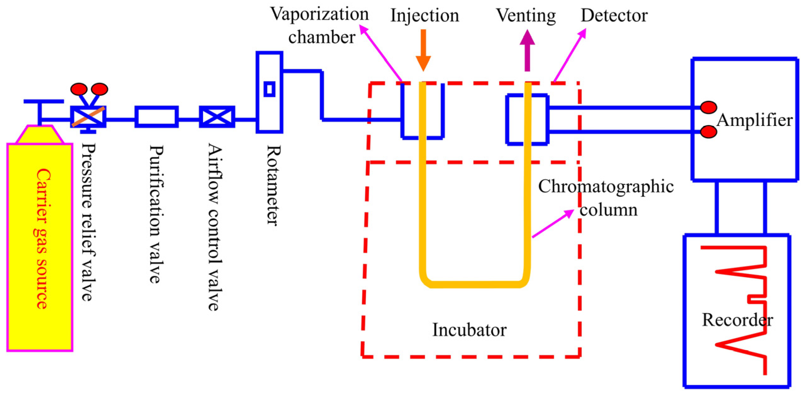
The experimental procedure for the detection of the helium content in natural gas using gas chromatography is shown in Figure 2. The samples were injected into the injection port using a microsyringe. Then they were carried into the vaporization chamber by the carrier gas under a certain pressure and flow rate. The samples entered the chromatographic column with the carrier gas after vaporization. When the vaporized sample mixtures were carried into the chromatographic column by the carrier gas, the speed at which each component traveled through the column varied due to differences in their boiling points. The components underwent repeated (103–105 times) distribution (adsorption–desorption or dissolution–release) between the two phases. Since the stationary phase had different adsorption or dissolution capacities for each component (i.e., different retention times), the components moved through the column at different speeds. They were separated after traveling a certain column length. Thus, the samples were separated after passing through the chromatographic column. Each component was eluted from the column in a specific order. Components were detected and recorded after passing through the detectors (e.g., FID or TCD), which resulted in a chromatographic peak. A series of chromatographic peaks formed the chromatogram, where different peaks represented alkane components with different structures and carbon numbers.

4. Results

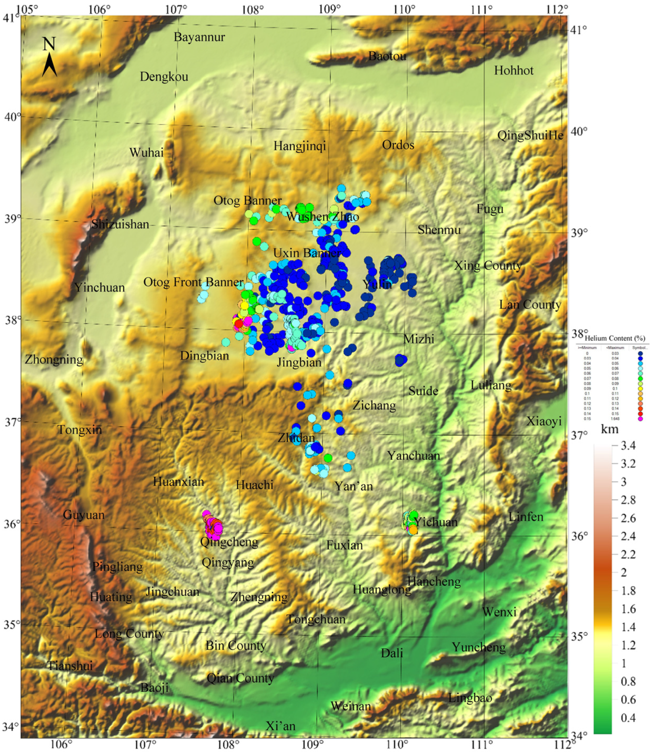
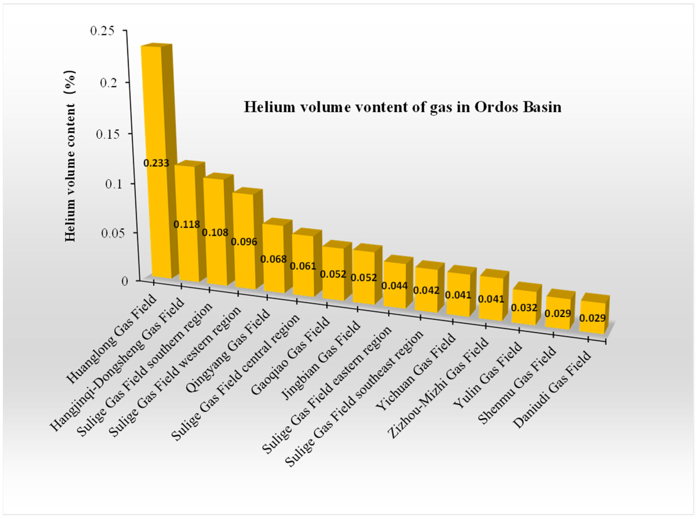
The distribution of helium in natural gas within the Ordos Basin exhibits significant spatial heterogeneity (Figure 3). Helium content detection shows considerable variation in the volume fraction of He among different gas fields in the basin, ranging from 0.029 to 0.233% (Figure 4). The Huanglong Gas Field has the highest helium enrichment, with a helium volume fraction of 0.233%, followed by the Hangjinqi–Dongsheng Gas Field (0.118%) and southern Sulige Gas Field (0.108%). In contrast, Daniudi and Shenmu Gas Fields have the lowest helium content (both at 0.029%). This stepped distribution pattern suggests significant differences in helium accumulation mechanisms across different structural units.
Spatially, high helium contents predominantly exhibit annular distribution along the basin periphery, with particularly prominent anomalies observed near the Yichuan–Qingyang tectonic belt (Figure 3). The high-value zone demonstrates spatial coupling with deep-seated fault systems and Precambrian basement uplift zones, indicating the channeling control of basement fault activity in vertical helium migration. In contrast, the central basin displays uniformly low background helium (<0.1%), closely corresponding to areas with thick Mesozoic caprock and reflecting the inhibitory effect of impermeable seals on upward He diffusion. This distribution pattern of enriched periphery vs. depleted center reveals a synergistic helium control mechanism governed by the basement tectonic framework, fault network system, and sedimentary preservation conditions.
To ensure data reliability, 10 representative samples were selected and sent to the National Engineering Laboratory for Low-permeability Oil & Gas Field Exploration and Development, as well as the PetroChina Research Institute of Petroleum Exploration & Development (RIPED), for cross-validation of helium content measurements (Table 1). The results from three independent laboratories show strong consistency, confirming the reliability of experimental helium content data.

5. Discussion

5.1. Origin of Helium in the Ordos Basin

Figure 5 shows the process of helium generation and accumulation in natural gas reservoirs. Helium is produced through the α-decay of radioactive elements U and Th within rock mineral grains. Its generation is a function of time and the contents of precursor elements (U and Th). The abundance of U and Th in source rocks, along with the rock’s age, determines the helium generation potential.
Helium migrates from solid mineral grains into pore water and accumulates there. Older, stagnant formation water tends to contain higher helium contents compared to younger, flowing formation water. When natural gas comes into contact with water, helium partitions into the gas phase, which is the step to determine the helium content in the gas [3]. Once incorporated into the gas phase, He migrates with the gas into traps. This migration mechanism is identical to conventional gas accumulation processes, with the helium content altered only through dilution or mixing.
Uranium (U) and thorium (Th) in rocks exist in multiple forms, mainly encompassing discrete U and Th minerals (e.g., pitchblende, uraninite, wisaksonite, thorite, and thorianite), isomorphic substitution within mineral structures (e.g., zircon, monazite, apatite, and sphene), and dispersed adsorption states, with organic matter and clay minerals serving as effective adsorbents [28]. Table 2 and Table 3 lists the abundance, occurrence states, and helium release characteristics of U and Th in different types of rocks.
The 3He/4He ratio serves as a key indicator for determining the origin of helium. Atmospheric helium: 1.4 × 10⁻⁶; crustal helium: 2 × 10⁻⁸; and mantle-derived helium: 1.1 × 10⁻⁵. 3He/4He ratio > 10−6, indicating the significant contribution of mantle-derived helium. Based on the analysis of 46 gas samples from the Ordos Basin, Dai et al. found that the 3He/4He ratio ranges from 3.1 × 10⁻⁸ to 1.2 × 10⁻⁷, with an average of 4.36 × 10⁻⁸, which is characteristic of crustal helium [30]. The Ordos Basin has remained tectonically stable since the Paleozoic, with no magmatic activity. The R/Ra ratio (3He/4He relative to atmospheric helium) in the samples further confirms the basin’s tectonic stability and the absence of mantle-derived helium mixing.
Potential helium source rocks rich in radioactive U and Th (e.g., Archean granite gneiss, quartz sandstone, and quartzite, Meso-Neoproterozoic metamorphic quartzite, quartz sandstone, dark gray mudstone, and gneiss, Carboniferous–Permian coal and carbonaceous mudstone, as well as the Chang 7 oil shale of the Yanchang Formation from the northern DongSheng Gas Field and Daniudi Gas Field) are selected for analyzing released gases. This approach aims to clarify the helium sources of major gas fields in the Ordos Basin. The 3He/4He and 40Ar/36Ar ratios in the released gases are compared with those in the Upper Paleozoic natural gas (Figure 6).
The helium isotope ratios (3He/4He) in the Upper Paleozoic natural gas of the Dongsheng Gas Field are relatively low, ranging in (1.83–6.25) × 10−8. Similarly, in the Daniudi Gas Field, the 3He/4He ratios of Paleozoic natural gas are low, distributed in (2.83–6.07) × 10−8, with R/Ra ratios ranging from 0.020 to 0.043. Specifically, the Lower Paleozoic natural gas exhibits 3He/4He ratios ranging in (2.97–6.07) × 10−8 (average: 3.78 × 10⁻⁸), while the Upper Paleozoic gas ranges in (2.83–3.57) × 10−8 (average: 3.21 × 10⁻⁸).
The 3He/4He ratios show little variation between the Upper and Lower Paleozoic natural gas and follow a similar trend to those in the released gases from Archean–Proterozoic metamorphic–granitic basement rocks, as well as their 40Ar/36Ar ratios. Their distribution ranges are consistent, in contrast to sedimentary rocks such as the Upper Paleozoic coal-measure source rocks and the Yanchang Formation source rocks. Helium in the Upper Paleozoic natural gas originates from the Archean–Proterozoic basement rocks [27,31,32]. Helium in the Upper Paleozoic natural gas is typically crust-derived, primarily generated via the radioactive decay of Archean–Proterozoic metamorphic–granitic basement rocks. Notably, Carboniferous–Permian coal-measure source rocks and U/Th-rich Chang 7 sedimentary rocks contribute insignificantly to helium generation [31].

5.2. Main Controlling Factors of Helium Accumulation in the Ordos Basin

The key factors controlling helium accumulation include large-scale helium source rocks, effective migration pathways, and favorable preservation conditions [1]. Crust-derived helium is generated through the α-decay of radioactive elements such as U and Th. Therefore, the formation of crust-derived helium reservoirs first requires large-scale source rocks enriched in U and Th. For hydrocarbon carriers and crust-derived helium to migrate from deep sources to shallow reservoirs, effective migration pathways (e.g., faults and unconformities) are essential. Deep-rooted faults and fractures serve as highly efficient migration channels for He.
Helium has a strong diffusivity and penetration ability due to its extremely small molecular radius (0.26 nm) compared to methane (0.42 nm), which makes it prone to escape. Consequently, He accumulation demands more stringent preservation conditions than hydrocarbon reservoirs. Crust-derived helium reservoirs require high-quality, thick seals (e.g., salt rocks and mudstones) to prevent the diffusion and leakage of both hydrocarbons and helium. Three controlling factors are discussed in detail for the Ordos Basin’s helium reservoirs.
(1) He source rocks
Since the discussion in Section 5.1 has ruled out mudstone, shale, coal, and other sedimentary rocks as the primary helium source rocks in the Ordos Basin, the following analysis will focus on metamorphic rocks and granites in the basement as potential helium source rocks.
The reduced-to-pole (RTP) magnetic anomaly (Figure 7) can reflect the basement structure and lithological distribution, with the magnetic anomalies primarily indicating the lithology of the basement. High magnetic anomaly values mainly correspond to basement sections dominated by strongly magnetic rocks such as igneous and metamorphic rocks. Based on the magnetic characteristics of the rocks listed in Table 4 and the lithology of some basement-drilling wells in Figure 8, the areas with high RTP magnetic anomalies are composed of Archean granulite, gneiss, and other metamorphic rocks, as well as diorite, granite, and other magmatites. These rocks are distributed in large, banded zones across the northern, central, and southern parts of the basin. In contrast, areas with low RTP magnetic anomalies are primarily composed of metamorphosed sedimentary rocks such as marble and migmatite. These basement lithological divisions may reflect the early amalgamation characteristics of the basin.
A comparison between the helium content checkpoints and magnetic anomaly distribution reveals that wells with a high helium content are predominantly located along regional high-magnetic-anomaly belts; however, those with a relatively low helium content are mostly distributed in low-magnetic-anomaly zones. Wells with a high He content in the Qingyang region are situated along a NE-trending high-magnetic-anomaly belt in the central part of the basin (Figure 7). Those with a relatively low helium content are located in regions within the low-magnetic-anomaly zones of the basin (e.g., east of Otog Front Banner and Yichuan). Based on the magnetic susceptibility analysis of different rock types, helium generation is associated with strongly magnetic metamorphic rocks (e.g., gneiss, granulite, and granitic gneiss) and granites, which serve as helium source rocks. The NE-trending high-magnetic-anomaly belts in the basin are the primary distribution zones of these rocks.
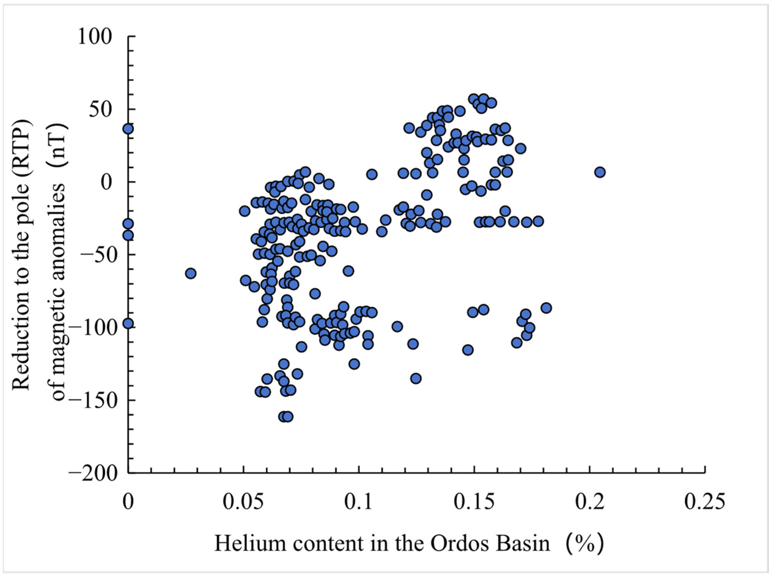
There is a certain positive correlation between the helium content and RTP magnetic anomaly values in the Ordos Basin (Figure 8). That is, the higher the magnetic anomaly value, the greater the helium content. Helium in the Ordos Basin primarily originates from highly magnetic basement rocks. Based on the above analysis, the magmatic and metamorphic rocks in the basement of the Ordos Basin—these highly magnetic lithologic bodies—serve as the primary helium source rocks in the basin.
(2) Faults
In addition to large-scale helium source rocks, effective migration pathways are crucial controlling factors for the formation of helium gas reservoirs. The Bouguer gravity anomaly reflects density inhomogeneity below the observation surface. Lateral density variations in geological structures cause changes in gravity anomalies. The further processing of Bouguer gravity anomalies can enhance the identification of faults and other structural features.
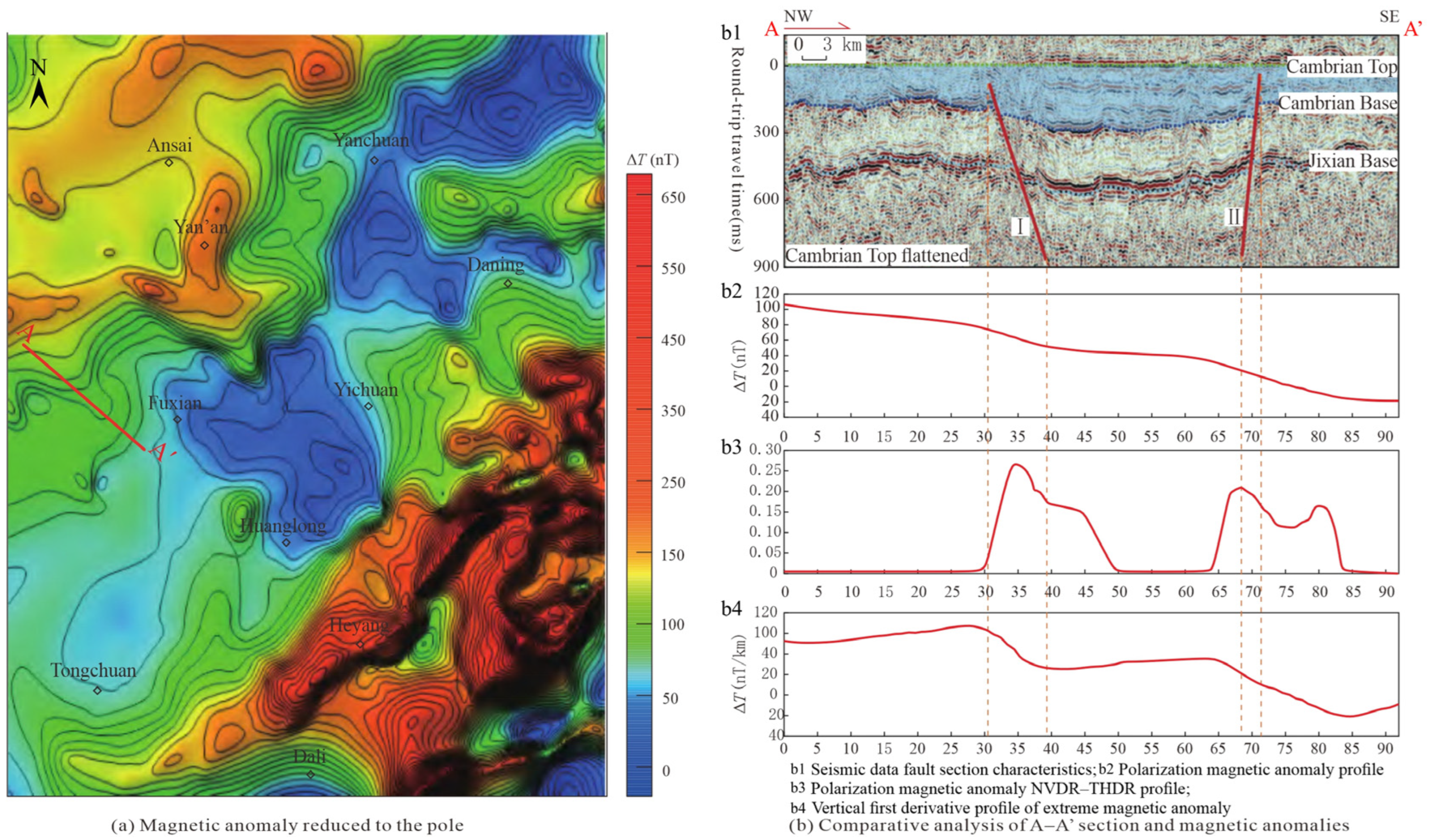
The normalized vertical derivative of the total horizontal derivative (NVDR-THDR) edge detection technique [34] is a potential field interpretation method combining horizontal and vertical derivatives. Linear structures are highlighted at the boundaries of rock masses or geological bodies by calculating the vertical characteristics of the total horizontal derivative. The NVDR-THDR map of RTP magnetic anomalies can delineate the distribution of faults. The positions or dislocation of the maxima in the map serve as key indicators for identifying the planar locations of faults, and this method has been widely applied. A comparison is made between faults interpreted from seismic data and the maxima in the NVDR-THDR map (Figure 9). The locations with larger peaks show good agreement with the fault positions interpreted from the seismic profile.
The reliability of the fault identification method is assessed through a comparative analysis performed along seismic profile A-A’ (Figure 9(b1)) [35], located in the central-southern part of the basin. This analysis utilized three datasets: RTP magnetic anomalies, NVDR-THDR derived from these RTP anomalies, and the first vertical derivative of the RTP magnetic anomalies (Figure 9).
The RTP magnetic anomalies along this profile decrease from the NW to the SE, with a noticeable reduction at fault locations (Figure 9(b2)). The maxima in the NVDR-THDR profile of RTP magnetic anomalies coincide with the faults interpreted from the seismic profile (Figure 9(b3)), which aligns with the fault identification criteria of this technique. The faults correspond to the boundaries between high and low anomaly values as well as the zero-value line in the first vertical derivative profile of RTP magnetic anomalies (Figure 9(b4)), which provides a clear reflection of faults in this derivative. The NVDR-THDR technique proves highly reliable for fault identification. The structural characteristics of faults in the study area can be delineated by integrating this method with geological data.
The Bouguer gravity anomaly reflects comprehensive density inhomogeneity beneath the observation surface. When geological structures exhibit lateral density variations, they induce changes in the gravity anomaly. Information such as basement faults can be highlighted (Figure 10) by processing the Bouguer gravity anomaly map of the basin using the NVDR-THDR technique.
Wei et al. [35] comprehensively utilized seismic, well logging, drilling, and outcrop data to study the fault characteristics of the Cambrian system in the Ordos Basin. The Cambrian system develops three sets of faults: NE-trending, nearly EW-trending, and NW-trending. Figure 1 shows the partial interpretation of the north–south seismic profile in the Ordos Basin. Two-dimensional seismic profiles reveal that the Mesoproterozoic Changcheng and Jixian systems exhibit response characteristics of deep-seated faults and rifts, manifested as alternating graben–horst structures with double or single faults [25]. Deep-seated faults can transport helium generated in the basement to the shallow Paleozoic strata. The research of He et al. [26] also indicates that the basement faults in the Ordos Basin have multi-stage activity and vertical superimposed development. The activity history of the basin margin faults plays a significant conductive role in the stratified activity of faults within the basin, which provides effective migration channels for helium accumulation.
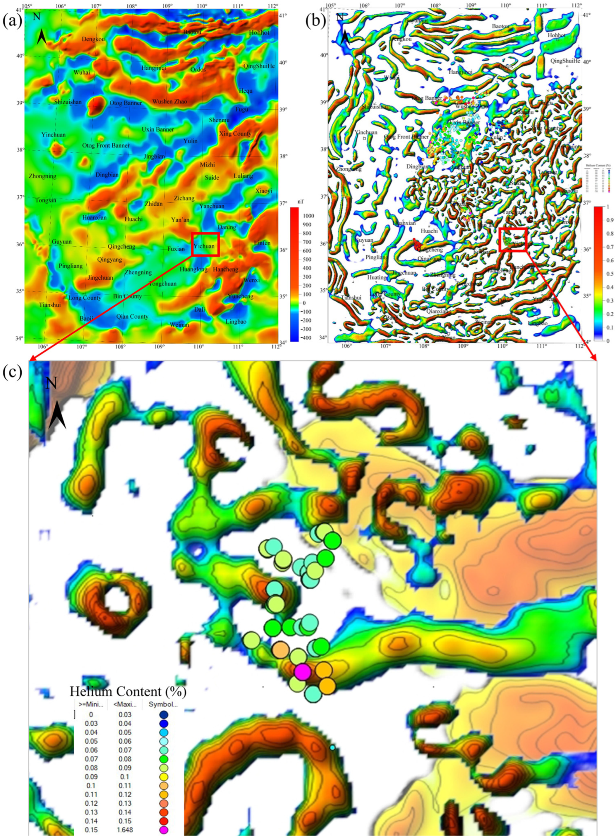
From the distribution of the helium content at sampling points in the basin, although areas with high magnetic anomalies generally exhibit higher helium contents, there is no direct correlation between a high helium content and localized magnetic anomaly peaks. This indicates that helium migration occurs after its generation. The Yichuan–Huanglong area is taken as an example for analysis to better illustrate the relationship between helium distribution and fault distribution within the Ordos Basin. The Bouguer gravity anomaly NVDR-THDR map reflects fault distribution (represented by protruding color bands in the figure); the RTP magnetic anomaly map indicates the distribution of helium source rocks (shown as orange-yellow blocks to the right of helium sampling points).
The RTP magnetic anomaly map is superimposed on the Bouguer gravity anomaly NVDR-THDR map (Figure 11). Locations with peak NVDR-THDR (signaling well-developed faults, visible as prominent yellow-green bands) generally exhibit helium contents above 0.1% in the Yichuan–Huanglong area. In contrast, areas adjacent to these maxima (where faults are less developed, shown as blank spaces beside the protruding bands) have a relatively lower helium content. Helium migrates along basement faults after being released from helium source rocks in high-magnetic-anomaly zones. Therefore, the distribution of helium in the Ordos Basin is closely related to basement faults.
(3) Caprocks
Dense gypsum–salt layers, limestone, and shale serve as effective cap rocks for helium-rich natural gas reservoirs [36]. Tyne et al. [37] employed numerical modeling to establish a diffusion-release model for helium in formations. Salt rock strata can block the vertical diffusion of He, which acts as effective caprocks for helium-rich natural gas reservoirs. Overpressured caprocks and water-/brine-saturated caprocks can also serve as excellent seals, providing favorable confinement conditions for helium-rich gas reservoirs. When the rock pores of a caprock are sealed with water, the water-saturated caprock can significantly slow helium loss due to helium’s low solubility in water. Given helium’s small molecular diameter (0.26 nm) and high diffusion coefficient, no caprock of any rock type can completely prevent helium diffusion. However, helium exists in formations as heterogeneous co-accumulation-associated gases owing to Henry’s law and the assistance of carrier gases. Helium is preserved by high-quality caprocks under the triple confinement of physical properties, pressure, and concentration [38,39]. Therefore, a stable helium-rich natural gas reservoir requires a caprock with excellent sealing properties and a helium replenishment rate exceeding the loss rate [40]. The Ordos Basin features multiple sets of caprocks, including the Ordovician Majiagou Formation gypsum–salt rock, the Upper Shihezi Formation mudstone of the Permian, and the thick Mesozoic shale, which provide favorable conditions for helium preservation.
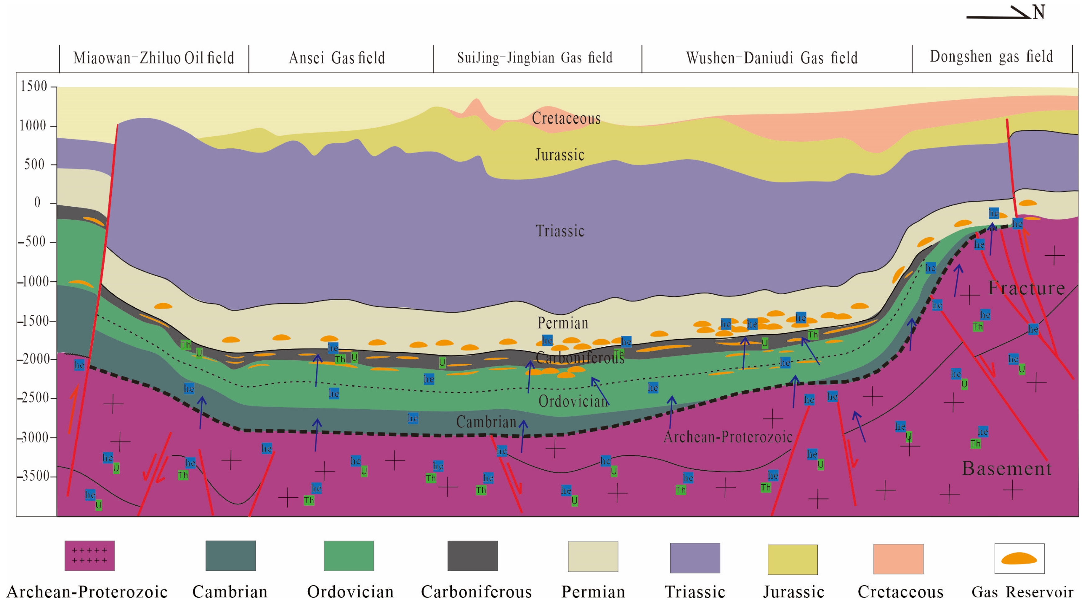
(4) Helium accumulation model
Based on the above analysis, the helium accumulation model in the Ordos Basin can be summarized as basement-generated helium, fault-migrated helium, and caprock-sealed helium. That is, the metamorphic rocks and granites with strong magnetism in the basin basement serve as helium source rocks. Helium migrates along the faults in the basin basement and accumulates in suitable traps for preservation after generation. The distribution of helium is controlled by the lithofacies of the basement and deep major faults. High-helium-content zones are primarily distributed along both sides of the basement faults. Enrichment occurs at the intersections of secondary faults connected to helium source faults and fourth-order faults in the transport system, as well as in areas where Archean–Paleoproterozoic metamorphic rocks and magmatic basement rocks are developed [26,40]. Fourth-order faults exhibit excellent transport properties and connect the basement helium source rocks with the reservoir layers, which control the planar and vertical distribution of helium. Helium preferentially accumulates in traps containing hydrocarbon and other non-hydrocarbon gas reservoirs during upward migration. It exhibits a favorable spatiotemporal configuration with the conventional gas reservoirs of the Upper Paleozoic in terms of reservoir, caprock, and trap combinations, which form He-rich natural gas reservoirs (Figure 12).

6. Conclusions

(1)
The helium content in natural gas from the Ordos Basin ranged from 0.029 to 0.233% by volume on average, exhibiting a distribution pattern of enrichment at the margins and depletion in the central region. The primary helium source was the radioactive decay of elements within basement metamorphic–magmatic rocks. Notably, higher helium contents were observed in the Qingyang Paleo-Uplift and Yimeng Uplift areas.
(2)
The Ordos Basin featured well-developed basement faults, which served as effective migration pathways for helium. Helium migrated along these basement faults after generation, which resulted in significantly higher helium contents along fault zones compared to the surrounding areas.
(3)
A model was established for helium accumulation in the Ordos Basin, incorporating basement generation, fault migration, and caprock sealing. The overall distribution of helium was controlled by the distribution of basement helium source rocks, while local enrichment was influenced by basement fault systems.

Author Contributions

Conceptualization, D.W. and L.M.; methodology, D.W.; software, D.Z.; validation, D.Z., X.J., L.M. and T.Z.; investigation, T.Z.; resources, D.W.; data curation, D.Z.; writing—original draft preparation, D.W. and J.P.; writing—review and editing, L.M. and J.P.; visualization, G.W.; supervision, T.Z.; project administration, G.W.; funding acquisition, X.J. All authors have read and agreed to the published version of the manuscript.

Funding

This research was funded by the National Natural Science Foundation of China (NSFC), grant number U2244209.

Institutional Review Board Statement

Not applicable.

Informed Consent Statement

Not applicable.

Data Availability Statement

The datasets generated during and/or analyzed during the current study are available from the corresponding author upon reasonable request.

Conflicts of Interest

Author Dahai Wang, Lichi Ma, Tao Zhang, Dongya Zhu and Xiaohui Jin were employed by China Petroleum Exploration and Development Research Institute, China Petroleum & Chemical Corporation. Author Guojun Wang was employed by the company Pengbo Operations Company, CNOOC (China) Ltd., China National Offshore Oil Corporation. The remaining author declares that the research was conducted in the absence of any commercial or financial relationships that could be construed as a potential conflict of interest.

References

  1. Wang, D.; Li, J.; Yu, Z.; Zhang, J.; Liu, L.; Xiao, F.; Shan, C. The Resource Potential and Development Prospect of Helium in Changqing Gas Field. Geofluids 2022, 2022, 9094667. [Google Scholar] [CrossRef]
  2. Brown, A. Origin of helium and nitrogen in the Panhandle–Hugoton field of Texas, Oklahoma, and Kansas, United States. AAPG Bull. 2019, 103, 369–403. [Google Scholar] [CrossRef]
  3. Brown, A. Formation of High Helium Gases: A Guide for Explorationists. In Proceedings of the AAPG Convention, New Orleans, LA, USA, 11–14 April 2010. [Google Scholar]
  4. Li, Y. Accumulation Conditions and Resource Prospects of Helium in the Weihe Basin; Geological Publishing House: Beijing, China, 2022. [Google Scholar]
  5. Anderson, S.T. Economics, Helium, and the U.S. Federal Helium Reserve: Summary and Outlook. Nat. Resour. Res. 2018, 27, 455–477. [Google Scholar] [CrossRef]
  6. Ballentine, C.J.; Burnard, P.G. Production, Release and Transport of Noble Gases in the Continental Crust. Rev. Mineral. Geochem. 2002, 47, 481–538. [Google Scholar] [CrossRef]
  7. Lucas, J.R.; Batenburg, S.J.; Hillegonds, D.J.; Mabry, J.C.; Jenkyns, H.C.; Ballentine, C.J.; Robinson, S.A. Helium-isotope constraints on palaeoceanographic change and sedimentation rates during precession cycles (Cenomanian Scaglia Bianca Formation, central Italy). Sedimentology 2024, 71, 1895–1921. [Google Scholar] [CrossRef]
  8. Oxburgh, E.R.; O’Nions, R.K.; Hill, R.I. Helium isotopes in sedimentary basins. Nature 1986, 324, 632–635. [Google Scholar] [CrossRef]
  9. Kennedy, B.M.; van Soest, M.C. Flow of Mantle Fluids Through the Ductile Lower Crust: Helium Isotope Trends. Science 2007, 318, 1433–1436. [Google Scholar] [CrossRef] [PubMed]
  10. Ballentine, C.J.; Sherwood Lollar, B. Regional groundwater focusing of nitrogen and noble gases into the Hugoton-Panhandle giant gas field, USA. Geochim. Cosmochim. Acta 2002, 66, 2483–2497. [Google Scholar] [CrossRef]
  11. Liu, Y. Geochemistry of the Elements; Science Press: Beijing, China, 1984. [Google Scholar]
  12. Franz, J.D. Uranium Ore Deposits; Springer: Berlin/Heidelberg, Germany, 1993. [Google Scholar]
  13. Wang, X.; Liu, Q.; Liu, W.; Li, X.; Tao, C.; Li, X.; Zhao, D.; Zhang, J.; Zhu, D.; Meng, Q. Helium accumulation in natural gas systems in Chinese sedimentary basins. Mar. Pet. Geol. 2023, 150, 106155. [Google Scholar] [CrossRef]
  14. Landais, P. Organic geochemistry of sedimentary uranium ore deposits. Ore Geol. Rev. 1996, 11, 33–51. [Google Scholar] [CrossRef]
  15. Syed, H.S. Comparison studies adsorption of thorium and uranium on pure clay minerals and local Malaysian soil sediments. J. Radioanal. Nucl. Chem. 1999, 241, 11–14. [Google Scholar] [CrossRef]
  16. Wang, D.; Nie, J.; Lin, J.; Pang, Y.; Wang, Z.; Qin, K. Geochemical Properties and Mineralization Processes of Uranium. Tecton. Miner. 2022, 46, 282–302. [Google Scholar]
  17. Tedesco, S.A. Geology and Production of Helium and Associated Gases; Elsevier: Amsterdam, The Netherlands, 2022. [Google Scholar]
  18. Gilfillan, S.M.V.; Ballentine, C.J.; Holland, G. The noble gas geochemistry of natural CO2 gas reservoirs from the Colorado Plateau and Rocky Mountain provinces, USA. Geochim. Cosmochim. Acta 2008, 72, 1174–1198. [Google Scholar] [CrossRef]
  19. Zhang, C.; Gong, M.; Tian, W.; He, Y.; Zhu, D.; Wang, L. Evaluation of Helium Resources and Accumulation Model in the Yakela Area, Tarim Basin. Nat. Gas Geosci. 2023, 34, 1993–2008. [Google Scholar]
  20. Liu, K.; Chen, J.; Fu, R.; Wang, H.; Luo, B.; Dai, X.; Yang, J. Discussion on the Distribution Patterns and Controlling Factors of Helium-Rich Natural Gas in the Weiyuan Gas Field. J. China Univ. Pet. (Nat. Sci. Ed.) 2022, 46, 12–21. [Google Scholar]
  21. Chen, X.; Chen, G.; Bian, R.; Du, W. Helium Resource Potential and Genesis Mechanism in the Fuling Shale Gas Field, Sichuan Basin. Nat. Gas Geosci. 2023, 34, 469–476. [Google Scholar]
  22. Qin, S.; Dou, L.; Tao, G.; Li, J.; Qi, W.; Li, X.; Guo, B.; Zhao, Z.; Wang, J. Helium Enrichment Theory and Exploration Ideas for Helium-Rich Reservoirs. Pet. Explor. Dev. 2024, 51, 1340–1356. [Google Scholar] [CrossRef]
  23. Hassanpouryouzband, A.; Armitage, T.; Cowen, T.; Thaysen, E.M.; MCMahon, S.; Hajibeygi, H.; Stevenson, D.S.; Stahl, M.; Haszeldine, R.S. The Search for Natural Hydrogen: A Hidden Energy Giant or an Elusive Dream? ACS Energy Lett. 2025, 10, 3887–3891. [Google Scholar] [CrossRef]
  24. Hassanpouryouzband, A.; Wilkinson, M.; Haszeldine, R.S. Hydrogen energy futures–foraging or farming? Chem. Soc. Rev. 2024, 53, 2258–2263. [Google Scholar] [CrossRef]
  25. Zhao, W.; Hu, S.; Wang, Z.; Zhang, S.; Wang, T. Geological Conditions and Exploration Status of Proterozoic–Cambrian Oil and Gas in China. Pet. Explor. Dev. 2018, 45, 1–14. [Google Scholar] [CrossRef]
  26. He, F.; Wang, J.; Zhao, Y.; An, C.; Wang, F.; Tao, C.; Ni, C.; Jia, H. Accumulation Characteristics and Tectonic Background of the East Sheng Helium-Rich Gas Field, Ordos Basin. Acta Palaeogeogr. Sin. 2022, 24, 937–950. [Google Scholar]
  27. Sun, X.; Wang, J.; Cheng, T.; Zhang, Y.; Jia, H.; Jiang, H.; Ma, L.; Wang, F. Geochemical Characteristics and Integrated Source Identification of Paleozoic Natural Gas in Daniutiaoten, Ordos Basin. Pet. Geol. Exp. 2021, 43, 307–314. [Google Scholar]
  28. Keppler, H.; Wyllie, P.J. Role of fluids in transport and fractionation of uranium and thorium in magmatic processes. Nature 1990, 348, 531–533. [Google Scholar] [CrossRef]
  29. Wang, X.; Zhao, D.; Zhang, D.; Li, X.; Chen, K.; Liu, W. Effective Helium Source-Rock Types and Helium Release Mechanism. Nat. Gas Geosci. 2025, 36, 381–389. [Google Scholar]
  30. Dai, J.; Li, J.; Hou, L. Characteristics of Helium Isotopes in the Ordos Basin. J. High. Educ. Geol. 2005, 11, 473–478. [Google Scholar]
  31. He, F.; Wang, F.; Wang, J.; Zou, Y.; An, C.; Zhou, X.; Ma, L.; Zhao, Y.; Zhang, J.; Liu, D.; et al. Helium Distribution in the East Sheng Gas Field, Ordos Basin, and Discovery of a Giant Helium-Rich Gas Field. Pet. Geol. Exp. 2022, 44, 1–10. [Google Scholar]
  32. Gao, Y.; Liu, Q.; Wu, X.; Zhu, D.; Li, P. Differences in Crustal-Derived Helium Accumulation between Dongsheng and Daniutiaoten Gas Fields, Ordos Basin. Nat. Gas Geosci. 2023, 34, 1790–1800. [Google Scholar]
  33. Fan, L.; Shan, C.; Li, J.; Feng, X.; Yu, Z.; Wang, D. Helium Distribution Patterns in the Ordos Basin Based on Magnetic Data. Nat. Gas Geosci. 2023, 34, 1780–1789. [Google Scholar]
  34. Wang, W.; Pan, Y.; Qiu, Z. A new edge recognition technology based on the normalized vertical derivative of the total horizontal derivative for potential field data. Appl. Geophys. 2009, 6, 226–233. [Google Scholar] [CrossRef]
  35. Wei, G.; Zhu, Q.; Yang, W.; Zhang, C.; Mo, W. Characteristics of Cambrian Faults in the Ordos Basin and Their Control on Sedimentary Reservoirs. Pet. Explor. Dev. 2019, 46, 836–847. [Google Scholar] [CrossRef]
  36. Broadhead, R.F. Helium in New Mexico—Geologic distribution, resource demand, and exploration possibilities. N. M. Geol. 2005, 27, 93–101. [Google Scholar]
  37. Tyne, R.; Barry, P.; Cheng, A.; Hillegonds, D.; Kim, J.-H.; McIntosh, J.; Ballentine, C. Basin architecture controls on the chemical evolution and 4He distribution of groundwater in the Paradox Basin. Earth Planet. Sci. Lett. 2022, 589, 117580. [Google Scholar] [CrossRef]
  38. Zhang, C.; Gong, M.; Tian, W.; He, Y.; Zhu, D.; Wang, L. Investigation into Caprock Characteristics of Helium Resources: A Case from the Tarim Basin. Geol. Rev. 2024, 70, 1192–1204. [Google Scholar]
  39. Li, Y.; Zhang, W.; Wang, L.; Zhao, F. Henry’s Law and Weak Crustal-Source Helium Accumulation: A Case from the Weihe Basin. Nat. Gas Geosci. 2017, 28, 495–501. [Google Scholar]
  40. Tao, S.; Yang, Y.; Chen, Y.; Liu, X.; Yang, W.; Li, J.; Wu, Y.; Tao, X.; Gao, J.; Chen, Y.; et al. Geological Conditions, Genetic Mechanisms, and Accumulation Patterns of Helium Resources. Pet. Explor. Dev. 2024, 51, 498–518. [Google Scholar] [CrossRef]
Figure 1. Geological overview of the Ordos Basin (based on Sun, 2021; He, 2022; Zhao, 2018) [25,26,27].
Applsci 15 08806 g001
Figure 2. Experimental process for detecting helium content in natural gas using gas chromatography.
Applsci 15 08806 g002
Figure 3. Planar distribution of helium content in natural gas of the Ordos Basin.
Applsci 15 08806 g003
Figure 4. Helium content in natural gas from the Ordos Basin.
Applsci 15 08806 g004
Figure 5. Helium generation and migration (based on Brown et al., 2010) [3].
Applsci 15 08806 g005
Figure 6. Genetic classification and source identification of helium in the Paleozoic natural gas of the Ordos Basin (based on the research of He et al., 2022) [26].
Applsci 15 08806 g006
Figure 7. RTP magnetic anomaly of the Ordos Basin.
Applsci 15 08806 g007
Figure 8. Relationship between RTP magnetic anomaly values and helium content.
Applsci 15 08806 g008
Figure 9. NVDR-THDR edge detection technology.
Applsci 15 08806 g009
Figure 10. NVDR-THDR map of Bouguer gravity anomalies (delineating faults).
Applsci 15 08806 g010
Figure 11. Relationship between helium distribution, faults, and basement helium source rocks. (a) RTP magnetic anomaly of the Ordos Basin (helium source rocks). (b) NVDR-THDR processed Bouguer gravity anomaly (basement faults). (c) Superimposition of helium distribution, RTP magnetic anomaly, and NVDR-THDR processed Bouguer gravity anomaly in the Yihuang area.
Applsci 15 08806 g011
Figure 12. He accumulation model in the Ordos Basin.
Applsci 15 08806 g012
Table 1. Cross-validation of helium measurement reliability.
Well No.Shaanxi Key Laboratory of Petroleum Accumulation GeologyNational Engineering Laboratory for Exploration and Development of Low-Permeability Oil & Gas FieldsResearch Institute of Petroleum Exploration & Development
Su B-10.0250.02
Su B-20.0330.03
Jing A-10.0330.03
Su C0.0330.03
Jing A-20.0340.03
Su B-30.0410.04
Su B-40.034 0.03
Shuang A0.018 0.02
Jing A-30.04 0.04
Zhao A0.043 0.04
Table 2. Occurrence forms of U and Th and helium release characteristics in different types of source rocks [29].
Rock TypeDistribution Pattern of U and ThOccurrence Forms of U and ThU- and Th-Rich Rock TypesHelium Release Characteristics
Sedimentary rocksPrimary U and Th contents increase with higher organic matter and clay mineral content.Mainly adsorbed/complexed by organic matter and clay minerals.Black shales and bauxite rocks.Helium’s high porosity and strong solubility in formation water hinder its release, allowing helium produced in source rocks and reservoirs to accumulate efficiently.
Magmatic rocksAcidic rocks have the highest U and Th contents, while mafic rocks have the lowest; late-crystallized portions contain more U and Th than early-crystallized ones.Mainly enriched in silicate and phosphate minerals via isomorphism.Granite.Low porosity and weak helium solubility. Tectonic uplift and fracturing lead to large-scale helium releases.
Metamorphic rocksContent depends on protolith U/Th content and metamorphic grade; high-grade metamorphism mobilizes U and Th.Multiple occurrence forms coexist; mobilized U and Th entering fluids.Lightly metamorphosed rocks derived from U- and Th-rich protoliths.Porosity is higher than granite, with moderate formation water solubility for helium, which makes helium relatively difficult to release.
Table 3. Helium releases from radioactive decay of different elements [29].
NuclideHalf-LifeDaughterYield
(Atoms/Decay)
Comments
3H12.263He1Continuously produced in atm
238U4.468 Ga4He8 Spontaneous fission
136Xe3.6 × 10−8
(4.4 ± 0.1) × 10−8
235U0.7038 Ga4He7 238U/235U = 137.88
232Th14.01 Ga4He6 Th/U = 3.8 in bulk Earth
136Xe<4.2 × 10⁻¹¹ No significant production in Earth
40K1.251 Ga40Ar0.1048 40K = 0.01167% total K
244Pu80.0 Ma136Xe7.00 × 10−5244Pu/238U = 6.8 × 10⁻³ at 4.56 Ga
129I15.7 Ma129Xe1129I/127I = 1.1 × 10⁻⁴ at 4.56 Ga
Table 4. Magnetic susceptibility characteristics of rock formations in the Ordos Basin [33].
EraStratum/Rock MassMagnetic Susceptibility/(10−5)
RangeAverage
CenozoicQuaternary system36~7956
Paleogene and Neogene5~139.6
MesozoicCretaceous system10.5~58.918.6
Jurassic system6.5~17.310.5
Triassic system8.8~18.615.3
Paleozoic erathemPermian system2.5~22.016.3
Carboniferous system3.2~20.89.6
Ordovician system5.6~14.68.8
Cambrian system10.5~16.812.7
Proterozoic 5.4~9.27.8
ArcheanGranulite1300~10,6005600
Gneiss8.6~1400780
Migmatite10.5~16.813.6
Marble11.6~24518.4
Diorite40~95455332
Disclaimer/Publisher’s Note: The statements, opinions and data contained in all publications are solely those of the individual author(s) and contributor(s) and not of MDPI and/or the editor(s). MDPI and/or the editor(s) disclaim responsibility for any injury to people or property resulting from any ideas, methods, instructions or products referred to in the content.