

Discovery of an Intact Quaternary Paleosol, Georgia Bight, USA
 , , ,
, , ,
Abstract
1. Introduction
2. Objectives and Methods
- a.
- What kind of soil?
- b.
- How old is the soil?
- c.
- What type of environment is indicated by the soil?
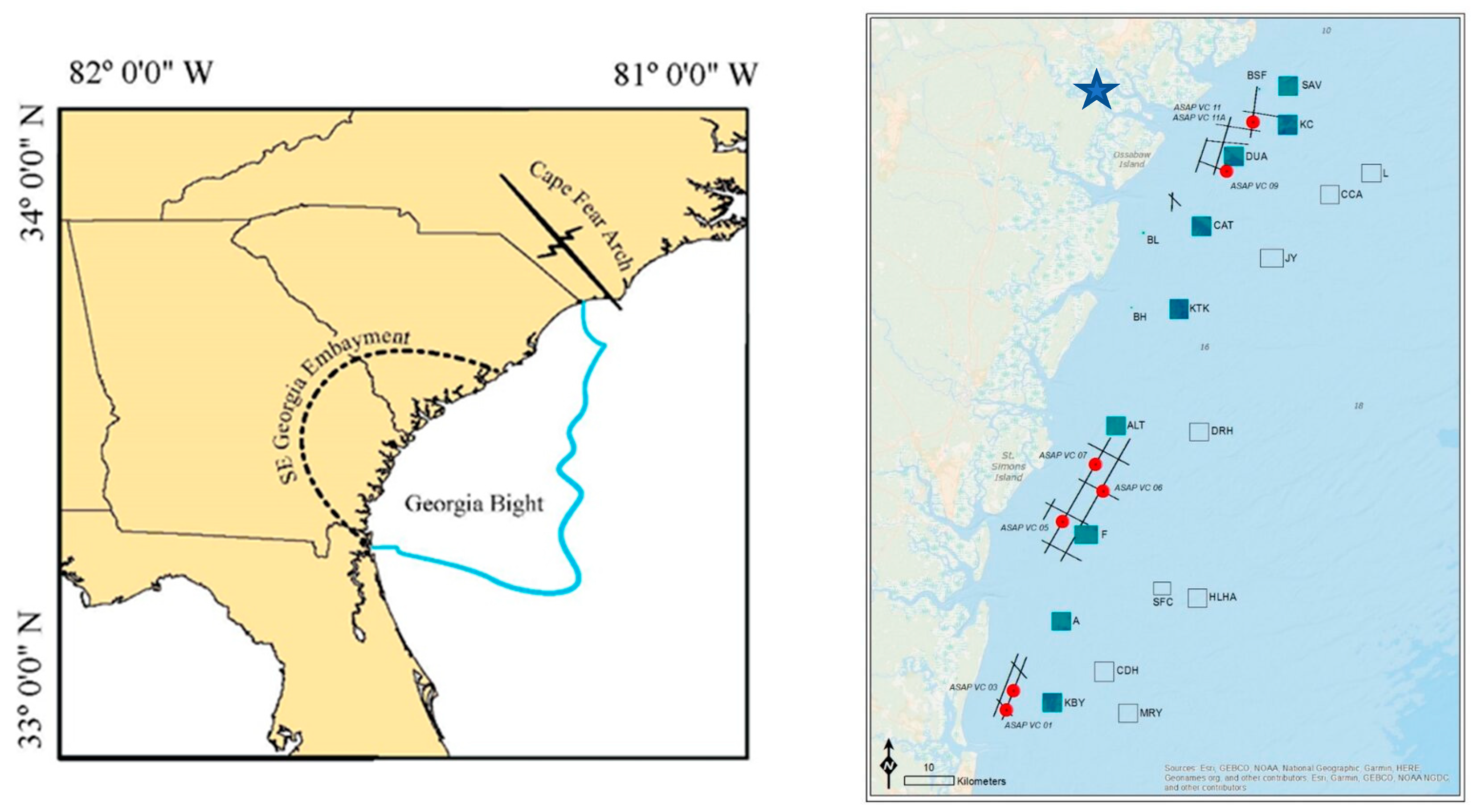
2.1. Geology of the Research Area
2.2. Methods
2.3. Sampling
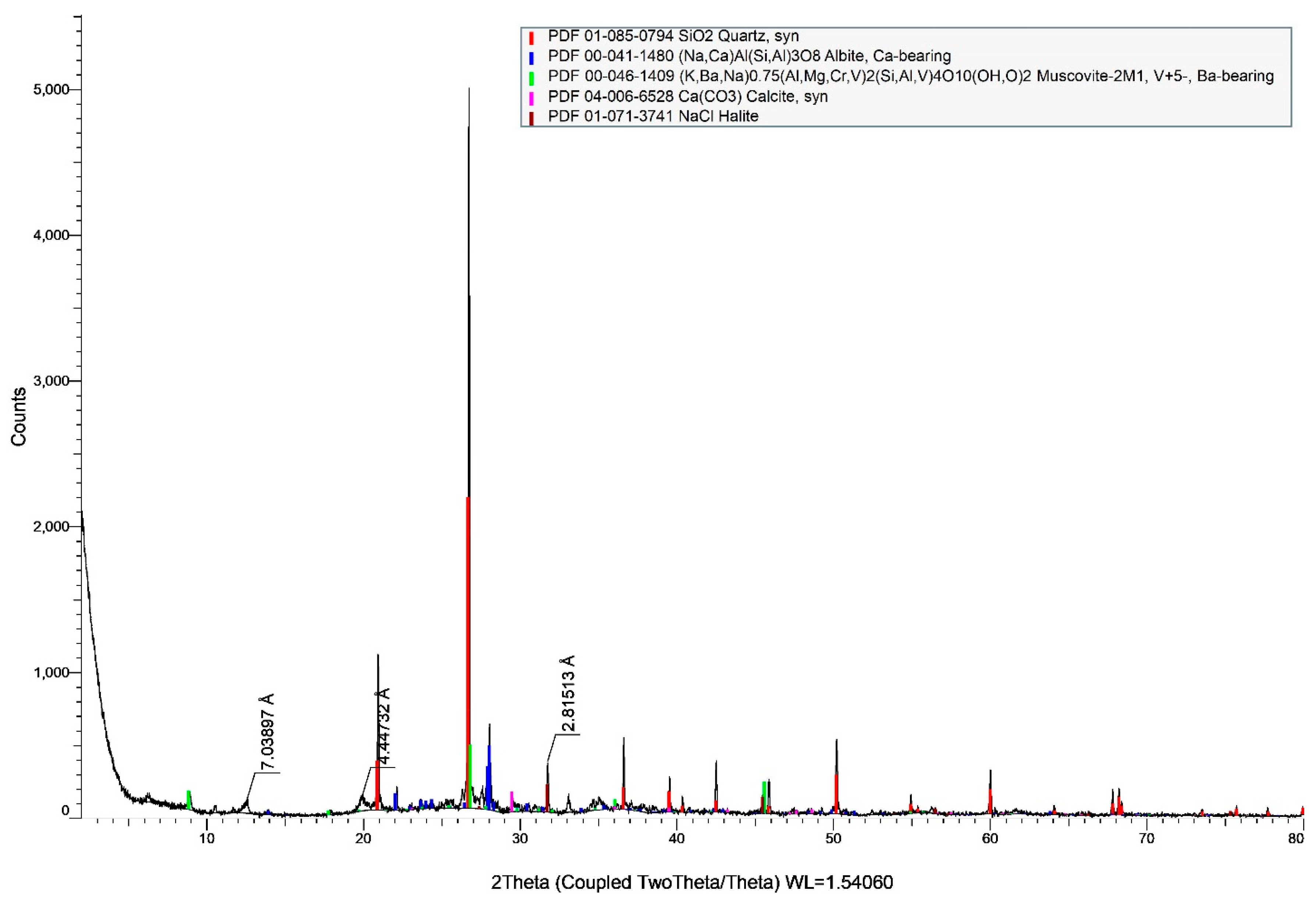
2.4. X-Ray Diffraction (XRD)
2.5. Microbotanical
2.6. Sedimentological
2.7. Chronological
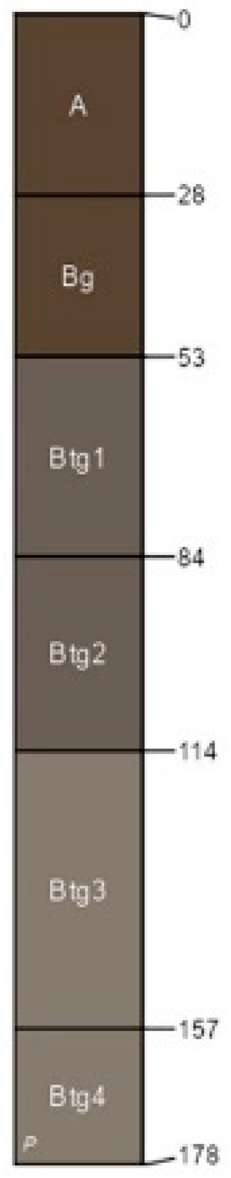
3. Results
4. Discussion
5. Conclusions
Author Contributions
Funding
Institutional Review Board Statement
Informed Consent Statement
Data Availability Statement
Acknowledgments
Conflicts of Interest
References
- Tsatskin, A.; Sandler, A.; Avnaim-Katav, S. Quaternary subsurface paleosols in Haifa Bay, Israel: A new perspective on stratigraphic correlations in coastal settings. Palaeogeogr. Palaeoclimatol. Palaeoecol. 2015, 426, 285–296. [Google Scholar] [CrossRef]
- Gusick, A.E.; Maloney, J.; Braje, T.J.; Retallack, G.J.; Johnson, L.; Klotsko, S.; Ainis, A.; Erlandson, J.M. Soils and terrestrial sediments on the seafloor: Refining Archaeological paleoshoreline estimates and paleoenvironmental reconstruction off the California coast. Front. Earth Sci. 2022, 10, 941911. [Google Scholar] [CrossRef]
- Tabor, N.J.; Myers, T.S. Paleosols as indicators of paleoenvironment and paleoclimate. Annu. Rev. Earth Planet. Sci. 2015, 43, 333–361. [Google Scholar] [CrossRef]
- Fedje, D.W.; Josenhans, H. Drowned forests and archaeology on the continental shelf of British Columbia, Canada. Geology 2000, 28, 99–102. [Google Scholar] [CrossRef]
- Lacourse, T.; Mathews, R.W.; Fedje, D.W. Late-glacial vegetation dynamics of the Queen Charlotte Islands and adjacent continental shelf, British Columbia, Canada. Palaeogeogr. Palaeoclimatol. Palaeoecol. 2005, 226, 36–57. [Google Scholar] [CrossRef]
- Harrison, W.; Lyon, C.J. Sea-level and crustal movements along the New England-Acadian shore, 4,500-3,000 BP. J. Geol. 1963, 71, 96–108. [Google Scholar] [CrossRef]
- Uścinowicz, S.; Miotk-Szpiganowicz, G.; Krąpiec, M.; Witak, M.; Harff, J.; Lübke, H.; Tauber, F. Drowned forests in the Gulf of Gdańsk (Southern Baltic) as an indicator of the Holocene shoreline changes. In The Baltic Sea Basin; Springer: Berlin/Heidelberg, Germany, 2011; pp. 219–231. [Google Scholar]
- Obelcz, J.; Hill, T.; Wallace, D. Geospatial Prediction of Preserved Submerged Paleo Forests on the Northern Gulf of Mexico Continental Shelf. In Proceedings of the AGU Fall Meeting Abstract 2021, New Orleans, LA, USA, 13–17 December 2021; Volume 2021, p. 44B-03. [Google Scholar]
- Obelcz, J.; Xu, K.; Gonzalez, S.; Bentley, S.J.; Caporaso, A.; DeLong, K.L.; Harley, G.L.; Reese, C.A.; Truong, J.T.; Dodd, D.; et al. Placing a Late Pleistocene Drowned Forest within the Geological Context of the Northern Gulf of Mexico via Seafloor and Shallow Subsurface Mapping. In Proceedings of the AGU Fall Meeting Abstracts 2016, San Francisco, CA, USA, 12–16 December 2016; Volume 2016, p. EP21E-08. [Google Scholar]
- Garrison, E.G.; Jones, E.C.; Robinson, M.; Rivera, Y.I.; Williams, K.A.; Prueitt, B.; Carter, A.L.; Newton, M.A.; Hemmings, C.A. “Scouring for Prehistory”—An Opportunistic Methodology for Sea Floor Archaeology. Heritage 2024, 7, 3417–3428. [Google Scholar] [CrossRef]
- Long, J.H.; Hanebuth, T.J.J.; Alexander, C.R.; Wehmiller, J.F. Depositional Environments and Stratigraphy of Quaternary Paleochannel Systems Offshore of the Georgia Bight, Southeastern U.S.A. J. Coast. Res. 2021, 37, 883–905. [Google Scholar] [CrossRef]
- Alexander, C. Geospatial Sand Resource Assessment for Georgia Coastal Recovery and Resiliency—Phase II; BOEM: Washington, DC, USA, 2019. [Google Scholar]
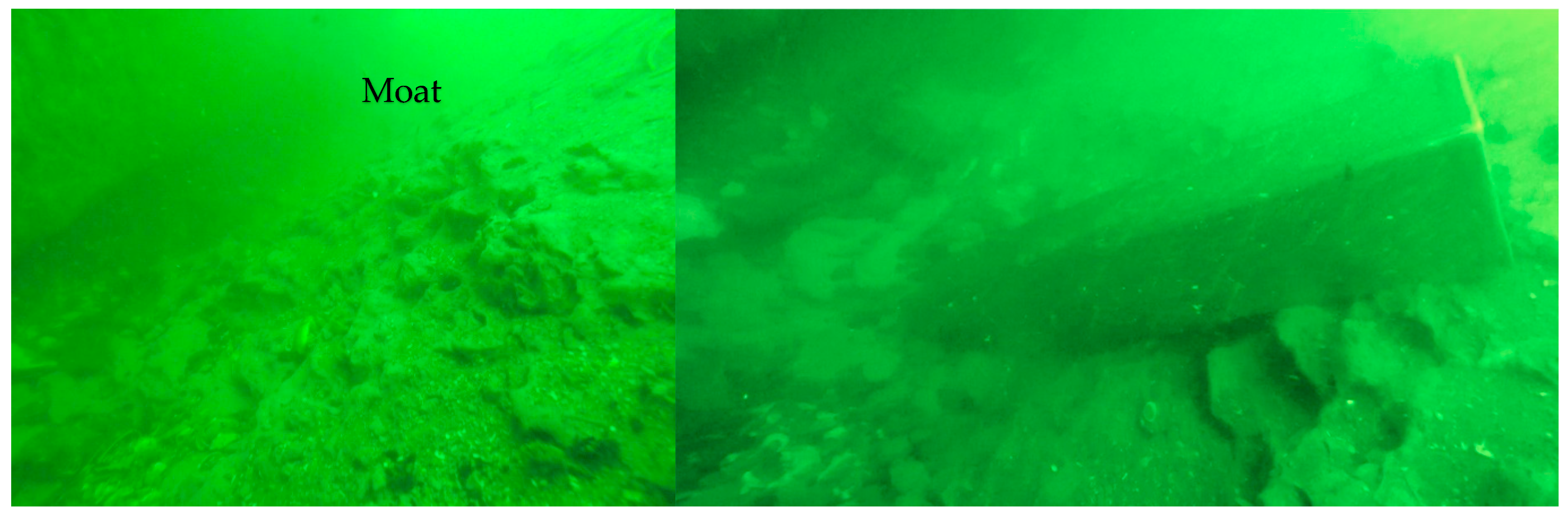
- Garrison, E.G.; Carter, A.L.; Jones, E.C.; Williams, K.A.; Rivera, Y.I.; Robinson, M.; Cronin, K.E. Moats & comets-A methodology to explore for submerged prehistory at sea floor erosional features formed at artificial reefs, Atlantic continental shelf, Georgia, USA. Quat. Sci. Rev. 2024, 334, 108725. [Google Scholar]
- Weems, R.E.; Edwards, L.E. Geology of Oligocene, Miocene and Younger Deposits in Coastal Georgia; Georgia Geologic Survey Bulletin 131; Department of Natural Resources, Environmental Protection Division: Atlanta, GA, USA, 2001; 124p. [Google Scholar]
- Weems, R.E.; Lewis, W.A. Structural and tectonic setting of the Charleston, South Carolina, region: Evidence from the Tertiary stratigraphic record. Geol. Soc. Am. Bull. 2002, 114, 24–42. [Google Scholar] [CrossRef]
- Harris, M.S.; Gayes, P.T.; Kindinger, J.L.; Flocks, J.G.; Krantz, D.E.; Donovan, P. Quaternary geomorphology and modern coastal development in response to an inherent geologic framework: An example from Charleston, South Carolina. J. Coast. Res. 2005, 211, 49–64. [Google Scholar] [CrossRef]
- Baldwin, W.E.; Morton, R.A.; Putney, T.R.; Katuna, M.P.; Harris, M.S.; Gayes, P.; Driscoll, N.W.; Denny, J.F.; Schwab, W.C. Migration of the Pee Dee River system inferred from ancestral paleochannels underlying the South Carolina Grand Strand and Long Bay inner shelf. Geol. Soc. Am. Bull. 2006, 118, 533–549. [Google Scholar] [CrossRef]
- Harding, J.L.; Henry, V.J., Jr. Geological History of Gray’s Reef National Marine Sanctuary; Report to the National Oceanic and Atmospheric Administration 10; Gray’s Reef National Marine Sanctuary: Savannah, GA, USA, 1994. [Google Scholar]
- Hunt, J.L. The Geology and Origin of Gray’s Reef, Georgia Continental Shelf. Master’s Thesis, University of Georgia, Athens, GA, USA, 1974. [Google Scholar]
- Garrison, E.G.; McFall, G.; Noakes, S.E. Shallow Marine Margin Sediments, Modern Marine Erosion and the Fate of Sequence Boundaries, Georgia Bight, U.S.A. Southeast. Geol. 2008, 45, 127–142. [Google Scholar]
- Garrison, E.G.; McFall, G.; Cherkinsky, A.; Noakes, S.E. Discovery of a Pleistocene mysticete whale, Georgia Bight (USA). Paleontol. Electron. 2012, 15, 31A. [Google Scholar] [CrossRef] [PubMed]
- Riggs, S.R.; Snyder, S.W.; Hine, A.C.; Mearns, D.L. Hardbottom morphology and relationship to the geologic framework: Mid-Atlantic Bight. J. Sediment. Res. 1996, 66, 830–846. [Google Scholar]
- Antoine, J.W.; Henry, V.J., Jr. Seismic refraction study of shallow part of continental shelf off Georgia coast. Am. Assoc. Pet. Geol. Bull. 1965, 49, 601–609. [Google Scholar]
- Foyle, A.M.; Henry, V.J., Jr.; Alexander, C.R. The Miocene Aquitard and the Floridian Aquifer of the Georgia/South Carolina Coast: Geophysical Mapping of Potential Seawater Intrusion Sites; Georgia Geologic Survey Bulletin 132; Georgia Department of Natural Resources: Atlanta, GA, USA, 2001; 78p. [Google Scholar]
- Swift, D.J.P.; Kofoed, J.W.; Saulsbury, F.P.; Sears, P. Holocene evolution of the shelf surface, central and southern shelf of North America. In Shelf Sediment Transport: Process and Pattern; Swift, D.J.P., Duane, D.B., Pilkey, O.H., Eds.; Dowden, Hutchinson and Ross: Stroudsburg, PA, USA, 1972; pp. 499–574. [Google Scholar]
- Swift, D.J.P. Coastal sedimentation. In Marine Sediment Transport and Environmental Management; Stanley, D.J., Swift, D.J.P., Eds.; John Wiley and Sons: Hoboken, NJ, USA, 1976; pp. 255–310. [Google Scholar]
- Woolsey, J.R.; Henry, V.J. Shallow, high resolution seismic investigations of the Georgia coast and inner continental shelf. Ga. Geol. Surv. Bull. 1974, 87, 167–187. [Google Scholar]
- Raineault, N.A.; Trembanis, A.C.; Miller, D.C.; Capone, V. Interannual changes in the seafloor surficial geology at artificial reef site on the inner continental shelf. Cont. Shelf Res. 2013, 58, 67–78. [Google Scholar] [CrossRef]
- Ramirez, I.O.; Galili, E.; Shahack-Gross, R. Locating submerged prehistoric settlements: A new underwater survey method using water-jet coring and micro-geoarchaeological techniques. J. Archaeol. Sci. 2021, 135, 105480. [Google Scholar] [CrossRef]
- Black, D.; Windover, D.; Mendenhall, M.; Henins, A.; Filliben, J.; Cline, J. Certification of Standard Reference Material 1976b. Powder Diffr. 2015, 30, 199–204. [Google Scholar] [CrossRef]
- Stockmarr, J. Tablets with spores used in absolute pollen analysis. Pollen Spores 1971, 13, 615–621. [Google Scholar]
- Traverse, A. Paleopalynology; Unwin-Hyman: Boston, MA, USA, 2007. [Google Scholar]
- Stuiver, M.; Reimer, P.J. CALIB rev. 8. Radiocarbon 1993, 35, 215–230. [Google Scholar] [CrossRef]
- Willard, D.; Bernhardt, C.; Brown, R.; Landacre, B.; Townsend, P. Development and application of a pollen-based paleohydrologic reconstruction from the Lower Roanoke River basin, North Carolina, USA. Holocene 2011, 21, 305–317. [Google Scholar] [CrossRef]
- Delong, K.L.; Gonzalez, S.; Obelcz, J.B.; Truong, J.T.; Bentley, S.J., Sr.; Xu, K.; Reese, C.A.; Harley, G.L.; Caporaso, A.; Shen, Z.; et al. Late Pleistocene bald cypress (Taxodium distichum) forest deposit on the continental shelf of the northern Gulf of Mexico. Boreas 2021, 50, 871–892. [Google Scholar] [CrossRef]
- Donahue, B.T.; Gayes, P.T.; Scott, D.B.; McCarthy, F.M.G. The late Pleistocene–early Holocene marine transition in South Carolina: An exposed forest floor on the SC mid-shelf. Abstr. Programs Geol. Soc. Am. 1995, 27, 202. [Google Scholar]
- Turck, J. Where were all the coastally adapted people during the Middle Archaic Period in Georgia, USA? J. Isl. Coast. Archaeol. 2012, 7, 404–424. [Google Scholar] [CrossRef]
- Ogasa, N. Geoscientists Found the Most Dangerous Part of a Famous West Coast fault. Science News, 13 July 2024. [Google Scholar]
- Hart, R.; Peterson, C. Late-Holocene buried forests on the Oregon Coast. Earth Surf. Process. Landf. 2007, 32, 210–229. [Google Scholar] [CrossRef]
- Gonzalez, S.; Bentley, S.J.; DeLong, K.L.; Xu, K.; Obelcz, J.; Truong, J.; Harley, G.L.; Reese, C.A.; Caporaso, A. Facies reconstruction of a Late Pleistocene cypress forest discovered on the northern Gulf of Mexico continental shelf. Gulf Coast Assoc. Geol. Soc. Trans. 2017, 67, 133–146. [Google Scholar]
- Peterson, C.D.; Stock, E.; Cloyd, C.; Beckstrand, D.; Clough, C.; Erlandson, J.; Gelfenbaum, G.; Hart, R.; Murillo, J.; Percy, D.; et al. Dating and Morphostratigraphy of Coastal Dune Sheets from the Central West Coast of North America; Oregon Sea Grant Publication ORESU-C-06-001; Oregon Sea Grant: Corvallis, OR, USA, 2006. [Google Scholar]
- DePratter, M.P. Variability Within Upper Shoreface Facies Seaward of Barrier Islands Within the Georgia Bight. Unpublished Master’s Thesis, The University of Georgia, Athens, GA, USA, 1991. [Google Scholar]
- Gorsline, D.S. Bottom sediments of the Atlantic shelf and slope off the southern United States. J. Geol. 1963, 71, 422–440. [Google Scholar] [CrossRef]
- Pilkey, O.H.; Frankenberg, D. The relict-recent sediment boundary on the Georgia continental shelf. Ga. Acad. Sci. Bull 1964, 22, 37–40. [Google Scholar]
- Henry, V.J., Jr.; Hoyt, J.H. Quaternary paralic and shelf sediments of Georgia. Southeast. Geol. 1968, 9, 195–214. [Google Scholar]
- Garrison, E.G. Sea-Level Evidence for a Significant Reduction of the Laurentide Ice Sheet in MIS 3, Georgia Bight, Southeastern United States. J. Coast. Res. 2023, 39, 836–847. [Google Scholar] [CrossRef]


| UGAMS# | Sample ID | Material | δ13C, ‰ | 14C Age Years, BP | ± | pMC | ± |
|---|---|---|---|---|---|---|---|
| 64367 | Barge 6 | wood | −26.16 | 49,670 | 420 | 0.21 | 0.01 |
| 64368 | Barge 13 | wood | −25.48 | 40,800 | 180 | 0.62 | 0.01 |
| 67126 | Barge 13 | wood | −24.59 | 37,560 | 220 | 0.93 | 0.02 |
| 70559 | Barge 13 | wood | −26.72 | 39,710 | 200 | 0.71 | 0.02 |
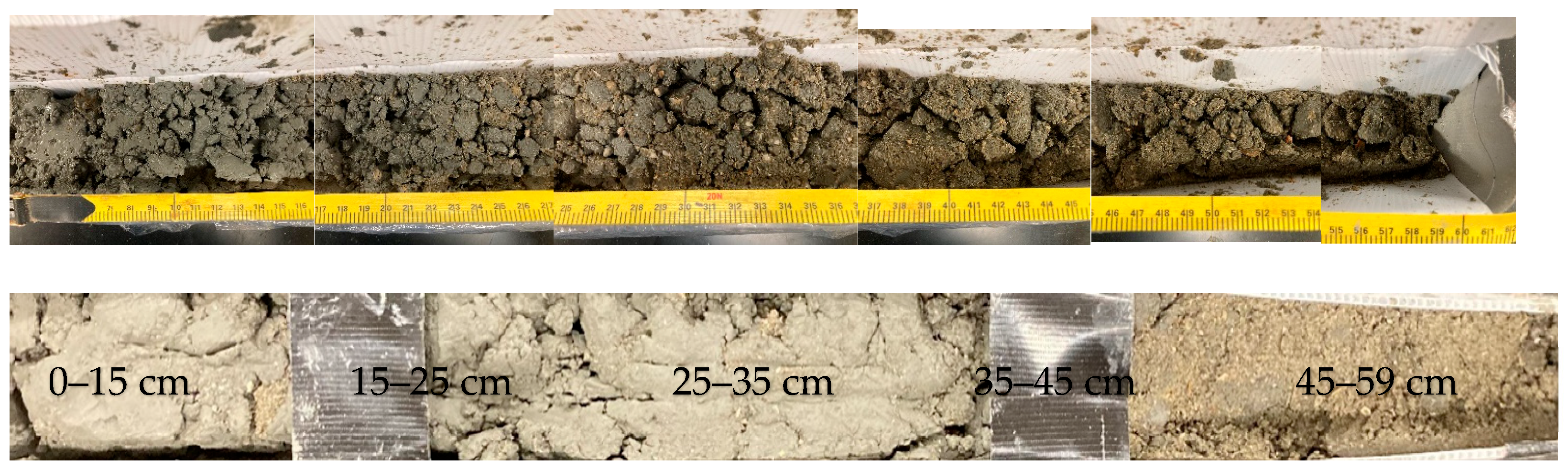
| Paleosol | Thickness | Munsell Color (Dry) | Loss on Ignition (%) | Sand (%) | Silt (%) | Clay (%) | Clay (XRD) | Fe (%) | Mn (%) | CaCo3 (%) |
|---|---|---|---|---|---|---|---|---|---|---|
| Barge 13 | >1 m | 10YR6/1 | 5 | 66.9 | 11.5 | 21.6 | smectite | 0–6 | 0 | 0–8 |
| Modern Vegetation Type | Taxon | Shallow Auger Clay Soil Horizon | Middle Auger Clay Soil Horizon |
|---|---|---|---|
| Southeastern conifer-hardwood forests | Percent Abundance | ||
| Pinus (pine) | 63 | 63 | |
| Quercus (oak) | 9 | 12 | |
| Carya (hickory) | 7 | 7 | |
| Other hardwoods | 2 | 2 | |
| Cool-temperate forests | Picea (spruce) | 3 | 1 |
| Abies (fir) | 1 | 0 | |
| Tsuga (hemlock) | 1 | 0 | |
| Fagus (beech) | 2 | 3 | |
| Forested wetlands | Taxodium (cypress) | 1 | 1 |
| Nyssa (tupelo, gum) | 1 | 1 | |
| Herbaceous plants | Herbaceous angiosperms | 3 | 6 |
| Lower vascular plants | 2 | 1 | |
Disclaimer/Publisher’s Note: The statements, opinions and data contained in all publications are solely those of the individual author(s) and contributor(s) and not of MDPI and/or the editor(s). MDPI and/or the editor(s) disclaim responsibility for any injury to people or property resulting from any ideas, methods, instructions or products referred to in the content. |
© 2025 by the authors. Licensee MDPI, Basel, Switzerland. This article is an open access article distributed under the terms and conditions of the Creative Commons Attribution (CC BY) license (https://creativecommons.org/licenses/by/4.0/).
Share and Cite
Garrison, E.G.; Newton, M.A.; Prueitt, B.; Jones, E.C.; Willard, D.A. Discovery of an Intact Quaternary Paleosol, Georgia Bight, USA. Appl. Sci. 2025, 15, 6859. https://doi.org/10.3390/app15126859
Garrison EG, Newton MA, Prueitt B, Jones EC, Willard DA. Discovery of an Intact Quaternary Paleosol, Georgia Bight, USA. Applied Sciences. 2025; 15(12):6859. https://doi.org/10.3390/app15126859
Chicago/Turabian StyleGarrison, Ervan G., Matthew A. Newton, Benjamin Prueitt, Emily Carter Jones, and Debra A. Willard. 2025. "Discovery of an Intact Quaternary Paleosol, Georgia Bight, USA" Applied Sciences 15, no. 12: 6859. https://doi.org/10.3390/app15126859
APA StyleGarrison, E. G., Newton, M. A., Prueitt, B., Jones, E. C., & Willard, D. A. (2025). Discovery of an Intact Quaternary Paleosol, Georgia Bight, USA. Applied Sciences, 15(12), 6859. https://doi.org/10.3390/app15126859