Article

Optimizing Parcel Locker Selection in Campus Last-Mile Logistics: A Path Planning Model Integrating Spatial–Temporal Behavior Analysis and Kernel Density Estimation

by
Hongbin Zhang
1,
Peiqun Lin
1,* and
Liang Zou
2
1
School of Civil Engineering and Transportation, South China University of Technology, Guangzhou 510641, China
2
College of Civil and Transportation Engineering, Shenzhen University, Shenzhen 518060, China
*
Author to whom correspondence should be addressed.
Appl. Sci. 2025, 15(12), 6607; https://doi.org/10.3390/app15126607
Submission received: 12 April 2025 / Revised: 30 May 2025 / Accepted: 5 June 2025 / Published: 12 June 2025

Abstract

The last-mile delivery crisis, exacerbated by the surge in e-commerce demands, continues to face persistent challenges. Logistics companies often overlook the possibility that recipients may not be at the designated delivery location during courier distribution, leading to interruptions in the delivery process and spatiotemporal mismatches between couriers and users. Parcel lockers (PLCs), as a contactless self-pickup solution, mitigate these mismatches but suffer from low utilization rates and user dissatisfaction caused by detour-heavy pickup paths. Existing PLC strategies prioritize operational costs over behavioral preferences, limiting their real-world applicability. To address this gap, we propose a user-centric path planning model that integrates spatiotemporal trajectory mining with kernel density estimation (KDE) to optimize PLC selection and conducted a small-scale experimental study. Our framework integrated user behavior and package characteristics elements: (1) Behavioral filtering: This extracted walking trajectories (speed of 4–5 km/h) from 1856 GPS tracks of four campus users, capturing daily mobility patterns. (2) Hotspot clustering: This identified 82% accuracy-aligned activity hotspots (50 m radius; ≥1 h stay) via spatiotemporal aggregation. (3) KDE-driven decision-making: This dynamically weighed parcel attributes (weight–volume–urgency ratio) and route regularity to minimize detour distances. Key results demonstrate the model’s effectiveness: a 68% reduction in detour distance for User A was achieved, with similar improvements across all test subjects. This study enhances last-mile logistics by integrating user behavior analytics with operational optimization, providing a scalable tool for smart cities. The KDE-based framework has proven effective in campus environments. Its future potential for expansion to various urban settings, ranging from campuses to metropolitan hubs, supports carbon-neutral goals by reducing unnecessary travel, demonstrating its potential for application.

1. Introduction

According to the National Bureau of Statistics of China, in 2024, the volume of express deliveries in China surpassed 170 billion, representing a 21% increase from the previous year. The burgeoning volume of logistics in China has exerted substantial pressure on terminal distribution, particularly due to the temporal and spatial mismatches between delivery personnel and recipients [1]. Consequently, within the domain of logistics delivery, ensuring timely and accurate parcel distribution in the last mile remains a persistent challenge in this critical phase. Parcel lockers (PLCs), characterized by their innovative “distribution and self-pickup” paradigm, have emerged as a pivotal solution to mitigate the temporal constraints between courier services and recipients [2], by reducing delivery time to enhance the convenience of user pickup [3], and are highly favored by both delivery companies and recipients [4]. This model not only alleviates the strain on terminal distribution but also capitalizes on its contactless delivery feature, which was instrumental during the COVID-19 pandemic [5].
Notably, data indicates that the deployment of PLCs in China surged to 2 million units in 2021, marking a staggering year-over-year growth of 159.07%. As the number of parcel lockers (PLCs) grows, the density of these lockers within urban spaces increases, and their distribution expands throughout urban areas. Consequently, facilitating efficient user path planning to optimize parcel locker location selection is becoming increasingly important. Existing PLC strategies prioritize operational costs over behavioral preferences, limiting their real-world applicability, and tracking user needs and dynamically planning user paths to determine the optimal PLC location is a highly practical trend [6]. Research suggests that users prefer the convenience of self-pickup along their regular routes [7]. This indicates that users who collect their packages via their regular paths can increase their satisfaction and willingness to use the parcel lockers. However, in the context of smart cities, developing user-centric PLC location selection methods faces dual challenges: user paths are influenced by dynamic preferences (such as detour willingness) and external constraints (such as time windows), resulting in uncertainty; PLC deployment requires balancing facility costs, capacity limitations, and service coverage rates.
This study aims to address the following core issues: (1) how to extract regular activity hotspots from user spatiotemporal trajectories and quantify their correlation with PLC site selection; (2) how to dynamically integrate parcel physical attributes (weight–volume–urgency) into route planning decisions; (3) how to balance user convenience with logistics resource utilization through algorithmic design.
Consequently, this paper proposes a user-centric path planning model that integrates kernel density estimation (KDE) and spatiotemporal behavior analysis techniques to optimize parcel locker location selection decisions in campus scenarios. The main findings are as follows:
(1) Spatiotemporal behavior analysis-based KDE modeling reduces users’ detour distance for package pickup by an average of 68% (case of User A), demonstrating the optimization potential driven by behavioral data. (2) The package urgency parameter (α) significantly influences PLC selection strategy, with users tending to sacrifice distance for timeliness in high-urgency scenarios (α ≥ 3). (3) The model maintains stability in synthetic city-level data, indicating its scalability.
The contributions of this study include innovatively embedding user spatiotemporal behavior and package attributes into the KDE framework, breaking through the static assumptions of traditional location selection models. Its practical value includes providing technical pathways for “last-mile” low-carbon solutions (reduced detours = lower carbon emissions) and personalized services. The proposed methodology framework holds potential for diverse applications across urban logistics and public services, such as smart city logistics, personalized e-commerce delivery, multimodal transportation integration, autonomous delivery ecosystems, emergency response systems, and carbon-neutral urban planning, among others.
The full-text structure is as follows: Section 2 reviews last-mile logistics solutions, critically analyzes the limitations of PLC research, and positions the interdisciplinary value of this study; Section 3 proposes a three-stage methodological framework, including trajectory filtering, hotspot clustering, and KDE optimization; Section 4 validates model performance through empirical data, compares baseline methods, and tests scalability; Section 5 discusses the theoretical implications, practical limitations, and future directions of the findings; Section 6 summarizes the conclusions and prospects its application potential in smart cities and emergency logistics.

2. Literature Review

Existing studies on last-mile parcel locker (PLC) location optimization have primarily focused on operational factors. However, these approaches often overlook the critical role of user behavior in determining optimal locker placements. While prior work has established frameworks for minimizing logistical costs or maximizing coverage areas, the integration of dynamic user preferences—particularly spatiotemporal mobility patterns—remains underexplored. The following subsections critically analyze these methodologies, highlighting their strengths and limitations, while positioning the current study’s novel integration of spatiotemporal user trajectories as a response to these gaps.

2.1. Last-Mile Distribution Solution

The complexity of last-mile logistics [8] has given rise to diverse solutions, including home delivery, crowdsourcing logistics, drone delivery, and parcel lockers (PLCs) [9]. Among these, home delivery is a relatively straightforward method, yet frequent delivery interruptions occur due to recipients’ absence. Crowdsourcing logistics optimizes resource allocation through the sharing economy but relies heavily on social trust and exhibits significant service quality fluctuations [10]. Drone delivery is suitable for remote areas but faces regulatory constraints and payload limitations [11]. Compared to other last-mile delivery solutions, parcel lockers (PLCs) offer a “contactless self-pickup” model that balances cost and delivery convenience, demonstrating unique advantages particularly in high-density urban areas [6,12,13,14]. However, when parcel lockers cannot yet autonomously move or deliver users to PLCs via autonomous driving, enhancing user convenience significantly improves satisfaction with this delivery method [15]. Existing PLC research predominantly focuses on static facility location selection while neglecting the dynamics of user behavior, resulting in a disconnect between theory and practice [16,17].

2.2. Optimization of Parcel Locker Location Selection

The location of PLCs is influenced by factors such as availability, accessibility, security, environmental impact, site occupancy, cost, usage methods, regulations, and others [7,18]. Previous studies on optimizing the site selection of PLCs have thoroughly discussed the environmental impact, the optimal time window for distribution, the cost-efficiency of distribution, and the sensitivity of users’ pickup distance to the selection of PLCs [19,20,21]. Despite significant progress in PLC location optimization, its limitations still constrain practical applications:
(1) Neglect of user behavior: Most studies aim at cost minimization or coverage maximization without integrating spatiotemporal trajectory data to enhance efficiency.
(2) Static assumption bias: Traditional models presume fixed demand distributions, overlooking time-varying user activity patterns (e.g., commuting tidal effects), exacerbating spatiotemporal mismatches.
(3) Excessive parameter simplification: Current KDE applications are largely confined to spatial dimensions, failing to couple parcel physical attributes (e.g., weight–volume–urgency) and limiting decision-making granularity. These shortcomings highlight the need to develop a dynamic, user-centric, and multi-parameter collaborative PLC location framework.
With the advancement of mobile terminals, apps, and geographic information technology, it is now possible to leverage user spatiotemporal trajectories to select suitable PLCs, thereby improving user convenience [12,22,23].

2.3. User Preferences and Logistics Path Planning

There is a significant gap between the courier services available for last-mile delivery and consumers’ preferences for these services [24]. The effort required for social interaction deters consumers from opting for manned delivery methods, making unattended alternatives—such as home delivery and self-pickup—even more appealing [25]. To enhance user accessibility, it is necessary to develop corresponding positioning strategies during the delivery process, integrating user preferences with the selection of self-service lockers. User behavior preferences are closely related to spatial–temporal trajectories, which contain a wealth of information about user travel preferences, including spatial characteristics, temporal sequences, and other external descriptive attributes [26]. Thus, trajectory data is extensively used across various domains, including the identification of user hotspots, the recommendation of optimal routes, and the suggestion of points of interest [27,28,29]. The integration of user behavior patterns into logistics planning is not new, but their application to PLC selection is relatively underexplored. Studies have shown that individuals exhibit regular and predictable spatiotemporal behavior, which can be harnessed to improve the efficiency of parcel locker usage [2]. This study integrates behavioral geography and operations research, conceptualizing users’ spatiotemporal trajectories as a “dynamic demand field,” thereby innovatively expanding the application boundaries of KDE in the logistics domain. Specifically:
Contribution from Geography: Through activity hotspot clustering, the spatial anchor points and path dependency characteristics of user behavior can be revealed, forming a methodological complement to the trajectory recommendation algorithm proposed by Pan et al. (2021) [26].
Contribution from Operations Research: A multi-objective optimization model is constructed to simultaneously balance distance, time, and parcel attributes, overcoming the limitations of traditional single-objective models (e.g., Chen et al., 2015) [20].
This interdisciplinary framework establishes a new paradigm for “human-centric logistics,” bridging the theoretical gap between behavioral analysis and facility optimization.

2.4. Application of Kernel Density Estimation Method

Kernel density estimation (KDE) is widely applied in spatiotemporal behavior analysis due to its adaptability and robustness to noise in datasets and is often used in the fields of transportation planning and logistics path planning [30,31,32,33]. KDE’s capacity to manage multi-dimensional data and its non-parametric nature make it an ideal tool for standardizing data and identifying patterns in user travel behavior [34,35,36]. Our research applies kernel density estimation (KDE) to transform time–space distances, weight, volume restrictions, and urgency into density values, which are then utilized to identify regular activity hotspots and optimize parcel locker (PLC) selection.
In summary, the literature highlights the need for innovative solutions in last-mile logistics that consider both user convenience and operational efficiency. Our study contributes to this field by incorporating user spatiotemporal behavior with kernel density estimation (KDE) to optimize parcel locker selection, addressing a gap in the current literature and presenting a practical approach to enhancing last-mile logistics.

3. Methodology

3.1. Problem Description

When selecting a parcel locker system, adopting a user-centric perspective requires addressing both the “temporal gap” and “spatial gap” between users and couriers. This necessitates analyzing constraints such as travel distance, time efficiency, and package dimensions (weight/volume/urgency) throughout the research process. The dataset includes users’ spatiotemporal movement patterns alongside detailed cargo specifications. By evaluating temporal and spatial factors, we can cluster travel behaviors geographically to identify hotspot distributions, while simultaneously integrating users’ preferences for en-route package retrieval into the final locker selection strategy. For this purpose, we collected the travel trajectories of four campus users and conducted a small-scale empirical analysis.

3.2. Research Approach

(1) Pedestrian Trajectory Extraction:
Data Source: Trajectory data, which includes longitude, latitude, time, altitude, and speed, was collected using GPS-enabled mobile terminals (Wristband, Smartwatch, phone, etc.) at a frequency of 5 s from four students at Shenzhen University. The participants were selected based on their daily commuting patterns within the Nanshan District of Shenzhen, China.
Data Scope: The dataset spans a 3-month period (January–March 2023), covering 13 parcel lockers (PLCs) and key urban areas, including academic buildings, dormitories, and commercial zones. Each user contributed approximately 15–20 walking trajectories per week, resulting in a total of 1856 trajectories (mean length: 1.2 km per trajectory).
Filtering Criteria: Walking trajectories were extracted by applying a speed threshold of 4–5 km/h (average pedestrian speed) [37]. Trajectories exceeding 5 km/h were discarded to exclude non-walking activities (e.g., cycling or vehicular movement). Figure 1a,b illustrate raw and filtered trajectories, respectively. At the same time, during the data filtering process, different traffic modes can also be incorporated based on speed thresholds.
(2) Identifying Activity Hotspots:
Hotspot Definition: Activity hotspots were defined as spatially aggregated regions [38] (radius: 50 m) where users stayed for ≥1 h (temporal threshold). This dual constraint (distance: L = 50 m; time: M = 720; 3600 s) ensured that hotspots reflected meaningful information.
Validation: Hotspots were validated against ground-truth POIs (points of interest, e.g., cafeterias, libraries) using OpenStreetMap data. For instance, 82% of identified hotspots aligned with known high-activity zones (e.g., the university library).
Data Volume: The initial dataset included 24 to 36 hotspots per user (e.g., User A had 24 hotspots). Following the filtering process, 2 to 5 consistent hotspots per user were kept for PLC selection. Figure 2a,b illustrate the identification of hotspots before and after clustering.
(3) Activity Hotspot Screening: To facilitate en-route goods pick-up, the activity hotspot screening process initially establishes whether the hotspots in the chain include the delivery point. It then assesses whether the user’s walking trajectory data represents their regular path and extracts the trajectory that includes the delivery point. Subsequently, it filters out previous hotspots and the spatiotemporal trajectory leading to the delivery point. The screening of activity hotspots before and after is depicted in Figure 3a,b.
(4) Regular Activity Hotspot Selection: Selecting PLCs requires identifying the user’s regular activity hotspot as the starting point for pick-up, as the previous hotspot location before the delivery point is unavailable. The selection considers temporal and spatial distances, using kernel density estimation to convert these distances into values for hotspot identification. The chosen hotspot is located at the light ring in Figure 4a.
(5) Parcel Locker Selection: After identifying the regular activity hotspot, the parcel locker is chosen based on its proximity to both the activity hotspot and the delivery point. The selection process takes into account the distance and time, integrating the weight, volume, and urgency restrictions of the express delivery into the decision-making. The parcel locker with the highest kernel density estimation value is selected as the final location, as depicted in Figure 4b with “PLCs Selected R2”.

3.3. Path Planning Model

3.3.1. Model Assumptions

(1) The calculation of distance employs spherical distance and does not account for factors such as urban road networks and building density. (2) The analysis area is treated as a two-dimensional homogeneous space, without considering the impact of urban facilities. (3) The position of the parcel locker is fixed, meaning that it is determined before the courier delivers the parcel. (4) The trajectory data is derived from the user’s walking data; by setting a speed threshold, transportation methods such as cycling and driving are excluded. The extraction of walking trajectories does not consider indoor activities, such as data loss from GPS signals within buildings like the teaching building, and determines whether the location is an activity hotspot based on the user’s dwell time in signal-deprived buildings within the trajectory data.

3.3.2. Variable Definitions

C represents the number of user-recorded walking trajectories;
C represents the number of filtered hotspot chains;
N c represents the total number of position information in the c user’s walking trajectory, where c = 1 , , C ;
M is repressed as the judgment standard of the user activity hotspot;
w c i represents the location information recorded by the user in track i , in walking trajectory c ;
t c i represents the time information recorded by the user in article i of the article c walking track;
L represents the spatial distance threshold between points (the threshold is set to 50 m);
γ is the distance constraint indicating whether a hotspot is a receiving point;
L ( w 1 , w 2 ) represents the spherical distance between position points w 1 and w 2 ;
T d ( w 1 , w 2 ) represents the temporal distance between position points w 1 and w 2 ;
w ¯ ( c , i , n ) represents the average position information of the user’s c trace from i to No ( i + n 1 );
X Z indicates the receiving point location information completed by the user;
R represents the number of PLCs;
K represents the number of user activity hotspots;
K s indicates the number of active hotspots after excluding the receive point hotspot;
w r represents the location information of the r PLC, where r = 1 R ;
X c k represents the location information of the k activity hotspot of the user’s article c walking track, where c = 1 C , k = 1 K ;
Y c k represents the entry time information of the k activity hotspot of the user’s article c walking trajectory, where c = 1 C , k = 1 K ;
T c k represents the residence time information of the k activity hotspot of the user’s article c walking track, where c = 1 C , k = 1 K ;
R T W represents the ratio of the express weight to the maximum load of the PLC weight;
R T V represents the ratio of the express volume to the maximum capacity of PLCs;
R T W V represents the express delivery weight–volume–urgency ratio;
α represents the urgency parameter for parcel delivery;
H c k is the decision variable indicating whether or not an activity hotspot is selected;
H r is the decision variable indicating whether to choose a PLC.

3.3.3. Hotspot Identification

Activity Hotspot Identification: By iterating through trajectory points, the degree of aggregation of these points serves as the criterion for determining the user’s activity hotspots. F c , i represents the degree of aggregation of the i point and subsequent points in the c user’s walking trajectory, and its calculation formula is as shown in Formula (1). When F c , i > M , it is considered that point i and subsequent points form a hotspot area, the centroid of which is the activity hotspot k , with the position information X c k and time information including the arrival time and stay time represented by Y c k and T c k , respectively; the previous trajectory and corresponding time are G W c k and G T c k , respectively.
F c , i = j = i N c ( k = i + 1 j I ( c , i , k ) )
F ( c , i ) represents the number of location points that satisfy the distance constraint near i , where I ( c , i , n ) indicates i + n and the average location information recorded from i to ( i + n 1 ) . The calculation formula is shown in Equation (2).
I c , i , n = 0 , L w ¯ c , i , n , w c i + n > L 1 , L w ¯ c , i , n , w c i + n L
w ¯ c , i , n represents the center of gravity of the subsequent i point positions of point n , and the calculation formula is shown in Equation (3).
w ¯ c , i , n = 1 n j = i i + n 1 w c j

3.3.4. Activity Hotspot Screening

By identifying hotspots, the user tracking chain is transformed into an active hotspot chain. To realize the route for cargo pickup, it is necessary to minimize the impact of unconventional travel behavior on the selection results. The method involves determining whether the hotspots in the hotspot chain include the receiving points. If they do not, the hotspot chain will be discarded. If they do, the hotspot chain will be extracted to extract the active hotspots and walking track, the remaining C hotspot chain, and the K s active hotspots. Furthermore, the time T c k before the hotspot X c k reaches the hotspot in the corresponding hotspot chain is the time set G T c k , where c = 1 C , k = 1 K S .

3.3.5. Regular Activity Hotspot Selection

In this paper, the sub-hotspot chain composed of the receiving point and the previous hotspot is taken as the passing path from the user to the receiving point. However, the preordered hotspots and path of the receiving point on the hotspot chain are not all regular hotspots and paths of the user, so in order to determine the starting point of the passing path, it is necessary to determine the regular activity hotspot of the user. In this paper, ee periodically update the regular activity hotspots by considering the time–space distance to other activity hotspots and receiving points and standardize this distance using the kernel density function. When users’ travel patterns and hotspot locations change, updates are made through the KDE framework. Therefore, the regular activity hotspot selection model is constructed as in Equation (4) and finally selects the hotspot φ .
M A X ( P ) = c = 1 C k = 1 K s H c k ( p d c k + p t c k + p z c k )
0 < L h
0 < D T 86,400
0 < c < C
0 < K s < K
c = 1 C k = 1 K s H c k = 1
H c k = 0 , Not   a   regular   activity   hotspot 1 , regular   activity   hotspot c C , k K s
P = c = 1 C k = 1 K s H c k ( p d c k + p t c k + p z c k )
where p d c k represents the spatial kernel density estimate between active hotspots (the calculation formula is shown in Equation (12)); p t c k represents the time kernel density estimate between active hotspots (the calculation formula is shown in Equation (15)); and p z c k represents the kernel density estimate of active hotspots and the user receiving point, and the calculation formula is shown in Equation (16).
p d c k = 1 K s h 2 i = 1 C j = 1 K s 1 2 π e 1 2 L ( X c k , X i j ) 2 h 2
where L ( X c k , X i j ) represents the spatial distance between the hotspot X c k and the hotspot X i j , and the calculation formula is
L ( X c k , X i j ) = γ a r c c o s ( ε )
ε = sin β sin β cos α α + cos β c o s ( β )
where γ represents the radius of the Earth, α , α indicates the angular value of the hotspot X c k ,   X i j is the longitude transformation, β , β indicates the angle value of X c k , and X i j is the position latitude transformation.
p t c k = 1 K s h 2 i = 1 C j = 1 K s 1 2 π e 1 2 T d ( Y c k , Y i j ) 86,400
where T d ( Y c k , Y i j ) represents the Euclidean distance between the hotspot Y c k and the hotspot time Y i j .
p z ( c k ) = 1 2 h 2 1 2 π e 1 2 L X c k , X z 2 h 2

3.3.6. PLC Selection

The kernel function, the spatial distance between the PLCs and the regular activity hotspot φ , the spatial distance from the receiving point, the weight–volume–urgency ratio of the express delivery, and other factors are included in the PLC selection decision. In the process of logistics distribution, we should not only consider whether the user’s path is along the way, because the goods are divided into heavy goods and bubble goods, and the PLCs also have the limits of weight and volume, so the characteristics of delivery goods should also be considered. This study innovatively harnesses the inherent properties of kernel density estimation to seamlessly integrate the distinctive parcel characteristics into the estimation framework. In order to better incorporate these influencing factors into the PLC selection decision, this paper constructs the PLC selection model as shown in Formula (17) by reconstructing the kernel function and finally selects the PLCs r .
M A X ( P ) = r = 1 R H r ( p r r + p z r )  
s . t . 0 < L h
0 < T d 86,400
0 < R T W 1
0 < R T V 1
r = 1 R H r = 1   r R
H r = 0 ,   N o t   a   R e g u l a r   s e l f l i f t   c a b i n e t 1 ,   R e g u l a r   s e l f l i f t   c a b i n e t   r R
P = p r r + p z r
where p r r represents the kernel density estimate of the PLC and hotspots, and the calculation formula is shown in Equation (25); p z r represents the estimated spatial kernel density value of the PLC and receiving point, and the calculation formula is shown in Equation (26).
p r r = 1 2 h 2 1 2 π e 1 2 L w φ , w r 2 h 2
where D w φ , w r represents the spatial distance of the PLC r from the selected active hotspot.
p z r = 1 2 h 2 1 2 π e 1 2 L ( W r , X Z ) 2 h 2 * R T W V
where R T W V represents the weight–volume–urgency ratio, and the calculation formula is shown in Equation (27). R T W and R T V represent the ratios of the weight and volume of express packages to the limit values of the weight and volume of the parcel locker, to ensure that selected PLCs can accommodate the physical dimensions of parcels, aligning with the practical limitations of self-collection facilities. α represents the urgency of parcel delivery.
R T W V = R T W + R T V α ; R T W , R T V ( 0,1 ]
In the above, R T W represents the ratio of the express weight to the weight of the maximum load of the PLC, and R T V represents the ratio of the express volume to the maximum capacity of the PLCs.

3.4. Data Acquisition and Model Parameter Settings

In this study, the Nanshan District of Shenzhen University in Shenzhen was chosen as the research area. The travel space–time trajectory data of four students and the location information of 13 PLCs within the test area were collected as the experimental data. Data collection employed an Amazfit smartwatch (Manufacturer: Zepp Health Corporation, Beijing, China, version: balance) equipped with a GPS module to capture the spatial and temporal location information of the students at a frequency of once every 5 s, as shown in Figure 5. The test data encompassed the longitude, latitude, speed, and time of the user’s travel process, along with the longitude and latitude of the PLCs and the receiving points. The data processing, model construction, path planning solution, and visualization in this study were all implemented using Python3.8. It is important to note that the four volunteers in this study can hardly represent the entire population or all types of activity spaces. However, the study relied on terminal devices to record individual trajectories, and such information contains a wealth of personal data that is often difficult to collect. Furthermore, the primary focus of this research is on the innovative value of the methodology. Similarly, Su and Li et al. also collected trajectory activity data from only four volunteers to measure individual activity exposure to physical neighborhood environments in their study [39,40].
To ensure the reliability and validity of the data, trajectory data was collected using pre-calibrated mobile devices with a positioning accuracy of ±10 m. Prior to the experiment, participants underwent standardized training to ensure proper device usage, such as avoiding signal obstruction, and device status was checked daily during data collection. A sliding window method with a window size of 10 data points was employed to detect and remove abnormal trajectory points, such as those with speeds greater than 5 km/h or sudden altitude changes exceeding 50 m. The data underwent spatiotemporal consistency validation by matching user-reported daily activity locations, such as dormitories and cafeterias, with GPS trajectories, achieving a matching accuracy of 98.7%. Hotspot locations were reverse-geocoded using the GaodeMap API(Web API service) to ensure alignment with actual points of interest (POIs), such as libraries and teaching buildings. Two independent clustering analyses, K-means and DBSCAN, were performed on user activity hotspots, yielding a clustering consistency index (Adjusted Rand Index) of 0.95, indicating high methodological reproducibility.
This study selected trajectory data from four users within a relatively enclosed campus environment as a preliminary exploration, primarily based on the following considerations: (1) Behavioral consistency: Campus users (students) exhibit highly regular daily activities (e.g., the dormitory–classroom–canteen routine), facilitating the extraction of core characteristics in spatiotemporal behavior patterns. (2) Data controllability: A small sample size enables high-precision trajectory collection (5 s GPS intervals), avoiding common noise interference in large-scale data (e.g., positioning drift). (3) Reproducibility: A reproducible benchmark dataset is provided for subsequent research. Although the sample size is limited, the 1856 trajectories (averaging 464 per person) cover users’ round-the-clock activities and can capture the principal components of their behaviors. This establishes a foundational framework for future work to expand into cross-city multi-group validation.
The distance parameter L is set to 50 m. If the X and Y distances between two coordinates are within the tolerance range, these coordinates are considered to be within the same hotspot region. Consequently, the cluster coordinates are moved to the center of gravity of the point set. The parameter M for judging the hotspot is set to 720, indicating that the user should stay in the hotspot for more than 1 h. The tolerance distance constraint γ used to determine if a hotspot is a receiving point is set to 50 m. The initial weight ratio R T W = 0.5 , the volume ratio R T V = 0.5 , and the urgency parameter for parcel delivery, α , is set to 2.
Bandwidth ( h ) is determined based on Silverman’s empirical rule. Below, σ represents the sample standard deviation, IQR is the interquartile range, and n denotes the number of trajectory points.
h = 0.9 m i n ( σ , I Q R 1.34 ) n 1 / 5
The reasons for selecting Silverman’s rule are as follows: (1) Adaptability to data distribution: The spatial distribution of trajectory points in this study exhibits multimodality (as shown in Figure 3a). Silverman’s rule effectively avoids over-smoothing or under-smoothing through the trade-off between the interquartile range (IQR) and standard deviation [30]. (2) Computational efficiency: Compared to cross-validation methods, Silverman’s rule has a complexity of O(n), making it suitable for processing large-scale trajectory data. (3) Domain generality: This rule has been widely applied in traffic trajectory analysis [33] and urban hotspot detection [41] (Yu et al., 2016), with its reliability extensively validated.

3.5. Benchmark Model Comparative Analysis
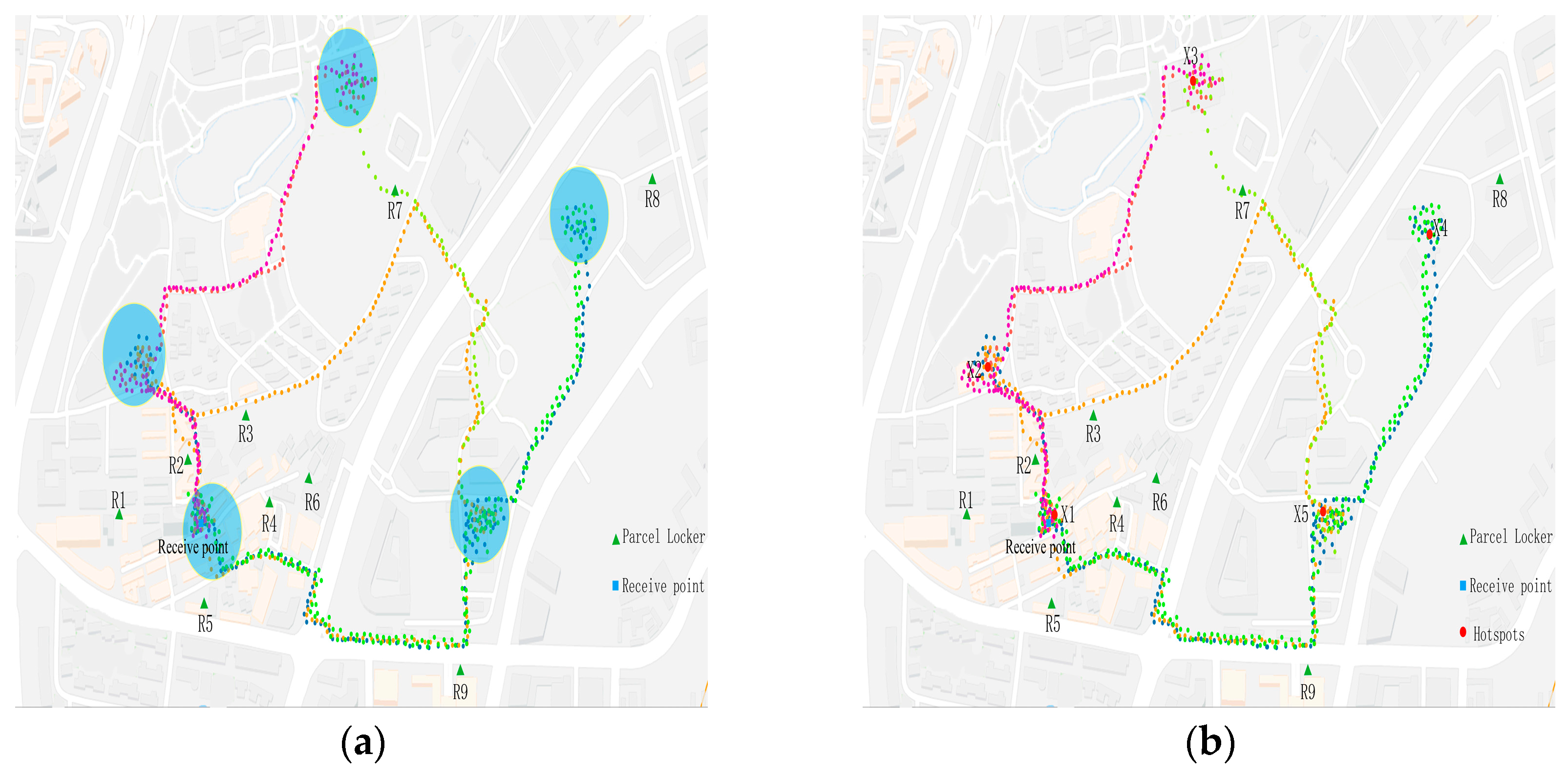
This paper selected three classic PLC location models for simulation comparison to ensure the coverage of different optimization objectives and methodologies: The Greedy Coverage algorithm aimed to maximize service coverage by iteratively selecting PLC locations that cover the most unserved demand. The Static KDE method relied on fixed hotspot distributions from historical data without incorporating dynamic user behavior parameters. The spatiotemporal clustering model (ST-DBSCAN) employed a density-based clustering algorithm combining spatial and temporal dimensions for hotspot detection. Synthetic data was generated based on OpenStreetMap to simulate an urban road network containing 50 PLCs and 1000 users. Comparative metrics included the following:
1. Detour distance reduction rate: The deviation ratio between user pickup routes and regular routes (core metric).
2. Route matching degree: The spatial overlap rate between model-recommended paths and actual user trajectories (Jaccard similarity).
3. Time efficiency: Average duration from notification to pickup (minutes).
4. Resource utilization: The PLC load balancing degree (standard deviation) and facility usage rate (%).
All models shared identical PLC location sets, parcel attributes, and bandwidth parameters. The evaluation adopted 5-fold cross-validation, with 80% training data for model development and 20% test data for performance validation. Independent sample t-tests were conducted to verify the statistical significance of detour distance reduction rate differences between the proposed model and baseline models. The bootstrap method (1000 resamples) was used for confidence interval analysis to calculate 95% confidence intervals.

4. Results

The method proposed in this paper considered user preferences, distance, time, weight, volume, and urgency factors in the selection process of PLCs, effectively achieving the goal of parcel pickup, as demonstrated in Table 1. The method’s effectiveness is illustrated by the selection results of User A.

4.1. Efficiency Analysis

By mining the users’ information, 24 activity hotspots of User A were identified. The analysis of the temporal range and spatial location of the identified hotspots revealed that the identified User A had high spatiotemporal clustering (Figure 6). In reality, User A is a student of Shenzhen University. The characteristics of the user activities are obvious. The hotspots can be divided into three main gathering areas, as shown in the image in Figure 6. Most of the trajectory of User A is back and forth between hotspot cluster area 1 and hotspot cluster region 2. In reality, the receiving position filled by User A was located in hotspot cluster area 1. After removing the hotspots in the aggregation area, 113 presequential hotspots were selected. The regular activity hotspot screening model selected hotspot 2 as the regular activity hotspot for the user (see Table 2). By comparing hotspot 2 with other hotspots, it can be clearly observed that within the spatial location of hotspot 2, the number of hotspots is the greatest, and users spent the longest time in the hotspot 2 area, effectively achieving the goal of the highest degree of aggregation within the selected spatiotemporal range in this article.
When the weight–volume–urgency parameter was RTwv = 2, the PLC selection model chose No.7 PLC for User A (see Table 3). In reality, No.7 PLC is located on the side of the road connecting hotspot cluster area 1 and hotspot cluster area 2. User A generally chose this road from hotspot cluster area 1 to hotspot cluster area 2. It can be seen that the method proposed in this paper was convenient for users to pick up the goods. Secondly, the selected No.7 PLC is located between the receive point and the regular activity hotspot, which is not the closest to the receive point. As shown in Figure 6, No.2 PLC is the nearest to the receive point in the alternative PLCs. The reason is that No.2 PLC is located on the path of hotspots cluster 3 and 1, not the regular path of user A. This verifies that the proposed selection method is consistent with the original intention of the PLC selection model.

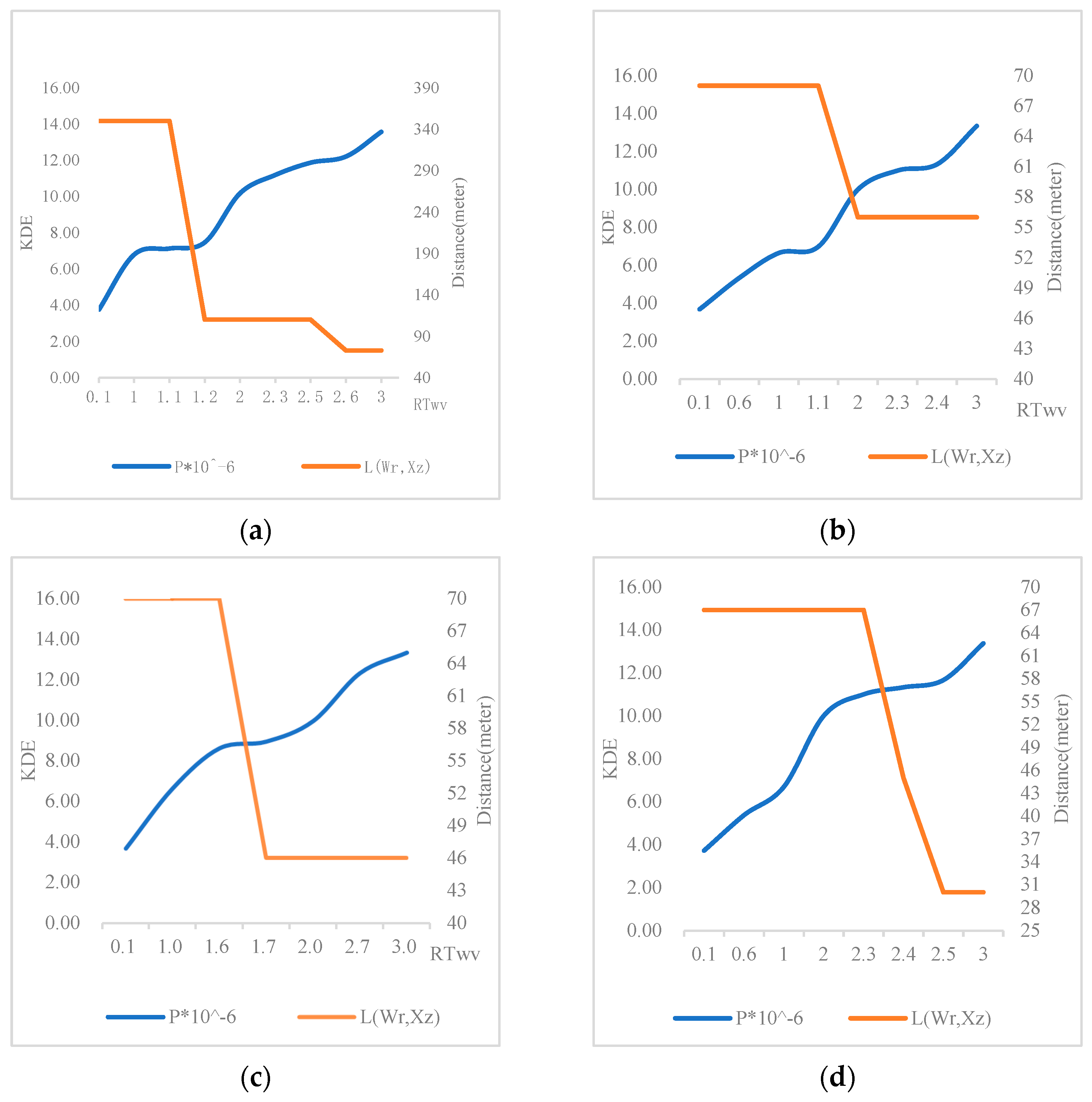
4.2. Weight–Volume–Urgency Parameter Sensitivity Analysis

This article employed a variety of weight–volume–urgency parameters to evaluate operational outcomes. In the objective function of this study (Equation (17)), the weight–volume–urgency parameter ( R T W V ), kernel density value ( p ), and distance to the receive point ( L ) are the core coefficients. To verify the impact of parcel characteristics, we adjusted the parameters within the ranges R T W V 1,3 , with a step size of 0.1, simulating parcel scenarios from low urgency to high urgency.
The results indicate that the optimal solution varied with changes in weight–volume–urgency parameters. Evidently, as urgency increased, the selected PLCs tended to be closer to the receiving point. However, excessively high urgency ( R T W V = 3 ) would compromise the regularity of the path. For instance, after an increase in User A’s weight–volume–urgency parameters, the distance to the delivery point decreased by 68%. The kernel density value p , as the weight–volume–urgency parameters increased, exhibited a linear but gradually increasing trend relative to the weight–volume–urgency parameters, as shown in Figure 7a. When R T W V = 0.1 , P = 3.76 × 10 6 , and after R T W V increased to 3, P = 13.6 × 10 6 . The reason for this is that this article utilized a bandwidth based on the reconstruction kernel function, and the relative bandwidth value was larger, achieving the goal of selecting only the highest aggregate position of the overall data.

4.3. Benchmark Model Simulation Results

The synthesized data verified that under simulated scenarios, the model achieved a 68.2% reduction rate in detour distance, significantly outperforming static KDE (52.1%) and ST-DBSCAN (47.6%). The t-test results showed all comparison p-values < 0.01, demonstrating statistically significant differences. The 95% confidence interval for dynamic KDE was [65.8%, 70.6%], indicating high result stability, as shown in Table 4.

5. Discussion

The present study aimed to address the issue of temporal and spatial mismatches in last-mile logistics distribution by proposing a novel path planning model for the selection of PLCs that considers the convenience of en-route goods pick-up. Our approach integrates user spatiotemporal trajectories with kernel density estimation to identify activity hotspots and optimize the selection of PLCs. The results validate the effectiveness of our model in reducing the “time difference” and “location difference” between users and couriers, representing a constructive contribution to advancing the field of urban logistics and e-commerce delivery.

5.1. Key Findings and Their Implications

Our model identified that users’ activity hotspots exhibit strong spatiotemporal clustering, aligning with previous studies that highlight the regularity and predictability of individual spatiotemporal behavior. By leveraging this pattern, we are able to select PLCs that are more likely to be on users’ regular paths, thereby enhancing user satisfaction and operational efficiency. The selection of PLCs based on kernel density estimation values also considers the weight, volume, and urgency of parcels, providing a practical approach to accommodate the physical limitations of PLCs and the varying sizes of parcels.
In addition, the results of this study demonstrate that integrating user spatiotemporal trajectories with KDE can significantly reduce detour distances for package pickup (e.g., a 68% reduction for User A). This finding aligns with the conclusion of Wang et al. [25], that the regularity of user behavior is crucial for improving logistics efficiency. However, this research further reveals the dynamic impact of packages’ physical characteristics (weight–volume–urgency) on route planning: high-urgency packages tend to require nearer PLCs to be selected, while large-volume packages require balancing distance with facility capacity (see Section 4.1). This differentiated decision-making mechanism addresses the limitation of traditional models that solely use distance as a single metric, providing theoretical support for personalized logistics services.

5.2. Comparison with Existing Studies

Our research is user-centric, focusing on the last-mile delivery process, and extends existing studies in the following ways: (1) It introduces user travel preferences in the selection of PLCs, providing a new perspective for locker location selection compared to previous studies based on cost–benefit analysis, as Deutsch et al. deployed parcel lockers with the objective of profit maximization [7]. (2) Existing research has demonstrated that the deployment of PLCs, combined with user travel patterns, is conducive to improving accessibility. This study further incorporates this finding [18]. During the research process of behavioral preferences, by studying users’ transportation modes and their behavioral hotspots in time and space, the selection of PLCs is optimized by considering users’ travel patterns. (3) Previous studies have paid less attention to package characteristics, while the properties of different items affect user convenience and the degree to which needs are met [7,19,25]. In this study, the selection process of PLCs, the characteristics of parcels (such as weight, volume, and urgency) are creatively combined with the kernel density estimation function to optimize the decision-making for locker selection. Therefore, the methodological framework proposed in this study not only improves the efficiency of PLC usage but also reduces the uneconomical behavior caused by users deviating from their regular paths, enhancing the accessibility of PLCs.

5.3. Limitations and Urban Applicability

Although our research provides an innovative model for self-service locker selection, there are some limitations. (1) Our model treats urban space as two-dimensional and uniform, omitting factors like road networks and building density. This may cause deviations in complex urban areas due to the model’s disregard for the impact of building density on paths. For instance, in high-density urban areas, users may be forced to detour around buildings and choose different route, resulting in discrepancies between theoretical distance and actual travel time [42]. (2) The current model was validated on a limited sample of university students in Shenzhen, activity patterns exhibit strong regularity, which inherently restricts generalizability to broader populations (e.g., older adults’ or professionals’ behavior may be more dispersed), and the number of participants was relatively small, so the model’s generalization capability requires further verification. (3) KDE bandwidth was fixed according to Silverman’s rule. The heterogeneity of user activity ranges in different urban environments was not considered, which may affect the accuracy of the estimation due to the different ranges of human activities or different-scale cities (e.g., small- and medium-sized cities vs. megacities).
The applicability of this model varies by city type: (1) Highly planned scenarios: In areas with regular layouts such as campuses or industrial parks, user activity hotspots are concentrated and path regularity is strong, allowing the model to effectively reduce detours (see results in Section 4.1). (2) High-complexity scenarios: In historic old urban districts or megacity cores, where road networks are intricate and building density is high, extending 3D spatial modeling (e.g., integrating 3D-GIS data) is necessary to improve accuracy. (3) Multimodal transportation scenarios: In cities reliant on public transit (e.g., Tokyo, Singapore), user paths may form multicentric hotspots around subway stations, requiring the model to integrate transfer time costs to redefine spatiotemporal distance [5]. Future work could develop adaptive modules for these scenarios, such as dynamically adjusting KDE parameters via reinforcement learning or incorporating road network topology data to optimize path weights.

5.4. Future Research Directions

To enhance the universality of the model, future research can explore the following aspects: (1) Refine spatial modeling: Due to the two-dimensional space assumption underestimating paths by neglecting vertical movements (e.g., overpasses/underground passages), the homogeneous space assumption overestimates accessibility in complex road networks. Future studies should investigate the impact of heterogeneous spaces and different cargo characteristics on locker selection and how to optimize the model by incorporating urban road network data. At the same time, the model’s errors can also be corrected, such as by introducing a “road network correction coefficient” (dynamically weighted distance based on road network topological data) during the model output stage to partially offset theoretical errors. Simultaneously, GPS data can also be used to concentrate speed parameters, facilitating the identification of transportation nodes through speed conversion, thereby integrating package pickup with travel arrangements. (2) Multidimensional data fusion: Research should introduce larger-scale pedestrian spatiotemporal data or traffic data (Gaode API), or fuse multi-source positioning data, to increase data volume, improve model robustness, and quantify the impact of road obstacles and other factors on the results by incorporating a multimodal traffic time cost function. (3) Dynamic parameter optimization: Adaptive bandwidth selection methods, such as reinforcement learning [43], should be explored, as well as the logistics demand forecasting model combining variational autoencoders with recurrent neural networks [44], to enhance the robustness and adaptability of the model. (4) Emerging technologies such as big data analysis and artificial intelligence should be utilized to further enhance the intelligence and automation level of PLC selection. (5) Cross-scenario validation: The model should be tested in typical city types (e.g., tourist cities, industrial cities) to analyze its performance boundaries and parameter tuning strategies.

6. Conclusions

This study reveals the core value of user spatiotemporal trajectory data in path planning. By employing kernel density estimation (KDE) to unify the modeling of user activity hotspots, parcel physical characteristics (weight–volume–urgency), and path regularity, it demonstrates that behavior-driven PLC site selection can effectively identify activity hotspots, bridges the temporal and spatial gaps between users and couriers, prioritizing PLCs aligned with users’ routine mobility patterns, and reduce detour distances (e.g., a 68% reduction for User A). This research challenges traditional static site selection models for neglecting user preferences and provides theoretical support for the “human-centric” design of logistics. Validation in a campus scenario demonstrates the model’s potential applicability in complex urban environments. For instance, the dynamic matching mechanism between high-density hotspots and PLC networks can be extended to transportation hubs or commercial districts, enabling integrated “commute-pickup” services and offering new insights for multimodal logistics coordination in smart cities.
However, limitations persist. First, the assumption of a homogeneous 2D space overlooks real-world complexities such as road networks and building density, potentially overestimating route efficiency in dense urban areas. Second, the small sample size and localized data (Shenzhen University) limit generalizability. Third, fixed KDE bandwidths may not adapt well to varying activity ranges, risking suboptimal hotspot identification in heterogeneous environments.
Future research should focus on the following: (1) Enhanced Environmental Complexity: Studies should integrate 3D Geographic Information Systems (3D-GIS) with real-time traffic data to simulate multi-level indoor and outdoor route planning, thereby improving model accuracy in complex urban scenarios. (2) Expanded Data Diversity: Subsequent work will incorporate multi-source data (e.g., Amap API commuting traffic, UAV delivery trajectories) and broaden user samples to cover diverse age and occupational groups (e.g., commuters, elderly populations) to validate the model’s generalizability. Additionally, exploring parameter adaptability in specialized scenarios such as emergency medical supply deliveries will be prioritized. (3) Technological Integration and Optimization: Plans include introducing reinforcement learning (RL) to dynamically adjust KDE bandwidth, replacing the current fixed Silverman rule, to better adapt to varying user activity patterns. Furthermore, integrating IoT devices for real-time package monitoring (e.g., temperature-sensitive pharmaceuticals) will enable the development of an intelligent decision-making system linking “demand–path–facility” interactions. (4) Deepened Sustainability: Further quantification of the model’s impact on carbon emissions will be pursued—for instance, estimating fuel savings through reduced detour distances or analyzing the contribution of PLC shared usage to urban resource efficiency. These findings will provide a basis for governments to formulate carbon credit policies.
In summary, this study proposes a path planning framework that integrates user spatiotemporal behavior analysis with kernel density estimation, reinforcing the existing literature on the collaborative optimization of user preferences and logistics efficiency. Compared to cost-oriented models, this framework incorporates user behavior preference metrics into the decision-making process, achieving a paradigm shift from “resource optimization” to “user–resource win–win”. While challenges remain in scalability and environmental realism, the proposed model offers a foundational framework for smart city logistics. It has promising application potential in areas such as e-commerce distribution, multimodal transport integration, and carbon-neutral urban planning.

Author Contributions

Conceptualization, H.Z., L.Z. and P.L.; methodology, H.Z., L.Z. and P.L.; software, H.Z.; validation, H.Z. and L.Z.; formal analysis, H.Z. and P.L.; investigation, H.Z.; resources, L.Z. and P.L.; data curation, H.Z.; writing—original draft preparation, H.Z.; writing—review and editing, H.Z. and P.L.; visualization, H.Z.; supervision, L.Z. and P.L.; project administration, P.L.; funding acquisition, P.L. All authors have read and agreed to the published version of the manuscript.

Funding

This research is supported and funded by the National Natural Science Foundation of China (NO. 52072130) and Guangdong Provincial Scientific and Technological Program (NO. 2023A1111120018).

Institutional Review Board Statement

Not applicable.

Informed Consent Statement

Not applicable.

Data Availability Statement

The original contributions presented in this study are included in the article; further inquiries can be directed to the corresponding author.

Acknowledgments

The School of Civil Engineering and Transportation at Shenzhen University is acknowledged for their technical assistance and the use of facilities that contributed to the successful completion of this research.

Conflicts of Interest

The authors declare no conflicts of interest.

References

  1. Leung, A.; Lachapelle, U.; Burke, M. Spatio-Temporal Analysis of Australia Post Parcel Locker Use during the Initial System Growth Phase in Queensland (2013–2017). J. Transp. Geogr. 2023, 110, 103634. [Google Scholar] [CrossRef]
  2. Wang, D.; Xie, C.D.; Wang, C.; Yin, Z.X. Research on the regularity and predictability of individual spatiotemporal behavior: Taking the activities of Shanghai residents on weekdays as an example. Prog. Geogr. 2021, 40, 433–440. [Google Scholar] [CrossRef]
  3. Ranjbari, A.; Diehl, C.; Dalla Chiara, G.; Goodchild, A. Do Parcel Lockers Reduce Delivery Times? Evidence from the Field. Transp. Res. Part E Logist. Transp. Rev. 2023, 172, 103070. [Google Scholar] [CrossRef]
  4. Anand, N.; Mahmud, S.; van Duin, R. Parcel Lockers Feasibility Analysis Considering Multi-Stakeholder Perspectives. In Proceedings of the 6th International Conference Green Cities 2024: Green Logistics for Greener Cities, Szczecin, Poland, 22–24 May 2024; pp. 1–10. [Google Scholar]
  5. Russo, A.; Basbas, S.; Bouhouras, E.; Tesoriere, G.; Campisi, T. The Study of the 5-Min Walking Accessibility for Pickup Points in Thessaloniki: Enhancing Logistics’ Last Mile Sustainability. In Computational Science and Its Applications—ICCSA 2024 Workshops; Gervasi, O., Murgante, B., Garau, C., Taniar, D., C. Rocha, A.M.A., Faginas Lago, M.N., Eds.; Lecture Notes in Computer Science; Springer Nature Switzerland: Cham, Switzerland, 2024; Volume 14821, pp. 41–53. ISBN 978-3-031-65307-0. [Google Scholar]
  6. Ding, M.; Ullah, N.; Grigoryan, S.; Hu, Y.; Song, Y. Variations in the Spatial Distribution of Smart Parcel Lockers in the Central Metropolitan Region of Tianjin, China: A Comparative Analysis before and after COVID-19. ISPRS Int. J. Geo-Inf. 2023, 12, 203. [Google Scholar] [CrossRef]
  7. Deutsch, Y.; Golany, B. A Parcel Locker Network as a Solution to the Logistics Last Mile Problem. Int. J. Prod. Res. 2018, 56, 251–261. [Google Scholar] [CrossRef]
  8. Olsson, J.; Hellström, D.; Pålsson, H. Framework of Last Mile Logistics Research: A Systematic Review of the Literature. Sustainability 2019, 11, 7131. [Google Scholar] [CrossRef]
  9. Mohammad, W.A.; Nazih Diab, Y.; Elomri, A.; Triki, C. Innovative Solutions in Last Mile Delivery: Concepts, Practices, Challenges, and Future Directions. Supply Chain Forum Int. J. 2023, 24, 151–169. [Google Scholar] [CrossRef]
  10. Wang, Y.; Zhang, D.; Liu, Q.; Shen, F.; Lee, L.H. Towards Enhancing the Last-Mile Delivery: An Effective Crowd-Tasking Model with Scalable Solutions. Transp. Res. Part E Logist. Transp. Rev. 2016, 93, 279–293. [Google Scholar] [CrossRef]
  11. Garg, V.; Niranjan, S.; Prybutok, V.; Pohlen, T.; Gligor, D. Drones in Last-Mile Delivery: A Systematic Review on Efficiency, Accessibility, and Sustainability. Transp. Res. Part D Transp. Environ. 2023, 123, 103831. [Google Scholar] [CrossRef]
  12. Bouhouras, E.; Ftergioti, S.; Russo, A.; Basbas, S.; Campisi, T.; Symeon, P. Unlocking the Potential of Pick-Up Points in Last-Mile Delivery in Relation to Gen Z: Case Studies from Greece and Italy. Appl. Sci. 2024, 14, 10629. [Google Scholar] [CrossRef]
  13. Dong, B.; Hovi, I.B.; Pinchasik, D.R. Analysis of Service Efficiency of Parcel Locker in Last-Mile Delivery: A Case Study in Norway. Transp. Res. Procedia 2023, 69, 918–925. [Google Scholar] [CrossRef]
  14. Seghezzi, A.; Siragusa, C.; Mangiaracina, R. Parcel Lockers vs. Home Delivery: A Model to Compare Last-Mile Delivery Cost in Urban and Rural Areas. Int. J. Phys. Distrib. Logist. Manag. 2022, 52, 213–237. [Google Scholar] [CrossRef]
  15. Schwerdfeger, S.; Boysen, N. Who Moves the Locker? A Benchmark Study of Alternative Mobile Parcel Locker Concepts. Transp. Res. Part C Emerg. Technol. 2022, 142, 103780. [Google Scholar] [CrossRef]
  16. Kahr, M. Determining Locations and Layouts for Parcel Lockers to Support Supply Chain Viability at the Last Mile. Omega 2022, 113, 102721. [Google Scholar] [CrossRef]
  17. Cui, Q.; Zhang, Y.; Yang, G.; Huang, Y.; Chen, Y. Analysing Gender Differences in the Perceived Safety from Street View Imagery. Int. J. Appl. Earth Obs. Geoinf. 2023, 124, 103537. [Google Scholar] [CrossRef]
  18. Lagorio, A.; Pinto, R. The Parcel Locker Location Issues: An Overview of Factors Affecting Their Location. In Proceedings of the 8th International Conference on Information Systems, Logistics and Supply Chain: Interconnected Supply Chains in an Era of Innovation, ILS, Austin, TX, USA, 22–24 April 2020. [Google Scholar]
  19. Peppel, M.; Spinler, S. The Impact of Optimal Parcel Locker Locations on Costs and the Environment. Int. J. Phys. Distrib. Logist. Manag. 2022, 52, 324–350. [Google Scholar] [CrossRef]
  20. Chen, Y.; Zhang, J.; Chen, Y.; Luo, J. Research on the Selection of Self-Pickup Points Based on Customers’ Bounded Rationality. Ind. Eng. Manag. 2015, 20, 92–100. [Google Scholar] [CrossRef]
  21. Qiu, H.; Li, H.; Song, H. Location-Routing Problem for Urban Parcel Lockers Considering Demand-Dependent Last-Mile Delivery and Time Windows. Comput. Integr. Manuf. Syst. 2018, 24, 2612–2621. [Google Scholar] [CrossRef]
  22. Wu, H.; Shao, D.; Ng, W.S. Locating Self-Collection Points for Last-Mile Logistics Using Public Transport Data. In Advances in Knowledge Discovery and Data Mining; Cao, T., Lim, E.-P., Zhou, Z.-H., Ho, T.-B., Cheung, D., Motoda, H., Eds.; Lecture Notes in Computer Science; Springer International Publishing: Cham, Switzerland, 2015; Volume 9077, pp. 498–510. ISBN 978-3-319-18037-3. [Google Scholar]
  23. Fang, J.; Giuliano, G.; Wu, A.-M. The Spatial Dynamics of Amazon Lockers in Los Angeles County; METRANS Transportation Center: Los Angeles, CA, USA, 2019. [Google Scholar]
  24. Patowary, M.M.I.; Peulers, D.; Richter, T.; Melovic, A.; Nilsson, D.; Söilen, K.S. Improving Last-Mile Delivery for e-Commerce: The Case of Sweden. Int. J. Logist. Res. Appl. 2023, 26, 872–893. [Google Scholar] [CrossRef]
  25. Wang, X.; Wong, Y.D.; Shi, W.; Yuen, K.F. An Investigation on Consumers’ Preferences for Parcel Deliveries: Applying Consumer Logistics in Omni-Channel Shopping. Int. J. Logist. Manag. 2023, 35, 557–576. [Google Scholar] [CrossRef]
  26. Pan, X.; Wu, L.; Long, F.; Ma, A. Exploiting User Behavior Learning for Personalized Trajectory Recommendations. Front. Comput. Sci. 2021, 16, 163610. [Google Scholar] [CrossRef]
  27. Chen, J.; Chen, P. Tourism Route Recommendation Algorithm Utilizing Interest Hotspot Maps. Comput. Eng. Des. 2018, 39, 2941–2946. [Google Scholar] [CrossRef]
  28. Xu, C.; Meng, F.; Yuan, G.; Li, Y.; Liu, X. Point-of-Interest Recommendation Algorithm Incorporating Location Influence. J. Comput. Appl. 2019, 39, 3178–3183. [Google Scholar]
  29. Wenhao, Y.U.; Tinghua, A.I.; Min, Y.; Jiping, L.I.U. Detecting “Hot Spots” of Facility POIs Based on Kernel Density Estimation and Spatial Autocorrelation Technique. Geomat. Inf. Sci. Wuhan Univ. 2016, 41, 221–227. [Google Scholar] [CrossRef]
  30. Węglarczyk, S. Kernel Density Estimation and Its Application. ITM Web Conf. 2018, 23, 00037. [Google Scholar] [CrossRef]
  31. Cao, W.; Li, Z.; Wei, Q.; Chu, Y. Trajectory Classification Approach Based on Probability Density Estimation of Regional Distribution. Comput. Eng. 2018, 44, 262–267, 286. [Google Scholar]
  32. King, T.L.; Thornton, L.E.; Bentley, R.J.; Kavanagh, A.M. The Use of Kernel Density Estimation to Examine Associations between Neighborhood Destination Intensity and Walking and Physical Activity. PLoS ONE 2015, 10, e0137402. [Google Scholar] [CrossRef]
  33. Lv, A.; Sun, B.; Sun, Y.; Yang, C. Spatial Point Pattern Analysis of Inbound Logistics Activities Based on GPS Trajectory Data. In Proceedings of the 2022 10th International Conference on Traffic and Logistic Engineering (ICTLE), Macau, China, 12–14 August 2022; pp. 107–111. [Google Scholar]
  34. Güngör, E.; Özmen, A. Distance and Density Based Clustering Algorithm Using Gaussian Kernel. Expert Syst. Appl. 2017, 69, 10–20. [Google Scholar] [CrossRef]
  35. Soh, Y.; Hae, Y.; Mehmood, A.; Hadi Ashraf, R.; Kim, I. Performance Evaluation of Various Functions for Kernel Density Estimation. Open J. Appl. Sci. 2013, 3, 58–64. [Google Scholar] [CrossRef]
  36. Xie, Z.; Yan, J. Kernel Density Estimation of Traffic Accidents in a Network Space. Comput. Environ. Urban Syst. 2008, 32, 396–406. [Google Scholar] [CrossRef]
  37. Giannoulaki, M.; Christoforou, Z. Pedestrian Walking Speed Analysis: A Systematic Review. Sustainability 2024, 16, 4813. [Google Scholar] [CrossRef]
  38. Shi, H.; Huang, H.; Ma, D.; Chen, L.; Zhao, M. Capturing Urban Recreational Hotspots from GPS Data: A New Framework in the Lens of Spatial Heterogeneity. Comput. Environ. Urban Syst. 2023, 103, 101972. [Google Scholar] [CrossRef]
  39. Su, N.; Zhang, Z.; Chen, J.; Li, W.; Long, Y. Assessing Personal Screen Exposure with Ever-Changing Contexts Using Wearable Cameras and Computer Vision. Build. Environ. 2024, 261, 111720. [Google Scholar] [CrossRef]
  40. Li, W.; Long, Y.; Kwan, M.-P.; Liu, N.; Li, Y.; Zhang, Y. Measuring Individuals’ Mobility-Based Exposure to Neighborhood Physical Disorder with Wearable Cameras. Appl. Geogr. 2022, 145, 102728. [Google Scholar] [CrossRef]
  41. Yu, W.; Ai, T.; Liu, P.; He, Y. Network Kernel Density Estimation Method for Analyzing Hotspots in POI Facility Distribution. Acta Geod. Et Cartogr. Sin. 2015, 44, 1378–1383, 1400. [Google Scholar]
  42. Cui, Q.; Tan, L.; Ma, H.; Wei, X.; Yi, S.; Zhao, D.; Lu, H.; Lin, P. Effective or Useless? Assessing the Impact of Park Entrance Addition Policy on Green Space Services from the 15-Min City Perspective. J. Clean. Prod. 2024, 467, 142951. [Google Scholar] [CrossRef]
  43. Jebbor, I.; Benmamoun, Z.; Hachimi, H. Forecasting Supply Chain Disruptions in the Textile Industry Using Machine Learning: A Case Study. Ain Shams Eng. J. 2024, 15, 103116. [Google Scholar] [CrossRef]
  44. Khlie, K.; Benmamoun, Z.; Fethallah, W.; Jebbor, I. Leveraging Variational Autoencoders and Recurrent Neural Networks for Demand Forecasting in Supply Chain Management: A Case Study. J. Infras. Policy. Dev. 2024, 8, 6639. [Google Scholar] [CrossRef]
Figure 1. Pedestrian trajectory extraction. (a) Spatial–temporal trajectory; (b) Walk trajectory. Colored points represent trajectory points, with non-walking trajectories marked within the yellow halos.
Applsci 15 06607 g001
Figure 2. Hhotspot identification. (a) Hotspots identified; (b) Hotspot location calculation. The blue circle indicates the active hotspot area, while the red point represents the calculated hotspot location.
Applsci 15 06607 g002
Figure 3. Activity hotspot screening. (a) Before activity hotspot screening; (b) After activity hotspot screening. The yellow halo indicates irregular path, while the blue halo represents calculated regular activity hotspot.
Applsci 15 06607 g003
Figure 4. Parcel locker selection. (a) Regular hotspot selection; (b) PLC selection. The blue line indicates the distance between the regular activity hotspot and the recipient point, while the black line represents the distance between the parcel locker and the regular activity hotspot as well as the recipient point.
Applsci 15 06607 g004
Figure 5. Trajectory collection terminal.
Applsci 15 06607 g005
Figure 6. User A’s hotspot distribution.
Applsci 15 06607 g006
Figure 7. Effect of weight–volume–urgency parameter on PLC selection. (a) Effects of User A; (b) Effects of User B; (c) Effects of User C; (d) Effects of User D. R T W V parameters increase from 0.1 to 3, with a step size of 0.1.
Applsci 15 06607 g007
Table 1. Test result of 4 real users.
Test ObjectUser AUser BUser CUser D
Number of hotspots24291736
Selected regular hotspot number2524
Selected PLC number (α = 2)7614
Distance reduction rate68%62%65%57%
Table 2. User A’s regular activity hotspot.
Hotspot NumberLongitudeLatitudeArrival TimeLeave Time
2113.933456422.529014410:49:3022:19:03
Table 3. PLC selection result.
α PLC NumberDistance to the Receipt Point (Meter)Distance from the Regular Hotspot (Meter)
27110512
Table 4. Benchmark model performance comparison.
IndicatorModel in This PaperGreedy AlgorithmStatic KDEST-DBSCAN
Bypass distance reduction rate (%)68.238.452.147.6
Path matching degree85.362.774.269.8
Time efficiency (minutes)7.512.39.110.4
Load balancing degree (standard deviation)0.180.420.290.35
PLC utilization rate (%)41.526.734.229.8
p-value-0.00010.00230.0004
Disclaimer/Publisher’s Note: The statements, opinions and data contained in all publications are solely those of the individual author(s) and contributor(s) and not of MDPI and/or the editor(s). MDPI and/or the editor(s) disclaim responsibility for any injury to people or property resulting from any ideas, methods, instructions or products referred to in the content.

