
Volcanic Rejuvenation and Hydrothermal Systems: Implications for Conservation and Resource Assessment in the Southeastern Tyrrhenian Sea

 ,
,  , ,
, , 
Abstract
Featured Application
Abstract
1. Introduction
1.1. Legal Aspects of Deep Sea Mining
1.2. Further Detail on Regulatory Aspects of Reference (The Italian Case)
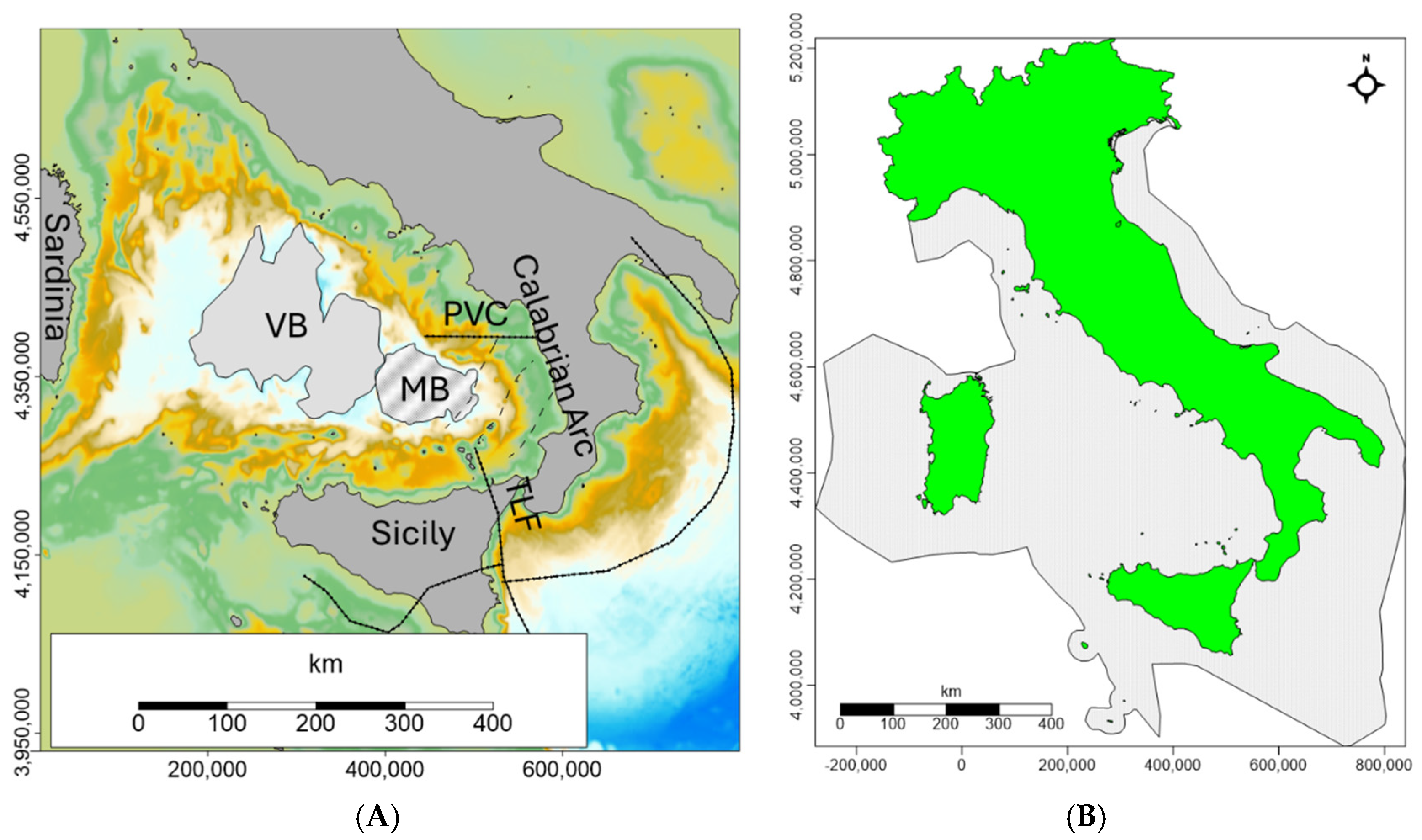
2. Geological Background
The Tyrrhenian Sea
3. Data and Methods
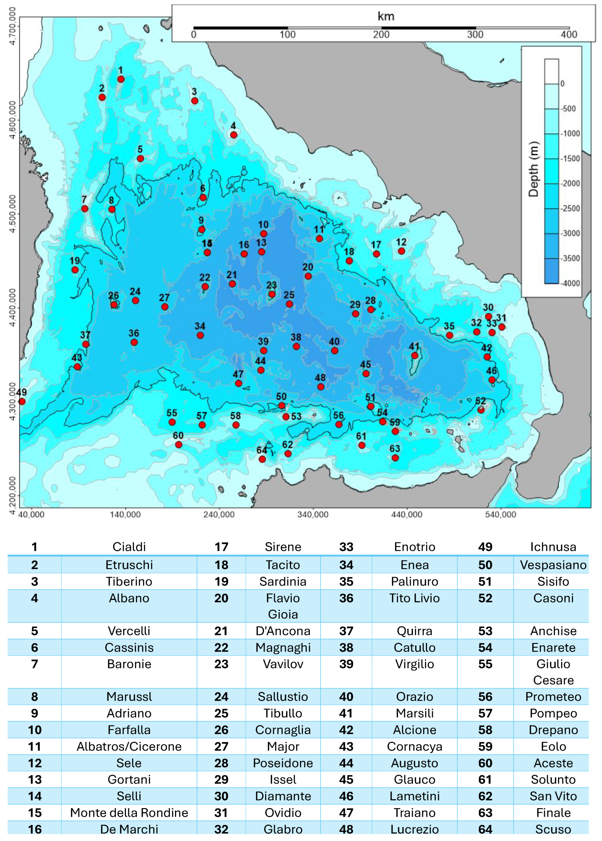
3.1. Bathymetry
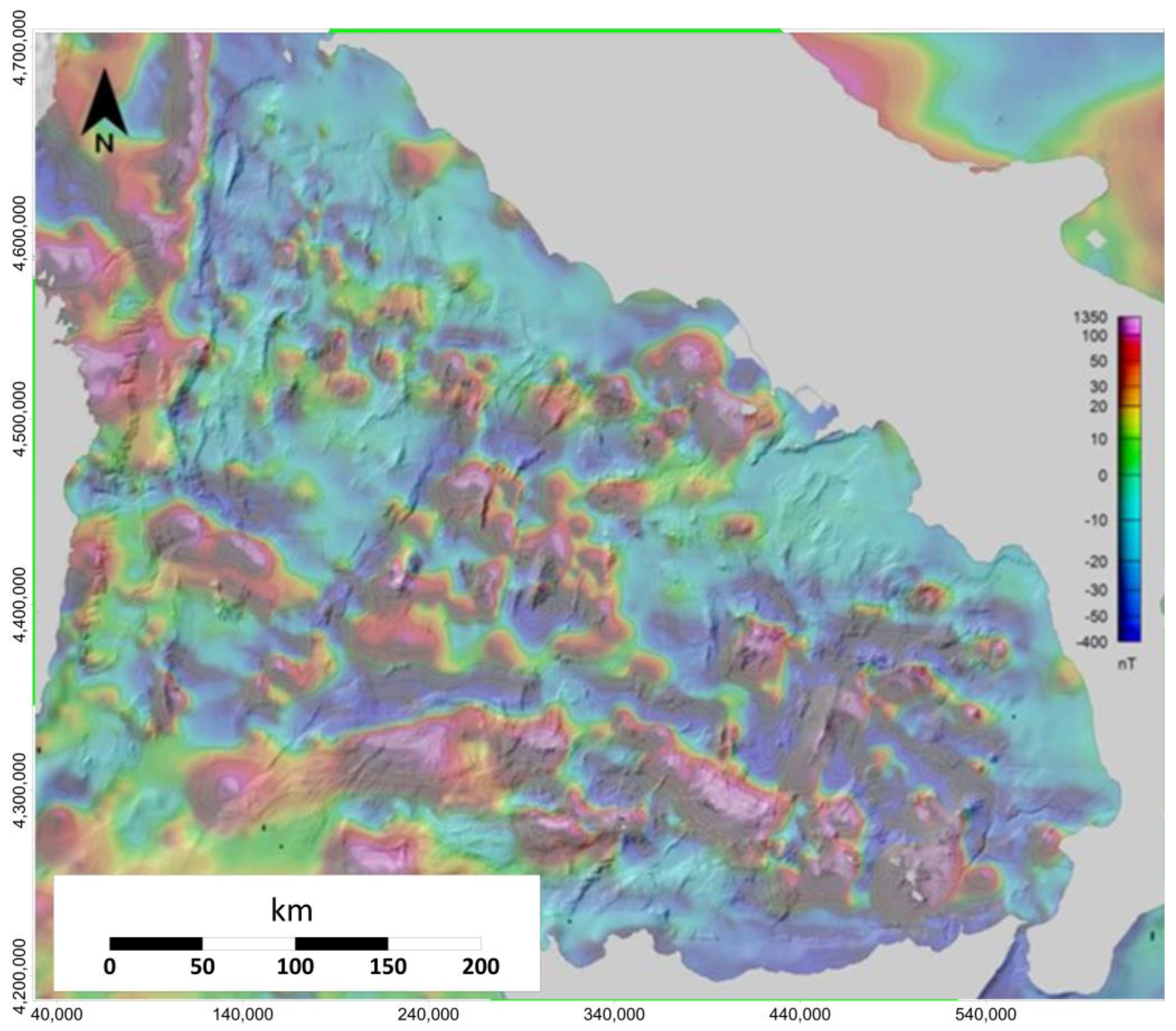
3.2. Magnetics
4. Results and Discussion
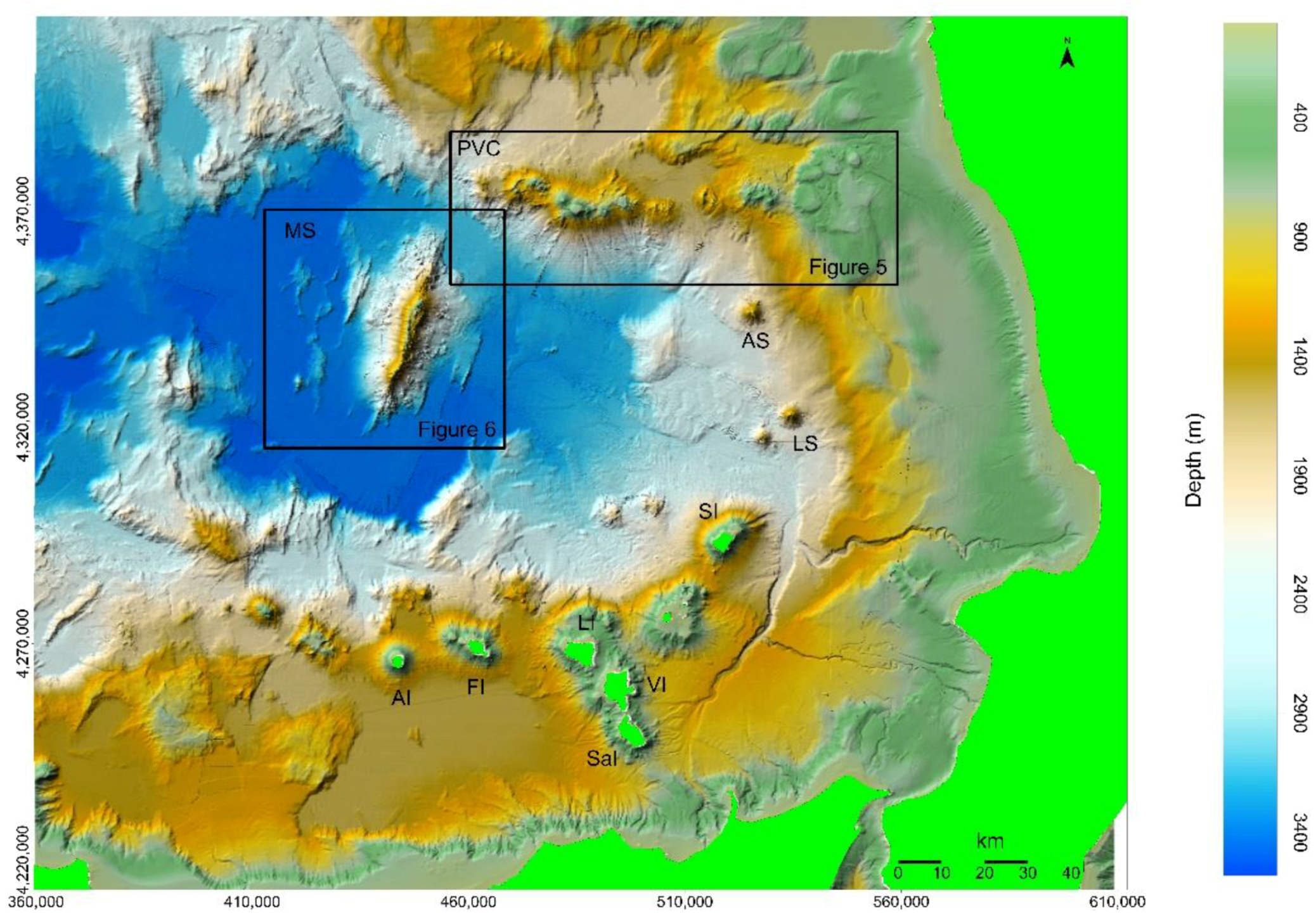
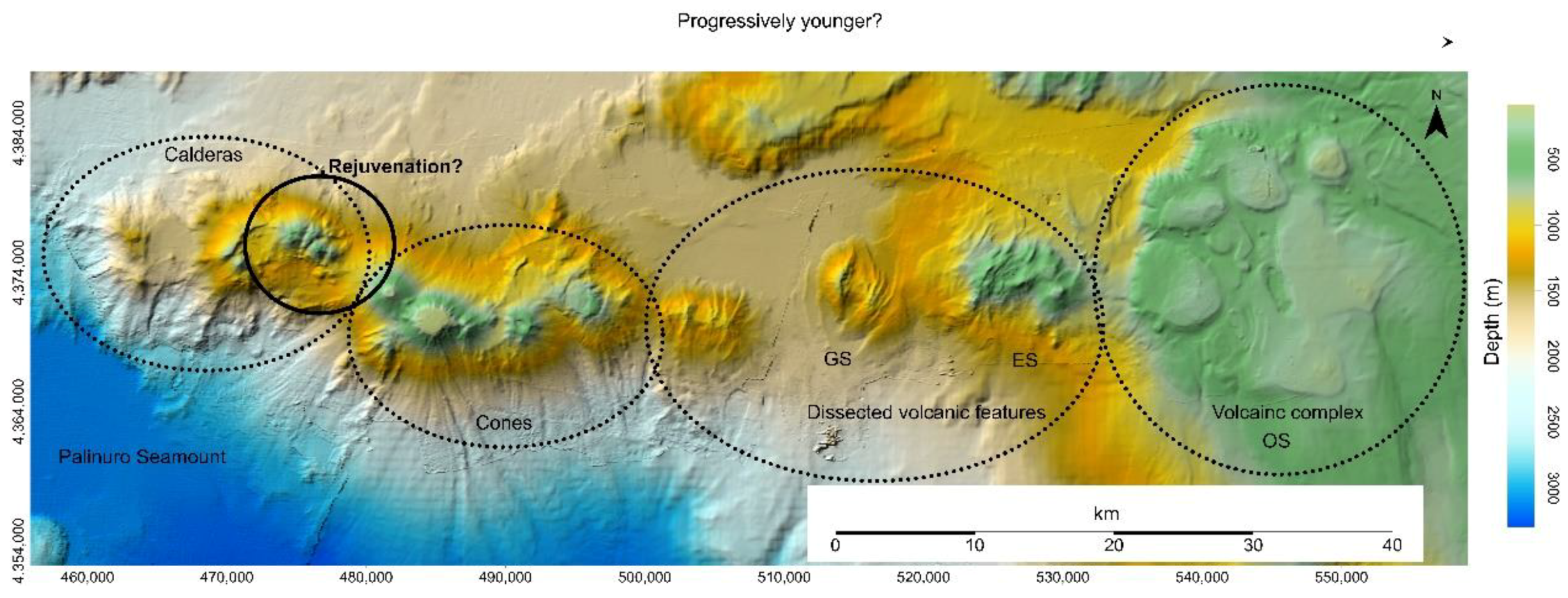
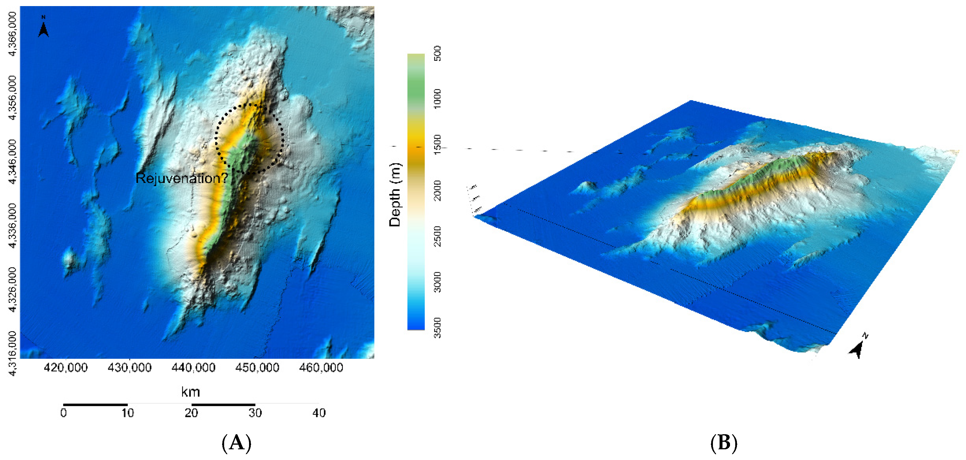
4.1. Back-Arc Spreading Vents and Deposits
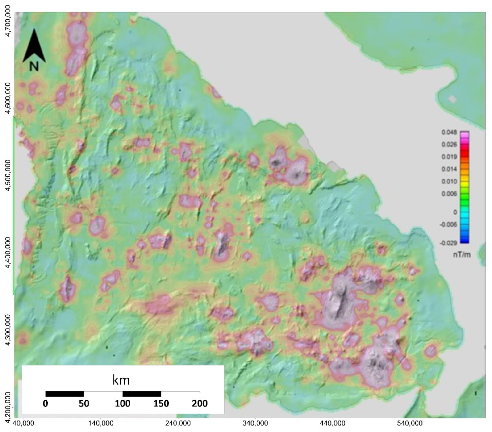
4.2. Magnetic Source Boundaries in the SE Tyrrhenian Sea
4.3. Hydrothermal Vents and Products of the SE Tyrrhenian Sea
5. Conclusions
Author Contributions
Funding
Data Availability Statement
Acknowledgments
Conflicts of Interest
References
- Singh, P.; Jaeckel, A. Undermining by Mining? Deep Seabed Mining in Light of International Marine Environmental Law. AJIL Unbound 2024, 118, 72–77. [Google Scholar] [CrossRef]
- Xu, X.; Li, M.; Xue, G. Revisiting the “Responsibility to Ensure”: Two-Line Standards of the Sponsoring State’s National Legislation on Deep Seabed Mining. Sustainability 2023, 15, 8095. [Google Scholar] [CrossRef]
- Schmidt, O.; Rivera, M. No people, no problem-narrativity, conflict, and justice in debates on deep-seabed mining. Geogr. Helv. 2020, 75, 139–150. [Google Scholar]
- Washburn, T.W.; Simon-Lledó, E.; Soong, G.Y.; Suzuki, A. Seamount mining test provides evidence of ecological impacts beyond deposition. Curr. Biol. 2023, 33, 3065–3071.e3. [Google Scholar]
- van Putten, E.I.; Aswani, S.; Boonstra, W.J.; De la Cruz-Modino, R.; Das, J.; Glaser, M.; Heck, N.; Narayan, S.; Paytan, A.; Selim, S.; et al. History matters: Societal acceptance of deep-sea mining and incipient conflicts in Papua New Guinea. Marit. Stud. 2023, 22, 32. [Google Scholar]
- Orcutt, B.N. I’ve witnessed the wonders of the deep sea. Mining could destroy them. Nature 2023, 619, 673. [Google Scholar] [CrossRef]
- Martins, I.; Guerra, A.; Azevedo, A.; Harasse, O.; Colaço, A.; Xavier, J.; Caetano, M.; Carreiro-Silva, M.; Martins, I.; Neuparth, T.; et al. A modelling framework to assess multiple metals impacts on marine food webs: Relevance for assessing the ecological implications of deep-sea mining based on a systematic review. Mar. Pollut. Bull. 2023, 191, 114902. [Google Scholar]
- Weaver, P.P.E.; Aguzzi, J.; Boschen-Rose, R.E.; Colaço, A.; de Stigter, H.; Gollner, S.; Haeckel, M.; Hauton, C.; Helmons, R.; Jones, D.O.B.; et al. Assessing plume impacts caused by polymetallic nodule mining vehicles. Mar. Policy 2022, 139, 105011. [Google Scholar] [CrossRef]
- Sha, F.; Xi, M.; Wen, Z.; Chen, X.; Zuo, Y.; Xu, J.; Zhang, M.; Niu, H. A review on plumes generation and evolution mechanism during deep-sea polymetallic nodules mining. Ocean Eng. 2024, 298, 117188. [Google Scholar] [CrossRef]
- Hauton, C.; Brown, A.; Thatje, S.; Mestre, N.C.; Bebianno, M.J.; Martins, I.; Bettencourt, R.; Canals, M.; Sanchez-Vidal, A.; Shillito, B.; et al. Identifying toxic impacts of metals potentially released during deep-sea mining—A synthesis of the challenges to quantifying risk. Front. Mar. Sci. 2017, 4, 368. [Google Scholar] [CrossRef]
- Hein, J.; Koschinsky, A.; Bau, M.; Manheim, F.; Kang, J.-K.; Roberts, L. Cobalt-Rich Ferromanganese Crusts in the Pacific. In Handbook of Marine Mineral Deposits; Cronan, D.S., Ed.; CRC Press: Boca Raton, FL, USA, 2000; Chapter 9. [Google Scholar]
- Petersen, S.; Krätschell, A.; Augustin, N.; Jamieson, J.; Hein, J.R.; Hannington, M.D. News from the seabed—Geological characteristics and resource potential of deep-sea mineral resources. Mar. Policy 2016, 70, 175–187. [Google Scholar] [CrossRef]
- Lebre, E.; Kung, A.; Savinova, E.; Valenta, R.K. Mining on land or in the deep sea? Overlooked considerations of a reshuffling in the supply source mix. Resour. Conserv. Recycl. 2023, 191, 106898. [Google Scholar]
- Hannington, M.; Petersen, S.; Krätschell, A. Subsea mining moves closer to shore. Nat. Geosci. 2017, 10, 158–159. [Google Scholar] [CrossRef]
- Cheng, Y.; Dai, Y.; Zhang, Y.; Yang, C.; Liu, C. Status and Prospects of the Development of Deep-Sea Polymetallic Nodule-Collecting Technology. Sustainability 2023, 15, 4572. [Google Scholar] [CrossRef]
- Liu, B.; Wang, X.; Zhang, X.; Liu, J.; Rong, L.; Ma, Y. Research Status of Deep-Sea Polymetallic Nodule Collection Technology. J. Mar. Sci. Eng. 2024, 12, 744. [Google Scholar] [CrossRef]
- Directive 2008/56—Framework for Community Action in the Field of Marine Environmental Policy (Marine Strategy Framework Directive). Available online: https://www.eumonitor.eu/9353000/1/j4nvk6yhcbpeywk_j9vvik7m1c3gyxp/vitgbgiogxml#:~:text=The%20marine%20strategy%20framework%20directive,means%20of%20an%20ecosystem%2Dbased (accessed on 17 October 2024).
- Folkersen, M.V.; Fleming, C.M.; Hasan, S. Depths of uncertainty for deep-sea policy and legislation. Glob. Environ. Change 2019, 54, 1–5. [Google Scholar] [CrossRef]
- Ardito, G.; Rovere, M. Racing the clock: Recent developments and open environmental regulatory issues at the International Seabed Authority on the eve of deep-sea mining. Mar. Policy 2022, 140, 105074. [Google Scholar] [CrossRef]
- Available online: https://www.un.org/depts/los/convention_agreements/texts/unclos/unclos_e.pdf (accessed on 17 October 2024).
- Andreone, G. Legal patchwork and national borders in the Mediterranean Sea. In CNR Case Histories in the Blue Planet Economy; Vitali, G., Zoppi, I.M., Eds.; Quaderni IRCrES 16; CNR-IRCrES: Moncalieri, Italy, 2022; pp. 113–124. [Google Scholar] [CrossRef]
- Law No. 91, June 14, 2021, “Istituzione Di Una Zona Economica Esclusiva Oltre il Limite Esterno del Mare Territoriale”, Entered into Force on 08 July 2021 (GU No. 148 of 23 June 2021). Available online: https://www.gazzettaufficiale.it/eli/id/2021/06/23/21G00103/sg (accessed on 3 October 2024).
- MinAmbiente Third report on Natural Capital. Available online: https://www.milanogreenforum.com/en/minambiente-third-report-on-natural-capital-2019/ (accessed on 22 October 2024).
- United Nations Decade on Ecosystem Restoration (2021–2030): Resolution/Adopted by the General Assembly. Available online: https://digitallibrary.un.org/record/3794317?v=pdf (accessed on 3 October 2024).
- Malinverno, A.; Ryan, W.B.F. Extension in the Tyrrhenian Sea and shortening in the Apennines as a result of arc migration driven by sinking of the lithosphere. Tectonics 1986, 5, 227–245. [Google Scholar] [CrossRef]
- Della Vedova, B.; Pellis, G.; Foucher, J.P.; Rhéault, J.-P. Geothermal structure of the Tyrrhenian Sea. Mar. Geol. 1984, 55, 271–289. [Google Scholar] [CrossRef]
- Suhadolc, P.; Panza, G.F. Physical properties of the lithosphere–asthenosphere system in Europe from geophysical data. Proceedings of ‘The lithosphere in Italy’. Accad. Naz. Lincei 1989, 80, 15–40. [Google Scholar]
- Scarascia, S.; Lozej, A.; Cassinis, R. Crustal structures of the Ligurian, Tyrrhenian and Ionian Seas and adjacent onshore areas interpreted from wide-angle seismic profiles. Boll. Geofis. Teor. Appl. 1994, 36, 5–19. [Google Scholar]
- Kastens, K.; Mascle, J.; Auroux, C.; Bonatti, E.; Broglia, C.; Channell, J.; Curzi, P.; Emeis, K.-C.; Glaçon, G.; Hasegawa, S.; et al. ODP Leg 107 in the Tyrrhenian sea: Insights into passive margin and back-arc basin evolution. Geol. Soc. Am. Bull. 1988, 100, 1140–1156. [Google Scholar] [CrossRef]
- Savelli, C. Time-space distribution of magmatic activity in the western Mediterranean and peripheral orogens during the past 30 Ma (a stimulus to geodynamic considerations). J. Geodyn. 2002, 34, 99–126. [Google Scholar] [CrossRef]
- Lupton, J.; De Ronde, C.; Sprovieri, M.; Baker, E.T.; Bruno, P.P.; Italiano, F.; Walker, S.; Faure, K.; Leybourne, M.; Britten, K.; et al. Active hydrothermal discharge on the submarine Aeolian Arc. J. Geophys. Res. Solid Earth 2011, 116, B02102. [Google Scholar]
- Rosenbaum, G.; Lister, G.S. Neogene and Quaternary rollback evolution of the Tyrrhenian Sea, the Apennines and the Sicilian Maghrebides. Tectonics 2004, 23, TC1013. [Google Scholar] [CrossRef]
- Beccaluva, L.; Gabbianelli, G.; Lucchini, F.; Rossi, P.L.; Savelli, C. Petrology and K/Ar ages of volcanic dredged from the Eolian seamounts: Implications for geodynamic evolution of the Southern Tyhrrenian basin. Earth Planet. Sci. Lett. 1985, 74, 187–208. [Google Scholar] [CrossRef]
- Cultrera, F.; Barreca, G.; Burrato, P.; Ferranti, L.; Monaco, C.; Passaro, S.; Pepe, F.; Scarfì, L. Active faulting and continental slope instability in the gulf of patti (Tyrrhenian side of NE sicily, Italy): A field, marine and seismological joint analysis. Nat. Hazards 2017, 86, S253–S272. [Google Scholar] [CrossRef]
- Cultrera, F.; Barreca, G.; Ferranti, L.; Monaco, C.; Pepe, F.; Passaro, S.; Barberi, G.; Bruno, V.; Burrato, P.; Mattia, M.; et al. Structural architecture and active deformation pattern in the northern sector of the Aeolian-Tindari-Letojanni fault system (SE Tyrrhenian Sea-NE Sicily) from integrated analysis of field, marine geophysical, seismological and geodetic data. Ital. J. Geosci. 2017, 136, 399–417. [Google Scholar] [CrossRef]
- De Ritis, R.; Chiappini, M. High resolution magnetic anomalies, volcanism and tectonics of the active “La Fossa” vulcanic system (Vulcano island) and Lipari island (South Italy). J. Volcanol. Geotherm. Res. 2023, 438, 107823. [Google Scholar] [CrossRef]
- Finetti, I.R. The Calabrian Arc and Subducting Ionian Slab from New CROP Seismic Data. In cROP Project: Deep Seismic Exploration of the Central Mediterranean and Italy; Elsevier Science: Amsterdam, The Netherlands, 2005; pp. 393–412. [Google Scholar]
- Scarfì, L.; Barberi, G.; Barreca, G.; Cannavò, F.; Koulakov, I.; Patanè, D. Slab narrowing in the Central Mediterranean: The Calabro-Ionian subduction zone as imaged by high resolution seismic tomography. Sci. Rep. 2018, 8, 5178. [Google Scholar] [CrossRef]
- Cocchi, L.; Passaro, S.; Tontini, F.C.; Ventura, G. Volcanism in slab tear faults is larger than in island-arcs and back-arcs. Nat. Commun. 2017, 8, 1451. [Google Scholar] [CrossRef] [PubMed]
- Passaro, S.; Milano, G.; D’Isanto, C.; Ruggieri, S.; Tonielli, R.; Bruno, P.P.; Sprovieri, M.; Marsella, E. DTM-based morphometry of the Palinuro seamount (Eastern Tyrrhenian Sea): Geomorphological and volcanological implications. Geomorphology 2010, 115, 129–140. [Google Scholar] [CrossRef]
- Passaro, S.; Milano, G.; Sprovieri, M.; Ruggieri, S.; Marsella, E. Quaternary still-stand landforms and relations with flank instability events of the Palinuro Bank (southeastern Tyrrhenian Sea). Quat. Int. 2012, 232, 228–237. [Google Scholar] [CrossRef]
- Caratori Tontini, F.; Cocchi, L.; Carmisciano, C. Rapid 3-d forward model of potential fields with application to the Palinuro Seamount magnetic anomaly (southern Tyrrhenian Sea, Italy). J. Geophys. Res. Solid Earth 2009, 114, B02103. [Google Scholar] [CrossRef]
- Caratori Tontini, F.; Bortoluzzi, G.; Carmisciano, C.; Cocchi, L.; De Ronde, C.E.J.; Ligi, M.; Muccini, F. Near-bottom magnetic signatures of submarine hydrothermal systems at Marsili and Palinuro volcanoes, southern Tyrrhenian Sea, Italy. Econ. Geol. 2014, 109, 2119–2128. [Google Scholar] [CrossRef]
- Soloviev, S.L.; Kuzin, I.P.; Kovachev, S.A.; Ferri, M.; Guerra, I.; Luongo, G. Microearthquakes in the Tyrrhenian Sea as revealed by joint land and sea-bottom seismographs. Mar. Geol. 1990, 94, 131–146. [Google Scholar] [CrossRef]
- Milano, G.; Passaro, S.; Sprovieri, M. Present-day knowledge on the Palinuro Seamount (south-eastern Tyrrhenian Sea). Boll. Geofis. Teor. Appl. 2012, 53, 403–416. [Google Scholar]
- Marani, M.P.; Trua, T. Thermal constriction and slab tearing at the origin of a superinflated spreading ridge: Marsili volcano (Tyrrhenian Sea). J. Geophys. Res. Solid Earth 2002, 107, EPM 3-1–EPM 3-15. [Google Scholar] [CrossRef]
- Tamburrino, S.; Vallefuoco, M.; Ventura, G.; Insinga, D.D.; Sprovieri, M.; Tiepolo, M.; Passaro, S. The proximal marine records of the Marsili Seamount in the last 7 ka (Southern Tyrrhenian Sea back-arc, Italy) put constraints on the evolution of plumbing systems in declining back-arc spreading ridges. Glob. Planet. Change 2015, 133, 2–16. [Google Scholar] [CrossRef]
- Iezzi, G.; Lanzafame, G.; Mancini, L.; Behrens, H.; Tamburrino, S.; Vallefuoco, M.; Passaro, S.; Signanini, P.; Ventura, G. Deep sea explosive eruptions may be not so different from subaerial eruptions. Sci. Rep. 2020, 10, 6709. [Google Scholar] [CrossRef]
- D’Alessandro, A.; D’Anna, G.; Luzio, D.; Mangano, G. The INGV’s new OBS/H: Analysis of the signals recorded at the marsili submarine volcano. J. Volcanol. Geotherm. Res. 2009, 183, 17–29. [Google Scholar] [CrossRef]
- Ventura, G.; Milano, G.; Passaro, S.; Sprovieri, M. The Marsili ridge (Southern Tyrrhenian Sea, Italy): An island-arc volcanic complex emplaced on a ‘relict’ back-arc basin. Earth Sci. Rev. 2013, 116, 85–94. [Google Scholar] [CrossRef]
- Nicotra, E.; Passaro, S.; Ventura, G. The formation and growth mechanisms of young back-arc spreading ridges from high-resolution bathymetry: The Marsili Seamount (Tyrrhenian Sea, Italy). Geosci. Front. 2024, 15, 101723. [Google Scholar] [CrossRef]
- Emodnet Bathymetry. Available online: https://emodnet.ec.europa.eu/en/bathymetry (accessed on 3 October 2024).
- Chiappini, M.; Meloni, A.; Boschi, E.; Faggioni, O.; Beverini, N.; Carmisciano, C.; Marson, I. On shore-offshore integrated shaded relief magnetic anomaly map at sea level of Italy and surrounding areas. Ann. Geophys. 2000, 43, 983–989. [Google Scholar]
- Molina, F.; de Santis, A. Considerations and proposal for a best utilization of IGRF over areas including a geomagnetic observatory. Phys. Earth Planet. Inter. 1987, 48, 379–385. [Google Scholar] [CrossRef]
- Qin, S. An analytic signal approach to the interpretation of total field magnetic anomalies. Geophys. Prospect. 1994, 42, 665–675. [Google Scholar] [CrossRef]
- Franklin, J.M.; Lydon, J.W.; Sangster, D.F. Volcanic-Associated Massive Sulfide Deposits. In Economic Geology 75th Anniversary Volume; Skinner, B.J., Ed.; Society of Economic Geologists: Littleton, CO, USA, 1981; pp. 485–627. [Google Scholar]
- Scott, S.D. Seafloor polymetallic sulphide deposits: Modern and ancient. Mar. Min. 1985, 5, 191–212. [Google Scholar]
- Both, R.A.; Crook, K.; Taylor, B.; Brogan, S.; Chapell, B.; Frankel, E.; Liu, L.; Sinton, J.; Tiffin, D. Hydrothermal chimneys and associated fauna in the Manus back-arc basin, Papua New Guinea. Am. Geophys. Union Trans. 1986, 67, 489–490. [Google Scholar] [CrossRef]
- Craig, H.; Horibe, Y.; Farley, K.A.; Welhan, J.A.; Kim, K.R.; Hey, R.N. Hydrothermal vents in the Mariana Trough: Results of the first Alvin dives. EOS Trans. Am. Geophys. Un. 1987, 68, 1531. Available online: https://cir.nii.ac.jp/crid/1570009750318360064 (accessed on 3 October 2024).
- Kastner, M.; Craig, H.; Sturz, A. Hydrothermal deposition in the Mariana Trough: Preliminary mineralogical investigations. Am. Geophys. Union Trans. 1987, 68, 1531. Available online: https://cir.nii.ac.jp/crid/1573105974063847808 (accessed on 3 October 2024).
- Auzende, J.M.; Urabe, T.; Deplus, C.; Eissen, J.P.; Grimaud, D.; Huchon, P.; Ishibashi, J.; Joshima, M.; Lagabrielle, Y.; Mevel, C.; et al. Le cadre geologique d’ un site hydrothermal actif. la campagne Starmer du submersible nautile dans le Bassin Nord Fidjien. C. R. Acad. Sci. Paris 1989, 309, 1787–1795. [Google Scholar]
- Fouquet, Y.; Von Stackelberg, U.; Charlou, J.L.; Donval, J.L.; Erzinger, J.; Foucher, J.P.; Herzig, P.M.; Mühe, R.; Soakai, S.; Wiedicke, M.; et al. Hydrothermal activity and metallogenesis in the Lau back-arc basin. Nature 1991, 349, 778–781. [Google Scholar] [CrossRef]
- Halbach, P.; Nakamura, K.; Wahsner, M.; Lange, J.; Sakai, H.; Käselitz, L.; Hansen, R.D.; Yamano, M.; Post, J.; Prause, B.; et al. Probable modern analogue of Kuroko-type massive sulphide deposits in the Okinawa Trough backarc basin. Nature 1989, 338, 496–499. [Google Scholar] [CrossRef]
- Binns, R.A.; Scott, S.D. Actively forming polymetallic sulphide deposits associated with felsic volcanic rocks in the Eastern Manus back-arc basin, Papua New Guinea. Econ. Geol. 1993, 88, 2226–2236. [Google Scholar] [CrossRef]
- Rona, P.A. Hydrothermal mineralisation at oceanic ridges. Can. Mineral. 1988, 26, 431–465. [Google Scholar]
- Rona, P.A.; Scott, S.D. Preface to Special Issue on sea-floor hydrothermal mineralisation: New Perspectives. Econ. Geol. 1993, 88, 1935–1976. [Google Scholar] [CrossRef]
- Mitrousis, A. New underwater volcanic formations west of Santorini Island. In Proceedings of the 9th International Multidisciplinary Scientific Geoconference and EXPO—Modern Management of Mine Producing, Geology and Environmental Protection, SGEM 2009, Albena, Bulgaria, 14–19 June 2009; pp. 257–264. [Google Scholar]
- Nomikou, P.; Parks, M.M.; Papanikolaou, D.; Pyle, D.M.; Mather, T.A.; Carey, S.; Watts, A.B.; Paulatto, M.; Kalnins, M.L.; Livanos, I.; et al. The emergence and growth of a submarine volcano: The Kameni Islands, Santorini (Greece). GeoResJ 2014, 1–2, 8–18. [Google Scholar] [CrossRef]
- Nomikou, P.; Hübscher, C.; Carey, S. The Christiana–Santorini–Kolumbo volcanic field. Elements 2019, 15, 171–176. [Google Scholar] [CrossRef]
- Bakalis, E.; Mertzimekis, T.J.; Nomikou, P.; Zerbetto, F. Breathing modes of Kolumbo submarine volcano (Santorini, Greece). Sci. Rep. 2017, 7, 46515. [Google Scholar] [CrossRef]
- Bravakos, P.; Mandalakis, M.; Nomikou, P.; Anastasiou, T.I.; Kristoffersen, J.B.; Stavroulaki, M.; Polymenakou, P.N. Genomic adaptation of pseudomonas strains to acidity and antibiotics in hydrothermal vents at Kolumbo submarine volcano, Greece. Sci. Rep. 2021, 11, 1336. [Google Scholar] [CrossRef]
- Dekov, V.M.; Savelli, C. Hydrothermal activity in the SE Tyrrhenian Sea: An overview of 30 years of research. Mar. Geol. 2004, 204, 161–185. [Google Scholar] [CrossRef]
- Heinicke, J.; Italiano, F.; Maugeri, R.; Merkel, B.; Pohl, T.; Schipek, M.; Görlitz, P.; Braun, T. Evidence of tectonic control on active arc volcanism: The Panarea-Stromboli tectonic link inferred by submarine hydrothermal vents monitoring (Aeolian Arc, Italy). Geophys. Res. Lett. 2009, 22, L04301. [Google Scholar] [CrossRef]
- Conte, A.M.; Caramanna, G. Preliminary characterisation of a shallow water hydrothermal sulphide deposit recovered by scientific divers (Aeolian islands, southern Tyrrhenian Sea). Underw. Technol. 2010, 29, 109–115. [Google Scholar] [CrossRef]
- Martorelli, E.; Italiano, F.; Ingrassia, M.; Macelloni, L.; Bosman, A.; Conte, A.M.; Beaubien, S.E.; Graziani, S.; Sposato, A.; Chiocci, F.L. Evidence of a shallow water submarine hydrothermal field off Zannone Island from morphological and geochemical characterization: Implications for Tyrrhenian Sea Quaternary volcanism. J. Geophys. Res. Solid Earth 2016, 121, 8396–8414. [Google Scholar] [CrossRef]
- Bagnato, E.; Oliveri, E.; Acquavita, A.; Covelli, S.; Petranich, E.; Barra, M.; Italiano, F.; Parello, F.; Sprovieri, M. Hydrochemical mercury distribution and air-sea exchange over the submarine hydrothermal vents off-shore Panarea Island (Aeolian arc, Tyrrhenian Sea). Mar. Chem. 2017, 194, 63–78. [Google Scholar] [CrossRef]
- Safipour, R.; Hölz, S.; Halbach, J.; Jegen, M.; Petersen, S.; Swidinsky, A. A self-potential investigation of submarine massive sulfides: Palinuro Seamount, Tyrrhenian Sea. Geophysics 2017, 82, A51–A56. [Google Scholar] [CrossRef]
- Inguaggiato, S.; Diliberto, I.S.; Federico, C.; Paonita, A.; Vita, F. Review of the evolution of geochemical monitoring, networks and methodologies applied to the volcanoes of the Aeolian Arc (Italy). Earth-Sci. Rev. 2018, 176, 241–276. [Google Scholar] [CrossRef]
- Italiano, F.; Romano, D.; Caruso, C.; Longo, M.; Corbo, A.; Lazzaro, G. Magmatic Signature in Submarine Hydrothermal Fluids Vented Offshore Ventotene and Zannone Islands (Pontine Archipelago, Central Italy). Geofluids 2019, 2019, 8759609. [Google Scholar] [CrossRef]
- D’Alessandro, M.; Gambi, M.C.; Bazzarro, M.; Caruso, C.; Bella, M.D.; Esposito, V.; Gattuso, A.; Giacobbe, S.; Kralj, M.; Italiano, F.; et al. Characterization of an undocumented CO2 hydrothermal vent system in the Mediterranean Sea: Implications for ocean acidification forecasting. PLoS ONE 2024, 19, e0292593. [Google Scholar] [CrossRef]
- Gugliandolo, C.; Maugeri, T.L. Temporal variations in heterotrophic mesophilic bacteria from a marine shallow hydrothermal vent off the Island of Vulcano (Eolian Islands, Italy). Microb. Ecol. 1998, 36, 13–22. [Google Scholar] [CrossRef]
- Panieri, G. The effect of shallow marine hydrothermal vent activity on benthic foraminifera (Aeolian arc, Tyrrhenian sea). J. Foraminifer. Res. 2006, 36, 3–14. [Google Scholar] [CrossRef]
- Maugeri, T.L.; Bianconi, G.; Canganella, F.; Danovaro, R.; Gugliandolo, C.; Italiano, F.; Lentini, V.; Manini, E.; Nicolaus, B. Shallow hydrothermal vents in the southern Tyrrhenian Sea. Chem. Ecol. 2010, 26 (Suppl. S1), 285–298. [Google Scholar] [CrossRef]
- Rodolfo-Metalpa, R.; Lombardi, C.; Cocito, S.; Hall-Spencer, J.M.; Gambi, M.C. Effects of ocean acidification and high temperatures on the bryozoan Myriapora truncata at natural CO2 vents. Mar. Ecol. 2010, 31, 447–456. [Google Scholar] [CrossRef]
- Karuza, A.; Celussi, M.; Cibic, T.; Del Negro, P.; De Vittor, C. Virioplankton and bacterioplankton in a shallow CO2-dominated hydrothermal vent (Panarea Island, Tyrrhenian Sea). Estuar. Coast. Shelf Sci. 2012, 97, 10–18. [Google Scholar] [CrossRef]
- Bortoluzzi, G.; Romeo, T.; La Cono, V.; La Spada, G.; Smedile, F.; Esposito, V.; Sabatino, G.; Di Bella, M.; Canese, S.; Scotti, G.; et al. Ferrous iron- and ammonium-rich diffuse vents support habitat-specific communities in a shallow hydrothermal field off the Basiluzzo Islet (Aeolian Volcanic Archipelago). Geobiology 2017, 15, 664–677. [Google Scholar] [CrossRef]
- Manno, C.; Rumolo, P.; Barra, M.; d’Albero, S.; Basilone, G.; Genovese, S.; Mazzola, S.; Bonanno, A. Condition of pteropod shells near a volcanic CO2 vent region. Mar. Environ. Res. 2019, 143, 39–48. [Google Scholar] [CrossRef]
- Sañé, E.; Ingrassia, M.; Martorelli, E.; Chiocci, F.L. Amino acids in surface sediments of the Zannone Island shelf (Western Mediterranean Sea): Possible bioindicators of submarine hydrothermal activity. Org. Geochem. 2020, 140, 103960. [Google Scholar] [CrossRef]
- Aiello, G.; Mazzini, I.; Parisi, R.; Ingrassia, M.; Barra, D. Are CO2-rich seafloor pockmarks a suitable environment for ostracod assemblages? The example of the Zannone Giant Pockmark (central-eastern Tyrrhenian). Mar. Ecol. 2022, 43, e12698. [Google Scholar] [CrossRef]
- Di Bella, L.; Conte, A.M.; Conti, A.; Esposito, V.; Gaglioti, M.; Ingrassia, M.; De Vittor, C.; Bigi, S. Potential Resilience to Ocean Acidification of Benthic Foraminifers Living in Posidonia oceanica Meadows: The Case of the Shallow Venting Site of Panarea. Geosciences 2022, 12, 184. [Google Scholar] [CrossRef]
- Arcadi, E.; Buschi, E.; Rastelli, E.; Tangherlini, M.; De Luca, P.; Esposito, V.; Calogero, R.; Andaloro, F.; Romeo, T.; Danovaro, R. Novel Insights on the Bacterial and Archaeal Diversity of the Panarea Shallow-Water Hydrothermal Vent Field. Microorganisms 2023, 11, 2464. [Google Scholar] [CrossRef]
- Barosa, B.; Ferrillo, A.; Selci, M.; Giardina, M.; Bastianoni, A.; Correggia, M.; di Iorio, L.; Bernardi, G.; Cascone, M.; Capuozzo, R.; et al. Mapping the microbial diversity associated with different geochemical regimes in the shallow-water hydrothermal vents of the Aeolian archipelago, Italy. Front. Microbiol. 2023, 14, 1134114. [Google Scholar] [CrossRef] [PubMed]
- Sedwick, P.; Stuben, D. Chemistry of shallow submarine warm springs in an arc-volcanic setting: Vulcano Island, Aeolian Archipelago, Italy. Mar. Chem. 1996, 53, 147–161. [Google Scholar] [CrossRef]
- Capaccioni, B.; Tassi, F.; Vaselli, O. Organic and inorganic geochemistry of low temperature gas discharges at the Baia di Levante beach, Vulcano Island, Italy. J. Volcanol. Geotherm. Res. 2001, 108, 173–185. [Google Scholar] [CrossRef]
- Boatta, F.; D’Aalessandro, W.; Gagliano, A.L.; Liotta, M.; Milazzo, M.; Rodolfo-Metalpa, R.; Parello, F. Geochemical survey of Levante Bay, Vulcano Island (Italy), a natural laboratory for the study of ocean acidification. Mar. Pollut. Bull. 2013, 73, 485–494. [Google Scholar] [CrossRef]
- Vizzini, S.; Di Leonardo, R.; Costa, V.; Tramati, C.D.; Luzzu, F.; Mazzola, A. Trace element bias in theuse of CO2 vents as analogues for low pH environments: Implications for contamination levels in acidified oceans. Estuar. Coast. Shelf Sci. 2013, 134, 19–30. [Google Scholar] [CrossRef]
- Italiano, F.; Nuccio, P.M. Geochemical investigations of submarine volcanic exhalations to the east of Panarea, Aeolian Islands, Italy. J. Volcanol. Geotherm. Res. 1991, 46, 125–141. [Google Scholar] [CrossRef]
- Inguggiato, S.; Italiano, F. Helium and carbon isotopes in submarine gases from the Aeolian arc (Southern Italy). In Proceedings of the 9th International Symposium on Water-Rock Interaction-WRI9, Taupo, New Zealand, 30 March–3 April 1998; Arehart and Hulston Rotterdam. pp. 727–730. [Google Scholar]
- Capaccioni, B.; Tassi, F.; Vaselli, D.; Tedesco, D.; Rossi, P.M.L. The November 2002 degassing event at Panarea Island, Italy: The results of a 5 months geochemical monitoring program. Ann. Geophys. 2005, 48, 755–765. [Google Scholar]
- Caracausi, A.; Ditta, M.; Italiano, F.; Longo, M.; Nuccio, P.M.; Paonita, A. Massive submarine gas outputduring the volcanic unrest off Panarea Island (Aeolian arc, Italy):inferences for explosive conditions. Geochem. J. 2005, 39, 459–467. [Google Scholar] [CrossRef]
- Esposito, A.; Giordano, G.; Anzidei, M. The 2002-2003 submarine gas eruption at Panarea volcano (Aeolian Islands, Italy): Volcanology of the seafloor and implications for the hazard scenario. Mar. Geol. 2006, 227, 119–134. [Google Scholar] [CrossRef]
- Gugliandolo, C.; Italiano, F.; Maugeri, T.L. The submarine hydrothermal system of Panarea (Southern Italy): Biogeochemical processes at the thermal fluids-sea bottom interface. Ann. Geophys. 2006, 49, 783–792. [Google Scholar] [CrossRef]
- Esposito, V.; Andaloro, F.; Canese, S.; Bortoluzzi, G.; Bo, M.; Di Bella, M.; Italiano, F.; Sabatino, G.; Battaglia, P.; Consoli, P.; et al. Exceptional discovery of a shallow-water hydrothermal site in the SW area of Basiluzzo islet (Aeolian archipelago, South Tyrrhenian Sea): An environment to preserve. PLoS ONE 2018, 13, e0190710. [Google Scholar] [CrossRef] [PubMed]
- Bouligand, C.; Glen, J.; Blakely, R. Distribution of buried hydrothermal alteration deduced from high-resolution magnetic surveys in Yellowstone National Park. JGR Solid Earth 2014, 119, 2595–2630. [Google Scholar] [CrossRef]
- Tivey, M.; Rona, P.; Schouten, H. Reduced crustal magnetization beneath the active sulfide mound, TAG hydrothermal field, Mid-Atlantic Ridge at 26° N. EPSL 1993, 115, 101–115. [Google Scholar] [CrossRef]
- Kidd, R.B.; Armannson, H. Manganese and iron micronodules from a volcanic seamount in the Tyrrhenian Sea. J. Geol. Soc. 1979, 136, 71–76. [Google Scholar] [CrossRef]
- Minniti, M.; Bonavia, F.F. Copper-ore grade hydrothermal mineralization discovered in a seamount in the Tyrrhenian Sea (Mediterranean): Is the mineralization related to porphyry-coppers or to base metal lodes? Mar. Geol. 1984, 59, 271–282. [Google Scholar] [CrossRef]
- Minniti, M.; Bonavia, F.F.; Dacquino, C.; Raspa, G. Distribution of Mn, Fe, Ni, Co and Cu in young sediments on the Palinuro Seamount in the southeast Tyrrhenian Sea (Mediterranean). Mar. Min. 1986, 5, 277–305. [Google Scholar]
- Stuben, D. Cruise Report Poseidon 200-4 MIPAMEHR-MAST 1—Investigations on Hydrothermalism in the Tyrrhenian and Aeolian Sea; Berichte-Geologisch-Palaontologisches Institut und Museum, Christian-Albrechts Universitat: Kiel, Germany, 1994; Volume 69. [Google Scholar]
- Eckhardt, J.; Glasby, G.P.; Puchelt, H.; Berner, Z. Hydrothermal manganese crusts from enarete and palinuro seamounts in the tyrrhenian sea. Mar. Georesour. Geotechnol. 1997, 15, 175–208. [Google Scholar] [CrossRef]
- Ligi, M.; Cocchi, L.; Bortoluzzi, G.; D’Oriano, F.; Muccini, F.; Tontini, F.C.; De Ronde, C.E.J.; Carmisciano, C. Mapping of seafloor hydrothermally altered rocks using geophysical methods: Marsili and Palinuro seamounts, southern Tyrrhenian Sea. Econ. Geol. 2014, 109, 2103–2117. [Google Scholar] [CrossRef]
- Petersen, S.; Monecke, T.; Westhues, A.; Hannington, M.D.; Gemmell, J.B.; Sharpe, R.; Peters, M.; Strauss, H.; Lackschewitz, K.; Augustin, N.; et al. Drilling shallow-water massive sulfides at the Palinuro volcanic complex, Aeolian Island arc, Italy. Econ. Geol. 2014, 109, 2129–2157. [Google Scholar] [CrossRef]
- De Ritis, R.; Pepe, F.; Orecchio, B.; Casalbore, D.; Bosman, A.; Chiappini, M.; Chiocci, F.; Corradino, M.; Nicolich, R.; Martorelli, E.; et al. Magmatism alonglateral slab edges: Insights from the Diamante-Enotrio-Ovidiovolcanic-intrusive complex (Southern Tyrrhenian Sea). Tectonics 2019, 38, 2581–2605. [Google Scholar] [CrossRef]
- Uchupi, E.; Ballard, R.D. Evidence of hydrothermal activity on Marsili Seamount, Tyrrhenian Basin. Deep Sea Research Part A. Oceanogr. Res. Pap. 1989, 36, 1443–1448. [Google Scholar]
- Monecke, T.; Petersen, S.; Lackschewitz, K.; Hügler, M.; Hannington, M.D.; Gemmell, J.B. Shallow submarine hydrothermal systems in the Aeolian volcanic arc, Italy. EOS Trans. Am. Geophys. Union 2009, 90, 110–111. [Google Scholar] [CrossRef]
- Szitkar, F.; Petersen, S.; Caratori Tontini, F.; Cocchi, L. High-resolution magnetics reveal the deep structure of a volcanic-arc-related basalt-hosted hydrothermal site (Palinuro, Tyrrhenian sea). Geochem. Geophys. Geosystems 2015, 16, 1950–1961. [Google Scholar] [CrossRef]
- Tomassi, A.; de Franco, R.; Trippetta, F. High-resolution synthetic seismic modelling: Elucidating facies heterogeneity in carbonate ramp systems. Pet. Geosci. 2025, 31, petgeo2024-047. [Google Scholar] [CrossRef]
- Jones, D.O.B.; Arias, M.B.; Van Audenhaege, L.; Blackbird, S.; Boolukos, C.; Bribiesca-Contreras, G.; Copley, J.T.; Dale, A.; Evans, S.; Fleming, B.F.M.; et al. Long-term impact and biological recovery in a deep-sea mining track. Nature 2025, 26808. [Google Scholar] [CrossRef]
Disclaimer/Publisher’s Note: The statements, opinions and data contained in all publications are solely those of the individual author(s) and contributor(s) and not of MDPI and/or the editor(s). MDPI and/or the editor(s) disclaim responsibility for any injury to people or property resulting from any ideas, methods, instructions or products referred to in the content. |
© 2025 by the authors. Licensee MDPI, Basel, Switzerland. This article is an open access article distributed under the terms and conditions of the Creative Commons Attribution (CC BY) license (https://creativecommons.org/licenses/by/4.0/).
Share and Cite
Passaro, S.; Vallefuoco, M.; Tamburrino, S.; De Ritis, R.; Sprovieri, M. Volcanic Rejuvenation and Hydrothermal Systems: Implications for Conservation and Resource Assessment in the Southeastern Tyrrhenian Sea. Appl. Sci. 2025, 15, 6174. https://doi.org/10.3390/app15116174
Passaro S, Vallefuoco M, Tamburrino S, De Ritis R, Sprovieri M. Volcanic Rejuvenation and Hydrothermal Systems: Implications for Conservation and Resource Assessment in the Southeastern Tyrrhenian Sea. Applied Sciences. 2025; 15(11):6174. https://doi.org/10.3390/app15116174
Chicago/Turabian StylePassaro, Salvatore, Mattia Vallefuoco, Stella Tamburrino, Riccardo De Ritis, and Mario Sprovieri. 2025. "Volcanic Rejuvenation and Hydrothermal Systems: Implications for Conservation and Resource Assessment in the Southeastern Tyrrhenian Sea" Applied Sciences 15, no. 11: 6174. https://doi.org/10.3390/app15116174
APA StylePassaro, S., Vallefuoco, M., Tamburrino, S., De Ritis, R., & Sprovieri, M. (2025). Volcanic Rejuvenation and Hydrothermal Systems: Implications for Conservation and Resource Assessment in the Southeastern Tyrrhenian Sea. Applied Sciences, 15(11), 6174. https://doi.org/10.3390/app15116174