Review

A Review on Automated Detection and Identification Algorithms for Highway Pavement Distress

1
JSTI Group, Nanjing 211100, China
2
School of Civil Engineering, Southeast University, Nanjing 211100, China
*
Author to whom correspondence should be addressed.
Appl. Sci. 2025, 15(11), 6112; https://doi.org/10.3390/app15116112
Submission received: 3 April 2025 / Revised: 29 April 2025 / Accepted: 14 May 2025 / Published: 29 May 2025
(This article belongs to the Section Transportation and Future Mobility)

Abstract

The global expansion of road networks and the aging of infrastructure have intensified the need for efficient pavement distress detection technologies to ensure road safety and sustainability. While traditional manual inspections are time consuming and labor-intensive, recent advances in automated systems have improved detection precision. However, challenges persist, including limited accuracy, poor generalization across datasets, and high computational demands for pixel-level segmentation. This review systematically examines the evolution of pavement distress detection, covering three key phases: manual inspection, semi-automated systems, and non-destructive automated methods. We analyze advancements in image acquisition (e.g., 2D to 3D, ground to aerial platforms) and processing techniques (e.g., threshold-based segmentation to deep learning), highlighting critical trade-offs between speed, accuracy, and scalability. Our findings reveal that, while modern systems excel in controlled environments, their real-world performance remains inconsistent due to varying imaging conditions and underrepresented distress types. To address these gaps, we propose four future directions: (1) enhancing environmental adaptability through multi-sensor datasets, (2) optimizing datasets via self-supervised learning, (3) deploying lightweight models on edge devices for real-time analysis, and (4) integrating predictive maintenance frameworks. These strategies aim to shift pavement management from reactive repairs to proactive, data-driven decision making, ultimately supporting smarter infrastructure systems.

1. Introduction

The global road network has expanded significantly, but aging infrastructure is nearing critical maintenance limits. This increases the need for effective pavement preservation methods. Pavement distresses reduce driving comfort and road appearance. More importantly, they weaken structural strength, raising accident risks and harming long-term infrastructure sustainability. For instance, cracks wider than 5 mm often allow water damage during rains, speeding up base layer failure.
Regular and thorough pavement condition assessments are essential for maintaining road safety and infrastructure performance across all highway types. However, traditional manual inspections face major limitations in large-scale applications. For example, inspecting one kilometer of a four-lane highway manually takes 3–4 h, making it inefficient for extensive networks. This inefficiency has made automated detection technology necessary for improving maintenance efficiency. Modern pavement inspection systems now widely use vehicle-mounted LiDAR (Light Detection and Ranging) and UAV (Unmanned Aerial Vehicle) photogrammetry. These systems can capture road surface images with millimeter-level precision. Despite these advances, automated pavement distress detection and classification still face challenges. Current recognition algorithms perform poorly, often achieving under 70% accuracy in distress identification. This level of performance fails to meet practical engineering needs.
This review systematically explores the technological evolution of road surface detection. It focuses on the combined progress of image acquisition systems and intelligent processing algorithms during semi-automated and automated non-destructive phases. By analyzing both technological advances and current limitations, this study provides insights for developing fully automated pavement inspection systems. The discussion covers four key aspects: (1) development stages of road surface detection, (2) progress in image acquisition technologies, (3) comparative evaluation of intelligent recognition algorithms, and (4) major technical challenges and future research directions in road surface detection.

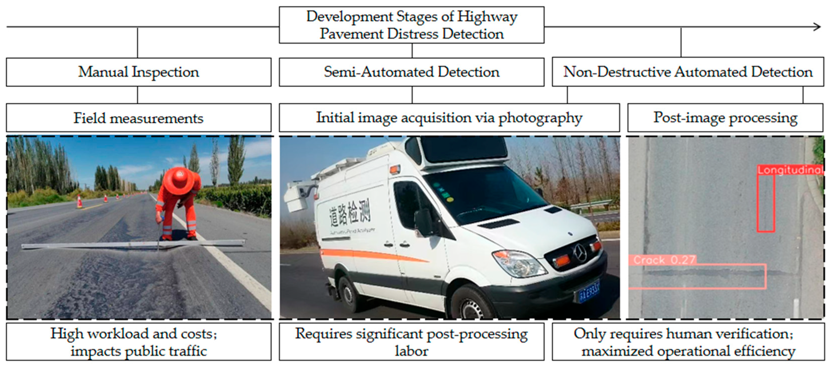
2. Development Stages of Pavement Distress Detection

Pavement distress detection has evolved through three main phases: manual inspection, semi-automated systems, and non-destructive automated methods (Figure 1) [1].

2.1. Manual Inspection Stage

The initial stage depended entirely on manual field surveys using specialized equipment. Although providing direct observations, this method was labor-intensive and time consuming. Additionally, required lane closures often disrupted traffic, creating significant operational difficulties for large highway networks.

2.2. Semi-Automated Detection Stage

Advancements in digital imaging led to semi-automated detection systems. These systems first capture pavement images using standardized cameras and then analyze them with human-assisted distress labeling. This method significantly reduces field investigation time. However, it introduces two major limitations: (1) strict requirements for image quality control and (2) high human resource demands for processing large image datasets (typically captured every 2–4 m). These factors create a bottleneck in the evaluation process, particularly for extensive highway networks covering thousands of kilometers.

2.3. Non-Destructive Automated Detection Stage

The third phase features fully automated, non-destructive detection. This represents a technological breakthrough by combining computer vision and deep learning in post-processing systems. The key advancement lies in integrating high-resolution imaging with intelligent distress classification. This approach reduces human involvement to essential validation tasks, significantly improving efficiency and cost-effectiveness compared to semi-automated methods.
Throughout this process, the iterative advancement of pavement distress detection technology has consistently focused on two core elements: innovations in image acquisition devices and the optimization of image processing algorithms.

3. Evolution of Pavement Image Acquisition Systems

High-quality image acquisition forms the foundation for accurate distress identification and is crucial for automated detection systems. Since road inspection vehicles were first introduced in the 1970s, imaging technology has evolved significantly worldwide. This evolution includes shifts from analog to digital systems, low-speed to high-speed operation, and single to multi-modal sensing capabilities.

3.1. Image Acquisition During Semi-Automatic Detection Stage

During the semi-automatic detection phase, pavement image acquisition technology evolved from analog photography to analog videography and finally to digital imaging.
Developed by France’s LCPC Road Administration, the GERPHO system [2] was among the first operational pavement imaging devices. This pioneering system utilized analog–digital photographic technology to record pavement images on photographic film, enabling a fundamental indoor distress assessment. However, its practical application faced major limitations due to the need for manual film development, time-consuming frame-by-frame analysis, and excessive film storage costs, which ultimately restricted its widespread adoption.
Japan’s Komatsu system [3] marked a technological advance by adopting analog videography. It replaced photographic film with high-performance analog cameras and magnetic tape storage, eliminating the need for film development. However, the system’s maximum operating speed of 10 km/h proved inadequate for large-scale network inspections. Additionally, the required analog-to-digital conversion of video recordings created significant processing bottlenecks.
The 1990s witnessed significant progress in CCD (Charge-Coupled Device) technology, enabling the shift to digital image acquisition. Canada’s Roadware ARAN system [4] leveraged this advancement to achieve 80 km/h data collection speeds, greatly improving inspection efficiency. However, the system faced limitations in low-light conditions due to digital sensors’ short exposure times, requiring artificial lighting that hindered operation in tunnels and at night. These developments laid crucial foundations for modern automated detection methods.

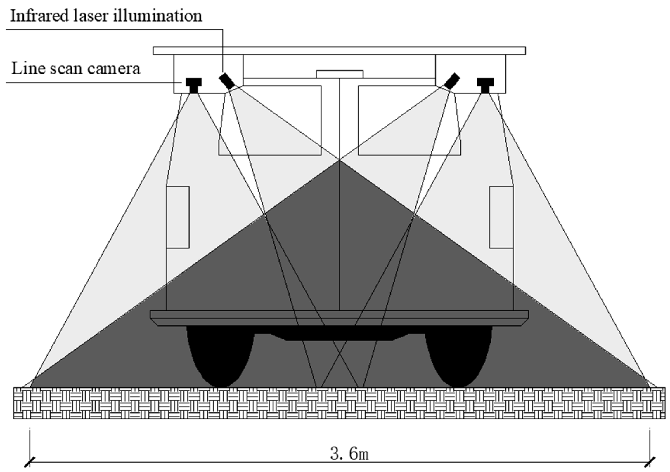
3.2. Image Acquisition During Non-Destructive Automated Detection Stage

Modern non-destructive automated testing systems have reached maturity in the 21st century through key technological integrations. The adoption of high-speed line-scan digital cameras and infrared laser illumination has significantly improved both the accuracy and efficiency of road surface imaging.
Canada’s INO Corporation developed the LRIS system [5] (Figure 2) as an advanced pavement imaging solution. The system combines two high-speed line-scan cameras with dual linear laser sources in a bilateral configuration. This setup provides uniform illumination for each camera, ensuring consistent image quality across varying light conditions. The synchronized dual-camera arrangement captures complete 4 m road sections while overcoming the low-light limitations of traditional systems, particularly during night and tunnel inspections.
Recent advances in 3D imaging [6] and UAV-based systems [7,8,9,10,11,12,13,14,15] have expanded pavement assessment capabilities. Laser profilometer-equipped vehicles [16,17] now produce high-resolution 3D point clouds for precise elevation measurements [18,19], proving particularly effective for identifying three-dimensional distresses, including potholes and rutting. A notable advancement is Zhang’s PaveVision3D system [20], which achieves millimeter-level 3D data accuracy, significantly improving detection reliability for various pavement distresses.
UAV systems provide flexible and cost-effective solutions for infrastructure inspections. In 2022, Seungho Lee et al. [21] developed a deep learning framework for UAV images that automatically addresses vehicle occlusions and shadows to improve detection accuracy. He et al. (2025) further contributed HighRPD [22], a comprehensive UAV dataset containing 11,696 pavement distress samples for advanced image analysis. However, UAV applications still face two major constraints: sensitivity to weather conditions affecting flight stability and a restricted operational range due to limited battery life. These limitations currently position UAV technology as more suitable for detailed local inspections than large-scale network surveys.
Modern non-destructive evaluation systems have significantly advanced image acquisition capabilities, evolving from 2D to 3D imaging and from ground-based to aerial platforms. These multidimensional developments provide a comprehensive data foundation for accurate pavement distress identification and quantification.

4. Evolution of Pavement Image Processing Techniques

Advances in digital image processing algorithms have been equally crucial for automated pavement distress detection. The field has progressed from conventional image processing to machine learning and deep learning approaches, representing a shift from simple segmentation to advanced intelligent recognition systems.

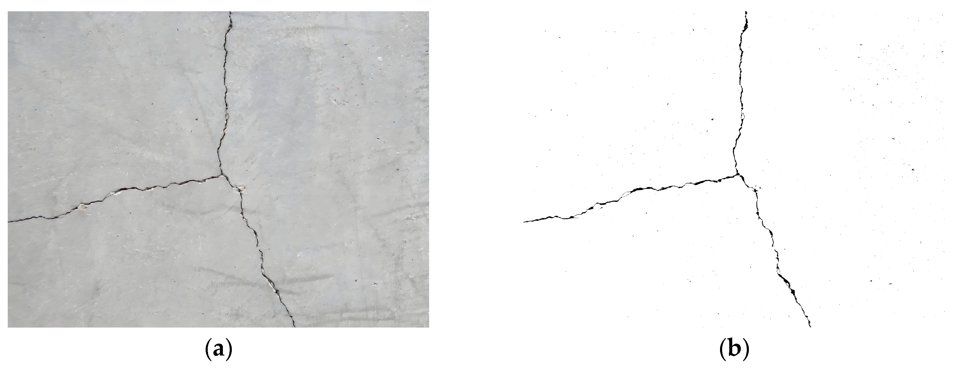
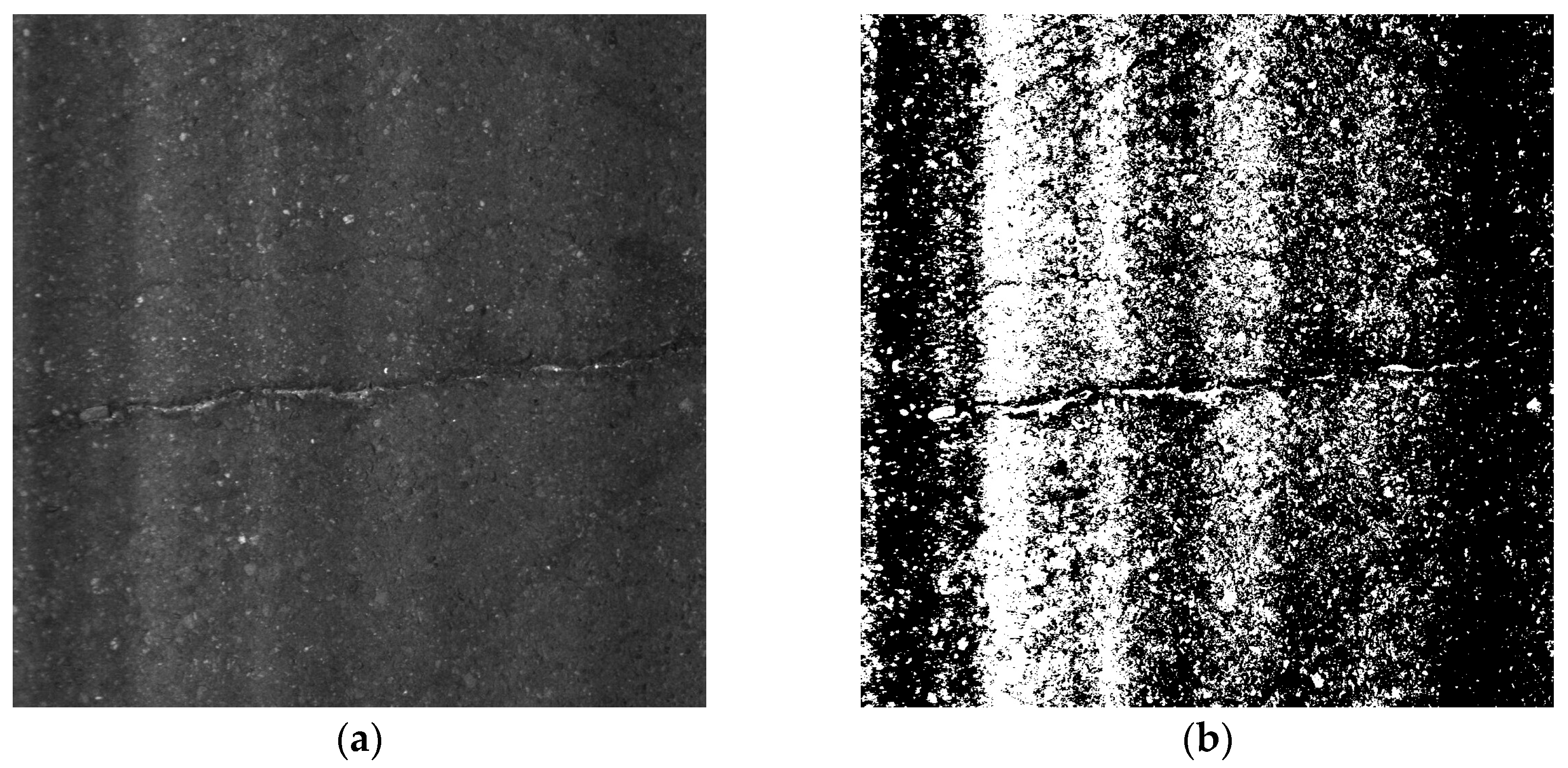
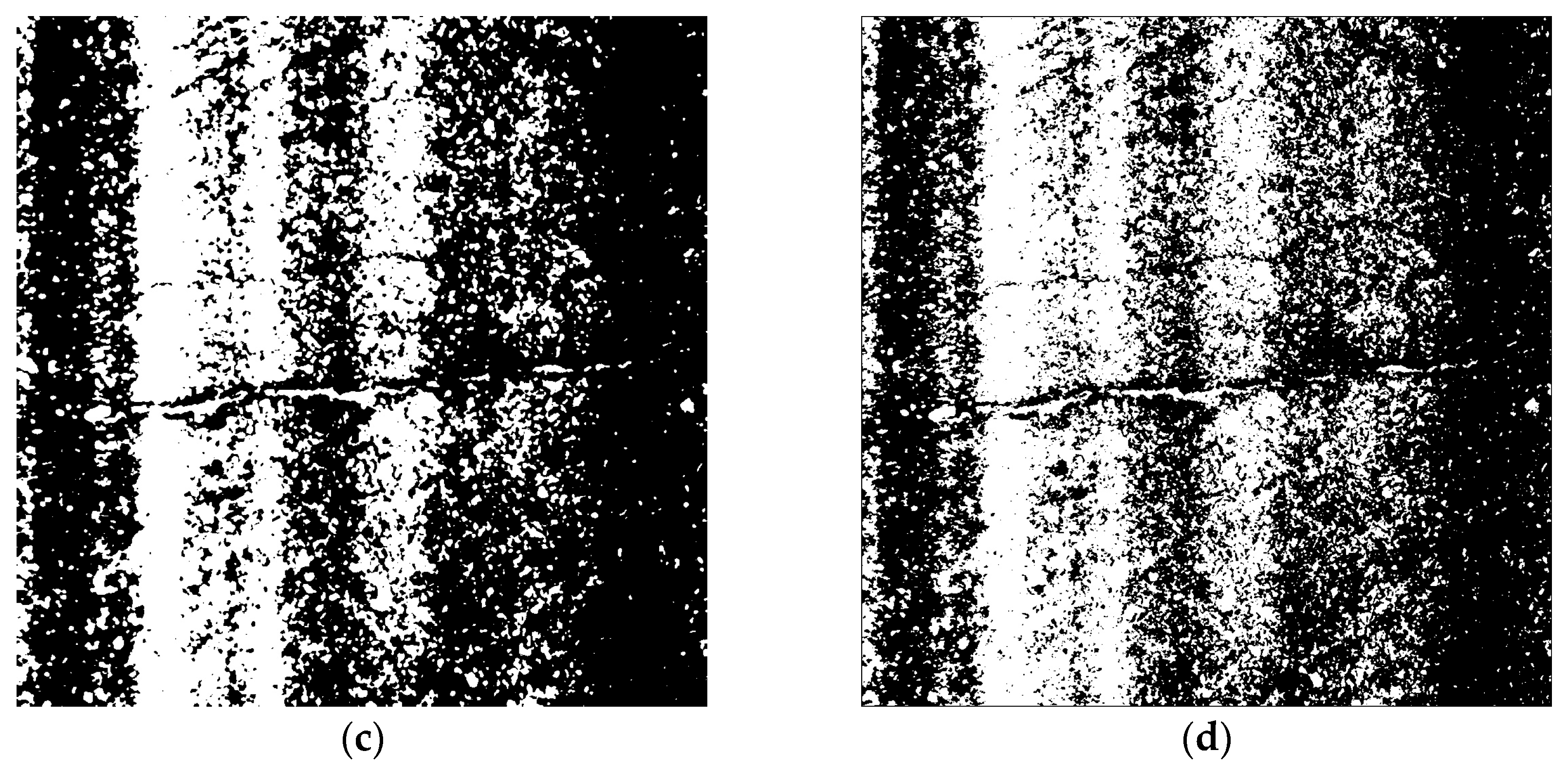
4.1. Conventional Image Processing Techniques

Conventional image processing methods mainly use two core techniques: threshold-based and region-based segmentation. Threshold segmentation converts images to a binary format by analyzing grayscale differences between targets and background, using optimized threshold selection. Region segmentation groups adjacent pixels with similar characteristics based on predefined similarity measures.
Chu Yanli [23] first implemented the Otsu method (OTSU) for asphalt pavement crack segmentation in 2008. This technique selects optimal thresholds by maximizing inter-class variance [24], proving effective for high-contrast PCC (Portland cement concrete) pavement cracks (see reproduced results in Figure 3). However, its performance declines on asphalt surfaces due to (1) complex textural patterns and (2) low grayscale contrast between cracks and background, leading to reduced accuracy (demonstrated in Figure 4b).
Researchers have developed several enhancement methods to improve asphalt crack detection. Key approaches include nonlinear denoising techniques like median filtering [25] and anisotropic diffusion [26], which optimize threshold-based segmentation (see results in Figure 4c,d). However, these improved methods still show limited effectiveness for asphalt crack extraction, suggesting the need for further development.
Liu et al. [27] proposed a region-growing algorithm for automated crack detection, requiring manual seed selection and showing inherent subjectivity. While effective for small targets, this iterative method faces computational challenges with wider, distinct cracks, significantly reducing efficiency [28].
While traditional image processing methods offer viable solutions in constrained scenarios, they exhibit notable limitations when addressing heterogeneous backgrounds, low-contrast targets, and multi-scale distress patterns.

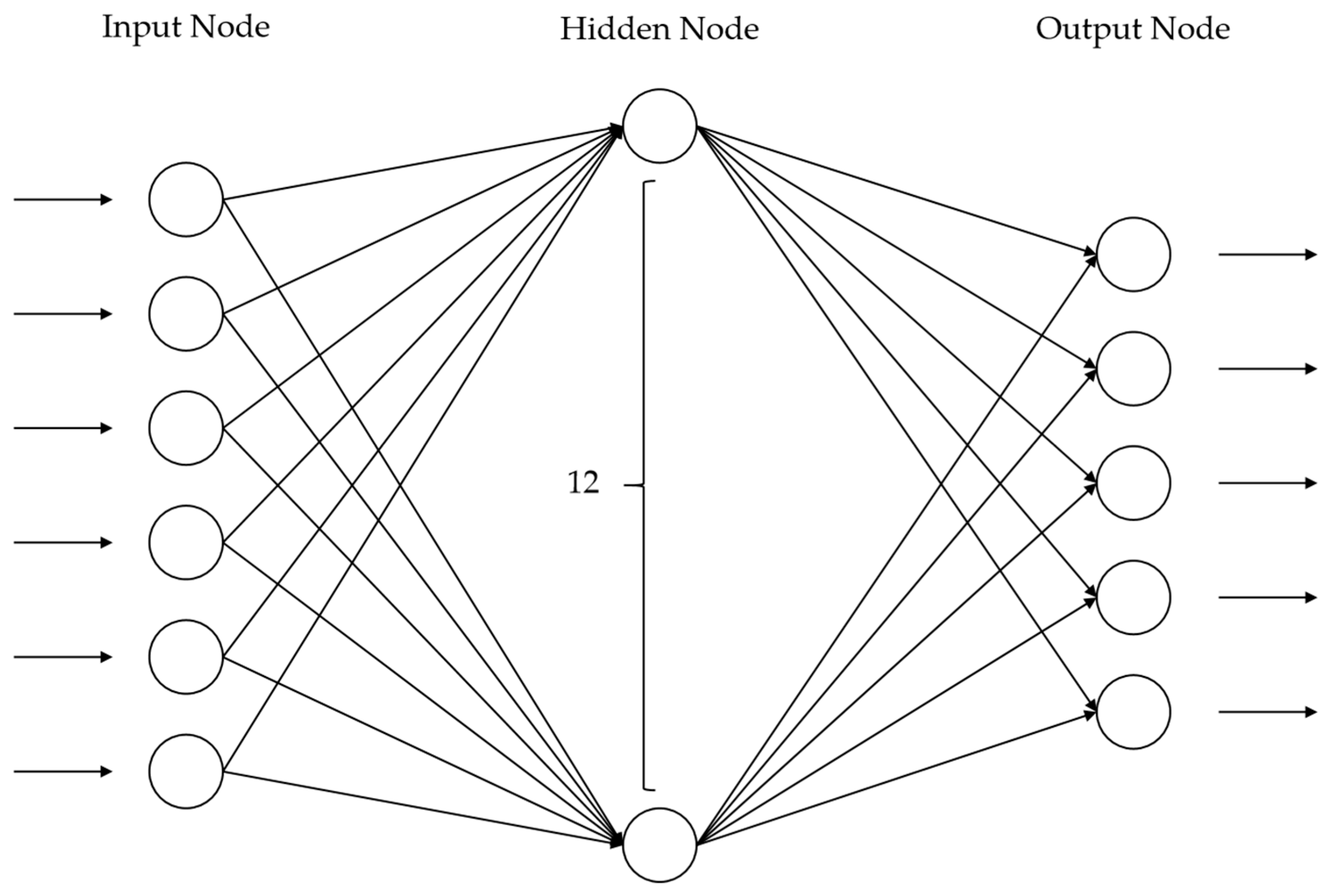
4.2. Conventional Machine Learning Methodologies

Machine learning algorithms have significantly improved pavement distress detection by enabling automated feature extraction from large annotated datasets. These methods enhance both accuracy and automation in infrastructure condition assessment.
Artificial Neural Networks (ANNs), a core machine learning technique, simulate biological neuron connections through interconnected nodes (performing specific functions) and weighted links (defining node relationships). Hu Fan [29] developed a three-layer Back Propagation (BP) neural network (Figure 5) with 6 input nodes, 12 hidden nodes, and 5 output nodes to classify five pavement distress types including transverse and longitudinal cracks. However, this model requires manual preprocessing to extract input parameters (e.g., crack seed count, length) as data lists, limiting its automation capability.
Classical machine learning algorithms, including decision trees, random forests (RFs), and support vector machines (SVMs), have been extensively applied in pavement analysis alongside ANNs. These methods enable preliminary distress classification and localization by extracting key image features like texture patterns and geometric shapes. Table 1 provides a comprehensive comparison of these techniques.
While effective for pavement distress identification, traditional machine learning methods face key limitations in automation and scalability. These algorithms require extensive manual data annotation and struggle with computational efficiency for large datasets. Methods like SVMs and decision trees often overfit training data with poor generalization, despite random forests’ improved performance through ensemble learning. However, even random forests face computational constraints that limit real-time applications. These challenges drive the need for more advanced frameworks to enable accurate, automated infrastructure monitoring.

4.3. Deep Learning Approaches

Deep learning has demonstrated significant potential for large-scale image processing tasks. As a fundamental deep learning architecture, Multilayer Perceptrons (MLPs) extract complex features through nonlinear transformations across multiple hidden layers. Among various models, convolutional neural networks (CNNs) have emerged as a paradigm due to their exceptional image feature extraction capabilities. Unlike traditional machine learning methods requiring manual feature engineering, CNN automatically learn features directly from raw images, making them particularly suitable for large-scale pavement image analysis—including distress classification, localization, and segmentation. Meanwhile, in recent years, transformer-based deep learning frameworks [36,37] have also garnered significant attention and are frequently utilized for network enhancements [38].

4.3.1. Image Classification

Image classification aims to categorize input images into predefined classes. In 2016, Zhang et al. [39] first applied the CNN to pavement distress detection, demonstrating superior crack identification performance compared to SVM and Boosting methods, with enhanced accuracy in distinguishing cracks from background features. Subsequently, Li et al. [40] developed a multi-receptive-field CNN architecture that classifies pavement images into five categories: intact surfaces, transverse cracks, longitudinal cracks, block cracks, and alligator cracks. In 2019, Ye et al. [41] further confirmed CNN’s advantages for pothole recognition. The advancement of deep learning has significantly improved image classification accuracy.

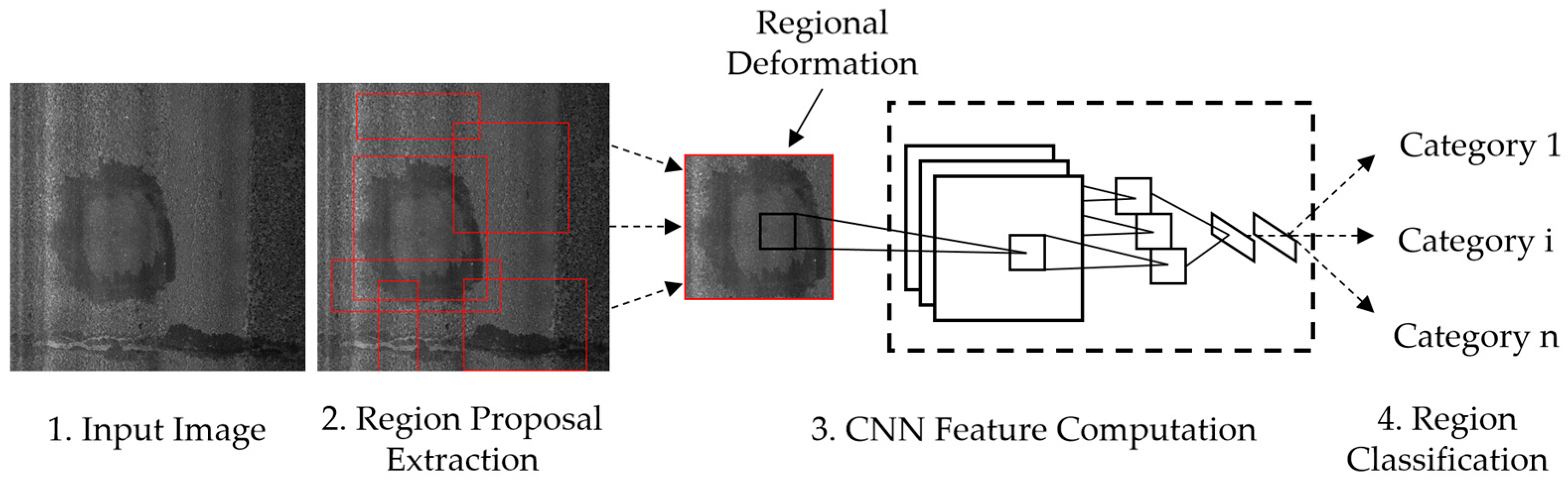
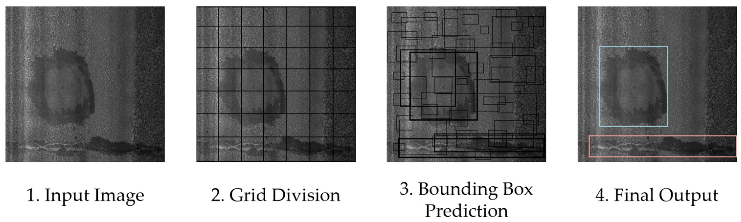
4.3.2. Object Detection

Object detection provides critical advantages for pavement distress analysis by automatically localizing distress areas with bounding boxes, overcoming the limitations of simple CNN classification. This capability enables simultaneous distress identification and severity assessment, significantly advancing automated pavement condition evaluation. Currently, several comprehensive pavement condition analysis methods based on object detection have emerged. For instance, Satheesan et al. [42] combined object detection with Pavement Condition Index (PCI) computation and visualization, while Tan et al. [43] developed 3D object detection networks incorporating BIM (Building Information Modeling) technology for visualized distress management. These research advances collectively provide promising technical support for intelligent engineering applications.
Deep learning-based object detection primarily adopts two-stage or one-stage frameworks. Two-stage object detection algorithms, primarily represented by region-based convolutional neural networks (RCNNs) [44,45,46,47], consist of two sequential steps: region proposal generation followed by classification and regression. This architecture generally achieves higher accuracy compared to one-stage methods. For instance, the RCNN [44] first generates ~2000 candidate regions using selective search (SS) and then processes each region through a CNN for feature extraction and classification (Figure 6).
One-stage detectors such as SSD (Single-Shot MultiBox Detector) [48] and YOLO (You Only Look Once) [49] integrate localization and classification into a single network pass, optimizing for real-time processing. As illustrated in Figure 7, YOLO divides input images into grid cells, each predicting bounding boxes and class probabilities simultaneously, with non-maximum suppression (NMS) removing duplicate detections. This efficient architecture achieves faster inference than two-stage methods, though with slightly lower accuracy in complex cases. In a study by Pradhan et al. [50], the performance of YOLOv5s and Faster RCNN was evaluated using 383 test images. The results showed that YOLOv5s completed object detection on all images in approximately 1.71 min, significantly faster than Faster RCNN, which took around 15 min. However, in terms of detection accuracy, Faster RCNN achieved a higher mean Average Precision (mAP) of 0.795, compared to YOLOv5s’ mAP of 0.683.
Table 2 provides a comparative analysis of contemporary object detection algorithms for road distress recognition, including key performance metrics such as training datasets, target objects, and mAP scores.
Based on the analysis of the aforementioned table, pavement distress detection has evolved from single-defect identification to comprehensive systems capable of detecting multiple complex distress types simultaneously, including transverse cracks, longitudinal cracks, alligator cracking, rutting, and construction joint defects. Modern data collection employs multiple devices (e.g., smartphones, UAVs, vehicle cameras) combined with multi-angle imaging and augmentation techniques to ensure dataset diversity. Algorithm improvements focus on three key aspects: (1) backbone network optimization, (2) advanced feature fusion, and (3) enhanced training strategies using attention mechanisms and activation function refinements.
However, challenges persist in model robustness, as evidenced by performance inconsistencies across datasets. Notably, the mAP scores on public benchmarks like the RDD remain significantly lower than the higher accuracy achieved on HD (high-definition) images from mobile devices and drones, highlighting ongoing limitations in generalization capability and real-world applicability.
Additionally, Li et al. [63] conducted comparative evaluations of common object detection methods on the public RDD2022 dataset, where YOLOv3 and SSD achieved mAP scores of 0.625 and 0.557, respectively, while the improved Faster-RCNN reached 0.698. These results not only confirm the higher accuracy of two-stage detectors but also reveal that current advanced networks still exhibit limited overall recognition accuracy for distress detection.

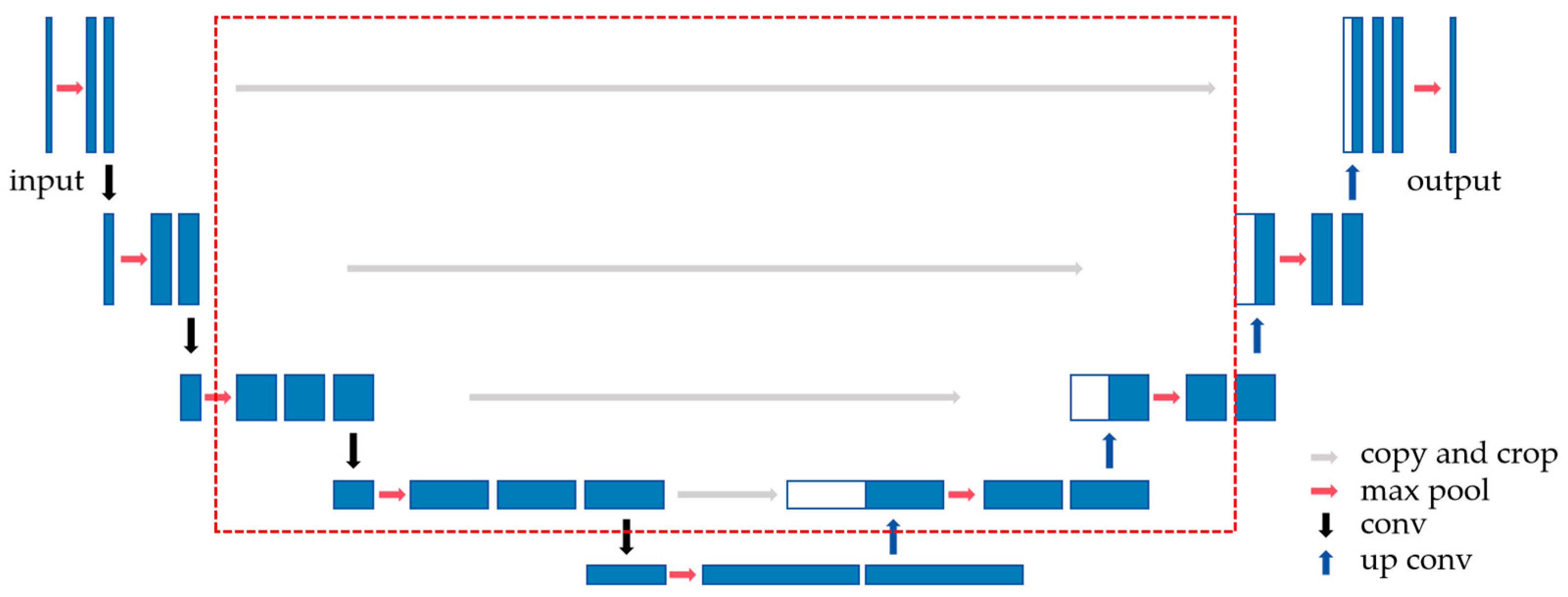
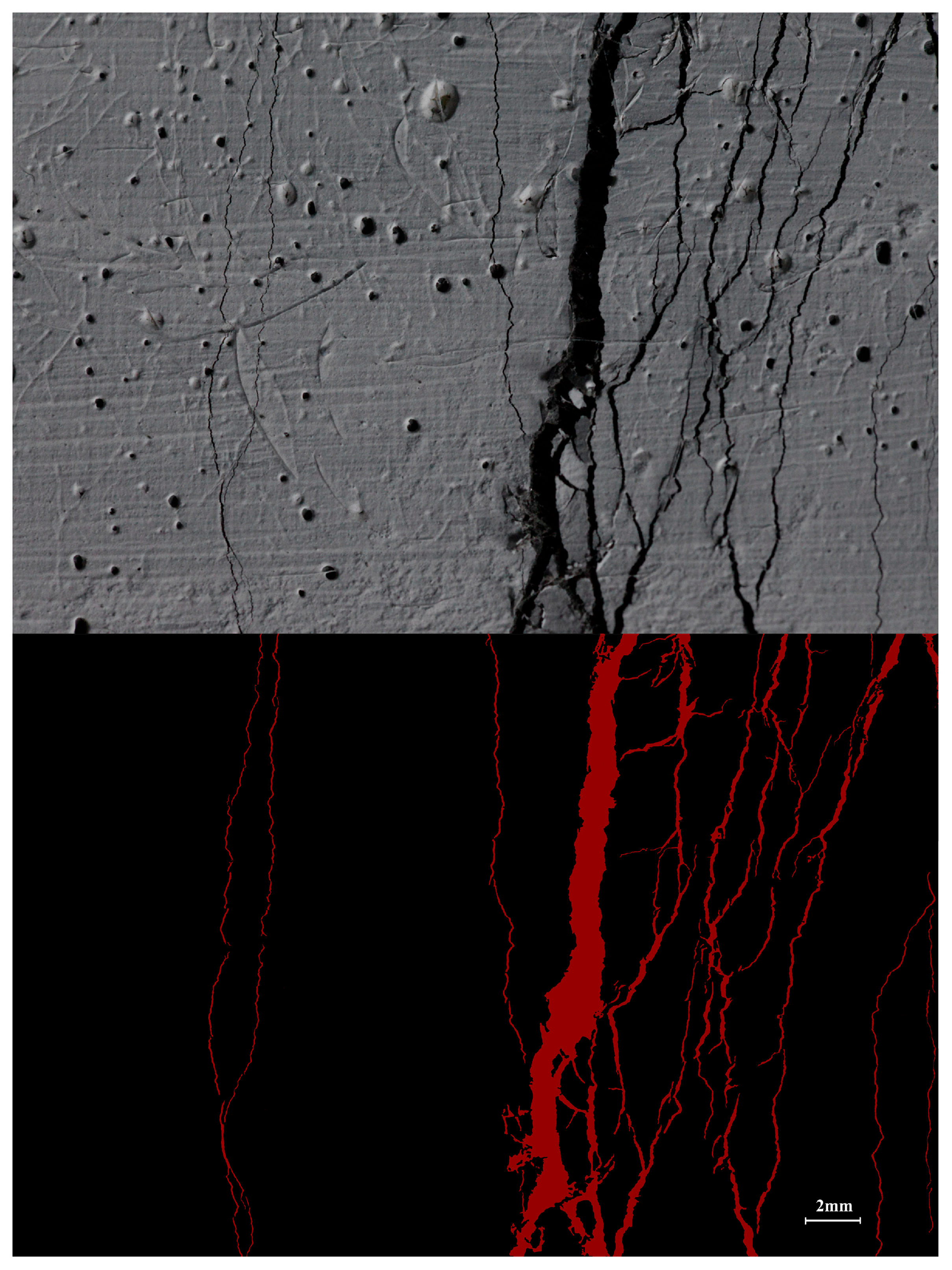
4.3.3. Semantic Segmentation

For quantitative distress assessment, convolutional neural networks perform pixel-level segmentation and area calculation after region selection. Unlike object detection, pixel segmentation precisely delineates distress contours. Current algorithms primarily target challenging-to-identify road cracks, achieving over 90% pixel accuracy (PA). Although the parameter counts vary among different network models, pixel segmentation generally achieves high-precision recognition at the cost of model complexity and training dataset preparation difficulty. For instance, YOLO series models have around 4M parameters, while pixel segmentation models reach approximately 30M [64].
Zou et al. [65,66,67] pioneered the application of U-Net and SegNet in pavement crack detection. The U-Net architecture, originally designed for biomedical image segmentation [68], leverages skip connections to preserve fine-grained spatial details (Figure 8)—a critical advantage for capturing crack morphology. In contrast, SegNet [69] employs pooling indices during upsampling to reduce computational overhead, albeit at the cost of segmentation precision in low-contrast scenarios (e.g., faint asphalt cracks).
Subsequent studies have enhanced pixel segmentation networks through several technical improvements: incorporating lightweight separable convolution blocks [70], integrating attention mechanism modules [71,72,73,74,75,76,77], and reducing network parameters [78,79] to optimize crack segmentation performance and computational efficiency. Zim et al. [80] proposed EfficientCrackNet, a lightweight hybrid architecture integrating a CNN with Transformer modules. The model reduces computational complexity from 15.42 FLOPs (G) to 0.483 FLOPs (G) and decreases parameters from 14.72 M to 0.26 M compared to conventional DeepCrack [81]. Parallelly, Zhang et al. developed a novel deep generative adversarial network named “CrackGAN” [82], which utilizes partially accurate synthetic labeled samples for training, effectively reducing the workload involved in preparing training data for the model.
The pixel-level semantic segmentation of road cracks faces two major challenges: (1) severe class imbalance due to sparse crack pixels, and (2) complex crack morphologies with varying detection difficulties. These factors significantly hinder segmentation performance.
To address these challenges, our previous work developed a CNN-based semantic segmentation model [83,84] specifically designed for crack detection on concrete surfaces. We introduced a dual pre-modification deep learning strategy that simultaneously addresses class imbalance through adaptive weighting and reduces the influence of easily classifiable samples via a difficulty balancing factor. This approach yields the modified binary cross-entropy loss function as expressed in Equation (1):
C E = w 1 ( 1 p ) γ log p ,   y = 1 w 2 p γ log 1 p ,   y = 0 .
The formulation defines y as the ground truth label (where 1 indicates cracks and 0 represents background), p as the predicted probability of “y = 1”, γ as the sample difficulty balancing factor (optimized to 2 through empirical testing), and w as the adaptive weight whose calculation process is detailed in Equation (2):
w i = 1 C a i n = n a i · C .
Here, i indexes the class category (with C = 2 in our binary classification task), n denotes the total pixel count in the dataset, and ai represents the pixel count for class i. The proposed model ultimately achieved 99.79% pixel accuracy (PA) in concrete surface micro-crack detection, with detailed segmentation results of test samples presented in Figure 9.
The proposed model outperforms traditional segmentation and machine learning methods by directly segmenting complex concrete microcracks without denoising preprocessing, enabling high-precision pavement crack analysis. However, asphalt crack segmentation presents greater challenges than concrete cases due to (1) more ambiguous crack boundaries and (2) higher prevalence of complex crack patterns. Therefore, optimal difficulty balancing factors must be determined through comparative parameter experiments.

5. Discussion

5.1. Technical Limitations in Current Paradigms

Pavement distress detection has evolved through three key phases: manual inspection, semi-automated systems, and non-destructive automated solutions. China’s Highway Performance Assessment Standard (JTG 5210-2018) [85] reflects this progression by incorporating automated detection technologies and standardized distress quantification methods. However, current technologies still face several limitations when evaluated against such standards:
First, most object detection models only address common distress types (e.g., linear cracks, potholes), while standards define over a dozen distinct forms for asphalt and concrete pavements. Less frequent but critical distress patterns remain understudied.
Second, deep learning performance varies significantly across imaging conditions. Models optimized for drone/smartphone images show notably reduced accuracy when processing data from professional inspection vehicles—the primary source for official assessments.
Third, training these models requires large annotated datasets. While pavement images are abundant, the labeling process remains resource-intensive.
Finally, even advanced object detection networks achieve only ~70% accuracy. Though pixel-level segmentation offers higher precision, its computational demands hinder large-scale implementation.

5.2. Strategic Roadmap for Next-Generation Systems

To overcome these limitations, this review suggests key research directions for future work:
(1)
Environmental Adaptability: Develop comprehensive multi-condition pavement image datasets incorporating robust sensors (e.g., millimeter-wave radar [86]) while enhancing algorithmic robustness to environmental noise and variations.
(2)
Dataset Optimization: Leverage advanced self-supervised learning techniques [87] to effectively utilize unlabeled pavement images, significantly reducing annotation requirements and improving model generalization.
(3)
Edge Deployment: Following Zhang et al.’s [88] demonstration of YOLOv5s on Jetson TX2 (achieving 90.5% accuracy at 30.7ms), future work should focus on integrating pixel-level segmentation models into specialized inspection vehicles for end-to-end automated road quality assessment.
(4)
Predictive Maintenance: Combine high-precision segmentation models with historical inspection data, traffic load patterns, and environmental factors to develop reliable 3–5 year performance prediction models for proactive maintenance planning.
These advancements will transform pavement management from reactive repairs to proactive maintenance, supporting intelligent transportation infrastructure development.

Funding

This research was funded by Jiangsu Science and Technology Department Projects (grant number 7705008081) and the APC was funded by ongoing research projects of JSTI Group (grant number 8505009479).

Conflicts of Interest

Author Zhenglong Lv was employed by the company JSTI Group. The remaining authors declare that the research was conducted in the absence of any commercial or financial relationships that could be construed as a potential conflict of interest.

References

  1. Ma, J.; Zhao, X.M.; He, S.H.; Song, H.X.; Zhao, Y.; Song, H.S.; Cheng, L.; Wang, J.F.; Yuan, Z.Y.; Huang, F.W.; et al. Review of pavement detection technology. Traffic Transp. Eng. 2017, 17, 121–137. (In Chinese) [Google Scholar]
  2. Lu, J. Application of Image Systemforroad Pavement Distress Test. Master’s Thesis, Southeast University, Nanjing, China, 2007. (In Chinese). [Google Scholar]
  3. Chuai, E.Y. Development summary of international pavement surface distress automatic survey system. Commun. Stand. 2009, 204, 96–99. (In Chinese) [Google Scholar]
  4. Hou, X.S.; Wang, Z.R.; Liu, Z.P. Technical exploration of automatic acquisition and processing equipment for road damage images. Highway 2023, 2, 66–69. (In Chinese) [Google Scholar]
  5. Xu, Z.G. Automatic Recognition Technology for Road Surface Damage Images; Xidian University Press: Xi’an, China, 2018. (In Chinese) [Google Scholar]
  6. Laurent, J.; Talbot, M.; Doucet, M. Road Surface Inspection Using Laser Scanners Adapted for the High Precision 3D Measurements of Large Flat Surfaces. In Proceedings of the International Conference on Recent Advances in 3-D Digital Imaging and Modeling, Ottawa, ON, Canada, 12–15 May 1997. [Google Scholar] [CrossRef]
  7. Themistocleous, K.; Neocleous, K.; Pilakoutas, K.; Hadjimitsis, D.G. Damage Assessment using Advanced Non-Intrusive Inspection Methods: Integration of Space, UAV, GPR, and field spectroscopy. In Proceedings of the Second International Conference On Remote Sensing And Geoinformation of the Environment (RSCy2014), Paphos, Cyprus, 7–10 April 2014. [Google Scholar] [CrossRef]
  8. Pan, Y.; Zhang, X.; Sun, M.; Zhao, Q.Z. Object-based and supervised detection of potholes and cracks from the pavement images acquired by UAV. Int. Arch. Photogramm. Remote Sens. Spat. Inf. Sci. 2017, 42, 209–217. [Google Scholar] [CrossRef]
  9. Pan, Y.; Zhang, X.; Cervone, G.; Yang, L.P. Detection of asphalt pavement potholes and cracks based on the unmanned aerial vehicle multispectral imagery. IEEE J. Sel. Top. Appl. Earth Obs. Remote Sens. 2018, 11, 3701–3712. [Google Scholar] [CrossRef]
  10. Pan, Y.F.; Chen, X.; Sun, Q.; Zhang, X.F. Monitoring asphalt pavement aging and damage conditions from low-altitude UAV imagery based on a CNN approach. Can. J. Remote Sens. 2021, 47, 432–449. [Google Scholar] [CrossRef]
  11. Hong, Z.H.; Yang, F.; Pan, H.Y.; Zhou, R.Y.; Zhang, Y.; Han, Y.L.; Wang, J.; Yang, S.H.; Chen, P.; Tong, X.H.; et al. Highway Crack Segmentation from Unmanned Aerial Vehicle Images Using Deep Learning. IEEE Geosci. Remote Sens. Lett. 2022, 19, 1–5. [Google Scholar] [CrossRef]
  12. Zhu, J.Q.; Zhong, J.T.; Ma, T.; Huang, X.M.; Zhang, W.G.; Zhou, Y. Pavement distress detection using convolutional neural networks with images captured via UAV. Autom. Constr. 2022, 133, 103991. [Google Scholar] [CrossRef]
  13. Zhang, Y.C.; Zuo, Z.W.; Xu, X.B.; Wu, J.Q.; Zhu, J.G.; Zhang, H.B.; Wang, J.W.; Wang, J.W.; Tian, Y. Road damage detection using UAV images based on multi-level attention mechanism. Autom. Constr. 2022, 144, 104613. [Google Scholar] [CrossRef]
  14. Silva, L.A.; Leithardt, V.R.Q.; Batista, V.F.L.; Villarrubia Gonzalez, G.; De Paz Santana, J.F. Automated road damage detection using UAV images and deep learning techniques. IEEE Access 2023, 11, 62918–62931. [Google Scholar] [CrossRef]
  15. Gao, Y.X.; Cao, H.B.; Cai, W.W.; Zhou, G.X. Pixel-level road crack detection in UAV remote sensing images based on ARD-Unet. Measurement 2023, 219, 113252. [Google Scholar] [CrossRef]
  16. Kumar, P.; Angelats, E. An automated road roughness detection from mobile laser scanning data. Int. Arch. Photogramm. Remote Sens. Spat. Inf. Sci. 2017, 42, 91–96. [Google Scholar] [CrossRef]
  17. Ding, S.H.; Zhan, Y.; Yang, E.H.; Wang, C.P. MTD measurement of asphalt pavement based on high precision laser section elevation. J. Southeast Univ. (Nat. Sci. Ed.) 2020, 50, 137–142. [Google Scholar] [CrossRef]
  18. Tan, M. Research on Detection and Reconstruction of Road Surface Based-on Lynx Vehicle-Borne Laser Point Cloud. Master’s Thesis, Central South University, Changsha, China, 2012. (In Chinese). [Google Scholar]
  19. Hedeya, M.A.; Samir, E.; El-Sayed, E.; Abdel-Kader, M.F.; Moussa, A.; Abdel-Kader, R.F. A Low-Cost Multi-sensor Deep Learning System for Pavement Distress Detection and Severity Classification. Lect. Notes Data Eng. Commun. Technol. 2022, 113, 21–33. [Google Scholar] [CrossRef]
  20. Guan, J.C.; Ding, L.; Yang, X.; Liu, P.F.; Wang, H.N. Pavement surface distress detection in complex scenarios driven by multi-dimensional image fusion. J. Traffic Transp. Eng. 2024, 24, 154–179. [Google Scholar] [CrossRef]
  21. Lee, S.; Kim, S.; Moon, S. Development of a car-free street mapping model using an integrated system with unmanned aerial vehicles, aerial mapping cameras, and a deep learning algorithm. J. Comput. Civ. Eng. 2022, 36, 04022003. [Google Scholar] [CrossRef]
  22. He, J.; Gong, L.T.; Xu, C.; Wang, P.; Zhang, Y.Y.; Zheng, O.; Su, G.H.; Yang, Y.F.; Hu, J.L.; Sun, Y.C. HighRPD: A high-altitude drone dataset of road pavement distress. Data Brief 2025, 59, 111377. [Google Scholar] [CrossRef]
  23. Chu, Y.L. Automatic Pavement Crack Identification Systemresearch Based on Digital Image Processing. Master’s Thesis, Chang’an University, Xi’an, China, 2008. (In Chinese). [Google Scholar]
  24. Otsu, N. A threshold selection method from gray-level histograms. IEEE Trans. Syst. Man Cybern. 1979, 9, 62–66. [Google Scholar] [CrossRef]
  25. Li, P.; Wang, C.; Li, S.M.; Feng, B.C. Research on Crack Detection Method of Airport Runway Based on Twice-Threshold Segmentation. In Proceedings of the 2015 Fifth International Conference on Instrumentation and Measurement, Computer, Communication and Control (IMCCC), Qinhuangdao, China, 18–20 September 2015. [Google Scholar] [CrossRef]
  26. Tang, J.S.; Gu, Y.L. Automatic Crack Detection and Segmentation Using a Hybrid Algorithm for Road Distress Analysis. In Proceedings of the 2013 IEEE International Conference on Systems, Man, and Cybernetics, Manchester, UK, 13–16 October 2013. [Google Scholar] [CrossRef]
  27. Liu, F.F.; Xu, G.A.; Yang, Y.X.; Niu, X.X.; Pan, Y.L. Novel Approach to Pavement Cracking Automatic Detection Based on Segment Extending. In Proceedings of the 2008 International Symposium on Knowledge Acquisition and Modeling, Wuhan, China, 21–22 December 2008. [Google Scholar] [CrossRef]
  28. Song, M.P.; Cui, D.Q.; Yu, C.Y.; An, J.B.; Chang, C.I.; Song, M.P. Crack Detection Algorithm for Photovoltaic Image Based on Multi-Scale Pyramid and Improved Region Growing. In Proceedings of the 2018 IEEE 3rd International Conference on Image, Vision and Computing (ICIVC), Chongqing, China, 27–29 June 2018. [Google Scholar] [CrossRef]
  29. Hu, F. The Digital Image Identification System of Highway Pavement Disease Application Research. Master’s Thesis, Chongqing Jiaotong University, Chongqing, China, 2013. (In Chinese). [Google Scholar]
  30. Zou, Q.; Cao, Y.; Li, Q.Q.; Mao, Q.Z.; Wang, S. Cracktree: Automatic crack detection from pavement images. Pattern Recognit. Lett. 2012, 33, 227–238. [Google Scholar] [CrossRef]
  31. Cord, A.; Chambon, S. Automatic road defect detection by textural pattern recognition based on Adaboost. Comput.-Aided Civ. Infrastruct. Eng. 2012, 27, 244–259. [Google Scholar] [CrossRef]
  32. Shi, Y.; Cui, L.M.; Qi, Z.Q.; Meng, F.; Chen, Z.S. Automatic road crack detection using random structured forests. IEEE Trans. Intell. Transp. Syst. 2016, 17, 3434–3445. [Google Scholar] [CrossRef]
  33. Prasanna, P.; Dana, K.J.; Gucunski, N.; Basily, B.B.; La, H.M.; Lim, R.S.; Parvardeh, H. Automated crack detection on concrete bridges. IEEE Trans. Autom. Sci. Eng. 2016, 13, 591–599. [Google Scholar] [CrossRef]
  34. Hoang, N.D.; Nguyen, Q.L.; Tien Bui, D. Image processing-based classification of asphalt pavement cracks using support vector machine optimized by artificial bee colony. J. Comput. Civ. Eng. 2018, 32, 04018037. [Google Scholar] [CrossRef]
  35. Hoang, N.D.; Nguyen, Q.L. A novel method for asphalt pavement crack classification based on image processing and machine learning. Eng. Comput. 2019, 35, 487–498. [Google Scholar] [CrossRef]
  36. Vaswani, A.; Shazeer, N.; Parmar, N.; Uszkoreit, J.; Jones, L.; Gomez, A.N.; Kaiser, Łukasz; Polosukhin, I. Attention is All You Need. In Proceedings of the Advances in Neural Information Processing Systems, Long Beach, CA, USA, 4–9 December 2017. [Google Scholar]
  37. Wang, W.H.; Xie, E.Z.; Li, X.; Fan, D.P.; Song, K.T.; Liang, D.; Lu, T.; Luo, P.; Shao, L. Pyramid Vision Transformer: A Versatile Backbone for Dense Prediction without Convolutions. In Proceedings of the IEEE International Conference on Computer Vision, Montreal, QC, Canada, 11–17 October 2021. [Google Scholar] [CrossRef]
  38. Wang, N.N.; Shang, L.H.; Song, X.T. A Transformer-Optimized Deep Learning Network for Road Damage Detection and Tracking. Sensors 2023, 23, 7395. [Google Scholar] [CrossRef]
  39. Zhang, L.; Yang, F.; Daniel Zhang, Y.; Zhu, Y.J. Road Crack Detection Using Deep Convolutional Neural Network. In Proceedings of the 23rd IEEE International Conference on Image Processing (ICIP), Phoenix, AZ, USA, 25–28 September 2016. [Google Scholar] [CrossRef]
  40. Li, B.X.; Wang, K.C.P.; Zhang, A.; Yang, E.H.; Wang, G.L. Automatic classification of pavement crack using deep convolutional neural network. Int. J. Pavement Eng. 2020, 21, 457–463. [Google Scholar] [CrossRef]
  41. Ye, W.L.; Jiang, W.; Tong, Z.; Yuan, D.D.; Xiao, J.J. Convolutional neural network for pothole detection in asphalt pavement. Road Mater. Pavement Des. 2021, 22, 42–58. [Google Scholar] [CrossRef]
  42. Satheesan, D.; Talib, M.; Li, S.N.; Yuan, A. An Automated Method for Pavement Surface Distress Evaluation. In Proceedings of the International Archives of the Photogrammetry, Remote Sensing and Spatial Information Sciences—ISPRS Archives, Halifax, NS, Canada, 10–13 June 2024. [Google Scholar] [CrossRef]
  43. Tan, Y.; Deng, T.; Zhou, J.Y.; Zhou, Z.X. LiDAR-based automatic pavement distress detection and management using deep learning and BIM. J. Constr. Eng. Manag. 2024, 150, 04024069. [Google Scholar] [CrossRef]
  44. Girshick, R.; Donahue, J.; Darrell, T.; Malik, J. Rich Feature Hierarchies for Accurate Object Detection and Semantic Segmentation. In Proceedings of the 2014 IEEE Conference on Computer Vision and Pattern Recognition, Columbus, OH, USA, 23–28 June 2014. [Google Scholar] [CrossRef]
  45. Girshick, R. Fast R-CNN. In Proceedings of the IEEE International Conference on Computer Vision, Volume 2015 International Conference on Computer Vision (ICCV 2015), Santiago, Chile, 17 February 2015. [Google Scholar] [CrossRef]
  46. Ren, S.Q.; He, K.M.; Girshick, R.; Sun, J. Faster R-CNN: Towards real-time object detection with region proposal networks. IEEE Trans. Pattern Anal. Mach. Intell. 2017, 39, 1137–1149. [Google Scholar] [CrossRef]
  47. He, K.M.; Gkioxari, G.; Dollár, P.; Girshick, R. Mask R-CNN. IEEE Trans. Pattern Anal. Mach. Intell. 2020, 42, 386–397. [Google Scholar] [CrossRef]
  48. Liu, W.; Anguelov, D.; Erhan, D.; Szegedy, C.; Reed, S.; Fu, C.Y.; Berg, A.C. SSD: Single Shot Multibox Detector. In Proceedings of the 14th European Conference on Computer Vision (ECCV), Amsterdam, The Netherlands, 8–16 October 2016. [Google Scholar] [CrossRef]
  49. Redmon, J.; Divvala, S.; Girshick, R.; Farhadi, A. You Only Look Once: Unified, Real-Time Object Detection. In Proceedings of the 2016 IEEE Conference on Computer Vision and Pattern Recognition (CVPR), Las Vegas, NV, USA, 26 June–1 July 2016. [Google Scholar] [CrossRef]
  50. Pradhan, S.; Kulkarni, S.; Ponnalagu, R.N.; Ranjan Gupta, R. Performance Evaluation of Yolov5s and Faster RCNN Models in Detection of Potholes from Road Surface Images. In Proceedings of the 2023 IEEE 20th India Council International Conference (INDICON), Hyderabad, India, 14–17 December 2023. [Google Scholar] [CrossRef]
  51. Li, J.Q.; Zhang, X.F.; Li, H.W. Method for Detecting Road Pavement Damage Based on Deep Learning. In Proceedings of the International Society for Optical Engineering (SPIE), Denver, CO, USA, 4–7 March 2019. [Google Scholar] [CrossRef]
  52. Li, H.D. Research on Pavement Distresses Location and Measurement Under the Heavy Traffic Using Deep Learning & UAV. Master’s Thesis, Chang’an University, Xi’an, China, 2019. (In Chinese) [Google Scholar] [CrossRef]
  53. Sekar, A.; Perumal, V. Automatic road crack detection and classification using multi-tasking Faster RCNN. J. Intell. Fuzzy Syst. 2021, 41, 6615–6628. [Google Scholar] [CrossRef]
  54. Gou, C.; Peng, B.; Li, T.R.; Gao, Z.P. Pavement Crack Detection Based on the Improved Faster-RCNN. In Proceedings of the 2019 IEEE 14th International Conference on Intelligent Systems and Knowledge Engineering (ISKE), Dalian, China, 14–16 November 2019. [Google Scholar] [CrossRef]
  55. Hassan, S.A.; Han, S.H.; Shin, S.Y. Real-Time Road Cracks Detection Based on Improved Deep Convolutional Neural Network. In Proceedings of the 2020 IEEE Canadian Conference on Electrical and Computer Engineering (CCECE), London, ON, Canada, 30 August–2 September 2020. [Google Scholar] [CrossRef]
  56. Chen, Z.H.; Wang, D.H.; Wang, Y.Z.; Lin, S.Y.; Jia, H.R.; Lin, P.X.; Liu, Y.X.; Chen, L. Research and Implementation of Road Damage Detection Algorithm Based on Object Detection Network. In Proceedings of the 2023 4th International Seminar on Artificial Intelligence, Networking and Information Technology (AINIT), Nanjing, China, 16–18 June 2023. [Google Scholar] [CrossRef]
  57. Wu, C.G.; Ye, M.; Zhang, J.L.; Ma, Y.C. YOLO-LWnet: A lightweight road damage object detection network for mobile terminal devices. Sensors 2023, 23, 3268. [Google Scholar] [CrossRef] [PubMed]
  58. Sami, A.A.; Sakib, S.; Deb, K.; Sarker, I.H. Improved YOLOv5-based real-time road pavement damage detection in road infrastructure management. Algorithms 2023, 16, 452. [Google Scholar] [CrossRef]
  59. Mothilall, D.; Zyl, T.V. Improving Road Damage Maintenance in South Africa Using Deep Learning. In Proceedings of the 2024 International Conference on Artificial Intelligence, Computer, Data Sciences and Applications (ACDSA), Victoria, Seychelles, 1–2 February 2024. [Google Scholar] [CrossRef]
  60. Zhang, S.Z.; Liu, Z.H.; Wang, K.P.; Huang, W.W.; Li, P. OBC-YOLOv8: An improved road damage detection model based on YOLOv8. PeerJ Comput. Sci. 2025, 11, e2593. [Google Scholar] [CrossRef] [PubMed]
  61. Maeda, H.; Sekimoto, Y.; Seto, T.; Kashiyama, T.; Omata, H. Road damage detection and classification using deep neural networks with smartphone images. Comput.-Aided Civ. Infrastruct. Eng. 2018, 33, 1127–1141. [Google Scholar] [CrossRef]
  62. Andika, F.; Bandung, Y. Road Damage Classification Using SSD Mobilenet with Image Enhancement. In Proceedings of the 2023 International Conference on Computer Science, Information Technology and Engineering (ICCoSITE), Jakarta, Indonesia, 16 February 2023. [Google Scholar] [CrossRef]
  63. Li, S.; Huang, Y. Damage Detection Algorithm Based on Faster-RCNN. In Proceedings of the 2023 5th International Conference on Electronics and Communication, Network and Computer Technology (ECNCT), Guangzhou, China, 18–20 August 2023. [Google Scholar] [CrossRef]
  64. Alshawabkeh, S.; Wu, L.; Dong, D.J.; Cheng, Y.; Li, L.P. A hybrid approach for pavement crack detection using mask R-CNN and vision transformer model. Comput. Mater. Contin. 2025, 82, 561–577. [Google Scholar] [CrossRef]
  65. Zou, Q.; Zhang, Z.; Li, Q.Q.; Qi, X.B.; Wang, Q.; Wang, S. Deepcrack: Learning hierarchical convolutional features for crack detection. IEEE Trans. Image Process. 2019, 28, 1498–1512. [Google Scholar] [CrossRef]
  66. Cheng, J.R.; Xiong, W.; Chen, W.Y.; Gu, Y.; Li, Y.S. Pixel-Level Crack Detection using U-Net. In Proceedings of the IEEE Region 10 Annual International Conference, Jeju, Republic of Korea, 28–31 October 2018. [Google Scholar] [CrossRef]
  67. Feng, X.R.; Xiao, L.Y.; Li, W.; Pei, L.L.; Sun, Z.Y.; Ma, Z.D.; Shen, H.; Ju, H.Y. Pavement crack detection and segmentation method based on improved deep learning fusion model. Math. Probl. Eng. 2020, 2020, 8515213. [Google Scholar] [CrossRef]
  68. Ronneberger, O.; Fischer, P.; Brox, T. U-net: Convolutional Networks for Biomedical Image Segmentation. In Proceedings of the Lecture Notes in Computer Science, Munich, Germany, 5–9 October 2015. [Google Scholar] [CrossRef]
  69. Badrinarayanan, V.; Kendall, A.; Cipolla, R. SegNet: A deep convolutional encoder-decoder architecture for image segmentation. IEEE Trans. Pattern Anal. Mach. Intell. 2017, 39, 2481–2495. [Google Scholar] [CrossRef] [PubMed]
  70. Guan, J.C.; Yang, X.; Ding, L.; Cheng, X.Y.; Lee, V.C.S.; Jin, C. Automated pixel-level pavement distress detection based on stereo vision and deep learning. Autom. Constr. 2021, 129, 103788. [Google Scholar] [CrossRef]
  71. Dong, J.X.; Liu, J.H.; Wang, N.N.; Fang, H.Y.; Zhang, J.P.; Hu, H.B.; Ma, D. Intelligent segmentation and measurement model for asphalt road cracks based on modified mask R-CNN algorithm. CMES-Comput. Model. Eng. Sci. 2021, 128, 541–564. [Google Scholar] [CrossRef]
  72. Dong, J.X.; Li, Z.N.; Wang, Z.B.; Wang, N.N.; Guo, W.T.; Ma, D.; Hu, H.B.; Zhong, S. Pixel-level intelligent segmentation and measurement method for pavement multiple damages based on mobile deep learning. IEEE Access 2021, 9, 143860–143876. [Google Scholar] [CrossRef]
  73. Al-Huda, Z.; Peng, B.; Algburi, R.N.A.; Alfasly, S.; Li, T. Weakly supervised pavement crack semantic segmentation based on multi-scale object localization and incremental annotation refinement. Appl. Intell. 2023, 53, 14527–14546. [Google Scholar] [CrossRef]
  74. Jiang, S.; Gu, S.Y.; Yan, Z.Y. Pavement crack measurement based on aerial 3d reconstruction and learning-based segmentation method. Meas. Sci. Technol. 2023, 34, 015801. [Google Scholar] [CrossRef]
  75. Yu, G.; Dong, J.M.; Wang, Y.H.; Zhou, X.L. RUC-Net: A residual-Unet-based convolutional neural network for pixel-level pavement crack segmentation. Sensors 2023, 23, 53. [Google Scholar] [CrossRef]
  76. Shang, J.; Xu, J.; Zhang, A.A.; Liu, Y.; Wang, K.C.P.; Ren, D.Y.; Zhang, H.; Dong, Z.S.; He, A.Z. Automatic Pixel-level pavement sealed crack detection using Multi-fusion U-Net network. J. Int. Meas. Confed. 2023, 208, 112475. [Google Scholar] [CrossRef]
  77. Wang, R.D.; Wang, H.; He, Z.H.; Zhu, J.C.; Zuo, H.Q. A novel real-time pixel-level road crack segmentation network. J. Real-Time Image Process. 2024, 21, 76. [Google Scholar] [CrossRef]
  78. Shim, S.; Kim, J.; Lee, S.-W.; Cho, G.-C. Road surface damage detection based on hierarchical architecture using lightweight auto-encoder network. Autom. Constr. 2021, 130, 103833. [Google Scholar] [CrossRef]
  79. He, M.; Lau, T.L. CrackHAM: A novel automatic crack detection network based on U-Net for asphalt pavement. IEEE Access 2024, 12, 12655–12666. [Google Scholar] [CrossRef]
  80. Zim, A.H.; Iqbal, A.; Al-Huda, Z.; Malik, A.; Kuribayashi, M. EfficientCrackNet: A Lightweight Model for Crack Segmentation. In Proceedings of the 2025 IEEE Winter Conference on Applications of Computer Vision(WACV), Tucson, AZ, USA, 28 February–4 March 2025. [Google Scholar] [CrossRef]
  81. Liu, Y.H.; Yao, J.; Lu, X.H.; Xie, R.P.; Li, L. Deepcrack: A deep hierarchical feature learning architecture for crack segmentation. Neurocomputing 2019, 338, 139–153. [Google Scholar] [CrossRef]
  82. Zhang, K.G.; Zhang, Y.T.; Cheng, H.D. CrackGAN: Pavement crack detection using partially accurate ground truths based on generative adversarial learning. IEEE Trans. Intell. Transp. Syst. 2021, 22, 1306–1319. [Google Scholar] [CrossRef]
  83. Hao, Z.X.; Lu, C.; Li, Z.H. Highly accurate and automatic semantic segmentation of multiple cracks in engineered cementitious composites (ECC) under dual pre-modification deep-learning strategy. Cem. Concr. Res. 2023, 165, 107066. [Google Scholar] [CrossRef]
  84. Hao, Z.X.; Lu, C.; Dong, B.Q.; Li, V.C. 3D crack recognition in Engineered Cementitious Composites (ECC) based on super-resolution reconstruction and semantic segmentation of X-ray Computed Microtomography. Compos. Part B Eng. 2024, 285, 111730. [Google Scholar] [CrossRef]
  85. JTG 5210-2018; Highway Performance Assessment Standard. Ministry of Transport of the People’s Republic of China: Beijing, China, 2018. (In Chinese)
  86. Guo, J.T.; Yang, Z.C.; Chu, P.; Cai, J.Y.; Zhou, J.H. Road dynamic target recognition using a low-cost millimeter wave radar. Meas. Sci. Technol. 2025, 36, 036131. [Google Scholar] [CrossRef]
  87. Chen, X.K.; Ding, M.Y.; Wang, X.D.; Xin, Y.; Mo, S.T.; Wang, Y.H.; Han, S.M.; Luo, P.; Zeng, G.; Wang, J.D. Context Autoencoder for Self-supervised Representation Learning. Int. J. Comput. Vis. 2024, 132, 208–223. [Google Scholar] [CrossRef]
  88. Zhang, Y.A.; Li, Q. Application of pavement disease detection based on Jetson TX2. Inf. Technol. Informatiz. 2023, 9, 112–115. (In Chinese) [Google Scholar]
Figure 1. Development stages of highway pavement distress detection.
Applsci 15 06112 g001
Figure 2. LRIS system produced by INO Corporation in Canada.
Applsci 15 06112 g002
Figure 3. Treatment of PCC pavement cracks using OTSU: (a) PCC pavement cracks; (b) OTSU processing result.
Applsci 15 06112 g003
Figure 4. Treatment of asphalt pavement cracks using OTSU and noise reduction optimization method: (a) Asphalt pavement cracks; (b) OTSU processing result; (c) Median filtering denoising; (d) Anisotropic diffusion denoising.
Applsci 15 06112 g004aApplsci 15 06112 g004b
Figure 5. Three-layer BP neural network.
Applsci 15 06112 g005
Figure 6. RCNN network flowchart.
Applsci 15 06112 g006
Figure 7. YOLO network flowchart.
Applsci 15 06112 g007
Figure 8. Skip connections in U-Net.
Applsci 15 06112 g008
Figure 9. Optimization of model recognition performance [83].
Applsci 15 06112 g009
Table 1. Application of machine learning algorithms in pavement distress detection.
MethodObjectiveTechnical Contribution
MST [30]
(Minimum Spanning Tree)
Crack curve detection in pavement imagesDeveloped CrackTree algorithm for pavement crack pattern recognition
AdaBoost [31]Classification of defective vs. intact pavement surfacesReduced workload by pre-filtering images requiring manual inspection
Random Forest (RF) [32]Robust crack detection under complex/noisy conditionsProposed CrackForest framework with enhanced processing speed
RF/SVM/AdaBoost [33]Concrete bridge deck crack identificationIntroduced STRUM classifier with spatial-tuned multi-feature computation
RF/SVM/KNN/ANN [8]Pavement distress (cracks/potholes) classificationComparative evaluation of algorithms with parameter optimization
SVM [34]Crack type classification (transverse/longitudinal/alligator)Demonstrated superior performance over BPNN and RBFNN
RF/SVM/ANN [35]Multi-class crack identificationAchieved highest accuracy using SVM classifier
Table 2. Application of object detection in pavement distress detection.
MethodDatasetTarget ClassesmAP
Faster RCNN [51]Smartphone-captured images6 classes: transverse cracks, longitudinal cracks, potholes, alligator cracks, intact manholes, damaged manhole surroundings0.963
Faster RCNN [52]UAV-captured images3 classes: cracks, potholes, rutting0.926
Faster RCNN [53]MIT-CHN-ORR dataset4 classes: linear cracks, nonlinear cracks, alligator cracks, general distress0.991
Faster RCNN [54]Custom HTD dataset
(Road Inspection Agency)
1 class: cracks0.731
YOLOv3-Tiny (Lightweight) [55]HD camera images1 class: cracks0.900
YOLOv5 [56]RDD20204 classes: transverse cracks, longitudinal cracks, alligator cracks, potholes0.548
YOLO-LWNet [57] (Lightweight)RDD20204 classes: transverse cracks, longitudinal cracks, alligator cracks, potholes0.497
YOLOv5 [58]RDD20224 classes: transverse cracks, longitudinal cracks, alligator cracks, potholes0.678
YOLOv5s [59]RDD2022 (India subset)4 classes: transverse cracks, longitudinal cracks, alligator cracks, potholes0.380
YOLOv8n [60]RDD2022 (China subset)4 classes: transverse cracks, longitudinal cracks, alligator cracks, potholes0.860
SSD [61]RDD20188 classes: wheel-marked longitudinal cracks, construction joint cracks, evenly spaced transverse cracks, etc.0.770
SSD [62]RDD20204 classes: transverse cracks, longitudinal cracks, alligator cracks, potholes0.730
RDD: Road Damage Dataset.
Disclaimer/Publisher’s Note: The statements, opinions and data contained in all publications are solely those of the individual author(s) and contributor(s) and not of MDPI and/or the editor(s). MDPI and/or the editor(s) disclaim responsibility for any injury to people or property resulting from any ideas, methods, instructions or products referred to in the content.

