1. Introduction
In recent decades, rapid urbanization and the expansion of metropolitan transportation networks have led to a growing reliance on underground infrastructures, particularly urban tunnels [
1,
2,
3]. Though urban tunnels play a pivotal role in ensuring the smooth flow of traffic, their enclosed and complex nature makes them particularly vulnerable to emergencies such as fires, floods, and traffic accidents [
4]. Moreover, the restricted access and limited evacuation routes within these tunnels often hinder timely rescue efforts and exacerbate the impact of such incidents. Hence, an effective emergency response in such environments is crucial to minimizing casualties, reducing economic losses, and maintaining public safety [
5,
6].
In urban underground tunnel construction, the disturbance to surrounding buildings and infrastructure has become a critical concern [
7,
8]. Numerous studies have focused on understanding the mechanisms of such disturbances, particularly the impact of construction activities on building settlement and ground deformation. For instance, research has extensively examined how tunneling-induced soil instability and abnormal settlement can lead to structural damage or even catastrophic failures [
9,
10,
11]. When such risks materialize—whether in the form of sudden ground subsidence causing road collapse or disruptions to shield tunneling, such as segment misalignment—effective emergency management becomes paramount.
Traditional approaches to addressing these risks primarily rely on real-time monitoring systems to detect anomalies, followed by the issuance of alerts and the activation of emergency response protocols based on established standards and guidelines [
12]. While these methods have been widely adopted, they are not without significant shortcomings. First, the efficiency of traditional monitoring and response systems is often limited by delays in data collection, analysis, and decision-making, which can exacerbate the severity of an incident [
13]. Second, the coordination between different stakeholders, such as construction teams, emergency responders, and local authorities, tends to be slow and fragmented, leading to inadequate or delayed interventions [
14]. Third, traditional methods often lack the capability to predict or preemptively address potential risks, as they are primarily reactive rather than proactive [
15]. Additionally, the reliance on standardized protocols may not account for the unique complexities of each construction site, such as varying soil conditions, building densities, or traffic loads, resulting in suboptimal responses.
With the rapid advancement of technology, an increasing number of studies have begun to explore the application of digital solutions to enhance emergency management in urban underground tunnel construction [
16,
17,
18,
19]. For example, Yu et al. [
17] proposed a multiutility tunnel data model based on building information modeling (BIM) for emergency response in tunnels. Several studies have also used digital solutions in tunnel construction using tunnel boring machines [
20,
21,
22,
23,
24,
25]. Among these technologies, digital twin technology has emerged as a transformative tool, offering a comprehensive and dynamic approach to addressing the challenges associated with construction-induced risks [
26,
27,
28]. A digital twin creates a virtual replica of the physical tunnel and its surrounding environment, enabling real-time monitoring, simulation, and predictive analysis [
29]. This technology allows for the early detection of anomalies, such as soil instability or abnormal settlement, and provides actionable insights to mitigate risks before they escalate. By integrating data from sensors, geological surveys, and construction processes, digital twins facilitate more informed decision-making, improved resource allocation, and enhanced coordination among stakeholders [
30].
As mentioned earlier, effective emergency management in this context also relies heavily on established standards, regulations, and expert knowledge [
14]. This is where knowledge graph technology comes into play. Knowledge graphs provide a structured framework for organizing and integrating diverse sources of information, including regulatory guidelines, historical incident data, and domain-specific expertise [
31]. By leveraging semantic relationships and contextual insights, knowledge graphs can enhance the interpretation of complex data, support real-time decision-making, and facilitate the development of adaptive emergency management strategies [
32,
33].
Therefore, this study innovatively integrates digital twin and knowledge graph technologies to address the challenges of emergency management in urban tunnel construction. By leveraging the real-time monitoring and predictive capabilities of digital twins and combining them with the structured knowledge representation and reasoning abilities of knowledge graphs, this approach aims to enhance risk detection, decision-making, and response coordination. The proposed framework not only bridges the gap between data-driven insights and expert knowledge but also provides a scalable and adaptive solution for managing emergencies in complex urban environments. The remainder of this paper is organized as follows:
Section 2 introduces the engineering background, with a particular focus on the challenges and issues encountered in practical urban tunnel construction projects.
Section 3 details the proposed methodology, including the integration of digital twin and knowledge graph technologies for emergency management.
Section 4 presents the development of the digital twin platform and its practical applications in addressing real-world scenarios.
Section 5 discusses the results, implications, and limitations of the proposed approach. Finally,
Section 6 concludes this paper by summarizing the key findings and outlining potential directions for future research.
2. Engineering Background
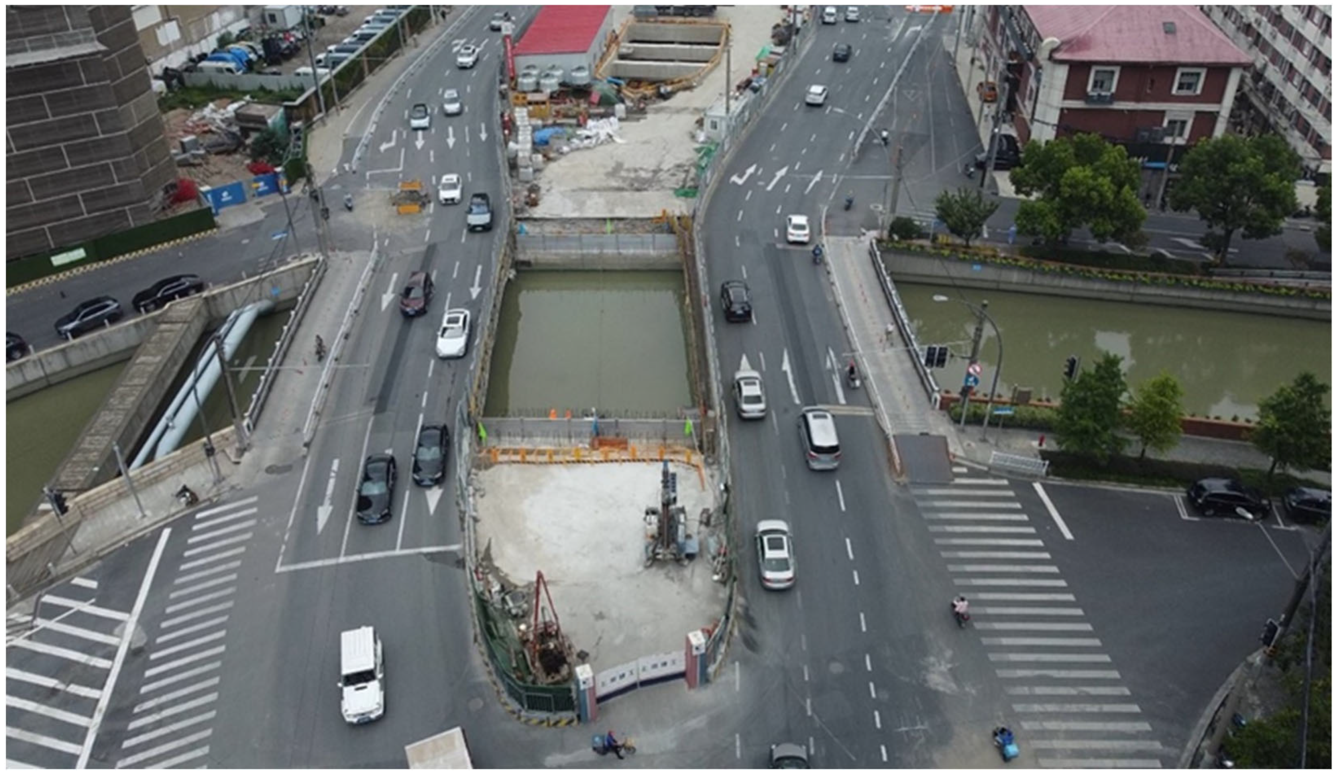
This research is based on an urban tunnel construction project in Shanghai, China, a critical infrastructure initiative aimed at improving urban transportation networks. In this section, the tunnel boring machine (TBM) was launched from a designated shaft and advanced approximately 1486 m (at chainage K13 + 520) to pass beneath a major bridge.
Figure 1 provides an aerial photograph of the tunnel alignment underpassing the bridge.
This area is characterized by a complex urban environment, including not only the bridge but also significant surrounding structures, underground utilities, major urban roadways, protective embankments, and the riverbed of a nearby port. The interaction between shield tunneling activities and these urban structures poses significant risks related to ground settlement, structural integrity, and potential disruptions to underground utilities.
During the construction process, an unexpected challenge arose when the TBM encountered an unidentified obstacle at the 737th ring of the tunnel lining. The primary manifestation of this issue was the blockage of the slurry circulation suction port, which disrupted the normal operation of the TBM. This disruption led to excessive ground surface settlement within the construction enclosure and abnormal settlement of the riverbed. These incidents posed significant risks to the surrounding infrastructure, including the stability of the bridge, nearby buildings, and underground pipelines, highlighting the critical need for effective monitoring and emergency management during tunnel construction in densely populated urban areas.
3. Methodology
3.1. Overview
This study develops a digital twin and knowledge graph-based framework to enhance emergency response strategies for mitigating tunneling-induced disturbances to surrounding buildings and infrastructure. As illustrated in
Figure 2, the methodology consists of two key components: scene/data element integration and digital twin and knowledge graph development.
First, the scene and data elements were systematically collected and integrated, encompassing TBM operational parameters, tunnel structural data, road conditions, surrounding buildings, bridges, and underground utilities. To be specific, the TBM operational parameters included shield tunneling parameters, i.e., thrust force, hydraulic pressure, advance rate, cutterhead torque, rotation speed, stroke length, and tail seal pressure. The data acquisition frequency for these parameters was set at 1 Hz, which ensured sufficient temporal resolution for capturing dynamic variations during tunneling. All the sensor data underwent standard preprocessing procedures, including noise filtering and outlier removal. The error margins of the key sensors used in the system were in the range of ±2%. These elements were further enriched with detailed tunnel–building–pipeline interaction parameters, historical construction records, and real-time monitoring data (e.g., settlement measurements, ground deformation, and environmental conditions). This comprehensive dataset ensured a holistic representation of the urban subsurface environment and its dynamic interactions during tunnel construction.
Second, the multi-source dataset was utilized to develop a digital twin model, which served as a real-time visualization and simulation platform. This model enabled continuous tracking of tunnel construction progress, dynamic assessment of its impact on adjacent infrastructure, and predictive analysis of potential risks. Concurrently, a knowledge graph was constructed to establish semantic relationships between key infrastructure components, risk factors, and emergency response mechanisms. The knowledge graph integrates domain-specific knowledge, regulatory standards, and expert insights, providing a structured framework for risk identification and decision-making.
Finally, the integrated framework was applied to engineering risk warning and emergency response. By leveraging the real-time capabilities of the digital twin and the contextual reasoning of the knowledge graph, the system provided early warnings of potential risks, such as excessive settlement or structural damage, and supported the formulation of optimized emergency response strategies.
It should be noted that the proposed framework was designed to be modular and flexible, allowing for the integration of additional computational components. For instance, machine learning-based predictive models can be incorporated to complement the knowledge graph reasoning. Time-series forecasting models (e.g., LSTM networks) may be used to predict trends in ground settlement or TBM parameters, while classification or anomaly detection algorithms could assist in identifying early warning signals from real-time monitoring data. These ML modules can enhance the framework’s adaptability, support data-driven decision-making, and increase its robustness in handling noisy or incomplete input.
3.2. Digital Twin Establishment
The establishment of the digital twin was based on the framework proposed by Tao Fei et al., which defines a digital twin as
MDT = (
PE,
VE,
Ss,
DD,
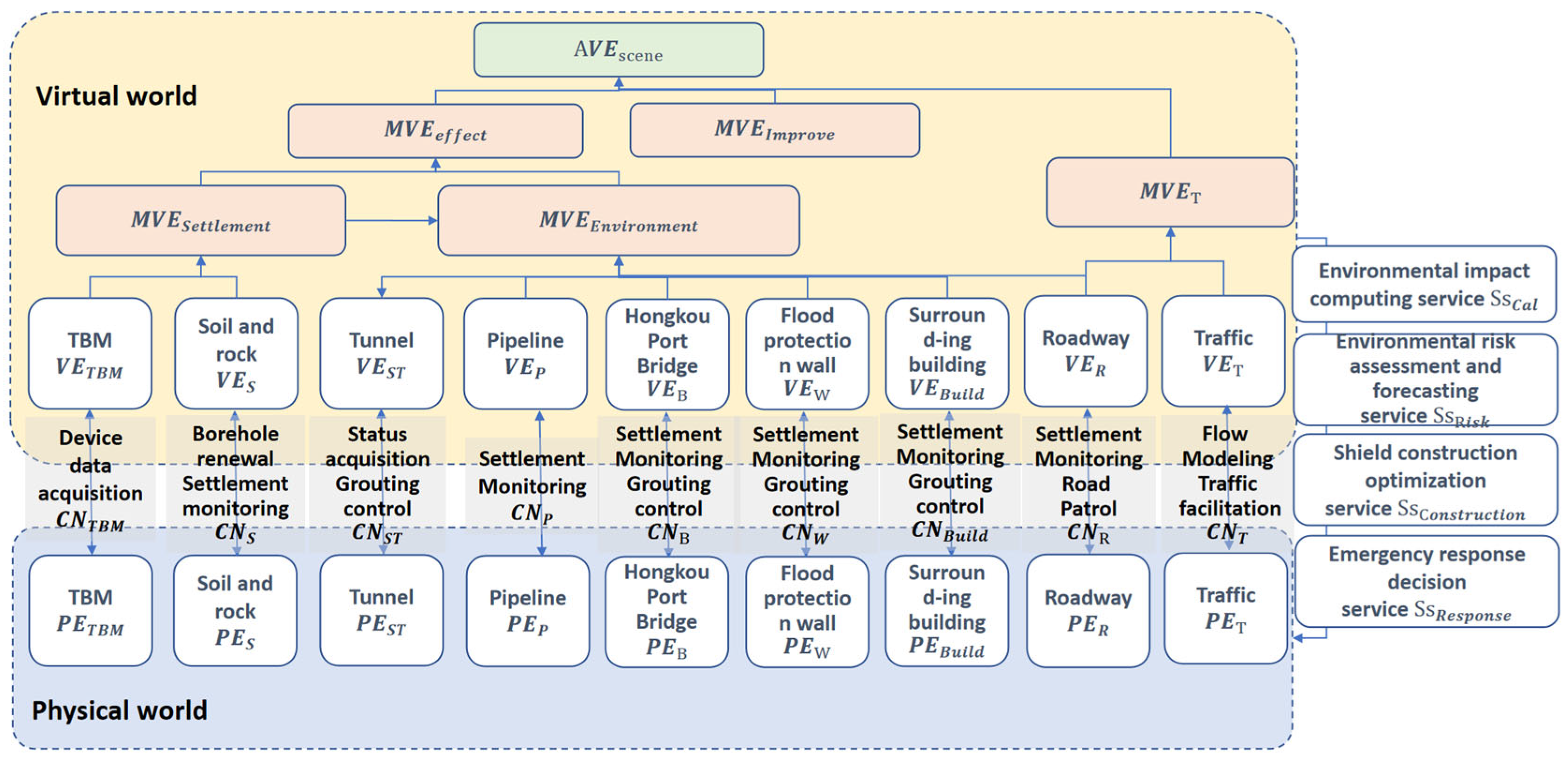
CN). Here, PE represents the physical entities; VE denotes the virtual entities; Ss refers to the services; DD represents the twin data; and CN describes the connections between the components. As illustrated in
Figure 3, the digital twin framework was constructed with a comprehensive set of physical entities, including the TBM, geotechnical soil and rock mass, tunnel structure, underground pipelines, Hongkou Port Bridge, flood protection walls, surrounding buildings, roadways, and traffic systems. Each of these physical entities had a corresponding virtual entity in the digital twin, creating a seamless mapping between the physical and virtual worlds.
The CN between the physical and virtual entities enables real-time data exchange and control. For instance, CN_TBM facilitates TBM data acquisition and operational control; CN_Geotechnical handles borehole data updates, settlement monitoring, and grouting control; while CN_Traffic manages traffic flow modeling and optimization. These connections ensure that the digital twin remains synchronized with the physical environment, providing a dynamic and accurate representation of the tunneling process.
Building upon the individual digital twin models (or single-entity digital twins), a system-level digital twin model was established to capture complex interactions and systemic behaviors. This included the MVE_Settlement virtual entity for soil displacement induced by TBM excavation, the MVE_Effect virtual entity for TBM construction–environmental impact–risk assessment, the MVE_Environment virtual entity for environmental impact under soil displacement fields, the MVE_Improve virtual entity for grouting reinforcement and environmental resilience enhancement, the MVE_Traffic virtual entity for “road-traffic” traffic management, and the AVE_Scene virtual entity for TBM construction–environmental impact–emergency response. These system-level virtual entities enable a holistic understanding of the interactions between tunneling activities and the surrounding environment.
The analysis results from the virtual world were fed back to the physical world through four key services: the Ss_Cal service for environmental impact calculation, the Ss_Risk service for environmental risk assessment and prediction, the Ss_Construction service for TBM construction optimization, and the Ss_Response service for emergency response decision-making. Together, these services ensured that the digital twin not only monitored and simulated the tunneling process but also provided actionable insights for risk mitigation and emergency response, enhancing the overall safety and efficiency of the project.
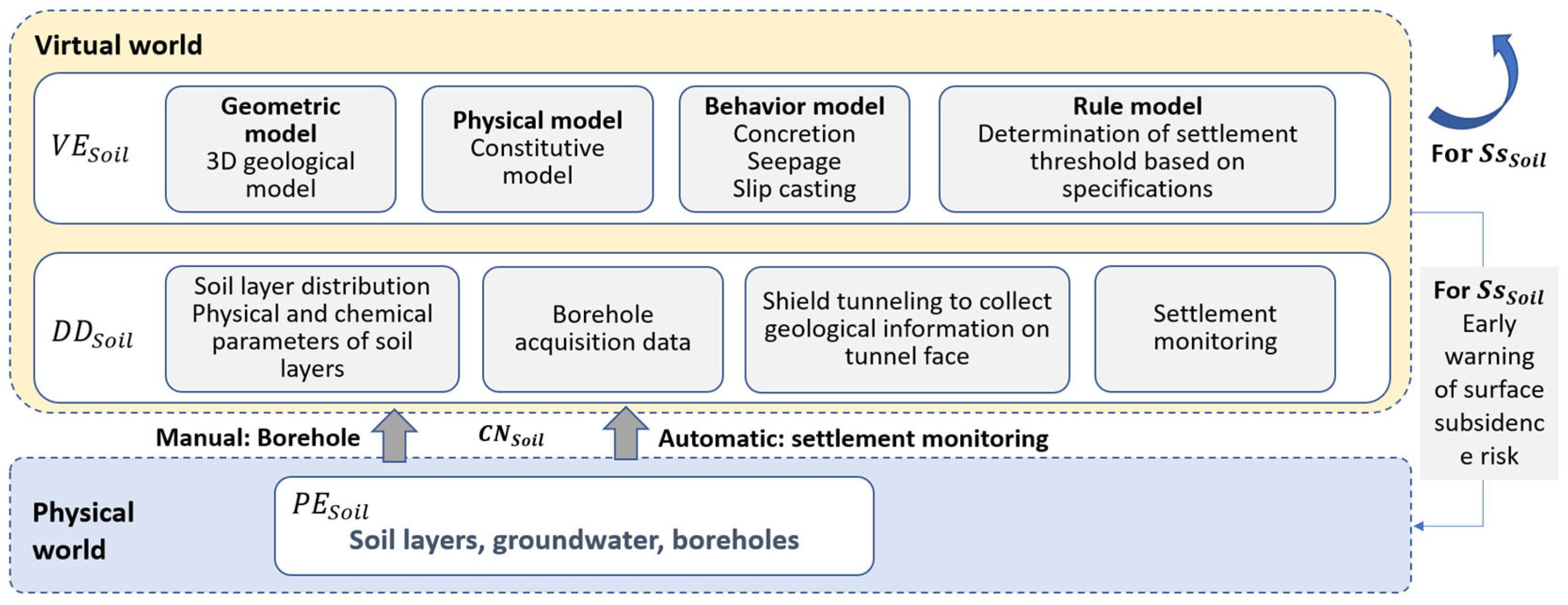
Figure 4 presents the development of a single digital twin model in this study, which takes the geotechnical soil and rock mass as an example. The development of the digital twin model for geotechnical soil and rock mass involved the systematic integration of real-world data collection, virtual modeling, and predictive risk assessment, as illustrated in
Figure 4. In the physical world, geotechnical conditions are represented by soil layers, groundwater, and boreholes (PE_Soil). Through a combination of manual and automated data acquisition methods, a comprehensive dataset (DD_Soil) was collected, encompassing soil layer distribution, physical and chemical properties, borehole acquisition data, geological information obtained from shield tunneling at the tunnel face, and settlement monitoring data. These multi-source datasets formed the foundation for creating corresponding virtual entities in the digital twin. Within the virtual world, a geometric model was constructed as a 3D geological representation of the subsurface conditions, while a physical model was established to capture the constitutive behavior of soil and rock masses. Additionally, a behavior model was integrated to simulate key geotechnical processes such as concretion, seepage, and slip casting, ensuring that the digital twin accurately represented real-world dynamics. To further enhance predictive capabilities, a rule-based model was implemented to determine settlement thresholds based on engineering specifications and historical data. The interplay between the physical and virtual worlds enabled real-time monitoring, analysis, and prediction of ground settlement risks. Ultimately, the analytical results from the virtual world contributed to the generation of Ss_Soil, a surface settlement risk early warning system, which enhances decision-making and proactive risk mitigation strategies in tunneling projects.
3.3. Knowledge Graph Construction
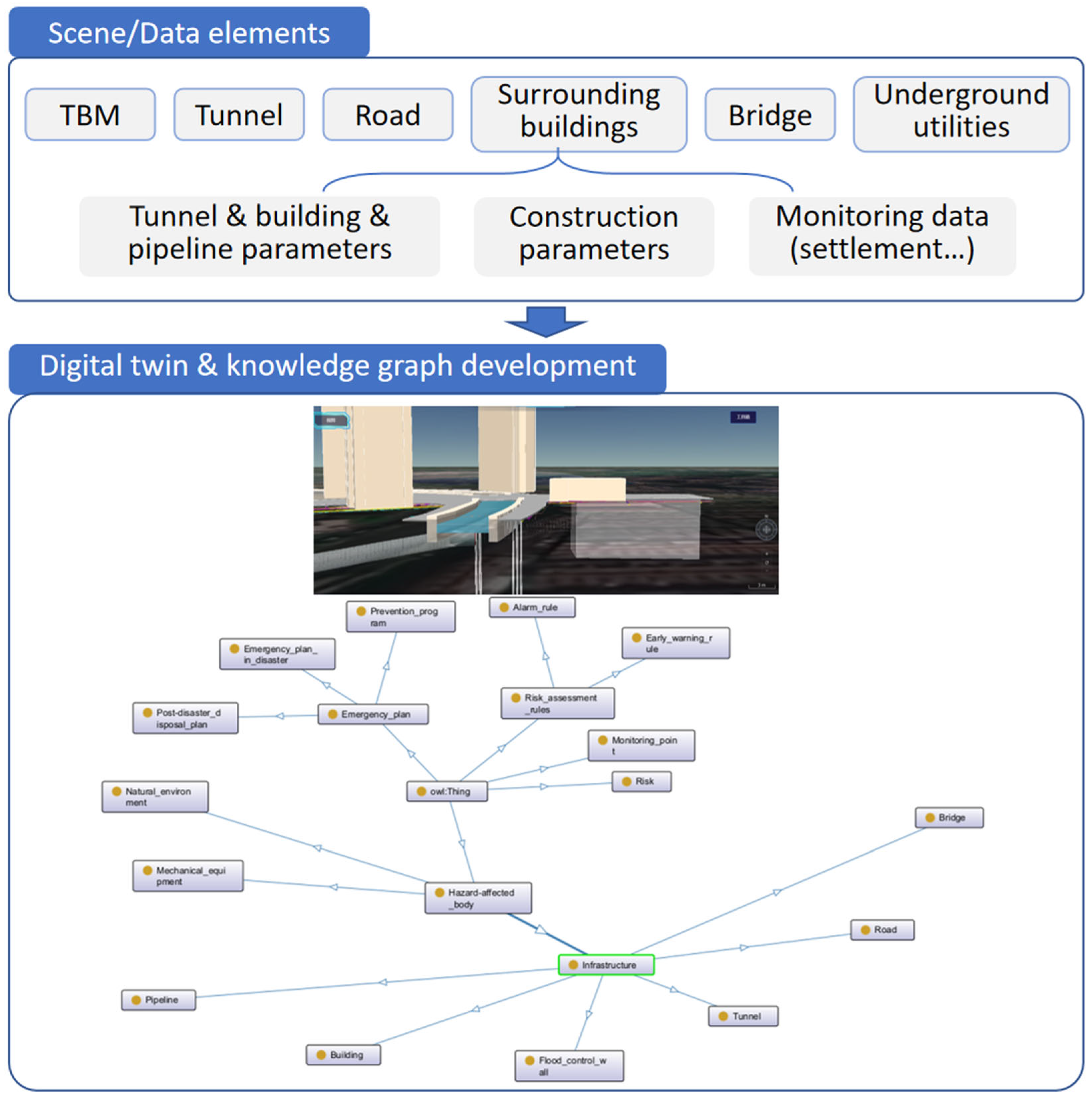
To construct a knowledge graph for tunneling-induced geotechnical risk assessment, this study adopted Stanford’s Seven-Step Methodology, a widely recognized framework for ontology development. This approach ensures a systematic, structured, and scalable representation of key entities, relationships, and rules governing the interactions between tunneling activities, geological conditions, structural responses, and emergency response measures. The seven steps include determining the domain and scope, considering reuse, enumerating important terms, defining classes and hierarchy, establishing properties, creating instances, and finally evaluating and refining the ontology. By following this methodology, the knowledge graph effectively integrates multi-source data, including geotechnical properties, tunneling parameters, structural integrity data, and risk mitigation strategies, enabling a comprehensive semantic representation of the domain.
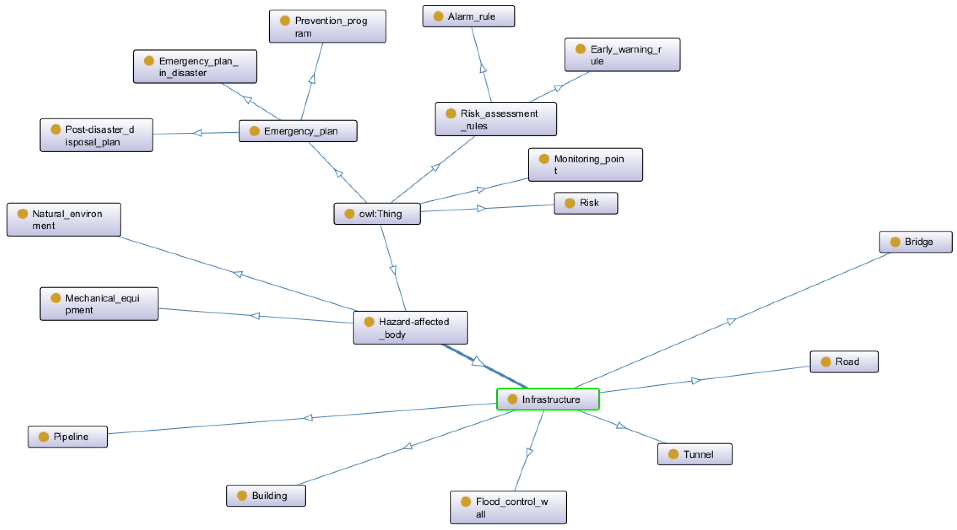
For ontology modeling and implementation, Protégé was employed to construct and manage the knowledge graph structure. The developed ontology encompassed key entities and their hierarchical relationships, enabling a structured representation of geotechnical risks and emergency response mechanisms. As shown in
Figure 5, the ontology consisted of several primary categories, including emergency response plans, bearing structures, monitoring points, and risk assessment rules. The emergency response plan category was further subdivided into preventive measures, emergency response during disasters, and post-disaster handling strategies, ensuring a comprehensive framework for risk mitigation. The bearing structures category included critical infrastructure elements such as buildings, bridges, pipelines, roads, retaining walls, and tunnels, representing the physical entities affected by tunneling activities. Additionally, mechanical equipment and the natural environment were incorporated to reflect their roles in geotechnical stability.
The ontology also integrated monitoring points and risk assessment rules, which are essential for real-time hazard identification and mitigation. Within the monitoring system, risk indicators were explicitly defined to facilitate automated risk evaluation and early warning mechanisms. The risk assessment rules category included reporting and early warning regulations, enabling standardized procedures for assessing and responding to potential settlement and structural instability. By capturing these multi-layered relationships, the knowledge graph provides a semantic foundation for automated reasoning, intelligent decision support, and dynamic risk assessment in urban tunnel construction.
To enhance automated reasoning and intelligent risk assessment, the Semantic Web Rule Language (SWRL) was employed to define inference rules within the ontology. SWRL enables the system to reason over structured data and trigger alerts when predefined settlement thresholds are exceeded. For example, in accordance with standard regulations, the settlement criteria included a maximum cumulative settlement of 24 mm, a maximum cumulative uplift of 8 mm, and a maximum settlement rate of 2.4 mm/day. These thresholds were defined based on domain expert input and empirical rules derived from historical data. These conditions can be encoded into SWRL rules as follows:
These rules define conditions in which the settlement, uplift, or settlement rate exceed regulatory limits, triggering a corresponding early warning mechanism. When real-time monitoring data are input into the ontology, the SWRL engine automatically evaluates these thresholds and generates alerts if a violation occurs.
To ensure reliable inference within the knowledge graph, all the input data were first semantically standardized and validated during ingestion. The reasoning system applied SWRL rules over this structured knowledge base, where rule execution was conditioned on the completeness of the required input fields. In cases in which the input data were incomplete, the corresponding rules were not triggered, and the instance was flagged for further review. This prevented the generation of false or misleading inferences. At present, conflicting data entries (e.g., contradictory sensor readings) are not automatically resolved by the system; however, the framework supports rule modularity, allowing for the future integration of uncertainty-aware reasoning mechanisms or confidence-weighted rules. These capabilities are planned for subsequent development to enhance reasoning robustness under uncertain or ambiguous data conditions.
3.4. The Integration of Digital Twin and Knowledge Graph
The integration of the digital twin and the knowledge graph establishes a dynamic, data-driven framework for intelligent risk assessment and decision-making in urban tunnel construction. The digital twin continuously integrates real-time field data, including settlement monitoring, TBM parameters, and structural response measurements, to create a virtual representation of the physical tunneling environment. This real-time synchronization enables the digital twin to provide an up-to-date visualization of the tunnel and its surrounding infrastructure, facilitating the immediate detection of abnormal conditions and potential risks.
The knowledge graph, on the other hand, enhances the analytical and reasoning capabilities of the system. The field data collected by the digital twin are transferred to the knowledge graph, where predefined rules, semantic reasoning, and SWRL inference mechanisms are applied to assess risk levels, determine potential hazard patterns, and suggest mitigation strategies. Once the reasoning results are generated, the knowledge graph feeds them back to the digital twin, where they are visually represented in an interactive environment. This bidirectional data exchange enables a seamless integration of real-time monitoring, intelligent reasoning, and visualization, providing construction engineers with actionable insights for proactive risk mitigation.
Through this synergistic interaction, the digital twin and the knowledge graph work together to transform raw data into structured knowledge and intelligent predictions. The digital twin serves as the interface for real-world monitoring and visualization, while the knowledge graph provides a cognitive layer that enriches decision-making through rule-based inference, semantic querying, and predictive analysis. This integration not only improves situational awareness but also enables automated and intelligent emergency response strategies, enhancing the safety and sustainability of urban tunnel construction.
4. Implementation
4.1. Development of the Digital Twin Platform
To effectively integrate real-time monitoring, knowledge-driven reasoning, and interactive visualization, a digital twin platform is developed as the central hub for data fusion, simulation, and decision support in urban tunnel construction. The platform integrates multi-source data from geotechnical monitoring, TBM operations, structural sensors, and environmental conditions, providing a high-fidelity virtual representation of the tunneling environment. By continuously updating with real-time field data, the digital twin serves as a dynamic simulation environment, allowing engineers to track tunnel progress, assess structural responses, and detect potential risks as they emerge.
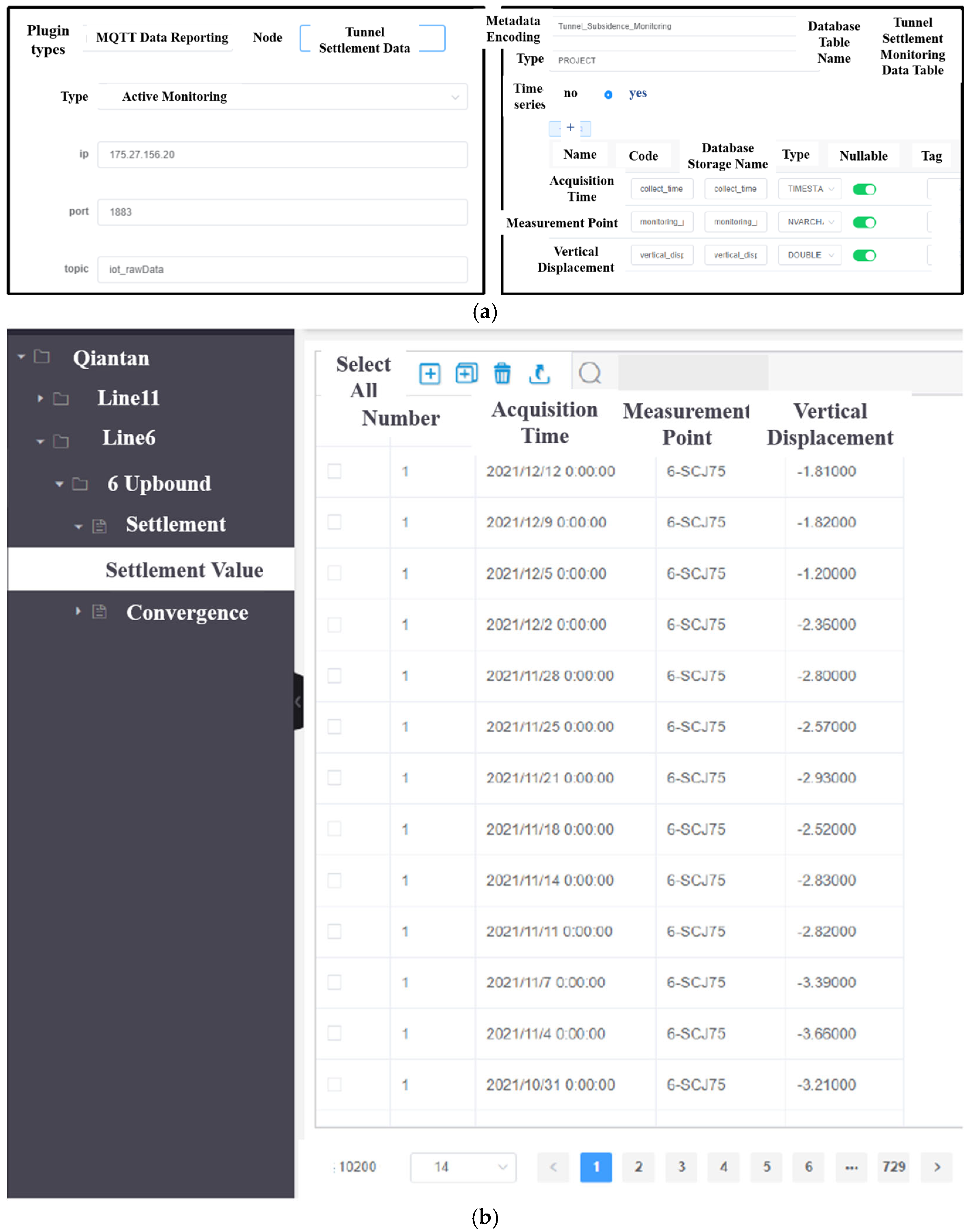
The integration between the digital twin platform and the knowledge graph is supported by a real-time data fusion and semantic mapping pipeline developed on top of the iS3 platform. Monitoring devices (e.g., ground settlement sensors) transmit high-frequency data using the MQTT protocol (
Figure 6a), ensuring lightweight and low-latency communication. These messages are published to specific topic channels via the platform’s message broker module. Upon reception, the system unpacks the raw messages and performs semantic standardization, in which each data field is mapped to a unified schema with structured labels and ontology-aligned attributes based on a predefined data model. This ensures cross-platform interpretability and consistency.
As shown in
Figure 6, the standardized data are then archived into a structured database, forming the basis for dynamic knowledge graph reasoning. This mechanism enables the digital twin to maintain synchronization with physical site conditions, allowing for real-time updates and near-instantaneous triggering of risk alerts. The end-to-end process—from data acquisition to semantic integration and storage—ensures that monitoring data are transmitted, processed, and analyzed with both high frequency and reliability, supporting continuous alignment between the real and virtual environments.
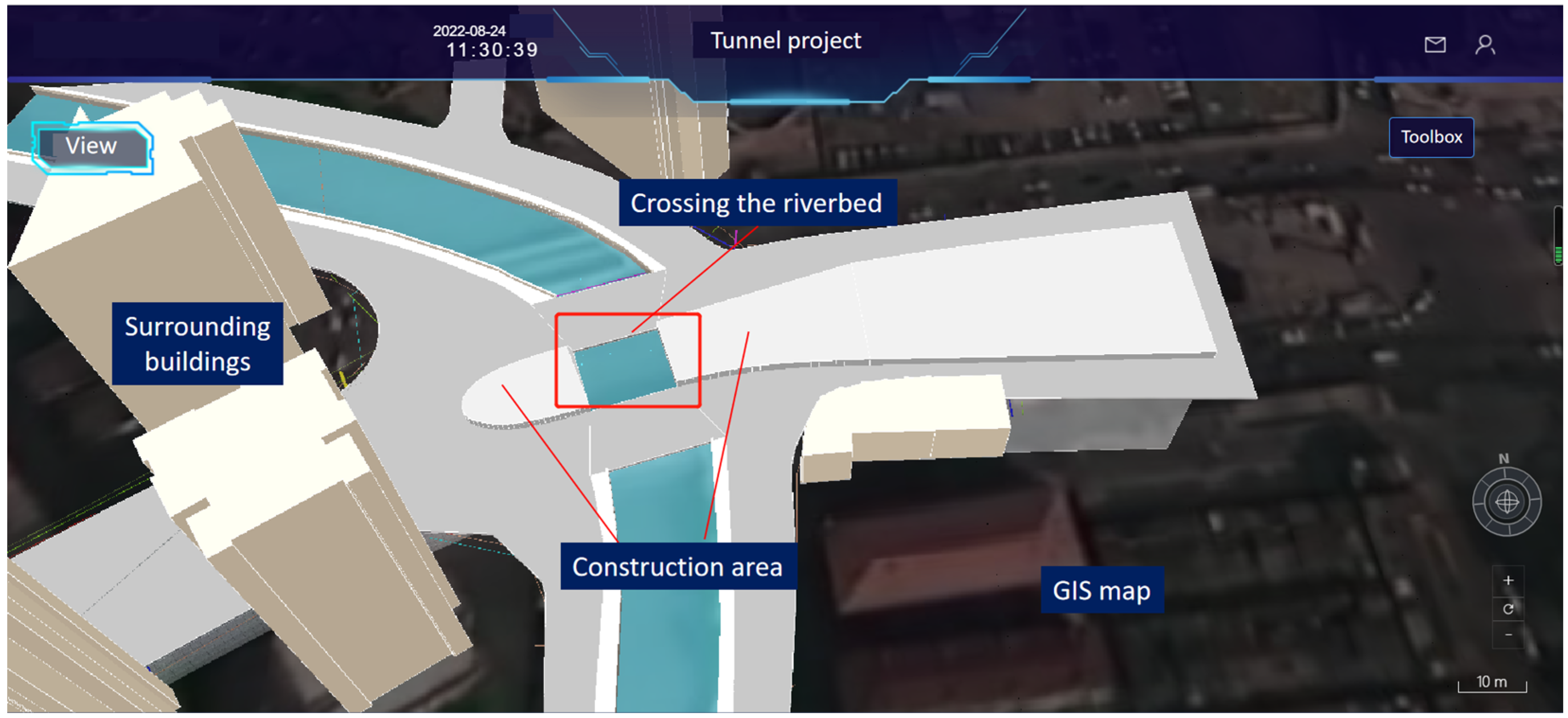
Figure 7 illustrates the interface of the developed digital twin platform, which visualizes the tunnel project in its real-world spatial context. The platform integrates three-dimensional BIM models of the surrounding buildings, geographic map, and critical infrastructure within the project area, including detailed modeling of rivers, roads, and other key urban elements. Key infrastructure elements are annotated for intuitive navigation, and users can access real-time data through the interface for location-specific risk monitoring and decision support.
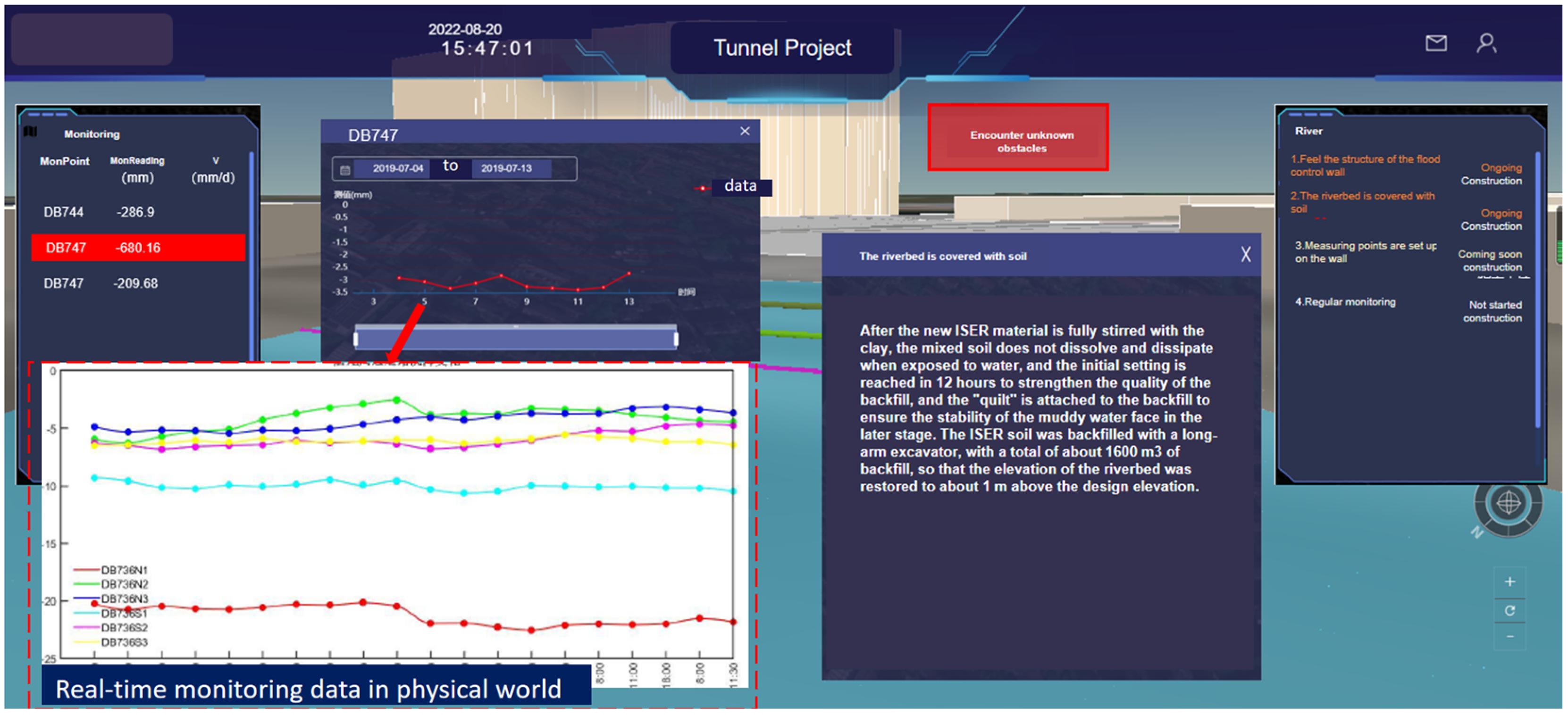
The developed digital twin platform demonstrated robust capabilities in real-time data integration and visualization, as evidenced in
Figure 8. The left panel enumerates key monitoring points established for the project, including the DB744 and DB747 monitoring points, while the central section displays temporal monitoring data trends for a representative point (DB747). Notably, the lower-left visualization presents the extracted monitoring data from engineering reports, demonstrating the platform’s ability to automatically integrate and display real-time field measurements. This functionality enables the continuous monitoring of critical parameters including ground settlement, structural deformation, and environmental impacts.
4.2. Emergency Response Based on Digital Twin and Knowledge Graph
The digital twin platform enables intelligent emergency response by integrating real-time monitoring data with knowledge graph-based rule reasoning. As systematically documented in
Table 1, the knowledge graph incorporates domain-specific rules that establish quantitative relationships between various monitoring parameters and potential excavation-induced risks. When the platform processes continuous sensor data through these predefined rules, it automatically identifies and classifies emerging risks with high precision.
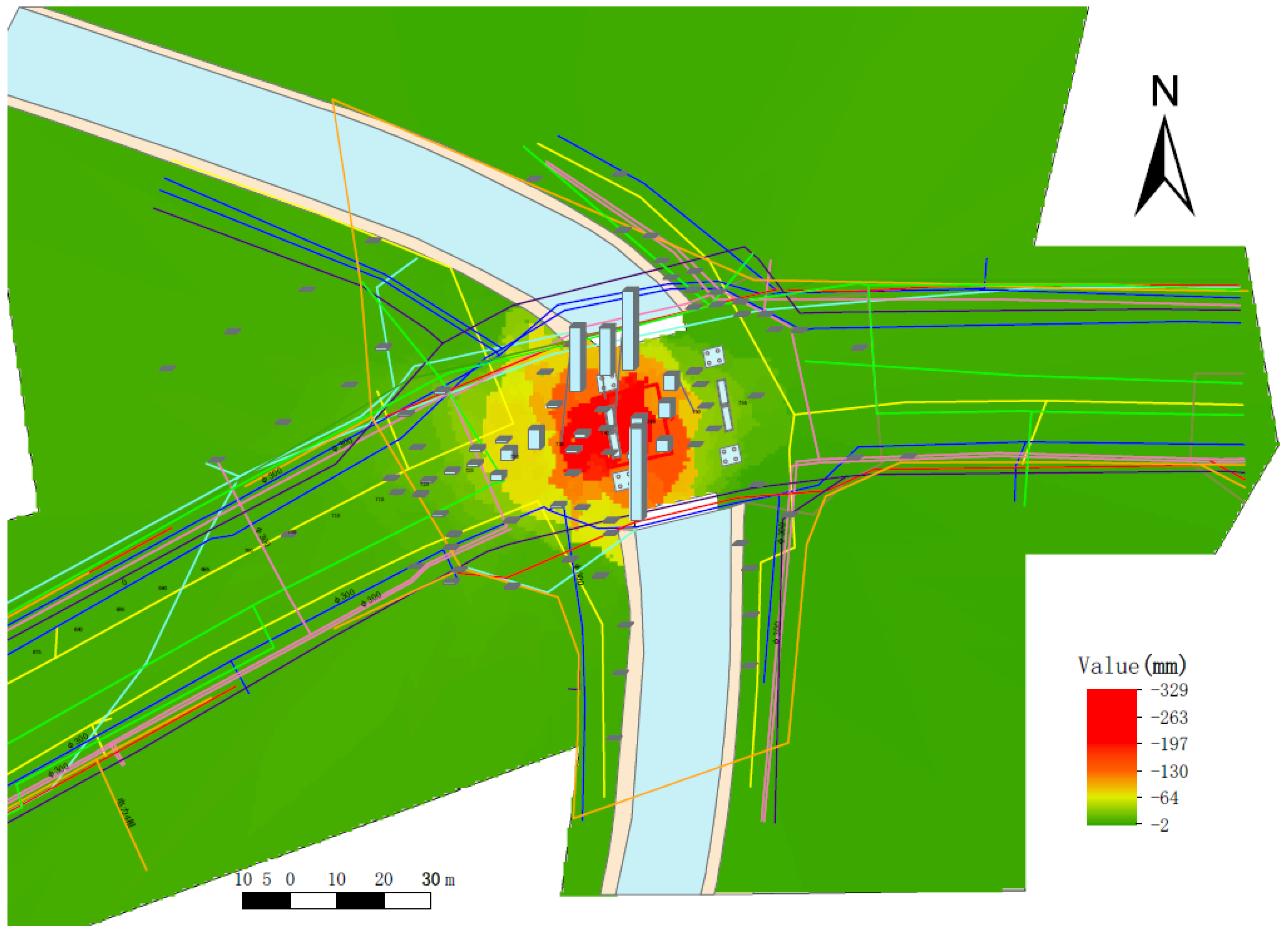
Figure 9 demonstrates the platform’s analytical capabilities through comprehensive visualization outputs. The settlement cloud map provides a spatial representation of the ground deformation patterns, while the accompanying histogram visualizations offer a quantitative analysis of the settlement distribution characteristics. These dual visualization modalities enable engineers to quickly assess both the geographical extent and severity of the excavation impacts.
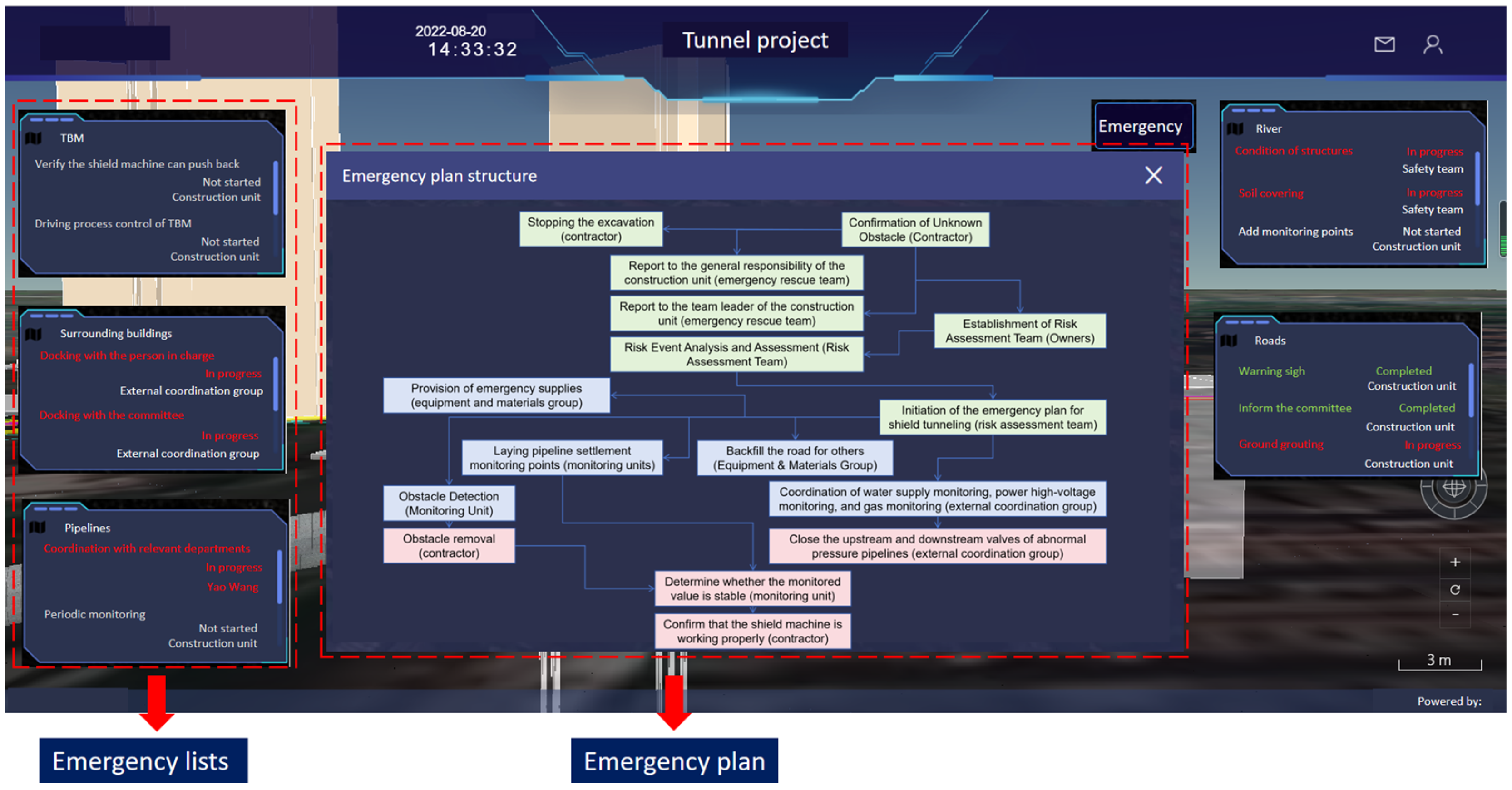
Building on the identified risks in
Figure 8,
Figure 9 illustrates the structured emergency response mechanism developed within the proposed framework. This response mechanism is composed of two core components: the central emergency organizational structure and the corresponding emergency action plans on either side. The central structure outlines how various stakeholders—including the construction team, monitoring unit, risk assessment team, emergency intervention unit, and external coordination group—should collaborate in the event of an emergency. Each group has clearly defined responsibilities, ensuring that all the aspects of risk mitigation and emergency handling are covered efficiently and systematically.
The left and right sections of
Figure 10 present targeted emergency action plans based on the real-time conditions and knowledge graph-derived risk points. These plans describe how specific elements within the digital twin—such as pipelines, retaining structures, and buildings—should be assessed or acted upon. For instance, the external coordination group is responsible for contacting building owners in surrounding areas; the construction team is tasked with adding monitoring points to nearby pipelines, inspecting the current structural state of floodwalls and bridges, and performing grouting operations in affected surface zones. The status of each task is represented using color codes: red indicates ongoing actions; green represents completed tasks; and yellow denotes actions that are scheduled to begin. The middle part of
Figure 10 illustrates the structured emergency response workflow designed for tunnel construction scenarios involving unknown obstacle detection or abnormal monitoring events. The process begins with the immediate suspension of excavation and confirmation of the risk event, followed by hierarchical reporting to responsible parties and the establishment of a dedicated risk assessment team. Based on the risk evaluation, an emergency response plan is initiated, involving coordination among multiple groups—including monitoring units, equipment teams, and external coordination bodies—for tasks such as backfilling, utility shutdowns, obstacle detection, and pipeline monitoring. The digital twin platform supports this process by enabling real-time data access and visualization at each decision point, thereby enhancing the efficiency and clarity of emergency management operations.
This coordinated approach allows for the definition of interdepartmental responsibilities, enabling each team to operate within its designated domain. By leveraging ontology-based reasoning, the system determines the most likely risk sources and automatically delegates relevant tasks to appropriate units. In doing so, the framework facilitates responsive, decentralized, and intelligent emergency management, ensuring that mitigation strategies are both timely and data-informed. This methodology not only improves operational efficiency in high-risk scenarios but also exemplifies how the digital twin–knowledge graph integration can support smart and proactive infrastructure resilience.
The proposed framework enables real-time monitoring and early warning across a range of tunnel construction risk factors, including not only TBM operational parameters (e.g., thrust, pitch, torque) but also external impacts such as ground and building settlement. Through the digital twin platform, all stakeholders—including site supervisors, control room personnel, and project decision-makers—can access a unified, real-time visualization of both internal machine behavior and surrounding structural responses. Alerts are automatically triggered based on data anomalies and risk thresholds, significantly reducing the response time compared with traditional manual inspection and reporting processes. Field feedback from a recent deployment indicates the system achieves high early warning accuracy, particularly in identifying subtle changes in settlement trends that may precede larger structural risks. Although a detailed quantitative comparison with traditional systems is planned for future work, these initial results demonstrate the system’s strong potential in improving risk visibility and operational responsiveness.
5. Discussions
5.1. Implications
Compared with recent studies on digital twins and knowledge graphs in the field of civil engineering, the approach presented in this study offers a notable advancement in the context of intelligent emergency management. While previous research has primarily focused on the use of digital twins for 3D visualisation, progress monitoring, or simulation, and on knowledge graphs for asset information modelling or static data integration, the present framework demonstrates how the two technologies can be dynamically integrated to support real-time risk reasoning and emergency decision-making. By embedding SWRL-based rule logic within a semantically standardised digital environment, the system enables the automatic interpretation of sensor data and the triggering of structured emergency workflows. This knowledge-driven mechanism enhances situational awareness and response coordination beyond what is typically achieved by conventional monitoring platforms or static BIM models.
The potential implications of this research extend beyond tunnel engineering, offering a scalable and transferable framework for various infrastructure projects that require continuous monitoring, risk analysis, and decision support. The bidirectional interaction between the digital twin and knowledge graph ensures that raw sensor data are transformed into structured knowledge, facilitating automated reasoning and intuitive visualization. This integration has the potential to reduce construction risks, improve safety protocols, and optimize maintenance strategies, contributing to the development of smart and resilient urban infrastructure.
Furthermore, this research supports the broader objectives of sustainable and intelligent construction by promoting data-driven decision-making, resource efficiency, and environmental risk reduction. The digital twin platform serves as a foundation for future advancements in AI-driven construction management, enabling cities to adopt more efficient, adaptive, and intelligent infrastructure solutions. By bridging the gap between real-time monitoring and advanced analytics, this study lays the groundwork for the next generation of automated risk management and emergency response systems in complex urban environments.
5.2. Limitations
Despite the advantages of integrating digital twin and knowledge graph technologies for tunnel construction risk assessment, several limitations remain in the current study. One of the primary challenges is the availability, reliability, and quality of real-time data. The accuracy and effectiveness of the digital twin model depend heavily on the completeness, resolution, and frequency of monitoring data—such as ground settlement measurements, TBM operational parameters, and structural responses. In real-world scenarios, issues such as sensor noise, data loss, calibration drift, and communication delays may compromise data quality. These imperfections in the sensor data can introduce uncertainty and bias into the knowledge graph reasoning process, especially when real-time decisions are required. For instance, noisy or incomplete input data may lead to the misclassification of risk levels or delayed responses to emerging hazards. Furthermore, dependencies between different data sources may amplify the effect of local failures or missing values, particularly in complex tunneling environments. Future work will focus on integrating data confidence metrics, robust error-handling mechanisms, and redundancy in sensor networks to improve the resilience of the real-time reasoning framework and reduce the impact of data-related biases.
The ontology and SWRL rule base used in this study were manually constructed based on domain standards and expert knowledge specific to urban tunnel construction in Shanghai. This rule-based approach was adopted to ensure semantic clarity and to demonstrate the feasibility of integrating digital twin and knowledge graph technologies for early warning and emergency management. However, extending the system to other types of infrastructure or geographic contexts would likely require significant manual adaptation of the ontology and reasoning rules, which may limit scalability. Future research could focus on developing automated ontology generation and rule extraction mechanisms, such as through natural language processing or pattern mining techniques, to support more efficient deployment across diverse and dynamic construction environments.
In addition to the limitations discussed, future work will explore the integration of dynamic learning mechanisms within the knowledge graph, enabling the system to continuously adapt its reasoning logic based on incoming data streams and evolving risk patterns. Furthermore, to validate the generalizability of the proposed framework, pilot studies in diverse urban geological settings—such as soft soil, mixed-face, or high-groundwater-level conditions—will be conducted to assess its robustness and transferability across different tunneling environments.
Although the system has been applied in real-world tunnel construction scenarios and has demonstrated good practical performance, a key limitation is the lack of a quantitative evaluation of its technical metrics. Parameters such as reasoning speed, data throughput, and the accuracy of risk predictions have not yet been formally measured or benchmarked. This limits the ability to objectively compare the system’s performance with traditional methods or to assess its scalability under varying data and operational loads. Future work should include comprehensive performance profiling and controlled experiments to support more rigorous validation and facilitate broader adoption.
While the current implementation has been validated in a single tunnel construction project, the potential scalability of the proposed system warrants further discussion. In larger-scale or multi-site scenarios, challenges such as increased sensor density, data throughput, and the complexity of cross-site coordination may arise. The current architecture is designed with a modular and distributed structure, which provides a basis for horizontal scaling. For instance, data ingestion, semantic mapping, and reasoning tasks can be deployed across multiple nodes or edge devices to alleviate central processing bottlenecks. Furthermore, by leveraging the MQTT’s lightweight protocol and topic-based message segregation, the system can support parallel data streams from multiple sources. Future work will involve stress-testing the system under simulated large-scale conditions and exploring scalable graph reasoning strategies to ensure performance in more complex infrastructure contexts.
6. Conclusions
This study presents an integrated framework combining digital twin and knowledge graph technologies to enhance risk assessment and emergency response in urban tunnel construction. By continuously integrating real-time monitoring data with a semantic reasoning system, the proposed approach enables dynamic risk prediction, intelligent decision support, and interactive visualization. The bidirectional interaction between the digital twin and knowledge graph ensures that raw sensor data are transformed into structured knowledge, facilitating automated inference and proactive mitigation strategies for tunneling-induced ground disturbances.
The method has been successfully applied in a practical urban tunnel construction in Shanghai, China. The results demonstrate that this approach improves situational awareness, construction safety, and response efficiency, offering a scalable solution for intelligent infrastructure management. However, limitations such as data availability, computational complexity, and adaptability to unforeseen conditions highlight the need for further advancements. Future research should focus on enhancing machine learning-based reasoning, optimizing system scalability, and expanding real-world validation across diverse geotechnical and urban environments.
By bridging the gap between real-time monitoring and advanced risk analysis, this study contributes to the development of intelligent, sustainable, and resilient urban tunnel construction. The proposed framework not only enhances current risk management practices but also serves as a foundation for future innovations in smart infrastructure and automated emergency response systems.


