Deformation Patterns and Failure Mechanisms of Soft-Hard-Interbedded Anti-Inclined Layered Rock Slope in Wolong Open-Pit Coal Mine


 ,
,
Abstract
1. Introduction
2. Study Area
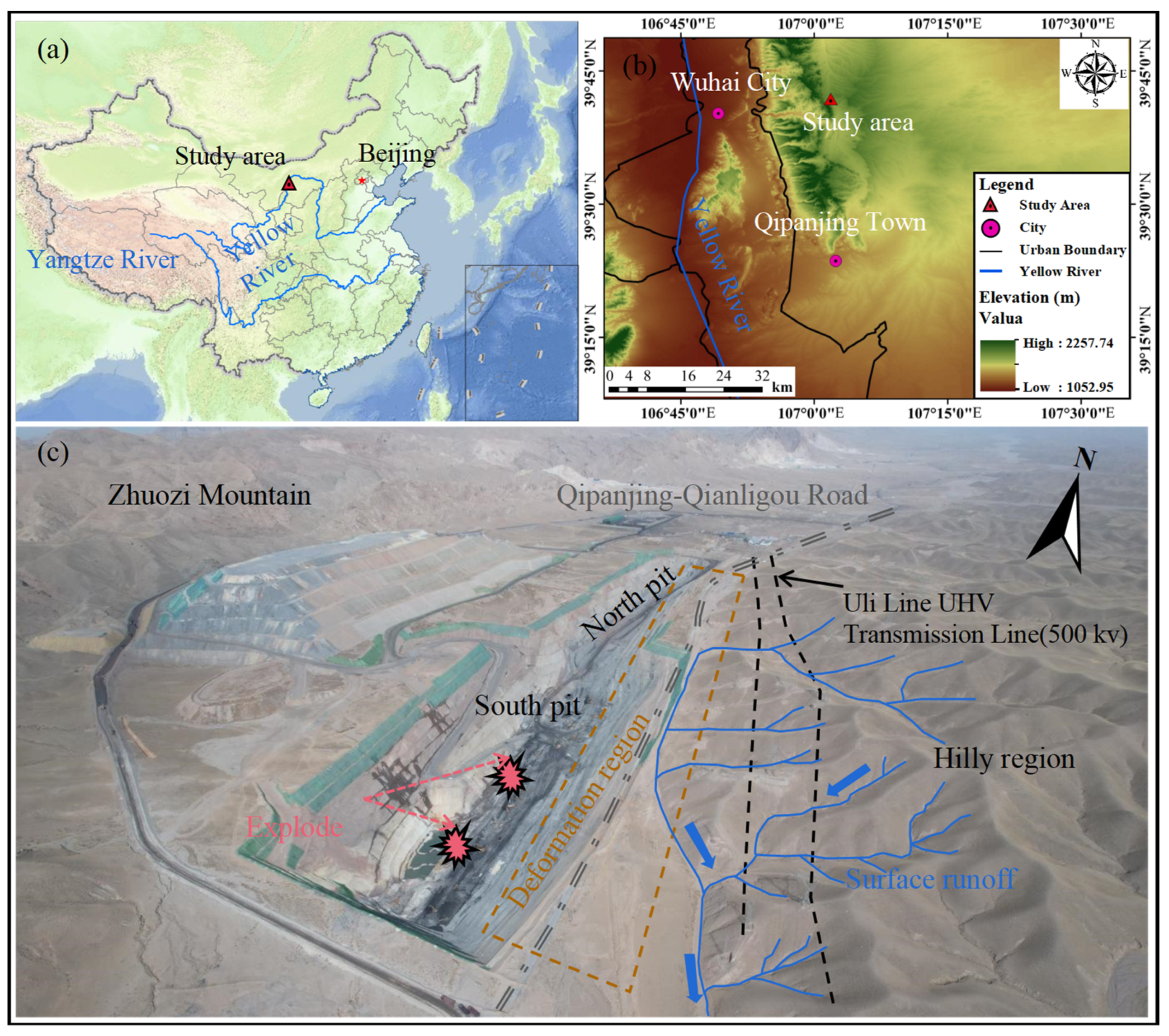
2.1. Overview
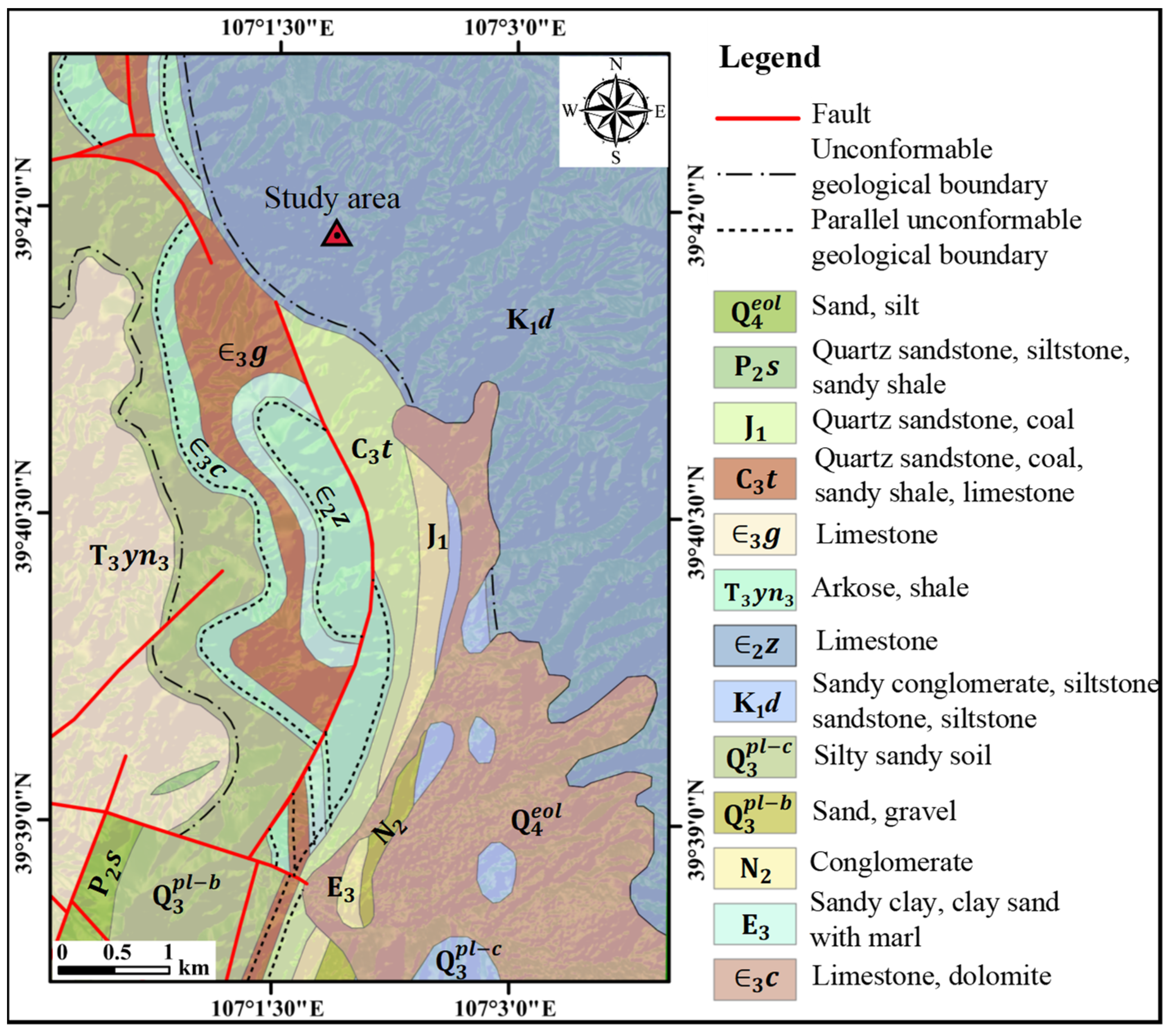
2.2. Geological Setting
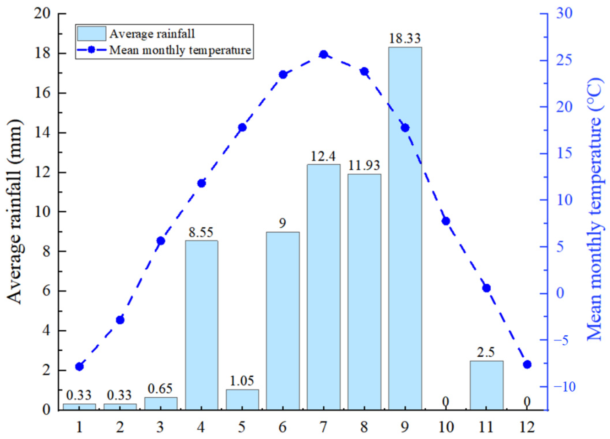
2.3. Meteorology and Hydrology
2.4. Earthquake
2.5. Status of Open-Pit Mining
3. Data and Methodology
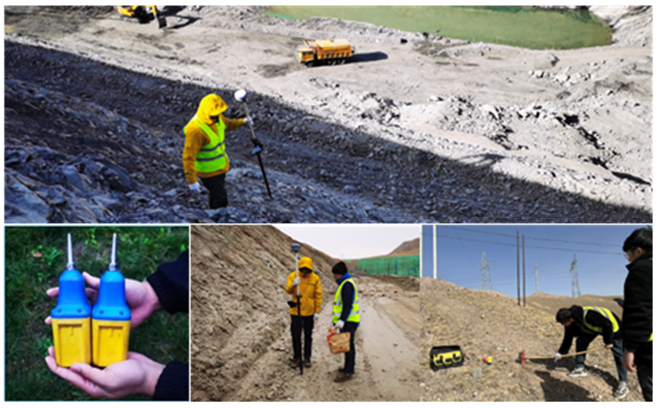
3.1. Geological and Geomorphological Survey
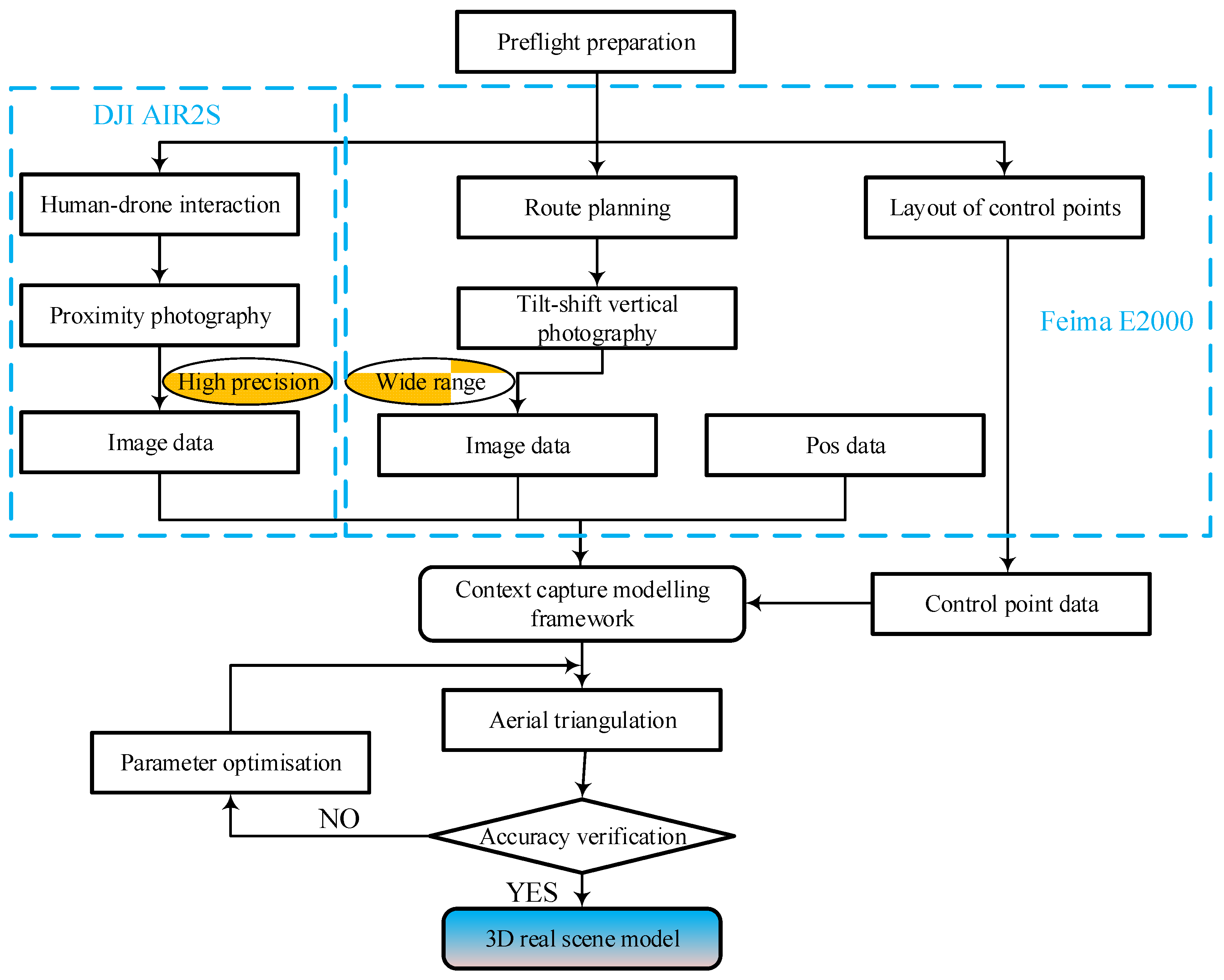
3.2. UAV Photogrammetry Techniques
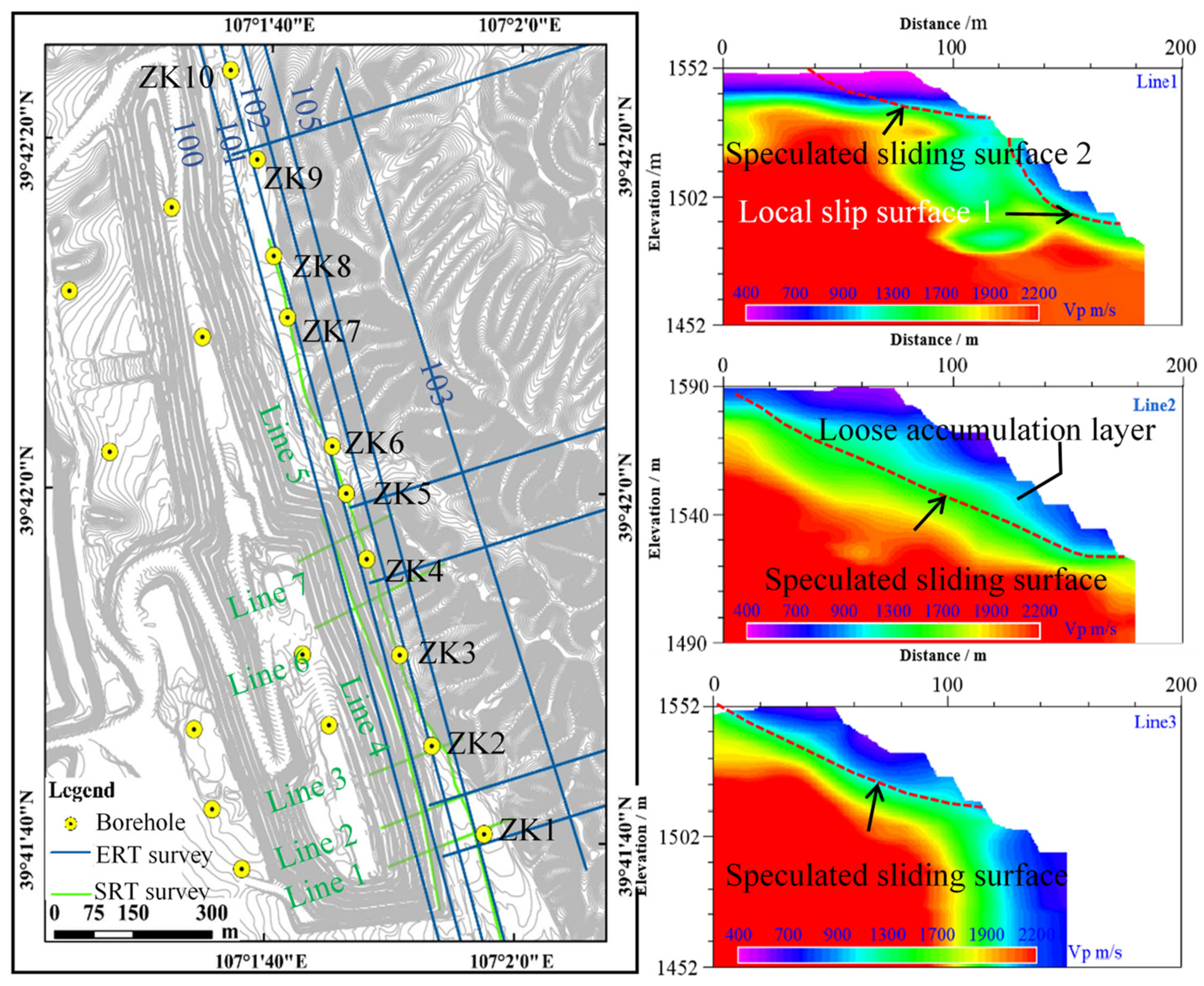
3.3. Integrated Geophysical Exploration Method
3.3.1. ERT Survey
3.3.2. SRT Survey
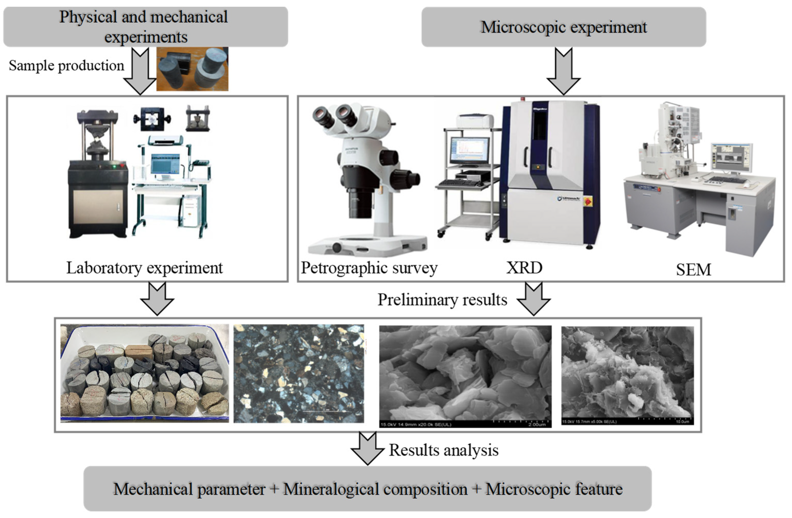
3.4. Laboratory Testing of Rock Masses
3.4.1. Laboratory Physical and Mechanical Tests
3.4.2. Rock Thin Section Analysis
3.4.3. XRD Analysis
3.4.4. SEM Analysis
3.5. Rock Mass Quality Evaluation
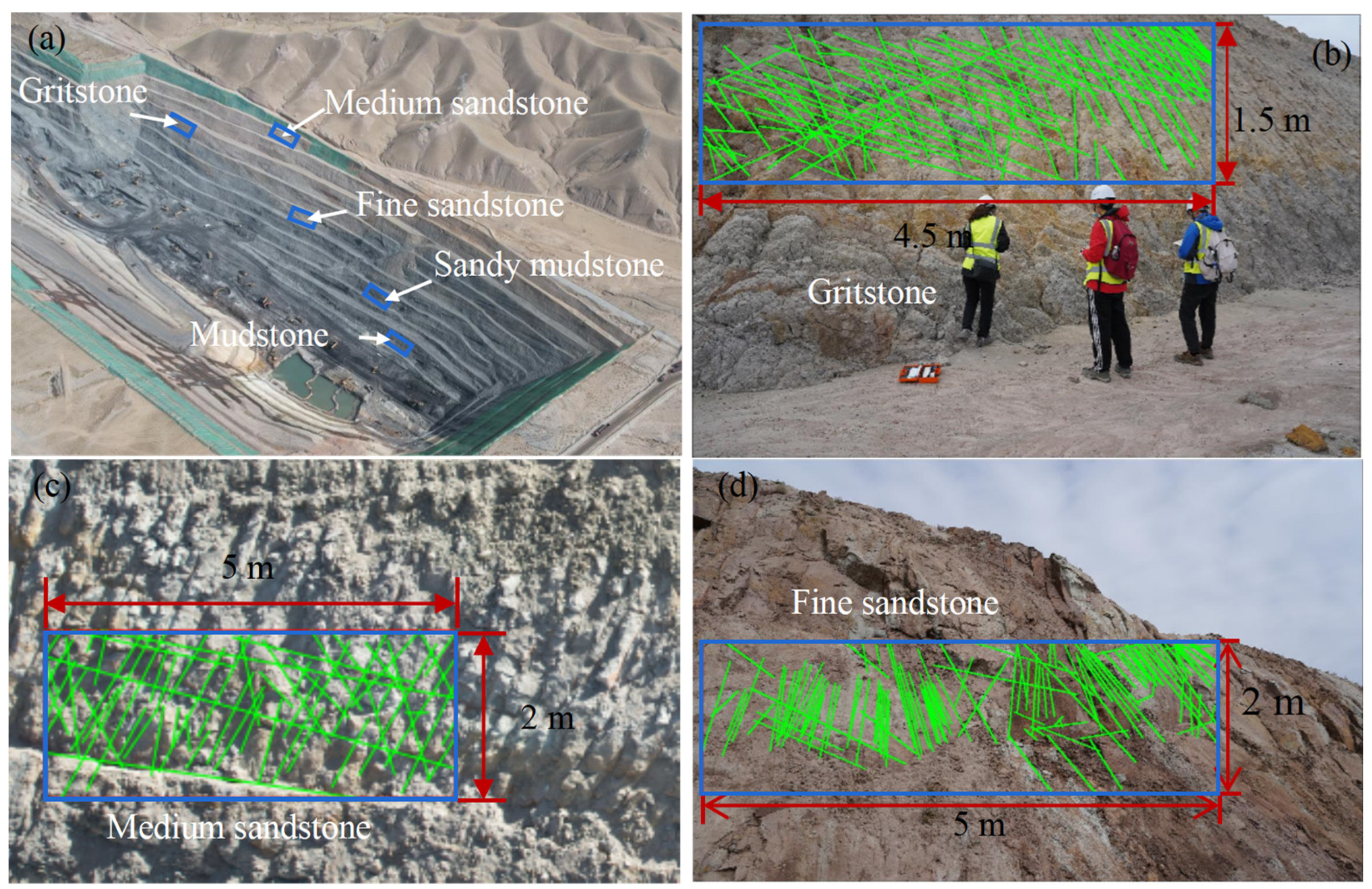
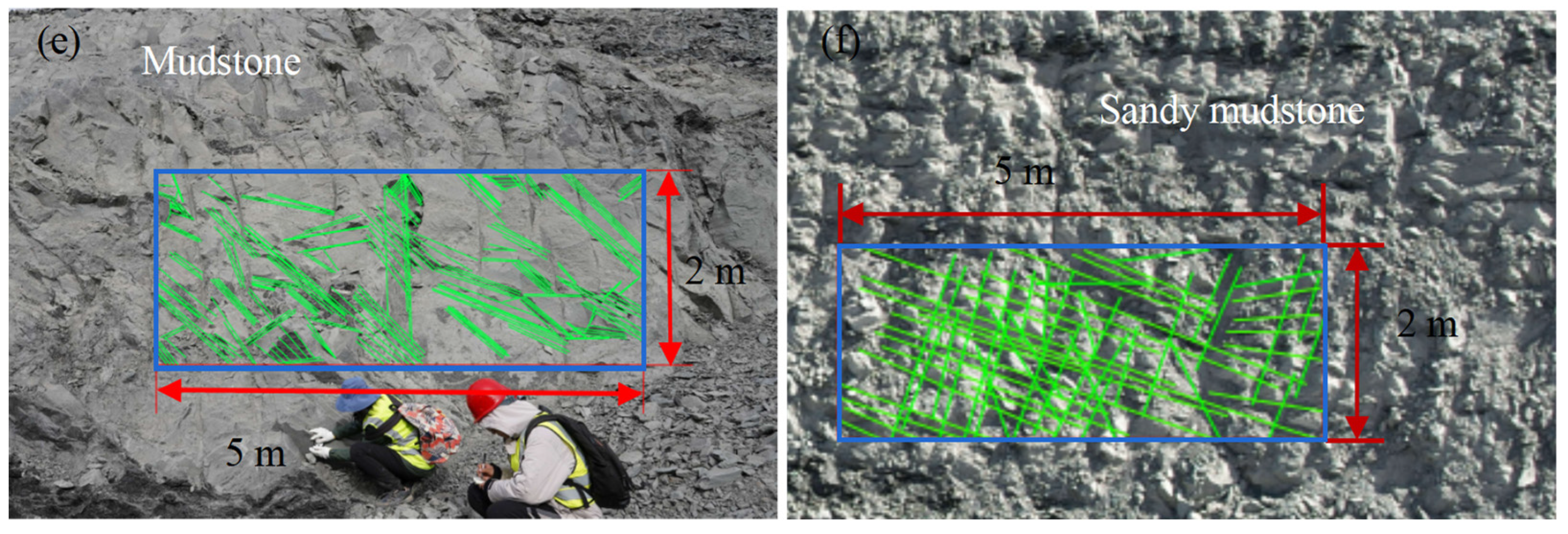
3.5.1. Fracture Data Collection
3.5.2. Rock Mass Quality Evaluation Based on Geological Strength Index (GSI)
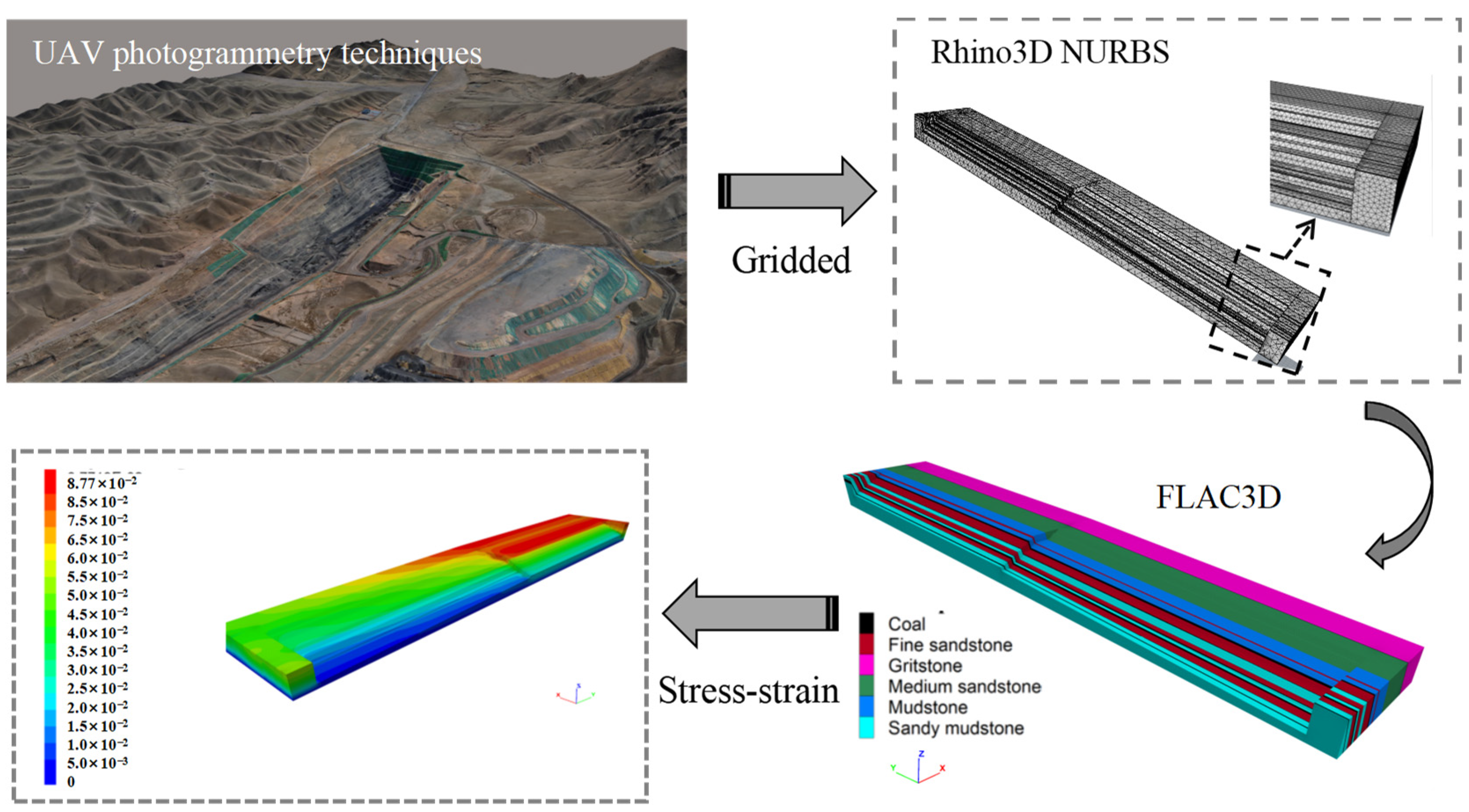
3.6. Numerical Simulation
4. Results
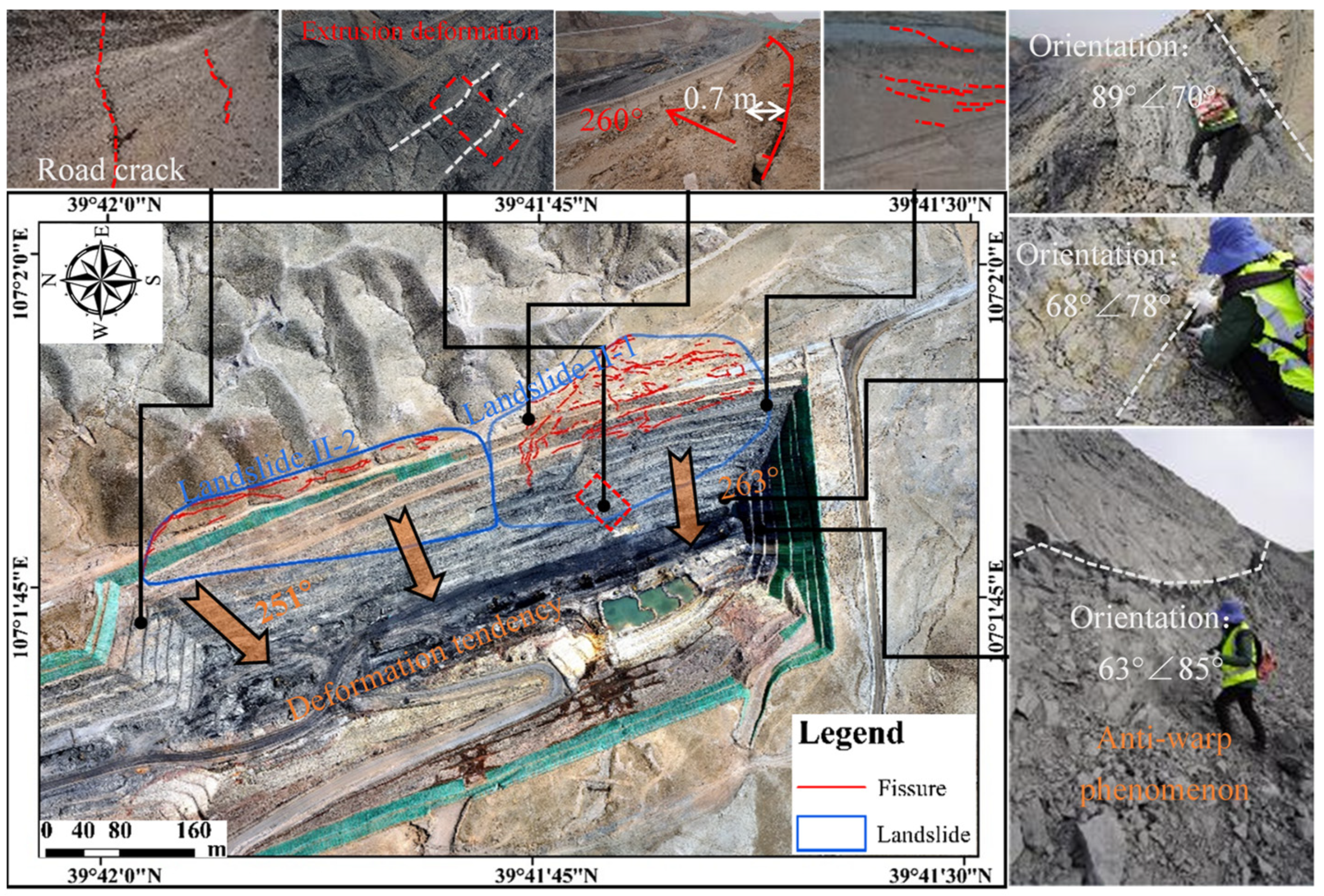
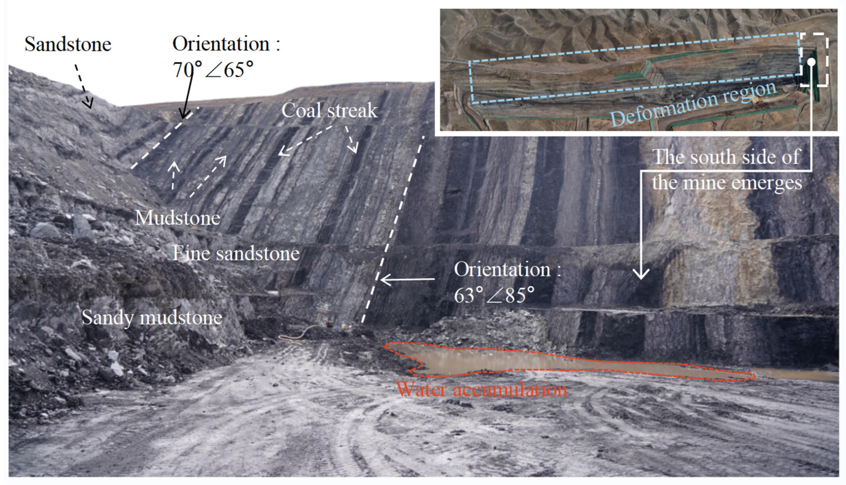
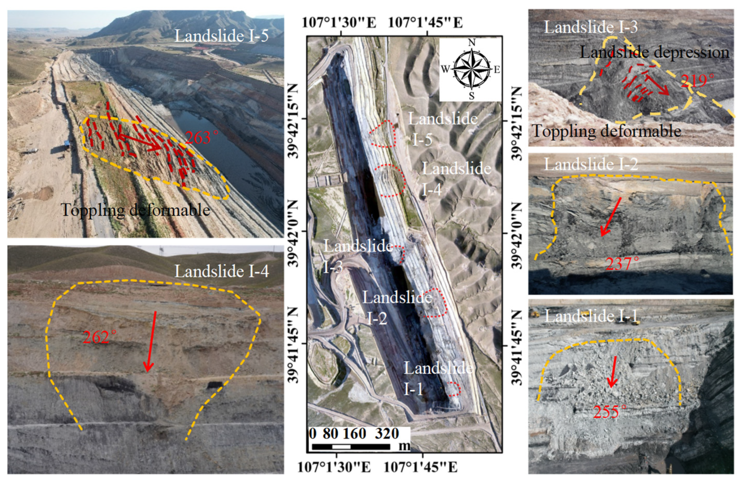
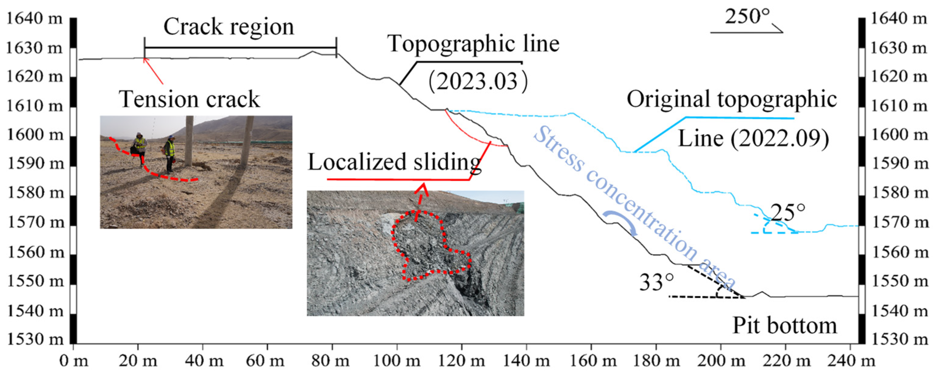
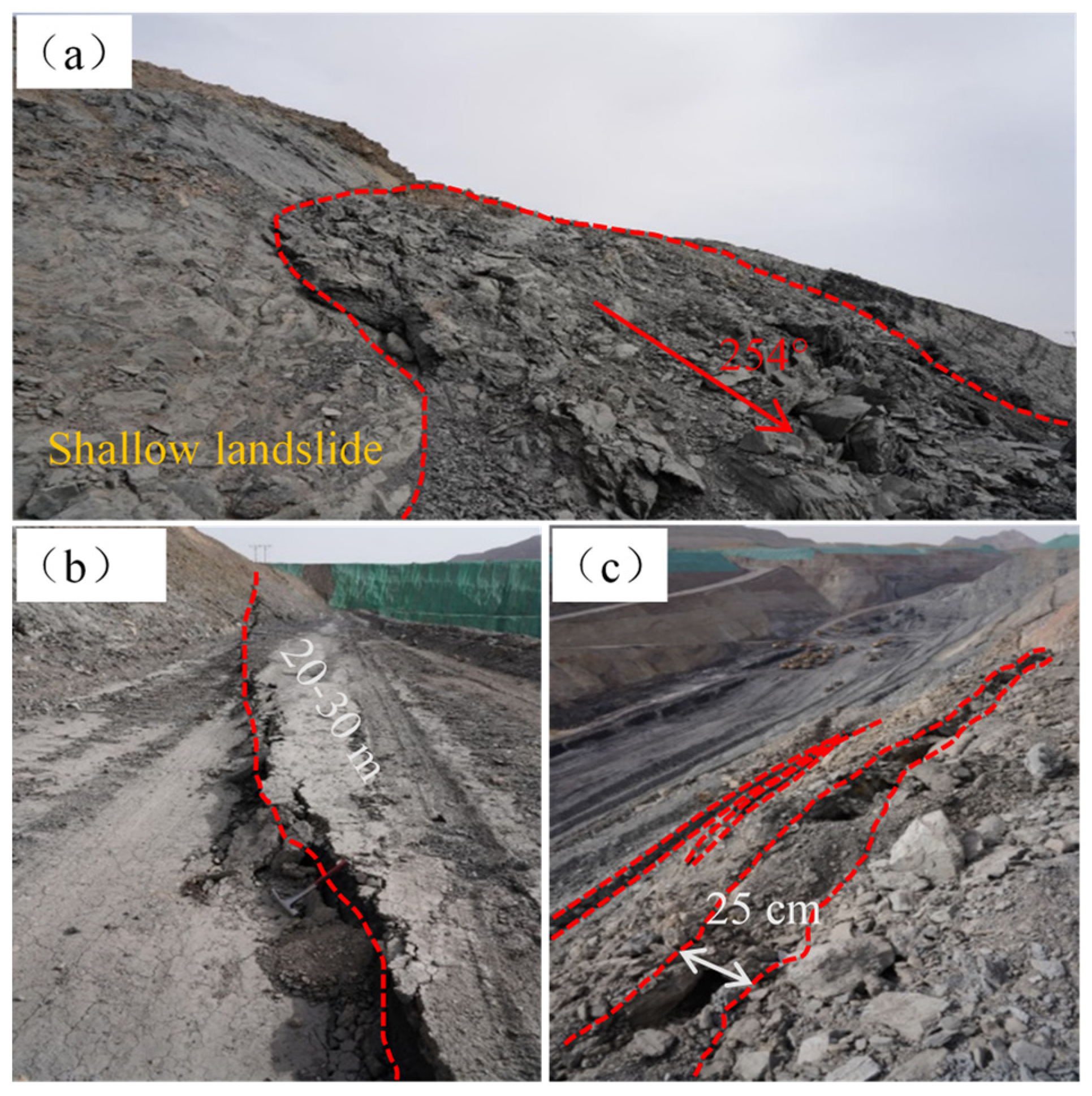
4.1. Characteristics of Landslide Deformation
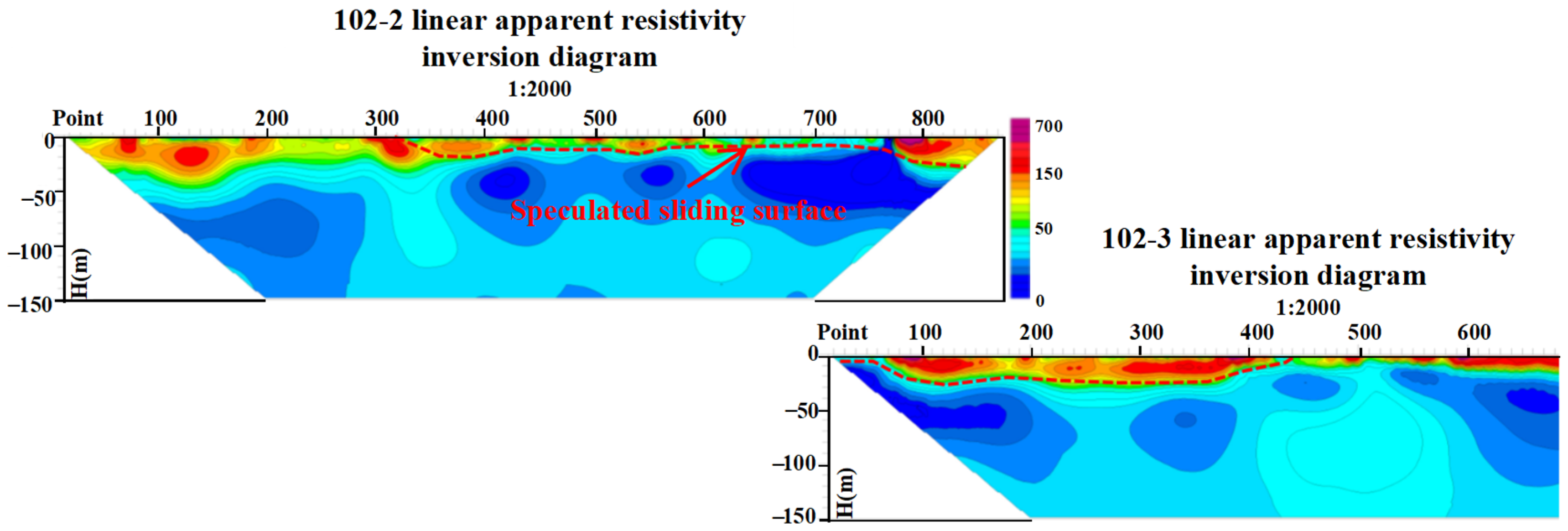
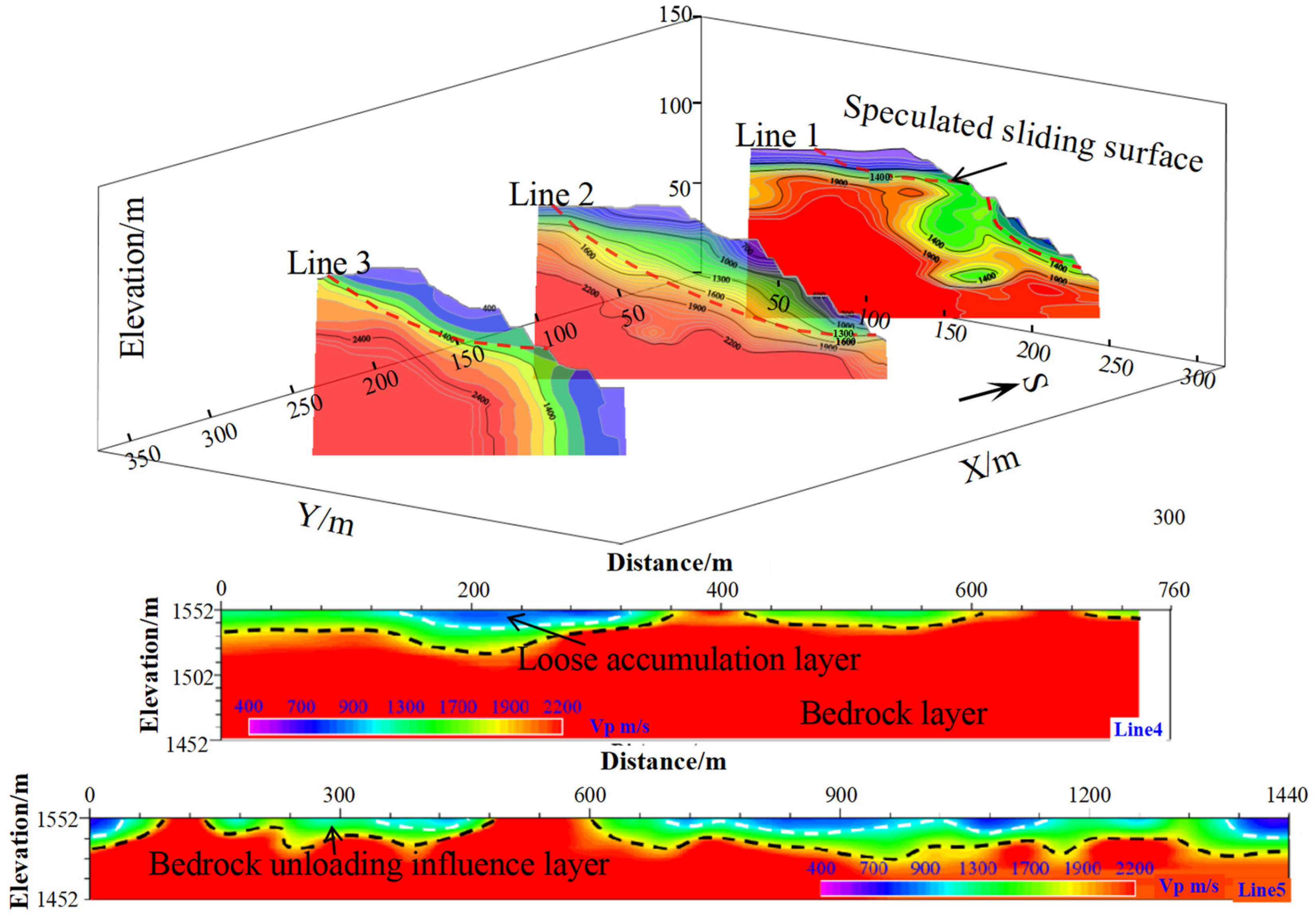
4.2. 3D Geological Structure Model of the Slope in the Mining Area
4.3. Laboratory Testing Results of the Rock Mass
4.3.1. Results of Rock Thin Section Analysis
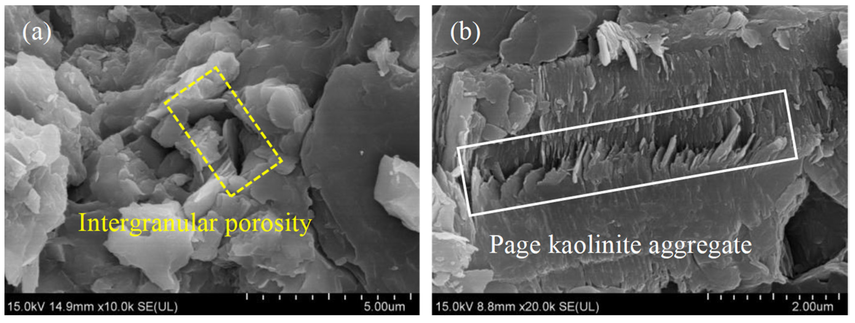
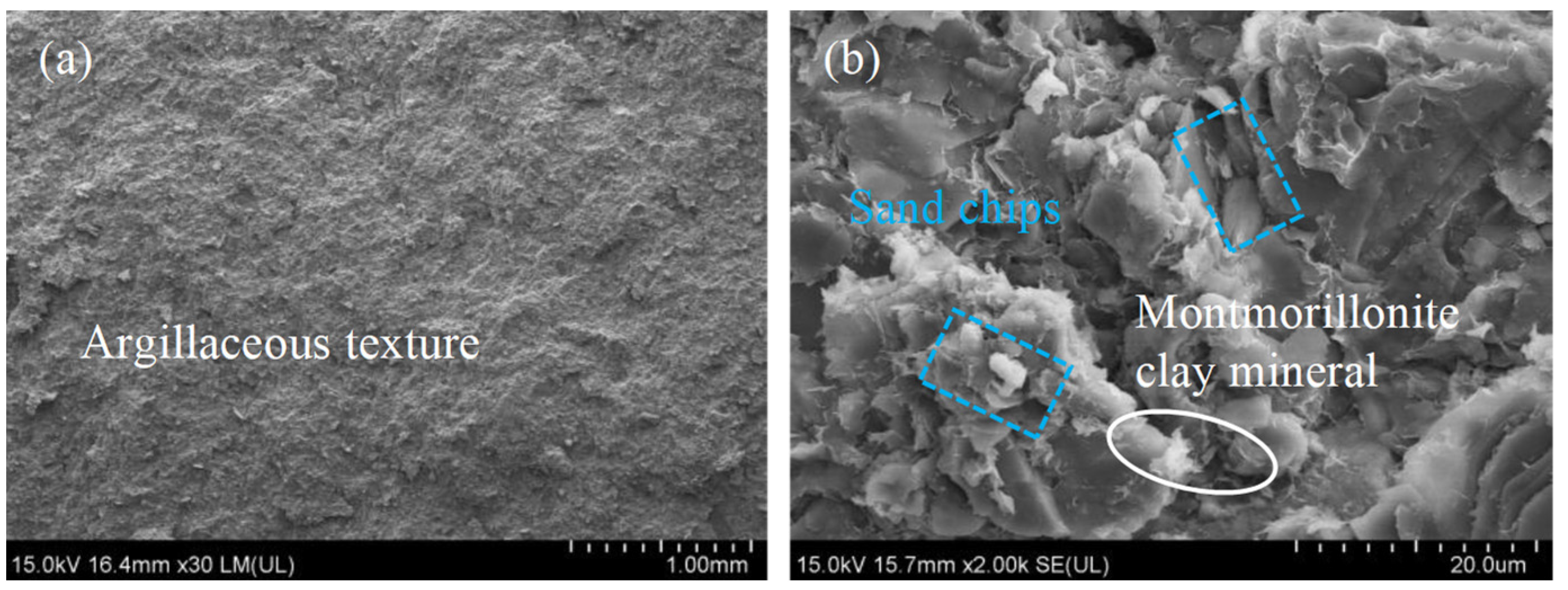
4.3.2. Results of SEM Analysis
4.3.3. Results of XRD Analysis
4.3.4. Results of Laboratory Physical and Mechanical Tests
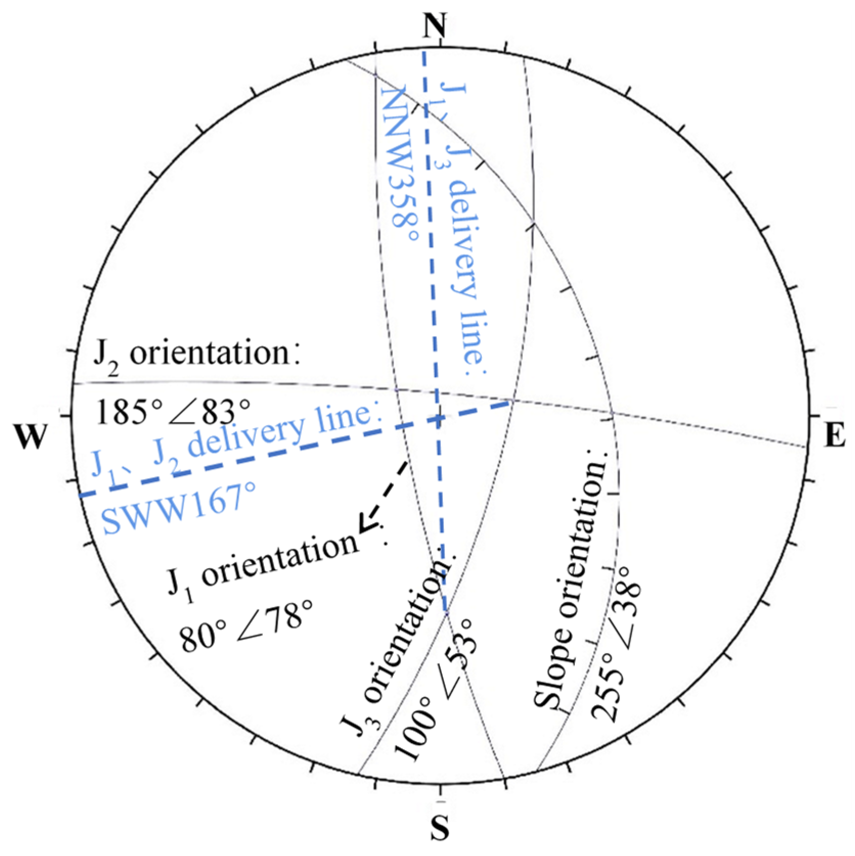
4.4. Rock Mass Structure Characterization
4.5. Numerical Simulation Results of Slope Deformation and Failure
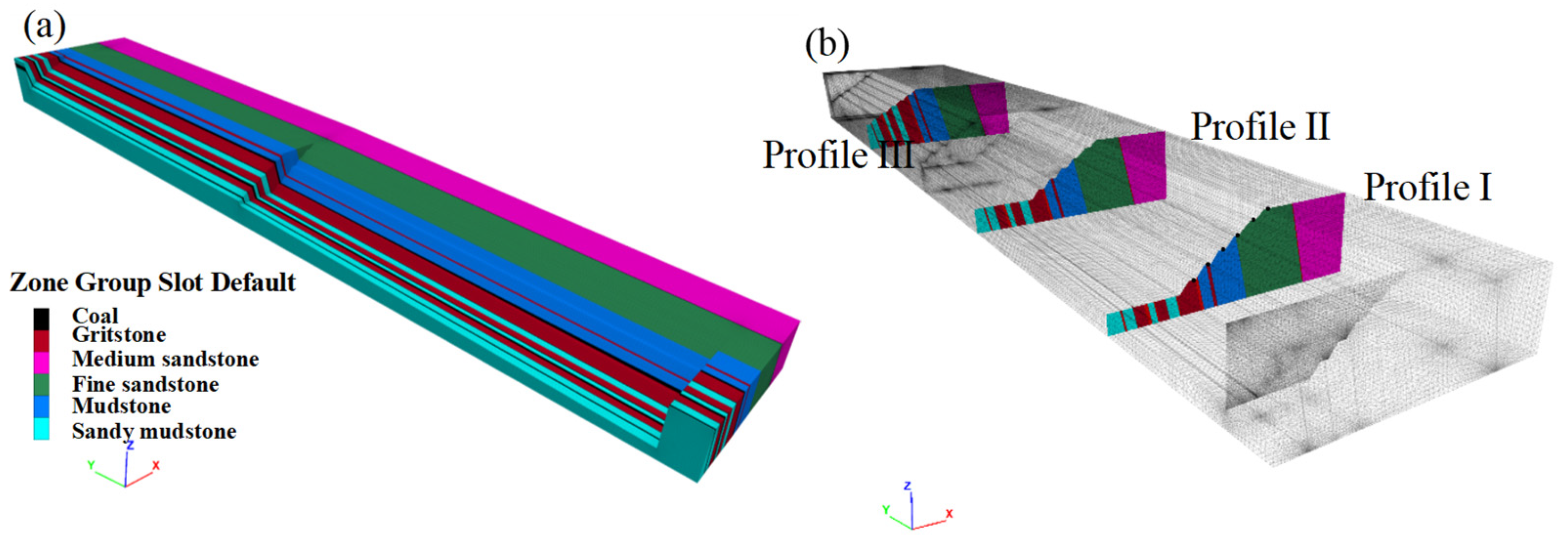
4.5.1. Model Construction
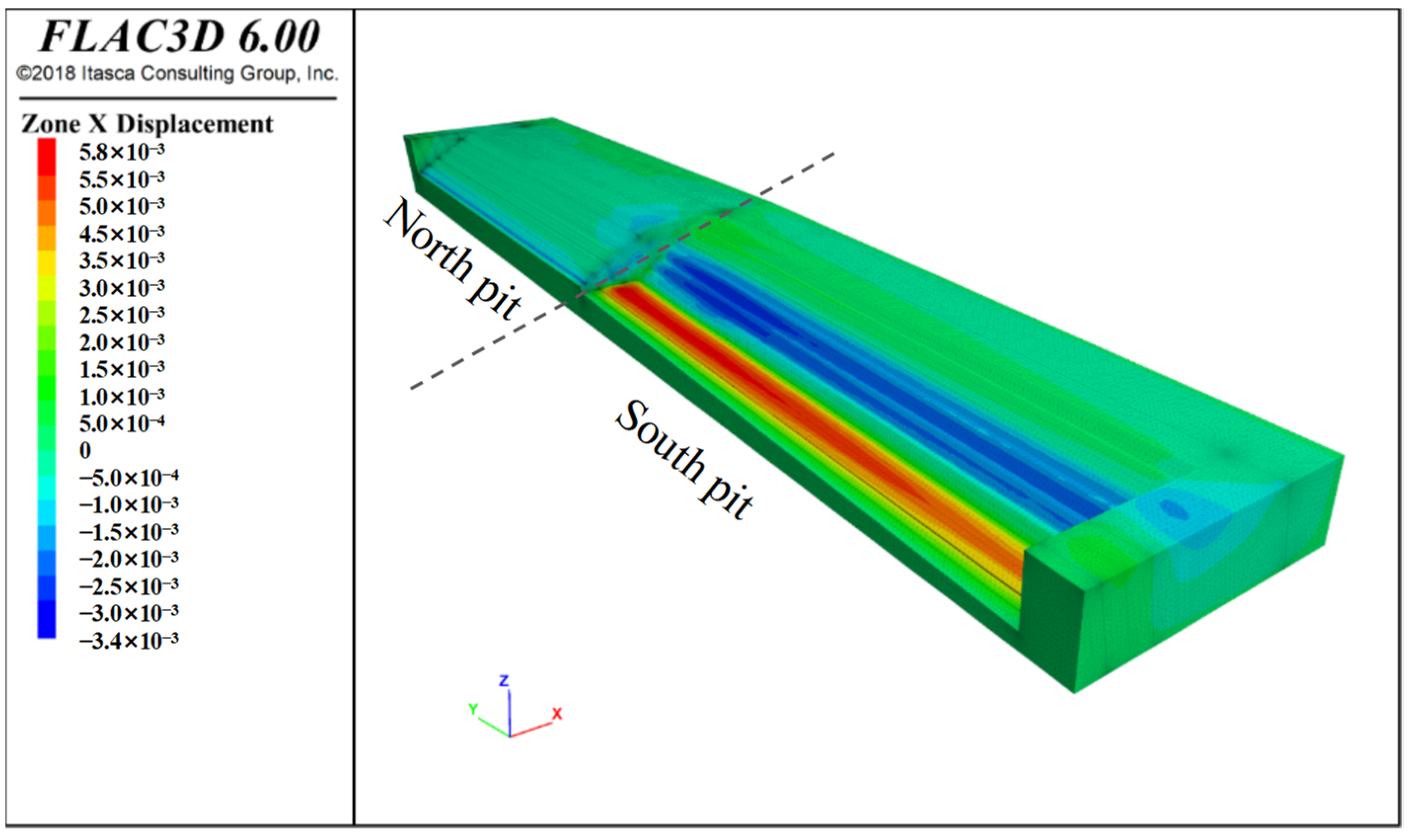
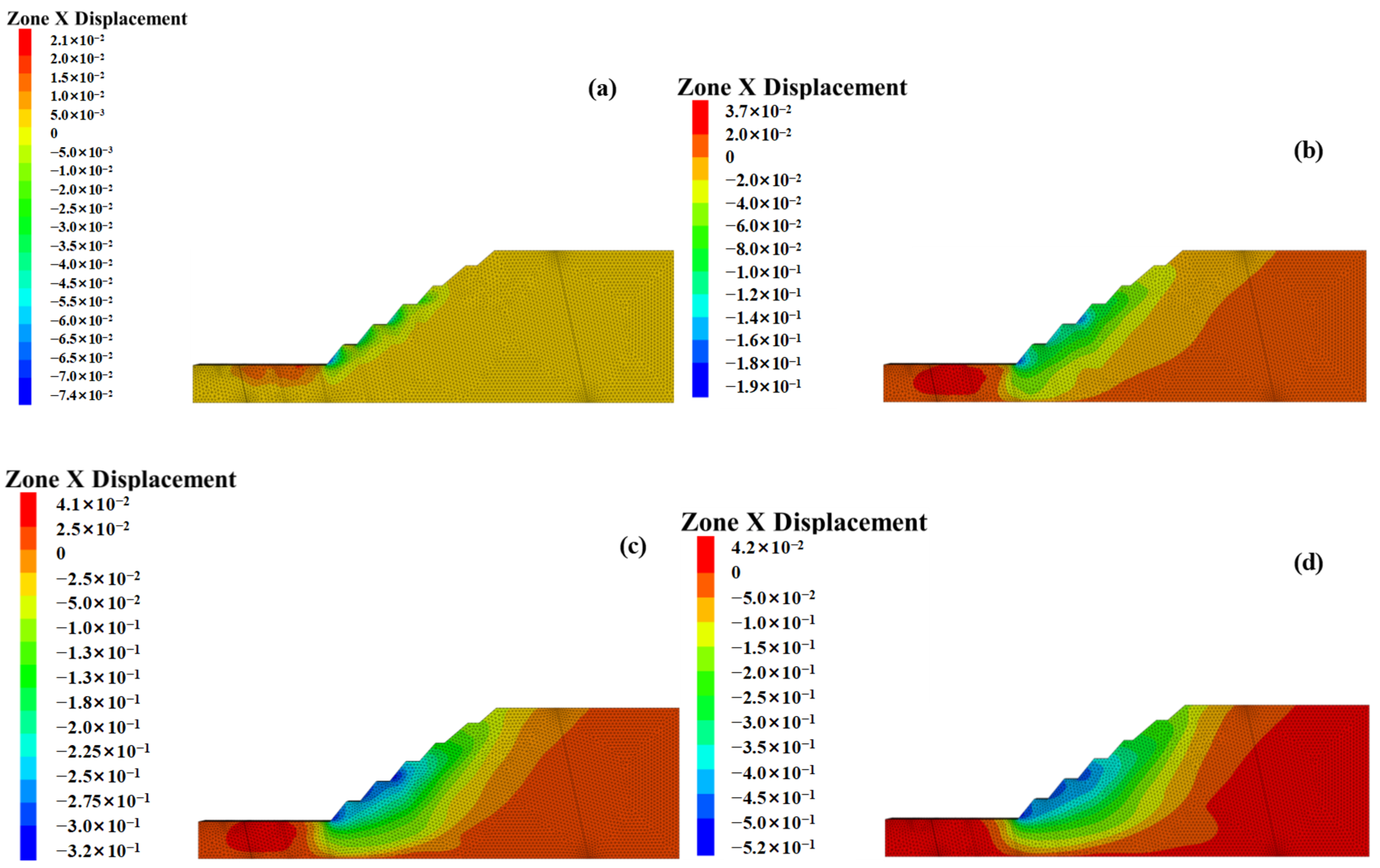
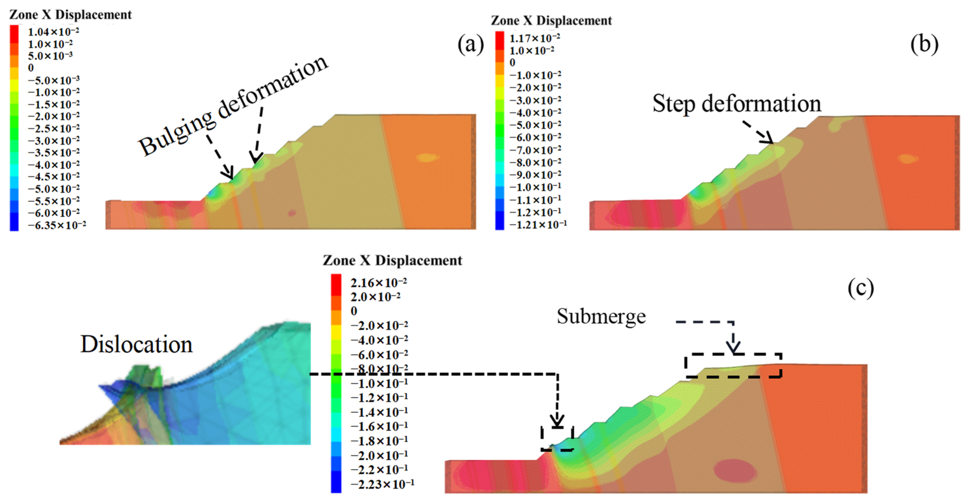
4.5.2. Displacement Analysis
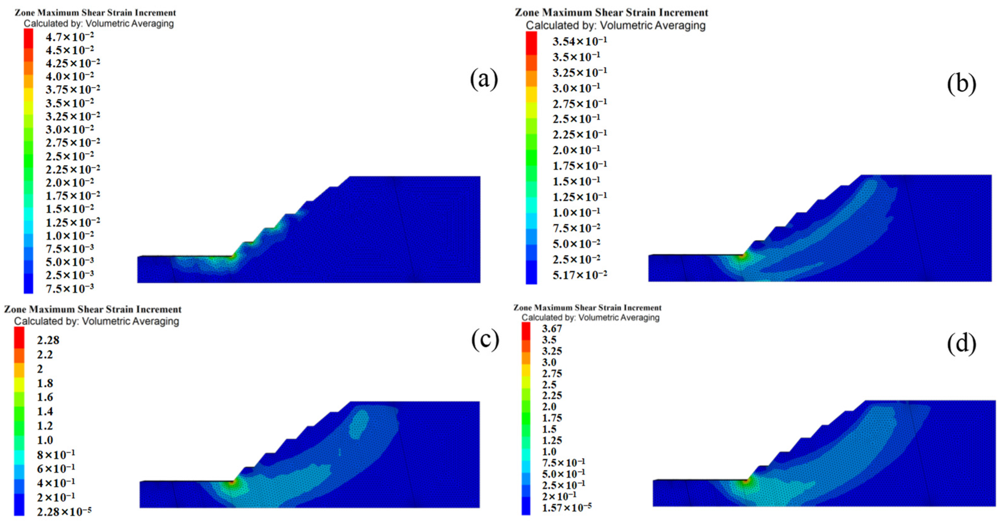
4.5.3. Shear Strain Distributions
4.5.4. Dynamic Deformation Characteristics
5. Discussion
5.1. Causes of Pit Slope Deformation and Failure
5.1.1. Topography and Geomorphology
5.1.2. Stratigraphic Lithological Distribution
5.1.3. Development Characteristics of Fractures
5.1.4. Geotechnical Properties of Rock Masses
5.1.5. Precipitation and Freeze–Thaw Cycles
5.1.6. Human Engineering Activities
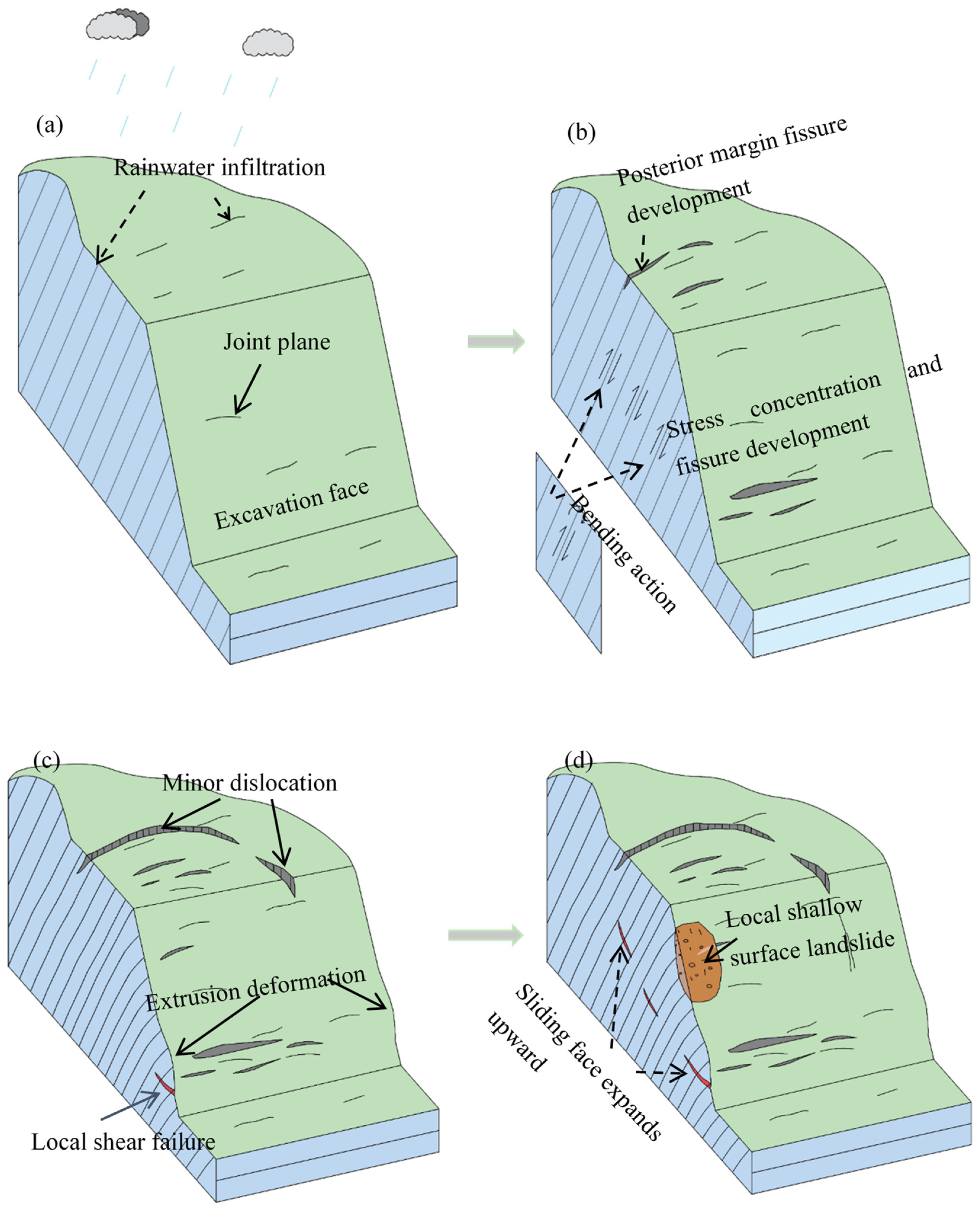
5.2. Deformation and Damage Pattern of the Pit Slope
- (1)
- The initial deformation stage
- (2)
- The development stage of lateral shear misalignment
- (3)
- The development stage of horizontal tensile-shear damage
- (4)
- The slip surface development to preslip stage
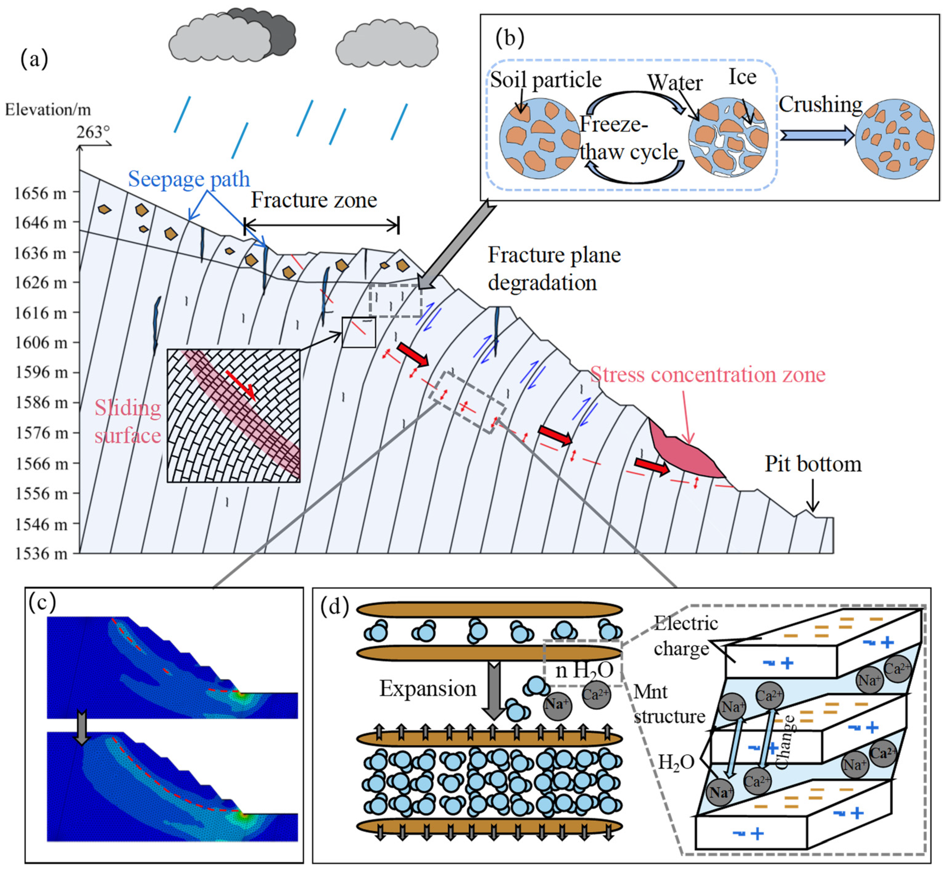
5.3. Evolution Mechanism of the Slope Deformation and Failure in the Wolong Coal Mine
5.4. Disaster Prevention and Control Recommendations
- (1)
- Management measures such as slope cutting and anchor support are taken to attenuate the effects of slope weight forces or to increase the structural stability of slopes.
- (2)
- Geotextile fabric can be placed on the slope surface to cope with the upcoming rainy season. At the same time, ditching works could be carried out in the eastern watercourse to reduce the impact of surface water on the slope.
- (3)
- During and after the disaster management process, GPS receivers and ground-based SAR need to be arranged on the slope surface and nearby areas, and specialists need to be arranged to monitor the dynamics of the landslide and to grasp the deformation and displacement characteristics of the slope. If large deformation is monitored, timely feedback should be given to experts for safety assessment.
6. Conclusions
- (1)
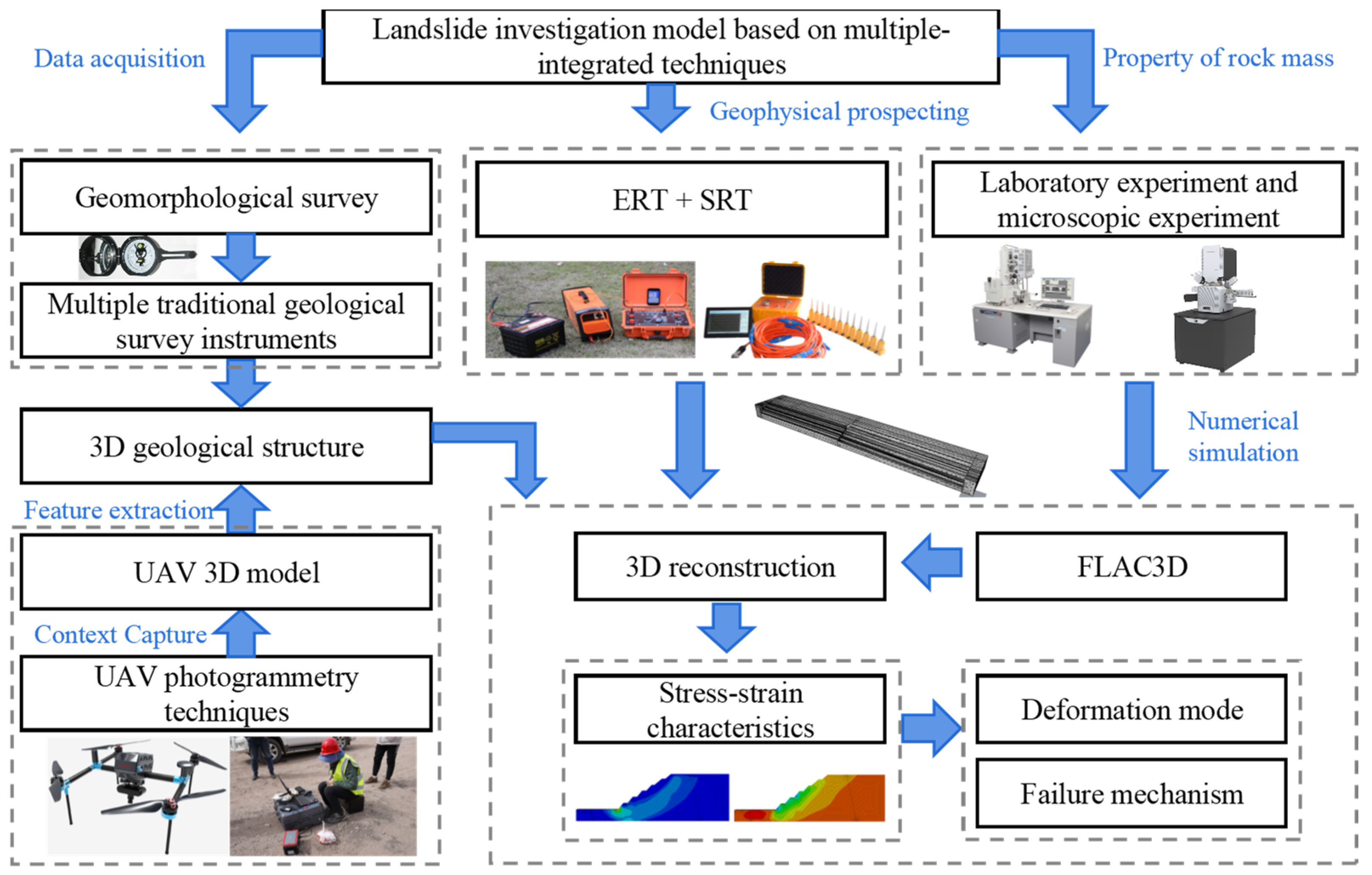
- This study establishes a landslide investigation framework based on the integration of multiple techniques, including field investigations, remote sensing analysis, experimental analysis, integrated physical exploration methods, and three-dimensional numerical simulations, for elucidating slope deformation patterns and damage mechanisms.
- (2)
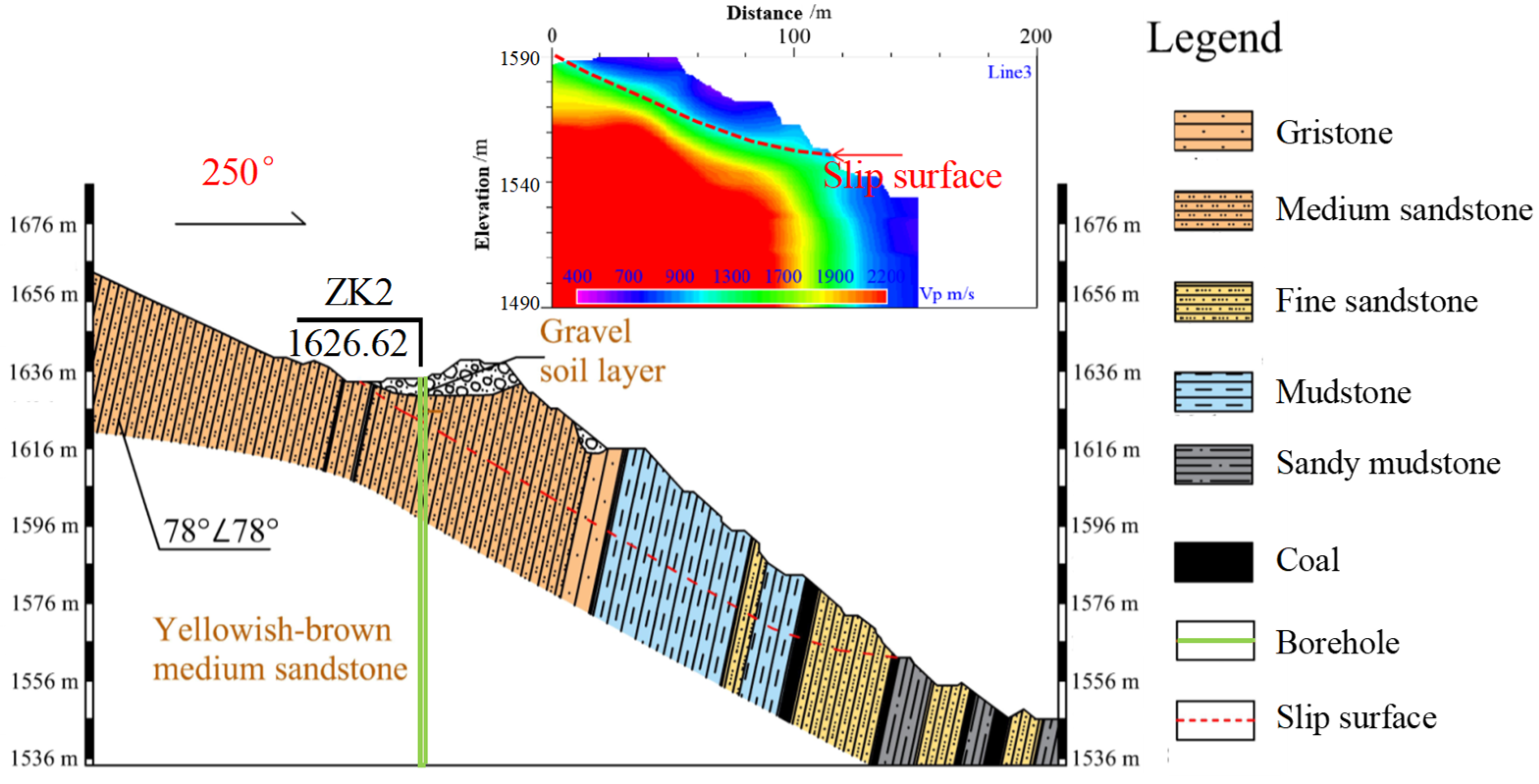
- In this study, a combination of field surveys, ERT surveys, and SRT analyses was employed to comprehensively determine the three-dimensional stratigraphic structure and characteristics of slip surfaces in the study area. The results indicate that the eastern pit slope is alternate layers of sandstone, mudstone, and sandy mudstone with an average stratigraphic dip angle of 78° ∠ 78°, which represents a typical soft-hard-interbedded anti-inclined layered rock slope. The potential slip surface is located at a deeper depth and is predominantly continuous, with a steeper upper part and a gentler lower section.
- (3)
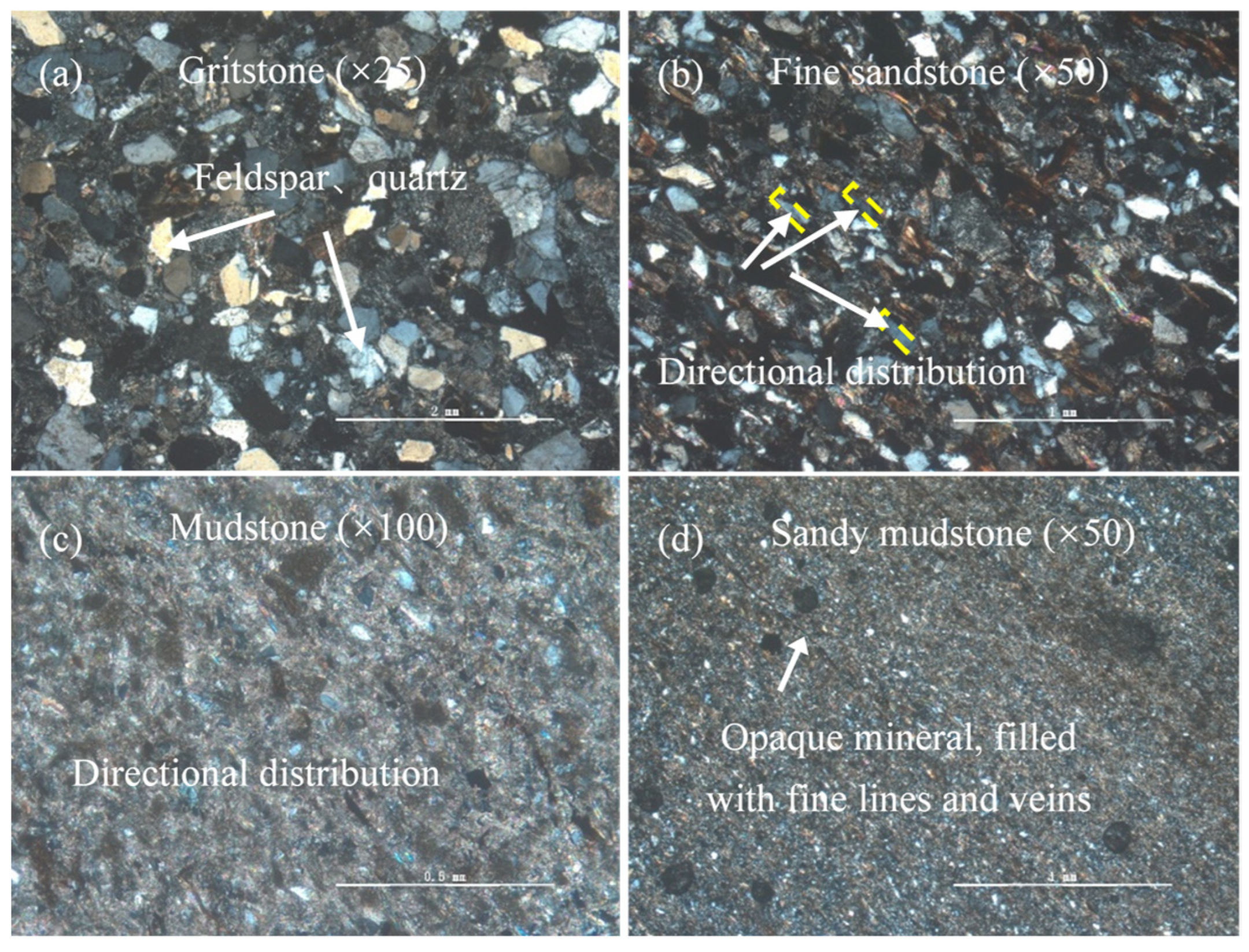
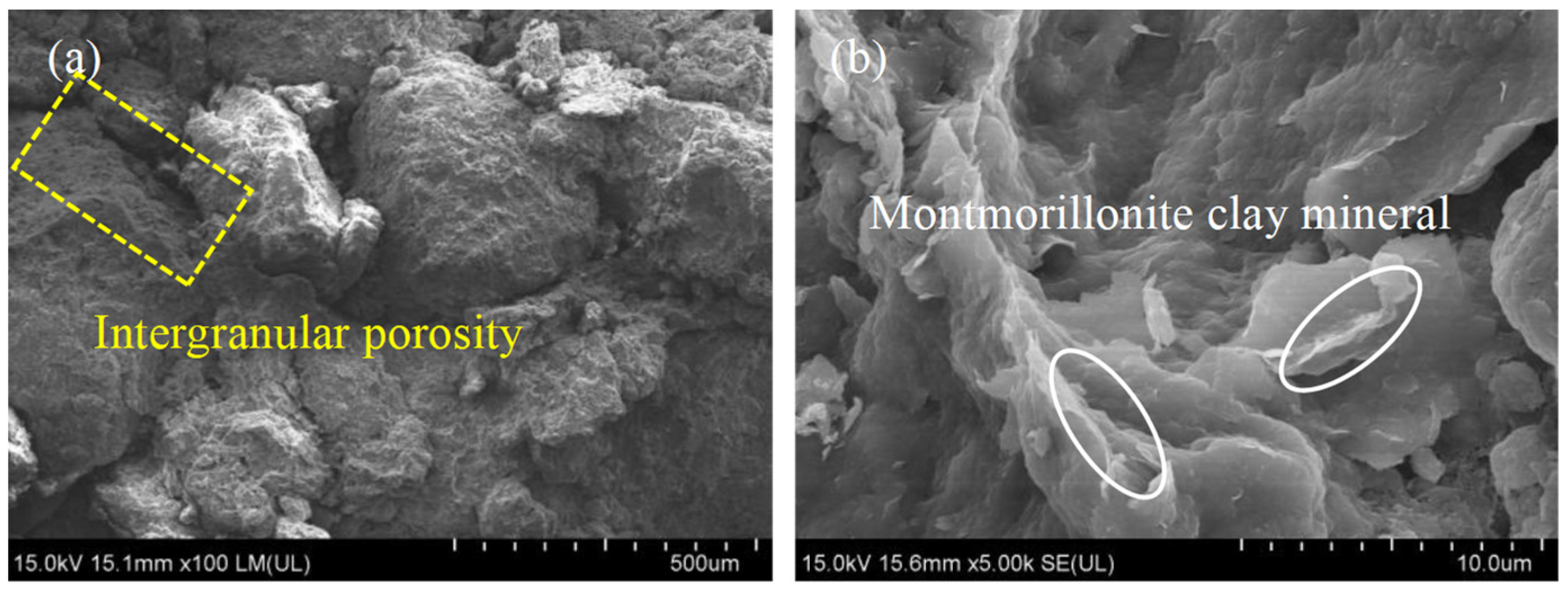
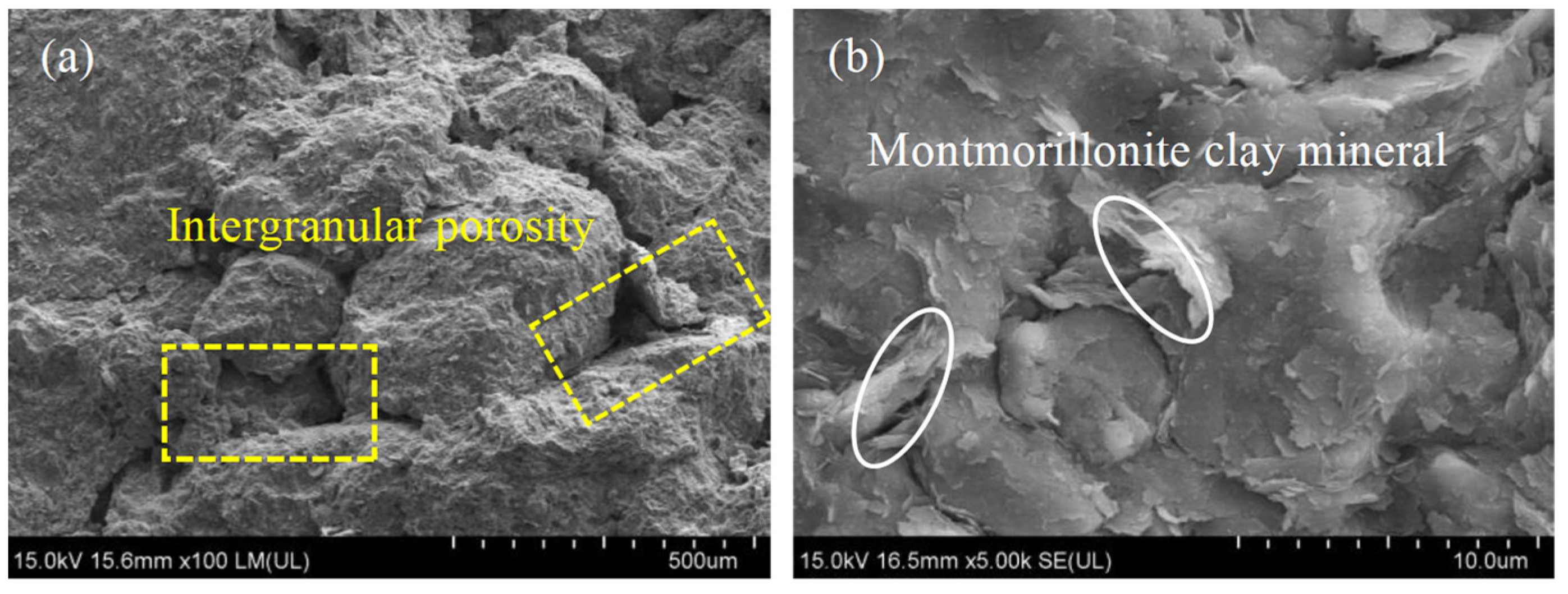
- A combination of standard geotechnical tests, rock thin section analyses, SEM and XRD analyses was employed to characterize the rock mass properties. The results show that the rock masses in the study area exhibit low strength, with clay mineral contents from 15.6% to 33.8% in sandstone and mudstone and 29.7% to 59.6% in mudstone and sandy mudstone. Since high contents of clay minerals make the rock mass hydrophilic and expansive, rock masses are susceptible to softening and damage when exposed to water.
- (4)
- The numerical simulation results of FLAC3D show that following the pit slope excavation, the potential slip surface continuously expanded and extended upward, while stress accumulation concentrated predominantly at the slope’s corners. The soft rock layers in the middle and lower sections of the slope initially underwent bulging deformation. With the aggravation of deformation, the upper rock layers also unloaded and deformed to the free surface, showing a typical flexural toppling failure pattern.
- (5)
- We highlight the significant role of stratigraphic structure and rock hydrophilicity and expansivity in controlling the deformation of the eastern pit slope in the Wolong Coal Mine. Surface water retention, freeze–thaw cycles, and human-driven engineering activities are the main triggers of pit slope destabilization. The deformation and failure process of the eastern pit slope can be categorized into four stages: the initial deformation stage, the development stage of lateral shear misalignment, the development stage of horizontal tensile-shear damage, and the slip surface development to the preslip stage. The research presented herein offers valuable insights and engineering implications for the study of soft-hard-interbedded anti-inclined layered rock slopes, both locally and globally.
Author Contributions
Funding
Institutional Review Board Statement
Informed Consent Statement
Data Availability Statement
Acknowledgments
Conflicts of Interest
References
- Brabb, E.E.; Harrod, B.L. Landslides: Extent and economic significance. Can. Geotech. J. 1990, 27, 408. [Google Scholar]
- Huang, R.Q.; Li, W.L. Formation, distribution and risk control of landslides in China. J. Rock Mech. Geotech. Eng. 2011, 3, 97–116. [Google Scholar] [CrossRef] [Scilit]
- Caine, N. Toppling failures from alpine cliffs on ben Lomond, Tasmania. Earth Surf. Process. Landf. 1982, 7, 133–152. [Google Scholar] [CrossRef] [Scilit]
- Cruden, D.; Hu, X.Q. Topples on underdip slopes in the Highwood Pass, Alberta, Canada. Q. J. Eng. Geol. Hydrogeol. 1994, 27, 57–68. [Google Scholar] [CrossRef] [Scilit]
- Tamrakar, N.K.; Yokota, S.; Osaka, O. A toppled structure with sliding in the Siwalik Hills, midwestern Nepal. Eng. Geol. 2002, 64, 339–350. [Google Scholar] [CrossRef] [Scilit]
- Tu, X.B.; Dai, F.C.; Lu, X.J.; Zhong, H.Y. Toppling and stabilization of the intake slope for the Fengtan Hydropower Station enlargement project, Mid-South China. Eng. Geol. 2007, 91, 152–167. [Google Scholar] [CrossRef] [Scilit]
- Goodman, R.E.; Bray, J.W. Toppling of rock slopes. In Proceedings of the Specialty Conference on Rock Engineering for Foundations and Slopes, Boulder, CO, USA, 15–18 August 1976. [Google Scholar]
- Adhikary, D.P.; Dyskin, A.V. Modelling of progressive and instantaneous failures of foliated rock slopes. Rock Mech. Rock Eng. 2007, 40, 349–362. [Google Scholar] [CrossRef] [Scilit]
- Wu, H.Q.; Pollard, D. An experimental study of the relationship between joint spacing and layer thickness. J. Struct. Geol. 1995, 17, 887–905. [Google Scholar] [CrossRef] [Scilit]
- Brideau, M.A.; Stead, D. Controls on block toppling using a three-dimensional distinct element approach. Rock Mech. Rock Eng. 2009, 43, 241–260. [Google Scholar] [CrossRef] [Scilit]
- Böhme, M.; Hermanns, R.L.; Oppikofer, T.; Fischer, L.; Bunkholt, H.S.S.; Eiken, T.; Pedrazzini, A.; Derron, M.-H.; Jaboyedoff, M.; Blikra, L.H.; et al. Analyzing complex rock slope deformation at Stampa, western Norway, by integrating geomorphology, kinematics and numerical modeling. Eng. Geol. 2013, 154, 116–130. [Google Scholar] [CrossRef] [Scilit]
- León Buendía, C.; Santamaría Arias, J.; Alejano, L.; Giráldez, R. Analysis of a complex slope failure in a quartzite slope. In Proceedings of the ISRM European Symposium, Vigo, Spain, 27–29 May 2014. [Google Scholar]
- Jiang, L.S.; Sainoki, A.; Mitri, H.S.; Ma, N.; Liu, H.T.; Hao, Z. Influence of fracture-induced weakening on coal mine gateroad stability. Int. J. Rock Mech. Min. 2016, 88, 307–317. [Google Scholar] [CrossRef] [Scilit]
- Zhan, J.W.; Wang, Q.; Zhang, W.; Shangguan, Y.L.; Song, S.Y.; Chen, J.P. Soil-engineering properties and failure mechanisms of shallow landslides in soft-rock materials. Catena 2019, 181, 104093. [Google Scholar] [CrossRef] [Scilit]
- Tao, Z.G.; Zhu, C.; He, M.C.; Liu, K.M. Research on the safe mining depth of anti-dip bedding slope in Changshanhao Mine. Geomech. Geophys. Geo-Energy Geo-Res. 2020, 6, 36. [Google Scholar]
- GB18306-2015; Seismic Ground Motion Parameters Zonation Map of China. General Administration of Quality Supervision, Inspection and Quarantine of the People’s Republic of China. Standards Press of China: Beijing, China, 2011.
- Cignetti, M.; Godone, D.; Wrzesniak, A.; Giordan, D. Structure from motion multisource application for landslide characterization and monitoring: The Champlas du Col Case study, Sestriere, North-Western Italy. Sensors 2019, 19, 2364. [Google Scholar] [CrossRef] [Scilit] [PubMed]
- Travelletti, J.; Delacourt, C.; Allemand, P.; Malet, J.P.; Schmittbuhl, J.; Toussaint, R.; Bastard, M. Correlation of multi-temporal ground-based optical images for landslide monitoring: Application, potential and limitations. ISPRS J. Photogramm. 2012, 70, 39–55. [Google Scholar] [CrossRef] [Scilit]
- Guzzetti, F.; Reichenbach, P.; Cardinali, M.; Galli, M.; Ardizzone, F. Probabilistic landslide hazard assessment at the basin scale. Geomorphology 2005, 72, 272–299. [Google Scholar] [CrossRef] [Scilit]
- Chacón, J.; Irigaray, C.; Fernández, T.; El Hamdouni, R. Engineering geology maps: Landslides and geographical information systems. Bull. Eng. Geol. Environ. 2006, 65, 341–411. [Google Scholar] [CrossRef] [Scilit]
- Zhan, J.W.; Yu, Z.Y.; Lv, Y.; Peng, J.B.; Song, S.Y.; Yao, Z.W. Rockfall hazard assessment in the Taihang Grand Canyon scenic area integrating regional-scale identification of potential rockfall sources. Remote Sens. 2022, 14, 3021. [Google Scholar] [CrossRef] [Scilit]
- Chen, W.J.; Liu, H.T.; Liu, J.M.; Sun, X.G.; Zeng, Q.D. Integrated geophysical exploration for the Longtoushan Ag-Pb-Zn deposit in the southeast of the Da Xing’an Ling mountains, Inner Mongolia, northern China. Explor. Geophys. 2010, 41, 279–288. [Google Scholar] [CrossRef] [Scilit]
- Uhlemann, S.; Wilkinson, P.B.; Maurer, H.; Wagner, F.M.; Johnson, T.C.; Chambers, J.E. Optimized survey design for electrical resistivity tomography: Combined optimization of measurement configuration and electrode placement. Geophys. J. Int. 2018, 214, 108–121. [Google Scholar] [CrossRef] [Scilit]
- Yannah, M.; Martens, K.; Van Camp, M.; Walraevens, K. Geophysical exploration of an old dumpsite in the perspective of enhanced landfill mining in Kermt area, Belgium. Bull. Eng. Geol. Environ. 2019, 78, 55–67. [Google Scholar] [CrossRef] [Scilit]
- Uhlemann, S.; Hagedorn, S.; Dashwood, B.; Maurer, H.; Gunn, D.; Dijkstra, T.; Chambers, J. Landslide characterization using P- and S-wave seismic refraction tomography-the importance of elastic moduli. J. Appl. Geophys. 2016, 134, 64–76. [Google Scholar] [CrossRef] [Scilit]
- Imani, P.; Tian, G.; Hadiloo, S.; El-Raouf, A.A. Application of combined electrical resistivity tomography (ERT) and seismic refraction tomography (SRT) methods to investigate Xiaoshan District landslide site: Hangzhou, China. J. Appl. Geophys. 2021, 184, 104236. [Google Scholar] [CrossRef] [Scilit]
- GB/T 50123-2019; Standard for Geotechnical Test Methods. Ministry of Housing and Urban-Rural Development of the People’s Republic of China and Standardization Administration of the People’s Republic of China. China Planning Press: Beijing, China, 2019.
- Schäbitz, M.; Janssen, C.; Wenk, H.R.; Wirth, R.; Schuck, B.; Wetzel, H.U.; Meng, X.; Dresen, G. Microstructures in landslides in northwest China-implications for creeping displacements? J. Struct. Geol. 2018, 106, 70–85. [Google Scholar] [CrossRef] [Scilit]
- GB/T 50266-2013; Standard for Test Methods of Engineering Rock Mass. Ministry of Housing and Urban-Rural Development of the People’s Republic of China. China Planning Press: Beijing, China, 2013.
- Weidinger, J.T.; Schramm, J.-M.; Nuschej, F. Ore mineralization causing slope failure in a high-altitude mountain crest—On the collapse of an 8000 m peak in Nepal. J. Asian Earth Sci. 2002, 21, 295–306. [Google Scholar] [CrossRef] [Scilit]
- Wang, G.; Suemine, A.; Schulz, W. Shear-rate-dependent strength control on the dynamics of rainfall-triggered landslides, Tokushima Prefecture, Japan. Earth Surf. Proc. Landf. 2010, 35, 407–416. [Google Scholar] [CrossRef] [Scilit]
- Zhan, J.W.; Eberhardt, E.; Han, X.D.; Pang, Y.M.; Chen, J.P. Robust estimation of fracture trace length distributions derived from underground mapping and long narrow sampling windows. Tunn. Undergr. Space Technol. 2022, 128, 104630. [Google Scholar] [CrossRef] [Scilit]
- Mauldon, M. Estimating mean fracture trace length and density from observations in convex windows. Rock Mech. Rock Eng. 1998, 31, 201–216. [Google Scholar] [CrossRef] [Scilit]
- Song, J.J.; Lee, C.I. Estimation of joint length distribution using window sampling. Int. J. Rock Mech. Min. 2001, 38, 519–528. [Google Scholar] [CrossRef] [Scilit]
- Zhan, J.W.; Chen, J.P.; Xu, P.H.; Zhang, W.; Han, X.D.; Zhou, X. Automatic identification of rock fracture sets using finite mixture models. Math. Geosci. 2017, 49, 1021–1056. [Google Scholar] [CrossRef] [Scilit]
- Hoek, E.; Brown, E.T. The Hoek–Brown failure criterion and GSI—2018 edition. J. Rock Mech. Geotech. 2019, 11, 445–463. [Google Scholar] [CrossRef] [Scilit]
- Sonmez, H.; Ulusay, R. Modifications to the geological strength index (GSI) and their applicability to stability of slopes. Int. J. Rock Mech. Min. 1999, 36, 743–760. [Google Scholar] [CrossRef] [Scilit]
- Palmstrom, A. Measurements of and correlations between block size and rock quality designation (RQD). Tunn. Undergr. Space Technol. 2005, 20, 362–377. [Google Scholar] [CrossRef] [Scilit]
- Hoek, E.; Carranza-Torres, C.; Corkum, B.; Hoek, E.; Carranza-Torres, C. Hoek-Brown failure criterion-2002 Edition. In Proceedings of the 5th North American Rock Mechanics Symposium, Toronto, ON, Canada, 7–10 July 2002. [Google Scholar]
- Hoek, E.; Brown, E.T. Practical estimates of rock mass strength. Int. J. Rock Mech. Min. 1997, 34, 1165–1186. [Google Scholar] [CrossRef]
- Longoni, L.; Papini, M.; Arosio, D.; Zanzi, L.; Brambilla, D. A new geological model for Spriana landslide. Bull. Eng. Geol. Environ. 2014, 73, 959–970. [Google Scholar] [CrossRef] [Scilit]
- Wang, Z.Y.; Zhang, W.G.; Gao, X.C.; Liu, H.; Böhlke, T. Stability analysis of soil slopes based on strain information. Acta Geotech. 2020, 15, 3121–3134. [Google Scholar] [CrossRef] [Scilit]
- Tu, J.Z.; Zhang, Y.L.; Mei, G.; Xu, N.X. Numerical investigation of progressive slope failure induced by sublevel caving mining using the finite difference method and adaptive local remeshing. Appl. Sci. 2021, 11, 3812. [Google Scholar] [CrossRef] [Scilit]
- Yu, J.L.; Zhao, J.J.; Yan, H.Y.; Lai, Q.Y.; Huang, R.Q.; Liu, X.W.; Li, Y.C. Deformation and failure of a high-steep slope induced by multi-layer coal mining. J. Mt. Sci.-Engl. 2020, 17, 2942–2960. [Google Scholar] [CrossRef] [Scilit]
- Li, S.L.; Qiu, C.; Huang, J.K.; Guo, X.P.; Hu, Y.C.; Mugahed, A.-S.Q.; Tan, J. Stability analysis of a high-steep dump slope under different rainfall conditions. Sustainability 2022, 14, 11148. [Google Scholar] [CrossRef] [Scilit]
- Rong, P.; Zuo, Y.J.; Lin, J.Y.; Chen, Q.G.; Zheng, L.L.; Jin, K.Y. Study of mechanical properties and failure characteristics of combined rock mass with weak interlayer. Geomech. Geophys. Geo-Energy Geo-Res. 2022, 8, 89. [Google Scholar] [CrossRef] [Scilit]
- Lu, J.K.; Xu, T.; Tang, X.H.; Heap, M.J.; Xu, J.J.; Yang, T.H.; Zhao, X. Nanoindentation-based characterization of micromechanical properties of greenish mudstone from deep Fushun West open-pit mine (Fushun city, China). Geomech. Geophys. Geo-Energy Geo-Res. 2022, 8, 59. [Google Scholar] [CrossRef] [Scilit]
- Mateos, R.M.; García-Moreno, I.; Azañón, J.M. Freeze–thaw cycles and rainfall as triggering factors of mass movements in a warm Mediterranean region: The case of the Tramuntana Range (Majorca, Spain). Landslides 2012, 9, 417–432. [Google Scholar] [CrossRef] [Scilit]






| Category | Number of Steps | Pit Floor Elevation/m | Pit Top Elevation/m | Relative Elevation/m | Terrain Slope/° |
|---|---|---|---|---|---|
| North pit | 6 | 1580 | 1637 | 57 | 32 |
| South pit | 8 | 1545 | 1628 | 83 | 33 |
| Landslide | Length/m | Width/m | Relative Height Difference/m | Terrain Slope/° | Sliding Direction/° | Area/m2 |
|---|---|---|---|---|---|---|
| I-1 | 45 | 48 | 26 | 30 | 255 | 0.20 × 10⁴ |
| I-2 | 107 | 117 | 43 | 28 | 237 | 1.12 × 10⁴ |
| I-3 | 35 | 58 | 17 | 31 | 219 | 0.16 × 10⁴ |
| I-4 | 129 | 143 | 59 | 28 | 262 | 1.71 × 10⁴ |
| I-5 | 116 | 135 | 49 | 26 | 263 | 1.47 × 10⁴ |
| Sample | Qtz | Kfs | Ab | Ank | Cal | Clay | Relative Content of Clay Mineral Species | |||
|---|---|---|---|---|---|---|---|---|---|---|
| Montmorillonite | Illite | Kaolinite | Chlorite | |||||||
| % | % | % | % | % | % | % | % | % | % | |
| Gritstone 1 | 42.4 | 14.6 | 24.7 | 1.7 | 1.0 | 15.6 | 19.3 | 2.0 | 59.9 | 18.8 |
| Gritstone 2 | 49.1 | 14.1 | 12.0 | 2.1 | 0.0 | 22.7 | 92.4 | 1.2 | 4.1 | 2.3 |
| Gritstone 3 | 43.5 | 16.5 | 9.3 | 0.7 | 0.0 | 30.1 | 81.8 | 2.4 | 12.3 | 3.4 |
| Fine sandstone 1 | 23.8 | 23.3 | 15.6 | 1.3 | 29.0 | 6.9 | 6.4 | 1.6 | 44.3 | 47.6 |
| Fine sandstone 2 | 48.1 | 6.5 | 6.1 | 1.1 | 1.9 | 36.3 | 68.4 | 4.8 | 19.3 | 7.5 |
| Fine sandstone 3 | 39.0 | 6.8 | 5.6 | 1.2 | 10.7 | 33.8 | 68.9 | 8.7 | 13.1 | 9.3 |
| Sandy mudstone 1 | 38.2 | 5.2 | 7.5 | 0.0 | 0.0 | 49.1 | 66.6 | 6.0 | 18.3 | 9.1 |
| Sandy mudstone 2 | 11.5 | 1.8 | 2.9 | 0.0 | 44.1 | 29.7 | 9.3 | 22.7 | 48.8 | 19.2 |
| Sandy mudstone 3 | 35.7 | 5.5 | 7.1 | 0.0 | 0.0 | 50.9 | 10.3 | 12.6 | 56.4 | 20.6 |
| Mudstone 1 | 37.5 | 1.6 | 4.8 | 0.0 | 0.0 | 54.9 | 44.1 | 15.7 | 24.2 | 16.0 |
| Mudstone 2 | 34.1 | 3.4 | 2.9 | 0.0 | 0.0 | 59.6 | 43.5 | 13.2 | 25.7 | 17.6 |
| Mudstone 3 | 39.5 | 8.9 | 6.7 | 0.0 | 0.0 | 44.9 | 71.8 | 6.7 | 13.1 | 8.4 |
| Lithology | Particle Density | Unit Weight (g/cm3) | Uniaxial Compressive Strength (MPa) | Deformation Index | Shear Strength | Tensile Strength | ||||
|---|---|---|---|---|---|---|---|---|---|---|
| Natural State | Dry State | Elastic Modulus | Poisson’s Ratio | Cohesion | Internal Friction Angle | Natural State | ||||
| Single Value | Mean Value | E/GPa | v | C/MPa | φ/° | Single Value | Mean Value | |||
| Gritstone | 2.66 | 2.32 | 5.04 | 8.25 | 0.101–0.127 | 0.37 | 0.229 | 43.2 | 0.068 | 0.152 |
| 7.52 | 0.147 | |||||||||
| 12.2 | 0.241 | |||||||||
| 2.65 | 2.2 | 4.65 | 6.09 | 0.072–0.108 | 0.38 | 0.111 | 43.8 | 0.051 | 0.081 | |
| 5.91 | 0.062 | |||||||||
| 7.7 | 0.130 | |||||||||
| Medium sandstone | 2.65 | 2.2 | 13.4 | 17.7 | 4.49–7.54 | 0.27 | 0.473 | 43.5 | 0.173 | 0.241 |
| 19.5 | 0.186 | |||||||||
| 20.1 | 0.364 | |||||||||
| 2.66 | 2.23 | 23.8 | 30 | 0.156–0.2 | 0.36 | 1.23 | 43.9 | 0.146 | 0.24 | |
| 27.2 | 0.257 | |||||||||
| 39.1 | 0.316 | |||||||||
| Fine sandstone | 2.74 | 2.43 | 9.69 | 11 | 1.49–2.46 | 0.28 | 0.797 | 41.7 | 0.260 | 0.334 |
| 11.1 | 0.281 | |||||||||
| 12.3 | 0.460 | |||||||||
| 2.71 | 2.41 | 15 | 16.6 | 1.12–2.10 | 0.29 | 0.982 | 40.7 | 0.063 | 0.088 | |
| 15.8 | 0.069 | |||||||||
| 19.1 | 0.132 | |||||||||
| Mudstone | 2.71 | 2.32 | 9.23 | 10.7 | 0.225–0.462 | 0.3 | 0.528 | 46.7 | 0.060 | 0.223 |
| 10.5 | 0.242 | |||||||||
| 12.4 | 0.368 | |||||||||
| 2.73 | 2.32 | 6.21 | 8.72 | 0.444–0.836 | 0.31 | 0.445 | 40.8 | 0.188 | 0.26 | |
| 8.15 | 0.222 | |||||||||
| 11.8 | 0.371 | |||||||||
| Sandy mudstone | 2.72 | 2.36 | 16.7 | 20.1 | 0.126–0.156 | 0.35 | 2.65 | 43.8 | 0.243 | 1.58 |
| 18.9 | 2.14 | |||||||||
| 24.8 | 2.36 | |||||||||
| 2.73 | 2.4 | 15.1 | 19.8 | 0.030–0.069 | 0.38 | 0.879 | 41.2 | 0.096 | 0.28 | |
| 18 | 0.282 | |||||||||
| 26.4 | 0.461 | |||||||||
| Lithology | Fracture Set | Orientation | Number of Fractures | Average Spacing/cm | Jv |
|---|---|---|---|---|---|
| Gritstone | 1 | 96° ∠ 73° | 57 | 8.65 | 17.70 |
| 2 | 76° ∠ 51° | 28 | 28.5 | ||
| 3 | 100° ∠ 53° | 9 | 38.05 | ||
| Medium sandstone | 1 | 65° ∠ 68° | 90 | 7.23 | 21.27 |
| 2 | 343° ∠ 38° | 37 | 13.43 | ||
| Fine sandstone | 1 | 74° ∠ 65° | 182 | 11.17 | 11.25 |
| 2 | 288° ∠ 37° | 11 | 43.55 | ||
| Mudstone | 1 | 80° ∠ 78° | 98 | 41.66 | 9.30 |
| 2 | 185° ∠ 83° | 62 | 23.44 | ||
| 3 | 283° ∠ 69° | 45 | 37.88 | ||
| Sandy mudstone | 1 | 68° ∠ 81° | 21 | 0.23 | 5.13 |
| 2 | 308° ∠ 23° | 12 | 22.51 | ||
| 3 | 227° ∠ 43° | 14 | 27.13 |
| Lithology | GSI | D | s | a | ||
|---|---|---|---|---|---|---|
| Gritstone | 32.1 | 15 | 0.33 | 0.822 | 0.0002 | 0.519 |
| Medium sandstone | 29.9 | 14 | 0.42 | 0.589 | 0.0001 | 0.522 |
| Fine sandstone | 30.2 | 12 | 0.18 | 0.834 | 0.0003 | 0.522 |
| Mudstone | 26.9 | 8 | 0.13 | 0.490 | 0.0002 | 0.528 |
| Sandy mudstone | 20.8 | 10 | 0.03 | 0.566 | 0.0001 | 0.541 |
| Lithology | Weight | Cohesion | Internal Friction Angle | Deformation Modulus |
|---|---|---|---|---|
| Cm/MPa | φm/° | Em/MPa | ||
| Gritstone | 24.4 | 0.270 | 24.65 | 822.01 |
| Medium sandstone | 23.6 | 0.598 | 22.01 | 1093.18 |
| Fine sandstone | 20.5 | 0.559 | 24.74 | 1188.89 |
| Mudstone | 21.8 | 0.367 | 20.56 | 891.83 |
| Sandy mudstone | 18 | 0.447 | 21.41 | 735.04 |
Disclaimer/Publisher’s Note: The statements, opinions and data contained in all publications are solely those of the individual author(s) and contributor(s) and not of MDPI and/or the editor(s). MDPI and/or the editor(s) disclaim responsibility for any injury to people or property resulting from any ideas, methods, instructions or products referred to in the content. |
© 2024 by the authors. Licensee MDPI, Basel, Switzerland. This article is an open access article distributed under the terms and conditions of the Creative Commons Attribution (CC BY) license (https://creativecommons.org/licenses/by/4.0/).
Share and Cite
Chen, G.; Cai, P.; Zhan, J.; Yang, Y.; Yao, Z.; Yu, Z. Deformation Patterns and Failure Mechanisms of Soft-Hard-Interbedded Anti-Inclined Layered Rock Slope in Wolong Open-Pit Coal Mine. Appl. Sci. 2024, 14, 3082. https://doi.org/10.3390/app14073082
Chen G, Cai P, Zhan J, Yang Y, Yao Z, Yu Z. Deformation Patterns and Failure Mechanisms of Soft-Hard-Interbedded Anti-Inclined Layered Rock Slope in Wolong Open-Pit Coal Mine. Applied Sciences. 2024; 14(7):3082. https://doi.org/10.3390/app14073082
Chicago/Turabian StyleChen, Guohong, Peng Cai, Jiewei Zhan, Yueqiao Yang, Zhaowei Yao, and Zhaoyue Yu. 2024. "Deformation Patterns and Failure Mechanisms of Soft-Hard-Interbedded Anti-Inclined Layered Rock Slope in Wolong Open-Pit Coal Mine" Applied Sciences 14, no. 7: 3082. https://doi.org/10.3390/app14073082
APA StyleChen, G., Cai, P., Zhan, J., Yang, Y., Yao, Z., & Yu, Z. (2024). Deformation Patterns and Failure Mechanisms of Soft-Hard-Interbedded Anti-Inclined Layered Rock Slope in Wolong Open-Pit Coal Mine. Applied Sciences, 14(7), 3082. https://doi.org/10.3390/app14073082