Systematic Review

Evaluating the Current Situation of River and Lake Shoreline Planning and Utilization Using an Improved Matter-Element Extension Model

1
School of Water Conservancy, North China University of Water Resources and Electric Power, Zhengzhou 450046, China
2
Collaborative Innovation Center of Water Resources Efficient Utilization and Support Engineering, Henan Province, Zhengzhou 450046, China
3
Henan Key Laboratory of Water Environment Simulation and Treatment, Zhengzhou 450046, China
4
Transportation Bureau of Lincang, Lincang 677000, China
*
Author to whom correspondence should be addressed.
Appl. Sci. 2024, 14(21), 9857; https://doi.org/10.3390/app14219857
Submission received: 2 August 2024 / Revised: 16 October 2024 / Accepted: 17 October 2024 / Published: 28 October 2024
(This article belongs to the Section Ecology Science and Engineering)

Abstract

:
Based on the analysis of the influencing factors of the current planning and utilization of river and lake shorelines, an index system of the current planning and utilization of river and lake shorelines is constructed. Based on the triangular fuzzy number method and the improved CRITIC method, the evaluation indicators are weighted and analyzed and then integrated to obtain the combined weight. An improved matter-element extension model was constructed to evaluate the current situation of shoreline planning and utilization in typical regions. At the same time, the TOPSIS evaluation model and the cloud theory evaluation model were compared and analyzed to verify the accuracy of the model. The improved matter-element model accounts for indicator incompatibility and the uncertainty of evaluation boundaries, offering a clearer reflection of the planning and utilization status.

1. Introduction

River and lake shorelines are non-renewable resources vital to regional economic development. Knowing the current situation of shorelines in advance can lay a solid foundation for shoreline management, find out the problems existing in shoreline management, and take timely measures to ensure the sustainable development of shorelines. The protection and management of river and lake shorelines is one of the key tasks of the river director system. In order to strengthen the quality of supervision over the planning and utilization of river and lake shorelines, it is necessary to make a comprehensive evaluation of the current situation of shoreline planning and utilization. Chu Van Cuonget et al. [1] developed prioritized strategic actions for erosion management and sustainable development in various sections of the coastline based on an integrated cross-sectoral approach and practical experience of conservation and development in the Kien Giang Biosphere Reserve project. David Griffiths et al. [2] developed a model of the management process based on the application of transects and area-based assessments, which enabled the development of management strategies. Zhang Xibing et al. [3] analyzed the impact of the Three Gorges Project operating environment on the utilization of the shoreline in the middle and lower reaches of the Yangtze River and pointed out the current principles that should be followed in the protection and utilization of the shoreline: protection is the main focus, ecological construction is the first priority, rational layout, moderate development and utilization, resource conservation, and standardized management; in the aspects of planning, management, scientific research, and environmental remediation, they also put forward the strategy to further improve the system of the protection and utilization of the shoreline Initiatives.
At present, many scholars have carried out relevant research on shoreline evaluation. Wang Chuansheng et al. [4] evaluated and analyzed the shoreline in the middle and lower reaches of the Yangtze River, and the results showed that the important factors affecting the quality of the shoreline were the water depth in front of the bank and the stability of the shoreline. Yang Yinkai and others [5] selected factors such as water volume requirements, protection requirements, land area requirements, siltation requirements, regional requirements, collection and distribution requirements, and the scale of urban construction used to evaluate the resources of offshore port sites in Liaoning Province. Cao Weidong et al. [6] used the GIS platform to find out the current situation of the utilization of shoreline resources, made clear the spatial division and functional definition of shoreline resources at all levels, and gave the overall functional positioning and spatial layout of the planning of the riverside port of Guohu, as well as the specific measures and opinions on the development of shoreline and port. Duan Xuejun et al. [7] summarized the development process of the spatial heterogeneity of the development function of the coastline of the Yangtze River Basin from the perspective of historical development according to the basic concept of developing the spatial function of the coastline of the Yangtze River Basin, summarized the theoretical basis for the positioning of the functional responsibilities of the spatial development and utilization of the coastline, and analyzed the locational function of the spatial development of the coastline of the Yangtze River Basin. Tian Hailan et al. [8] analyzed and studied the changing characteristics of shoreline and island dynamics in the Caofeidian region from the natural geographic perspective based on the interpretation of remote sensing image maps of the Caofeidian region in 10 periods.
The traditional comprehensive evaluation methods mainly include the analytic hierarchy process [9,10], Bayesian network method [11,12,13,14,15], fuzzy comprehensive evaluation method [16,17,18], Vague set method [19], grey relational degree method [20], cloud model method [21], etc. The matter-element extension model is a method to determine the classical domain matter-element, nodal domain matter-element, and matter-element to be evaluated and the correlation function through the matter-element theory, make qualitative analysis by using the extension of matter-element, and make quantitative calculation by using the correlation function, and finally obtain the evaluation result. At present, the matter-element theory has achieved considerable results [22,23]. Yu Weijiang et al. [24] carried out a water quality evaluation based on the improved matter-element extension evaluation model and compared the results with the comprehensive scoring method and the attribute identification method, which proves the rationality of improving the matter-element model. Wang Runying et al. [25] used the matter-element model to evaluate the comprehensive benefits of watershed governance and pointed out that when the evaluation index value fluctuated slightly, the model was still stable and reliable and had good practicability. Yi Xiangbin et al. [26] established a matter-element model based on the life cycle assessment method and sorted the process flow through the calculation of the correlation degree.
In this paper, the triangular fuzzy number method [27] and the improved CRITIC method are used to calculate the index weights, and an improved matter-element extension evaluation model is constructed by combining the matter-element theory and extension sets, and the comparison and analysis are made with the TOPSIS model and the cloud theory model. Zhang Lei et al. [28] analyzed the sensitivity factors from the hydrological conditions of the basin, regional water supply and demand, and economic and social development, selected the influencing factors to construct the index system and used the material element topology model to allocate the water rights of the industry and the region of the reservoir in accordance with the water supply of the reservoir.
The improved material element extension model was chosen because it can effectively solve the incompatibility between evaluation indicators, improve the accuracy of the evaluation results, consider the uncertainty and ambiguity of the data, and provide good flexibility and adaptability to different evaluation scenarios. In addition, the model is based on a combination of subjective and objective weighting methods, which improves the scientific and rational nature of the evaluation. It can also provide decision support and has been validated in empirical studies in several fields, proving its effectiveness and feasibility in solving complex system evaluation problems.
However, the planning and utilization of river and lake shorelines face many challenges, including low resource utilization, high pressure on ecological protection, frequent problems of illegal construction, and difficulties in curbing illegal sand mining activities. In addition, existing planning and management measures are deficient and lack effective regulation and enforcement. Lack of data limits the development of scientific decision-making, while existing evaluation methods may not fully capture the complexity of shoreline planning and utilization.

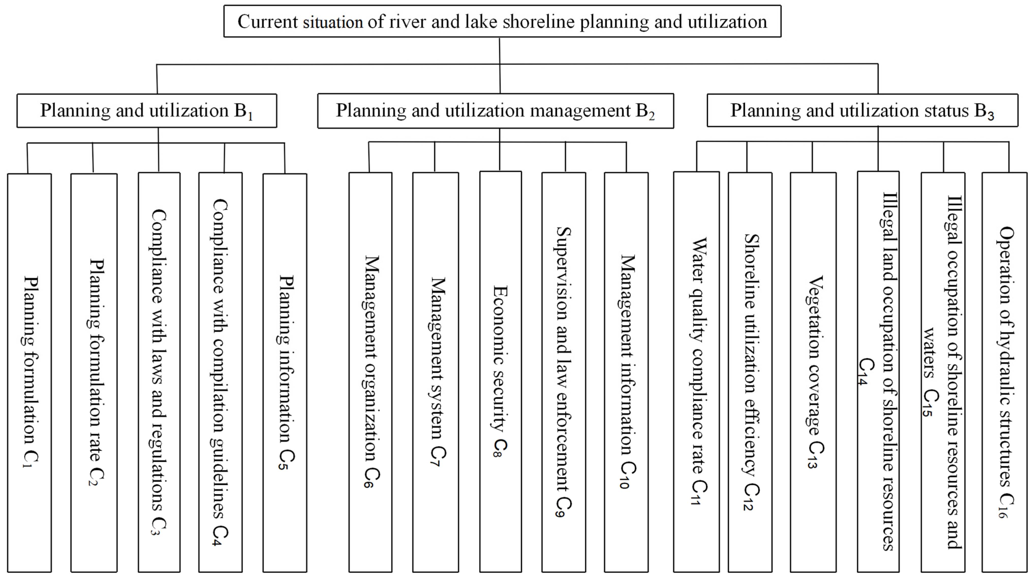
2. Evaluation Index System of Current Situation of River and Lake Shoreline Planning and Utilization

With the low utilization efficiency of river and lake shoreline resources and great pressure on ecology and environmental protection, illegal construction still exists, and it is difficult to crack down on illegal sand mining in border rivers. On the basis of data collection, expert investigation, and on-site investigation, according to the principles of scientific systematicity, comprehensiveness, operability, independence, and combination of qualitative and quantitative in the construction of the system, the grey whitening weight clustering model is used to analyze the river and lake shoreline evaluation indicators and optimized to determine the influencing factors.

2.1. Planning and Utilization Preparation

The “Guidelines for the Preparation of River and Lake Shoreline Protection and Utilization Planning (Trial)” issued by the Ministry of Water Resources emphasizes the importance of shoreline planning. It calls for local authorities to prioritize the development of these plans, diligently fulfill their planning responsibilities, adhere to stringent planning approval processes, and utilize planning constraints effectively. The execution of these planning tasks and the robust implementation of the associated management systems are integral to the assessment of the current state of river and lake shoreline planning and utilization. Compliance with the guidelines’ requirements is crucial. This includes ensuring that the planning content encompasses a comprehensive understanding of the current protection and utilization status, an analysis of river stability, and other relevant factors. The planning process should be grounded in applicable laws, regulations, and rules, which serve as the foundation for guiding the preparation work and ensuring efficient progress while maintaining high-quality standards.

2.2. Planning and Utilization Management

Planning and utilization management includes establishing organization, improving the legal system, strict law enforcement, strengthening law enforcement team building, etc. On the basis of existing river and lake management agencies, water conservancy public security police stations are set up to handle relevant cases in a timely manner, and water-related building projects are set up to accept and review, as well as oversight committees to clarify responsibilities and improve efficiency. Efficiently address and investigate issues arising from law enforcement practices and proactively facilitate the implementation of relevant policies. Strengthen punishment measures for violations of water-related structures and implement industry management and supervision according to the law. In the process of planning and utilization management, it is indispensable to establish relevant management agencies, adopt corresponding policies, propose management plans, supervise the implementation of management, and provide reliable economic guarantees. Ensure to leave clear and documented traces that serve as a foundation for identifying issues and that aid in the processes of supervision and inspection.

2.3. Current Status of Planning and Utilization

The current situation of planning and utilization mainly refers to the accumulation of objects in rivers and lakes that hinder the flow of floods, the reclamation of rivers and lakes without approval, the illegal occupation of land or water shoreline resources, the construction of hydraulic structures without approval, and the disorderly development of shorelines. Some shorelines have an unreasonable use layout, lack intensive, economical, and efficient use, and lack sustainable use planning, which are accompanied by problems such as water quality decline and vegetation coverage reduction, which weaken the potential use value of shorelines.
The evaluation index system of the status quo of river and lake shoreline planning and utilization is shown in Figure 1.

3. Evaluation Model of Current Situation of River and Lake Shoreline Planning and Utilization

3.1. Combined Weighting Method to Calculate Weights

3.1.1. Determining Weight Based on Triangular Fuzzy Number Method

Trigonometric fuzzy number multi-attribute decision-making represents a category of multi-criteria decision-making problems that utilize trigonometric fuzzy numbers to characterize attribute information within a discrete decision-making context [29,30]. The triangular fuzzy number method is an approach to describing the uncertainty of objective things by quantifying them. This method is more in line with people’s thinking habits, and experts are more willing to give the most ideal value, the most likely value, and the least ideal value of the evaluation scale than the traditional fuzzy evaluation of setting fixed values, which makes the evaluation results more reasonable and reliable. The general triangular fuzzy number can be written as G = ( X , Y , Z ) , and in the triangular fuzzy number, X and Z are used to indicate the fuzzy degree, and the smaller the ZX value, the lower the fuzzy degree and the steps are as follows:
(1) Expert scoring. Let the evaluation score given by the ith expert on the jth evaluation index be gij = [xij, yij, zij] (i = 1, 2,…, q). xij is the minimum value given by the ith expert on the influence degree of evaluation index j; yij is the most likely value given by the ith expert on the influence degree of index j; zij is the maximum value given by the ith expert on the degree of influence of indicator j;
(2) Determine the weight set of expert evaluation E = [e1, e2, e3,…, en], en is the proportion of the score value given by the nth expert standing in the composite score;
(3) Let the fuzzy synthesis matrix T = [x1, y1, z1], [x2, y2, z2],…, [xm,ym,zm]; tj is the jth term of the synthesis matrix T
t j = e j g j = [ x j , y j , z j ] ( j = 1 , 2 , 3 , , m )
where xj is the minimum value of evaluation index j; yj is the most probable value of evaluation index j; zj is the maximum value of evaluation index j. “ ” is the fuzzy synthesis operator, and the study uses the weighted average type operator M (⊗, ⊕) for fuzzy synthesis.
(4) Establish the weights for the triangular fuzzy numbers. The fuzzy score of the jth evaluation index is as follows:
v j = i = 1 q e i x i j + 2 i = 1 q e i y i j + i = 1 q e i z i j 4
The subjective weight ω z j of the jth evaluation index is as follows:
ω z j = v j / j = 1 m v j

3.1.2. Calculation of Weights Based on the Improved CRITIC Method

The CRITIC method is a method proposed by Diakoulaki to calculate objective weights, which not only considers the degree of variability of the data but also focuses on the correlation between them compared to the entropy weight method and the standard deviation method. It calculates the indicator weights by the relative strength of the indicators and the magnitude of the information measured by the standard deviation. It does not mean that the greater the variation of the value, the more important it is, but it is a scientific judgment made entirely by using the objective properties of the data. The standard deviation reflects the degree of difference in the values taken by each assessment scheme under the same indicator, and the larger the standard deviation, the greater the fluctuation. If there is a large positive correlation between the indicators, it means that the less conflicting they are, the lower the weights will be. The method is a more comprehensive objective weighting method and has been applied in many fields. The traditional CRITIC method is suitable for data with stability and indicators with certain correlation, but when the mean difference of indicator data is large, the standard deviation will be affected by the mean, so it needs to be improved by introducing the coefficient of variation for calculation, and the larger the value of the coefficient of variation, the more obvious the fluctuation and the more informative the improved of CRITIC method calculates more accurate indicator weights, and the steps are as follows:
Let the assessment matrix V = v k j , and standardize the values vkj taken for the evaluation indicators to obtain the matrix V :
V = v k j
v k j = ( v k j v ¯ j ) / s j , v ¯ j and s j denote the mean and standard deviation of the jth indicator, respectively.
The coefficient of variation u j for the jth indicator is as follows:
u j = s j v ¯ j
The correlation coefficient matrix R is obtained from the normalized matrix V :
R = r l j
r l j = k = 1 n v k l v l ¯ v k j v j ¯ k = 1 n v k l v l ¯ 2 v k j v j ¯ 2 = cov ( V l V j ) D V l D V j
In Equation (7), r l j denotes the correlation coefficient between the lth indicator and the jth indicator and cov ( V l V j ) denotes the covariance of V l and V j .
The composite factor Tj for indicator j is as follows:
T j = u j l = 1 n ( 1 r l j )
The objective weight ω k j of the jth evaluation indicator is as follows:
ω k j = T j j = 1 n T j

3.1.3. Minimum Discriminative Information Principle to Determine Portfolio Weights

In order to satisfy the requirement that the combination weights are as close as possible to the subjective and objective weights, the following function is established by combining the concept of minimum discriminative information:
min F = j = 1 n ω j ln ω j ω z j + j = 1 n ω j ln ω j ω k j
s . t . j = 1 n ω j = 1 ; ω j > 0
Introducing Lagrange multipliers to solve the above problem yields, we can obtain the following:
ω j = ω z j ω k j j = 1 n ω z j ω k j

3.2. Improved Matter-Element Extension Evaluation Model

3.2.1. The Principle of the Matter-Element Extension Model

Matter-element extension method is the result of the coupling of matter-element analysis and extension. The successful application of the matter-element extension method in some management fields can solve the problems of multi-objective and multi-complexity at the management level. The matter-element extension method has certain unique advantages compared with other methods. The main idea of matter-element analysis and extensibility is the transformation of contradictory problems because their main research direction is to analyze contradictory problems, make use of matter-element extensibility, construct matter-element models, study the expansion performance of things, and study things. The laws and methods of innovation turn contradictory problems into non-contradiction problems. Nowadays, the complexity and specialization of disciplines are becoming stronger and stronger, but this does not affect the applicability of matter-element analysis and extension to these complex disciplines. The combination of the two can not only highlight the independence of the discipline itself but also give full play to the synergistic effect of the two; the evaluation of the current situation of shoreline planning and utilization is fundamentally an evaluation of the affiliation degree of “superior” and “inferior” to the object to be evaluated, but the difference between the two does not exist as an absolute boundary but has certain differences gradually, with a certain degree of ambiguity. In the evaluation process, the results of superiority and inferiority are produced by comparison according to the established standards, and the correlation function in the matter-element analysis is a method that uses mathematical theory to accurately explain after the evaluation target and evaluation standard is established. Not only does this method allow for an assessment of the matter element under evaluation against specific criteria, but it also enables representation through precise numerical values. This approach fully captures the extent of the correlation between the two elements in question.
The model also has certain shortcomings; one is that the traditional matter-element extension model usually selects subjective assignment methods such as hierarchical analysis and an expert scoring method in the evaluation process, and its calculation results are too subjective; secondly, in the actual operation of the model, we observe that certain indicators are classified as “the higher, the better” or “the lower, the better”. There is no fixed value range for these indicators, and the actual values of the evaluation indicators frequently exceed the predefined range of the nodal domain. When calculating the correlation function, there will be a situation that cannot be calculated, which directly affects the calculation of the comprehensive correlation degree and leads to inaccurate comprehensive evaluation results. Third, the model uses the correlation degree to achieve the rating, while the principle chosen for the traditional matter-element extension model is the maximum affiliation principle, and this criterion uses the approximation processing to judge the evaluation grade, which leads to the loss of information and further leads to large uncertainty in the evaluation results. Therefore, the model needs to be improved.
To address the above limitations, the classical domain matrix and the matter-element matrix to be evaluated are normalized by dividing the original data by the upper bound of the nodal domain to form the new classical domain matrix and matter-element matrix to be evaluated, and then the maximum subordination principle is replaced by the asymmetric closeness principle, which can measure the closeness between two fuzzy sets to obtain more accurate evaluation results. The enhanced matter-element model effectively addresses the issue of incompatibility among evaluation indicators. It also eliminates the ambiguity and uncertainty associated with the evaluation levels, leading to a more robust and reliable assessment framework.

3.2.2. Improved Matter-Element Extension Model

Assuming that the name of the thing to be evaluated is N, the characteristic of the thing is C, and the characteristic value is V, then it is recorded as R = (N,C,V). The ordered triple composed of the three is called the basic matter-element. The current status of river and lake shoreline planning and utilization is defined as the basic matter-element R, then the level of the status quo is N, each evaluation index of the current situation is C, and the range of each evaluation index is V.
(1) Evaluation level determination.
The evaluation grade of the current situation of river and lake shoreline planning and utilization is divided into five levels, i.e., excellent, good, medium, little poor, and poor, which are expressed by S*, S* = {S*1, S*2, S*3, S*4, S*5}. The evaluation level and scoring criteria for the current situation of river and lake shoreline planning and utilization are shown in Table 1.
(2) Determining the classical domain.
R 0 = ( N 0 s * ,   C j ,   V 0 s * j ) = N 0 s * c 1 < a 0 s * 1 , b 0 s * 1 > c 2 < a 0 s * 2 , b 0 s * 2 > c j < a 0 s * j , b 0 s * j >
In Formula (12), R0 is the matter-element of the classical domain, N0s* is the s* evaluation level of the classical domain(s* = 1, 2,…, 5), Cj is the status quo evaluation index, j = 1, 2,…, n, V0s*j is the scoring standard of the s*th evaluation level of the jth index in the classical domain, a0s*j, b0s*j are the upper limit of the s*th evaluation level scoring standard of the jth index and lower limit.
(3) Determine the section field.
R P = ( N P ,   C j ,   V P ) = N P c 1 < a p 1 , b p 1 > c 2 < a p 2 , b p 2 > c n < a p j , b p j >
In Formula (13), RP is the matter-element of the node domain; NP is the individual to be measured for the status quo evaluation; ap and bpj are the lower and upper values of the jth index, respectively.
(4) Determine the matter element to be evaluated
R k = ( N k ,   C j ,   V k j ) = N k c 1 v 1 c 2 v 2 c j v j
In Formula (14), Rk is the matter element to be evaluated, Nk is the kth evaluation individual, k = 1, 2,…, m, and Vkj is the score of the jth evaluation index of the kth evaluation individual.
(5) Standardized processing
R 0 = ( N 0 s * ,   C j ,   V 0 s * j ) = N 0 s * c 1 < a 0 s * 1 b p 1 , b 0 s * 1 b p 1 > c 2 < a 0 s * 2 b p 2 , b 0 s * 2 b p 2 > c j < a 0 s * j b p j , b 0 s * j b p j >
R k = ( N k ,   C j ,   V k j ) = N k c 1 v 1 b p 1 c 2 v 2 b p 2 c j v j b p n
In Formulas (15) and (16), R 0 , R k are divided into normalized classical matter-element and evaluation matter-element.
(6) Calculation of closeness function values.
The closeness function formula is as follows:
H s * ( v k j ) = 1 1 n ( n + 1 ) j = 1 n D j ( v k j ) ω j
Formula (17) represents the asymmetric closeness function under the s*th evaluation level of the kth evaluation individual: D j ( v k j ) = v k j a 0 s * j + b 0 s * j 2 b 0 s * j a 0 s * j 2 is the distance between the matter-element to be evaluated and the classical domain.
(7) Determine the evaluation level.
The evaluation grade score named s of the Kth evaluation individual is as follows:
s = max { H s * ( v k j ) }
From Equation (18) and Table 1, the evaluation level of the current status of planning and utilization of the object to be evaluated can be determined.
H ¯ s * ( v k j ) = H s * ( v k j ) m i n s * = 1 5 { H s * ( v k j ) } m a x s * = 1 5 { H s * ( v k j ) } m i n s * = 1 5 { H s * ( v k j ) }
s * * = s * = 1 5 s * H ¯ s * ( v k j ) s * = 1 5 H ¯ s * ( v k j )
In Formula (20), s * * is the variable characteristic value of the matter element R k to be evaluated, which can judge the degree of its bias towards adjacent levels and sort the objects to be evaluated under the same level.

4. Evaluation of the Current Situation of River and Lake Shoreline Planning and Utilization in a Typical Region

According to the geographic location and regional economic and social development level of different regions of the country, and then combined with the shoreline characteristics of rivers in different regions, five typical regions in East China, South China, Northwest China, North China, and Central China are selected as the research objects. Since the number of rivers and lakes within the typical regions is large, if all rivers and lakes are analyzed and evaluated, the resources and time required will be greatly increased, so a certain number of representative rivers and lakes can be selected from the typical regions by random sampling method for analysis and evaluation, and the results can be used as the overall regional status evaluation results. As shown in Figure 2.

4.1. Calculation of Indicator Weights

Using the basic principles of the triangular fuzzy number method and the improved CRITIC method, the results of 30 questionnaires were used as the original data, and the mean values of the scores of the questionnaires were rounded to calculate the combination weights of the shoreline planning and utilization status indicators according to Equations (1)–(11). The calculation process is as follows.
Three experts with more seniority were selected from the nine experts in the index preference to participate in the scoring, and the weight set of experts was E = [0.31, 0.32, 0.37], and the evaluation index weights were calculated as shown in Table 2.

4.2. Evaluation of the Current Situation of Shoreline Planning and Utilization Based on Different Models

4.2.1. Current Situation Evaluation of Shoreline Planning and Utilization Based on Improved Matter-Element Extension Model

According to the basic situation of the shoreline and related data, the scoring standards of the current situation of the classical domain matter-element and the segmental matter-element index of river and lake shoreline planning are shown in Table 3.
From Formula (12), the matter-element matrices of typical regions to be evaluated are as follows:
R A = N A C 1 95 C 2 94 C 16 90   R B = N B C 1 88 C 2 90 C 16 92   R C = N C C 1 75 C 2 72 C 16 86
R D = N D C 1 72 C 2 72 C 16 85   R E = N E C 1 75 C 2 80 C 16 83
The normalized matter-element matrix R k to be evaluated is as follows:
R A = N A C 1 0.95 C 2 0.94 C 16 0.90   R B = N B C 1 0.88 C 2 0.90 C 16 0.92   R C = N C C 1 0.75 C 2 0.72 C 16 0.86
R D = N D C 1 0.72 C 2 0.72 C 16 0.85   R E = N E C 1 0.75 C 2 0.80 C 16 0.83
The evaluation results and ranking of the matter-element model are as follows:
(1) Value of closeness function.
According to the obtained evaluation index combination weights with Equation (17), the results of the closeness function are shown in Table 4.
(2) Evaluation grade and ranking.
The evaluation level is judged according to Formula (18), and then the evaluation objects at the same level are sorted by Formulas (19) and (20). Taking area E and area D as examples, the S** of area E is 2.34, indicating that its shoreline The status quo of planning and utilization is more favorable; the S** of area D is 2.37, indicating that the current status of planning and utilization of the shoreline is also favored to be good, but not as good as that of area E, so area E is worse than area D. The same level area is the same as above, and the matter-element model evaluation results and ranking are shown in Table 5.

4.2.2. Evaluation of the Current Situation of Shoreline Planning and Utilization Based on the TOPSIS Method

The TOPSIS method is a common and effective method in multi-objective decision analysis, which is also called the distance method of optimal and inferior solutions. Its basic principle is to rank the evaluation object by detecting the distance between it and the optimal solution and the inferior solution; if the evaluation object is closest to the optimal solution and at the same time farthest from the inferior solution, it is the best; otherwise it is not optimal. At present, it is widely used in the fields of economy, management, and energy [31,32,33,34,35]. The distance, relative closeness, and ranking of the “optimal ideal solution” and “inferior ideal solution” of each object to be evaluated are shown in Table 6.

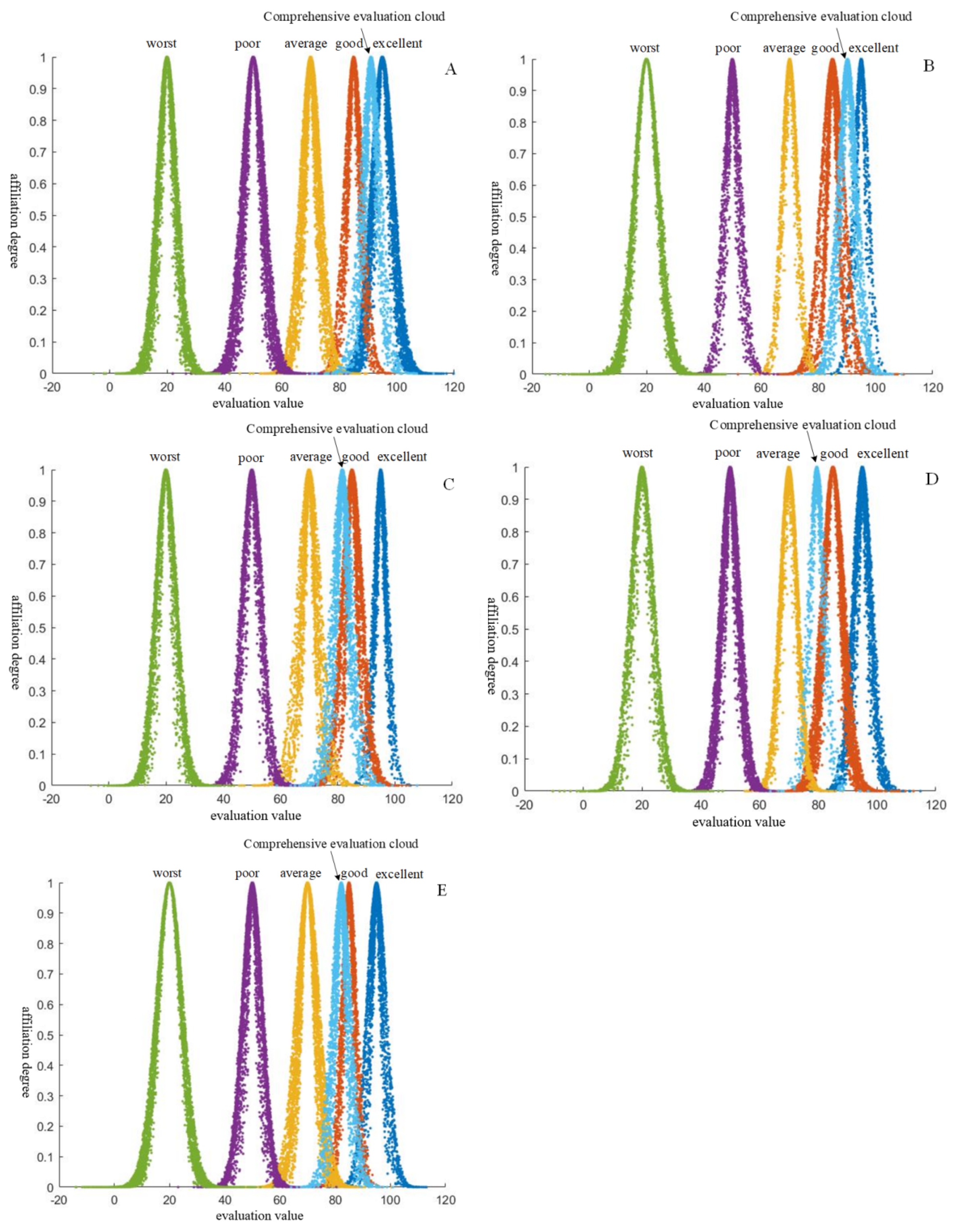
4.2.3. Evaluation of the Current Situation of River and Lake Shoreline Planning and Utilization Based on Cloud Model

The cloud model-based system evaluation method selects the key indicators in the system [36] and then expresses the qualitative indicators in a normal cloud, according to the hierarchical structure of the system indicators, in a more objective comprehensive evaluation of the system under uncertainty, the cloud model used in this paper is a normal cloud model. The calculated comprehensive evaluation cloud for each typical region is shown in Figure 3.
From the figure, it can be seen that most of the comprehensive evaluation clouds in the typical region A are distributed in “excellent”, and the remaining few are distributed in “good”, so the comprehensive evaluation clouds are closer to “excellent”. Therefore, the overall evaluation cloud is closer to “excellent”; that is, the evaluation grade of the current situation of shoreline planning and utilization in Region A is “excellent”. The rest of the typical areas are “excellent”, “good”, “good”, and “good”, in order.

4.2.4. Comparative Analysis of Evaluation Methods

In this instance, the enhanced matter-element extension method was chosen for a comparative analysis with both the TOPSIS method and the cloud model. This involved conducting a pairwise comparison to assess the ranking of evaluation objects and to determine the level of evaluation results accordingly. There are differences, all of which are that area A is optimal, only the order of area C and area D changes; this is because the TOPSIS method cannot well reflect the difference between the change trend of each index within the evaluation scheme and the ideal scheme, and matter-element extension The improved model effectively addresses the incompatibility between evaluation indicators, convert multi-objective evaluation into single-objective evaluation, and connect the evaluation object with the evaluation index through the correlation function, and the evaluation result is more accurate; The rating results of the cloud model are consistent with the matter-element extension method, which verifies the accuracy of the evaluation results. At the same time, both of them take into account the fuzziness of the data and the principle of combining qualitative and quantitative. However, the data of the cloud model is uncertain. The calculation results of the same set of data are not necessarily the same. For the evaluation of the current situation of river and lake shoreline planning and utilization, the evaluation results should be dynamic and effective, not belonging or not, and the current situation is subject to constant change over time. The matter-element extension method adeptly resolves the issue of incompatibility between evaluation levels, revealing a transitional dynamic where one level exhibits a propensity to evolve into another. The evaluation system of matter-element extension method is flexible, and it can adapt to different evaluation requirements by adjusting the node domain and classical domain of the matter-element to be evaluated. To sum up, the improved matter-element extension model is more feasible and accurate in the evaluation of the status quo of river and lake shoreline planning and utilization.

4.3. Analysis of Evaluation Results

The best evaluation of area A is mainly due to the rapid progress of the preparation of the shoreline planning, the advanced layout, the rational planning, the strong promotion, and the smooth implementation of various institutional guarantees. The late start and the lag in the preparation schedule make the supervision of river and lake shorelines need to be greatly improved. Area E has a small number of compilations and relatively light tasks, so the compilation speed is relatively fast. Because the results are not included in the information construction of a map of water conservancy, the scoring value is delayed. Region A and Region B have achieved good results in shoreline supervision. The shoreline management systems and capabilities, the construction of water conservancy informatization, the development of shoreline supervision and law enforcement actions, and the effectiveness of supervision are all relatively balanced, with little gap between them.
On the basis of determining the current status of shorelines, the concept of ranking the advantages and disadvantages is proposed, which can provide certain decision-making assistance for the planning and utilization of shorelines in various regions. The ranking of the advantages and disadvantages of the evaluation level determines the advantages and disadvantages of the shoreline planning and utilization under the same evaluation level, referring to the shoreline planning and utilization level and management mode of the better area and learning from each other’s strengths. To sum up, the evaluation method of shoreline planning and utilization status proposed in this paper has good practicability.

5. Conclusions

This paper conducts a study on the current situation of river and lake shoreline planning and utilization and uses the principle of minimum discriminative information to calculate the combination weights. This method resolves the limitations of using either subjective or objective weighting alone, enhancing the objectivity and accuracy of the evaluation results. An improved matter-element extension model is established to evaluate the current situation of shoreline planning and utilization. Under the premise of analyzing the shortcomings of the current weighting methods, this paper proposes a weight calculation method based on the fusion of the triangular fuzzy number method and the improved CRITIC method, which utilizes the principle of minimum discriminative information to calculate the combined weights. This weighting method overcomes the drawbacks of using separate subjective or objective weighting methods and further improves the objectivity and accuracy of the evaluation results. Taking a typical area as an example, the TOPSIS method and the cloud model evaluation method are compared with the evaluation results of the matter-element model. The former compares the ranking of the evaluation objects, and the latter compares the evaluation levels, and the results show good agreement between all. The limitations of the traditional thing element model are analyzed; one is that there is no fixed value space for the indicator values, and the actual values of the evaluation indicators are often beyond the range of the section domain values, which cannot be calculated when calculating the correlation function and directly affects the calculation of the comprehensive correlation degree. Secondly, the model uses the correlation degree to realize the rating, but the correlation degree is based on the principle of maximum affiliation degree, which cannot reflect the ambiguity of the object to be evaluated and leads to the loss of information. The improved matter-element model can fully consider the incompatibility between indicators and the fuzziness and uncertainty of the evaluation level boundaries, which can more clearly reflect the evaluation results of the current situation of shoreline planning and utilization in each typical area of flexibility and is more feasible in the evaluation of the current situation of river and lake shoreline planning and utilization.

Author Contributions

Conceptualization, B.W. and S.L.; methodology, B.W.; software, X.Z.; validation, S.L. and K.Y.; formal analysis, X.Z.; investigation, S.L.; resources, K.Y; data curation, B.W.; writing—original draft preparation, S.L.; writing—review and editing, K.Y.; visualization, X.Z.; supervision, S.L. and F.L.; project administration, B.W.; funding acquisition, B.W. All authors have read and agreed to the published version of the manuscript.

Funding

This research received no external funding.

Conflicts of Interest

The authors declare no conflict of interest.

References

  1. Chu, V.C.; Michael, R.; Sharon, B. Using shoreline video Assessment for coastal planning and restoration in the context of climate change in Kien Giang, Vietnam. Ocean. Sci. J. 2015, 50, 413–432. [Google Scholar]
  2. David, G.; Chris, H.; Rangel-Buritago, N. An assessment of areal and transect-based historic shoreline changes in the context of coastal planning. J. Coast. Conserv. 2019, 23, 315–330. [Google Scholar]
  3. Zhang, X.; Shen, K. Reflections on the protection and utilization of the Yangtze River shoreline under the new situation. Water Resour. Hydropower Express 2018, 39, 8–11. [Google Scholar]
  4. Wang, C.; Li, J.; Sun, X. Evaluation and development and utilization of coastline resources in the Jiujiang-Xinjizhou section of the main stream of the Yangtze River. Resour. Sci. 2002, 3, 71–78. [Google Scholar]
  5. Yang, Y.; Han, Z. Comprehensive evaluation of coastal port site resources in Liaoning Province and its geographical combination. Geogr. Res. 2000, 1, 65–72. [Google Scholar]
  6. Cao, W.; Cao, Y.; Wu, W.; Liang, S. Study on shoreline resource evaluation and port development in Chaohu section of Yangtze River. Hum. Geogr. 2008, 3, 64–68. [Google Scholar]
  7. Duan, X.; Zou, H. Spatial functions, development problems and management countermeasures of the Yangtze River shoreline. Geoscience 2016, 36, 1822–1833. [Google Scholar]
  8. Tian, H.; Liu, X.; Wang, H.; Shi, Y.; Li, Q.; Wang, Y. Characterization of the spatial and temporal evolution of the Caofeidian shoreline island over the past three decades. Mar. Sci. 2015, 39, 68–74. [Google Scholar]
  9. Bin, G.; Li, X.; Dhillon, B.S.; Chu, W. A new method for quantitative evaluation of equipment condition system based on fuzzy hierarchical analysis. Syst. Eng. Theory Pract. 2010, 30, 744–750. [Google Scholar]
  10. Propana, O.A.; Kyung, N.K. Analysis of Indonesia’s priority selection: Energy transition, energy-related measures, mining governance, and resource transition using the analytic hierarchy process (AHP). Energy Sustain. Dev. 2024, 83, 101559. [Google Scholar]
  11. Yang, W.; Li, J. Safety Risk Analysis of Assembly Building Lifting Construction Based on Dynamic Bayesian Network. J. Saf. Environ. 2024, 24, 1329–1331. [Google Scholar]
  12. Chen, X.; Lin, W.; Huang, X.; Yang, F. Firne Risk Assessment of Ultra-High-Rise Buildings Based on Fuzzy Bayesian Network. Saf. Environ. Eng. 2023, 30, 44–45. [Google Scholar]
  13. Chen, Y.; Wu, G.; Zhang, Y.; Li, G. Operation and maintenance risk analysis of urban underground comprehensive pipeline corridor based on fuzzy Bayesian network. Saf. Environ. Eng. 2021, 28, 65–69. [Google Scholar]
  14. Zhang, J.; Huang, D.; You, Q.; Kang, J.; Liu, M.; Guo, Y. Dynamic risk evaluation of gas leakage in urban integrated pipeline corridors based on dynamic Bayesian network. J. Saf. Environ. 2023, 23, 2456–2458. [Google Scholar]
  15. Landuyt, D.; Broekx, S.; Goethals, P.L. Bayesian belief networks to analyse trade-offs among ecosystem services at the regional scale. Ecol. Indic. 2016, 71, 327–335. [Google Scholar] [CrossRef]
  16. Hu, M.; Fu., C.; Deng., J.; Luo, Y.; Han, H. Analysis of shoreline resource utilization of Yangtze River based on fuzzy comprehensive evaluation method. People’s Yangtze River 2021, 52, 42–48. [Google Scholar]
  17. Wan, T.; Cheng, F.; Cheng, Y.; Liao, C.; Bai, Y. Investigation into effect of non-uniform thermal environment on thermal sensation under stratum ventilation for heating by using interpolation-based multi-level fuzzy comprehensive evaluation. J. Build. Eng. 2023, 64, 105592. [Google Scholar] [CrossRef]
  18. Qu, Z.; Tian, X.; Xie, G.; Wu, Y.; Wang, H. Fuzzy comprehensive evaluation of high parameter waste power station corrosion prevention system based on hierarchical analysis method. Corros. Prot. 2024, 45, 91–96. [Google Scholar]
  19. Ye, Y.; Liang, L.; Cao, Y.; Zhou, Z.; Gong, J.; Zhao, H.; Jiang, Y. Preferential selection and ranking method for planning layout scheme of river-lake water system connectivity project based on Vague set and cloud model. Syst. Eng. Theory Pract. 2017, 37, 1926–1936. [Google Scholar]
  20. Mu, R.; Zhang, J. Hierarchical comprehensive evaluation based on grey correlation analysis. Syst. Eng. Theory Pract. 2008, 10, 125–130. [Google Scholar]
  21. Yang, W.; Yang, D.; Xie, Q. A cloud model-based slope risk assessment method and its application. J. Huazhong Univ. Sci. Technol. (Nat. Sci. Ed.) 2018, 46, 30–34. [Google Scholar]
  22. Zhu, J.; Zhang, J.; Qin, C. Multi-objective optimization of group decision-making based on matter-element extension set. Can. Soc. Sci. 2009, 5, 90–103. [Google Scholar]
  23. Lu, R.; Chen, Z. Matter-element modeling of parallel structure and application about extension PID control system. J. Syst. Sci. Complex. 2006, 19, 227–235. [Google Scholar] [CrossRef]
  24. Yu, W.; Jia, C.; Di, S.; Li, K.; Yuan, H. Groundwater quality evaluation based on comprehensive weight and improved material element topologizable evaluation model. J. Jilin Univ. (Earth Sci. Ed.) 2019, 49, 539–547. [Google Scholar]
  25. Wang, R.; Liao, P.; Han, X. Comprehensive benefit evaluation of watershed management based on the material element topologizable model. Water Resour. Hydropower Technol. 2018, 49, 29–35. [Google Scholar]
  26. Yi, X.; Zhang, L.; Zhang, J.; Li, B.; Jiao, A. Topologically scalable evaluation of material elements for green manufacturing process optimization. Manuf. Autom. 2019, 41, 118–121. [Google Scholar]
  27. Huang, C.; Wu, X.; Lin, M.; Xu, Z. Reliability assessment of multi-stage task systems based on triangular intuitionistic fuzzy numbers, Operations. Res. Manag. 2024, 33, 3–4. [Google Scholar]
  28. Zhang, L.; Shi, Y.; Liu, H.; Li, F. Research on the initial water right allocation of reservoirs based on the theory of material elemental topology. China Popul. -Resour. Environ. 2019, 29, 110–117. [Google Scholar]
  29. Wang, S.; Cen, Y. A triangular fuzzy number method for sequencing decision. Ind. Eng. Manag. 2009, 14, 44–47. [Google Scholar]
  30. Razmi, J.; Seifoory, M.; Pishvaee, M.S. A fuzzy multi-attribute decision making model for selecting the best supply Chain strategy lean, agile or leagile. J. Ind. Eng. 2011, 45, 127–142. [Google Scholar]
  31. Chen, C. Extensions of the TOPSIS for group decision making under fuzzy environment. Fuzzy Sets Syst. 2000, 114, 1–9. [Google Scholar] [CrossRef]
  32. Wang, T.; Chang, T. Application of TOPSIS in evaluating initial training aircraft under a fuzzy environment. Expert Syst. Appl. 2007, 33, 870–880. [Google Scholar] [CrossRef]
  33. Wang, J.; Cheng, C.; Huang, K. Fuzzy hierarchical TOPSIS for supplier selection. Appl. Soft Comput. 2009, 9, 377–386. [Google Scholar] [CrossRef]
  34. Wang, J. Multi-objective decision ideal point method for comprehensive evaluation of groundwater environmental quality in Huabei. Environ. Sci. Manag. 2005, 4, 111–112. [Google Scholar]
  35. Xu, X.; Liu, J.; Wang, Z. Enterprise evaluation model and empirical research based on entropy TOPSIS method. J. Intell. 2011, 4, 78–82. [Google Scholar]
  36. Zhang, M.; Wang, S.; Sun, Z.; Xu, Z.; Wang, H. Comprehensive evaluation of oil and gas pipeline landslide hazard based on cloud theory. J. Eng. Sci. 2018, 40, 427–437. [Google Scholar]
Figure 1. Evaluation index system of current situation of river lake shoreline planning and utilization.
Applsci 14 09857 g001
Figure 2. Statistics of rivers above the Designated Size in all provinces of China.
Applsci 14 09857 g002
Figure 3. Comprehensive evaluation cloud map of typical provinces and regions. (A) denotes a typical region A The comprehensive evaluation cloud is obtained by overlaying the comprehensive evaluation cloud with the standard map. (BE) ditto as above.
Applsci 14 09857 g003
Table 1. Evaluation grade and scoring standard of the current situation of river lake shoreline planning and utilization.
Evaluation LevelExcellentGoodMediumLittle PoorPoor
Score(90, 100)(80, 90)(60, 80)(40, 60)(0, 40)
Table 2. Evaluation index weight calculation.
Expert/MandarinExpert 1Expert 2Expert 3 ω z j ω k j ω j
Index
C1[69, 75, 91][75, 80, 93][67, 85, 92]0.06480.10290.0839
C2[61, 72, 85][73, 80, 89][69, 81, 90]0.06240.08380.0743
C3[63, 71, 84][65, 75, 85][71, 80, 91]0.06160.04510.0542
C4[69, 75, 91][75, 80, 93][67, 85, 92]0.06480.09730.0816
C5[70, 82, 92][68, 79, 89][70, 85, 95]0.06480.11310.088
C6[62, 71, 80][65, 75, 85][70, 79, 89]0.06000.03280.0456
C7[63, 75, 80][65, 75, 87][70, 85, 95]0.06240.06210.064
C8[63, 70, 85][70, 82, 92][68, 79, 95]0.06240.08830.0763
C9[61, 72, 88][73, 80, 89][69, 81, 93]0.06320.02820.0434
C10[70, 82, 92][68, 79, 89][70, 85, 95]0.06480.04210.0537
C11[63, 70, 85][65, 76, 90][68, 79, 93]0.06080.08230.0727
C12[70, 82, 92][68, 79, 89][70, 85, 95]0.06480.03900.0517
C13[61, 75, 83][65, 72, 88][64, 78, 86]0.06000.01520.031
C14[65, 75, 85][62, 77, 89][66, 79, 93]0.06160.06540.0653
C15[65, 75, 85][62, 77, 91][66, 79, 93]0.06160.06000.0625
C16[61, 75, 83][65, 72, 88][64, 78, 86]0.06000.04240.0518
Table 3. Current situation of river lake shoreline planning and utilization: scoring standard of matter-element index in classical domain and matter-element index in node domain.
IndexExcellent (S1)Good (S2)Medium (S3)Little Poor (S4)Poor (S5)Section Field
C1(90, 100)(80, 90)(60, 80)(40, 60)(0, 40)(0, 100)
C2(90, 100)(80, 90)(60, 80)(40, 60)(0, 40)(0, 100)
(90, 100)(80, 90)(60, 80)(40, 60)(0, 40)(0, 100)
C15(90, 100)(80, 90)(60, 80)(40, 60)(0, 40)(0, 100)
C16(90, 100)(80, 90)(60, 80)(40, 60)(0, 40)(0, 100)
Table 4. Closeness function result.
Typical AreaH1H2H3H4H5
A1.0000.9960.9620.8880.815
B0.9990.9970.9640.8900.817
C0.9701.0020.9920.9190.845
D0.9650.9990.9980.9250.852
E0.9711.0010.9930.9340.876
Table 5. Evaluation results and ranking of matter-element model.
Typical AreasJudgment ResultsS**
A0.991Excellent1
B0.997Excellent2
C0.998Good3
D0.999Good5
E0.997Good4
Table 6. Distance, relative closeness, and result ranking of “optimal ideal solution” and “worst ideal solution” of each object to be evaluated.
Typical AreaOptimal Ideal Solution DistanceWorst Ideal Solution DistanceRelative ClosenessSort Results
A0.07770.22720.74511
B0.08230.21510.72322
C0.19990.09500.32234
D0.23550.04510.16095
E0.19490.12060.38233
Disclaimer/Publisher’s Note: The statements, opinions and data contained in all publications are solely those of the individual author(s) and contributor(s) and not of MDPI and/or the editor(s). MDPI and/or the editor(s) disclaim responsibility for any injury to people or property resulting from any ideas, methods, instructions or products referred to in the content.

