Abstract
This article discusses a method for analyzing the layered structure of soil using the phase-metric method of geoelectric monitoring to ensure the reliability of a railway track. The importance of monitoring soil layers for timely detection of changes that may affect the stability and safety of railway tracks is emphasized. The use of geophysical monitoring methods, such as phase monitoring of the geoelectric signals, allows us to optimize measures to strengthen the roadway and increase its durability. The present article describes laboratory experiments in which a specialized setup was created to simulate the process of drilling through various soil layers. Geoelectric methods involving the registration of phase characteristics of the electromagnetic field were used in an experimental setup. The experiments demonstrated the effectiveness of the phase-metric method for determining the characteristics of the layered structure of the soil. The results showed that the change in the phase of the signal recorded at the receiving electrodes can be used to identify different soil layers with different electrical characteristics, such as moisture and density. The method of modeling the physical and geological environment using equivalent circuits of elements in the form of a dielectric made it possible to more accurately analyze the electrical properties of the soil. Based on the obtained data, an automatic monitoring system was developed using recurrent neural networks (RNNs), in particular long short-term memory (LSTM) networks, for automatic detection of bends and transitions in signal time series. Evaluation of the model’s effectiveness showed high accuracy in identifying layers, which contributes to increasing the reliability and efficiency of monitoring the condition of the railway track.
1. Introduction
Ensuring the stability and safety of railway infrastructure is one of the key tasks of the transport industry. The soil condition on which the railway track is located directly affects its reliability and durability. Changes in the layered structure of the soil can lead to serious problems such as track subsidence, differential settlements, and deformations, which can ultimately cause accidents and disruptions in train traffic [1].
Traditional methods of monitoring soil conditions, including electrical resistivity tomography and seismic surveys, are widely used to assess soil properties. However, these methods have several limitations: low resolution in heterogeneous media, high sensitivity to external interference, and the need for complex and time-consuming data processing [2,3]. These shortcomings make it difficult to promptly detect critical changes in the soil and take prompt measures to prevent accidents.
However, despite their effectiveness, traditional geophysical methods have certain limitations. For example, electrical resistivity tomography may struggle with resolution in highly heterogeneous soils, and seismic surveys can be influenced by external noise and require extensive data processing. The accuracy and reliability of these methods can be reduced in challenging geological environments, which underscores the need for advanced approaches that address these shortcomings [3].
Recent advancements in geophysical monitoring have introduced innovative techniques that offer enhanced precision and efficiency [4,5]. For instance, methods that monitor changes in the phase of electric signals at electrode receiver lines have shown promise in overcoming some of the limitations of traditional methods. These phase-metric techniques leverage the sensitivity of phase changes to variations in soil characteristics [6].
The main information that needs to be obtained is the following: the granulometric characteristics of the soil, porosity, moisture level, degree of plasticity and deformation of layers, and depth of groundwater [7,8]. While direct geophysical monitoring methods offer detailed insights, their application in railway tracks presents significant technical and economic challenges. Recent advancements in geophysical techniques could potentially address these limitations and improve the feasibility of comprehensive soil monitoring [9].
Previously, the authors of the present work obtained the following original scientific results on the current topic [6]:
- -
- A methodology for applying phase-metric methods of geodynamic monitoring in various tasks;
- -
- A method for forming an artificial multiphase field of a given structure in a controlled area of the near-surface part of the geological environment, allowing for observation of various geodynamic processes under various measurement conditions;
- -
- Methods for recording phase parameters and characteristics of a multiphase field by a single-point pole receiver and a differential pair, allowing for increased sensitivity of measurements and solving problems of spatial localization of geodynamic processes in a controlled area;
- -
- A method for receiving and primarily converting measured signals recorded by point pole receivers in the field of geodynamic monitoring systems based on phase-metric monitoring methods and devices, allowing for real-time assessment of phase parameters and characteristics of a multiphase field in a controlled area of the geological environment.
This study proposes an innovative approach based on the phase-metric method of geoelectric monitoring, which will allow for highly accurate determination of soil characteristics by analyzing phase changes in electrical signals [10,11,12].
The main contributions of our study are as follows: a laboratory setup for simulating the drilling process through different soil layers was developed and we conducted experiments to measure phase fluctuations of the recorded signals; a study was conducted on the effectiveness of the phaseometric method in detecting and identifying different soil layers (by monitoring changes in the humidity and density of the near-surface part of the geological environment of the railway roadbed); and taking into account their electrical characteristics, the use of recurrent neural networks (RNNs) and long short-term memory (LSTM) networks in automated soil probing systems was proposed.
Thus, this study aims to develop a method for obtaining information about the layered structure of the soil on which the railway track is located, using phase-metric geophysical control methods.
2. A Description of the Laboratory Experiment
The most promising approaches for the automated monitoring of railway roadbeds are geoelectric probing methods [13]. These methods are particularly promising for assessing the layered structure of soil beneath railway tracks, where even minor variations can significantly impact track stability [14]. The ability to accurately observe and assess geological formations, coupled with advanced predictive analysis capabilities, is essential for maintaining the integrity of railway infrastructure. The use of vector measurement systems that register phase characteristics of the electromagnetic field enhances the precision of soil monitoring by reducing data ambiguity and improving the reliability of the information used to manage and reinforce railway tracks [15,16]. Phase-metric systems are used under both laboratory and field conditions. They are fundamental for geoelectric control, which plays a critical role in detecting and localizing geodynamic processes that could affect railway stability [17,18].
Different layers of rocks may differ in moisture saturation and granulometric composition, which in turn affects the change in their electrical characteristics. In this context, the objects of control are the process equipment, the well, and the surrounding soil.
A method for modeling the physical and geological environment involves using equivalent circuits represented as dielectrics [18,19]. This method states that an equivalent circuit containing parallel or series-connected active and capacitive resistances can be an electrical model for analyzing the studied environment. Geophysical measurement data, such as electric current, electric field, seismic waves, and other physical parameters, are used during modeling. These measurements are used to calculate active and capacitive resistances in the equivalent circuit of the model.
This approach allows for a detailed study of the physical properties of the soil, such as its electrical conductivity and permittivity. In addition, this method enables the determination of geological parameters such as the depth and distribution of different soil layers, which enriches our understanding of the physical processes in the geological environment. In our case, the geological environment is abstracted as connected particle equivalent circuits, where each particle represents a microregion of the studied environment. To analyze the electrical properties, the cell encompassing the environment and the object of study are described by two resistances: R1 and R2. R1 is a resistance that characterizes the dielectric properties of the environment and is purely reactive. This resistance is associated with permittivity and affects the ability of the environment to respond to an alternating electric field. Resistance R2 is a parallel connection of the active resistances of two different environments. This reflects the consideration of the specific resistance of the objects being isolated, which may differ from the surrounding environment. This approach allows for a more accurate consideration of the influence of geological formations, such as mineral inclusions or water layers, on the electrical conductivity of the overall environment. Thus, the proposed model integrates the concepts of reactive and active resistance, as well as the specific resistance of objects, for a detailed study of the electrical conductivity of the geological environment. Analysis of these parameters using the particle substitution scheme allows for more in-depth studies related to the influence of geological formations on the electrical properties of the environment.
When modeling a medium, a complex electrical circuit arises because of connecting cells, which can be calculated using the nodal potential method (NPM). The main advantage of the NPM is its ability to effectively describe complex electrical circuits, including modeling a medium with many cells. The NPM is widely used in many software packages for analyzing electrical circuits, which provides a convenient and accessible platform for modeling geophysical processes. As a result, we can consider complex interactions between elements of the medium and, consequently, the possibility of studying various scenarios and impacts on the model.
The representation of the transfer function of the studied section of the geological environment in the form of a geoelectric model of series-connected complex resistances [17] makes it possible to use the model of an N-layer imperfect dielectric. The given model contains N elements with layer thickness d and electrical parameters of the i-th element: dielectric constant, εi, and specific electrical resistance, . The transfer function of a soil foundation fragment can be described by a set of series-connected RC (Resistance-Capacity) circuits with parameters as follows [17]:
where S(jϖ) is the effective area of a soil base fragment, determined considering the skin effect, d is the layer thickness, εi is the dielectric constant, and is the specific electrical resistance.
If we neglect the influence of grounding parameters, the transfer function of the geoelectric section can be equivalently represented by the model of a layered imperfect dielectric:
where xi = ωRiCi = ωεiρi.
In the absence of defects and deformations in the system “soil base—roadbed—railway track”, the geoelectric signal recorded by the geodynamic control system in operator form is defined as
where n is the number of horizontal layers, and m is the number of vertical sections in each layer. Changing the characteristics of the layers of the geological section causes variations in the transfer function H(p) and changes the recorded response:
From this expression, it is evident that the amplitude–phase characteristics of the recorded geoelectric signals will contain complete information about the transfer function and characteristics of the hydrogeological environment section. At the same time, from the theory and experience of practical use [18], it is known that the control of phase characteristics will have greater sensitivity, accuracy, and noise immunity, which makes it possible to diagnose geodynamic indicators of the initial stage of occurrence of defects and deformations of the roadbed of the railway.
To assess the prospects of using the phaseometric method in the task of obtaining information about the properties of the soil, laboratory modeling of the natural–technical system “soil-probing drill” was carried out. For this purpose, a laboratory setup was created, the diagram of which is shown in Figure 1. Electrodes A and B are for input signals, with a phase difference of 90°, and electrodes M1, M2, M3, N1, N2, and N3 are for the resulting output signals.
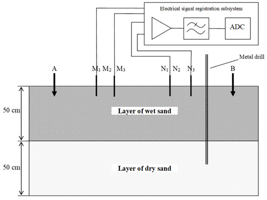
Figure 1.
Experimental setup diagram.
Each of the point sources generates an electric field signal of the following type:
where is the electric signal recorded before the drill was driven into the ground; is the anomalous component of the electric field caused by the presence of the drill in the ground, causing a change in the electrical characteristics of the soil.
3. Results
During the experiment, the drill was inserted into different soil layers beneath the railway track.
The control zone was a specially artificially organized section of the railway roadbed, for which dry sand (specific electrical resistance ρ ≈ 300 kOhm∙m) or a sand and gravel mixture (5 in the figure) was used as the upper ballast layer (cushion). The following parameters of the measuring setup and experimental conditions were used: a temperature of the near-surface part of the geological environment of +18 °C; pH of 6.5; frequencies of probing electrical signals of 166 Hz; amplitudes of the probing electrical signals of 80 V; a sampling frequency of the analog-to-digital converter of the receiving path of the measuring system of 10,101 Hz; the type of geoelectric setup—radial (consisting of two emitters and six receivers); a distance between emitters of 12 m; and a distance between receivers of 3 m.
The diagram of the measuring setup is shown in Figure 2, where A and B are emitters, and M and N are field receivers.
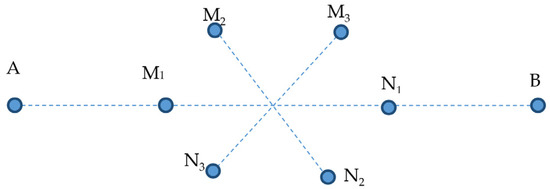
Figure 2.
Layout of electrodes in measuring setup (A,B—input signal electrodes, M1M2M3N1N2N3—output signal electrodes).
The immersion process was conducted in stages, starting from the 80 s mark and continuing at 50 s intervals, with a drill penetration step of 10 cm. Voltage changes on the receiving electrodes were recorded with a sampling frequency of 10,101 Hz. The phase shift of the output signals (see Figure 3 and Figure 4) was monitored during the drill’s passage through various soil layers. Observations showed that the phase of the electrical signals varied as the drill moved through layers with distinct electrical characteristics, which is crucial for assessing the impact of different soil layers on railway track stability.
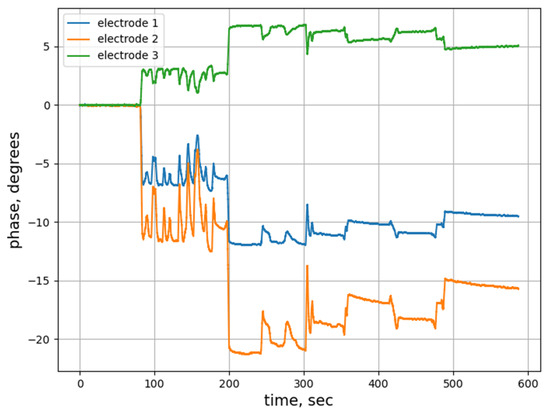
Figure 3.
Output signal phase change (experiment 1).
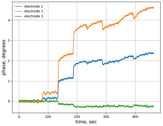
Figure 4.
Output signal phase change (experiment 2).
Studies have demonstrated that the extent of phase change in the signal is strongly influenced by the depth and electrical characteristics of the soil layers. This information is critical for assessing the operational reliability of the railway roadbed, as variations in soil properties can lead to differential settlement and track misalignment. Accurate identification of different soil layers helps in understanding how they interact with railway loads and how they respond to changes in moisture content, density, and other factors. This understanding is essential for predicting potential issues and implementing effective reinforcement measures to prevent track failures. For railway infrastructure, where maintaining precise alignment and stability is crucial for safe and efficient operations, this capability significantly enhances the management of soil-related risks [18,19].
The experimental data demonstrate that the phase-metric probing method is effective in detecting variations in soil composition, including moisture content and density. For example, soil with a lower density or higher moisture content will have a different effect on the phase of the probing signal, which allows for the identification and localization of such layers.
The figures show that as the drill penetrated the soil and passed through different layers, the angle of the phase signal changed. Thus, in Figure 2, starting from the 410th second, the probing drill reached a layer with a lower moisture content. In Figure 3, starting from the 290th second, the drill also hit less wet soil. These changes in the phase signal confirm the possibility of using the method to detect and characterize different soil layers.
Thus, the phase-metric probing method has proven its worth in identifying and analyzing the layered structure of the soil, which is important for ensuring the stability and reliability of the railway roadbed. This allows for prompt and accurate determination of soil characteristics, which facilitates the adoption of timely measures to strengthen and stabilize the railway bed.
The presence of different layers in the soil is reflected in the graphs in the form of bends and sharp changes in the sequence of time series. These bends indicate changes in soil characteristics, such as moisture, density, and composition, which are important for assessing the condition and stability of the railway roadbed. To automate the process of detecting these bends and improve the accuracy of data analysis, it was decided to use machine learning methods, particularly recurrent neural networks (RNNs) with long short-term memory (LSTM) [20,21].
Recurrent neural networks (RNNs) can process sequential data, considering the dependence of the current state on the previous ones. This makes them ideal for analyzing time series, such as phase signal changes during ground probing. RNNs can be trained on data containing examples of time series with inflections, and can then automatically detect such changes in new data.
The original data were a time series of phase changes of signals recorded during a laboratory experiment with a sampling frequency of 10,101 Hz. The total volume of the collected data was 500,000 samples, corresponding to approximately 454 s of observations. A low-pass filter with a cutoff frequency of 50 Hz was applied to remove high-frequency noise. Then, the data were normalized by bringing the values of phase changes to the range of [0, 1], which was necessary for the stable operation of the neural network. Sections of the time series corresponding to transitions between soil layers were identified. These sections were marked with the label “1” (bend), while the rest of the data were marked with the label “0” (no bend). As a result, 10,000 labels “1” and 490,000 labels “0” were obtained. To prevent model bias due to class imbalance, a technique of random under-sampling of class “0” to the size of class “1” was used. The data were divided into a training set (70%), a validation set (15%), and a test set (15%).
The developed LSTM model had the following architecture (Figure 5): the input layer size corresponded to the time step length, which was set to 100; the first LSTM layer contained 64 neurons with the tanh activation function; the second LSTM layer contained 32 neurons with the tanh activation function; the fully connected layer contained 1 neuron with the sigmoid activation function to predict the probability of a bend. The model was trained using the Adam optimizer, and the loss function was binary cross-entropy. Training was carried out over 20 epochs with a batch size of 64.
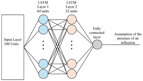
Figure 5.
LSTM model architecture.
During model training, the loss function and accuracy metric were monitored on the training and validation samples. After completing the training, the model was tested on the test sample: Accuracy = 0.79; Recall = 0.81; Precision = 0.84; F1-score = 0.83. This indicates that the model copes well with the task, correctly classifying most of the data. The model effectively identifies most of the real bends, which is critical for preventing errors in monitoring and maintaining the reliability of the railway roadbed.
4. Conclusions
This paper proposes a method for determining soil layer characteristics during drilling, distinguished using the phase of the resulting signal as a key informative parameter. The results of the studies showed that the proposed method has high sensitivity in the problem of determining the boundaries of soil layers.
The study results demonstrate that the proposed phase-metric method is highly sensitive in detecting transitions between soil layers, which is vital for maintaining railway track stability. Laboratory experiments confirmed that this method effectively monitors changes in the time series of signals, allowing for accurate identification of transitions between soil layers with varying characteristics. This capability is crucial for optimizing reinforcement strategies and preventing potential track failures. Although the method shows promise beyond railway infrastructure, including applications in environmental monitoring and construction, its primary value lies in enhancing the stability and safety of railway roadbeds. The method’s adaptability to various geological conditions and real-time requirements underscores its potential for widespread adoption in smart infrastructure systems. In addition, to improve the accuracy and efficiency of monitoring, a system based on recurrent neural networks, such as LSTM, has been developed and tested, which allows for the automatic detection of specific inflexions in time series. This not only improves the accuracy of layered structure analysis but also reduces the time and cost of monitoring and optimizing the condition of the railway roadbed.
The obtained results demonstrate the high efficiency of the developed LSTM model in the task of automatic detection of bends in a time series of phase signals. The model achieved 79% accuracy on the test set, which indicates its ability to correctly classify most events. Classification errors can be caused by noise in the data and the complex structure of phase signals. However, the accuracy can be increased in the future by increasing the size of the training set, applying regularization methods such as Dropout and L1/L2 regularization to prevent overfitting, and optimizing the model hyperparameters using automated search methods such as Grid Search or Bayesian Optimization.
The implementation of the developed system based on LSTM will make it possible to automate the process of analyzing geophysical data, reducing dependence on the human factor, reducing the time for detecting critical changes in the soil structure, and increasing the efficiency of monitoring. Additionally, integrating real-world data sets and conducting longitudinal studies will provide deeper insights into the method’s performance across diverse operational conditions. Since the studies were conducted under controlled laboratory conditions, which may not fully reflect the complexity and variability of real geological conditions, in the future, it is planned to place the research facility outdoors with a corresponding increase in scale.
The developed system can be integrated into existing infrastructure solutions, providing continuous monitoring and prompt responses to potentially dangerous changes in the soil under railway tracks.
Author Contributions
Conceptualization, A.B. and D.S.; methodology, A.B.; validation, A.B. and D.S.; formal analysis, A.B. and D.S.; investigation, L.K.; resources, A.A. and A.S.; data curation, K.I.; writing—original draft preparation, L.K. and K.I.; writing—review and editing, L.K. and A.S.; visualization, D.S.; supervision, A.B.; funding acquisition, D.S. All authors have read and agreed to the published version of the manuscript.
Funding
This study was supported by the Russian Science Foundation, grant No. 23-29-10126, https://rscf.ru/project/23-29-10126/ (accessed on 7 August 2024).
Institutional Review Board Statement
Not applicable.
Informed Consent Statement
Not applicable.
Data Availability Statement
The original contributions presented in this study are included in the article; further inquiries can be directed to the corresponding author.
Conflicts of Interest
The authors declare no conflicts of interest.
References
- Ngamkhanong, C.; Kaewunruen, S.; Costa, B.J.A. State-of-the-Art Review of Railway Track Resilience. Monitoring. Infrastruct. 2018, 3, 3. [Google Scholar] [CrossRef]
- Lazorenko, G.; Kasprzhitskii, A.; Khakiev, Z.; Yavna, V. Dynamic behavior and stability of soil foundation in heavy haul railway tracks: A review. Constr. Build. Mater. 2019, 205, 111–136. [Google Scholar] [CrossRef]
- Dell’Aversana, P. Integrated Geophysical Models: Combining Rock Physics with Seismic, Electromagnetic and Gravity Data; EAGE Publications: Utrecht, The Netherlands, 2014. [Google Scholar] [CrossRef][Green Version]
- Mensa-Wilmot, G. Drilling Efficiency and Rate of Penetration—Definitions, Influencing Factors, Relationships and Value. In Proceedings of the IADC/SPE Drilling Conference and Exhibition, New Orleans, LA, USA, 2 February 2010. [Google Scholar]
- Menand, S. Horizontal and Complex-Trajectory Wells. J. Pet. Technol. 2018, 70, 78. [Google Scholar] [CrossRef]
- Abzhanova, A.; Bykov, A.; Surzhik, D.; Mukhamejanova, A.; Orazbayev, B.; Svirina, A. Methods for Assessing the Layered Structure of the Geological Environment in the Drilling Process by Analyzing Recorded Phase Geoelectric Signals. Mathematics 2024, 12, 2194. [Google Scholar] [CrossRef]
- Cheverikin, A.V. Modern methods of monitoring geodynamic processes in oil and gas production areas, 21st century. Technosphere Saf. 2019, 1, 122–133. [Google Scholar] [CrossRef]
- Cherny, S.S. Problems of automation of the technological process of drilling oil and gas wells. Softw. Prod. Syst. 2015, 2, 113–118. [Google Scholar]
- Sousa, J.J.; Liu, G.; Fan, J.; Perski, Z.; Steger, S.; Bai, S.; Wei, L.; Salvi, S.; Wang, Q.; Tu, J.; et al. Geohazards Monitoring and Assessment Using Multi-Source Earth Observation Techniques. Remote Sens. 2021, 13, 4269. [Google Scholar] [CrossRef]
- Makulov, V.B. Vertical electrical sounding for solving geological problems. Symb. Sci. Russ. 2016, 13, 1–8. [Google Scholar]
- Chambers, J.; Kuras, O.; Meldrum, P.; Ogilvy, R.; Hollands, J. Electrical resistivity tomography applied to geologic, hydrogeologic, and engineering investigations at a former waste-disposal site. Geophysics 2006, 71, 231–239. [Google Scholar] [CrossRef]
- Sun, H.; Li, Z.; Hovakimyan, N.; Başsar, T.; Downton, G. Adaptive Control for Directional Drilling Systems. IFAC Proc. Vol. 2012, 45, 72–77. [Google Scholar] [CrossRef]
- Lech, M.; Skutnik, Z.; Bajda, M.; Markowska-Lech, K. Applications of Electrical Resistivity Surveys in Solving Selected Geotechnical and Environmental Problems. Appl. Sci. 2020, 10, 2263. [Google Scholar] [CrossRef]
- Kuzichkin, O.; Grecheneva, A.; Bykov, A.; Dorofeev, N.; Surzhik, D. Methods and algorithms of joint processing of geoelectric and seismoacoustic signals in real time. Int. Multidiscip. Sci. GeoConference SGEM 2018, 18, 877–884. [Google Scholar]
- Nybo, R. Efficient Drilling Problem Detection; Norwegian University of Science and Technology Press: Trondheim, Norway, 2009. [Google Scholar]
- Litvinenko, V.S.; Dvoynikov, M.V. Methodology for determining the parameters of drilling mode for directional straight sections of well using screw downhole motors. J. Min. Inst. 2020, 41, 105–112. [Google Scholar] [CrossRef]
- Bakuin, M.D.; Bykov, A.A.; Surzhik, D.I.; Kuzichkin, O.R. Geotechnical monitoring of the foundations of structures based on integrated seismoelectric measurements in conditions of karst hazard. Int. Multidiscip. Sci. GeoConference SGEM 2020, 20, 559–566. [Google Scholar]
- Bykov, A.; Grecheneva, A.; Kuzichkin, O.; Surzhik, D.; Vasilyev, G.; Yerbayev, Y. Mathematical Description and Laboratory Study of Electrophysical Methods of Localization of Geodeformational Changes during the Control of the Railway Roadbed. Mathematics 2021, 9, 3164. [Google Scholar] [CrossRef]
- Farhat, I.; Farrugia, L.; Bonello, J.; Sammut, C.; Persico, R. Measuring the Dielectric Properties of Soil: A Review and Some Innovative Proposals. In Instrumentation and Measurement Technologies for Water Cycle Management; Di Mauro, A., Scozzari, A., Soldovieri, F., Eds.; Springer Water: Cham, Switzerland, 2022. [Google Scholar] [CrossRef]
- Osipov, A.; Pleshakova, E.; Bykov, A.; Kuzichkin, O.; Surzhik, D.; Suvorov, S.; Gataullin, S. Machine Learning Methods Based on Geophysical Monitoring Data in Low Time Delay Mode for Drilling Optimization. IEEE Access 2023, 11, 60349–60364. [Google Scholar] [CrossRef]
- Chub, V.S. The use of recurrent neural networks to analyze time series and identify trends in data. Educ. Resour. Technol. 2024, 2, 91–102. [Google Scholar] [CrossRef]
Disclaimer/Publisher’s Note: The statements, opinions and data contained in all publications are solely those of the individual author(s) and contributor(s) and not of MDPI and/or the editor(s). MDPI and/or the editor(s) disclaim responsibility for any injury to people or property resulting from any ideas, methods, instructions or products referred to in the content. |
© 2024 by the authors. Licensee MDPI, Basel, Switzerland. This article is an open access article distributed under the terms and conditions of the Creative Commons Attribution (CC BY) license (https://creativecommons.org/licenses/by/4.0/).