
Characterization and Modernization of the Depositional System in Modern Ebinur Lake Basin, Northwest China


Abstract
1. Introduction
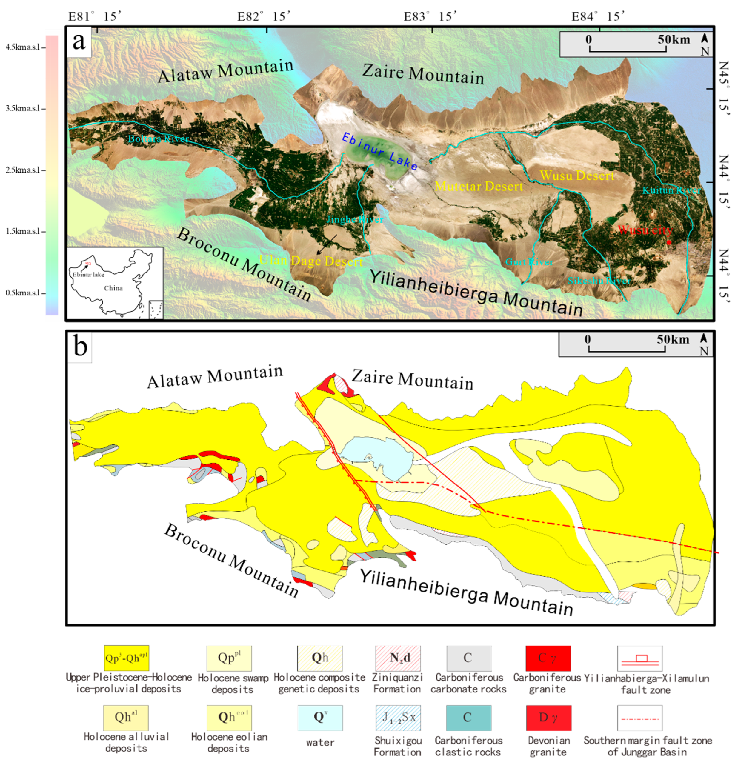
2. Study Area
3. Research Methods
3.1. Interpretation of Satellite Image
3.2. Field Sedimentary Investigation
4. Results
4.1. Types and Characteristics of Sedimentary Environment
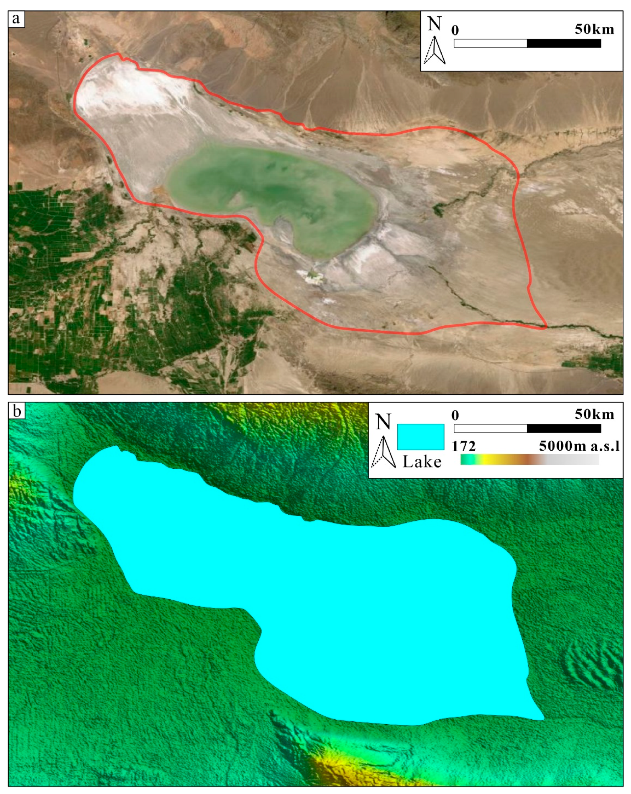
4.1.1. Lake Sedimentary Environment
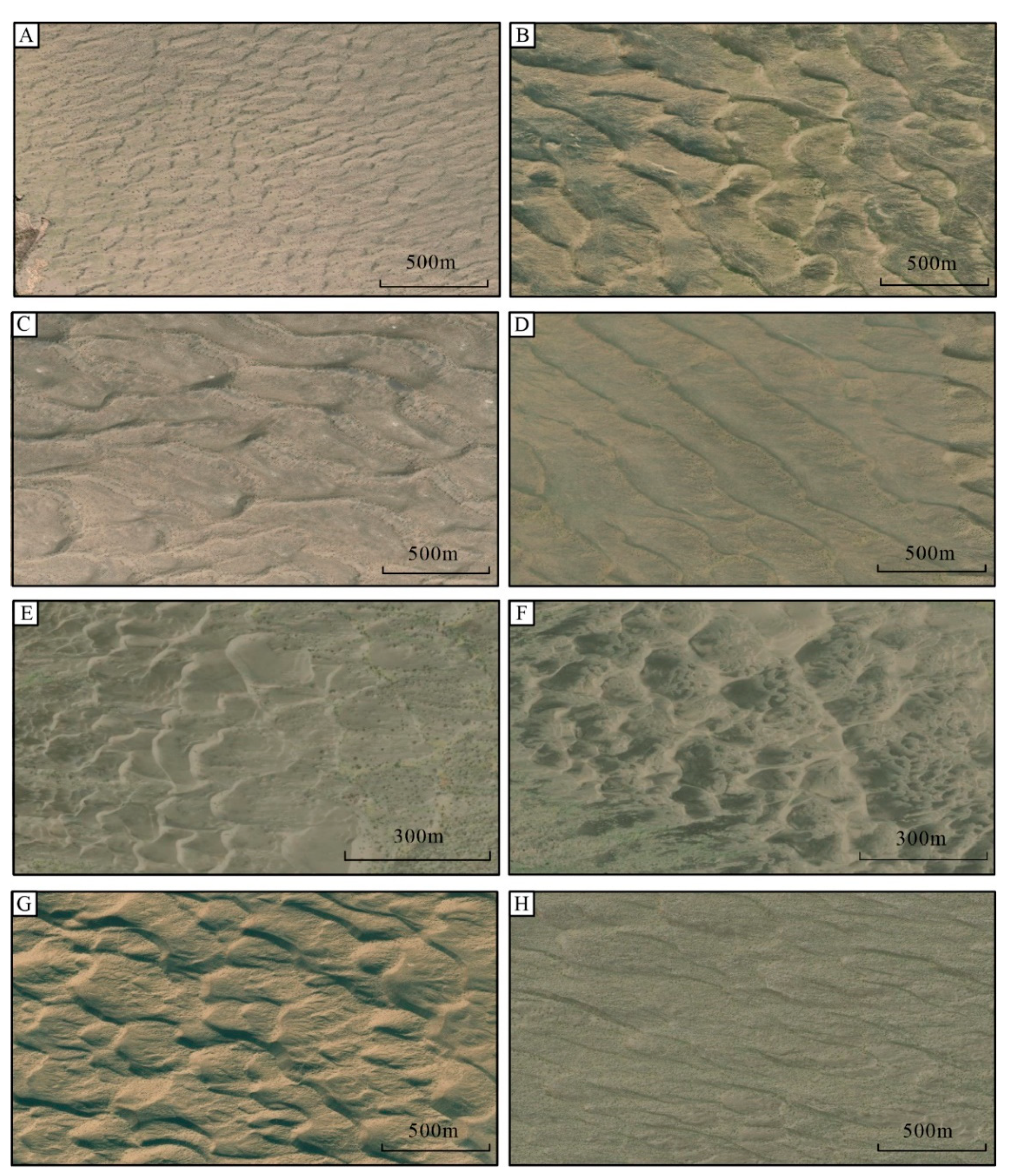
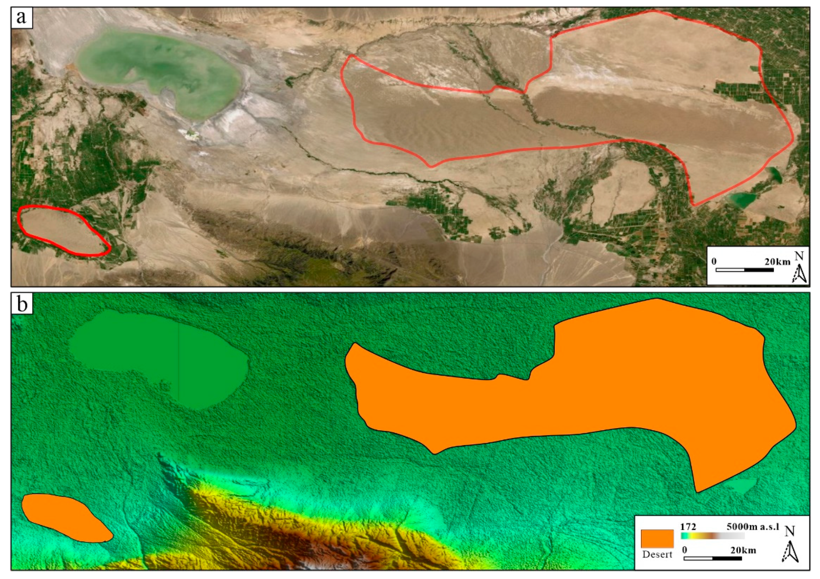
4.1.2. Desert Sedimentary Environment
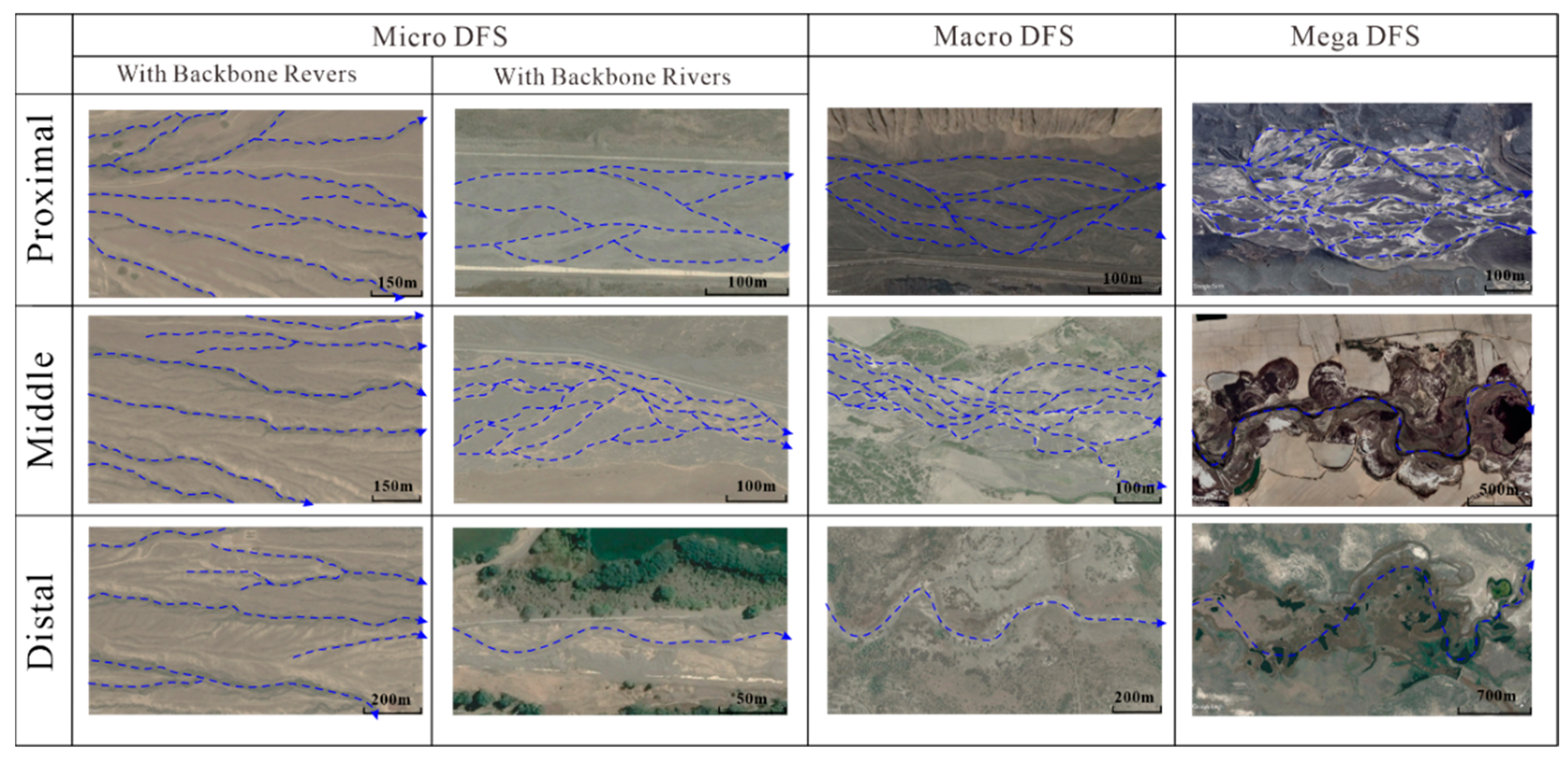
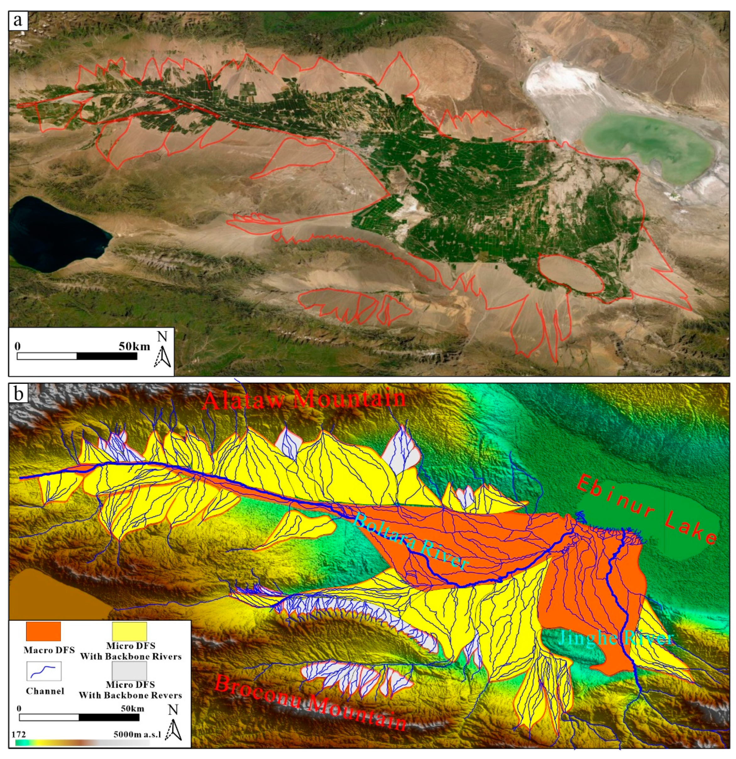
4.1.3. DFS Sedimentary Environment
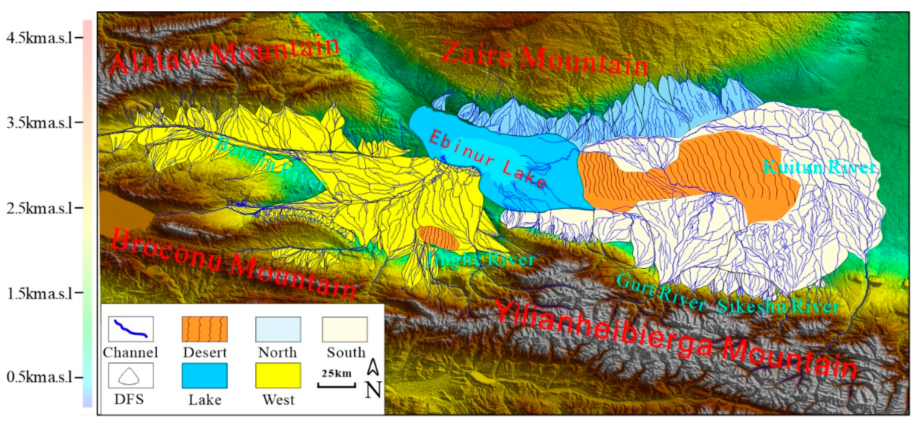
4.2. Sedimentary System Tract
4.2.1. Southern System Tract
4.2.2. Western System Tract
4.2.3. Northern System Tract
4.2.4. Desert System Tract
4.2.5. Lake System Tract
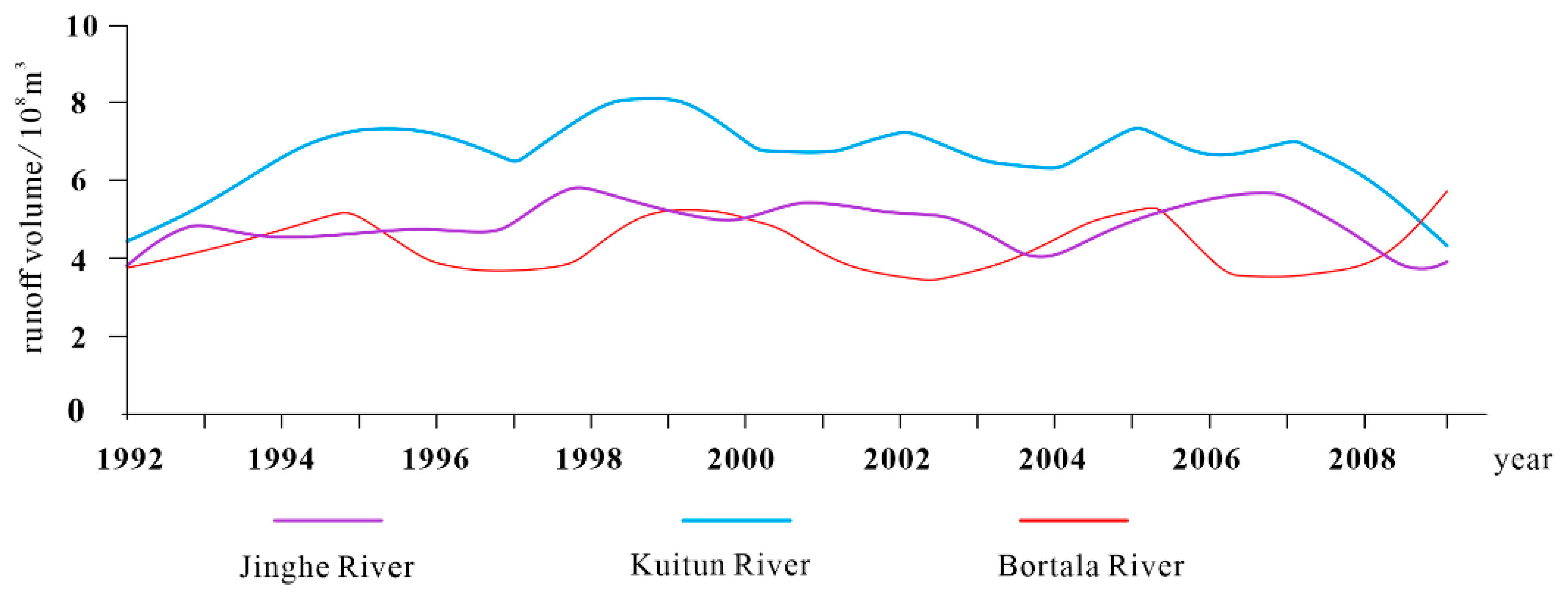
4.3. Deposition Distribution and Control Factors
4.3.1. Distribution and Controlling Factors of Sedimentary System Tracts
4.3.2. Distribution of Lake System and Its Controlling Factors
4.3.3. Distribution and Controlling Factors of Dune Sedimentary System
4.3.4. DFS System Distribution and Its Controlling Factors
5. Discussion
6. Conclusions
Author Contributions
Funding
Institutional Review Board Statement
Informed Consent Statement
Data Availability Statement
Conflicts of Interest
References
- Knebel, H.J. Modern sedimentary environments in a large tidal estuary, Delaware Bay. Mar. Geol. 1989, 86, 119–136. [Google Scholar] [CrossRef]
- Reddad, H.; El Talibi, H.; Perri, F.; El Moussaoui, S.; Zerdeb, M.A.; Zaghloul, M.N.; Critelli, S. Textural and compositional controls on modern fluvial and beach sands of Mediterranean coastal Rif belt (Northern Rif, Morocco). Ital. J. Geosci. 2016, 135, 336–349. [Google Scholar] [CrossRef]
- Szczuciński, W.; Jagodziński, R.; Hanebuth, T.J.; Stattegger, K.; Wetzel, A.; Mitręga, M.; Unverricht, D.; Van Phach, P. Modern sedimentation and sediment dispersal pattern on the continental shelf off the Mekong River delta, South China Sea. Glob. Planet. Chang. 2013, 110, 195–213. [Google Scholar] [CrossRef]
- Zhou, H.; Yuan, X.; Zhang, Y.; Dong, W.; Liu, S. Growth pattern research on the modern deposition of Ganjiang delta in Poyang lake basin by spatio-temporal remote sensing images. IOP Conf. 2016, 46, 012034. [Google Scholar] [CrossRef]
- Zhang, C.M.; Guo, X.G.; Liu, S.; Zhang, X.H.; Wang, X.L.; Guo, X.G.; Pan, J.; Hu, W.; Zhang, B.J.; Huang, R.X.; et al. Distribution of sedimentary environment and sedimentary system on the shore of modern Ulungu Lake and its controlling factors. Quat. Sci. 2020, 40, 49–68. [Google Scholar]
- Blair, T.C.; McPherson, J.G. Alluvial Fans and Their Natural Distinction from Rivers Based on Morphology, Hydraulic Processes, Sedimentary Processes, and Facies Assemblages. J. Sediment. Res. 1994, 64, 450–489. [Google Scholar]
- Jia, T.F.; Yin, S. Holocene geomorphological evolution in the northern Ulan Buh Desert. Geogr. Sci. 2004, 2, 217–221. [Google Scholar]
- Wang, M.; Gao, X.; Qu, X.; Zhang, S.; Zhang, Y.; Chen, G.; Li, J. Morphological characteristics of dunes in the piedmont dunes of the southwestern margin of the Qaidam Basin. China Desert 2021, 41, 166–174. [Google Scholar]
- Changmin, Z.; Xinmin, S.; Dongming, Z.; Xinhuai, Z.; Taiju, Y.; Yanshu, Y.; Rui, Z.; Wenjie, F.; Baojin, Z. Rethinking on the sedimentary system of terrestrial petroliferous basins: Insights from distributive fluvial system. Acta Pet. Sin. 2020, 41, 127–153. [Google Scholar]
- Brown, L.F.; Fisher, W. Seismic-Stratigraphic Interpretation of Depositional Systems: Examples from Brazilian Rift and Pull-Apart Basins: Section 2. In Application of Seismic Reflection Configureuration to Stratigraphic Interpretation; Datapages Inc.: Rockaway, NJ, USA, 1977. [Google Scholar]
- Vail, P.R. Seismic stratigraphy and global changes of sea level. Mem. Am. Assoc. Pet. Geol. 1977, 26, 49–50. [Google Scholar]
- Posamentier, H.W.; Allen, G.P.; James, D.P.; Tesson, M. Forced regressions in a sequence stratigraphic framework: Concepts, examples, and exploration significance. AAPG Bull. 1992, 76, 1687–1709. [Google Scholar]
- Hunt, D.; Tucker, M.E. Stranded parasequences and the forced regressive wedge systems tract: Deposition during base-level fall. Sediment. Geol. 1992, 81, 219–230. [Google Scholar] [CrossRef]
- Helland-Hansen, W.; Gjelberg, J.G. Conceptual basis and variability in sequence stratigraphy: A different perspective. Sediment. Geol. 1994, 92, 31–52. [Google Scholar] [CrossRef]
- Catuneanu, O. Principles of Sequence Stratigraphy; Elsevier: Amsterdam, The Netherlands, 2007. [Google Scholar]
- Feng, Y.L.; Li, S.T.; Xie, X.N. Dynamics of sequence generation and sequence stratigraphic model in continental rift subsidence basin. Geol. Front. 2000, 3, 119–132. [Google Scholar]
- Wu, Y.; Zhang, T.; Zhang, Z.; Cui, H. Types and characteristics of depositional systems tract and its petroleum geological significance. J. Palaeogeogr. 2010, 12, 69–81. [Google Scholar]
- Mei, M.X.; Su, D.C. Sequence-Stratigraphic Succession for the Course Clastic Rock System of the Hekou Group in the Gulang County of Gansu Province: Sedimentological Response to Cretaceous Uplift of the Qilian Mountains. Geol. Rev. 2014, 60, 541–554. [Google Scholar]
- Weissmann, G.; Hartley, A.; Nichols, G.; Scuderi, L.; Olson, M.; Buehler, H.; Banteah, R. Fluvial form in modern continental sedimentary basins: Distributive fluvial systems. Geology 2010, 38, 39–42. [Google Scholar] [CrossRef]
- Hartley, A.J.; Weissmann, G.S.; Nichols, G.J.; Warwick, G.L. Large Distributive Fluvial Systems: Characteristics, Distribution, and Controls on Development. J. Sediment. Res. 2016, 80, 167–183. [Google Scholar] [CrossRef]
- Assine, M.L.; Merino, E.R.; Pupim, F.D.N.; Macedo, H.d.A.; dos Santos, M.G.M. The Quaternary alluvial systems tract of the Pantanal Basin, Brazil. Braz. J. Geol. 2017, 45, 475–489. [Google Scholar] [CrossRef]
- Cavazza, D.C. A comparison of fluvial megafans in the Cordilleran (Upper Cretaceous) and modern Himalayan foreland basin systems. GSA Bull. 1999, 111, 1315–1334. [Google Scholar]
- Fontana, A.; Mozzi, P.; Marchetti, M. Alluvial fans and megafans along the southern side of the Alps. Sediment. Geol. 2014, 301, 150–171. [Google Scholar] [CrossRef]
- Yan, S.; Mu, G.J.; Nobuhiko, H.; Masao, U.; Naomi, H. Environmental Evolution Information from Aiby Lake since the Last 2500a. Arid. Land Geogr. 2003, 26, 227–231. [Google Scholar]
- Yan, S. Environmental evolution and countermeasures in Ebinur Lake and its surrounding areas. J. Arid. Land Resour. Environ. 1996, 1, 30–37. [Google Scholar]
- Bo, C.G.; Mu, G.J. The lakeshore landform of Ebinur Lake and its reflected lake surface change. Arid. Land Geogr. 1999, 34–40. [Google Scholar]
- Ding, J.L.; Ge, X.Y.; Wang, J.Z. Ebinur Lake wetland identification and its spatio-temporal dynamic changes. J. Nat. Resour. 2021, 36, 1949–1963. [Google Scholar] [CrossRef]
- Amantai, N.; Ding, J.; Ge, X.; Bao, Q. Variation characteristics of actual evapotranspiration and meteorological elements in the Ebinur Lake basin from 1960 to 2017. Acta Geogr. Sin. 2021, 76, 1177–1192. [Google Scholar]
- Lawton, T.F.; Schellenbach, W.L.; Nugent, A.E. Late Cretaceous Fluvial-Megafan and Axial-River Systems in the Southern Cordilleran Foreland Basin: Drip Tank Member of Straight Cliffs Formation and Adjacent Strata, Southern Utah, U.S.A. J. Sediment. Res. 2014, 84, 407–434. [Google Scholar] [CrossRef]
- Gulliford, A.R.; Flint, S.S.; Hodgson, D.M. Crevasse splay processes and deposits in an ancient distributive fluvial system: The lower Beaufort Group, South Africa. Sediment. Geol. 2017, 358, 1–18. [Google Scholar] [CrossRef]
- Wu, Z. Discussion on the Causes of Taklimakan Desert. Acta Geogr. Sin. 1981, 280–291. [Google Scholar]
- Zhang, C.; Zhang, X.; Hartley, A. On classification of distributive fluvial system. Lithol. Reserv. 2023, 35, 1–15. [Google Scholar]
- Bilmes, A.; Veiga, G.D. Linking mid-scale distributive fluvial systems to drainage basin area: Geomorphological and sedimentological evidence from the endorheic Gastre Basin, Argentina. Geol. Soc. Lond. Spec. Publ. 2016, 440, 265–279. [Google Scholar] [CrossRef]
- Yao, Y.; Mei, C.J. The composition of “unconventional” system tracts within the continental sequence: An important advancement on sequence stratigraphy. J. Palaeogeogr. 2017, 19, 513–524. [Google Scholar]
- Lei, M.; Zhou, J.L.; Zhang, J.; Chen, Y.P.; Teng, J.; Wu, T.; Xu, D.S.; Ji, Y.Y. Hydrochemical characteristics and transformation relationship of surface water and groundwater in the Plain Area of Bortala River Basin, Xinjiang. Environ. Sci. 2022, 43, 1873–1884. [Google Scholar]
- Shen, R.X.; Lv, S.P.; Du, M.L. Analysis of groundwater resources evolution in the plains of Kuytun River Basin. Arid. Zone Res. 2020, 37, 839–846. [Google Scholar]
- Dong, Y.; Zhang, L.S.; Chen, X.G. Runoff characteristic and its responses to precipitation change in Jinghe River. South-to-North Water Transf. Water Sci. Technol. 2016, 14, 60–64+98. [Google Scholar]
- Aji, D.N.; Kondo, H.; Aji, S. Climatic Change in the Bortala River Basin and Runoff Volume. Resour. Sci. 2014, 36, 2123–2130. [Google Scholar]


| Morphological Type | Wave Length (m) | Wave Width (m) | Wave Height (m) |
|---|---|---|---|
| Minimum value | 45 | 63 | 1 |
| Maximum value | 738 | 922 | 54 |
| Average value | 199 | 289 | 10 |
| Morphological Type | Radius (km) | Area (km2) | Gradient (°) |
|---|---|---|---|
| Minimum value | 1.44 | 0.45 | 0.18 |
| Maximum value | 144 | 2731 | 7.5 |
| Average value | 12.28 | 122 | 5.4 |
| Sedimentary Systems | Gross Area | Proportion of the Study Area |
|---|---|---|
| lake | 1906 | 8.56% |
| Dune | 1663 | 7.56% |
| DFS | 18435 | 83.78% |
Disclaimer/Publisher’s Note: The statements, opinions and data contained in all publications are solely those of the individual author(s) and contributor(s) and not of MDPI and/or the editor(s). MDPI and/or the editor(s) disclaim responsibility for any injury to people or property resulting from any ideas, methods, instructions or products referred to in the content. |
© 2024 by the authors. Licensee MDPI, Basel, Switzerland. This article is an open access article distributed under the terms and conditions of the Creative Commons Attribution (CC BY) license (https://creativecommons.org/licenses/by/4.0/).
Share and Cite
Xiang, J.; Zhang, X.; Liu, J.; Meng, Q.; Zhang, Y.; Li, X. Characterization and Modernization of the Depositional System in Modern Ebinur Lake Basin, Northwest China. Appl. Sci. 2024, 14, 4425. https://doi.org/10.3390/app14114425
Xiang J, Zhang X, Liu J, Meng Q, Zhang Y, Li X. Characterization and Modernization of the Depositional System in Modern Ebinur Lake Basin, Northwest China. Applied Sciences. 2024; 14(11):4425. https://doi.org/10.3390/app14114425
Chicago/Turabian StyleXiang, Jianbo, Xianghui Zhang, Jiale Liu, Qinghao Meng, Yu Zhang, and Xinglu Li. 2024. "Characterization and Modernization of the Depositional System in Modern Ebinur Lake Basin, Northwest China" Applied Sciences 14, no. 11: 4425. https://doi.org/10.3390/app14114425
APA StyleXiang, J., Zhang, X., Liu, J., Meng, Q., Zhang, Y., & Li, X. (2024). Characterization and Modernization of the Depositional System in Modern Ebinur Lake Basin, Northwest China. Applied Sciences, 14(11), 4425. https://doi.org/10.3390/app14114425