
Geo-Environment Suitability Evaluation for Urban Construction in Rongcheng District of Xiong’an New Area, China

Abstract
:1. Introduction
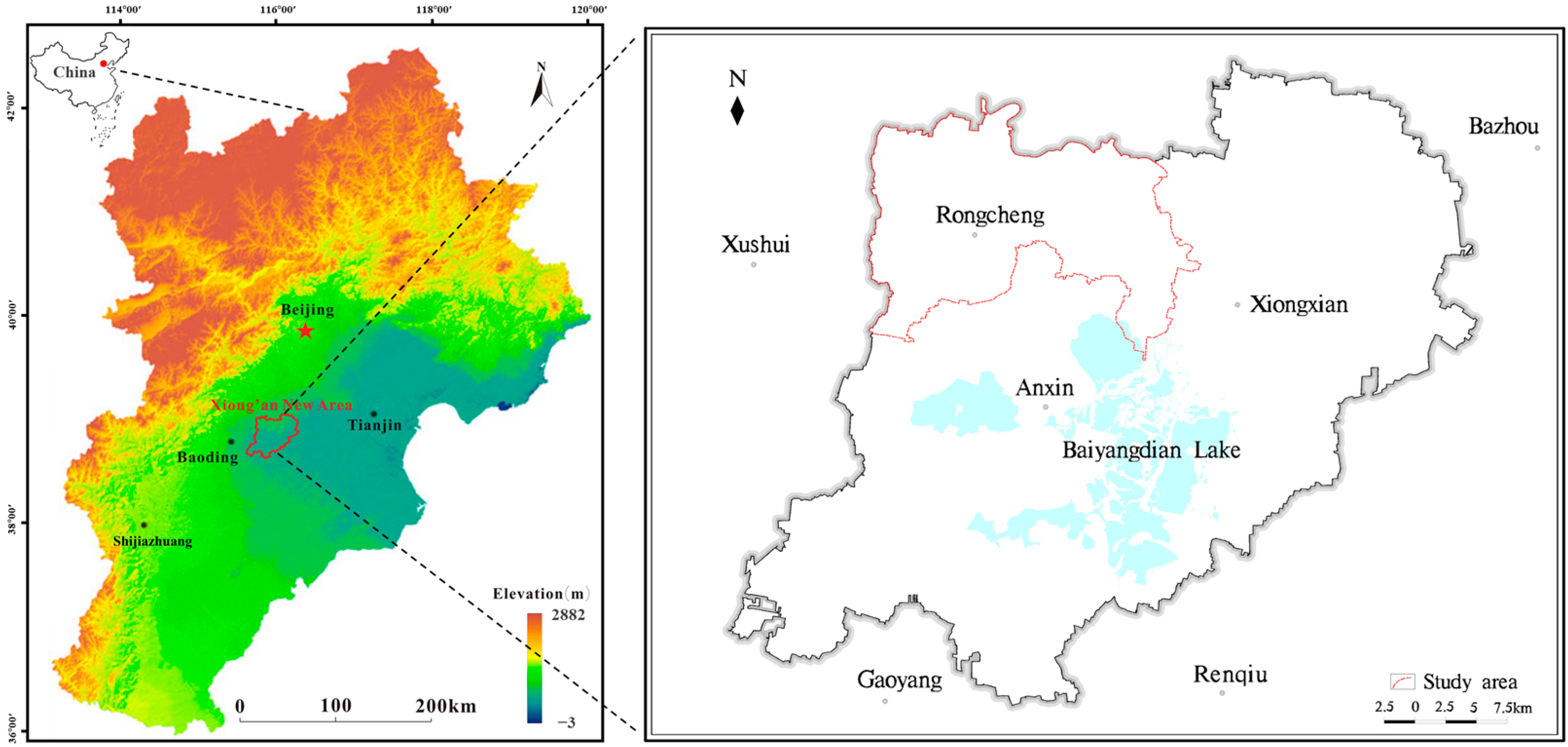
2. Study Area
3. Methods
3.1. Field Survey and Data Collection
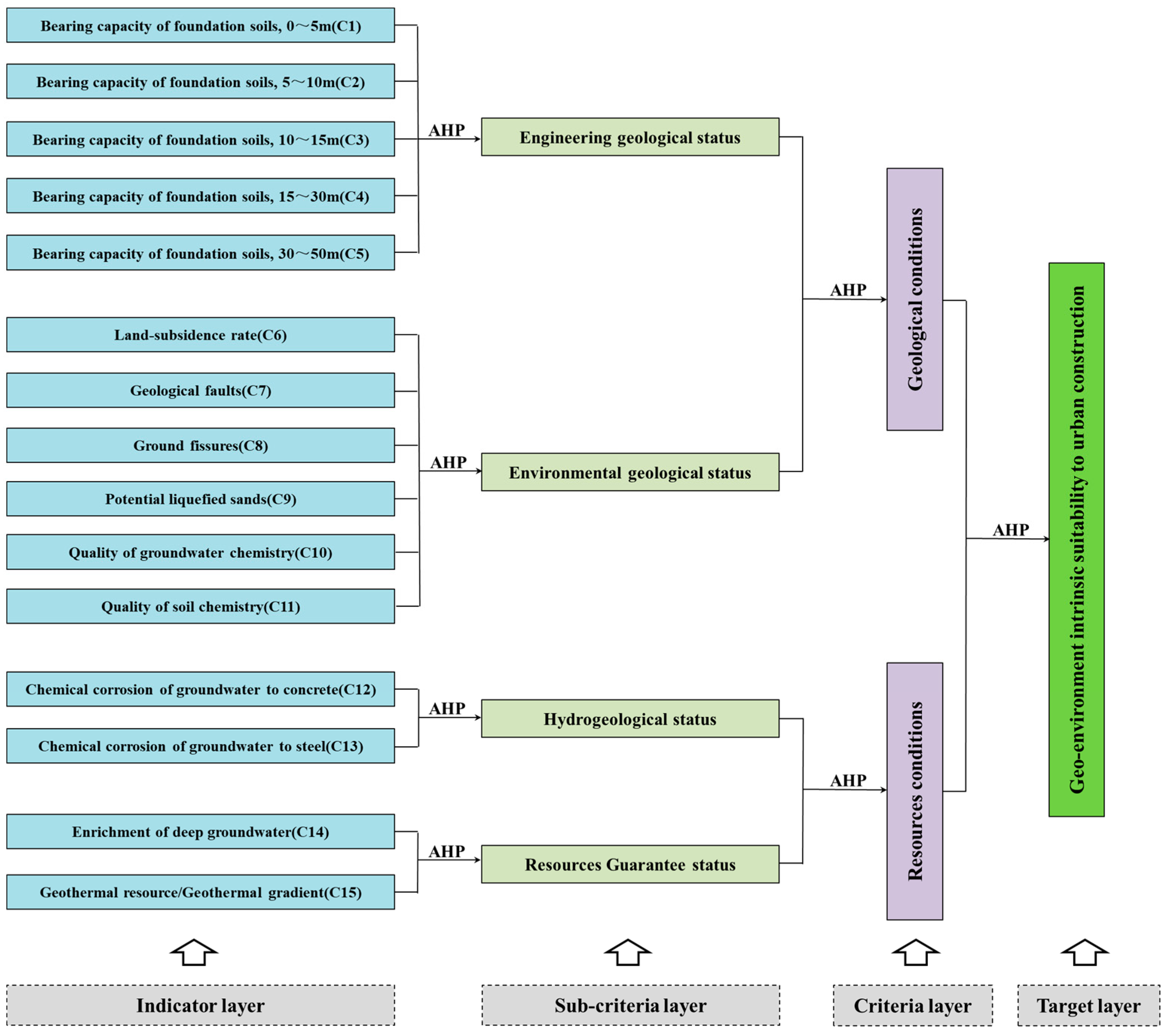
3.2. Comprehensive Evaluation Frame
3.3. Evaluation Method
- (1)
- Establish an importance matrix, A.
- (2)
- Identify the weights
- (3)
- Calculate the suitability comprehensive index, SI.
4. Results and Discussion
4.1. Results and Discussion of Geo-Environment Indicator Distribution
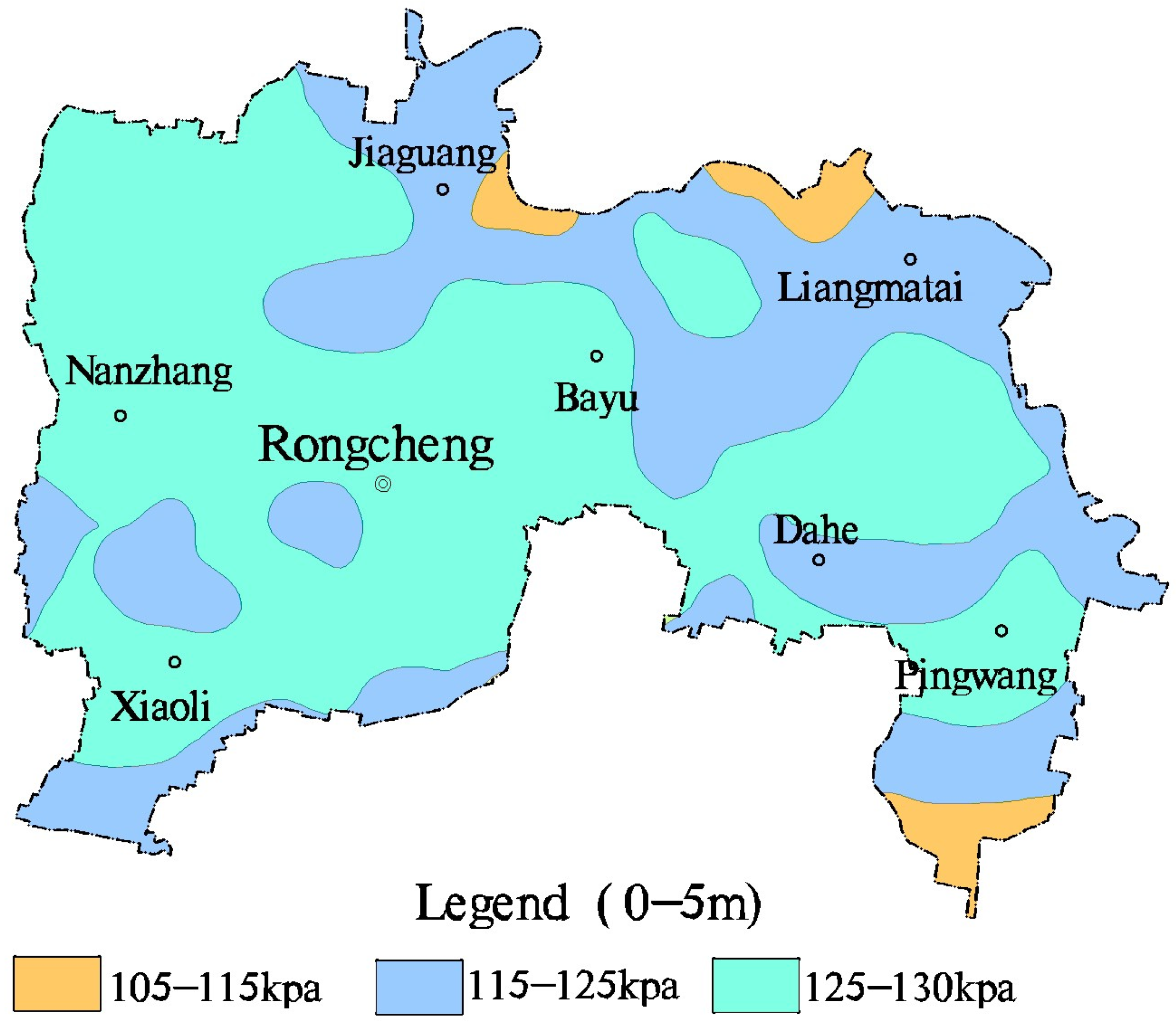
4.1.1. Bearing Capacity of Foundation Soils
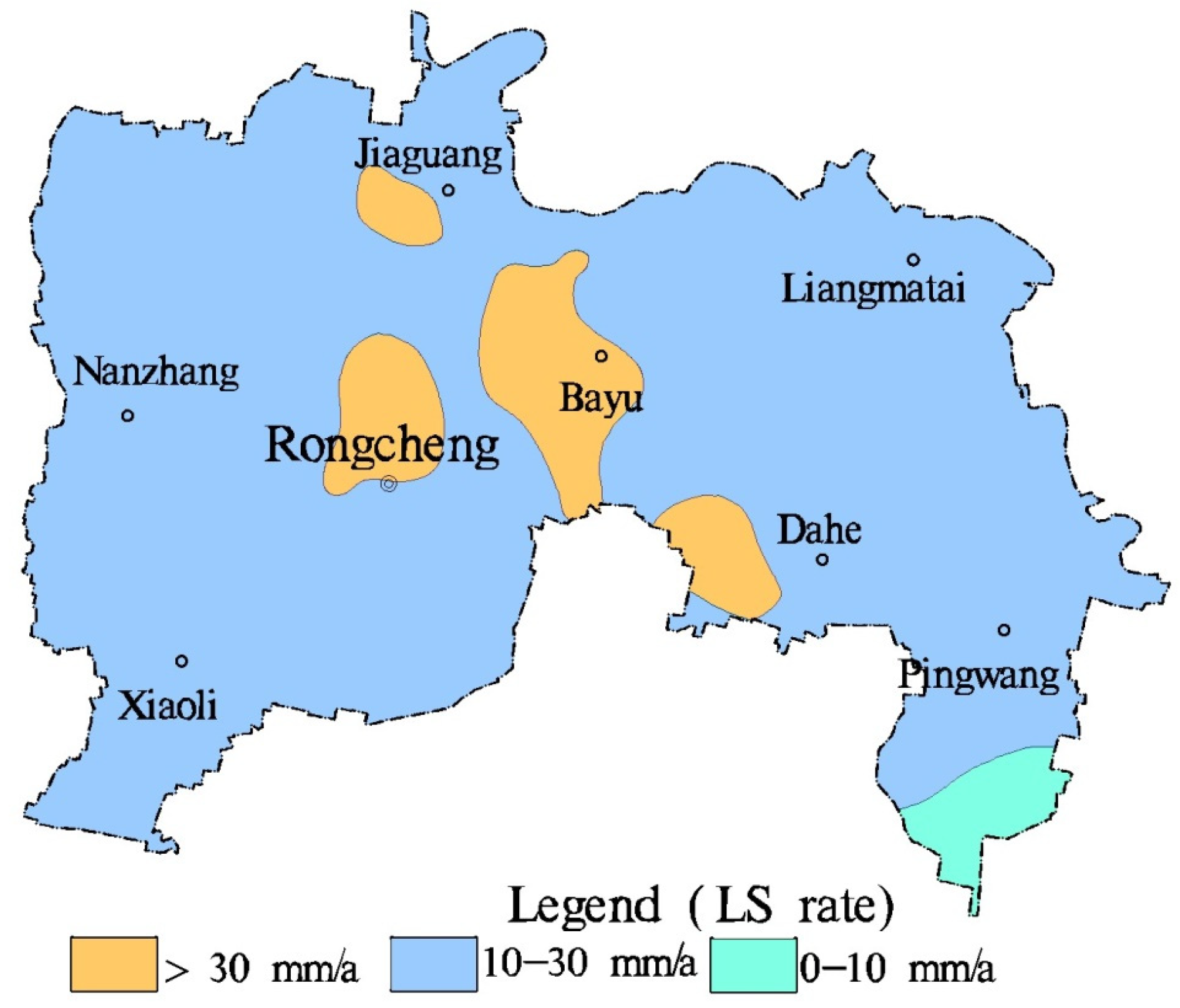
4.1.2. Land Subsidence
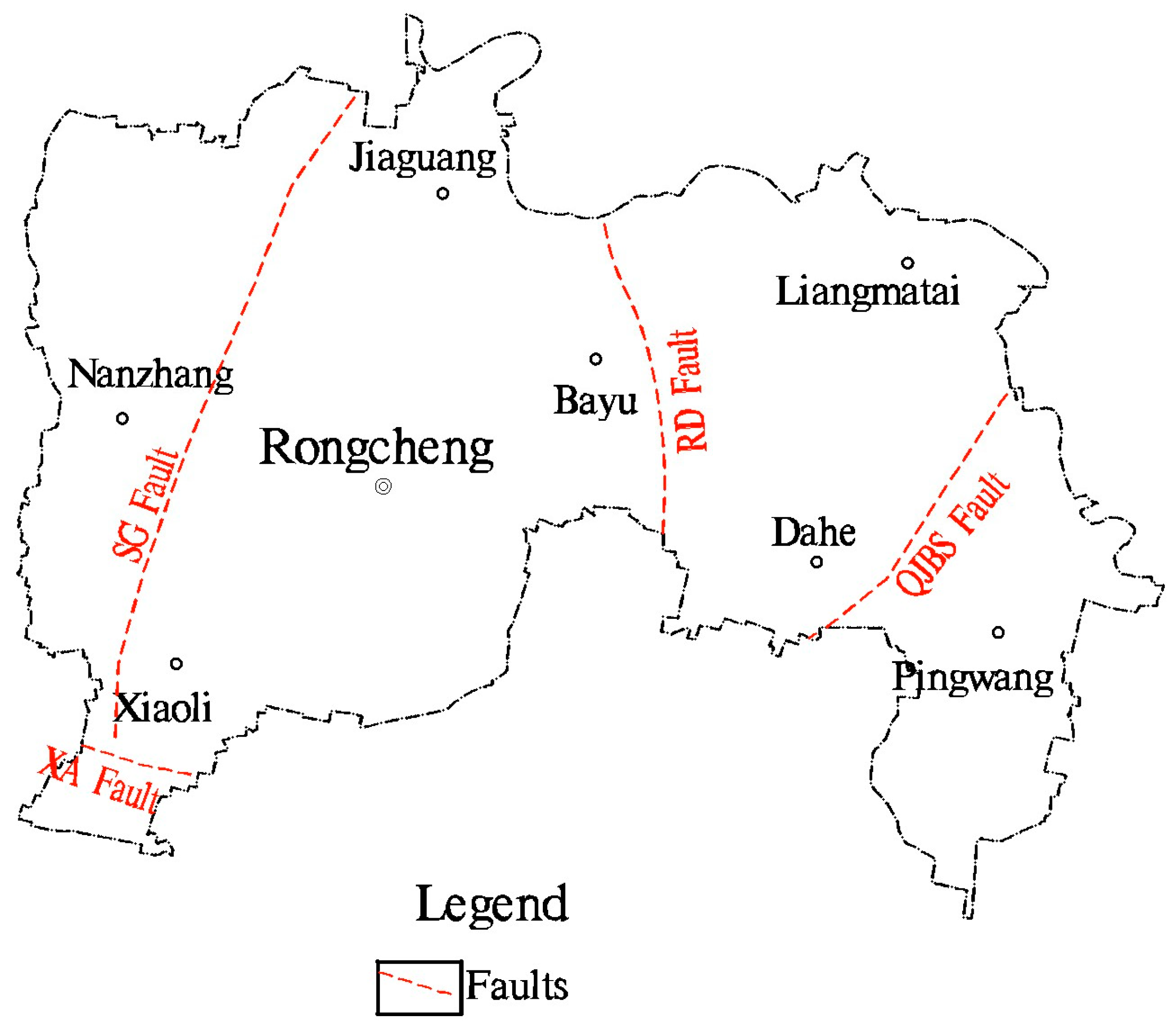
4.1.3. Geological Faults
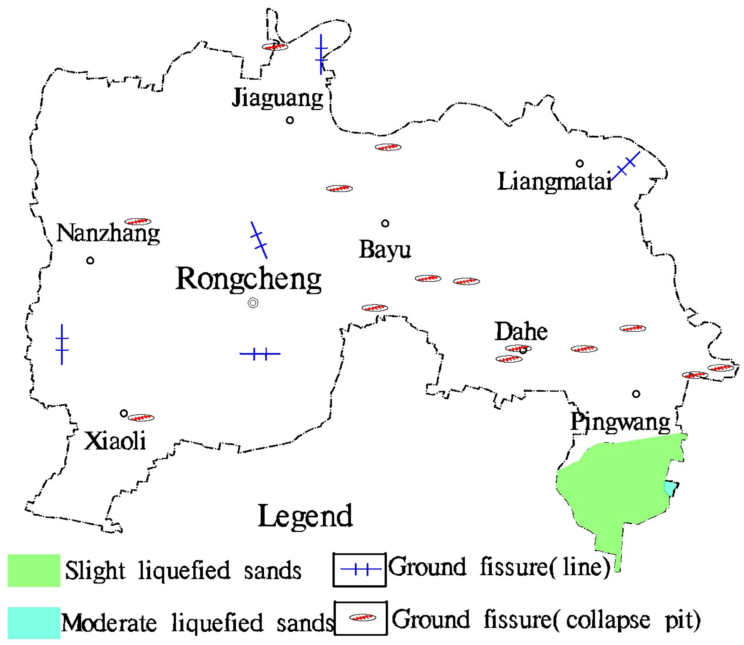
4.1.4. Ground Fissures
4.1.5. Potential Liquefied Sands
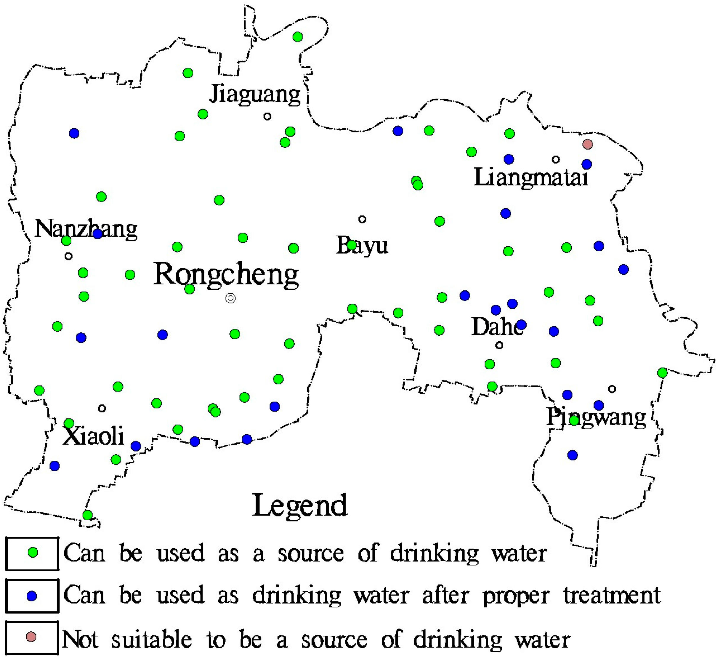
4.1.6. Qualities of Groundwater and Soil Chemistry
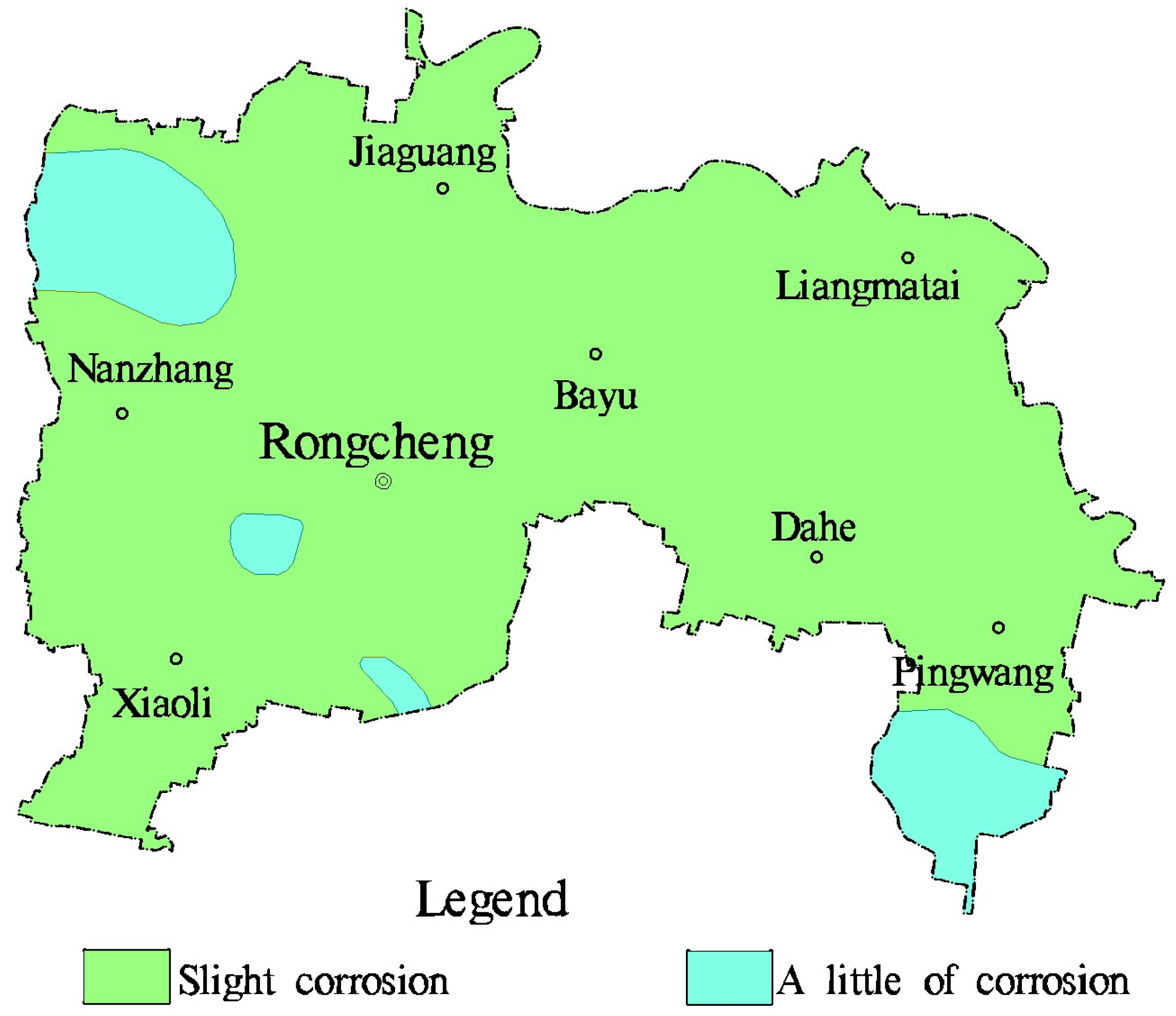
4.1.7. Chemical Corrosion of Concrete and Steel by Groundwater
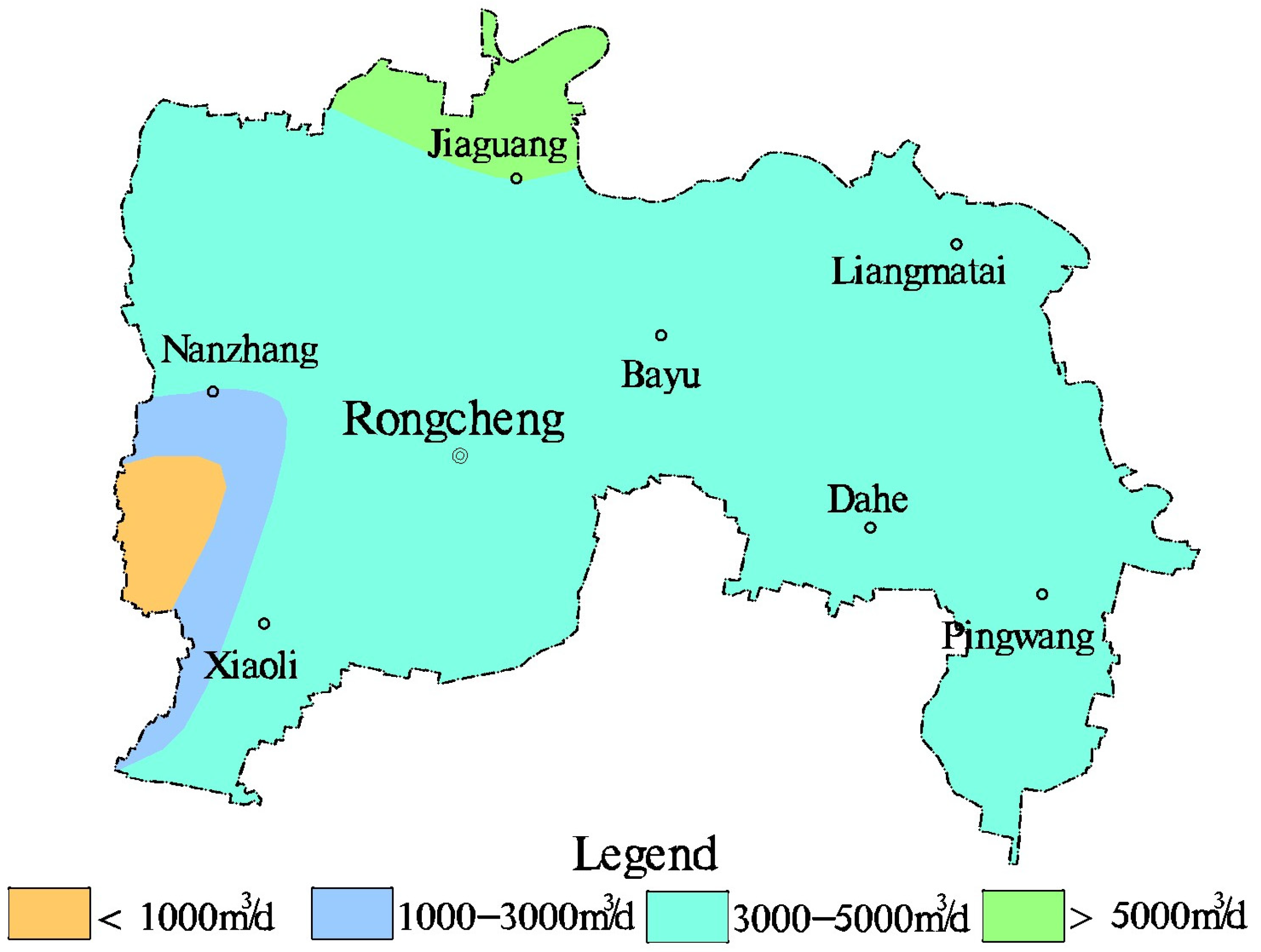
4.1.8. Enrichment of Deep Groundwater and Geothermal Resource
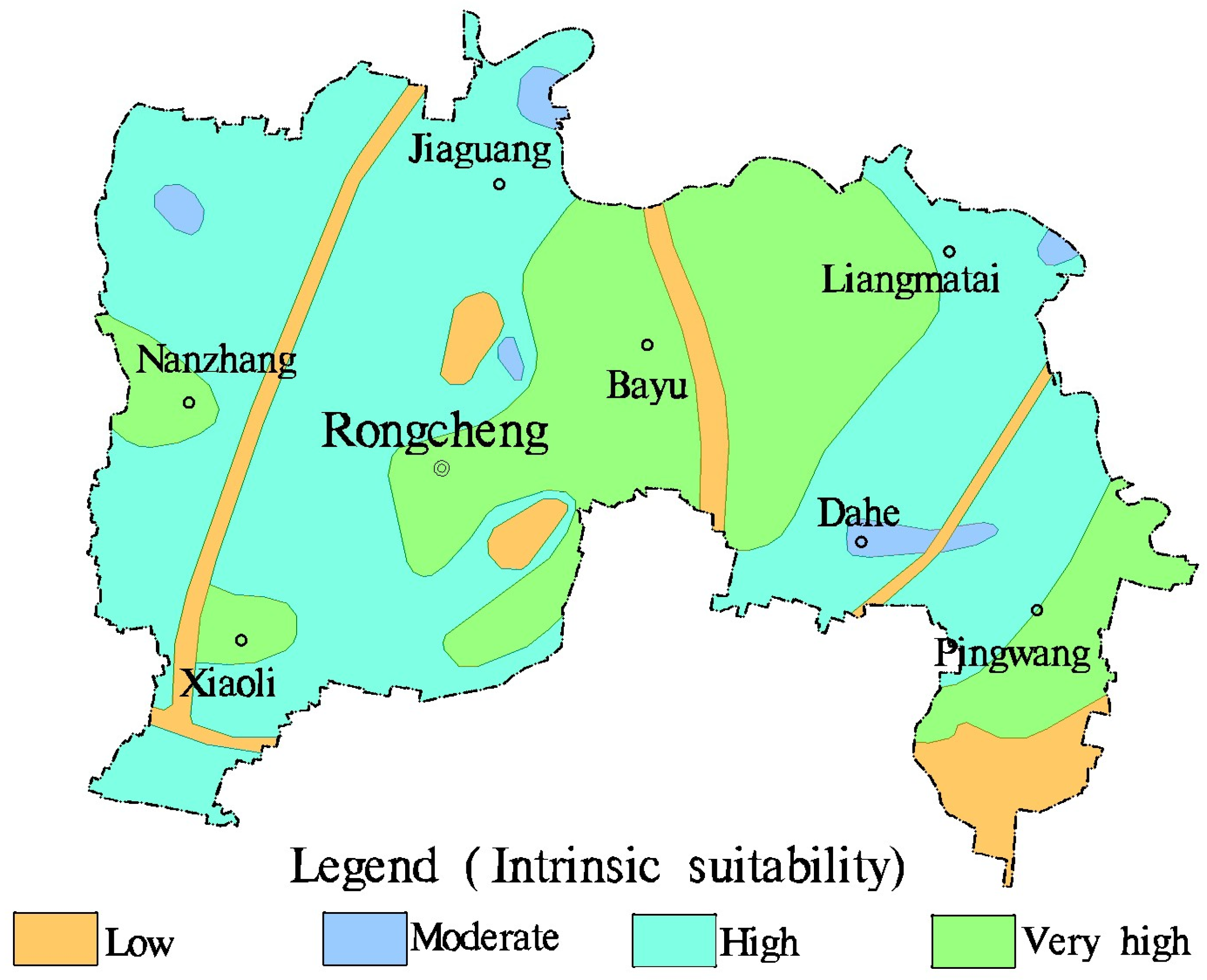
4.2. Results and Discussion of Geo-Environment Suitability for Urban Construction
5. Conclusions
- (1)
- In order to evaluate the geo-environment suitability for urban construction in Rongcheng district of Xiong’an New Area, the analytic hierarchy process (AHP) integrated GIS overlay analysis was used, based on the construction of a comprehensive evaluation frame. Moreover, two criteria, consisting of geological conditions and resource conditions, were taken into consideration for suitability evaluation, including four subcriteria, i.e., engineering geological status, environmental geological status, hydrogeological status, and resource guarantee status, which involved 15 indicators. Regrettably, the evaluation did not include the compressibility indicator of foundation soils due to a lack of data. When evaluating the suitability of the geo-environment for urban construction in other areas with the AHP method, more indicators of foundation soils could be taken into consideration. Furthermore, the analytic hierarchy process has certain advantages compared to other methods, such as the artificial neural network method and grey comprehensive evaluation method. It not only provides a quantitative mathematical calculation, but also incorporates the comparative judgment of geological experts regarding the importance of different geological indicators.
- (2)
- The evaluation results showed that the geo-environment suitability for urban construction in most areas was in high and very high grades, of which, the very high zone covered an area of about 98 km2, and the high zone was nearly 182 km2. The acreage of the moderate grade was approximately 5.5 km2, and the low grade was close to 28.5 km2. The most suitable areas for urban construction, with an acreage percentage of 31.2%, were mainly located in the central parts of the study area. In the meantime, the least suitable areas, with an acreage percentage of 9.1%, were situated in the southeast corner and three linear belts.
- (3)
- It is crucial to emphasize that faults, land subsidence rate, and potential liquefied sands are the primary factors that influence decision-making regarding future construction activities. When urban construction takes place in areas close to faults, buildings should maintain a certain distance from them, and these areas should be designated as green spaces. In regions experiencing a land subsidence rate of more than 30 mm/a, it is advisable to reduce groundwater extraction and lower the height of planned buildings. Additionally, engineering protection measures should be implemented in areas with potential liquefied sands. By addressing these issues, the study area can reduce infrastructure construction costs, and minimize the risk of geological disasters.
Author Contributions
Funding
Institutional Review Board Statement
Informed Consent Statement
Data Availability Statement
Conflicts of Interest
References
- Xu, K.; Kong, C.F.; Li, J.F.; Zhang, L.; Wu, C. Suitability evaluation of urban construction land based on geo-environmental factors of Hangzhou, China. Comput. Geosci. 2011, 37, 992–1002. [Google Scholar] [CrossRef]
- Zhou, X.N.; Wang, Z.X.; Miao, Q.Z.; Zhang, B. Study the shallow groundwater chemical characteristics in the typical area of Zhanghe catchment basin. Geol. Surv. Res. 2020, 43, 265–270. [Google Scholar]
- Tann, L.; Ritter, S.; Hale, S.; Langford, J.; Salazar, S. From urban underground space (UUS) to sustainable underground urbanism (SUU): Shifting the focus in urban underground scholarship. Land Use Policy 2021, 109, 105650. [Google Scholar] [CrossRef]
- Svoray, T.; Bar, P.; Bannet, T. Urban land-use allocation in a Mediterranean ecotone: Habitat heterogeneity model incorporated in a GIS using a multi-criteria mechanism. Landsc. Urban Plan. 2005, 72, 337–351. [Google Scholar] [CrossRef]
- Liu, H.; Chen, F.C.; Chen, G. Fuzzy evaluation of construction land suitability based on the geological environment. Resour. Environ. Eng. 2016, 30, 645–653. [Google Scholar]
- Dou, F.; Xing, H.; Li, X.; Yuan, F.; Lu, Z.; Li, X.; Ge, W. 3D Geological suitability evaluation for urban underground space development based on combined weighting and improved TOPSIS. Nat. Resour. Res. 2022, 31, 693–711. [Google Scholar] [CrossRef]
- Feick, R.; Hall, B. A method for examining the spatial dimension of multi-criteria weight sensitivity. Int. J. Geogr. Inf. Sci. 2004, 18, 815–840. [Google Scholar] [CrossRef]
- Ananda, J.; Herath, G. A critical review of multi-criteria decision making methods with special reference to forest management and planning. Ecol. Econ. 2009, 68, 2535–2548. [Google Scholar] [CrossRef]
- Mosadeghi, R.; Warnken, J.; Tomlinson, R.; Mirfenderesk, H. Comparison of fuzzy-AHP and AHP in a spatial multi-criteria decision making model for urban land-use planning. Comput. Environ. Urban Syst. 2015, 49, 54–65. [Google Scholar] [CrossRef]
- Romano, G.; Dal Sasso, P.; Trisorio Liuzzi, G.; Gentile, F. Multi-criteri decision analysis for land suitability mapping in a rural area of Southern Italy. Land Use Policy 2015, 48, 131–143. [Google Scholar] [CrossRef]
- Ustaoglua, E.; Aydınoglu, A.C. Suitability evaluation of urban construction land in Pendik district of Istanbul, Turkey. Land Use Policy 2020, 99, 104783. [Google Scholar] [CrossRef]
- Zhang, J.; Su, Y.; Wu, J.; Liang, H. GIS based land suitability assessment for tobacco production using AHP and fuzzy set in shandong province of China. Comput. Electron. Agric. 2015, 114, 202–211. [Google Scholar] [CrossRef]
- Youssef, A.M.; Pradhan, B.; Tarabees, E. Integrated evaluation of urban development suitability based on remote sensing and GIS techniques: Contribution from the analytic hierarchy process. Arab. J. Geosci. 2011, 4, 463–473. [Google Scholar] [CrossRef]
- Durmisevic, S.; Sariyildiz, S. A systematic quality assessment of underground spaces–public transport stations. Cities 2001, 18, 13–23. [Google Scholar] [CrossRef]
- Duan, Y.; Xie, Z.; Zhao, F.; Zeng, H.; Lin, M.; Chen, H.; Hou, Z. Suitability of underground space development in plateau cities based on geological environment analysis: Case study in Kunming, China. J. Urban Plan. Dev. 2021, 147, 05021014. [Google Scholar] [CrossRef]
- Xu, G.; Yang, Y.P.; Lu, S.Y.; Li, L.; Song, X. Comprehensive evaluation of coal-fired power plants based on grey relational analysis and analytic hierarchy process. Energy Policy 2011, 39, 2343–2351. [Google Scholar] [CrossRef]
- Costa, A.N.; Polivanov, H.; Alves, M.G.; Ramos, D.P. Multicriterial analysis in the investigation of favorable areas for edifications with shallow and deep foundations in the Municipality of Campos dos Goytacazes-Rio de Janeiro, Brazil. Eng. Geol. 2011, 123, 149–165. [Google Scholar] [CrossRef]
- Mejía-Navarro, M.; Wohl, E.E.; Oaks, S.D. Geological hazards vulnerability and risk assessment using GIS: Model for Glenwood Springs, Colorado. Geomorphology 1994, 10, 331–354. [Google Scholar] [CrossRef]
- Mejía-Navarro, M.; Garcia, L.A. Natural hazard and risk assessment using decision support systems, application: Glenwood Springs, Colorado. Environ. Eng. Geosci. 1996, 2, 299–324. [Google Scholar] [CrossRef]
- Shan, M.; Hadidi, M.; Vessali, E. Intelating multcriteria decision analysis for a GIS-based hazardous waste landfill sitting in Kurdistan Province, western Iran. Waste Manag. 2009, 29, 2740–2758. [Google Scholar]
- Liu, H.; Cao, H.; Fu, Y. Fuzzy comprehensive evaluation of adaptability of natural foundation in a city. Eng. Technol. 2016, 7, 269–270. [Google Scholar]
- Wang, W.T.; Guo, M.W. Engineering geological zoning and suitability evaluation of engineering construction in Shangqiu planning area. Miner. Explor. 2022, 13, 130–138. [Google Scholar]
- Hu, X.J.; Gao, L.; Ma, C.M.; Hu, X.J. Land use zoning of Weifang North Plain based on ecological function and geo-environmental suitability. Bull. Eng. Geol. Environ. 2020, 79, 2697–2719. [Google Scholar] [CrossRef]
- Das, S.; Sarkar, S.; Kanungo, D.P. GIS-based landslide susceptibility zonation mapping using the analytic hierarchy process (AHP) method in parts of Kalimpong Region of Darjeeling Himalaya. Environ. Monit. Assess. 2022, 194, 234. [Google Scholar] [CrossRef] [PubMed]
- Wang, Z.F.; He, X.Q.; Zhang, C.; Xu, J.W.; Wang, Y.J. Evaluation of geological and ecological bearing capacity and spatial pattern along du-wen road based on the analytic hierarchy process (AHP) and the technique for order of preference by similarity to an ideal solution (TOPSIS) method. ISPRS Int. J. Geo-Inf. 2020, 9, 237. [Google Scholar] [CrossRef]
- Banai-Kashani, A.R. A new method for sitesuitability analysis: Theanalytic hierarchy process. Environ. Manag. 1989, 13, 685–693. [Google Scholar] [CrossRef]
- Kalogirou, S. Expert systems and GIS: An application of land suitability suitability. Comput. Environ. Urban Syst. 2002, 26, 89–112. [Google Scholar] [CrossRef]
- Marinoni, O. Implementation of the analytical hierarchy process with VBA in ArcGIS. Comput. Geosci. 2004, 30, 637–646. [Google Scholar] [CrossRef]
- Wang, Q.; Xu, J.G.; Xu, W.W. A GIS approach to the urban land suitability evaluation: A case study of gaochun in Nanjing. Prog. Geophy. 2005, 20, 877–880. [Google Scholar]
- Bandyopadhyay, S.; Jaiswal, R.K.; Hegde, V.S.; Jayaraman, V. Assessment of land suitability potentials for agriculture using a remote sensing and GIS based approach. Int. J. Remote Sens. 2009, 30, 879–895. [Google Scholar] [CrossRef]
- Seyedmohammadi, J.; Sarmadian, F.; Jafarzadeh, A.A.; McDowell, R.W. Development of a model using matter element, using AHP and GIS techniques to assess the suitability of land for agriculture. Geoderma 2019, 352, 80–95. [Google Scholar] [CrossRef]
- Rasli, F.N.; Kanniah, K.D.; Muthuveerappan, C.; Ho, C.S. An integrated approach of analytical hierarchy process. Int. J. Geoinformatics 2016, 12, 67–77. [Google Scholar]
- Saaty, R.W. The analytic hierarchy process—What it is and how it is used. Math. Model. 1987, 9, 161–176. [Google Scholar] [CrossRef]
- Gao, Y.H.; Shen, J.H.; Chen, L.; Li, X.; Jin, S.; Ma, Z.; Meng, Q.H. Influence of underground space development mode on the groundwater flow field in Xiong’an new area. J. Groundw. Sci. Eng. 2023, 11, 68–80. [Google Scholar] [CrossRef]
- Zhao, K.; Qi, J.X.; Chen, Y.; Ma, B.H.; Yi, L.; Guo, H.M.; Li, H.T. Hydrogeochemical characteristics of groundwater and pore-water and the paleoenvironmental evolution in the past 3.10 Ma in the Xiong’an New Area, North China. China Geol. 2021, 4, 476–486. [Google Scholar] [CrossRef]
- Xia, Y.; Li, H.; Wang, B.; Ma, Z.; Guo, X.; Zhao, K.; Zhao, C. Characterization of Shallow Groundwater Circulation Based on Chemical Kinetics: A Case Study of Xiong’an New Area, China. Water 2022, 14, 1880. [Google Scholar] [CrossRef]
- Wang, Y.; Song, L.; Han, Z.; Liao, Y.; Xu, H.; Zhai, J.; Zhu, R. Climate-related risks in the construction of Xiongan New Area, China. Theor. Appl. Clim. 2020, 141, 1301–1311. [Google Scholar] [CrossRef]
- Ma, Z.; Huang, Q.B.; Lin, L.J. Practice and application of multi-factor urban geological survey in Xiong’an New Area. North China Geol. 2022, 45, 58–68. [Google Scholar]
- Saaty, T. A scaling method for priorities in hierarchical structures. J. Math. Psycholgy 1977, 15, 234–281. [Google Scholar] [CrossRef]
- Uyan, M. GIS-based solar farms site selection using analytic hierarchy process (AHP) in Karapinar region, Konya/Turkey. Renew. Sustain. Energy Rev. 2013, 28, 11–17. [Google Scholar] [CrossRef]
- Gompf, K.; Traverso, M.; Hetterich, J. Using analytical hierarchy process (AHP) to introduce weights to social life cycle assessment of mobility services. Sustainability 2021, 13, 1258. [Google Scholar] [CrossRef]
- Li, M.; Zhang, L.; Ge, D.; Liu, B.; Wang, Y.; Guo, X. PSInSAR technique to monitor coastal lowland subsidence along the Eastern Coast of China-a case study in Zhejiang coast. In Proceedings of the 2016 IEEE International Geoscience and Remote Sensing Symposium (IGARSS), Beijing, China, 10–15 July 2016; pp. 5955–5958. [Google Scholar]
- Zhu, S.; Feng, C.; Tan, C.; Ma, X.; Meng, J.; Qi, B.; Zhang, Z. Fault slip potential induced by water injection in the Rongcheng deep-seated geothermal reservoir, Xiong’an New Area. Chin. J. Rock Mech. Eng. 2022, 41 (Suppl. 1), 2735–2756. [Google Scholar]
- He, X.; Xu, C.; Xu, X.; Yang, Y. Advances on the avoidance zone and buffer zone of active faults. Nat. Hazards Res. 2022, 2, 62–74. [Google Scholar] [CrossRef]
- Deng, Y.; Chang, J.; Lu, Q.; Li, L.; Mu, H.; Feng, L. Disaster characteristics and influence range of earth fissure on nearby structures. Arab. J. Geosci. 2022, 15, 47. [Google Scholar] [CrossRef]
- Wang, Y.; Sun, W.; Zhao, Y.; He, P.; Wang, L.; Nguyen, L.T.T. Assessment of Heavy Metal Pollution Characteristics and Ecological Risk in Soils around a Rare Earth Mine in Gannan. Sci. Program. 2022, 2022, 5873919. [Google Scholar]
- Li, Y.Z.; Zhan, S.Q.; Wu, X. Geological environment vulnerability evaluation of the economic zone in south Shandong. Geoscience 2014, 28, 1096–1102. [Google Scholar]


| Scale | Meaning of the Scale |
|---|---|
| Scale = 1 | Equal importance, two indicators contribute equally to the object |
| Scale = 1/9 | Extreme unimportance, the evidence favoring one indicator over another is of the lowest possible order of affirmation |
| 1/9 < Scale < 1,
1 < Scale < 9 | More and more importance, judgment more and more strongly favors one indicator over another |
| Scale = 9 | Extreme importance, the evidence favoring one indicator over another is of the highest possible order of affirmation |
| Order-Number | 11 | 12 | 13 | 14 | 15 |
| RI value | 1.51 | 1.48 | 1.56 | 1.57 | 1.59 |
| Criteria Layer | Subcriteria Layer | Indicator Layer | Grading Criteria of Suitability | ||||
|---|---|---|---|---|---|---|---|
| Very High | High | Moderate | Low | ||||
| Geological conditions | Engineering geological status | Bearing capacity of foundation soils | 0~5 m (C1) | 125~130 kpa | 115~125 kpa | 105~115 kpa | / |
| 5~10 m (C2) | 140~180 kpa | 130~140 kpa | 120~130 kpa | 110~120 kpa | |||
| 10~15 m (C3) | 190~250 kpa | 170~190 kpa | 150~170 kpa | 110~150 kpa | |||
| 15~30 m (C4) | 185~240 kpa | 175~185 kpa | 165~175 kpa | 155~165 kpa | |||
| 30~50 m (C5) | 220~280 kpa | 210~220 kpa | 200~210 kpa | 190~200 kpa | |||
| Environmental geological status | Land subsidence rate (C6) | <0 mm/a | 0~10 mm/a | 10~30 mm/a | >30 mm/a | ||
| Geological faults (C7) | None | Away | Near | Existing | |||
| Ground fissures (C8) | None | Away | Near | Existing | |||
| Potential liquefied sands (C9) | None | Slight | Moderate | ||||
| Quality of groundwater chemistry (C10) | Can be used as a source of drinking water | Can be used as drinking water after proper treatment | Not suitable to be a source of drinking water | ||||
| Quality of soil chemistry (C11) | Very clean | Clean | Mildly polluted | Serious polluted | |||
| Resource conditions | Hydrogeological status | Chemical corrosion of concrete by groundwater (C12) | Slight | ||||
| Chemical corrosion of steel by groundwater (C13) | Slight | A little | |||||
| Resource Guarantee status | Enrichment of deep groundwater (C14) | >5000 m3/d | 3000–5000 m3/d | 1000–3000 m3/d | <1000 m3/d | ||
| Geothermal resource/Geothermal gradient (C15) | ≥6 °C/100 m | ≥5 °C/100 m | ≥3 °C/100 m | <3 °C/100 m | |||
| C1 | C2 | C3 | C4 | C5 | C6 | C7 | C8 | C9 | C10 | C11 | C12 | C13 | C14 | C15 | Weights | |
|---|---|---|---|---|---|---|---|---|---|---|---|---|---|---|---|---|
| C1 | 1 | 1 | 1 | 5/4 | 5/4 | 5/8 | 5/9 | 5/4 | 5/7 | 5/3 | 5/1 | 5/4 | 5/4 | 6/5 | 5/4 | 0.07 |
| C2 | 1 | 1 | 5/4 | 5/4 | 5/8 | 5/9 | 5/4 | 5/7 | 5/3 | 5/1 | 5/4 | 5/4 | 6/5 | 5/4 | 0.07 | |
| C3 | 1 | 5/4 | 5/4 | 5/8 | 5/9 | 5/4 | 5/7 | 5/3 | 5/1 | 5/4 | 5/4 | 6/5 | 5/4 | 0.07 | ||
| C4 | 1 | 1 | 1/2 | 4/9 | 6/5 | 2/3 | 3/2 | 4/1 | 6/5 | 6/5 | 7/6 | 6/5 | 0.06 | |||
| C5 | 1 | 1/2 | 4/9 | 6/5 | 2/3 | 3/2 | 4/1 | 6/5 | 6/5 | 7/6 | 6/5 | 0.06 | ||||
| C6 | 1 | 7/9 | 2/1 | 8/7 | 4/1 | 5/1 | 8/3 | 8/3 | 8/3 | 4/1 | 0.12 | |||||
| C7 | 1 | 9/4 | 9/7 | 9/4 | 6/1 | 3/1 | 8/3 | 9/4 | 3/1 | 0.13 | ||||||
| C8 | 1 | 4/7 | 2/1 | 2/1 | 4/5 | 4/5 | 5/2 | 5/3 | 0.06 | |||||||
| C9 | 1 | 7/3 | 7/3 | 7/4 | 7/4 | 2/1 | 7/3 | 0.09 | ||||||||
| C10 | 1 | 8/7 | 1/2 | 1/2 | 7/9 | 7/8 | 0.04 | |||||||||
| C11 | 1 | 1/4 | 1/4 | 1/3 | 1/2 | 0.02 | ||||||||||
| C12 | 1 | 1 | 5/4 | 5/3 | 0.06 | |||||||||||
| C13 | 1 | 5/4 | 5/3 | 0.06 | ||||||||||||
| C14 | 1 | 4/3 | 0.05 | |||||||||||||
| C15 | 1 | 0.04 |
| Grade | Acreage (sq.km.) | Percentage | Main Affecting Factors |
|---|---|---|---|
| Very high | 98 | 31.2% | Geothermal resource |
| Enrichment of deep groundwater | |||
| Characteristic value of bearing capacity of foundation soil | |||
| High | 182 | 58% | Characteristic value of bearing capacity of foundation soil |
| Quality of groundwater chemistry | |||
| Moderate | 5.5 | 1.7% | Ground fissures |
| Chemical corrosion of concrete by groundwater | |||
| Chemical corrosion of steel by groundwater | |||
| Quality of soil chemistry | |||
| Low | 28.5 | 9.1% | Geological faults |
| Land subsidence rate | |||
| Potential liquefied sands |
Disclaimer/Publisher’s Note: The statements, opinions and data contained in all publications are solely those of the individual author(s) and contributor(s) and not of MDPI and/or the editor(s). MDPI and/or the editor(s) disclaim responsibility for any injury to people or property resulting from any ideas, methods, instructions or products referred to in the content. |
© 2023 by the authors. Licensee MDPI, Basel, Switzerland. This article is an open access article distributed under the terms and conditions of the Creative Commons Attribution (CC BY) license (https://creativecommons.org/licenses/by/4.0/).
Share and Cite
Liu, H.; Han, B. Geo-Environment Suitability Evaluation for Urban Construction in Rongcheng District of Xiong’an New Area, China. Appl. Sci. 2023, 13, 9981. https://doi.org/10.3390/app13179981
Liu H, Han B. Geo-Environment Suitability Evaluation for Urban Construction in Rongcheng District of Xiong’an New Area, China. Applied Sciences. 2023; 13(17):9981. https://doi.org/10.3390/app13179981
Chicago/Turabian StyleLiu, Hongwei, and Bo Han. 2023. "Geo-Environment Suitability Evaluation for Urban Construction in Rongcheng District of Xiong’an New Area, China" Applied Sciences 13, no. 17: 9981. https://doi.org/10.3390/app13179981
APA StyleLiu, H., & Han, B. (2023). Geo-Environment Suitability Evaluation for Urban Construction in Rongcheng District of Xiong’an New Area, China. Applied Sciences, 13(17), 9981. https://doi.org/10.3390/app13179981