Abstract
As the fertile topsoil is constantly washed away and agricultural production is decreased, soil erosion is a serious environmental issue that affects the entire planet. All river basins experience changes in land use that affect sediment dynamics, soil erodibility, and hydrologic response. The main reason for the faster erosion rates is frequently attributed to those alterations. In the current study, the Intensity of Erosion and Outflow (IntErO) model was used to estimate the sediment yield and maximum outflow from three river basins in Cluj County, Transylvania, Romania. Because the county is hilly and has significant erosion issues, it is essential to have a solid understanding of how soil erosion occurs in river basins. This will allow for more precise planning of soil conservation projects and will allow for more effective management of the severity of the erosion processes. The IntErO model offers quick, efficient, and feasible insight into how changing land use affects soil erosion processes. The testing of the procedures that have been put into place is an essential component of the ongoing development of watershed management strategies at the regional level. The relief characteristics and predominant land use of the three selected prototype river basins significantly influenced the resulting real soil losses. The application of the IntErO model in assessing soil erosion rates in the Transylvanian hills represents a novel approach. The findings of this study hold potential for informing policymakers in the formulation of more robust regulations pertaining to soil and water conservation. Consequently, the implementation of such measures is expected to contribute to the safeguarding of river basin soils.
1. Introduction
Soil erosion is a significant environmental problem that is present in every region of the world, but it is most prevalent in countries that are still in the process of establishing their economies [1,2]. The production of sediment and the erosion of soil are two of the most significant challenges to the sustainable management of soil and water resources [3,4]. The implementation of any strategy for the scientifically sound conservation of soil and water, as well as for integrated land management, requires quantification of these processes. The quickening of soil erosion brought on by global human activity has led to an increase in sediment flow in many parts of the world [5,6,7]. The natural process of soil erosion takes place when the forces that hold soil particles together are surpassed by the power of wind and water acting on the soil surface [8,9]. Erosion can be caused by a number of different factors. The presence of vegetation cover shields the soil from the destructive impacts of these wind and water pressures. This protective layer can be easily disturbed by land management operations such as ploughing and extensive grazing, which leave the soil vulnerable to the processes of erosion [10,11]. Unwanted additional repercussions of soil erosion have been identified as a serious problem for human sustainability. These impacts include the loss of soil fertility, a drop in water quality, modification of the hydrological systems, and environmental contaminations. Alterations to land use and land cover are critical regulating elements that can have a significant impact on the hydrological response of a watershed. A significant link between soil loss and shifts in land use has been found to exist, according to the findings of a number of studies [12,13,14]. Changes in land use need to be considered on a local scale because they have the potential to affect the water balance within a watershed and the variability of that balance, as well as to increase the flow of sediment and nutrients into rivers. Sampling of stream sediment and direct measurements of soil erosion in watersheds both demand large investments of both time and money on the part of the investigator [9,15]. As a result, experts from all around the world are currently interested in the use of soil erosion and sediment yield models at the watershed scale. For a quantitative knowledge of hydrological processes at the watershed scale, modeling of microscale processes like infiltration, permeability, and even the transit of water and particles in porous soils is also required. These processes include infiltration, permeability, and the transport of water and particles [16,17,18].
The first thing that happens in the process of erosion is the breaking up of soil particles, which is followed by transport and deposition of those particles [9,19]. Increases in the velocity and transport capacity of the overland flow lead to an increase in the size and amount of soil sediment that is carried, whereas declines in the latter cause sediment deposition. Erosion of the soil is a form of non-point source pollution that can result in the silting of rivers and the contamination of water [20,21]. Erosion of the soil also has an impact on the normal flood discharge, as well as the service life and efficiency of hydropower facilities. Erosion of soil can be caused by a variety of factors, including both natural circumstances and human activity [22]. The geomorphology, soil type, climate, and vegetation are all aspects of nature that play a role. Construction, land development, and land use are the primary aspects of human activity that have a role. One of the most important single factor that contributes to increased soil erosion and sediment yield is changes in land use. To address the multitude of environmental problems caused by the soil sediments removed from river basins and transferred elsewhere, at the watershed scale, a complete understanding and computation of soil loss is necessary. Because more research is being carried out to enhance soil erosion models that can better estimate soil loss at watershed and basin levels, soil loss and sediment supply have become key challenges in today’s world. This is because more research is being carried out to develop soil erosion models that can better estimate soil loss [8,23]. This will make it easier to pinpoint the main areas where soil erosion is occurring, which is required in order to focus conservation efforts on achieving the best outcomes. Assessment of the erosion that happens within a watershed is necessary for determining the quantity of sediment that is moved, transported, and deposited inside and outside of the basin, which is critical for resolving a variety of environmental challenges. It is possible to obtain direct measurements of erosion in a watershed by measuring the transport of solids in the closing section over the course of multiple years [24,25,26]. When there is a lack of hydrometric and discharge data for a watershed, modeling is a good and proven approach that may be used to analyze the amount of erosion and discharge that occurs in the watershed [1,5,9]. Because of these factors, mathematical erosion models were constructed in order to forecast the degree to which erosion will occur and the amount of silt that would be produced. Since the Universal Soil Loss Equation (USLE) and the Revised Universal Soil Loss Equation (RUSLE), two of the most widely used and widely accepted soil erosion models, can only calculate long-term soil loss at a specific location, it is essential to use alternative erosion models that can forecast sediment yield and maximum outflow on a watershed scale [27,28,29]. Numerous models of soil erosion have been developed throughout the world to determine the level of soil erosion and the maximum quantity of water that can flow out of the basin outlet. The Intensity of Erosion and Outflow (IntErO) model is utilized in the research to compute the soil erosion rate and maximum outflow. This is possible due to the model’s usability and capacity to process large datasets.
When viewed over a shorter time frame, the negative consequences that soil erosion has on agricultural output and the ecosystem are, for the most part, invisible. Under normal circumstances, soil erosion is a continuous, progressive occurrence [9,10,30]. If there is no accelerated land degradation process, such as gullying or landslides, then we often do not become aware of the problems until it is either too late to do something about them or it would be prohibitively expensive to do so. The rate of soil erosion is increasing, which has consequences for agriculture and has the potential to significantly cut the expected lifespan of reservoirs. These activities may, over the course of time, alter the manner in which ecosystem services are carried out, and deplete fundamental natural resources [31,32]. However, only a small number of medium-to-large catchments have access to these data, while tiny basins and a diversity of landscapes still lack this type of information. Although these data are only accessible for a small number of medium-to-large catchments, the analysis that is based on gauging data can help detect the effects that changes in land use have on soil erosion and sediment dynamics. In order to measure how soil erosion and sediment yield respond to changes in land use, numerical simulations of soil erosion processes have proven to be a reliable alternative tool [8,19].
The primary aim of this study is to utilize the IntErO model in order to assess the maximum outflow and soil erosion intensity within three river basins located in Cluj County, Transylvania. The selection of the river basins was based on their individual characteristics, which encompass a variety of land uses or relief, and provide a wide array of environmental and ecological functions. In recent years, there has been a noticeable increase in erosion rates [33,34,35], leading to a subsequent decline in agricultural output within the region. The degree of soil erosion at the river basin level in the research region must be determined in order to establish appropriate soil and water conservation measures in place to solve the issue. It is commonly acknowledged that good land management can, to some extent, slow down the processes of soil erosion [12,13]. This is necessary for the gathering of field data and the use of predictive models for the evaluation of different management scenarios for soil protection. Modeling the erosion process offers a realistic option that can accurately estimate both runoff and soil loss, because conventional methods for detecting erosion and sedimentation in the field are time-consuming and expensive. The IntErO model has been used to understand the severity of erosion in similarly organized river basins around the world in conjunction with other soil erosion models, but it has not yet been utilized in Romania to estimate sediment production. The objective of this study is to provide assistance to land use planners in enhancing their comprehension of the magnitude of soil erosion and facilitating the implementation of efficient soil- and water-conservation techniques. The objective of this study is to develop a sustainable modeling approach that can be calibrated and validated in the three river basins located in Cluj County, Romania. The aim is to assess the ability of water resources to fulfil the water demands of the local community, agricultural activities, and environmental–ecological sectors.
Because of the complexity of the erosion process and the features, regional and temporal fluctuation of soil erosion, and the non-existence or lack of associated data, the application of empirical models became necessary. Researchers are compelled to use empirical models on a variety of scales, due to the complexity of hydrological processes, the geographical and temporal heterogeneity of all effective components, and the unavailability of key observed field data. The calculations performed by the IntErO model proved to be a valuable tool in evaluating the production of sediments in soils, particularly in evaluating different scenarios after establishing the input database for river basins in Transylvania, Romania. These calculations will serve as a good starting point for future evaluations, and will be of use in evaluating different scenarios.
2. Materials and Methods
2.1. Study Area
Cluj County, with an area of 6674 km2, is located in the NW part of Romania, between the parallels of 46°24′47″ and 47°28′44″ north latitude and the meridians of 23°39′22″ and 24°13′46″ east longitude, and includes 81 Territorial Administrative Units (TAUs). Cluj County is located in the center of Transylvania at the intersection of three large physical- geographical units, namely: Transylvania Plain, Someşan Plateau (Cluj and Dej Hills) and the Apuseni mountain area (Figure 1). The geomorphological, lithological, bioclimatic and pedological differentiation creates a great variability of vegetation factors in this area.
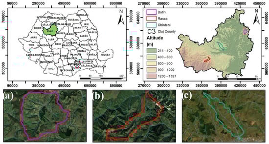
Figure 1.
The geographical location of the study areas; (a) Batin river basin, (b) Risca river basin, (c) Chinteni river basin.
Of the total area of the county, 63.8% is occupied by agricultural land, 25.1% by forest land, 2.9% by constructions, 1.8% by roads, and 5% by degraded and unproductive land. The hilly area of Cluj County is geographically part of the greater Transylvanian Depression. This represents the largest inter Carpathian negative morphological area, formed during the alpine cuts, with a general appearance of hills and plateaus, tectonically compartmentalized into sequences of geomorphological zones, arranged almost concentrically, in increasingly lower steps, from the outside to the inside, with great variations in structure and relief from one area to another [36,37].
The Transylvanian plain includes the southeastern part of Cluj County, and is characterized by altitudes between 250 and 500 m, with gentle hills separated by narrow valleys, often with excess humidity, with ridges on southern exposures and with gentle slopes and slope processes on northern exposures. The average annual temperature is 8–9°C and the annual total precipitation is 500–600 mm. Starting from a partially woody vegetation, but with a dominating grassy hay vegetation, clay parent materials rich in calcium carbonate, in interaction with the other solidification factors, favored the strong dominance of bioaccumulation, forming black soils in this area: chernozem, cambic chernoziom, faeoziom, rendzina, pseudorendzine, etc. [36].
The Someşan Plateau includes the central and northwestern part of Cluj County. In the Someşan Plateau, the relief is much more energetic and active, with intense slope processes triggered over time. The southern slopes are short and steeply segmented, with ravines and torrents. The northern slopes are longer, colder, and undulating, with the general elevation between 450 and 800 m. The average annual temperature is 7–8 °C and the average annual precipitation is 600–700 mm. The specific conditions of areas in the forest area with a rainfall surplus of +50 to +100 mm annually and parent materials poorer in basic elements led to the predominance of weakly to moderately acidic bioaccumulation and leaching, with the formation of soils from the class of luvisols: preluvosol, luvosol, etc. Pseudogleyic soils or pseudogleyic subtypes, to varying degrees, are also common.
The premontane area of the Apuseni mountains is located in the northwestern marginal part of Cluj County; although in some places it presents a gentler relief, it differs climatically and ecologically, and this continues with the montane area, where between 800 and 1200 m altitude only, some areas are still worked as arable on plateaus and southern exposures.
The three river basins (Figure 2) chosen for the IntErO model implementation belong to the three large physical-geographical units previously mentioned. The Batin river basin and village of Batin are located in the northern part of the Transylvanian Plain, the southeastern part of Cluj County, equidistant from the cities of Beclean, Dej and Gherla. The area has rich sources of water (springs, marshes), good limestone for construction, and fairly fertile soil on the hills, meadows and forests. A significant portion of the area is used for agriculture. The Rasca River Basin is a component of the premontane region of the Apuseni Mountains, and is situated in the western portion of Cluj County; it also includes Rasca Village. Rasca is one of the largest rural areas in Romania, located specifically in Romanian mountain villages, with large distances between households. The local economy is primarily based on animal husbandry and traditional agriculture, as well as tourism. Chinteni river basin incorporates Chinteni village, and is located approximately 22 km (14 miles) west of Cluj-Napoca, the county’s capital city. The region belongs to the Someşan Plateau, and is surrounded by picturesque landscape, including hills and forests, making it an attractive destination for nature lovers and outdoor enthusiasts. The local economy is primarily based on agriculture and small-scale businesses. Being in close proximity to Cluj-Napoca, in the last two decades Chinteni has transitioned to a suburb, and the built-up area of the village is in continuous expansion.
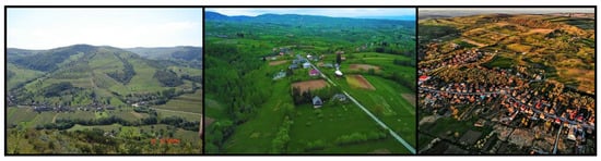
Figure 2.
Aerial photos of the three river basins with subsequent villages (Batin—(left), Rasca—(center), Chinteni—(right)).
The relief shows significant differences within the entire hilly area of Cluj County. Here are the greatest contrasts of stationary factors, due to the very rugged relief and the varied lithological substrate. In general, any relief change brings about fundamental changes in the set of local factors forming interdependencies in the topoclimate, in the characteristics of the soils, and in the physiognomy of the vegetation. The relief creates contrasts of exposures, inversions of temperature, and patches of vegetation unevenly influenced by the wind and subjected differently to precipitation, etc. The relief is what determines the differences in the characteristics of the soils, namely: deeper soils in the gentler parts of the slope, and thin and eroded soils in the strongly inclined parts.
2.2. Methodological Approach and IntErO Model
The present research study aims to utilize the IntErO model in order to predict the magnitude of soil erosion and the maximum outflow from three specific river basins located in Cluj County. The utilization of the IntErO model, in conjunction with other soil erosion models, facilitates an exhaustive understanding of the extent of erosion observed in river basins that exhibit similar characteristics throughout various global regions [1,5,9]. There have been many different models of soil erosion devised, and they have all been evaluated on a global scale. The primary issue with process-based models is that they have an excessively high number of input parameters, and there are insufficient data to evaluate the model’s predictions. Therefore, empirical models for determining the amount of soil erosion play an important part in the process of planning for soil conservation. The Erosion Potential Method (EPM) of Gavrilovic [38,39] is an empirical model that was initially developed for Yugoslavia. It has since been utilized in various research studies, particularly to explore the effect of land use on soil erosion and sediment output. The method’s ability to be used to analyze the risk of erosion using techniques and modeling spatial data (in a GIS platform) is a big advantage. The Intensity of Erosion and Outflow (IntErO) developed by Spalevic [9,40,41] is a program package for the Windows Operating System that includes the EPM as an incorporated part of the algorithm (Figure 3). As field-based erosion studies are laborious, expensive, and require a considerable amount of time, the use of soil erosion models to assess the severity of soil erosion on a regional scale is gaining favor in today’s world. In contrast to other models, models of soil erosion can quickly determine the amount of soil that has been lost, given that the relevant data are usually available and open-source.
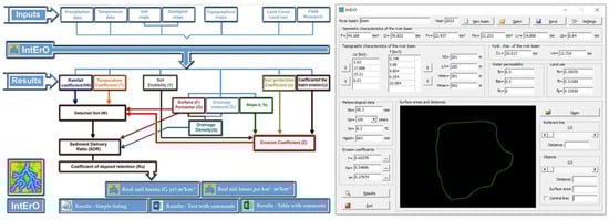
Figure 3.
IntErO model flowchart (left) and interface (right).
The IntErO model is capable of managing a large number of data, thanks to its processing of 22 inputs, which results in the return of 26 final result parameters once the calculations have been performed. Figure 3 illustrates the flowchart for the IntErO algorithm, complete with the input and output data. Due to the fact that it is founded on both descriptive and quantitative methodologies, the IntErO model might be referred to as a semi-quantitative one. This approach is the most quantitative compared to other semi-quantitative methods, since it only employs descriptive assessment for three characteristics: soil erodibility, soil protection, and the degree of erosion in the catchment. A limitation of the IntErO model is that the necessary database and workflow is time-consuming, and can be carried out on individual river basins. Thus, in order to generate erosion assessments on larger areas, it is necessary to establish numerous watershed IntErO scenarios, as opposed to USLE, RUSLE and other methods capable of generating results on large areas. Nevertheless, the IntErO model is advantageous for smaller-scale implementations, where individual river basins can be analyzed, as well as for analyzing the impact of climate change, land use and land-cover changes. Predictions and estimations can easily be obtained based on the interchangeable values from the IntErO workflow, in order to determine how the climatic factors and land use affect the erosion processes.
2.3. Data Acquisition, Physio-Geographical and Climate Characteristics
GIS geometry calculations use spatial data to deliver accurate geographical analyses and measurements. Using the GIS environment, the ArcMap 10.8, and the available data regarding the geometry of the river basins and the hydrological network, several input parameters were calculated and then inserted in the IntErO model [5,9]. These parameters, with each graphical display, are presented in Figure 4, and include: the river basin area (F), the length of the watershed (O), the area of the bigger river basin part and the area of the smaller river basin part (Fv & Fm), the natural length of the main watercourse (Lv), the shortest distance between the fountainhead and mouth (Lm), the total length of the main watercourse with tributaries (∑L), the length of the contours and area between the contours (Liz & f), and the river basin length measured with a series of parallel lines (Lb).
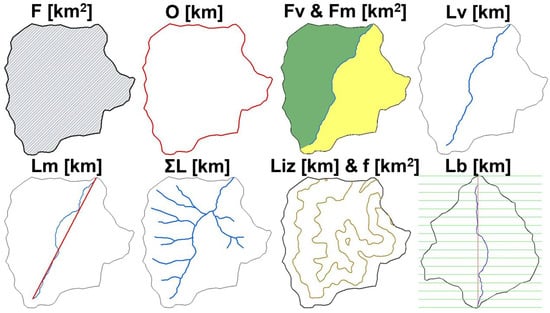
Figure 4.
Geometric input parameters extracted from GIS (display from Batin river basin).
The creation of the database imposes a specific management, in concordance with the necessary 22 inputs for the IntErO model. Considering the necessities of the model, a GIS database was created, complexly structured on vector and raster layers, starting from the primary database (contours, hydrography, soil, land cover, etc.) and moving to the derivate data (meteo data, digital elevation model, etc.).
For the DEM-derived data, such as contour levels 100 m equidistant and the maximum and minimum elevations in each river basin, the SRTM DEM with 25 m resolution was used. The Shuttle Radar Topography Mission Digital Elevation Model (SRTM DEM) is a dataset compiled from radar data gathered during the 2000 space shuttle mission by NASA. It provides global elevation data and a three-dimensional representation of the Earth’s terrain. The resolutions and precisions of the data differ, with enhanced versions available for specific regions. The SRTM DEM (Figure 5, top) is utilized extensively for cartography, terrain analysis, hydrological modeling, and infrastructure planning. It is open to the public and has become a valuable resource for scientific and commercial applications worldwide [42].
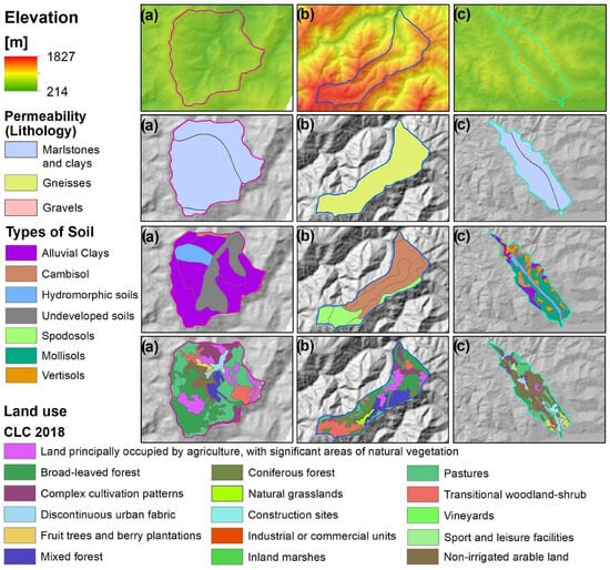
Figure 5.
Databases used in the modeling process.
This investigation considered the geological structure of the terrain in terms of the permeability and erodibility of rocks. The geological map for the study area necessary for the permeability was extracted from The International Hydrogeological Map of Europe, scale 1:1,500,000 (Figure 5, top middle). The International Hydrogeological Map of Europe (IHME) is a project that seeks to standardize the representation of hydrogeological data throughout Europe. It combines information from multiple sources to generate a unified map depicting aquifers, groundwater flow, quality, and other pertinent parameters. The IHME promotes data standardization and harmonization, thereby facilitating international collaboration and consistent groundwater-management practices. It supports sustainable water management, planning, and decision-making processes, serving as a valuable resource for policymakers, water resource administrators, and researchers [43].
The soil database was constructed by digitizing 1:200,000 scale maps with the SRCS ICPA-1980 (Romanian Soil Classification System), naming and updating them to the FAO UNESCO SRTS 2003 (Romanian Soil Taxonomy System) designations (Figure 5, bottom middle) [8,19].
Corine Land Cover (CLC) is a dataset that provides information on land cover and land use across Europe. It is produced by the European Environment Agency (EEA) and provides valuable information for various applications and disciplines (Figure 5, bottom). The CLC 2018 dataset is of great importance, due to its ability to monitor and assess changes in land cover over time, aid in land management and planning decisions, contribute to biodiversity conservation efforts, support climate change research, and facilitate cross-border and international cooperation. The CLC 2018 dataset is essential for environmental monitoring, land management, biodiversity conservation, climate change research, and international cooperation. It allows for the monitoring of land cover changes, aids in informed decision making for land management and planning, supports biodiversity conservation efforts, helps study climate change impacts, and enables cross-border collaboration and harmonization of land cover data in Europe [44,45].
In order to generate the average annual precipitation and average-annual-temperature-figure datasets regarding the rainfall and temperature, multiannual datasets were used from meteorological stations nearest to the three river basins. The average annual temperature and precipitation were calculated as 8.1 °C and 653 mm for Batin, 4.7 °C and 939 mm for Rasca, and 8.4 °C and 681 mm for Chinteni. The values are based on the meteorological station data from Cluj County, and the GIS climate figures developed (Figure 6).
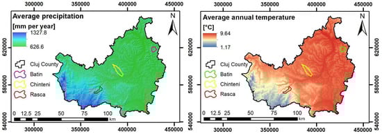
Figure 6.
Average annual precipitation and temperature map of Cluj County.
In terms of precipitation, the highest amounts occur in summer, 200–300 mm, and the lowest in winter, 70–120 mm. The torrential nature of the summer rains is particularly intense [36]. They activate torrential erosion and landslides. In the rainy years, the amount of precipitation almost doubles compared to the multiannual average, which leads to the exaggerated rise of the river levels (up to 5–8 m) and is the cause of catastrophic floods, especially because of the lack of forests and forest curtains, especially in the TAUs situated in the flatter areas with 4–6% degrees of forestation. This percentage is far below the limit of 16% afforestation (per physical-geographical unit), which is considered the limit below which the susceptibility to desertification is very high. For the hilly area of Cluj County, the critical period from the point of view of rain erosion is represented by the months of May, June and July.
3. Results
3.1. RUSLE Erosion Modeling in Cluj County
Soil loss due to water erosion threatens the sustainability of agriculture and food security. The soil is a limited natural resource that can only be used after it has had thousands of years to develop. According to Greiner [46], the sustainability of this ecosystem is vital for the production of food, as well as many other products and services that ecosystems provide, such as the management of climate and the cycling of nutrients. However, with the current trends in erosion, urbanization, and climate change, impacts that promote the decline of its surface layers (which are more fertile) constitute a concern for current and future generations [47,48].
Based on the integration of the RUSLE model as a spatial analysis model into the GIS software, the evaluation of the soil erosion rate was carried out. The main goal of this model, which was to calculate annual soil losses, was to assess the danger that soil erosion poses. The model is a useful tool that can be used to coordinate the appropriate management of soil erosion-sensitive areas, since it plays a predictive role regarding the development of affected regions over the medium and long term [5]. The model is a useful tool for effective coordination, as a result. In the case of agriculture, where the main goals are to analyze soil erodibility and quantify soil losses in order to assess land in terms of its potential for agricultural output, the RUSLE model is particularly well adapted for the evaluation of soil erosion [49]. The RUSLE model is especially suitable for this assessment.
The slope of the arable land conditions the rational use of the soil, and imposes technological and mechanization restrictions. On a national level, of the total arable land, approx. 30% are lands located on slopes and exposed to the phenomenon of erosion, and in Cluj County they represent approx. 80%. Soil erosion, with water from precipitation as a triggering factor, affects an area of 94,908.2 ha of the mapped surface, of which surface erosion represents 76,769.6 ha and the rest is deep erosion (gullies and ravines). Figure 7 illustrates the RUSLE soil erosion modeling for Cluj County and the three chosen river basins, with the results expressed in tons per hectare per year.
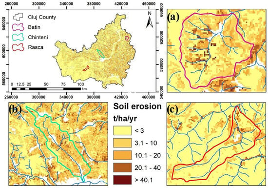
Figure 7.
Soil erosion in Cluj County and the selected river basins, based on RUSLE modeling.
The RUSLE has a significant benefit over the IntErO, in that it is a spatially explicit model, whereas the IntErO calculates sediment yield on a more global scale for the entire basin. The IntErO model also calculates maximum outflow from the river basin, the asymmetry of the river basin and the coefficients of the river basin form, watershed development, the river basin tortuousness, the region’s permeability, and vegetation cover; these parameters are also of particular importance in determining the soil loss of a landscape. This is in contrast to the RUSLE model, which is more focused on the calculation of soil loss alone. Due to its ability to determine both the sediment delivery ratio and the sediment output, IntErO has a significant advantage over RUSLE. Because not all of the erosion materials produced are lost from the river basin, RUSLE only determines gross soil-erosion rates, which may or may not include soil lost from the river basin [5]. However, the volume of soil actually leaving the river basin is represented by the sediment yield as measured by the IntErO model.
3.2. IntErO Implementation on the Three Selected Prototype River Basins in Cluj County
The results following the IntErO model implementation in the three river basins from Cluj County are presented in the following tables: Table 1, which constitutes the input data, Table 2, Table 3 and Table 4, which present the values of the factors used in the intensity of erosion and outflow for each of the river basins, and Table 5, which represents the IntErO report with the result outputs.

Table 1.
Input data for the IntErO model.
Table 2.
Values of the factors used in calculating the intensity of erosion and outflow for Batin river basin.
Table 3.
Values of the factors used in calculating the intensity of erosion and outflow for Rasca river basin.
Table 4.
Values of the factors used in calculating the intensity of erosion and outflow for Chinteni river basin.
Table 5.
IntErO report for the three river basins.
The Y, Xa and φ coefficients presented in Table 2, Table 3 and Table 4 display the soil cover, soil resistance and type/extent of erosion in each of the three river basins. The coefficient of soil cover (protection) is denoted by the letter X, and it is a dimensionless quantity that is determined by the catchment’s land use, as well as the vegetative cover. The value of this coefficient might range anywhere from 0.05 to 1. A low level of soil protection is indicated by values near to 0, while a high level of soil protection is indicated by values close to 1. Y is the coefficient of soil erodibility, which reflects the resistance of soils to erosion. It is dependent on the pedological and lithological properties of the watershed. The values of this dimensionless factor can be obtained either by studies in a laboratory or from measurements taken in the field, and the range typically extends from 0.25 to 2. Formations with values close to 2 are considered to have a high erodibility, whilst those with values close to 0.25 have a low erodibility. When conducting this research, the Y factor was determined by analyzing the data from the soil map, as well as the geological map of the study area. Following that, coefficient values were allotted to the various types of soil based on the EPM recommendations as well as the results of earlier studies [1,5,9,38,39]. φ is a coefficient that changes, depending on the amount of active erosion, as well as the degree to which linear erosion extends and the magnitude of mass movements. It is a factor that has no dimensions, and its values can vary from 0.1 to 1. According to the principles outlined in the EPM technique, a value of φ has been assigned to each distinct category of erosion form [40,41].
The data presented in Table 5 presents the calculation result of the IntErO model implementation for the three river watersheds. The coefficients of the river basin form (A), was calculated as 0.58 for Batin, 0.45 for Rasca, and 0.52 for Chinteni. The coefficient of the watershed development (m) had the values of 0.39, 0.72, 0.63, and the average river basin width (B) had the values of 3.21, 1.87, 2.54 km for the three river basins. The asymmetry coefficients (a) of the river basins were calculated as 0.02, 0.93 and 0.08, which indicates the possibility of large flood waves coming in the future for the Rasca watershed, which had a high value. The drainage density of the study river basin (G)—a key aspect affecting the flood hydrograph and erosion process is the drainage density—was calculated as 1.03, 1.08 and 0.45, which indicates that there is a medium density of the hydrographic network in the three watersheds. Maximum outflow from the river basin (Qmax) was estimated to be 26.22, 67.58 and 33.47 m3 s−1, highlighting the greater value for the mountainous Rasca river basin. According to the IntErO report, the Z coefficient for Batin and Rasca was 0.227 and 0.211, which indicates that both river basins belong to the fourth destruction category (out of five), highlighting that the strength of the erosion process is weak, and, according to the erosion type, it is surface erosion. The Z coefficient for the Chinteni watershed, estimated as 0.434, indicates that the river basin belongs to the third destruction category. The strength of the erosion process is high, and, according to the erosion type, it is mixed erosion [1,9]. The production of erosion material (W yr) in the three river basins was calculated to be 4610.5, 4429.8 and 25,236.9 m3 yr−1, and the coefficient (Ru) of the deposit retention (sediment delivery ration) was calculated as 0.207, 0.326 and 0.175. It implies that 20.7%, 32.6% and 17.5% of the total eroded material reaches the outlet point, whereas the remaining 79.3%, 67.4% and 82.5% is deposited on the basin slopes and within the hydrological drainage system. Calculated real soil losses (Ggod) per year per square kilometer for the studied river basins were estimated to be 44.73, 70.59 and 99.71 m3 km−2 yr−1, which indicates the Batin and Rasca river basins belong to the fifth category, which is a region of weak erosion. The value for the Chinteni river basins belongs to the fourth category, which is a region of moderate erosion [1,9].
4. Discussion
Prevention is the most effective method for ensuring safety from the processes of soil erosion and catastrophic flooding [50]. The creation of this organized IntErO database for the river basins will aid erosion control planning, enabling a comprehensive river-basin management system. The three river basins that were selected to be representative of the most significant geographic locations in Cluj County were evaluated for soil erosion and sediment yield, using the IntErO model in this study. According to the model’s conclusions, an increase in the intensity of flooding should be expected as a result of the recent change in land use. According to the results of the study, the river basins fall into the fourth and third destruction category, which indicates that the rate of erosion is from low to moderate, and that the major kind of erosion is surface erosion, with Chinteni having mixed erosion. The growth of agricultural land, and the degradation of forest lands, as well as deforestation, are all factors that are contributing to an increase in the peak flow and sediment yield in the areas [51,52,53]. Compared to the Batin river basin, which according to geographical characteristics has a depression landform and real soil losses of 44.73 m3 km−2 yr−1, Rasca belongs to the Western Romanian Carpathians, and has real soil losses of 70.59 m3 km−2 yr−1. The results are justifiable, given the significantly increased slopes in Rasca and the lower permeability, due to the abundance of gneisses (Figure 5). The Chinteni river basin registered the highest values, respectively a real soil loss of 99.71 m3 km−2 yr−1. The results are directly correlated to the land use of the area (Figure 8), given that the Chinteni river basin had the highest percentage of ploughland, with 64.79%, as opposed to 30.31% for Batin and 20.83% for Rasca. The very low percentage of well-consolidated forests also influenced the higher value of erosion in the Chinteni river basin, considering the value of 8.48% as opposed to 28.52% for Batin and 64.79% for Rasca. Also, as highlighted in Figure 5, the predominant type of soils in the Chinteni river basin are mollisols, which have an increased erosion susceptibility.
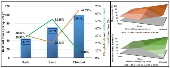
Figure 8.
The real soil losses on the three river basins, with the correlation to land use.
The findings of this study align with the research conducted by Rodrigo-Comino et al. [12], which demonstrates a direct correlation between the intensity of soil erosion and agricultural practices. Furthermore, a multitude of methodologies and research findings have consistently highlighted the need to implement crop rotation practices as a means to mitigate soil erosion [5]. Agriculture plays a crucial role in land management, since it serves as the primary means for mitigating soil erosion. This phenomenon is observable across several crop varieties, resulting in a decrease in the severity of soil erosion due to the regrowth of vegetation [9,50].
The strain exerted on agricultural and forest land in Romania has been significantly amplified in recent decades, due to anthropogenic forces. The consequence of this phenomenon has led to a decline in the vegetation cover, subsequently resulting in significant degradation and depletion of rich soil. In addition to agricultural mismanagement and land use practices, water-induced erosion is identified as the primary form of soil erosion in Romania [8,33]. The primary factors that contribute significantly to water erosion are precipitation and the resulting runoff. Additionally, it is worth noting that fluvial erosion in streams can also generate water erosion. The erosion described can exert a notable influence on the topography, owing to the notably elevated quantities of precipitation observed in some regions of the nation.
5. Conclusions
The outcomes of this study indicate the importance of factors such as rainfall, temperature, soil, land use, and geology, in the modeling and estimation of sediment yield and maximum discharge in each of the prototype river basins selected. The proliferation of the erosion phenomena in Cluj County, Romania, can be attributed to a diverse range of factors. The sources encompass a combination of natural and anthropogenic influences. The attributes of the river basins within the studied region exerted a substantial influence on the extent of soil erosion. The aforementioned elements encompassed the spatial arrangement of the land, the study of water in the region, and the physical features of the landscape. Furthermore, the geological composition and permeability of the rocks, the diverse range of land use and land cover, and the magnitude of the strong precipitation events were all significant factors to be taken into account. The observed soil erosion rate in the Chinteni river basin was 99.71 m3 km−2 yr−1, twice as high as that in Batin, despite the similarities in their characteristics. This finding indicates that the Chinteni region is experiencing significant degradation, and emphasizes the urgent need for the deployment of soil conservation measures in the area. Calculating the soil loss rate and maximum outflow using the IntErO model compares favorably to difficult alternatives regarding field-based methods of estimating sediment yield, due to these methods requiring significant work and a significant amount of time to provide comparable findings. Following the model’s calibration and validation processes, it will be possible to use it to analyze similar river basins in Romania and other regions of Europe. The findings of this study can provide policymakers with useful information for developing improved guidelines for soil and water conservation, which will conserve the soils of the river basins, as well as the future implementation of the IntErO model, in order to analyze the impact of climate change, land use and land cover changes.
Author Contributions
All authors have contributed equally to the work. All authors have read and agreed to the published version of the manuscript.
Funding
This research was funded by UASMV Bucharest, through the project “PROINVENT”, Contract no. 62487/03.06.2022 POCU/993/6/13—cod SMIS: 153299 financed by The Human Capital Operational Programme 2014–2020 (POCU), Romania.
Institutional Review Board Statement
Not applicable.
Informed Consent Statement
Not applicable.
Data Availability Statement
Not applicable.
Acknowledgments
This work of Paul Sestras was supported by the project “PROINVENT”, Contract no. 62487/03.06.2022 POCU/993/6/13—cod SMIS: 153299 financed by The Human Capital Operational Programme 2014–2020 (POCU), Romania.
Conflicts of Interest
The authors declare no conflict of interest.
References
- Mohammadi, M.; Khaledi Darvishan, A.K.; Spalevic, V.; Dudic, B.; Billi, P. Analysis of the Impact of Land Use Changes on Soil Erosion Intensity and Sediment Yield Using the IntErO Model in the Talar Watershed of Iran. Water 2021, 13, 881. [Google Scholar] [CrossRef]
- Eswaran, H.; Lal, R.; Reich, P.F. Land degradation: An overview. In Responses to Land Degradation; Oxford Press: New Delhi, India, 2001; pp. 20–35. [Google Scholar]
- Zabihi, M.; Mirchooli, F.; Motevalli, A.; Khaledi Darvishan, A.; Pourghasemi, H.R.; Zakeri, M.A.; Sadighi, F. Spatial modelling of gully erosion in Mazandaran Province, northern Iran. Catena 2018, 161, 1–13. [Google Scholar] [CrossRef]
- Novara, A.; Pisciotta, A.; Minacapilli, M.; Maltese, A.; Capodici, F.; Cerdà, A.; Gristina, L. The impact of soil erosion on soil fertility and vine vigor. A multidisciplinary approach based on field, laboratory and remote sensing approaches. Sci. Total Environ. 2018, 622, 474–480. [Google Scholar] [CrossRef] [PubMed]
- Chalise, D.; Kumar, L.; Spalevic, V.; Skataric, G. Estimation of Sediment Yield and Maximum Outflow Using the IntErO Model in the Sarada River Basin of Nepal. Water 2019, 11, 952. [Google Scholar] [CrossRef]
- Verheijen, F.G.A.; Jones, R.J.A.; Rickson, R.J.; Smith, C.J. Tolerable versus actual soil erosion rates in Europe. Earth Sci. Rev. 2009, 94, 23–38. [Google Scholar] [CrossRef]
- Hazbavi, Z.; Sadeghi, S.H.; Gholamalifard, M. Dynamic analysis of soil erosion-based watershed health. Geogr. Environ. Sustain. 2019, 12, 43–59. [Google Scholar] [CrossRef]
- Costea, A.; Bilasco, S.; Irimus, I.-A.; Rosca, S.; Vescan, I.; Fodorean, I.; Sestras, P. Evaluation of the Risk Induced by Soil Erosion on Land Use. Case Study: Guruslău Depression. Sustainability 2022, 14, 652. [Google Scholar] [CrossRef]
- Spalevic, V.; Barovic, G.; Vujacic, D.; Curovic, M.; Behzadfar, M.; Djurovic, N.; Dudic, B.; Billi, P. The Impact of Land Use Changes on Soil Erosion in the River Basin of Miocki Potok, Montenegro. Water 2020, 12, 2973. [Google Scholar] [CrossRef]
- Dragicevic, N.; Karleusa, B.; Ozanic, N. Different Approaches to Estimation of Drainage Density and Their Effect on the Erosion Potential Method. Water 2019, 11, 593. [Google Scholar] [CrossRef]
- Batista, P.V.G.; Silva, M.L.N.; Silva, B.P.C.; Curi, N.; Bueno, I.T.; Júnior, F.W.A.; Davies, J.; Quinton, J. Modelling spatially distributed soil losses and sediment yield in the upper Grande River Basin-Brazil. Catena 2017, 157, 139–150. [Google Scholar] [CrossRef]
- Rodrigo-Comino, J.; Keesstra, S.; Cerdà, A. Soil Erosion as an Environmental Concern in Vineyards: The Case Study of Celler del Roure, Eastern Spain, by Means of Rainfall Simulation Experiments. Beverages 2018, 4, 31. [Google Scholar] [CrossRef]
- Rodrigo-Comino, J.; Taguas, E.; Seeger, M.; Ries, J.B. Quantification of soil and water losses in an extensive olive orchard catchment in Southern Spain. J. Hydrol. 2018, 556, 749–758. [Google Scholar] [CrossRef]
- Feng, T.; Wei, W.; Chen, L.; Rodrigo-Comino, J.; Die, C.; Feng, X.; Ren, K.; Brevik, E.C.; Yu, Y. Assessment of the impact of different vegetation patterns on soil erosion processes on semiarid loess slopes. Earth Surf. Process. Landf. 2018, 43, 1860–1870. [Google Scholar] [CrossRef]
- Wang, W.; Shao, Q.; Yang, T.; Peng, S.; Xing, W.; Sun, F.; Luo, Y. Quantitative assessment of the impact of climate variability and human activities on runoff changes: A case study in four catchments of the Haihe River basin, China. Hydrol. Processes 2013, 27, 1158–1174. [Google Scholar] [CrossRef]
- Ghanbarian, B.; Sahimi, M.; Daigle, H. Modeling relative permeability of water in soil: Application of effective-medium approximation and percolation theory. Water Resour. Res. 2016, 52, 5025–5040. [Google Scholar] [CrossRef]
- Gocić, M.; Dragićević, S.; Radivojević, A.; Martić Bursać, N.; Stričević, L.; Đorđević, M. Changes in Soil Erosion Intensity Caused by Land Use and Demographic Changes in the Jablanica River Basin, Serbia. Agriculture 2020, 10, 345. [Google Scholar] [CrossRef]
- Vaezi, A.R.; Abbasi, M.; Bussi, G.; Keesstra, S. Modeling sediment yield in semi-arid pasture micro-catchments, NW Iran. Land Degrad. Dev. 2017, 28, 1274–1286. [Google Scholar] [CrossRef]
- Jiang, N.; Yao, F.; Liu, T.; Chen, Z.; Hu, C.; Geng, X. Estimating the Soil Erosion Response to Land-Use Change Using GIS-Based RUSLE and Remote Sensing: A Case Study of Heilongjiang Province, China. Sustainability 2023, 15, 8004. [Google Scholar] [CrossRef]
- Thomas, J.; Joseph, S.; Thrivikramji, K. Assessment of soil erosion in a tropical mountain river basin of the southern Western Ghats, India using RUSLE and GIS. Geosci. Front. 2018, 9, 893–906. [Google Scholar] [CrossRef]
- Jain, M.K.; Das, D. Estimation of sediment yield and areas of soil erosion and deposition for watershed prioritization using GIS and remote sensing. Water Resour. Manag. 2010, 24, 2091–2112. [Google Scholar] [CrossRef]
- Spalevic, V.; Lakicevic, M.; Radanovic, D.; Billi, P.; Barovic, G.; Vujacic, D.; Sestras, P.; Darvishan, A.K. Ecological-Economic (Eco-Eco) Modelling in the River Basins of Mountainous Regions: Impact of Land Cover Changes on Sediment Yield in the Velicka Rijeka, Montenegro. Not. Bot. Horti Agrobot. Cluj-Napoca 2017, 45, 602–610. [Google Scholar] [CrossRef]
- Ghosh, A.; Rakshit, S.; Tikle, S.; Das, S.; Chatterjee, U.; Pande, C.B.; Alataway, A.; Al-Othman, A.A.; Dewidar, A.Z.; Mattar, M.A. Integration of GIS and Remote Sensing with RUSLE Model for Estimation of Soil Erosion. Land 2023, 12, 116. [Google Scholar] [CrossRef]
- Van Eck, C.M.; Nunes, J.P.; Vieira, D.C.; Keesstra, S.; Keizer, J.J. Physically-Based Modelling of the Post-Fire Runoff Response of a Forest Catchment in Central Portugal: Using Field versus Remote Sensing Based Estimates of Vegetation Recovery. Land Degrad. Dev. 2016, 27, 1535–1544. [Google Scholar] [CrossRef]
- Efthimiou, N.; Lykoudi, E.; Panagoulia, D.; Karavitis, C. Assessment of soil susceptibility to erosion using the EPM and RUSLE Models: The case of Venetikos River Catchment. Glob. NEST J. 2016, 18, 164–179. [Google Scholar]
- Lazzari, M.; Gioia, D.; Piccarreta, M.; Danese, M.; Lanorte, A. Sediment yield and erosion rate estimation in the mountain catchments of the Camastra artificial reservoir (Southern Italy): A comparison between different empirical methods. Catena 2015, 127, 323–339. [Google Scholar] [CrossRef]
- Parteli, E.J.; Da Silva, L.R.; Andrade, J.S., Jr. Self-organized percolation in multi-layered structures. J. Stat. Mech. Theory Exp. 2010, 2010, P03026. [Google Scholar] [CrossRef][Green Version]
- Renard, K.G.; Foster, G.R.; Weesies, G.A.; Porter, J.P. RUSLE: Revised universal soil loss equation. J. Soil Water Conserv. 1991, 46, 30–33. [Google Scholar]
- Zhao, G.; Kondolf, G.M.; Mu, X.; Han, M.; He, Z.; Rubin, Z.; Wang, F.; Gao, P.; Sun, W. Sediment yield reduction associated with land use changes and check dams in a catchment of the Loess Plateau, China. Catena 2017, 148, 126–137. [Google Scholar] [CrossRef]
- Kisic, I.; Basic, F.; Nestroy, O.; Sabolic, M. Global Change-Challenges for soil management, Advances in Geoecology. In Soil Erosion under Different Tillage and Cropping Systems in Central Croatia; Catena Verlag GMBH: Reiskirchen, Germany, 2010; pp. 141–150. [Google Scholar]
- Glavan, M.; Milicic, V.; Pintar, M. Finding options to improve catchment water quality Lessons learned from historical land use situations in a Mediterranean catchment in Slovenia. Ecol. Model. 2013, 261, 58–73. [Google Scholar] [CrossRef]
- Volk, M.; Liersch, S.; Schmidt, G. Towards the implementation of the European Water Framework Directive? Lessons learned from water quality simulations in an agricultural watershed. Land Use Policy 2009, 26, 580–588. [Google Scholar] [CrossRef]
- Bilașco, Ș.; Roșca, S.; Vescan, I.; Fodorean, I.; Dohotar, V.; Sestras, P. A GIS-Based Spatial Analysis Model Approach for Identification of Optimal Hydrotechnical Solutions for Gully Erosion Stabilization. Case Study. Appl. Sci. 2021, 11, 4847. [Google Scholar] [CrossRef]
- Serbaji, M.M.; Bouaziz, M.; Weslati, O. Soil Water Erosion Modeling in Tunisia Using RUSLE and GIS Integrated Approaches and Geospatial Data. Land 2023, 12, 548. [Google Scholar] [CrossRef]
- Sestras, P.; Bilașco, Ș.; Roșca, S.; Veres, I.; Ilies, N.; Hysa, A.; Spalević, V.; Cîmpeanu, S.M. Multi-Instrumental Approach to Slope Failure Monitoring in a Landslide Susceptible Newly Built-Up Area: Topo-Geodetic Survey, UAV 3D Modelling and Ground-Penetrating Radar. Remote Sens. 2022, 14, 5822. [Google Scholar] [CrossRef]
- Bilaşco, Ş.; Roşca, S.; Păcurar, I.; Moldovan, N.; Boţ, A.; Negrușier, C.; Sestras, P.; Bondrea, M.; Naș, S. Identification of Land Suitability for Agricultural Use by Applying Morphometric and Risk Parameters Based on GIS Spatial Analysis. Not. Bot. Horti Agrobo. 2016, 44, 302–312. [Google Scholar] [CrossRef]
- Kerekes, A.H.; Poszet, S.L.; Andrea, G.Á.L. Landslide susceptibility assessment using the maximum entropy model in a sector of the Cluj–Napoca Municipality, Romania. Rev. Geomorfol. 2018, 20, 130–146. [Google Scholar] [CrossRef]
- Gavrilovic, S. A method for estimating of the average annual quantity of sediments according to the potency of erosion. Bull. Fac. For. 1962, 26, 151–168. [Google Scholar]
- Gavrilovic, S. Engineering of Torrential Flows and Erosion; Izgradnja: Belgrade, Serbia, 1972; 272p. [Google Scholar]
- Spalevic, V. Application of Computer-Graphic Methods in the Studies of Draining Out and Intensities of Ground Erosion in the Berane Valley. Master’s Thesis, Faculty of Agriculture of the University of Belgrade, Belgrade, Serbia, 1999; p. 135. [Google Scholar]
- Spalevic, V.; Dlabac, A.; Spalevic, B.; Fustic, B.; Popovic, V. Application of computer-Graphic methods in the research of runoff and intensity of ground erosion-I program “River basins”. Agric. For. 2000, 46, 19–36. [Google Scholar]
- Yang, L.; Meng, X.; Zhang, X. SRTM DEM and its application advances. Int. J. Remote Sens. 2011, 32, 3875–3896. [Google Scholar] [CrossRef]
- Duscher, K.; Günther, A.; Richts, A.; Clos, P.; Philipp, U.; Struckmeier, W. The GIS layers of the” International Hydrogeological Map of Europe 1: 1,500,000” in a vector format. Hydrogeol. J. 2015, 23, 1867. [Google Scholar] [CrossRef]
- Martínez-Fernández, J.; Ruiz-Benito, P.; Bonet, A.; Gómez, C. Methodological variations in the production of CORINE land cover and consequences for long-term land cover change studies. The case of Spain. Int. J. Remote Sens. 2019, 40, 8914–8932. [Google Scholar] [CrossRef]
- Hysa, A.; Spalevic, V.; Dudic, B.; Roșca, S.; Kuriqi, A.; Bilașco, Ș.; Sestras, P. Utilizing the Available Open-Source Remotely Sensed Data in Assessing the Wildfire Ignition and Spread Capacities of Vegetated Surfaces in Romania. Remote Sens. 2021, 13, 2737. [Google Scholar] [CrossRef]
- Greiner, L.; Kellera, A.; Grêt-Regameyb, A.; Papritzc, A. Soil function assessment: Review of methods for quantifying the contributions of soils to ecosystem services. Land Use Policy 2017, 69, 224–237. [Google Scholar] [CrossRef]
- Parsipour, H.; Popovic, S.; Behzadfar, M.; Skataric, G.; Spalevic, V. Cities expansion and land use changes of agricultural and garden lands in peri-urban villages (case study: Bojnurd). Agric. For. 2019, 65, 173–187. [Google Scholar] [CrossRef]
- Bilașco, Ș.; Hognogi, G.-G.; Roșca, S.; Pop, A.-M.; Iuliu, V.; Fodorean, I.; Marian-Potra, A.-C.; Sestras, P. Flash Flood Risk Assessment and Mitigation in Digital-Era Governance Using Unmanned Aerial Vehicle and GIS Spatial Analyses Case Study: Small River Basins. Remote Sens. 2022, 14, 2481. [Google Scholar] [CrossRef]
- Benavidez, R.; Jackson, B.; Maxwell, D.; Norton, K. A review of the (Revised) Universal Soil Loss Equation ((R) USLE): With a view to increasing its global applicability and improving soil loss estimates. Hydrol. Earth Syst. Sci. 2018, 22, 6059–6086. [Google Scholar] [CrossRef]
- Kostadinov, S.; Braunović, S.; Dragićević, S.; Zlatić, M.; Dragović, N.; Rakonjac, N. Effects of Erosion Control Works: Case Study-Grdelica Gorge, the South Morava River (Serbia). Water 2018, 10, 1094. [Google Scholar] [CrossRef]
- Khaleghi, M.R. The influence of deforestation and anthropogenic activities on runoff generation. J. For. Sci. 2017, 63, 245–253. [Google Scholar] [CrossRef]
- Myronidis, D.; Ioannou, K.; Sapountzis, S.; Fotakis, D. Development of a sustainable plan to combat erosion for an island of the Mediterranean region. Fresenius Environ. Bull. 2010, 19, 1694–1702. [Google Scholar]
- Dragicevic, N.; Karleusa, B.; Ozanic, N. Modification of erosion potential method using climate and land cover parameters. Nat. Hazards Risk 2018, 9, 1085–1105. [Google Scholar] [CrossRef]
Disclaimer/Publisher’s Note: The statements, opinions and data contained in all publications are solely those of the individual author(s) and contributor(s) and not of MDPI and/or the editor(s). MDPI and/or the editor(s) disclaim responsibility for any injury to people or property resulting from any ideas, methods, instructions or products referred to in the content. |
© 2023 by the authors. Licensee MDPI, Basel, Switzerland. This article is an open access article distributed under the terms and conditions of the Creative Commons Attribution (CC BY) license (https://creativecommons.org/licenses/by/4.0/).